
Journal of Geographical Sciences >
Post-suburbanization in Qingpu New Town: Process and formation mechanism
|
Wang Shaobo (1990-), PhD and Lecturer, specialized in economic geography and urban geography. E-mail: wshb@lzu.edu.cn |
Received date: 2022-05-21
Accepted date: 2023-03-24
Online published: 2023-07-24
Supported by
National Natural Science Foundation of China(42101160)
Science-Technology Foundation for Young Scientist of Gansu Province(21JR7RA523)
Under the wave of globalization, some cities in China, especially the so-called “megacities” are entering or have already entered the stage of post-suburbanization. The study places Shanghai suburbs in the post-suburbanization landscape and takes Qingpu New Town as an example to systematically analyze the development and formation mechanism of post-suburbanization spaces. This study reveals the features of the post-suburbanization in China as follows. Firstly, In China, post-suburbanization is achieved based on industrialization as well as on the promotion of urbanization. Although urbanization has strengthened other functions of suburban spaces aside from living and production, the production attributes of suburbs remain stable. Secondly, post-suburbanization space with the new town as the development model is an important path for a new round of suburban space growth, it has expanded the space for capital accumulation in metropolitan areas, thus promoting the possibility of reorganizing economic activities within metropolitan areas. At the same time, it focuses on the integration of industries and cities, and the simultaneous development of urbanization and industrialization. In turn, this promotes the accumulation of capital centered on the urban environment and manufacturing production. Furthermore, China’s special institutional circumstance enables its government to organize various actors to form a growth alliance, which will act together in the production of post-suburbanization space.
Key words: post-suburbanization; space production; Qingpu New Town; mechanism; urban expansion
WANG Shaobo , LUO Xiaolong , TANG Mi . Post-suburbanization in Qingpu New Town: Process and formation mechanism[J]. Journal of Geographical Sciences, 2023 , 33(7) : 1461 -1481 . DOI: 10.1007/s11442-023-2138-2
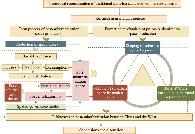
Figure 1 Conceptual framework diagram |
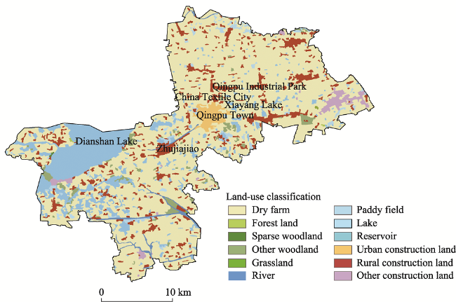
Figure 2 Land use of Qingpu District in 2000 |
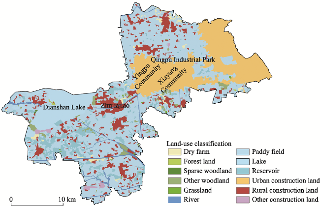
Figure 3 Land use of Qingpu District in 2020 |
Table 1 The evolution of policy space in Shanghai |
| Policy document or event | Key policy directions | Key support areas |
|---|---|---|
| 1959 “Shanghai Urban Master Plan” | Compress old urban areas, control suburbs, and develop satellite cities | Industrial zones: Minhang, Pengpu; Wujing, Taopu, Gaoqiao; Wusong; Wujing; Anting; Songjiang; Zhoupu, Yangsi, Qingning Temple Satellite cities: Jiading, Anting, Songjiang, Minhang, Wujing, Wenzaobang |
| 1965 “Sketches of the Third and Five-Year Construction of Shanghai City” | Fundamentally changed the development pattern of Shanghai’s single central city | Satellite cities: Minhang, Wujing, Jiading, Anting, Songjiang |
| In 1971, the Ministry of Petrochemicals selected a site in Jinshanwei, Shanghai | The petrochemical department selects a site in Jinshanwei, Shanghai | Satellite City: Jinshanwei |
| 1977 “Baoshan Iron and Steel Plant Peripheral Project and Baoshan Area Planning” | Ministry of Metallurgical Industry decides to build a large steel base in coastal areas | Satellite City: Baoshan |
| 1986 “Shanghai Urban Master Plan” | Build and transform the central city, enrich and develop satellite cities, develop the “two wings” step by step, and build small towns in suburban counties in a planned way | Satellite cities: Wujing, Minhang, Jiading, Anting, Songjiang, Jinshan, Wusong-Baoshan Small towns: Xinzhuang, Qingpu, Zhujing, Huinan, Chengqiao, Nanqiao |
| “Shanghai Urban Master Plan (1986-2000)” | Completion of the basic layout of the industrial park | Industrial parks: Wujing, Wusong, Beixinjing, Taopu, Songjiang, Minhang, Caohejing |
| In 1990, the development strategy of Pudong | The urban development pattern of Shanghai changed from north to south to east simultaneously | Pudong New Area |
| “Shanghai Urban Master Plan (1999-2020)” | Clarified the urban system of central city-new town, county town-central town-market town-central village | New town: Jiading, Nanhui Huinan, Jinshan, Songjiang, Chongming New Bridge, Qingpu |
Table 2 Overview of Qingpu New Town planning |
| Document | Range | Area | Population size |
|---|---|---|---|
| “Shanghai Qingpu New Town Urban Master Plan 2003-2020” | North to Shangda River, south to Huqingping Expressway, east to Youdun Port, west to West Daying Port, mainly involving Qingpu urban area | Covering an area of 26.8 km2, construction land is 20.63 km2 | 25 ten thousand |
| “Shanghai Qingpu New Town Urban Master Plan 2005-2020” | Starts from Youdun Port in the east, Huqingping Expressway in the south, Fuxing Road in the west, and Shangda River in the north, including the existing urban area of Qingpu, the extension area to the west and Zhujiajiao Township. | Covering an area of 53.8 km2, construction land is 44.26 km2 | 50 ten thousand |
| “Shanghai Qingpu New Town Urban Master Plan 2009-2020” | Expand the western boundary of the new town to the east bank of Dianshan Lake, and integrate Qingpu Industrial Park into the new city as a whole in the north. | Covering an area of 119 km2, construction land is 87 km2 | 70 ten thousand |
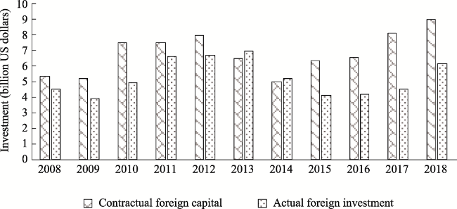
Figure 4 The contractual and actual foreign investment in Qingpu District |
Table 3 Comparison of different characteristics of post-suburbanization between China and Western countries |
| Dimension | China | Western countries |
|---|---|---|
| Spatial utilization | The production function of the suburbs is still stable | Experienced the rise of the service industry under the de-industrialization |
| Social space | The phenomenon of mixed living of diverse groups is more obvious | Mainly consists of the middle class |
| Driving force | A growth alliance is formed by multiple forces under the leadership of the government | Market and society play a relatively large role |
| Relationship between suburbs and central urban areas | Coordinated development | Accompanied by the decline of central urban areas and the disintegration of functional centers |
| [1] |
|
| [2] |
|
| [3] |
|
| [4] |
|
| [5] |
|
| [6] |
|
| [7] |
|
| [8] |
|
| [9] |
|
| [10] |
|
| [11] |
|
| [12] |
|
| [13] |
|
| [14] |
|
| [15] |
|
| [16] |
|
| [17] |
|
| [18] |
|
| [19] |
|
| [20] |
|
| [21] |
|
| [22] |
|
| [23] |
|
| [24] |
|
| [25] |
|
| [26] |
|
| [27] |
|
| [28] |
|
| [29] |
|
| [30] |
|
| [31] |
|
| [32] |
|
| [33] |
|
| [34] |
|
| [35] |
|
| [36] |
|
| [37] |
|
| [38] |
|
| [39] |
|
| [40] |
|
| [41] |
|
| [42] |
|
| [43] |
|
| [44] |
|
/
| 〈 |
|
〉 |