Regular Articles

Land consolidation and eco-environmental sustainability in Loess Plateau: A study of Baota district, Shaanxi province, China

  • BAI Yu , 1 ,
  • LIU Yansui 2, 3 ,
  • LI Yuheng , 2, 3, * ,
  • WANG Yongsheng 2, 3 ,
  • YUAN Xuefeng 4, 5
Expand
  • 1.School of Earth Science and Resources, Chang’an University, Xi’an 710054, China
  • 2.Key Laboratory of Regional Sustainable Development Modeling, Institute of Geographic Sciences and Natural Resources Research, CAS, Beijing 100101, China
  • 3.College of Resources and Environment, University of Chinese Academy of Sciences, Beijing 100049, China
  • 4.School of Land and Engineering, Chang’an University, Xi’an 710054, China
  • 5.Shaanxi Key Laboratory of Land Consolidation, Xi’an 710054, China
*Li Yuheng (1983-), PhD and Associate Professor, E-mail:

Bai Yu (1991-), PhD Candidate, E-mail:

Received date: 2021-10-21

  Accepted date: 2022-02-14

  Online published: 2022-11-25

Supported by

National Natural Science Foundation of China(41931293)

National Natural Science Foundation of China(42171208)

Fund Project of Shaanxi Key Laboratory of Land Consolidation(211927190123)

Abstract

Eco-environmental sustainability is the basis for sustainable development in ecologically fragile areas. Land consolidation plays an important role in coordinating human-land relationships and achieving economic growth and eco-environment protection. Taking the Loess Plateau as the study area, this paper diagnoses the associated eco-environmental problems and their chain effect. The research results show that the overall eco-environment of the region is still relatively fragile. An eco-environment multi-subject co-management model, a scale-differentiated management model, and an elements comprehensive management model are proposed to improve the eco-environmental management efficiency after implementing land consolidation in the plateau. This paper takes the Gully Land Consolidation Project in Baota district of Yan’an city in Shaanxi province as an example to illustrate the relationship between land consolidation and eco-environmental sustainability in the Loess Plateau. Policy implications for eco-environmental protection in the Loess Plateau are proposed.

Cite this article

BAI Yu , LIU Yansui , LI Yuheng , WANG Yongsheng , YUAN Xuefeng . Land consolidation and eco-environmental sustainability in Loess Plateau: A study of Baota district, Shaanxi province, China[J]. Journal of Geographical Sciences, 2022 , 32(9) : 1724 -1744 . DOI: 10.1007/s11442-022-2020-7

1 Introduction

With rapid urbanization and industrialization development, human activities are disturbing the eco-environment even more and are inducing many eco-environmental problems, such as the contradiction between the water supply and demand, land and vegetation degradation, the abandonment of arable land, and frequent extreme weather, among others. These problems are intertwined and can easily lead to eco-environmental degradation, destroy the ecosystem, cause damage to agricultural production and poverty in people’s lives, and hinder regional sustainable development (Aluko, 2004; Althor et al., 2018). How to efficiently protect and improve the eco-environment and promote eco-environmental sustainability has become an important issue in regional sustainable development. Land consolidation (LC) plays an important role in coordinating and improving human-land relationships (Li et al., 2018). It helps to improve agricultural production conditions by eliminating land fragmentation to form plots of optimal size in terms of property rights and uses (Palabinska and Jankava, 2017), and it is also beneficial to regional ecological and economic sustainability (Asimeh et al., 2020).
Ecologically fragile areas face various eco-environmental problems due to their instability and sensitivity to external disturbances, which can greatly restrict a region’s sustainable development. The Loess Plateau (LP) is a typical ecologically fragile area in China. With the development of urbanization and industrialization, the intensity of human activities has increased (Li et al., 2018; Liu, 2018), resulting in deterioration of the LP’s eco-environment and poverty for its residents (Fu et al., 2017; Liu et al., 2020). Eco-environmental sustainability is a fundamental proposition for the sustainable development of the LP (Liu et al., 2020). The eco-environmental management of the LP has undergone different stages, from terrace construction to afforestation and check-dam construction projects, to small-watershed comprehensive management and the Three-North Afforestation Program, and then to the Grain for Green Project (GGP) and sloping-land improvement, among others (Zhou et al., 2013). Considering the high-quality development of the LP in the new era, the purpose of LC in the LP should not be limited to soil and water loss control and the increase of arable land; it is also crucial to carry out LC to coordinate human-land relationships, improve the eco-environment, regulate the ecosystem, and promote the sustainable development of farmers, agriculture, and rural areas.
Previous studies of LC and eco-environmental sustainability in the LP were focused mainly on evaluating quantitatively the impact of LC on the eco-environment (Liu et al., 2015; Li et al., 2016, 2019) and studying sustainable development strategies for the LP (Guo et al., 2014; Hu et al., 2021; Wang et al., 2021). In general, most studies were focused on the design of LC engineering technology, the analysis of engineering effects, and the policy recommendations for sustainable development. However, against the background of constructing ecological civilization in the new era, more analysis is needed of establishing an eco-environmental management mechanism, enhancing the quality of the eco-environment, and promoting eco-environmental sustainability in the LP.
This paper investigates the eco-environmental conditions of the LP and constructs eco-environmental management models. Baota district in Shaanxi province is selected as an example to explore further the development mechanism of LC for eco-environmental sustainability in the LP.

2 Diagnosis of eco-environmental problems in Loess Plateau

The LP is in the critical ecological zone of the Yellow River Basin in China, with important ecological and economic functions, and it is a significant ecological security barrier and a vital resource and energy base in China. This paper analyzes the evolution of water resources, land resources, climate conditions, and natural ecology in the LP and diagnoses eco-environment problems based on remote-sensing and statistical data. The primary sources of research data related to each element are given in Table 1.
Table 1 Primary sources of research data
Data item Data source Publication Period
Boundary of Loess Plateau region Comprehensive
Management Plan for the Loess Plateau Region (2010-2030)
National Development and Reform Commission (https://www.ndrc.gov.cn/) -
Water resources Yellow River Water Resources Bulletin Yellow River Conservancy Commission of the Ministry of Water Resources (http://www.yrcc.gov.cn/) 1998-2019
Land use Resource and Environmental Sciences and Data Center of the Chinese Academy of Sciences https://www.resdc.cn/ 1990, 1995, 2000, 2005, 2010, 2015, 2020
Soil and water loss China Soil and Water Conservation Bulletin Ministry of Water Resources of the People’s Republic of China (http://www.mwr.gov.cn/) 2011, 2018, 2020
Quality of arable land National Arable Land Quality Grade Status Bulletin Ministry of Agriculture and Rural Affairs of the People’s Republic of China (http://www.moa.gov.cn/) 2014, 2019
Climate (precipitation, temperature, humidity, wind speed, number of strong wind days) Observed annual data of 118 meteorological stations in the Loess Plateau http://data.cma.cn/ 1960-2019
Sandstorm days China Meteorological Disasters Yearbook China Meteorological Administration (http://www.cma.gov.cn/) 1960-2020
CO2 emissions China County-level CO2
Emissions Data in China
Chen et al., 2020 1997-2017
Eco-environment quality of counties China Ecological Environment Status Bulletin Ministry of Ecology and Environment of
the People’s Republic of China (http://www.mee.gov.cn/)
2013, 2020
Normalized difference vegetation index (NDVI) MODIS NDVI (1 km × 1 km) National Aeronautics and Space Administration
(https://search.earthdata.nasa.gov/)
2000, 2020

2.1 Diagnosis of eco-environmental problems

2.1.1 Water resources

Referring to Wang et al. (2018) and Liang et al. (2015), we used the data measured at the main hydrological control stations of the mainstream of the Yellow River in the LP region (Lanzhou, Toudaoguai, Longmen, Sanmenxia, and Huayuankou) (Figure 1a) to estimate the quantity and utilization rate of the water resources in the LP. As shown in Figure 1b, the amount of natural surface water resources in the LP has been fluctuating and decreasing in recent years, and the amount of groundwater resources that do not overlap with surface water has shown a significant decreasing trend; also, the proportion of farmland irrigation water consumption in the total groundwater and surface water consumption has decreased year by year. The decrease in surface water and underground water resources and the contradiction between supply and demand of agricultural water indicate that the resource-based water shortage is relatively severe in the LP.
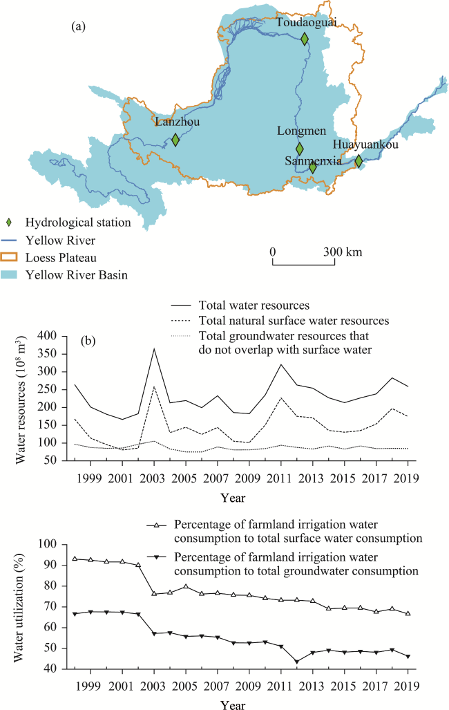
Figure 1 Locations of hydrological stations on the mainstream of the Yellow River in the Loess Plateau (LP) (a); interannual variations of water resources and resource utilization rates in the LP (b)
According to the Yellow River Water Resources Bulletin, the water quality of the LP water bodies is slightly polluted, and the primary pollution indicators are ammonia nitrogen, chemical oxygen demand, and total phosphorus. Many chemical fertilizers, pesticides, and mulch are used in agricultural production in the LP. Nitrogen, phosphorus, heavy metals, and other substances enter surface water and groundwater under rainfall and runoff, causing water pollution and damaging the eco-environment (Xiao et al., 2019). In rural life, domestic sewage and domestic waste are discharged directly without treatment, which will also cause pollution to groundwater (Hu et al., 2021). Affected by industrial wastewater, domestic sewage, and agricultural non-point source pollution, the LP also suffers from quality-based water shortage.

2.1.2 Land resources

The primary surface material in the LP region is loess, which is a type of soil with feeble resistance to blowing and erosion and that is susceptible to water and wind (He et al., 2006). Influenced by natural factors such as climate, terrain, ground slope, rainfall, and vegetation cover and by human-disturbance factors (Chen et al., 2007; Fu et al., 2017), the LP has become one of the regions in the world affected most seriously by soil and water loss (Laflen et al., 2000). According to the China Soil and Water Conservation Bulletin, the area of soil and water loss in the LP in 2020 was 208,425 km2, accounting for 36.25% of the total land area; of that eroded area, water-eroded accounted for 76% and wind-eroded accounted for 24% (Figure 2a). Although the area of soil and water loss in the LP has decreased significantly over the years, there are still problems such as a large amount and high percentage of erosion area above a moderate level (Figure 2b).
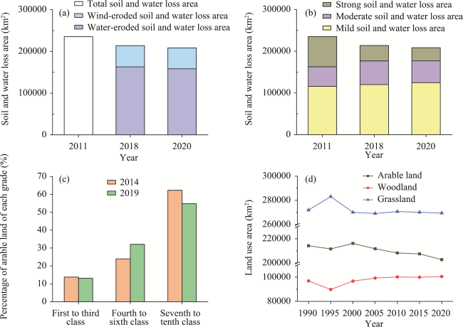
Figure 2 Soil and water loss areas of different erosion types (a); soil and water loss areas of different erosion intensities (b); percentage of arable land of various grades in total arable area (c); changes in land-use area (d) in the Loess Plateau
The northern edge of the LP is adjacent to sandy areas, and the climate there is arid. Strong winds blow frequently and carry sand into the edge of the LP, making the surface soil there sandy and loose. The influences of water shortage and irrational artificial vegetation planting cause low moisture content and weak adhesion of the soil, thereby making it easy for sandification, salinization, and desertification to form (Fu et al., 2018). Soil and water loss and land degradation alternate in time, intertwine, and superimpose in space, creating the conditions for each other to form and causing frequent land eco-environmental problems throughout the year in the LP area.
The LP is one of the regions with the strongest seismicity in China, and it is also a critical area for preventing and controlling geological disasters in China. The seismic environment with frequent strong earthquakes, the topography of gullies, and the properties of dynamic vulnerability mean that landslides and collapses have always been the most prominent geological disasters in the LP (Pu and Xu, 2019). In recent years, geological disasters such as landslides, collapses, mudslides, and torrents in the LP region have shown an increasing trend (Wang et al., 2019).
The LP has poor soil nutrients. According to the National Arable Land Quality Grade Status Bulletin, the average arable-land quality grade is 6.47. Although the quality of arable land improved between 2014 and 2019, the area of arable land evaluated as low grade (7-10) as of 2019 still accounts for 54.7% of the total arable-land area in the region (Figure 2c). In recent years, the arable-land area in the LP has continued to decrease (Figure 2d), and the phenomenon of arable-land abandonment has increased.

2.1.3 Climate conditions

The LP is sensitive to climate change. We used the annual observation data of 118 meteorological stations in the LP and adjacent areas to calculate the annual changes in precipitation, temperature, relative humidity, wind speed, and number of strong wind days from 1960 to 2019. We also calculated the average annual cumulative value of sandstorm days in the spring in northern China based on the data from the China Meteorological Disasters Yearbook. As shown in Figures 3a and 3b, the annual precipitation of the LP has increased in a fluctuating manner, the average annual temperature has increased, and the average annual relative humidity has decreased. The climate has been warm and dry in recent years. According to Sun et al. (2016), the precipitation in the LP region shows an increasing trend in spring and winter and a decreasing trend in summer and autumn, with summer precipitation dominated by extreme precipitation, which accounts for about 54% of the total precipitation. Climate change has led to an overall decrease in the average wind speed and the number of strong wind days in the LP region (Figure 3c) and a significant decrease in the annual number of sandstorm days in spring (March-May) (Figure 3d). In recent years, the number of sandstorm days in the LP has been slowly increasing. During the spring of 2021, five sandstorms occurred in the LP region, of which the one on March 14, 2021 was the most intense one encountered in China in the past decade. We also calculated the total CO2 emissions of all counties in the LP from 1997 to 2017 according to the China County-level CO2 Emissions Data (Chen et al., 2020). Total CO2 emissions in the LP region decreased only in 2015 and were still increasing year by year in recent years (Figure 4). The overall warming and drying trend, the frequent occurrence of extreme weather, and the large amount of CO2 emissions make the climate conditions in the LP still relatively harsh.
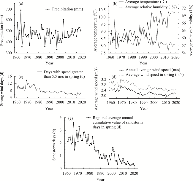
Figure 3 Annual precipitation (a); average temperature and average relative humidity (b); strong wind days in spring (c), annual average wind speed, and average wind speed in spring (d) in the Loess Plateau; regional average annual cumulative value of sandstorm days in spring in northern China (e)
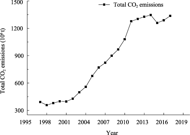
Figure 4 Total CO2 emissions in the Loess Plateau

2.1.4 Natural ecology

We extracted normalized difference vegetation index (NDVI) values with a spatial resolution of 1 km × 1 km for 2000 and 2020 in the LP using MODIS NDVI data, and we classified the magnitude of NDVI changes from 2000 to 2020 using the natural-breakpoint classification method (Jenks). The results showed that 40% of the area vegetation cover changed for the better and 26% for the worse from 2000 to 2020 (Figure 5). The vegetation cover in the LP area has improved significantly, but there is still apparent spatial and temporal heterogeneity, and vegetation degradation has occurred in some areas.
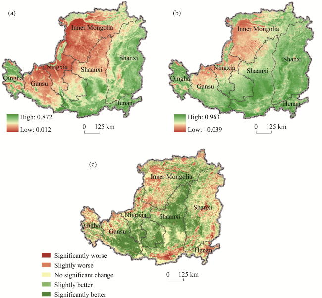
Figure 5 Normalized difference vegetation index (NDVI) values for the Loess Plateau (LP) in 2000 (a); NDVI values for LP in 2020 (b); magnitude of change in NDVI of LP from 2000 to 2020 (c)
We extracted the eco-environmental quality of the counties in the LP based on the China Ecological Environment Status Bulletin and found that about 60% of them were evaluated as “normal,” which means that the vegetation cover is moderate, the biodiversity level is normal and relatively suitable for human life, but there are constraining factors that are not suitable for human life. We calculated the changes in eco-environmental quality between 2013 and 2020, which were classified as “significantly better,” “slightly better,” “no significant change,” “slightly worse,” and “significantly worse” according to the magnitude of the difference. It is found that about 16% of the counties in the LP became better in terms of eco-environmental quality, 11% became worse, and 73% had no significant change from 2013 to 2020 (Figure 6). Implementing the GGP has significantly increased the vegetation cover in the LP but has not significantly improved the quality of the eco-environment (Feng et al., 2016; Wu et al., 2019a). At the same time, it has caused an increase in woodland and a decrease in arable land and grassland (Figure 2d), which have aggravated the contradictions between humans and land, humans and food, and cultivation and grass in the LP region (Chen et al., 2015; Shan and Xu, 2019).
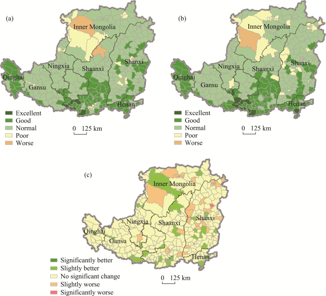
Figure 6 Eco-environmental quality in 2013 (a); eco-environmental quality in 2020 (b); magnitude of change in eco-environmental quality of the Loess Plateau from 2013 to 2020 (c)

2.2 Chain effects of eco-environmental problems

With continuous population growth and the increasing frequency, scale, and intensity of human activities, the causes of eco-environmental problems in the LP have changed from mainly natural conditions to human activities (Liang et al., 2015). The enhanced disturbance from human activities has strongly affected all elements of the eco-environment of the LP. There are extremely complex mutual feedbacks between various elements of the eco-environment, which are prone to produce a chain effect of eco-environmental problems (Figure 7).
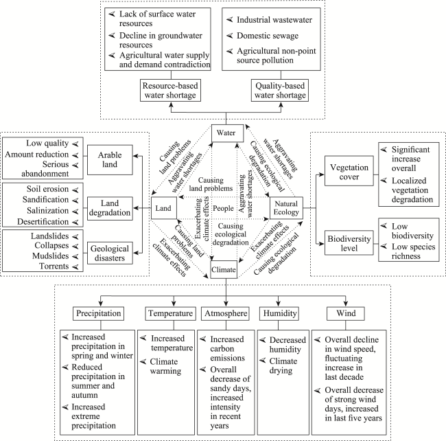
Figure 7 Chain effects of eco-environmental problems in the Loess Plateau
Water-resource constraints exacerbate the effects of climate warming and drying, causing soil desiccation and the formation of a dry soil layer (Wang et al., 2010). Water pollution changes the nature and structure of the soil, thereby reducing the quality of arable land and leading to soil and vegetation degradation.
Land degradation causes soil nutrient loss and soil water storage decrease, resulting in dry and barren soil and low yield, making the soil more susceptible to wind and water erosion (Wang et al., 2010). Soil and water loss causes a large amount of sediment to silt up in the lower reaches of the Yellow River, causing continuous siltation of the river course and greatly reducing flood regulation capacity, which can easily lead to floods, geological disasters, and aggravating soil and water loss. At the same time, the siltation of sediment reduces the reservoir capacity and, coupled with factors such as sand transport and water use, further aggravates the water-resource constraints. The dry soil layer hinders the vertical infiltration of precipitation and affects the replenishment of groundwater, resulting in decreased groundwater and a lower groundwater level (Zhang et al., 2018). Land desertification causes strong winds to involve more dust particles in the LP and increases the intensity of sandy weather. Land-use transition contributes importantly to CO2 emissions, and land-use diversity is correlated significantly with plant biodiversity (Jiang et al., 2003).
Climate warming and drying aggravate the water-resource constraints in the LP, accelerate soil nutrient loss, and lead to soil desiccation and weaken the vegetation carrying capacity of soil moisture. The increase in greenhouse-gas emissions further aggravates the warming of the LP region. Frequent extreme precipitation and changes in temperature and humid-ity cause vegetation degradation in local areas of the LP, aggravate soil and water loss, and have significant effects on the richness and diversity of plant species (Deng et al., 2016).
Since the implementation of the GGP, the vegetation cover of the LP has increased significantly. The recovery of large areas of vegetation has caused an increase in regional evapotranspiration water consumption and soil infiltration intensity, and the river runoff in the LP has decreased significantly, further aggravating the water-resource constraints (Feng et al., 2016; Ge et al., 2020). In addition, large-scale vegetation planting has aggravated soil moisture dissipation, resulting in a deepening of the soil dry layer and a continuous decrease in soil moisture (Zhang et al., 2018; Li et al., 2021). It has also led to the increase of single species and the invasion of alien species, which aggravate the damage to biodiversity.
With the in-depth implementation of the GGP and the rapid development of the economy and society, the evolution process of water resources, land resources, climate conditions, and natural ecology is influenced by more factors. Their mutual feedback becomes more complex, resulting in the chain effect of eco-environmental problems in the LP, which poses a great challenge to the eco-environmental management there.

3 Eco-environmental management model based on land consolidation

Traditional eco-environmental management in the LP is based mainly on the “government direct control” model and the “problem-oriented” model, which are suitable for facing a major outstanding eco-environmental problem and are effective in the short term. However, because the eco-environment is holistic and eco-environmental problems are multi-disciplinary, these models usually lead to contradictions among mutually exclusive management results and even overall ecological imbalance. The eco-environmental management model aimed at slowing down soil and water loss, increasing the arable-land area, and improving vegetation cover, with policy promotion as the primary means, can no longer meet the needs of ecological civilization construction in the LP in the new era. The eco-environmental management of the LP in the new era must pay more attention to the trade-off and synergy among various elements of the eco-environment, the coupling and coordination between economy and eco-environment, and the classified management and inter-regional linkage of different sub-regions of the LP.
LC uses a series of biological and engineering measures to comprehensively restore mountains, water, forests, fields, roads, villages, and counties through proper planning, layout, and design of the consolidation projects. During the consolidation process, the original state of regional eco-environmental elements is broken, and a series of ecological effects is produced, such as changes in soil properties (Quijano et al., 2017), biodiversity changes (Guo et al., 2020), and climate change (Kolis et al., 2017), among others. Changes in the eco-environmental elements and their ecological processes will have a feedback effect on the eco-environment and realize the intended eco-environmental management, which then affects the structure and function of the ecosystem and the sustainability of the eco-environment.
The effective promotion of eco-environmental management models based on LC has become the key to breaking the contradiction between economic growth and ecological protection in the LP. We propose three eco-environmental management models based on LC in the LP regarding the management mechanism, macro-pattern, and micro-operation levels. At the management-mechanism level, we propose establishing a multi-subject co-management model to improve management efficiency. At the macro-pattern level, we propose a scale- differentiated management model to scientifically lay out the types of LC projects based on different regional characteristics in the LP. At the micro-operation level, we propose an elements comprehensive management model, taking the regional eco-environmental problems as the starting point, and through specific LC engineering measures, synergistically managing water resources, land resources, climate conditions, and natural ecology to promote eco-environmental sustainability.

3.1 Multi-subject co-management model

Eco-environmental problems have multi-domain characteristics, and the model of relying on a sole subject is bound to be dysfunctional to a certain extent. Achieving a multi-win situation in eco-environmental management and stimulating the endogenous motivation of each subject is the key to fundamentally reversing the dilemma of eco-environmental management in the LP. Taking LC as an important platform for eco-environmental management, we build a multi-subject co-management model based on LC to activate multiple subjects and inject vitality into eco-environmental management (Figure 8). There are several key points about this model.
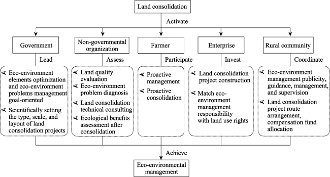
Figure 8 Multi-subject co-management model based on land consolidation
(1) The government is placed as the leader of these multiple subjects. The government needs to comprehensively consider the plight of all the eco-environment elements, the optimization of the land spatial development pattern, and the management and protection of the eco-environment, scientifically setting the type, scale, and layout of LC projects with a holistic and systematic vision, and monitoring the effectiveness of eco-environmental management.
(2) The neutral and intellectual advantages of non-governmental organizations and scientific research institutions should be fully utilized. Conduct surveys and evaluations of the current land and eco-environment situation, identify land quality and eco-environmental problems, carry out technical consultation on LC and eco-environmental management, and carry out the third-party assessments of ecological benefits after consolidation through these organizations and institutions.
(3) LC and eco-environmental management are often projects established by the government from top to bottom, and they lack the people’s spontaneous bottom-up proactive consolidation and proactive management. LC can motivate farmers to participate in village management (Wu et al., 2019b), with the motivation of improving land-use efficiency and benefits, the purpose of improving the eco-environment, and the principle of ensuring the sustainable use of land resources, encouraging farmers to participate in LC and eco-environmental management actively.
(4) Eco-environmental management requires large amounts of capital investment. Use market-oriented means to mobilize social capital to participate in eco-environmental management through LC, and encourage social capital to participate in high-standard farmland construction, arable-land quality improvement, and agricultural modernization construction. At the same time, encourage social capital to participate in the contracting and large-scale management of land after consolidation, match the responsibility of eco-environmental management with the rights of land use, and improve the efficiency and quality of eco- environmental management.
(5) The LC process involves the adjustment of land ownership, the arrangement of engineering routes, and the distribution of compensation funds, among other aspects. Eco-environmental management requires publicity, guidance, management, and supervision. Take advantage of the coordination of rural communities in uploading and reporting information to reduce the cost of LC and eco-environmental management and ensure the durability of the consolidation and management effects.

3.2 Scale-differentiated management model

It is important to clarify the strategic focus and spatial hierarchy of LC under the goal of coordinating LC projects and promoting the overall eco-environmental sustainability of the region. We constructed a scale-differentiated eco-environmental management model based on LC in the LP from the spatial level logic of “strategic area-type area-project area” (Figure 9). There are different concerns at different scales.
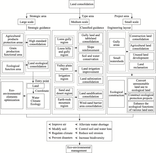
Figure 9 Scale-differentiated eco-environmental management model based on land consolidation
(1) On the large scale, take grain production functional zones, agro-products production functional zones, and ecological functional zones as targets, and implement LC based on the strategic overlay of ecological sustainability and function enhancement. Transform the strategic orientation of LC from increasing arable-land area to improving land quality and optimizing ecological functions. The core of the strategy revolves around optimizing land as the starting point and considering the coupling and coordination of other elements such as water, climate, and ecology. Based on the functional positioning of the region, in the grain production and agro-products production functional zones, carry out high-standard improvement of arable land, woodland, and grassland, and enhance the ecological function of land while improving its quality. In the ecological functional zones, carry out ecological LC and enhance the degraded ecological service function.
(2) On the medium scale, based on the natural zones of the LP, comprehensively consider the soil erosion intensity, topographic and geomorphological characteristics, water resources, and other conditions, classified guide the LC in the loess hilly and gully region, irrigation region, earth-rock mountain region, sand and desert region, valley plain region, and loess gully region. In the loess hilly and gully region and the loess gully region, focus on the consolidation of ditches and protection of slopes to continuously improve soil and water loss conditions. In the valley plain region and the irrigation region, focus on the improvement of irrigation conditions through LC to improve the utilization efficiency of water resources, as well as to improve soil salinization caused by unreasonable irrigation and optimizing the land and water elements. In the earth-rock mountain region and the sand and desert region, focus on the consolidation of sandy land and the establishment of wind-sand barrier zones to improve the land’s disaster resistance, climate, and natural ecological conditions, and optimize the climate and ecology factors.
(3) On the small scale, take small watersheds and gully areas as the targets, take the comprehensive consolidation as the means, and design LC technology with combined engineering, biological, and farming measures to improve the production-living-ecological function of the land and optimize the ecosystem service functions. Through the consolidation of various types of land, conduct ecological construction for constructing landscape patterns and diversity protection. Strengthen the consolidation of abandoned construction land and the restoration of contaminated land. In areas not suitable for cultivation, use the “LC + natural restoration” model to increase vegetation cover and regulate climate. In areas suitable for cultivation, use the “land leveling + soil reconstruction, soil-layer compounding, and soil quality improvement” model to reclamation, change land use type, reduce greenhouse-gas emissions, and help carbon neutrality (Zhou et al., 2019).

3.3 Elements comprehensive management model

LC is a process of breaking the original eco-environment and rebuilding a new one, which will have direct or indirect effects on the regional water resources, land resources, climate conditions, and natural ecology. Based on the integrity and systemic nature of the ecosystem, build elements comprehensive management model according to the diagnosis of eco-environmental problems in the LP. Set up the type and layout of LC projects and design LC technology following the principle of fortification due to problems (Figure 10). Take mountains, water, forests, fields, roads, villages, and counties as the objects of comprehensive LC, take restoring mountains, treating water, protecting forests, creating fields, paving roads, constructing drains, leveling land, managing sand, recovering green, and expanding wetland as the means of consolidation, take healthy ecosystem, coordinated human-land relationships, and rural revitalization as the consolidation goals, optimize water- land-climate-ecology, and promote the comprehensive management of the eco-environment. For different eco-environmental elements problems, different LC techniques and strategies are designed.
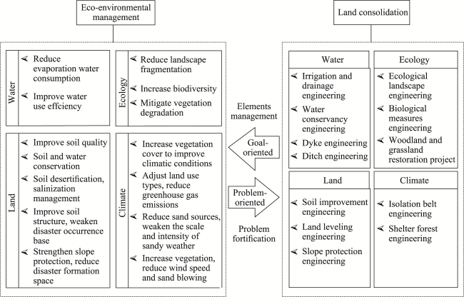
Figure 10 Comprehensive management model based on land consolidation
(1) For the problem of regional water resources, the LC focuses on the deployment of water-conservancy engineering, irrigation and drainage engineering, dyke engineering, and ditch engineering to improve the efficiency of water-resource utilization and reduce water evaporation and consumption. At the same time, improving agricultural production conditions through LC, reducing the use of pesticides and chemical fertilizers in agricultural production, and reducing the pollution of water resources.
(2) For the regional land problems, the LC focuses on the deployment of land leveling engineering, soil improvement engineering, and slope protection engineering. Through land leveling engineering and soil-body structure improvement to improve soil quality (Wang and Liu, 2020) while reducing sand sources, weakening the intensity of sandy and dusty weather, and improving the atmospheric environment. Through slope protection engineering to enhance slope surface stability, and through ecological slope protection engineering to weaken the slope scour erosion by heavy rainfall and prevent soil and water loss. Construct slope runoff diversion engineering, intercepting ditches, and drainage ditches to reduce natural disasters such as landslides, collapses, and mudslides caused by infiltration of slope runoff.
(3) For the natural ecological problems in the region, LC focuses on the deployment of ecological landscape engineering, biological measures engineering, and forest and grassland restoration engineering to reduce the degradation of regional vegetation, the fragmentation of the landscape, and protect regional biodiversity.
(4) For the regional climatic problems, LC focuses on the laying out of isolation belt engineering and shelter forest engineering. In sandy areas along the Great Wall, establish sand-blocking forest belts and wind-break forest belts through shelter forest projects to slow down the wind speed, reduce the blowing of sand and dust by the strong winds, and improve soil erosion and desertification. Through farmland shelter forest engineering reduces wind erosion and desertification erosion of the soil by strong winds and sandy weather.

4 Case study of land consolidation for eco-environmental sustainability

4.1 Gully Land Consolidation Project (GLCP)

Yan’an city in China’s Shaanxi province is in the loess hilly gully area of the LP, which is an important area of apple production. In Yan’an city, there are 44,000 gullies longer than 500 m and 20,900 gullies longer than 1000 m, and these numerous gullies contain rich land resources. In 2013, China launched a major gully LC project in Yan’an city; the project was completed at the end of November 2018, with 197 sub-projects completing a total construction scale of 362.5 km2, building 279.3 km2 of high-standard farmland, and adding 75.9 km2 of new arable land.
Based on an evaluation of ecological security and a survey of the land resources in the gully areas, the GLCP determines the type of LC combined with the current characteristics of the gully land, designs the gully LC technology based on the theory of complex watershed systems, and focuses on strengthening the six engineering measures of (i) dam system construction, (ii) slope protection, (iii) gully drainage, (iv) gully head management, (v) slope surface protection, and (vi) farmland irrigation (Liu and Li, 2017). The optimization of different eco-environment elements is considered in different engineering measures. (1) In the dam system construction engineering, flood and extreme-rainfall factors are fully considered. Flood-control dams are laid at the head of the main gully, backbone-type silt dams are built at the mouth of the main gully, and small and medium silt dams are built at the mouth of the branch gully and the middle and upper reaches of the main gully, forming a protection system of “mud control-water storage-irrigation-flood discharge” to cope with extreme rainfall and control flood disasters. (2) In the slope protection engineering, appropriate slope cutting, slope fixing, slope protection, or slope mitigating measures are carried out according to the difference of soil quality and the degree of steepness of gully slope, while engineering and biological protection measures are used to ensure slope stability, control soil and water loss, and reduce the risk of landslide and mudslide. (3) In the gully drainage engineering, flood drains are excavated, reservoirs and rain-collecting cellars are built, flood-control dams are built in the gully head management engineering, and sediment is intercepted to alleviate regional water-resource constraints. (4) In the slope surface protection engineering, interception gullies and drainage gullies are excavated to reduce the scouring and erosion of the slope surface by extreme precipitation and avoid natural disasters such as landslides, flash floods, and mudslides caused by the infiltration of slope surface runoff. At the same time, plant protection measures are used to enhance slope stability, reduce slope runoff, prevent soil and water loss, and improve the climate conditions of small watersheds. (5) In the farmland irrigation engineering, various types of reservoirs and rain-collecting cellars are laid out to weaken the impact of floods and ease the tension regarding water resources.

4.2 GLCP and eco-environmental sustainability

Baota district of Yan’an city is in the middle of the LP. The terrain of the area is high in the west and low in the east, relatively flat in the south and undulating in the north. This paper takes the GLCP in some villages in Baota district of Yan’an city as an example to evaluate the impact of the GLCP on eco-environmental sustainability.
Being in the center of the loess hilly gully area, Baota district has had many eco- environmental problems, such as the continuous decrease of groundwater level and the prominent contradiction between agricultural water supply and demand. The topography of the area is fragmented, gullies and ravines are crisscrossed and severely cut, the slopes are large, soil erosion is severe, and geological disasters are frequent. Frequent extreme weather has impacted agricultural production and soil and water conservation in the region. Vegetation in local areas is degraded, and the whole eco-environment is fragile.
The special geographic location features make the management of slopes and soil erosion the main task of this area. At the same time, as an important agricultural production area, there is an urgent need for the improvement of land quality and the construction of high-standard farmland. The implementation of the GLCP has had a great impact on the local eco-environment. The complexity of the gully areas was considered fully in the design of the GLCP, and the technical system of ecological security based on LC was constructed by diagnosing the key factors that restrict regional ecological security and exploring the interaction of water, land, climate, ecology, and other elements in the gully system. Through the construction of dam engineering and irrigation engineering, a comprehensive protection system of “mud control-water storage-irrigation-flood discharge” was formed to realize the efficient use and optimal allocation of regional water resources. Through the implementation of gully engineering and management, the stability of gullies is enhanced, soil erosion by floods and extreme precipitation is controlled effectively, salinization of the land is prevented, and the security of land production is improved. Through the implementation of slope management and protection projects, the stability of slopes is enhanced, and plant protection and ecological measures enhance the ecological conservation function and have a positive regulating effect on the regional climate.
After the implementation of the GLCP, the number and density of landscape patches have decreased, the average patch area has increased, the degree of landscape fragmentation has decreased, and the overall landscape pattern has tended to diversify and develop in a balanced manner. At the same time, the amount of soil erosion has reduced significantly, and soil and water conservation and flood control capacity have been improved significantly (Li et al., 2019). Through indoor simulation and outdoor experiments in Yangjuangou of Baota district, it was found that the GLCP dam system could effectively store rainwater, form a gully-diving reservoir, alleviate water shortage, and reduce soil erosion caused by runoff. In addition, the dam land formed after consolidation has good water-storage capacity, which can improve soil dryness (Guo et al., 2021). Calculations of the carbon emissions and carbon storage of Jiulongquangou and Yangwangou in Baota District have shown that the GLCP generally exhibits a carbon-sink effect (Lei and Mu, 2018). The diversification of landscape patterns, the decrease of soil erosion, the improvement of soil and water conservation, the increase of flood control capacity, the alleviation of water shortages, the improvement of soil dryness, and the increase of carbon storage have all led to greatly ensured eco-environmental sustainability.

5 Discussion and conclusions

5.1 Discussion

(1) LC is an important means of breaking the contradiction between economic growth and eco-environmental management in the LP. High-quality development of the LP demands the combination of LC with eco-environmental management to promote the comprehensive management of mountains, rivers, forests, farmland, lakes, grassland, and sand. It is necessary to deepen the research on the model of eco-environmental management through LC in the LP in terms of mechanism, macro-layout, and micro-operation. These include improving the LC mechanism and exploring the ecological value assessment system, ecological property rights management system, and ecological compensation mechanism. Priority should also be given to implementing land-improvement, ecological-management, and agricultural-modernization projects as well as the long-term, fixed-point monitoring of typical regional eco-environment changes. Finally, assessment is needed of human-land-industry coordination and regional sustainable development, as is analysis of the impact of LC measures on the regional eco-environment.
(2) It is necessary to strengthen the management of gullies and small watersheds in the LP based on LC. According to the ecological safety assessment and land resource surveys of the gullies and small watersheds, the management system includes setting the type and layout of LC projects, designing LC technology, and strengthening LC engineering measures. After the LC project, the following measures consist of improving the production capacity, yield, and output value of the land, developing a new agricultural production model to optimize the local industrial structure, and promoting ecological industrialization and industrial ecologicalization.

5.2 Conclusions

The analysis of water, land, climate, and natural ecology evolution and the diagnoses of eco-environmental problems in the LP show that the overall eco-environment of the region is still relatively fragile. We propose establishing a multi-subject co-management model to improve the management efficiency of LC in the LP. At the macro-pattern level, we put forward a scale-differentiated management model to scientifically lay out the types of LC projects according to the local characteristics in the LP. At the micro-operation level, we created an elements comprehensive management model to carry out collaborative management of water, land, climate, ecology, and other elements to promote eco-environmental sustainability.
This paper also presented an innovative and sustainable land-use model for the LP based on the typical practice in Baota district of Yan’an city in Shaanxi province. The implementation of the GLCP in Baota district is a typical practical verification of the theoretical model of eco-environmental management. The monitoring of various elements of the eco-environment after the project implementation also shows that the GLCP has favorably promoted the sustainable development of the regional eco-environment and made a significant contribution to the promotion of human-land harmony, eco-environmental management, and sustainable development of the LP. Promoting eco-environmental sustainability through LC has become an important path for the construction of ecological civilization in the LP in the new era.
[1]
Althor G, Mahood S, Witt B et al., 2018. Large-scale environmental degradation results in inequitable impacts to already impoverished communities: A case study from the floating villages of Cambodia. Ambio, 47(7): 747-759.

DOI

[2]
Aluko M A O, 2004. Sustainable development, environmental degradation and the entrenchment of poverty in the Niger Delta of Nigeria. Journal of Human Ecology, 15(1): 63-68.

DOI

[3]
Asimeh M, Nooripoor M, Azadi H et al., 2020. Agricultural land use sustainability in Southwest Iran: Improving land leveling using consolidation plans. Land Use Policy, 94: 104555.

DOI

[4]
Chen J, Gao M, Cheng S et al., 2020. County-level CO2 emissions and sequestration in China during 1997-2017. Scientific Data, 7(1): 391.

DOI

[5]
Chen L, Wei W, Fu B et al., 2007. Soil and water conservation on the Loess Plateau in China: Review and perspective. Progress in Physical Geography, 31(4): 3547-3554.

[6]
Chen Y, Wang K, Lin Y et al., 2015. Balancing green and grain trade. Nature Geoscience, 8(10): 739-741.

DOI

[7]
Deng L, Wang K, Li J et al., 2016. Effect of soil moisture and atmospheric humidity on both plant productivity and diversity of native grasslands across the Loess Plateau, China. Ecological Engineering, 94: 525-531.

DOI

[8]
Feng X, Fu B, Piao S et al., 2016. Revegetation in China’s Loess Plateau is approaching sustainable water resource limits. Nature Climate Change, 6(11): 1019.

DOI

[9]
Fu B, Wang S, Liu Y et al., 2017. Hydrogeomorphic ecosystem responses to natural and anthropogenic changes in the Loess Plateau of China. Annual Review of Earth and Planetary Sciences, 45(1): 223-243.

DOI

[10]
Fu C, Bian Z, Xi J et al., 2018. Spatial distribution characteristics of soil moisture in different types of sand dune in the Mu Us sandy land, adjacent to north of Chinese Loess Plateau. Environmental Earth Sciences, 77(4): 151.

DOI

[11]
Ge J, Pitman A J, Guo W et al., 2020. Impact of revegetation of the Loess Plateau of China on the regional growing season water balance. Hydrology and Earth System Sciences, 24(2): 515-533.

DOI

[12]
Guo B, Fang Y, Jin X et al., 2020. Monitoring the effects of land consolidation on the ecological environmental quality based on remote sensing: A case study of Chaohu Lake Basin, China. Land Use Policy, 95: 104569.

DOI

[13]
Guo Y, Liu Y, Wen Q et al., 2014. The transformation of agricultural development towards a sustainable future from an evolutionary view on the Chinese Loess Plateau: A case study of Fuxian County. Sustainability, 6(6): 3644-3668.

DOI

[14]
Guo Z, Gao J, Sun P et al., 2021. Influence of gully land consolidation on phreatic water transformation in the loess hilly and gully region. Water, 13(4): 538.

DOI

[15]
He X, Jie Z, Zhang X et al., 2006. Soil erosion response to climatic change and human activity during the quaternary on the Loess Plateau, China. Regional Environmental Change, 6(1/2): 62-70.

DOI

[16]
Hu Y, Zhang K, Li Y et al., 2021. Human activities increase the nitrogen in surface water on the eastern Loess Plateau. Geofluids, 2021: 9957731.

[17]
Jiang Y, Kang M, Gao Q et al., 2003. Impact of land use on plant biodiversity and measures for biodiversity conservation in the Loess Plateau in China: A case study in a hilly-gully region of the northern Loess Plateau. Biodiversity & Conservation, 12(10): 2121-2133.

[18]
Kolis K, Hiironen J, Riekkinen K et al., 2017. Forest land consolidation and its effect on climate. Land Use Policy, 61: 536-542.

DOI

[19]
Laflen J M, Tian J, Huang C H, 2000. Soil Erosion and Dryland Farming. Boca Raton: CRC Press.

[20]
Lei N, Mu X, 2018. Analysis on effect of gully control and land reclamation projects on carbon emission in hilly and gully regions of Loess Plateau. Journal of Agro-Environment Science, 37(2): 392-398. (in Chinese)

[21]
Li B, Zhang W, Li S et al., 2021. Severe depletion of available deep soil water induced by revegetation on the arid and semiarid Loess Plateau. Forest Ecology and Management, 491: 119156.

DOI

[22]
Li Y, Du G, Liu Y, 2016. Transforming the Loess Plateau of China. Frontiers of Agricultural Science and Engineering, 3(3): 181-185.

DOI

[23]
Li Y, Li Y, Fan P et al., 2019. Impacts of land consolidation on rural human-environment system in typical watershed of the Loess Plateau and implications for rural development policy. Land Use Policy, 86: 339-350.

DOI

[24]
Li Y, Wu W, Liu Y, 2018. Land consolidation for rural sustainability in China: Practical reflections and policy implications. Land Use Policy, 74: 137-141.

DOI

[25]
Liang W, Bai D, Wang F et al., 2015. Quantifying the impacts of climate change and ecological restoration on streamflow changes based on a Budyko hydrological model in China’s Loess Plateau. Water Resources Research, 51(8): 6500-6519.

DOI

[26]
Liu Y, 2018. Introduction to land use and rural sustainability in China. Land Use Policy, 74: 1-4.

DOI

[27]
Liu Y, Feng W, Li Y, 2020. Modern agricultural geographical engineering and agricultural high-quality development: Case study of loess hilly and gully region. Acta Geographica Sinica, 75(10): 2029-2046. (in Chinese)

DOI

[28]
Liu Y, Guo Y, Li Y et al., 2015. GIS-based effect assessment of soil erosion before and after gully land consolidation: A case study of Wangjiagou project region, Loess Plateau. Chinese Geographical Science, 25(2): 137-146.

DOI

[29]
Liu Y, Li Y, 2017. Engineering philosophy and design scheme of gully land consolidation in Loess Plateau. Transactions of the Chinese Society of Agricultural Engineering, 33(10): 1-9. (in Chinese)

[30]
Palabinska A, Jankava A, 2017. Relative evaluation of agricultural land for purposes of land consolidation. In:16th International Scientific Conference on Engineering for Rural Development. Latvia Univ Agr, Fac Engn, Jelgava.

[31]
Pu X, Xu S, 2019. Characteristics and mechanism of loess landslides induced by strong earthquake in the Loess Plateau of China. 2019 5th International Conference on Energy, Environment and Materials Science, Singapore: 022025-022027.

[32]
Quijano L, Van Oost K, Nadeu E et al., 2017. Modelling the effect of land management changes on soil organic carbon stocks in a mediterranean cultivated field. Land Degradation & Development, 28(2): 515-523.

DOI

[33]
Shan L, Xu B, 2019. Discussion on some issues about returning farmland to forest or grassland on Loess Plateau in new era. Bulletin of Soil and Water Conservation, 39(6): 295-297. (in Chinese)

[34]
Sun W, Mu X, Song X et al., 2016. Changes in extreme temperature and precipitation events in the Loess Plateau (China) during 1960-2013 under global warming. Atmospheric Research, 168: 33-48.

DOI

[35]
Wang K, Deng L, Shangguan Z et al., 2021. Sustainability of eco-environment in semi-arid regions: Lessons from the Chinese Loess Plateau. Environmental Science & Policy, 125: 126-134.

[36]
Wang S, Fu B, Chen H et al., 2018. Regional development boundary of China’s Loess Plateau: Water limit and land shortage. Land Use Policy, 74: 130-136.

DOI

[37]
Wang S, Peng J, Zhuang J et al., 2019. Underlying mechanisms of the geohazards of macro Loess discontinuities on the Chinese Loess Plateau. Engineering Geology, 263: 13.

[38]
Wang Y, Liu Y, 2020. New material for transforming degraded sandy land into productive farmland. Land Use Policy, 92.

[39]
Wang Y, Shao M, Shao H, 2010. A preliminary investigation of the dynamic characteristics of dried soil layers on the Loess Plateau of China. Journal of Hydrology, 381(1/2): 9-17.

DOI

[40]
Wu X, Wang S, Fu B et al., 2019a. Socio-ecological changes on the Loess Plateau of China after Grain to Green Program. Science of the Total Environment, 678: 565-573.

DOI

[41]
Wu Y, Feng W, Zhou Y, 2019b. Practice of barren hilly land consolidation and its impact: A typical case study from Fuping county, Hebei province of China. Journal of Geographical Sciences, 29(5): 762-778.

DOI

[42]
Xiao J, Wang L, Deng L et al., 2019. Characteristics, sources, water quality and health risk assessment of trace elements in river water and well water in the Chinese Loess Plateau. Science of the Total Environment, 650: 2004-2012.

DOI

[43]
Zhang S, Yang D, Yang Y et al., 2018. Excessive afforestation and soil drying on China’s Loess Plateau. Journal of Geophysical Research: Biogeosciences, 123(3): 923-935.

[44]
Zhou P, Wen A, Zhang X et al., 2013. Soil conservation and sustainable eco-environment in the Loess Plateau of China. Environmental Earth Sciences, 68(3): 633-639.

DOI

[45]
Zhou Y, Guo L, Liu Y, 2019. Land consolidation boosting poverty alleviation in China: Theory and practice. Land Use Policy, 82: 339-348.

DOI

Outlines

/