Geomorphology-oriented digital terrain analysis: Progress and perspectives

  • XIONG Liyang , 1, 2, 3 ,
  • TANG Guoan , 1, 2, 3, * ,
  • YANG Xin 1, 2, 3 ,
  • LI Fayuan 1, 2, 3
Expand
  • 1. School of Geography, Nanjing Normal University, Nanjing 210023, China
  • 2. Key Laboratory of Virtual Geographic Environment (Nanjing Normal University), Ministry of Education, Nanjing 210023, China
  • 3. Jiangsu Center for Collaborative Innovation in Geographical Information Resource Development and Application, Nanjing 210023, China
*Tang Guoan, Professor, specialized in digital terrain analysis. E-mail:

Xiong Liyang, Associate Professor, specialized in digital terrain analysis. E-mail:

Received date: 2020-10-08

  Accepted date: 2020-12-05

  Online published: 2021-05-25

Supported by

National Natural Science Foundation of China(41930102)

National Natural Science Foundation of China(41971333)

National Natural Science Foundation of China(41771415)

Copyright

Copyright reserved © 2021. Office of Journal of Geographical Sciences All articles published represent the opinions of the authors, and do not reflect the official policy of the Chinese Medical Association or the Editorial Board, unless this is clearly specified.

Abstract

Digital terrain analysis (DTA) is one of the most important contents in the research of geographical information science (GIS). However, on the basis of the digital elevation model (DEM), many problems exist in the current research of DTA in geomorphological studies. For instance, the current DTA research appears to be focused more on morphology, phenomenon, and modern surface rather than mechanism, process, and underlying terrain. The current DTA research needs to be urgently transformed from the study of landform morphology to one focusing on landform process and mechanism. On this basis, this study summarizes the current research status of geomorphology-oriented DTA and systematically reviews and analyzes the research about the knowledge of geomorphological ontology, terrain modeling, terrain derivative calculation, and terrain analytical methods. With the help of DEM data, DTA research has the advantage of carrying out geomorphological studies from the perspective of surface morphology. However, the study of DTA has inherent defects in terms of data expression and analytic patterns. Thus, breakthroughs in basic theories and key technologies are necessary. Moreover, scholars need to realize that DTA research must be transformed from phenomenon to mechanism, from morphology to process, and from terrain to landform. At present, the research development of earth science has reached the critical stage in which the DTA research should focus more on geomorphological ontology. Consequently, this study proposes several prospects of geomorphology-oriented DTA from the aspects of value-added DEM data model, terrain derivatives and their spatial relations, and macro-terrain analysis. The study of DTA based on DEM is at a critical period along with the issue on whether the current GIS technology can truly support the development of geography. The research idea of geomorphology-oriented DTA is expected to be an important exploration and practice in the field of GIS.

Cite this article

XIONG Liyang , TANG Guoan , YANG Xin , LI Fayuan . Geomorphology-oriented digital terrain analysis: Progress and perspectives[J]. Journal of Geographical Sciences, 2021 , 31(3) : 456 -476 . DOI: 10.1007/s11442-021-1853-9

1 Introduction

Geomorphology profoundly controls the redistribution of surface materials and energy, and it impacts the evolution and development of surface landscape systems and ecosystems, which also influence and determine the form and scale of human activities to a certain extent (Yang et al., 1989; Pan and Li, 1996; Zhang et al., 2006; Cui et al., 2011; Chen et al., 2015a). The research of geomorphology is viewed as a discipline that considers the morphological characteristics, formation mechanisms, distribution patterns, and evolution rules of the earth's surface. The discipline attribute and research field of geomorphology indicate its foundation role in the field of geographical research. Since the 1970s, with the development of the theory and technique of modern geographical information science (GIS), the analytical methods of traditional geography have been profoundly improved (Jiang and Chen, 2000; Zhang et al., 2003; Lun and Tong, 2008; Wang et al., 2009; Li et al., 2012b; Chen et al., 2015b; Li et al., 2016; Nan et al., 2016).
In the field of geomorphology, the basic expression mode of terrains has been fundamentally changed due to the transformation of the surface expression method. The terrain expression method has also been transformed from the contour map to the digital elevation model (DEM). With the help of DEM data, digital terrain analysis (DTA) can effectively extract and deeply analyze terrain derivatives and terrain features through GIS platforms. Tradition analytical methods in the field of geomorphology have also been fundamentally transformed with the emergence and improvement of DTA. From the perspective of research scale, DEM data with different scales can help to analyze regional landform patterns from the macro-perspective, the exploration of local landforms from the micro-perspective, and the investigation of surface reliefs and vertical landscapes from multiple oblique viewpoints. Thus, multi-scales DEMs can significantly improve the comprehensive understanding of geomorphology by using multiple scales. From the perspective of analytic dimensions, DTA methods based on DEM data are able to complete the automated extraction and analysis of different kinds of terrain attributes and features. The analytic dimensions of attributes and features have also promoted new research directions and revealed deep geographical knowledge based on the DTA methods. These works can significantly support the further exploration and understanding of deep geographical knowledge. From the perspective of a research paradigm, the current paradigm of geomorphological research has the ability to simultaneously provide quantitative, qualitative, and positional analysis. By contrast, the traditional paradigm of geomorphology research has mainly focused on analyzing qualitative descriptions and semi-quantitative expressions. This transformation of the research paradigm supports and can improve the understanding of landform characteristics, the quantitative expression of landform features, and modeling for related landform processes.
Currently, the research of DTA based on DEM gradually forms the specific theory, method, and application system of geoscience. In the GIS, geomorphology, and surveying fields, DTA has become an influential and significant direction, as it combines multiple subjects and contents. However, the current research of DTA still has several obvious problems that need to be solved, even if DTA theories and methods have completed a series of improvements. A relevant problem is that the current DTA research centers on the expression of surface morphology and the extraction of terrain attributes or features, which largely limit the comprehensive understanding of landforms from the geomorphological ontology perspectives (i.e., morphological characteristic, formation mechanism, distribution pattern, and evolution rule). In addition, besides surface morphology, the elements of landforms also involve genetic mechanisms, material components, evolution processes, and time-periods. In real scenarios, landforms take the form of different spatial objects with certain shapes on the earth's surface. These aspects are not simply abstracted geometric objects but the geographical combinations of various spatial attributes and relationships of topographical objects. The combinations contain certain tectonic structures and material components and are impacted by the earth's internal and external forces (Gan, 1980; Cai et al., 1996; Cui et al., 1996; Lu and An, 1998; Chen, 2002; Li et al., 2003; Zheng and Gao, 2003; Zhu et al., 2009; Wang, 2017). Therefore, landforms cannot be fully understood without the knowledge about their material components and their characteristics. In addition, landforms cannot be further investigated without the knowledge about the properties and transformation patterns of the biosphere, hydrosphere, and atmosphere, as they promote the development of these landforms. Thus, geomorphology-oriented DTA requires the feature investigation of earth's surface objects, requires the understanding of internal and external dynamics and processes that shape the objects, and necessitates the full consideration of the physical composition of the objects and their physicochemical properties and dynamic relationships. In addition, the theory and method of traditional geomorphology should be carefully studied, and the scientific tradition and research paradigm of geomorphological research should be fully respected. With the abovementioned requirements, the current DTA research can only be truly upgraded or improved from “form” to “process” and from “terrain” to “geomorphology.” Otherwise, DTA research may lead to the meaningless investigation of “digital games” with elevation data.
This study systematically analyzes the current state of research of geomorphology- oriented DTA. The current state of DTA research contains the understanding of geomorphological ontology and geomorphological research, the modeling of surface morphology, the extraction of terrain derivative, and the other terrain analytical methods. With the basic understanding of geomorphology-oriented DTA, this study also proposes several prospects of geomorphology-oriented DTA. These prospects include the value-added DEM data model, terrain derivatives and their spatial relations, and macro-terrain analysis.

2 Progress of geomorphology-oriented DTA

2.1 Understanding of geomorphological ontology and geomorphological research

Geomorphological ontology is the core and basis of geomorphological epistemology and methodology, and it also determines the macro-direction of geomorphological research. From the developmental aspect of geomorphology, the expanding and improving theoretical models and analytical methods can be used to reflect the development trajectory of human's understanding of geomorphological ontology. Furthermore, these models and methods have been used to form a complete epistemological system of geomorphology, which can further provide the theoretical basis of geomorphological research (Walsh et al., 1998; Ru-Lan et al., 2009). The research of geomorphological ontology and its theoretical construction can be traced back to the ancient Greek period and the Northern Song Dynasty, in which Herodotus and Kuo Shen can be viewed as the two representative scientists, respectively (Wilcock et al., 2003; Chu, 2010). The term “geomorphology” was first proposed by Lauman, a German geographer, in 1858 and has since been widely used in related research (Needham and Ling, 1959; Tinkler, 1985). Thereafter, and for quite some time, the different geomorphic evolution theories proposed by Penk and Davis have evolved into processes of thought collision and theoretical confrontation, respectively. These two different theories have been used to represent the main geomorphological ontology research and the focus of geomorphology for a period of time (Ritter et al., 1986; Oldroyd and Grapes, 2008). The two theories can also be classified into descriptive geomorphological research and deductive geomorphological research, although they have different academic views. In the 19th century, some scholars used climate-background research to explain the formation of large-scale landforms, facilitating the rise of climatic geomorphology (Lu and Guo, 2013; Shchukin, 2014). The abovementioned theoretical and modeling achievements in the recognition of landforms represent the early scholars' understanding and interpretation of geomorphological ontology.
Since the 20th century, scholars have begun to emphasize the study of dynamic geomorphology under the influence of the earth's internal and external forces (Hails, 1987; Zhou and Li, 2003; Zhao et al., 2013). The studies have gradually paid attention to the control of internal forces in the formation of landforms. Geomorphological ontology has been further studied on the basis of the interaction of the earth's internal and external forces, and many achievements supporting the formation of tectonic geomorphology, rock geomorphology, and related categories have been attained (Chen and Cui, 2009; Bowman et al., 2010; Gao et al., 2013). Those bodies of research have greatly enriched and perfected human's understanding of geomorphological ontology; subsequently, breakthroughs and improvements have also been achieved in the recognition of landform formations affected by the earth's internal and external forces, geological structures, material compositions, and other factors. The achievements have also improved the qualitative understanding of the linkage between surface morphological features and activities of the earth's deep plates, which can be regarded as a revolution in the field of geomorphology (Cheng, 2016; Lu, 2018). The development of geomorphological research during this period has provided a wealth of accumulated knowledge about geomorphological ontology, further allowing its relatively complete understanding. The studies have also prompted the description of the real causes, mechanisms, and patterns of objectively existing landforms and the scientific interpretation of landforms.
Geomorphologists have never stopped discussing the recognition and understanding of geomorphological ontology. The interpretation of geomorphological ontology has experienced the processes of transition—from shallow to deep, from partial to complete, and from single to systemic. These processes also help to form different paradigms of geomorphological research, such as erosional cycle, climatic landform, and dynamic landform. However, with the development and application of modern earth observation technologies and DTA methods, the traditional geomorphological modes of research have undergone fundamental changes. These changes require the current theory and method of DTA to be updated in view of meeting the new requirement of transformed geomorphological research. The origin problem of geomorphological ontology needs to be deeply reconsidered from the aspect of DTA. The current DTA methods can be rediscovered and updated, from which a new geomorphological paradigm can be formed on the basis of novel geographical science.

2.2 Modeling of landform morphology

The morphology of a landform is the outward manifestation of the interaction of the earth's internal and external forces with the surface material under certain time conditions. This aspect is one of the most important elements in the geographical environment. For a long time, humans have attempted to describe and express landform by using various methods to meet the needs of practical application. In the early stage of the geomorphological study, landforms had been described and summarized via pictographic mapping (Tang et al., 2015). Then, with the development of mathematics, physics, computer science, and GIS, the research about the modeling and visualization of landforms gradually became popular. Many researchers have proposed methods that support the modeling and visualization of landforms, such as the use of hill shade maps, terrain sketch maps, and contour maps, etc.
At present, with the continuous sampling and modeling of surface elevation, DEM data can achieve the digital simulation of a landform's morphology. This type of simulation enables DEM to become the most widely used model for expressing landforms. In the study of DEM data models, Wang et al. (2004) systematically summarized its six types as follows: regular grid, triangular irregular network, contour line, discrete point, section profile, and the mixed type. In addition, landform morphological modeling methods of the hybrid data model and multi-level detailed model have been proposed (Gong, 1992; Yang et al., 2005; Yue et al., 2007). In the study of DEM construction, researchers have generated DEMs by using the methods of traditional elevation interpolation, map algebra simulation, high-precision mathematical surface modeling, and feature embedded high-fidelity construction (Li and Chen, 1990; Lars and Ulrik, 1995; Carrara et al., 1997; Wilson and Gallant, 2000; Ardiansyah and Yokoyama, 2002). Some researchers have studied the interpolation methods, such as the binary spline function, Coons surface, and multi-layer surface superposition interpolation, of local terrains (Wang et al., 2008; Chen et al., 2016). These achievements have greatly improved the fidelity and practicability of landform modeling and expression.
Modern remote sensing technologies have developed rapidly in recent years. The emergence of high-resolution remote sensing image stereo measurement, synthetic aperture radar interferometry, UAV aerial survey, Lidar, and oblique photography, as well as other remote sensing methods, have greatly promoted the development of DEM data acquisition (Spaete et al., 2011; Fisher et al., 2013; Lucieer et al., 2014; Noh and Howat, 2015; Uysal et al., 2015; Dang et al., 2017; Jiang et al., 2017; Tang et al., 2018). Mass and high-precision point cloud DEM data can be easily and rapidly acquired, thus laying a solid foundation for the modeling and expression of multi-temporal, multi-level, and multi-scale landform morphology.
DEM can accurately express the geometric information of landforms. This technique not only can realistically express the earth's surface and improve the understanding of geomorphology, but it also can help to implement calculation, analysis, and visualization based on DEM data. However, DEM data only contain location and elevation information, which can only express the surface information of landforms. The internal structure and material composition of landforms cannot be easily revealed, and scientifically grasping the formation and evolution of landforms is even more difficult to conduct. In addition, the geomorphologic process is a nonlinear self-organizing dynamic evolution system with interlaced material genesis coupled with a morphological mechanism. A single morphological mathematical model often can rarely express and simulate the geomorphologic process in a scientific manner. The current DEM data with a single elevation attribute seriously restrict the in-depth study of geomorphology. Therefore, a new value-added DEM data model entailing a variety of geomorphological information should be urgently developed. This new model will help to lay the foundation for geomorphology-oriented DTA.

2.3 Extraction of terrain derivatives

The extraction and analysis of terrain derivatives based on DEM have always served as the basis and core content of DTA. These tasks are also important in expressing a landform's morphological characteristics (Liu and Tang, 2006; Ma and An, 2012; Evans, 2013; Zhou et al., 2014), simulating a landform's evolution process (Williams et al., 1990; Fu and Wang, 1994; Yang et al., 2007; Yuan et al., 2007; Minar et al., 2013), and explaining the genetic mechanism of the landform (Moharana and Kar, 2002; Li et al., 2013a; Chen et al., 2014). Thus far, more than 100 terrain derivatives have been proposed (Wilson, 2018), consequently forming a complete system of terrain derivative in DTA research. The extraction algorithms of these terrain derivatives and their stability, efficiency, and application classification have always been the research focus of geomorphometry scholars (Li, 2006; Yang et al., 2009; Gomez et al., 2015).
In the study of the terrain derivative extraction algorithm, the types of algorithm can be summarized as field factor calculation and object factor extraction (Tang et al., 2015). Field factor calculation is mainly based on raster DEM data. By calculating the relevant variables of elevation change within a certain window (Tang et al., 2005), a series of first-order or second-order terrain derivatives can be determined (Florinsky, 2009), including the slope gradient (Liu et al., 2008), slope aspect (Li et al., 2013b), slope of slope (Tang et al., 2017), slope of aspect (Tang et al., 2017), curvature (Schimidt et al., 2003), flow accumulation (Qiu et al., 2012), flow direction (Qin et al., 2006; Wu et al., 2006), terrain relief (Jiang and Yang, 2014), elevation variation coefficient (Zhou and Liu, 2006), terrain information capacity (Yang et al., 2009), and terrain complexity (Scown et al., 2015), etc. However, the object factor is different from the field factor, which is mainly oriented to specific geographical objects. Many researchers have proposed corresponding terrain derivatives according to specific objects. For instance, for the object of a river, the object factors are river network length (Sun and Wang, 2008), river network order (Tarboton et al., 1991), and runoff node density (Tang et al., 2017). For the object of a watershed, the object factors are watershed roundness (Liu et al., 1965), watershed narrow degree (Li et al., 2012a), watershed asymmetry (Li et al., 2012a), and specific catchment area (Yang et al., 2011). For the object of a gully, the object factors are gully density (Tang et al., 2017), degree of approximation from gully shoulder line to ridge (Tang et al., 2007), fluctuation frequency (Tang et al., 2007), and gully head density (Zhang, 2011).
In studying the stability and efficiency of terrain derivative extraction, the parameters of extraction efficiency and precision are improved along with the development of the research. On the one hand, the uncertainty (Tang et al., 2003; Wang et al., 2007; Wang et al., 2012), the appropriate window size (Blaschke, 2001; Li and Zhou, 2003; Zhang and You, 2013; Ariza-Villaverde et al., 2015), the object scale of terrain derivative extraction (Tang et al., 2006; Zhang and Li, 2012), and other related issues can be explored. On the other hand, the parallelized and clustered computing method for high-performance geosciences can provide a good solution to improve the efficiency of terrain derivative extraction. Many studies have shown that the speed-up ratio of the parallelized and clustered computing method is at least ten times of those of the traditional serial algorithms (Qin et al., 2009; Song et al., 2013; Ai et al., 2015; Liu et al., 2017). Scholars have also attempted to scientifically classify the proposed terrain derivatives according to characteristics. The classification sublimates the scientific cognition of the characteristics of the earth's surface and can effectively assist the quantitative study of traditional geomorphology. Thus, terrain derivatives have been systematically integrated and classified on the basis of the different aspects of application (Wood, 1996), factor complexity (Wu, 2001), computational characteristics (Florinsky, 1998), application purpose (Tang, 2014), scale characteristic (Tang, 2014), spatial relationship (Zhou and Liu, 2006), and expression form (Evans, 2012). Other researchers have proposed the corresponding terrain derivative index system by using DEMs based on specific research object and purpose (Tang, 2014).
Despite the numerous classification methods proposed by researchers, the studies regarding the expression mechanism and correlation of terrain derivatives from the perspective of the origin of geomorphology are still lacking. A terrain derivative is determined on the basis of the morphology of the landform, while a landform is determined on the basis of the earth's internal and external dynamic factors with a certain time-period. Thus, a certain landform contains its unique features of terrain derivatives and their spatial combination structure. Moreover, the combination structure of terrain derivatives reflects the formation mechanism of landform development in a region. Therefore, exploring deep-level landform features is of great significance, and revealing landform evolution rules by exploring the expression mechanism and correlation characteristic of terrain derivatives should be pursued.

2.4 Other terrain analytical methods

Apart from the extraction of terrain derivatives, DTA also includes many other analytical methods, such as terrain feature analysis, slope spectrum analysis, terrain texture analysis, and landform classification and mapping (Tang, 2014), etc. Among them, terrain features are the points, lines, and polygons (i.e., mountain peak, saddle point, ridge line, valley line, gully shoulder line, positive, and negative terrain, etc.) that express the core feature information of the landform. These core features can help to explain the basic structure and pattern of a regional terrain. In recent years, on the basis of DEM data, researchers have conducted numerous experiments on the extraction and analysis of terrain features, and many achievements have been attained (Takahashi et al., 1995; Liu et al., 1999; Pan et al., 2002; Xiong et al., 2017a). In addition, by using certain mathematical models, other researchers have constructed the terrain features of points, lines, and polygons into an integration. This integration lays the foundation for systematic terrain analysis (Zhu et al., 2015).
Since the 20th century, geo-information TUPU has been used to provide a reference for the DTA method based on TUPU (Chen et al., 2000). Through graphical representation, geo-information TUPU explores various phenomena, laws, and spatial and temporal variation characteristics in the geosciences, thus offering an important reference for geomorphological research based on terrain analysis. Many kinds of geo-information TUPUs, such as slope spectrum (Tang et al., 2008), boundary spectrum (Wu et al., 2012), profile spectrum (Li et al., 2017), integrated spectrum (Zhu et al., 2013), and texture spectrum (Tao, 2011), have been proposed with the DTA method, thus enabling preliminary research to progress further. For example, the slope spectrum of the Loess Plateau has strong correspondence with the loess landform types in different regions, reflecting the regional difference of loess landform development to a considerable extent. Meanwhile, TUPU studies have enabled DTA to realize the scientific cognition of the law and pattern of landform differentiation from the perspective of shape and mathematics.
The classification of landform types represents the core and basic theoretical issues of landform mapping (Qiu and Li, 1982). A number of landform classification research has been conducted recently following the combined principles and methods of surface morphology and formation mechanism (Cheng et al., 2011). In this aspect, researchers have achieved important progress (Shen, 1956; Li et al., 2008). Other researchers have also progressed in their classification and mapping of certain special landforms, such as the loess landform (Chen, 1956; Luo, 1956; Liu, 1985; Xiong et al., 2014; Xiong et al., 2016; Xiong et al., 2017b), eolian landform (Dong et al., 2010; Zhang and Dong, 2014), karst landform (Zeng, 1964; Qin and Zhu, 1984), and glacial landform (Cui, 1980; Wang et al., 2015). On the basis of DEM data, different automatic classification methods have been proposed for the classification and mapping of landforms (Hengl and Rossiter, 2003; Dragut and Blaschke, 2006; Guo et al., 2007; Qin et al., 2007; Cullum et al., 2017; Xiong et al., 2018).
The existing DTA methods are able to comprehensively describe and analyze the topography of an area. However, due to the defect of DEM data and the shortages of existing theories and methods, the current geomorphological research based on DTA cannot effectively express the formation mechanism of landforms. The process of occurrence and development of landforms is seldom thoroughly described. Thus, challenges still exist in the automatic classification of genetic landforms. Knowing how to embed convertible expert knowledge about landform formation mechanism into the DTA method and realize the automatic classification of landform types are the urgent issues that need to be resolved in geomorphology-oriented DTA research.

3 Perspectives of geomorphology-oriented DTA

For many years, the research of geomorphology based on DTA has focused on the perspectives of landform morphological modeling and terrain derivative extraction and analysis. In the modeling of landform morphology, from the global macro-scale to the local micro-scale and then to the lateral fine scale, the technologies of modern remote sensing, oblique photography, and GIS can realize the multi-level perception, multi-scale expression, and high-fidelity modeling of landforms. The expression of landforms based on DEM can provide the preliminary data and a basis of analysis for the external performance of geomorphic features. In terms of terrain derivative extraction, the types of terrain derivatives are constantly enriched and diversified. The derivatives can be classified as slope terrain derivatives (i.e., slope, aspect, slope length, slope shape, slope position, etc.) and watershed terrain derivatives (i.e., flow direction, flow accumulation, stream density, etc.) and even composite terrain derivatives, which focus on comprehensive geographical features (i.e., hypsometric integral, topographical wetness index, terrain power index, etc.). Different terrain derivatives can reflect the various aspects of a landform and its processes, which can enrich the knowledge of geomorphological ontology to a considerable extent. Furthermore, in the analysis of terrain derivatives, the dynamic relation between surface material flow and energy flow at different geomorphic positions in the micro-pixel scale can be achieved through the method of neighborhood or tracking analysis in DTA. The dynamic relation can help to simulate the earth's surface process in geomorphological research. For instance, in hydrologic analysis, the calculation of flow accumulation entails the scientific simulation of water flow combined with the knowledge about its dynamic relation with realized water flow.
A landform generally has a certain unique external manifestation of its surface morphology, while the surface morphology of the landform reflects the geomorphological type and its development stage. In addition, the surface morphology of a landform is the result of the earth's internal and external forces acting on the surface material. Thus, the external manifestation of these forces is a certain landform, and this landform can be described by DEM. The landform to be described by DEM reflects a certain result, in which the surface material develops to a certain stage at a certain time-period under the interaction of the earth's internal and external forces. Therefore, DEM and DTA have the natural potential and advantages of solving the problems of geomorphological ontology. Moreover, the research development trend of today's academia has reached the critical stage of DTA research, which has transformed from paying attention to surface morphology to revealing the formation mechanism of landforms. Hence, in this research, we propose the geomorphology-oriented DTA perspective by referring to the three aspects of value-added DEM data model, terrain spatial relationship, and macro-terrain analysis.

3.1 Value-added DEM data model

The traditional DTA approach of using DEM pays close attention to the study of surface morphology. However, geomorphological research is characterized by the combination of morphology and mechanism, static and dynamic, space and time, and qualitative and quantitative characteristics. From the perspective of the current research of using DEM data, landform morphology and its feature expression can only meet to a certain extent the geomorphological research needs of spatial characteristics. However, due to the lack of several major geomorphic elements in DEM research (i.e., “time” and “surface material” in geomorphological analysis), the current DTA research requiring the analysis of process and mechanism from morphology to geomorphology is difficult to achieve. For example, the surface material is often both the cause of geomorphologic phenomena and the result of geomorphologic action. Thus, in their research, scholars often analyze the distance between deposited area and provenance area according to the grain size of the loess deposit; they also judge whether the fragmental material is a glacier or debris flow deposit according to individual shape and accumulation characteristics; and they determine the age and geomorphic effect of material exposure based on the results of material dating. Unfortunately, due to the lack of effective calibration of corresponding surface material properties in the current DTA research, the geomorphology-oriented DTA has lost an important analytical support. Therefore, geomorphologic elements and properties need to be urgently added to DEM data organization and modeling. In other words, on the basis of the position and elevation (I, J, and H) elements in traditional DEM, core geomorphic elements and properties, such as “time,” “material” and “underlying topography,” are effectively added to construct a new “value-added DEM data model.” Then, a new DTA theory and method can be constructed on the basis of the new DEM data model (Figure 1). With the support of the new DEM data model and DTA method, the research is expected to be expanded from simple surface morphology analysis to geomorphic process and mechanism analysis, consequently realizing the innovation of DTA methods.
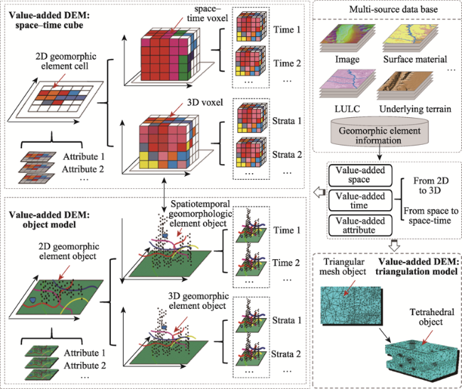
Figure 1 Geomorphology-oriented value-added DEM

3.2 Terrain derivative and its spatial relationship

The quantitative expression of landform morphology based on terrain derivatives is one of the core research contents of DTA. However, since the creation of DEM data, hundreds of terrain derivatives have been proposed, and the terrain derivatives differ from the mathematical variables. The connotation and value of terrain derivatives can be reflected only when they are combined with specific problems in geoscience. Some examples are as follows: different levels of river terraces can be judged on the basis of terrace surfaces positioned at the different distances and elevations on both sides of the river; the developmental process of loess erosion landform can be analyzed on the basis of the approaching distance of the shoulder lines to the watershed boundary lines; the planation surface in geological history can be identified on the basis of the height consistency of mountainous peaks; the prevailing wind direction can be determined according to the trend of crescent dune in aeolian landform; and the landform inheritance characteristic can be determined on the basis of the similarity between the current loess landform and the pre-Quaternary underlying paleotopography.
The analysis of spatial relationships of terrain derivatives or terrain objects to reveal morphological features and formation mechanisms has been the basic method of geomorphological research from the beginning. However, at present, the previously proposed hundreds of terrain derivatives cannot be easily used to express this kind of terrain spatial relationship. More importantly, the terrain derivatives are still in a chaotic state. The existing studies have not yet explored the effective semantic definition, functional analysis, induction and deduction, effective supplement, and system integration for the aforementioned terrain derivatives. Only then can a scientific, systematic, and practical terrain derivative system be formed from the perspective of geomorphological ontology (Figure 2). The realization of this terrain derivative system will lay an important foundation in the emergence of a new-generation DTA.
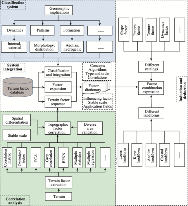
Figure 2 Geomorphology-oriented terrain derivative analysis

3.3 Macro-terrain analysis

The previous DTA research is mainly based on neighboring and tracking analysis. These analytical methods can solve the simulation and expression of the structure and process between adjacent grids to a certain extent. However, due to the limitation of “nearsightedness” with only 3×3 cells (or 5×5 cells, etc.), DTA research cannot easily solve the problems of regional geomorphologic analysis and mapping; however, these regional issues are much more important and truly need to be solved in geography. For many years, scholars have adopted the effect of the earth's internal and external forces on the surface material to build regional patterns in macro-scale landform types and units. These scholars not only need the integration and induction of geomorphic units by means of bottom-up raster cluster analysis but also the macro-scale interpretation of geomorphic patterns and the top-down decomposition and deduction of geomorphic units. The DTA research based on neighboring and tracking analysis can effectively extract geomorphic objects, which have the characteristic of significant morphological change (e.g., the loess shoulder line with a significant change in topographic relief and the watershed boundary line with a significant change in confluence direction). However, the existing analytical methods are inadequate or even powerless in determining landforms that involve complex elements and rely heavily on the comprehensive analysis of the spatial relationship of surrounding terrains. Thus, the “nearsightedness” of analysis should be alleviated, new spatial analytic theories and methods should be proposed, and scientific method innovation should be realized. In addition, landform classification and regionalization mapping are often the effective embodiment of the research results of geomorphology. However, the delineation of landform boundaries is extremely complex. In the previous studies about the delineation of different loess landform types on the Loess Plateau in China, most of them are the results of comprehensive investigation and systematic analysis of multiple topographic elements of the loess landform.
The available of massive and multi-resolution DEM data and the high-precision automatic extraction of various terrain derivatives currently provide important support for geomorphic mapping. However, the problem of geographical boundary is a complex, abstract, and comprehensive theoretical problem. A few decades ago, geomorphological scientists have manually drawn geomorphological boundaries by using expert knowledge based on topographic maps and their perceptual understanding of field work. By contrast, in the current GIS era, the primary task of current research is to scientifically refine the thoughts and knowledge from geomorphologists and transform these thoughts and knowledge into expert models that can be recognized by GIS. Therefore, the scientific understanding of “geomorphological boundary,” which is a fundamental theoretical problem of geography, and the technical requirements of geomorphic mapping need to be clarified. On this basis, current researchers need to develop a whole set of new terrain analytic theories and methods, such as terrain feature analysis, TUPU analysis, and texture analysis. Consequently, an organic whole of the geomorphological boundaries, patterns, and rules can be formed to serve as an important theoretical exploration and method of practice for landform classification and regionalization mapping based on the proposed new-generation DEM data (Figure 3).
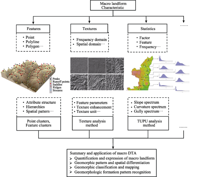
Figure 3 Macro-terrain analytical methods for macro-geomorphological characteristics

4 Discussion and conclusions

Currently, with the great progresses achieved by scholars in DTA, building a new generation of DTA oriented towards geomorphology is an inevitable requirement in the discipline development of geomorphology. As the most basic branch discipline of geography, geomorphology also urgently needs the support of modern GIS theories and technologies. The support of these theories and technologies can help the discipline of geomorphology to realize the transformation of the research paradigm and study focus from pure DEM-based surface morphological research to one that is oriented towards geomorphological ontology. If the research neglects the mechanism of landform and only focuses on the morphological features, then the inherent dialectical relationship between morphological features and its material composition cannot be easily understood. Such an incomplete knowledge may result in cognitive misunderstanding, such as the cognitive misunderstanding of viewing general platforms (or flat areas) and river terraces as the same landform type because of the lack of knowledge about the formation mechanism of these two objects. In addition, if the research only discusses morphological features and ignores the relationship between surface shape and landform mechanism, then the scientific understanding of the internal formation mechanism of the different landform development stages will be hindered. The knowledge gap can also cause an incorrect recognition of landforms, leading to the prevalence of metaphysics in the research process. Meanwhile, the causality between the elements of natural laws, formation mechanisms, and morphological characteristics may be neglected and misunderstood. Moreover, if the surface morphology is divorced from the landform formation mechanism, then the landform evolution process of the different development models cannot be effectively interpreted, and the change in landform in the whole evolution process cannot be accurately recognized. Consequently, surface morphological research will become too idealized and eventually fall into the “digital game” trap in expressing the evolution processes of geomorphological research. Finally, if the morphology is not combined with landform, then researchers cannot correctly interpret the spatial differentiation pattern of the landforms based on geography. This spatial differentiation pattern should serve as the basis of spatial distribution and reorganization of the material and energy on the earth's surface, as these elements have a great significance in the strategic adjustment of national land and resources.
The present forms of DTA research have generated analytic paradigms to extract and visualize terrain derivatives and terrain features based on DEM and terrain feature statistics and landform regionalization mapping. However, the research of DTA has currently entered an important development bottleneck period. The focus of DTAs urgently needs to be transformed from the current surface morphology to a deep research of the different aspects of geomorphological ontology. Formation mechanism, evolution process, and differentiation pattern are all necessary in the research of geomorphological ontology. The following aspects should be immediately considered by scholars working in the field of DTA.
(1) The development of various data acquisition technologies has generated important conditions to deeply investigate the causes, mechanisms, and processes of landforms. The development of geomorphology also needs the support of in-depth integration of modern geographic information technologies. Moreover, the traditional methods of DEM and DTA need to be upgraded, especially the geomorphology-oriented DTA theories and techniques, which can promote the development of geomorphology and even geography.
(2) A multi-scale, high-precision, and global coverage DEM data system has been formed recently. In addition, other related data, such as geology and surface coverage data, have become increasingly abundant. The development of data acquisition methods also provides favorable conditions for the application of the proposed value-added DEM data model. Therefore, the values for representing the information of geomorphological ontology should be added to the current DEM data model. In addition, scholars in the field of geographic information science should consider the new theories and methods of constructing value-added DEM data models and data structures.
(3) Undoubtedly, the core part of the current DTA research should be the DEM-based extraction and analysis of terrain derivatives. Preliminary statistics show that more than 100 terrain derivatives have been proposed and extracted. In future studies, researchers should clearly define the actual semantics, geomorphological meanings, and application suitability of these derivatives. In addition, terrain derivatives that can effectively describe the geomorphic mechanism, process, spatial relationship between geomorphic elements and regional geomorphic features need to be proposed.
(4) The DTA method has constantly improved the existing analytical method of terrain derivative calculation, terrain feature analysis, and terrain statistical analysis. Except for the traditional DTA methods, Chinese scientists have attempted to preliminarily explore and promote the analytical methods of terrain information TUPU and the development mechanism and process of landforms. The new methods are unique and have formed certain characteristics and advantages, further laying a foundation for the systematic conduct of geomorphology-oriented DTA research. However, the current achievements are still decentralized and in the preliminary phase. The top-level design and research planning of the system are urgently needed prior the conduct of geomorphology-oriented DTA.
On the basis of this study, we do not expect DTA to fully cover all fields of geomorphological research. On the one hand, the current status of geomorphological research involves rich expert knowledge and rules of landforms, which can serve as important foundations of DTA in the study of geomorphology. We presume that DTA research has realized the achievements of value-added DEM data model, clear spatial relationship qualification, and macro-terrain analysis. However, DTA still cannot replace the existing expert knowledge and rules of landform, such as the terrace formation and geomorphic evolution rule. On the other hand, from the perspective of geomorphological research, even if the landform evolution model takes into consideration DEM, geological time, underlying strata, surface materials, and other factors, it still needs the support of the data model, data structure, data expression, data analysis, algorithm design, and other aspects in GIS-DTA research. In addition, the construction of value-added DEM is not a simple superposition of data layers of different geomorphic elements but a re-reconstruction of the data model and data structure (i.e., a new value-added DEM construction method based on a space-time cube or tetrahedron, as shown in Figure 1).
The scientific answers and breakthroughs related to the abovementioned issues bring important theoretical and method innovations in geomorphology while enriching the research connotation of geography in the new era. This study emphasizes that constructing a new generation of geomorphology-oriented DTA is an inevitable requirement for the development of GIS. The DTA research is already in a critical crossroads. The current practice of GIS is facing the question of whether it can truly support the development of geography; furthermore, the research of DTA based on DEM is under a similar situation. In recent years, scientists around the world have deeply explored how GIS can generate its own unique theoretical and method system. The limitations of the current data processing and analytical methods should be alleviated to enable GIS to truly support the development of geography and other corresponding disciplines. Some scholars have proposed the concept of “rediscovering GIS” by basing it on the in-depth consideration of the current problems in the GIS field. Nowadays, GIS is supported by emerging technologies, such as big data, artificial intelligence, and high-performance computing. If the future research is able to initiate important breakthroughs in the analytical concepts, analytical models, and analytical methods, then they will certainly bring great changes and development. Additionally, if the research idea of geomorphology-oriented DTA can be realized, then we can expect it to become an important exploration and practice of theoretical and method innovation in the field of geographic information science.
[1]
Ai B B, Qin C Z, Zhu A X, 2015. Parallelization of regional operation algorithm using parallel raster-based geocomputation operators. Journal of Geo-Information Science, 17(5):562-567. (in Chinese)

[2]
Ardiansyah P O D, Yokoyama R, 2002. DEM generation method from contour lines based on the steepest slope segment chain and a monotone interpolation function. ISPRS Journal of Photogrammetry & Remote Sensing, 57(1):86-101.

[3]
Ariza-Villaverde A B, Jiménez-Hornero F J, De Ravé E G, 2015. Influence of DEM resolution on drainage network extraction: A multifractal analysis. Geomorphology, 241:243-254.

[4]
Blaschke T, Strobl J, 2001. What’s wrong with pixels? Some recent developments interfacing remote sensing and GIS. Geo-Informations-Systeme, 14(6):12-17

[5]
Bowman D, Svoray T, Devora S et al., 2010. Extreme rates of channel incision and shape evolution in response to a continuous, rapid base-level fall, the Dead Sea, Israel. Geomorphology, 114(3):227-237

[6]
Cai Q G, Lu Z X, Wang G P, 1996. Process-based soil erosion and sediment yield model in a small basin in the Hilly Loess Region. Acta Geographica Sinica, 51(2):108-117. (in Chinese)

[7]
Carrara A, Bitelli G, Carla R, 1997. Comparison of techniques for generating digital terrain models from contour lines. International Journal of Geographical Information Systems, 11(5):451-473

[8]
Chen C F, Liu F Y, Yan C Q et al., 2016. A huber-derived robust multi-quadric interpolation method for DEM construction. Geomatics and Information Science of Wuhan University, 41(6):803-809. (in Chinese)

[9]
Chen C K, 1956. The terrain types and development rules of loess landform in southeastern region of Gansu. Acta Geographica Sinica, 22(3):223-231. (in Chinese)

[10]
Chen F H, Dong G H, Zhang D J et al., 2015a. Agriculture facilitated permanent human occupation of the Tibetan Plateau after 3600 BP. Science, 347(6219):248-250.

PMID

[11]
Chen J, Chen L J, Li R et al., 2015b. Spatial distribution and ten years change of global built-up areas derived from GlobeLand30. Acta Geodaetica et Cartographica Sinica, 44(11):1181-1188. (in Chinese)

[12]
Chen S P, Yue T X, Li H G, 2000. Studies on Geo-Informatic Tupu and its application. Geographical Research, 19(4):337-343. (in Chinese)

[13]
Chen T, Zhang H P, Wang W T, 2014. Topographic variation along the middle-east segment of Haiyuan Fault Zone and its implications. Seismology and Geology, 36(2):449-463

[14]
Chen Y X, Cui Z J, 2009. Influence of climate and tectonic movements on granite landforms in China. Journal of Geographical Sciences, 19(5):587-599

[15]
Chen Z Y, 2002. Holocene Nile Delta sea-level fluctuations and its impact on environment: With special reference to the Changjiang River Delta. Acta Oceanologica Sinica, 24(2):77-83.

[16]
Cheng W M, Wang N, Zhao S M et al., 2016. Relative tectonics and debris flow hazards in the Beijing mountain area from DEM-derived geomorphic indices and drainage analysis. Geomorphology, 257:134-142.

[17]
Cheng W M, Zhou C H, Chai H X et al., 2011. Research and compilation of the Geomorphologic Atlas of the People’s Republic of China (1:1,000,000). Journal of Geographical Sciences, 21(1): 89‒100. 21(1):89-100.

[18]
Chu P Y, 2010. Science in Ancient China: Researches and Reflections. The Journal of Asian Studies, 60(2):538-540

[19]
Cui P, Chen X Q, Zhu Y Y et al., 2011. The Wenchuan Earthquake (May 12, 2008), Sichuan Province, China, and resulting geohazards Natural Hazards, 56(1):19-36

[20]
Cui Z J, 1980. Essential features of the development of glacial landforms on Qinghai-Xizang Plateau. Acta Geographica Sinica, 35(2):137-148. (in Chinese)

[21]
Cui Z J, Gao Q Z, Liu G N et al., 1996. Planation surface and karst age of the Qinghai-Tibet Plateau and its initial height. Chinese Science Bulletin, 41(15):1402-1406.

[22]
Cullum C, Brierley G, Perry G L W et al., 2017. Landscape archetypes for ecological classification and mapping: The virtue of vagueness. Progress in Physical Geography, 41(1):95-123.

[23]
Dang Y M, Zhang C Y, Zhou X H et al., 2017. Shoreline surveying method based on the stereo imaging and mapping. Bulletin of Surveying and Mapping, 11:47-50. (in Chinese)

[24]
Dong Z, Qu J J, Lu J H et al., 2010. Compilation of geomorphic map of the Kumtagh Desert. Journal of Desert Research, 30(3):483-491. (in Chinese)

[25]
Drăguţ L, Blaschke T, 2006. Automated classification of landform elements using object-based image analysis. Geomorphology, 81(3/4):330-344.

[26]
Evans I S, 2012. Geomorphometry and landform mapping: What is a landform? Geomorphology, 137(1):94-106.

[27]
Evans I S, 2013. Glacial landforms, erosional features: Major scale forms. In: Elias, S.A. (Ed.), Encyclopedia of Quaternary Science, 2nd ed. Amsterdam: Elsevier, 847-864.

[28]
Fisher G B, Bookhagen B, Amos C B, 2013. Channel planform geometry and slopes from freely available high-spatial resolution imagery and DEM fusion: Implications for channel width scalings, erosion proxies, and fluvial signatures in tectonically active landscapes. Geomorphology, 194:46-56.

DOI

[29]
Florinsky I V, 1998. Combined analysis of digital terrain models and remotely sensed data in landscape investigations. Progress in Physical Geography, 22(1):33-60

[30]
Florinsky I V, 2009. Computation of the third‐order partial derivatives from a digital elevation model. International Journal of Geographical Information Science, 23(2):213-231.

[31]
Fu B J, Wang X L, 1994. The application of DEM in studying soil erosion type and process in the loess hilly and gully area. Journal of Soil and Water Conservation, 190:61-72.(in Chinese)

[32]
Gan Z M, 1980. Effects of geomorphic features on soil erosion. Chinese Journal of Soil Science, 5:16-17.(in Chinese)

[33]
Gao M X, Zeilinger G, Xu X W et al., 2013. DEM and GIS analysis of geomorphic indices for evaluating recent uplift of the northeastern margin of the Tibetan Plateau, China. Geomorphology, 190:61-72.

[34]
Gomez C, Oguchi T, Evans I S, 2015. Spatial analysis in geomorphology (1): Present directions, from collection to processing. Geomorphology, 242: 1‒2. 242:1-2.

[35]
Gong J Y, 1992. An unified data structure based on linear quadtrees. Acta Geodaetica et Cartographica Sinica, 21(4):259-266. (in Chinese)

[36]
Guo L P, Ye Q H, Yao T D et al., 2007. The glacial landforms and the changes of glacier and lake area in the Mapam Yumco Basin in Tibetan Plateau based on GIS. Journal of Glaciology and Geocryology, 29(4):517-524. (in Chinese)

[37]
Hails J R, 1987. Wind as a geological process. Earth Science Reviews, 24(3):231-232

[38]
Hengl T, Rossiter D G, 2003. Supervised landform classification to enhance and replace photo-interpretation in semi-detailed soil survey. Soil Science Society of America Journal, 67(6):1810-1822.

[39]
Jiang G M, Nie Q, Chen X S, 2017. Key technologies analysis of DEM production based on LIDAR data. Bulletin of Surveying and Mapping, 6:90-93.(in Chinese)

[40]
Jiang H C, Yang Q K, 2014. Algorithm comparison of relief amplitude based on dynamic effect model. Bulletin of Soil and Water Conservation, 34(6):162-166. (in Chinese)

[41]
Jiang J, Chen J, 2000. Some consideration for update of foundation geo-information database. Bulletin of Surveying and Mapping, 5:1-3. (in Chinese)

[42]
Lars E, Ulrik M, 1995. Rapid generation of digital elevation models from topographic maps. International Journal of Geographical Information Systems, 9(3):329-340.

[43]
Li A N, Bian J H, Zhang Z J, 2016. Progresses, opportunities, and challenges of mountain remote sensing research. Journal of Remote Sensing, 20(5):1199-1215(in Chinese)

[44]
Li B Y, Pan B T, Cheng W M et al., 2013a. Research on geomorphological regionalization of China. Acta Geographica Sinica, 68(3):5-10(in Chinese)

[45]
Li B Y, Pan B T, Han J F, 2008. Basic terrestrial geomorphological types in China and their circumscriptions. Quaternary Sciences, 28(4):535-543

[46]
Li D R, Chen X Y, 1990. Automatical generation of triangulated irregular networks for DTM by mathematical morphology. Acta Geodaetica et Cartographica Sinica, 19(3):161-172. (in Chinese)

[47]
Li J, Zhou C H, 2003. Appropriate grid size for terrain based landslide risk assessment in Lantau Island, Hong Kong. Journal of Remote Sensing, 7(2):86-92. (in Chinese)

[48]
Li L B, Xu G, Hu J M, 2012a. Quantitative analysis of active structures based on the upper reaches of the Weihe River in DEM. Quaternary Sciences, 32(5):866-879. (in Chinese)

[49]
Li M, Yang X, Na J M et al., 2017. Regional topographic classification in the North Shaanxi Loess Plateau based on catchment boundary profiles. Progress in Physical Geography, 41(3):302-324.

[50]
Li R, Yang Q K, Wu P T et al., 2003. On the strategy of sci-tech development of soil and water conservation in China in the 21st century. Science of Soil and Water Conservation, 1(3):5-9. (in Chinese)

[51]
Li R C, Yuan L W, Li S et al., 2013b. A vector field template matching method of DEM slope extraction. Acta Geodaetica et Cartographica Sinica, 42(6):922-928. (in Chinese)

[52]
Li X, Liu S M, Ma M G et al., 2012b. An integrated remote sensing experiment on hydrological and ecological processes in the Heihe River Basin. Advances in Earth Science, 27(5):481-498. (in Chinese)

[53]
Li Z L, 2006. Digital terrain analysis. Acta Geographica Sinica, 61(12):1326-1326. (in Chinese)

[54]
Liu A L, Tang G A, 2006. DEM based auto-classification of Chinese landform. Geo-Information Science, 8(4):8-14. (in Chinese)

[55]
Liu C M, Hong B X, Zeng M X et al., 1965. Preliminary experimental study on the relationship between storm runoff forecast on the Loess Plateau. Science Bulletin, 10(2):158-161

[56]
Liu D S, 1985. Loess and Environment. Beijing: Science Press.

[57]
Liu K, Tang G A, Jiang L et al., 2015. Regional-scale calculation of the LS factor using parallel processing. Computers & Geosciences, 78:110-122.

[58]
Liu X J, Bian L, Lu H X et al., 2008. The accuracy assessment on slope algorithms with DEM error spatial autocorrelation. Acta Geodaetica et Cartographica Sinica, 37(2):200-206. (in Chinese)

[59]
Liu Y, Wang Y X, Pan B T, 1999. A preliminary approach on the 3D presentation and quantitative analysis of planation surface. Geographical Research, 18(4):391-399. (in Chinese)

[60]
Lu H Y, 2018. Progress in geomorphology and future study: A brief review. Progress in Geography, 37(1):8-15.(in Chinese)

[61]
Lu H Y, An Z S, 1998. Paleoclimatic significance of grain size composition of loess in Loess Plateau. Science in China (Series D), 28(3):278-283. (in Chinese)

[62]
Lu H Y, Guo Z T, 2013. Climate change of East Asia in Late Cenozoic Era: Progresses and problems. Science China: Earth Science, 43(12):1907-1918. (in Chinese)

[63]
Lucieer A, Turner D, King D H et al., 2014. Using an Unmanned Aerial Vehicle (UAV) to capture micro-topography of Antarctic moss beds. International Journal of Applied Earth Observation & Geoinformation, 27(4):53-62

[64]
Lun W, Tong Q X, 2008. Framework and development of digital China. Science in China, 51(Suppl.1):1-5.

[65]
Luo L X, 1956. A tentative classification of landforms in the Loess Plateau. Acta Geographica Sinica, 22(3):201-222. (in Chinese)

[66]
Ma S B, An Y L, 2012. Auto-classification of landform in karst region based on ASTER GDEM. Scientia Geographica Sinica, 32(3):368-373. (in Chinese)

[67]
Minár J, Evans I S, Krcho J, 2013. Geomorphometry: Quantitative land-surface analysis. Treatise on Geomorphology, 14:22-34

[68]
Moharana P C, Kar A, 2002. Watershed simulation in a sandy terrain of the Thar desert using GIS. Journal of Arid Environments, 51(4):489-500

[69]
Nan X, Li A N, Chen Y et al., 2016. Design and compilation of digital mountain map of China (1:6700000) in vertical layout. Remote Sensing Technology and Application, 31(3):451-458. (in Chinese)

[70]
Needham J, Ling W, 1959. Science and Civilisation in China: Volume 3, Mathematics and the Sciences of the Heavens and the Earth. New York: Cambridge University Press.

[71]
Noh M J, Howat I M, 2015. Automated stereo-photogrammetric DEM generation at high latitudes: Surface extraction with TIN-based Search-space Minimization (SETSM) validation and demonstration over glaciated regions. Mapping Sciences & Remote Sensing, 52(2):198-217

[72]
Oldroyd D R, Grapes R H, 2008. Contributions to the history of geomorphology and Quaternary geology: An introduction. Geological Society London Special Publications, 301(1):1-17

DOI

[73]
Pan B G, Gao H S, Li J J, 2002. On problems of planation surface: A discussion on the planation surface in Qinghai-Xizang Plateau. Scientia Geographica Sinica, 22(5):520-526. (in Chinese)

[74]
Pan B G, Li J J, Cao J X et al., 1996. Study on the geomorphic evolution and development of the Yellow River in the Hualong Basin. Mountain Research, 14(3):153-158. (in Chinese)

[75]
Qin C Z, Lu Y J, Bao L L et al., 2009. Simple Digital Terrain Analysis Software (SimDTA 1.0) and its application in fuzzy classification of slope positions. Journal of Geo-Information Science, 11(6):737-743. (in Chinese)

[76]
Qin C Z, Zhu A X, Li B L et al., 2006. Review of multiple flow direction algorithms based on gridded digital elevation models. Earth Science Frontier, 13(3):95-102.

[77]
Qin C Z, Zhu A X, Shi X et al., 2007. Fuzzy inference of spatial gradation of slope positions. Geographical Research, 26(6):1165-1174.(in Chinese)

[78]
Qin H R, Zhu D H, 1984. A proposed classification of tropical and subtropical Karst features in south China. Carsologica Sinica. Carsologica Sinica, 2:67-73.(in Chinese)

[79]
Qiu L J, Zheng F L, Yin R S, 2012. Effects of DEM resolution and watershed subdivision on hydrological simulation in the Xingzihe watershed. Acta Ecologica Sinica, 32(12):3754-3763.(in Chinese)

[80]
Qiu S W, Li F H, 1982. On the problem of geomorphological classification in China. Scientia Geographica Sinica, 2(4):327-335.(in Chinese)

[81]
Ritter D F, Kochel R C, Miller J R, 1986. Process Geomorphology. Amsterdam: Elsevier.

[82]
Schmidt J, Evans I S, Brinkmann J, 2003. Comparison of polynomial models for land surface curvature calculation. International Journal of Geographical Information Science, 17(8):797-814.

[83]
Scown M W, Thoms M C, De Jager N R, 2015. Floodplain complexity and surface metrics: Influences of scale and geomorphology. Geomorphology, 245:102-116.

[84]
Shchukin I S, 2014. On a “structural” and “climatic” geomorphology and a critique of certain concepts. Soviet Geography, 11(4):246-251.

[85]
Shen Y C, 1956. Geomorphological Regionalization Theory System of China. Beijing: Science Press.

[86]
Song X D, Dou W F, Tang G A, et al., 2013. Research on data partitioning of distributed parallel terrain analysis. Journal of National University of Defense and Technology, 35(1):130-135. (in Chinese)

[87]
Spaete L P, Glenn N F, Derryberry D R et al., 2011. Vegetation and slope effects on accuracy of a LiDAR-derived DEM in the sagebrush steppe. Remote Sensing Letters, 2(4):317-326

DOI

[88]
Sun C L, Wang J L, 2008. The progress on automatic basin streamline extracting & classifying methods based on DEM. Progress in Geography, 27(1):118-124. (in Chinese)

DOI

[89]
Sun K M, Li D R, Sui H G et al., 2009. An object-oriented image smoothing algorithm based on the convexity model and multi-scale segmentation. Geomatics and Information Science of Wuhan University, 34(4):483-487. (in Chinese)

[90]
Takahashi S, Ikeda T, Shinagawa Y et al., 1995. Algorithms for extracting correct critical points and constructing topological graphs from discrete geographical elevation data: Proceedings of the Computer Graphics Forum. New York: Wiley Online Library.

[91]
Tang G A, 2014. Progress of DEM and digital terrain analysis in China. Acta Geographica Sinica, 69(9):1305-1325. (in Chinese)

DOI

[92]
Tang G A, Li F Y, Liu X J et al., 2008. Research on the slope spectrum of the Loess Plateau. Science in China Series E: Technological Sciences, 51(1):175-185.

[93]
Tang G A, Li F Y, Xiong L Y, 2017. Progress of digital terrain analysis in the Loess Plateau of China. Geography and Geo-Information Science, 33(4):1-7. (in Chinese)

[94]
Tang G A, Li F Y, Yang X, et al., 2015. Exploration and Practice of Digital Terrain Analysis on the Loess Plateau. Beijing: Science Press.

[95]
Tang G A, Liu X J, Fang L et al., 2006. A review on the scale issue in DEMs and digital terrain analysis. Geomatics and Information Science of Wuhan University, 31(12):1059-1066. (in Chinese)

[96]
Tang G A, Liu X J, Lv G N, 2005. The Principle and Method of Digital Elevation Model for Geo-analysis. Beijing: Science Press.

[97]
Tang G A, Xiao C C, Jia D X, et al., 2007. International Society for Optics and Photonics.

[98]
Tang G A, Zhao M D, Li T W et al., 2003. Uncertainty of DEM extraction of ground slope in Loess Plateau. Acta Geographica Sinica, 58(6):824-830. (in Chinese)

[99]
Tang X M, Li T, Gao X M et al., 2018. Research on key technologies of precise InSAR surveying and mapping application using automatic SAR imaging. Acta Geodaetica et Cartographica Sinica, 47(6):730-740. (in Chinese)

[100]
Tao Y, 2011. Texture analysis based research on terrain morphology characteristics [D]. Nanjing: Nanjing Normal University. (in Chinese)

[101]
Tarboton D G, Bras R L, Rodriguez-Iturbe I, 1991. On the extraction of channel networks from digital elevation data. Hydrological Processes, 5(1):81-100.

[102]
Tinkler K J, 1985. A Short History of Geomorphology. London: Taylor & Francis.

[103]
Uysal M, Toprak A S, Polat N, 2015. DEM generation with UAV photogrammetry and accuracy analysis in Sahitler hill. Measurement, 73:539-543.

[104]
Walsh S J, Butler D R, Malanson G P, 1998. An overview of scale, pattern, process relationships in geomorphology: A remote sensing and GIS perspective. Geomorphology, 21(3/4):183-205.

[105]
Wang C, Chen Z J, Yang Q K et al., 2012. Analysis on uncertainty of DEM derived watershed distributed slope length. Research of Soil and Water Conservation, 19(2):15-18. (in Chinese)

[106]
Wang J Y, Cui T J, Miao G Q, 2004. Digital elevation model and data structure. Hydrographic Surveying and Charting, 24(3):1-4.(in Chinese)

[107]
Wang N A, Zhao J D, Yu Y X et al., 2017. The gradually improving scientific research paradigm on quaternary glaciation in China: A review of the 4th Conference on Quaternary Glaciation and Environmental Variation in China. Journal of Glaciology and Geocryology, 39(5):1029-1038.(in Chinese)

[108]
Wang P F, Du J K, Feng X Z, 2007. Effect of sink filling on DEM uncertainty evaluation. Geography and Geo-Information Science, 23(1):24-26.(in Chinese)

[109]
Wang S J, Zhang X B, Bai X Y, 2015. An outline of karst geomorphology zoning in the karst areas of southern China. Mountain Research, 33(6):641-648. (in Chinese)

[110]
Wang Y G, Zhu C Q, Wang Z W, 2008. A surface model of Grid DEM based on Coons Surface. Acta Geodaetica et Cartographica Sinica, 37(2):217-222. (in Chinese)

[111]
Wilcock P R, Schmidt J C, Wolman M G et al., 2003. When models meet managers: Examples from geomorphology. Geophysical Monograph Series, 135:41-50.

[112]
Williams P W, Liu H, Song L H, 1990. Geomorphologic inheritance and development of tower karst. Progress in Geography, 9(1): 11‒16. 9(1):11-16.

[113]
Wilson J P, 2018. Geomorphometry: Today and Tomorrow. Proceedings of Geomorphometry 2018, International Society of Geomorphometry.

[114]
Wilson J P, Gallant J C, 2000. Terrain Analysis: Principles and Applications. New York: John Wiley & Sons.

[115]
Wood J, 1996. The geomorphological characterisation of digital elevation models [D]. Leicester: University of Leicester.

[116]
Wu L, 2001. Geographic Information System: Principles, Methods and Applications Beijing: Science Press.

[117]
Wu L, Wang D M, Zhang Y, 2006. Research on the algorithms of the flow direction determination in ditches extraction based on grid DEM. Journal of Image and Graphics, 11(7):998-1003.(in Chinese)

DOI

[118]
Wu R, Wang L H, Tang G A, 2012. Terrain profile spectrum of China land border. Geography and Geo-Information Science, 28(5):51-54,2. (in Chinese)

[119]
Xiong L Y, Tang G A, Li F Y et al., 2014. Modeling the evolution of loess-covered landforms in the Loess Plateau of China using a DEM of underground bedrock surface. Geomorphology, 209: 18‒26. 209:18-26.

DOI

[120]
Xiong L Y, Tang G A, Strobl J et al., 2016. Paleotopographic controls on loess deposition in the Loess Plateau of China. Earth Surface Processes & Landforms, 41:1155-1168.

[121]
Xiong L Y, Tang G A, Zhu A X et al., 2017a. A peak-cluster assessment method for the identification of upland planation surfaces. International Journal of Geographical Information Science, 31(2):387-404

[122]
Xiong L Y, Tang G A, Zhu A X et al., 2017b. Paleotopographic controls on modern gully evolution in the loess landforms of China. Science China Earth Sciences, 60(3):438-451.

[123]
Xiong L Y, Zhu A X, Zhang L et al., 2018. Drainage basin object-based method for regional-scale landform classification: A case study of loess area in China. Physical Geography, 39(6):523-541.

[124]
Yang B, Shi W, Li Q, 2005. An integrated TIN and Grid method for constructing multi-resolution digital terrain models. International Journal of Geographical Information Science, 19(10):1019-1038.

[125]
Yang H J, Xu X, Li G S, 1989. The causal mechanism of Quaternary environmental changes in China. Quaternary Sciences, 9(2):97-111.

[126]
Yang Q K, Shi W J, Mcvicar T R et al., 2007. On constructing methods of hydrologically correct DEMs. Science of Soil and Water Conservation, 5(4):1-6.(in Chinese)

[127]
Yang X, Tang G A, Liu X J et al., 2009. Digital terrain analysis: Theory, method and application. Acta Geographica Sinica, 64(9):1058-1070.(in Chinese)

[128]
Yang X, Tang G A, Xiao C C et al., 2011. The scaling method of specific catchment area from DEMs. Journal of Geographical Sciences, 21(4):689-704

[129]
Yi R L, Chen J J, Deng M et al., 2009. An approach for the design of loess geomorphology ontology. Geography and Geo-Information Science, 25(2):46-49

[130]
Yuan B Y, Guo Z T, Hao Q Z et al., 2007. Genozoic evolution of geomorphic and sedmentary environments in the Tianshui-Qin’an regions. Quaternary Sciences, 27(2):161-171

[131]
Yue T X, Du Z P, Song D J et al., 2007. A new method of surface modeling and its application to DEM construction. Geomorphology, 91(1):161-172

DOI

[132]
Zeng S X, 1964. Some questions on the classification of relief types in Karst region in south China. Acta Geologica Sinica, 44(1):119-131. (in Chinese)

[133]
Zhang B P, Zhou C H, Chen S P, 2003. The geo-info-spectrum of montane altitudinal belts in China. Acta Geographica Sinca, 58(2):163-171. (in Chinese)

[134]
Zhang J M, You X, 2013. A prediction model of optimum statistical unit of relief. Journal of Remote Sensing, 17(4):728-741. (in Chinese)

[135]
Zhang W, 2011. Research of catchment profile spectrum on northern Shaanxi Loess Plateau, China[D]. Nanjing: Nanjing Normal University. (in Chinese)

[136]
Zhang W, Li A N, 2012. Study on the optimal scale for calculating the relief amplitude in China based on DEM. Geography and Geo-Information Science, 28(4):8-12. (in Chinese)

[137]
Zhang X B, Wu J S, Wang Y C, 2006. Vertical geomorphologic zonation on the Northwest Sichuan Plateau and the effects of mountain hazards on the West Route of the South-to-North Water Diversion Project. Geographical Research, 25(4):633-640. (in Chinese)

[138]
Zhang Z C, Dong Z B, 2014. Research progress on aeolian geomorphology and morphodynamics. Advances in Earth Science, 29(6):734-747. (in Chinese)

[139]
Zhao J D, Wang J, Shen Y P, 2013. Distribution and features of glacial landforms in the Northwest of the Die Shan. Journal of Glaciology and Geocryology, 35(4):841-847. (in Chinese)

[140]
Zheng F L, Gao X T, 2003. Research progresses in hillslope soil erosion processes. Scientia Geographica Sinica, 23(2):230-235. (in Chinese)

[141]
Zhou C H, Tong C M, Zhang W J et al., 2014. The relationship between gully erosion and geomorphological factors in the hill and ravine region of the Loess Plateau. Journal of Geo-Information Science, 16(1):87-94. (in Chinese)

[142]
Zhou Q M, Liu X J, 2006. Digital Terrain Analysis. Beijing: Science Press.

[143]
Zhou S Z, Li J J, 2003. New dating results of Quaternary glaciations in China. Journal of Glaciology and Geocryology, 25(6):660-666. (in Chinese)

[144]
Zhu C, Peng H, Li Z X et al., 2009. Age and genesis of the Danxia landform on Jianglang Mountain, Zhejiang Province. Journal of Geographical Sciences, 19(5):615-630.

[145]
Zhu H C, Tang G A, Li Y S, 2015. The loess gully feature points cluster and its spatial structure model. Scientia Geographica Sinica, 35(9):1170-1175.(in Chinese)

[146]
Zhu S J, Tang G A, Li F Y, 2013. Spatial variation of hypsometric integral in the Loess Plateau based on DEM. Acta Geographica Sinica, 68(7):921-932. (in Chinese)

Outlines

/