 PDF(12133 KB)

Clustering stream profiles to understand the geomorphological features and evolution of the Yangtze River by using DEMs
地理学报(英文版) ›› 2021, Vol. 31 ›› Issue (11) : 1555-1574.
PDF(12133 KB)
PDF(12133 KB)
 ({{custom_author.role_cn}}), {{javascript:window.custom_author_cn_index++;}}
Clustering stream profiles to understand the geomorphological features and evolution of the Yangtze River by using DEMs
({{custom_author.role_en}}), {{javascript:window.custom_author_en_index++;}}Stream morphology is an important indicator for revealing the geomorphological features and evolution of the Yangtze River. Existing studies on the morphology of the Yangtze River focus on planar features. However, the vertical features are also important. Vertical features mainly control the flow ability and erosion intensity. Furthermore, traditional studies often focus on a few stream profiles in the Yangtze River. However, stream profiles are linked together by runoff nodes, thus affecting the geomorphological evolution of the Yangtze River naturally. In this study, a clustering method of stream profiles in the Yangtze River is proposed by plotting all profiles together. Then, a stream evolution index is used to investigate the geomorphological features of the stream profile clusters to reveal the evolution of the Yangtze River. Based on the stream profile clusters, the erosion base of the Yangtze River generally changes from steep to gentle from the upper reaches to the lower reaches, and the evolution degree of the stream changes from low to high. The asymmetric distribution of knickpoints in the Hanshui River Basin supports the view that the boundary of the eastward growth of the Tibetan Plateau has reached the vicinity of the Daba Mountains.
stream profile clusters / Yangtze River / geomorphological feature / stream evolution / digital elevation model {{custom_keyword}} /
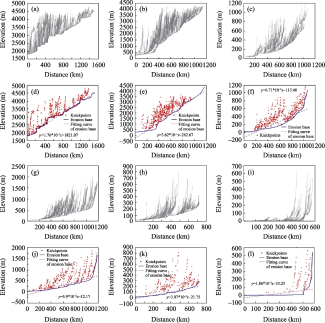
Figure 5 Sequence of the stream profile clusters in the Yangtze River. Stream profile clusters of the (a) Jinsha River Basin, (b) Minjiang River Basin, (c) Yuanjiang River Basin, (g) Hanshui River Basin, (h) Ganjiang River Basin, and (i) Lower Reaches of the Yangtze River Basin. Stream knickpoints and erosion base derived from stream profile clusters of the (d) Jinsha River Basin, (e) Minjiang River Basin, (f) Yuanjiang River Basin, (j) Hanshui River Basin, (k) Ganjiang River Basin, and (l) Lower Reaches of the Yangtze River Basin. |
Table 1 Statistics of the stream evolution index in sub-basins of the Yangtze River; basins were sorted from the upper reaches to the lower reaches |
| Basin name | Slope* | Mean | Median | Standard deviation |
|---|---|---|---|---|
| Jinsha River | 1.76*10‒1 | 0.33 | 0.33 | 0.12 |
| Minjiang River | 3.62*10‒1 | 0.29 | 0.28 | 0.10 |
| Yuanjiang River | 6.71*10‒2 | 0.21 | 0.22 | 0.08 |
| Hanshui River | 5.9*10‒2 | 0.22 | 0.20 | 0.07 |
| Ganjiang River | 3.07*10‒2 | 0.15 | 0.15 | 0.06 |
| Lower Reach | 1.86*10‒2 | 0.14 | 0.12 | 0.04 |
| Note: Slope* means the slope of the erosion base |
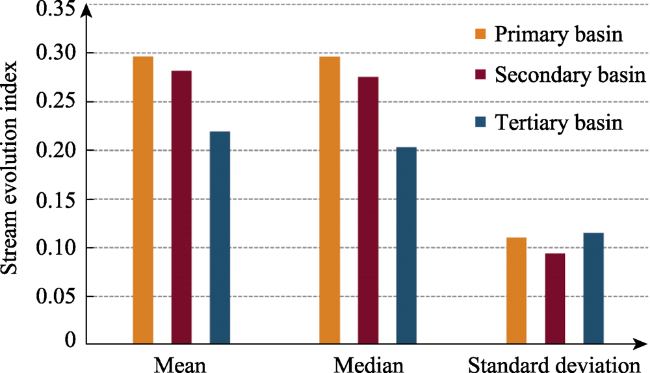
Table 2 Stream evolution index statistics under the constraints of stream network hierarchies |
| Basin hierarchy | Mean | Median | Standard deviation |
|---|---|---|---|
| Primary basin | 0.2966 | 0.2964 | 0.1105 |
| Secondary basin | 0.2817 | 0.2755 | 0.0941 |
| Tertiary basin | 0.2194 | 0.2033 | 0.1152 |
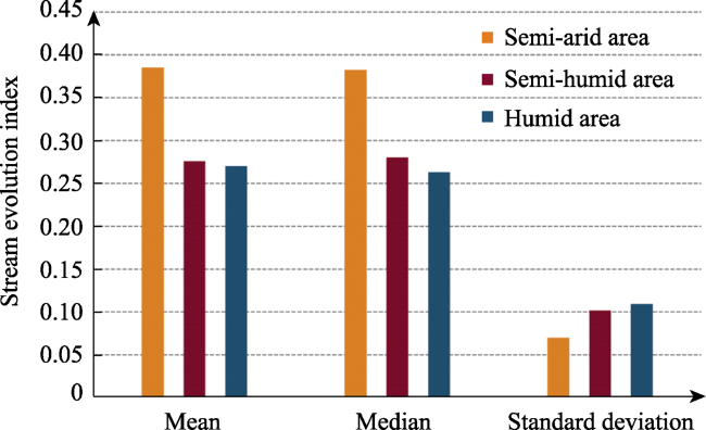
Table 3 Stream evolution index statistics under the constraints of precipitation |
| Precipitation | Mean | Median | Standard deviation |
|---|---|---|---|
| Semi-arid area | 0.3852 | 0.3826 | 0.0701 |
| Semi-humid area | 0.2762 | 0.2805 | 0.1018 |
| Humid area | 0.2702 | 0.2634 | 0.1092 |
Table 4 Stream evolution index statistics under the constraints of landform types |
| Landform type | Mean | Median | Standard deviation |
|---|---|---|---|
| Mountain | 0.2587 | 0.2514 | 0.0947 |
| Hill | 0.3066 | 0.3052 | 0.1223 |
| Plain | 0.1857 | 0.1673 | 0.1026 |
| [1] |
{{custom_citation.content}}
{{custom_citation.annotation}}
|
| [2] |
{{custom_citation.content}}
{{custom_citation.annotation}}
|
| [3] |
{{custom_citation.content}}
{{custom_citation.annotation}}
|
| [4] |
{{custom_citation.content}}
{{custom_citation.annotation}}
|
| [5] |
{{custom_citation.content}}
{{custom_citation.annotation}}
|
| [6] |
{{custom_citation.content}}
{{custom_citation.annotation}}
|
| [7] |
{{custom_citation.content}}
{{custom_citation.annotation}}
|
| [8] |
{{custom_citation.content}}
{{custom_citation.annotation}}
|
| [9] |
{{custom_citation.content}}
{{custom_citation.annotation}}
|
| [10] |
{{custom_citation.content}}
{{custom_citation.annotation}}
|
| [11] |
{{custom_citation.content}}
{{custom_citation.annotation}}
|
| [12] |
{{custom_citation.content}}
{{custom_citation.annotation}}
|
| [13] |
{{custom_citation.content}}
{{custom_citation.annotation}}
|
| [14] |
{{custom_citation.content}}
{{custom_citation.annotation}}
|
| [15] |
{{custom_citation.content}}
{{custom_citation.annotation}}
|
| [16] |
{{custom_citation.content}}
{{custom_citation.annotation}}
|
| [17] |
{{custom_citation.content}}
{{custom_citation.annotation}}
|
| [18] |
Bibliometrics was used to statistically analyze key zones within the Yangtze River Basin (YRB) funded by the National Natural Science Foundation of China (NSFC) and national ministries over the past 20 years. This study determined that funds that derived from national ministries have mainly focused on issues related to environmental pollution, ecological security, technological water regulations, and river basin ecosystems, which offer a better understanding of the national requirements and the scientific knowledge of the YRB in combination with data from the NSFC. Under a background of bolstering the construction of green ecological corridors in the economic belt of the YRB, this study proposes future conceptual watershed research initiatives in this region as a study objective by reinforcing the implementation of the Chinese Ecosystem Research Network (CERN) and by emphasizing the use of new technologies, new methods, and new concepts for the prospective design of frontier research under the perspective of geoscience and earth system science. This study promotes large-scale scientific field and research objectives based on big science and big data. {{custom_citation.content}}
{{custom_citation.annotation}}
|
| [19] |
{{custom_citation.content}}
{{custom_citation.annotation}}
|
| [20] |
{{custom_citation.content}}
{{custom_citation.annotation}}
|
| [21] |
{{custom_citation.content}}
{{custom_citation.annotation}}
|
| [22] |
{{custom_citation.content}}
{{custom_citation.annotation}}
|
| [23] |
{{custom_citation.content}}
{{custom_citation.annotation}}
|
| [24] |
{{custom_citation.content}}
{{custom_citation.annotation}}
|
| [25] |
{{custom_citation.content}}
{{custom_citation.annotation}}
|
| [26] |
{{custom_citation.content}}
{{custom_citation.annotation}}
|
| [27] |
{{custom_citation.content}}
{{custom_citation.annotation}}
|
| [28] |
{{custom_citation.content}}
{{custom_citation.annotation}}
|
| [29] |
{{custom_citation.content}}
{{custom_citation.annotation}}
|
| [30] |
{{custom_citation.content}}
{{custom_citation.annotation}}
|
| [31] |
{{custom_citation.content}}
{{custom_citation.annotation}}
|
| [32] |
{{custom_citation.content}}
{{custom_citation.annotation}}
|
| [33] |
{{custom_citation.content}}
{{custom_citation.annotation}}
|
| [34] |
{{custom_citation.content}}
{{custom_citation.annotation}}
|
| [35] |
{{custom_citation.content}}
{{custom_citation.annotation}}
|
| [36] |
{{custom_citation.content}}
{{custom_citation.annotation}}
|
| [37] |
{{custom_citation.content}}
{{custom_citation.annotation}}
|
| [38] |
{{custom_citation.content}}
{{custom_citation.annotation}}
|
| [39] |
{{custom_citation.content}}
{{custom_citation.annotation}}
|
| [40] |
{{custom_citation.content}}
{{custom_citation.annotation}}
|
| [41] |
{{custom_citation.content}}
{{custom_citation.annotation}}
|
| [42] |
{{custom_citation.content}}
{{custom_citation.annotation}}
|
| [43] |
{{custom_citation.content}}
{{custom_citation.annotation}}
|
| [44] |
{{custom_citation.content}}
{{custom_citation.annotation}}
|
| [45] |
{{custom_citation.content}}
{{custom_citation.annotation}}
|
| [46] |
{{custom_citation.content}}
{{custom_citation.annotation}}
|
| [47] |
{{custom_citation.content}}
{{custom_citation.annotation}}
|
| [48] |
{{custom_citation.content}}
{{custom_citation.annotation}}
|
| [49] |
{{custom_citation.content}}
{{custom_citation.annotation}}
|
| [50] |
{{custom_citation.content}}
{{custom_citation.annotation}}
|
| [51] |
{{custom_citation.content}}
{{custom_citation.annotation}}
|
| [52] |
Sonam,
{{custom_citation.content}}
{{custom_citation.annotation}}
|
| [53] |
{{custom_citation.content}}
{{custom_citation.annotation}}
|
| [54] |
{{custom_citation.content}}
{{custom_citation.annotation}}
|
| [55] |
{{custom_citation.content}}
{{custom_citation.annotation}}
|
| [56] |
{{custom_citation.content}}
{{custom_citation.annotation}}
|
| [57] |
{{custom_citation.content}}
{{custom_citation.annotation}}
|
| [58] |
{{custom_citation.content}}
{{custom_citation.annotation}}
|
| [59] |
{{custom_citation.content}}
{{custom_citation.annotation}}
|
| [60] |
{{custom_citation.content}}
{{custom_citation.annotation}}
|
| [61] |
{{custom_citation.content}}
{{custom_citation.annotation}}
|
| [62] |
{{custom_citation.content}}
{{custom_citation.annotation}}
|
| [63] |
{{custom_citation.content}}
{{custom_citation.annotation}}
|
| [64] |
{{custom_citation.content}}
{{custom_citation.annotation}}
|
| [65] |
{{custom_citation.content}}
{{custom_citation.annotation}}
|
| [66] |
{{custom_citation.content}}
{{custom_citation.annotation}}
|
| [67] |
{{custom_citation.content}}
{{custom_citation.annotation}}
|
| [68] |
{{custom_citation.content}}
{{custom_citation.annotation}}
|
| [69] |
{{custom_citation.content}}
{{custom_citation.annotation}}
|
| [70] |
{{custom_citation.content}}
{{custom_citation.annotation}}
|
| [71] |
{{custom_citation.content}}
{{custom_citation.annotation}}
|
| [72] |
{{custom_citation.content}}
{{custom_citation.annotation}}
|
| [73] |
The Tongtian section of the Yangtze River is located in ??the central part of the Tibetan Plateau where the neotectonic activity is illustrated by frequent earthquakes, such as the Yushu earthquake (Ms 7.1) on April 14, 2010. The study area is situated in the upstream parts of the Yellow River Basin, the Yalong River and Lanchang River catchments. In this region the tributaries have developed an inverted drainage pattern with nearly right-angle intersection. Based on terrain and areal river system analysis, including geomorphic index calculation, this paper discusses the evolution of the drainage pattern related to the neotectonic movements in this area. Two groups of valleys are distinguished with NW-SE and SW-NE directions, respectively. The NW-trending rivers are unfit channels with gentle slope and large width, while most of the SW-trending rivers are canyons with steep slope and V-shaped transect. It turns out that the steepness index (ks) in the southeastern part of the Tongtian River is higher than that in the Duocai-Ningqia basin, Dengailong basin, Yequ basin and the southwestern part of the Batang basin. The stream length-gradient index (SL) is similar in the whole catchment, but the SL values in the inverted channels and nearly right-angle intersecting channels are abnormal. The value of the hypsometric integral (HI) is over 0.45 at both sides of the Tongtian River, while it is 0.15-0.45 in the Duocai-Ningqia basin, Dengailong basin, Yequ basin and Batang basin. The values and distribution of geomorphic indexes indicate that the pre-existing SE-trending parallel-drainage pattern turned to an inverted-drainage pattern as a result of strike-slip faulting. Dangjiang, Lixing, Longbao and the northeastern part of the Shanglaxiu regions became pull-apart basins, while the tributaries of the Tongtian River in the northeast eroded dramatically headward as a result of the uplift of the NE-trending thrust, and finally captured the former SE-trending channels. {{custom_citation.content}}
{{custom_citation.annotation}}
|
| [74] |
{{custom_citation.content}}
{{custom_citation.annotation}}
|
| [75] |
{{custom_citation.content}}
{{custom_citation.annotation}}
|
| [76] |
{{custom_citation.content}}
{{custom_citation.annotation}}
|
| [77] |
{{custom_citation.content}}
{{custom_citation.annotation}}
|
| [78] |
{{custom_citation.content}}
{{custom_citation.annotation}}
|
| [79] |
{{custom_citation.content}}
{{custom_citation.annotation}}
|
| [80] |
{{custom_citation.content}}
{{custom_citation.annotation}}
|
| [81] |
{{custom_citation.content}}
{{custom_citation.annotation}}
|
| {{custom_ref.label}} |
{{custom_citation.content}}
{{custom_citation.annotation}}
|


 PDF(12133 KB)
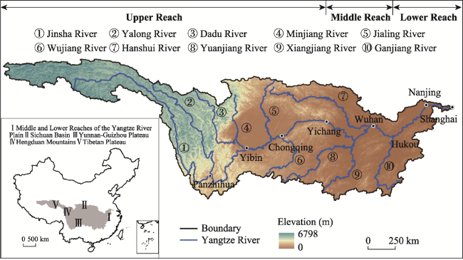
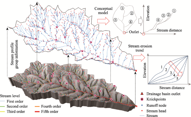
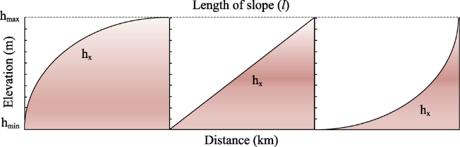
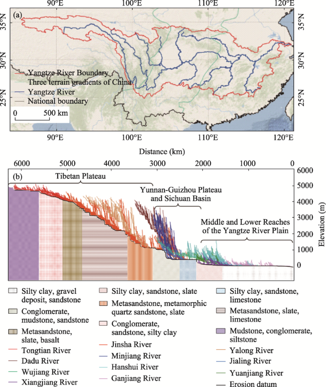
 Figure 1 The Yangtze River Basin and its stream networkFigure 2 Conceptual model of the stream profile cluster approachFigure 3 Schematic for calculating the stream evolution index based on three types of slopes (concave, convex and straight slopes*The upper half of the rectangle is what the stream has eroded away. The lower half of the rectangle is what the river has not yet eroded away.Figure 4 (a) Map of the Yangtze River Basin; (b) stream profile clusters of the Yangtze River Basin and bedrock information under the erosion base in different basinsFigure 5 Sequence of the stream profile clusters in the Yangtze River. Stream profile clusters of the (a) Jinsha River Basin, (b) Minjiang River Basin, (c) Yuanjiang River Basin, (g) Hanshui River Basin, (h) Ganjiang River Basin, and (i) Lower Reaches of the Yangtze River Basin. Stream knickpoints and erosion base derived from stream profile clusters of the (d) Jinsha River Basin, (e) Minjiang River Basin, (f) Yuanjiang River Basin, (j) Hanshui River Basin, (k) Ganjiang River Basin, and (l) Lower Reaches of the Yangtze River Basin.
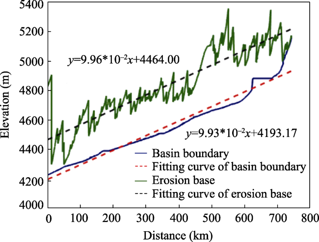
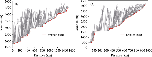
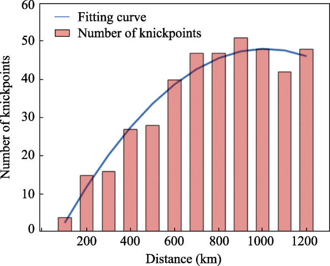
 Table 1 Statistics of the stream evolution index in sub-basins of the Yangtze River; basins were sorted from the upper reaches to the lower reachesFigure 6 The diagram of the basin boundary line and erosion base line of the Tongtian River BasinFigure 7 Stream profile clusters of the (a) Jinsha River Basin and (b) Dadu River BasinFigure 8 Knickpoints distribution derived from stream profile clusters of the Hanshui River BasinFigure 9 Stream evolution index constrained by basin hierarchiesTable 2 Stream evolution index statistics under the constraints of stream network hierarchiesFigure 10 Stream evolution index constrained by precipitationTable 3 Stream evolution index statistics under the constraints of precipitationFigure 11 Stream evolution index constrained by geomorphological typesTable 4 Stream evolution index statistics under the constraints of landform types
/
| 〈 |
|
〉 |


 AI Summary

