Research Articles

Spatiotemporal mismatch of land use functions and land use efficiencies and their influencing factors: A case study in the Middle Reaches of the Yangtze River, China

  • GAO Yunxiao ,
  • WANG Zhanqi , * ,
  • CHAI Ji ,
  • ZHANG Hongwei
Expand
  • School of Public Administration, China University of Geosciences, Wuhan 430074, China
*Wang Zhanqi (1965-), PhD and Professor, specialized in land economy and management, and territorial spatial planning. E-mail:

Gao Yunxiao (1992-), PhD, specialized in land use evaluation and territorial spatial planning. E-mail:

Received date: 2022-10-01

  Accepted date: 2023-11-07

  Online published: 2024-01-08

Supported by

Key Project of the National Social Science Foundation of China(23AZD058)

National Natural Science Foundation of China(72004209)

Abstract

Identification of the spatial mismatch between land use functions (LUFs) and land use efficiencies (LUEs) is essential to regional land use policies. However, previous studies about LUF-LUE mismatch and its driving factors have been insufficient. In this study, we explored the spatiotemporal mismatch of LUFs and LUEs and their influencing factors from 2000 to 2018 in the Middle Reaches of the Yangtze River (MRYR). Specifically, we used Spearman correlation analysis to reveal the trade-off relationship between LUFs and LUEs and determine the direction of the influencing factors on the LUF-LUE mismatch, adopted spatial mismatch analysis to measure the imbalance between LUFs and LUEs, and used the geographical detector model to analyze the factors influencing this spatial mismatch. The results showed that production function (PDF), living function (LVF), ecological function (ELF), agricultural production efficiency (APE), urban construction efficiency (UCE), and ecological services efficiency (ESE) all displayed significant spatial heterogeneity. The high trade-off areas were widely distributed and long-lasting in agricultural space and urban space, while gradually decreasing in ecological space. Wuhan and Changsha showed high spatial mismatch coefficients in urban space, but low spatial mismatch coefficients in agricultural space. Hunan generally presented high spatial mismatch coefficients in ecological space. Furthermore, the interaction of the proportion of cultivated area and transportation accessibility exacerbated the mismatch in agricultural space. The interaction effects of capital investment and technology innovation with other factors have the most intense impact on the mismatch in urban space. The internal factor for cultivated area interacts with other external factors to drastically affect ecological spatial mismatch.

Cite this article

GAO Yunxiao , WANG Zhanqi , CHAI Ji , ZHANG Hongwei . Spatiotemporal mismatch of land use functions and land use efficiencies and their influencing factors: A case study in the Middle Reaches of the Yangtze River, China[J]. Journal of Geographical Sciences, 2024 , 34(1) : 62 -88 . DOI: 10.1007/s11442-024-2195-1

1 Introduction

With the continuous industrialization, urbanization, and agricultural modernization, and the increasing intensity of land space development, the contradiction between the development of socio-economy and the support of resources and the environment is increasingly prominent (Turner et al., 2007; Fan et al., 2021; Zhang and Wang, 2022). These processes run counter to the protection of natural resources (Ng et al., 2011; Song et al., 2015; Long et al., 2018), and threaten their sustainable development (Wiggering et al., 2006; Yin et al., 2023). Dealing with the conflict between development and protection is now the core planning issue. Differentiated management based on land use functions (LUFs) is considered an effective means to solve this dilemma (Liu et al., 2018a; Meng et al., 2019; Fan et al., 2023; Gao et al., 2023a). However, relying only on resource endowments and functional supply for management has certain limitations. When resources are limited, achieving higher land use efficiencies (LUEs) is crucial to high-quality regional development (Lu, 2018; Yin et al., 2022; He et al., 2023). However, it is not clear whether there is a match between the background characteristics of the region as reflected in the LUFs and the actual LUEs of its use.
LUFs describe the provision of private or public goods and services to people through different land uses (Wiggering et al., 2006), and reflect most directly the conditions for developing regional land resources and the environment. At present, LUFs are usually classified in two ways: by land space, which includes production function (PDF), living function (LVF), and ecology function (ELF) (Liu et al., 2018b; Zhu et al., 2021; Ji et al., 2023; Qu et al., 2023), or by economic, social and ecological functions (Meng et al., 2019; Zhang et al., 2022a; Gao et al., 2023b). This study chooses the former because it can effectively guide land use management under China’s spatial planning system. Based on the trade-offs relationship within ecological services (He et al., 2020; Liang et al., 2021; Chen et al., 2022), scholars focus on the trade-offs and synergies relationship within LUFs, which are calculated using a range of statistical methods including correlation analysis (Ma et al., 2020a; Yang et al., 2021a), hot spot analysis (Lyu et al., 2022), Moran’s index (Liu et al., 2021), root mean square error (Cueva et al., 2022), etc. And the results are applied to the land use management (Liu et al., 2021; Zhang and Gu, 2022). However, current research on fusing LUFs with LUEs is limited.
The LUEs are calculated based on estimated maximum outputs and minimum factor inputs (Jin et al., 2022), and reflect the level at which regional resources and environment are utilized. Research has focused on specific types of LUEs, including urban LUE (Chen et al., 2016; Liu et al., 2018a; Gao et al., 2020), cultivated LUE (Yang et al., 2021b; Guo et al., 2023; Xiang et al., 2023), and extended to land use ecological efficiency on these bases (Deng and Gibson, 2019; Hou et al., 2019; Ke et al., 2023). These researchers have analyzed the driving factors and influencing mechanisms of efficiency (Xie et al., 2018; Yu et al., 2019). Some scholars have also tried to couple space function and efficiency (Liu et al., 2020). LUE is a key indicator of developmental level, reflecting the actual utilization of regional resources. If the functions and efficiencies of the area are matched, the land use functions are fully utilized. However, the characteristics of the match between the LUFs and the LUEs and the factors influencing the match are not yet clear.
The Chinese government proposed a territory spatial planning system, focusing on territory spatial control and planning (Zhang et al., 2014). This system replaces the previous focus on production with an approach that coordinates production, living, and ecological spaces (Liu et al., 2018a; Zhang et al., 2022b). Corresponding to the classification system of the territory space, in order to reveal the matching pattern of land use functions and efficiency and analyze its influencing factors, we established an index system of LUFs (including production function (PDF), living function (LVF), and ecological function (ELF), and we used a slack-based model (SBM) to calculate agricultural production efficiency (APE), urban construction efficiency (UCE), and ecological service efficiency (ESE) of land space utilization. We calculated the mismatch between LUFs and LUEs and analyzed the trade-off states. Introduced the geographical detector to analyze the interactive effects of regional background and external factors on mismatches.

2 Study area and data

2.1 Study area

As Figure 1 shows, the MRYR (20°09'-33°20'N, 108°21'-118°28'E) is composed of Hubei, Hunan, and Jiangxi provinces, whose three provincial capitals are Wuhan, Changsha, and Nanchang, respectively. In addition, there are three major urban agglomerations in the district: Wuhan Metropolitan Circle, Poyang Lake City Cluster, and Changsha-Zhuzhou- Xiangtan Metropolitan Circle. The total land area of the MRYR is 564,700 km2, accounting for 5.88% of China’s total land area. The region is basin-shaped, with flat terrain in the center, surface runoff and lakes, and mountains in the surrounding area. The region’s GDP was 8.94 trillion yuan, accounting for 29.12% of the Yangtze River Economic Belt, while urbanization reached 54.7% (from a level of 18% in 1995) in 2018. The MRYR has an important strategic position in China’s economic and social development. However, rapid economic development has reduced the area of arable land and ecological land and polluted the environment, severely restricting regional sustainable development.
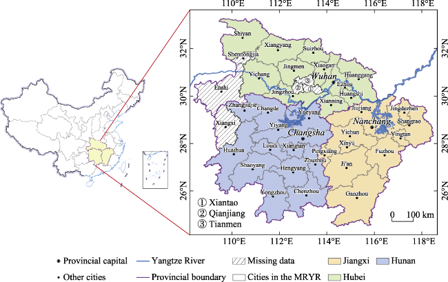
Figure 1 Location of the Middle Reaches of the Yangtze River, China

Note: Map Content Approval Number: GS (2019)1831, no modification

2.2 Data source and processing

The present study used geographic, meteorological, and socioeconomic data, as well as land use/land cover data, to evaluate each LUF (Table 1). The region’s annual net primary productivity (NPP) and normalized difference vegetation index (NDVI) were calculated using the ArcGIS 10.6 spatial analysis tool. Kriging interpolation was used to obtain a map of total solar radiation, sunshine duration, temperature, and precipitation. Land use was divided into cultivation, orchard, forest, grassland, urban and rural construction, transportation, water, and unused land. Missing data were inferred using linear regression. Finally, panel data from 2000 to 2018 were compiled to calculate the corresponding LUFs and LUEs metrics.
Table 1 Data categories and sources
Data category Data description Data source
Geographic data NPP; Raster; 1 km×1 km Monthly NPP 1 km Raster Dataset of China’s Terrestrial Ecosystems
(https://doi.org/10.3974/geodb.2019.03.02.V1)
NDVI; Raster; 1 km×1 km Global GIMMS NDVI3g v1 dataset (http://data.tpdc.ac.cn)
Meteorological data Total solar radiation, sunshine duration, temperature, and precipitation; Sites National Meteorological Information Center (http://data.cma.cn/), and Local Meteorological Administration
Land use/ land cover data Land use/Land cover database; Raster;
30 m×30 m
Data Center for Resources and Environmental Sciences, Chinese Academy of Sciences (RESDC) (http://www.resdc.cn/)
Socio-
economic data
Output value of primary industry secondary industry, tertiary industry; Statistics; The basic unit is the city China Regional Economic Statistical Yearbook, China Rural Statistical Yearbook (https://data.cnki.net/), and Local Statistical Yearbook
Population, Employment, Facilities. Electricity consumption, Fiscal expenditure, Industry pollution, Energy consumption; Statistics; The basic unit is the city China Regional Economic Statistical Yearbook, China Rural Statistical Yearbook (https://data.cnki.net/), and Local Statistical Yearbook

3 Research framework and methods

3.1 Research framework

Optimal land use planning requires regionally dominant functions to be incorporated into the decision-making process. Local government must also consider how land resources are used in the actual development process to ensure that the development and utilization of AGS, UBS, and ELS are maximally effective. To accomplish this and support spatial management in the MRYR, we developed a regional LUF-LUE mismatch analysis framework. In line with China’s current planning system, this study divides land space into AGS, UBS, and ELS, with the corresponding categories shown in Figure 2. Among them, AGS corresponds to PDF and APE. UBS corresponds to LVF and UCE. ELS corresponds to ELF and ESE. LUFs represents regional development conditions, and LUEs reflects the level of resource utilization. The matching and coordination of the two jointly promote the high-quality development of land space.
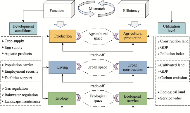
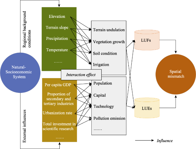
Figure 2 Theoretical framework

3.2 Measurement and evaluation of LUFs

Based on the theoretical framework shown in Figure 2, we build an index system of LUFs, including three primary functions and nine sub-functions (Table 2). PDF refers to the function of AGS to provide agricultural and sideline products to protect human life, including three sub-functions of crop supply, poultry and egg supply, and aquatic product supply. They are calculated by using crop yield, poultry and egg yield, and aquatic product yield, respectively. LVF denotes the provision of social security and living services for human beings, including three sub-functions of population carrier, employment security, and facilities support. We use population density, employed population in urban, and number of medical beds to calculate them specifically. ELF refers to the ability to provide ecological services and improve the ecological environment through the regulation of gas and water, ecological conservation, etc. ELF also includes three sub-functions, namely gas regulation, water regulation, and ecological conservation. We use carbon sequestration, water yield, and vegetation coverage index to represent them.
Table 2 Evaluation index system and calculation method of LUFs
Primary functions Sub-functions (Weight) Indicators Formula Key references
Production
function
(PDF)
Crop supply (0.441) Crop yield G Y i = G Y i j / S (Fan et al., 2021)
Poultry and egg supply (0.323) Poultry and egg yield P E i = P E i j / S (Fan et al., 2021)
Aquatic product supply (0.237) Aquatic product yield A P i = A P i j (Fan et al., 2021)
Living
function
(LVF)
Population carrier (0.449) Population density P D i = P i / S i (Ren et al., 2021)
Employment security (0.308) Employed population in urban E M i = E M i j / S i (Liu et al., 2021)
Transport support (0.243) Traffic coverage level T C i = k = 1 n w k × r k , i / A i (Li et al., 2023)
Ecological
function
(ELF)
Gas regulation (0.270) Carbon sequestration C S = N × β × N P P (Zhu et al., 2021)
Water regulation (0.411) Water yield Y i= Y i Y i Y i Y i.
Y i Y i
(Zhang et al., 2001;
Zhang et al., 2004)
Ecological conservation (0.319) Vegetation coverage index C i = N D V I N D V I s N D V I v N D V I s (Meng et al., 2019)
The calculation formula and key references of each index are shown in Table 2. We obtained the weight of each indicator through the entropy weight method (Table 2). The indicators were normalized by min-max normalization so that the value range of each indicator was from zero to one. Then, the comprehensive evaluation method was adopted. The following formula is used:
F i = j = 1 n I i j × w j
where Fi represents the value of LUFi; Iij is the value of indicator j in city i, and wj is the weight of indicator j.

3.3 Measurement and evaluation of Es

3.3.1 Variables used to measure the LUEs

Combining actual land utilization in the MRYR and referring to the literature, we have selected five variables each for APE and ESE, and six variables for UCE. The definition and quantification methods of each index are shown in Table 3. For APE, the input factors were crop-sown area, primary industry employees, agricultural capital stock, and total power of agricultural machinery. These reflect the levels of land, labor, capital, and technology in the agricultural production process. Agricultural GDP and carbon emissions were the expected and undesired outputs, respectively. Although some carbon emissions are produced via high-efficiency agricultural production, these should be minimized while GDP should be maximized. For UCE, we selected urban construction land, fiscal expenditure, and secondary and tertiary industry employee numbers as input factors. Non-agricultural GDP was regarded as desirable, and industrial waste and sulfur dioxide production were regarded as the undesirable output. For ESE, we selected ecological land and energy consumption per unit of GDP as land and energy input elements; ecological service value and carbon sink capacity were the desirable outputs. Thus, the LUE index system incorporates the resource efficiency of AGS, UBS, and ELS into a comparable framework that helps to reveal the LUF-LUE relationships in land use.
Table 3 Evaluation index system and calculation method of LUEs
Classification Indicators of inputs and outputs Formula Key references
Agricultural production
efficiency
(APE)
Input Sown area of crops S A C i = S A C i j (Kuang et al., 2020)
Employees in the primary industry E P I i = E P I i j (Kuang et al., 2020)
Agricultural capital stock A C S i = A C S i j (Yang et al., 2021a)
Agricultural machinery power A M P i = A M P i j (Kuang et al., 2020)
Desirable output Agricultural GDP A G D P i = A G D P i j (Kuang et al., 2020)
Undesirable output Carbon emissions A C E i = V A C E i j × γ (Kuang et al., 2020)
Urban
construction efficiency (UCE)
Input Urban construction land U L U C C i = S U L U T i j (Song et al., 2022)
Fiscal expenditure F E i = F E I i j. (Song et al., 2022)
Employees in the secondary and tertiary industries E S T i = E S T i j (Lu et al., 2018)
Desirable output Non-agricultural GDP N A G D P i = N A G D P i j (Lu et al., 2018)
Undesirable output Industrial waste I W i = I W i j (Lu et al., 2018)
Indusial sulfur dioxide I S D i = I S D i j (Xue et al., 2022)
Ecological
service
efficiency
(ESE)
Input Ecological land E L i = E L i j (Jin et al., 2022)
Energy consumption per unit of GDP E C P G i = E C i / G D P i j. (Cheng et al., 2014)
Desirable output Ecolical service value E S V i = S E S V i j × β (Xie et al., 2015a; Xie et al., 2015b)
Carbon sink E C S i = S E C S i j × δ (Sun et al., 2015)

3.3.2 SBM-undesirable model

The data envelopment analysis (DEA) model, initially proposed by Charnes et al. (1978), has been widely employed as a decision-making instrument for measuring the efficiency of resource use (Chen et al., 2016; Gao et al., 2020). Efficiency measurement with the traditional DEA model is primarily based on the radial and angular levels of homogeneous units to minimize the input or maximize the output. However, the evaluation process largely ignores undesirable outputs. To ameliorate this problem, the SBM model was developed by Tone (2010). The model can measure efficiency while incorporating both desirable and undesirable outputs and has recently entered widespread use (Yu et al., 2019; Xie et al., 2021; Song et al., 2022).
m i n β = 1 m i = 1 n x / x i 0 1 r 1 + r 2 s = 1 r 1 y d / y s 0 d + q = 1 r 2 y u / y q 0 u
s . t . x j = 1 , 0 n x i j λ j ; y d j = 1 , 0 n y s j d λ j
y d j = 1 , 0 n y q j d λ j ; x x 0 ; y d y 0 d ; y u y 0 u
λ j 0 , i = 1 , 2 , . . . , m ; j = 1 , 2 , . . . , n , j 0
s = 1 , 2 , . . . , r 1 ; q = 1 , 2 , . . . , r 2
where β represents the LUE value and the measurement indexes include input index (m), desirable output index r1, and undesirable output index r2. x, yd, and yu denote the input, desirable output matrix, and undesirable output matrix, respectively. λ represents the weight vector, and n represents the amount of evaluation units.

3.4 Spatial mismatch analysis

To quantify the spatial imbalance between LUFs and LUEs and their spatial heterogeneity, we refer to relevant studies on the mismatch between grain production and farmland resources and introduced the spatial mismatch index (SMI). The formula is as follows:
S M I i = E i i = 1 n E i F i i = 1 n F i × 100
where SMIi is the spatial mismatch coefficient between LUF and LUE of the i-th city, Ei and Fi are LUE and LUF of the i-th city, respectively. When SMIi > 0, it shows that the location quotient of LUE is greater than that of LUF, and the achievement level of LUF in city i is higher than that in other cities, which reflects a higher land use functional efficiency (Liu et al., 2023) in city i; Conversely, when SMIi < 0, it shows that the location quotient of LUE is less than that of LUF, and the achievement level of LUF in city i is lower than that in other cities, which reflects a lower land use functional efficiency in city i, relatively (Li et al., 2017; Chai et al., 2019; Chen et al., 2023). Furthermore, the spatial mismatch coefficient was classified by natural breakpoint method (Table 4).
Table 4 Classification of spatial mismatch coefficients
SMI Spatial mismatch (Low efficiency) Spatial match Spatial mismatch (High efficiency)
PDF-APE mismatch <-0.75 -0.75-1.00 >1.00
LVF-UCE mismatch <-1.78 -1.78-1.13 >1.13
ELF-ESE mismatch <-0.94 ‒0.94-1.03 >1.03

3.5 Trade-offs and synergies analysis

Previous studies have confirmed that both LUFs and LUEs exhibit complicated trade-offs and synergies relationships (Fan et al., 2022; Liu et al., 2023b). How are these relationships among three LUF-LUE mismatches varied in time and space? In answer to this question, we introduced the Bivariate Local Moran’s I model (Liu et al., 2021), which can effectively identify spatial agglomeration characteristics and anomalies, and reveal spatial interaction relationships between the research objects. The Bivariate Local Moran’s I model can be written as:
I i = Z i / i Z i 2 n j w i j y i y ¯
where
Z i = x i x ¯
, xi and yi are the different LUF-LUE mismatch in cities i and j, respectively.
x ¯
and
y ¯
are the mean values of different LUF-LUE mismatch values of all cities i and j, respectively. n is the number of cities, and wij is the spatial adjacent weight matrix between each city i and j. In general, the spatial clusters can be divided into High-High clustering, High-Low clustering, Low-High clustering, and Low-Low clustering. The correlation of LUF-LUE mismatch representing High-High clustering or Low-Low clustering is defined as the synergy relationship. The correlation of LUF-LUE mismatch representing High-Low clustering or Low-High clustering is defined as the trade-off relationship.

3.6 Influencing factor analysis

3.6.1 Selection of LUF-LUE mismatch influencing factor indices

The mismatch of LUFs and LUEs is the result of complex land use processes and diverse human activities acting together (Long et al., 2018; Chai et al., 2019; Li et al., 2020). Based on the previous studies (Peng et al., 2017; Ma et al., 2020b; Zhang et al., 2020; Xu and Zhang, 2021), and considering the characteristics of the study area and the availability of data, we selected 13 influencing factors from regional background conditions and external influences perspectives to detect the mechanism of the mismatch of LUFs and LUEs (Table 5).
Table 5 Index system of influencing factors
Dimension Influencing factors Unit Quantification method/Sources
Regional background conditions Elevation (Elve) m DEM
Terrain slope (Slope) ° Slope Tool in ArcGIS
Annual precipitation (AP) mm China Meteorological Administration
Annual temperature (AT)
Traffic accessibility (TA) km/km2 Road length/total area
Distance to water area (Dwater) m Near Tool in ArcGIS
Land reclamation rate (LRR) % Cultivated area/total area
External influences Per capita GDP (PCGDP) yuan/pop. China City Statistical Yearbook
Proportion of secondary and tertiary industries (PSTI) %
Urbanization rate (UR) %
Proportion of rural population (PRP) %
Total investment in scientific research (TISR) 104 yuan
Sewage treatment rate (STR) %
Specifically, regional background conditions are the prerequisites of the variation in LUF-LUE mismatch, including elevation (Elve), terrain slope (Slope), annual precipitation (AP), annual temperature (AT), traffic accessibility (TA), distance to water area (Dwater), and land reclamation rate (LRR). Elve and Slope were extracted from the digital elevation model (DEM) using different spatial analysis tools in ArcGIS. AP and AT were spatially interpolated using multiple meteorological stations (from the China Meteorological Administration) distributed over the study area. TA refers to the ratio of the length of railways, highways, and national highways to the total area. Dwater was the spatial distance to the nearest water area calculated using Near Tool in ArcGIS. Moreover, LRR represented the development and utilization degree of regional cultivated land resources, which can be obtained by dividing the regional cultivated area by the total area.
In addition to regional background conditions, external influences have an important impact on LUF-LUE mismatch. We selected six influencing factors from external influences, including per capita GDP (PCGDP), proportion of secondary and tertiary industries (PSTI), urbanization rate (UR), proportion of rural population (PRP), total investment in scientific research (TISR), and sewage treatment rate (STR). PCGDP and PSTI reflected the level of economic development of a city. UR and PRP expressed the type of population composition of a city. TISR played an important role in innovating scientific and technological levels and improving territorial space utilization efficiency. STR was characterized by the impact of ecological and environmental protection. These indices can be obtained through the China City Statistical Yearbook.

3.6.2 Geographical detector model

The geographical detector model is a statistical method for detecting the associations between the explanatory variables and the dependent variables by analyzing the spatial distribution consistency (Fan et al., 2022). It has been widely used to test the mechanism affecting LUF and LUE in recent years (Liu et al., 2021; Cui et al., 2023). The model is composed of four parts: the factor detector, the risk detector, the ecological detector, and the interaction detector. In this study, the factor detector and the interaction detector were adopted to explore the driving mechanisms for the mismatch of LUFs and LUEs. The q value is used to quantify the impact of the factors in the factor detector model, which can be expressed as:
q = 1 1 N σ 2 i = 1 n N i σ i 2 = 1 S S W S S T
where q is the determinant power, N is the number of samples in the entire region, Ni is the number of samples in layer i,
σ 2
is the global variance in the entire region Y,
σ i 2
is the variance in layer i, SSW and SST are the sum of squares and the total sum of squares, respectively. The q value is [0,1]. The larger the q value, the stronger the explanatory power of the independent variable X to Y.
The purpose of interactive detection is to examine whether two factors have independent effects on the dependent variables, or whether they have enhanced or weakened effects after interacting. The interactive relationship can be divided into five categories, shown in Table 6. Moreover, the Spearman correlation coefficient (ρ) was adopted to determine the direction of the influencing factors on the mismatch of LUFs and LUEs.
Table 6 The interactive categories of two factors
Interaction relationship Interaction
q X 1 X 2 < M i n q X 1 , q X 2 Weak; nonlinear
M i n q X 1 , q X 2 < q X 1 X 2 < M a x q X 1 , q X 2 Weak; univariate
q X 1 X 2 > M a x q X 1 , q X 2 Enhanced; bivariate
q X 1 X 2 = q X 1 + q X 2 Independent
q X 1 X 2 > q X 1 + q X 2 Enhanced; nonlinear

4 Results

4.1 Spatiotemporal changes of LUFs and LUEs in the MRYR from 2000 to 2018

The PDF, LVF, and ELF of different cities in the MRYR showed significant spatial heterogeneity (Figure 3). All three provinces had a small number of cities that presented high values of PDF. Cities with higher LVF values were mainly distributed in the three capitals of Wuhan, Changsha, and Nanchang, whose scores for LVF were significantly higher than other cities. The values for ELF in the MRYR were obviously higher in the south and lower in the north, and higher for Jiangxi and Hunan than for Hubei.
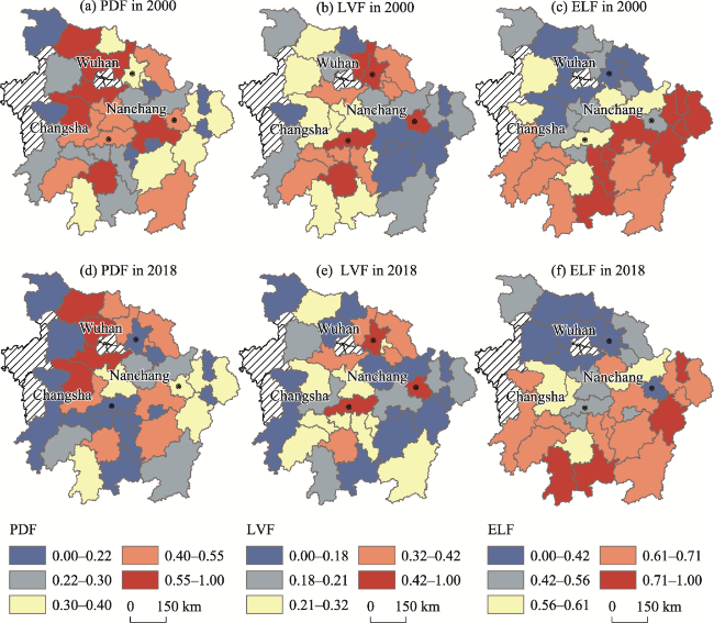
Figure 3 Spatiotemporal changes of LUFs in the Middle Reaches of the Yangtze River from 2000 to 2018
From 2000 to 2018, the regional APE and UCE increased significantly, while ESE decreased (Figure 4). In 2018, the areas with high APE values were primarily located in Jiangxi and central Hubei. The high UCE values areas were distributed as strips in the center of the region. The ESE values grew weaker with increasing distance from the core of Wuhan, Changsha, and Nanchang.
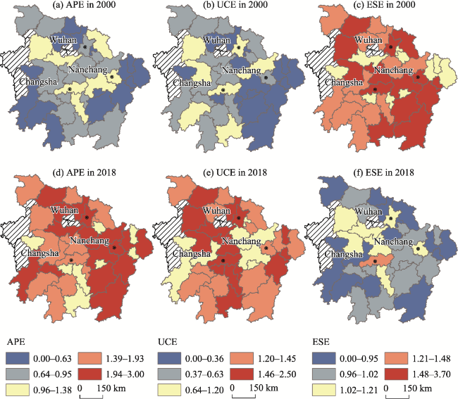
Figure 4 Spatiotemporal changes of LUEs in the Middle Reaches of the Yangtze River from 2000 to 2018

4.2 Spatial mismatch analysis of LUFs and LUEs

The SMI was adopted to quantify the spatial mismatch characteristics between LUFs and LUEs, and the spatial mismatch coefficient was classified by natural breaks classification (Figures 5-7). As for PDF-APE mismatch, the spatial mismatch characteristics were constantly changing during the study period (Figure 5). Cities with higher production functional efficiency mainly appeared in Wuhan, Shiyan, Yichang, Huangshi (Hubei), Changsha, Zhangjiajie, Loudi, Xiangtan, Zhuzhou (Hunan), and Pingxiang, Xinyu, Yingtan, Jingdezhen (Jiangxi). On the contrary, multiple cities (Xiangyang, Jingmen, Jingzhou, Changde, and Huanggang) showed an inefficient spatial mismatch. It was worth noting that as provincial capitals, Wuhan and Changsha presented the highest production functional efficiency, while Nanchang had a lower production functional efficiency. Moreover, cities with matching characteristics accounted for about a quarter of the total cities.
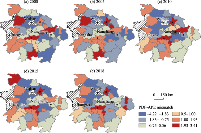
Figure 5 Spatial mismatch coefficient between PDF and APE in the Middle Reaches of the Yangtze River from 2000 to 2018
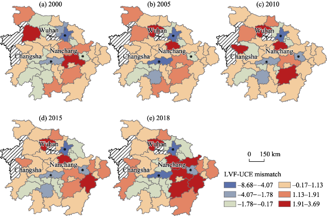
Figure 6 Spatial mismatch coefficient between LVF and UCE in the Middle Reaches of the Yangtze River from 2000 to 2018
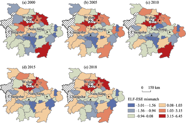
Figure 7 Spatial mismatch coefficient between ELF and ESE in the Middle Reaches of the Yangtze River from 2000 to 2018
As for LVF-UCE mismatch, most cities showed matching characteristics during the study period (Figure 6). Cities with high living functional efficiency mainly appeared in Jingmen, Xianning, Zhangjiajie, Yichun, and Ji’an. Over time, the number of cities with high living functional efficiency has increased, reaching eleven in 2018. Unexpectedly, Wuhan and Changsha have been in an inefficient spatial mismatch during the study period, and over time, Nanchang also reduced to low production functional efficiency. Moreover, some cities were constantly varying. For example, Jiujiang in Jiangxi changed from spatial mismatch to match, and then to spatial mismatch again.
As for ELF-ESE mismatch, the spatial mismatch characteristics were basically consistent from 2000 to 2018 (Figure 7). Cities with high ecological functional efficiency were mainly distributed around Wuhan, including Huanggang, Ezhou, Xiaogan, Jingzhou, and so on. Contrastingly, cities around Changsha and Nanchang exhibited an inefficient spatial mismatch. It was worth noting that Ganzhou in Jiangxi showed high ecological functional efficiency, while its surrounding cities were spatial match or inefficient spatial mismatch. Moreover, Xianning in Hubei changed from spatial match to mismatch, and then to spatial match again.

4.3 Trade-offs and synergies analysis among the mismatch of LUFs and LUEs

The trade-offs and synergies differed considerably among different LUF-LUE mismatch and varied over time (Figure 8). The relationship between PDF-APE mismatch and LVF-UCE mismatch in most cities was not significant during 2000-2018. The synergy relationship mainly occurred in Ezhou, Huanggang in Hubei, and Xinyu in Hunan, while the trade-offs appeared in Xiangyang and Nanchang during the study period. Moreover, there was a risk of a trade-off relationship between PDF-APE mismatch and LVF-UCE mismatch in Xianning and Ji’an.
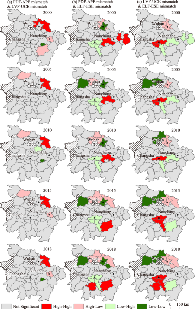
Figure 8 Spatial distribution of trade-offs and synergies among the mismatch of LUFs and LUEs in the Middle Reaches of the Yangtze River from 2000 to 2018
For PDF-APE mismatch and ELF-ESE mismatch, the distribution of the synergy relationship gradually shifted from Yichun to Ji’an during 2000-2018, while Wuhan maintained the synergy relationship all the time. In addition, Yichang became a member of the synergy relationship after 2015. Contrastingly, the trade-off relationship was concentrated in the cities around Wuhan and Changsha. The area of the trade-off relationship has continued to grow over time.
In terms of LVF-UCE mismatch and ELF-ESE mismatch, the number of cities in the synergy relationship was gradually increasing during the study period. Besides, they were mainly distributed in northern Hubei and around Changsha. Moreover, the area of the trade-off relationship was concentrated in the cities around Wuhan, and the range was also gradually increasing. As for the other trade-off area, it was moved from Yichun and Zhuzhou to Ji’an.

4.4 Influencing factor analysis of spatial mismatch

The factor detector was adopted to calculate each factor’s determinant power (q) on LUF-LUE mismatch in 2018 (Table 7). The positive impact of LRR and PRP on PDF-APE mismatch was significant at the 0.01 level with q values of 0.338 and 0.392, respectively, and TISR (q=0.135) was 0.05 level. This implied that the improvement of these influencing factors can drive higher production functional efficiency. The negative impact of AP, TA, PCGDP, PSTI, and UR on PDF-APE mismatch was significant at the 0.01 level, Slope and Dwater were 0.05 level, and Elve was 0.1 level. Among these influencing factors, PSTI had the largest q value of 0.410, followed by UR with a q value of 0.399, indicating that they greatly reduced production functional efficiency. However, AT and STR had no significant impact on PDF-APE mismatch.
Table 7 Determinant power (q) and Spearman correlation coefficient (ρ) of factors about LUF-LUE mismatch in 2018
Influencing
factors
PDF-APE mismatch LVF-UCE mismatch ELF-ESE mismatch
q ρ q ρ q ρ
Elve 0.117* -0.189 0.282** -0.345*** 0.374*** 0.328***
Slope 0.121** -0.311*** 0.307*** -0.420*** 0.346*** 0.423***
AP 0.320*** -0.320*** 0.028 -0.081 0.140*** 0.210***
AT 0.108 -0.170 0.072 0.114 0.065 0.149
TA 0.239*** -0.221*** 0.361*** 0.406*** 0.158* -0.055
Dwater 0.136** -0.352*** 0.279** -0.459*** 0.456*** 0.545***
LRR 0.338*** 0.445*** 0.185** 0.436*** 0.578*** -0.447***
PCGDP 0.237*** -0.354*** 0.660*** 0.417*** 0.119* 0.060
PSTI 0.410*** -0.628*** 0.634*** 0.428*** 0.341*** 0.351***
UR 0.399*** -0.483*** 0.463*** 0.442*** 0.135* 0.079
PRP 0.392*** 0.449*** 0.457*** -0.425*** 0.160* -0.067
TISR 0.135** 0.297*** 0.562*** 0.088 0.185** -0.384***
STR 0.074 -0.158 0.076 -0.016 0.062 0.024

Note: ***, **, and * represent the 1%, 5%, and 10% significance levels, respectively.

For LVF-UCE mismatch, seven influencing factors were statistically significant at the 0.01 level, and three influencing factors were 0.05 level. PCGDP showed a significant positive effect (q=0.660), indicating that rapid economic development promoted the realization of LVF. PCGDP was followed by PSTI, TISR, UR, and TA with q values of 0.634, 0.562, 0.463, and 0.361, respectively. On the contrary, PRP showed a significant negative effect (q=0.660), which implied that the increase of PRP was not conducive to realizing land resources potential in UBS. Moreover, Slope (q=0.307), Elve (q=0.282), and Dwater (q=0.279) significantly limited living functional efficiency. Overall, external influences have a greater impact on LVF-UCE mismatch than regional background conditions.
For ELF-ESE mismatch, five influencing factors showed a significant positive impact at the 0.01 level. The leading driving factors (the top three q values) were Dwater (q=0.456) > Elve (q=0.374) > Slope (q=0.346), while the weakest determinant was PCGDP (q=0.119). Overtly, natural conditions played the most important role in the improvement of ecological functional efficiency. LRR showed a significant negative effect (q=0.578), indicating that the expansion of cultivated land greatly limited ecological functional efficiency. In addition, TISR (q=0.185), PRP (q=0.160), and TA (q=0.158) also had significant negative effect on ELF-ESE mismatch. Overall, regional background conditions have a greater impact on ELF-ESE mismatch than external influences.
Thirteen influencing factors and 78 pairs of interactions between them were evaluated using the interaction detector in 2018. The results showed that all interactions were bivariate enhanced or nonlinear enhanced in influencing LUF-LUE mismatch (Figure 9). Specifically, for PDF-APE mismatch, q(TA∩LRR) had the largest impact (q=0.843) (Figure 9a). The interactions with q values over 0.8 also included q(LRR∩UR), q(Slope∩PCGDP), and q(LRR∩PRP), whose q values were 0.823, 0.815, and 0.809, respectively. Furthermore, the dominant interactions (the top three q values) on LVF-UCE mismatch were LRR and TISR, Elve and PCGDP, and PCGDP and STR with q values of 0.876, 0.863, and 0.856, respectively (Figure 9b). For ELF-ESE mismatch, the interaction of TA and LRR explained 90.9% of the mismatch (Figure 9c). q(TA∩LRR) was followed by q(LRR∩UR), q(Dwater∩PSTI), and q(TA∩Dwater) with q values of 0.887, 0.850, and 0.849, respectively.
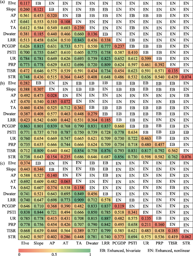
Figure 9 Interaction effect (q) between influencing factors on LUF-LUE mismatch in 2018 (a. PDF-APE mismatch; b. LVF-UCE mismatch; c. ELF-ESE mismatch)

4.5 Dynamic changes of factors’ impact on the mismatch of LUFs and LUEs

The q values and ρ values were calculated to analyze the dynamic changes of factors’ impact on the mismatch of LUFs and LUEs from 2000 to 2018 (Figure 10). For PDF-APE mis-match, eight influencing factors depicted a constant influence direction, while four influencing factors changed from a positive to negative impact and TISR changed from a negative to a positive influence (Figure 10a). The impact of AP, TA, LRR, PCGDP, PSTI, UR, and PRP on PDF-APE mismatch showed a fluctuation increase, which indicated an enhanced role of these influencing factors. It was worth noting that PSTI had the greatest impact on PDF-APE mismatch in 2010, with a q value of 0.491. In contrast, the remaining six influencing factors all showed a downward trend, and multiple influencing factors had no significant impact over 2000-2018.
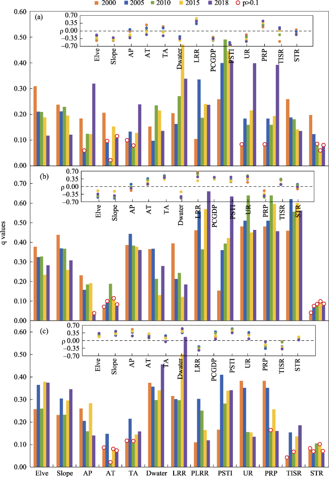
Figure 10 The trend of determinant power (q) and Spearman’s correlation coefficient (ρ) for influencing factors on LUF-LUE mismatch from 2000 to 2018 (a. PDF-APE mismatch; b. LVF-UCE mismatch; c. ELF-ESE mismatch)
PCGDP, PSTI, UR, PRP, and TISR dominated LVF-UCE mismatch, and their q values were above 0.5 over time (Figure 10b), indicating that external influences played a decisive role in LVF-UCE mismatch. It should be noted that STR had no significant impact on LVF-UCE mismatch, and its q value was less than 0.1 during the study period. The impact of Elve, Slope, TA, Dwater, and LRR has continuously declined from 2000 to 2018, implying a diminished role of regional background conditions. In addition, AP and AT had a smaller impact on LVF-UCE mismatch, and their q values were basically less than 0.2 during the study period. Overall, more than 80% of the influencing factors showed a constant influence direction, while AP and STR jumped between positive and negative impacts.
For ELF-ESE mismatch, most of the influencing factors showed a positive impact, and LRR, PRP, and TISR had a negative impact, while TA changed from a positive to a negative impact during the study period (Figure 10c). The impact of Elve, Slope, Dwater, and LRR on ELF-ESE mismatch showed a trend of fluctuating growth, and the greatest impact appeared in LRR in 2018 (q=0.578), indicating that regional background conditions gradually dominated ELF-ESE mismatch. Instead, AP, PCGDP, PSTI, UR, and PRP presented a fluctuating decreasing impact. However, AT, TA, TISR, and STR were the least influential factors with q values basically less than 0.2, and they were not significant over multiple years.

5 Discussion

5.1 Insights into changes for the mismatch of LUFs and LUEs and their influencing factors

The coordinated development of LUFs and LUEs is one of the key contents to alleviate land use conflicts and contradictions. This study revealed the mismatch between LUFs and LUEs through the spatial mismatch analysis, which provided more abundant information for the optimization and management of land resources. The results showed that multiple cities had low production functional efficiency in the MRYR during the study period, especially those around Wuhan. Although the APE of these regions has greatly improved from 2000 to 2018, their PDF values have been at the highest level, resulting in the failure to fully develop the potential of PDF (Figures 3-4). Wuhan and the surrounding areas of Changsha showed higher production functional efficiency. In Wuhan, the increase in financial investment in agricultural scientific and technological development, and the adjustment of planting structure all contributed to high production functional efficiency (Chen et al., 2023). Different from Wuhan, Changsha-Zhuzhou-Xiangtan Metropolis have improved their production functional efficiency mainly through regional coordinated development (Yang et al., 2022; Liu et al., 2023). The core cities, such as Wuhan, Changsha, and Nanchang, exhibited a significant inefficient LVF-UCE mismatch. This is because improved infrastructure and dense population density directly enhanced the LVF in the core cities (Lan et al., 2020; Yue et al., 2021; Xie et al., 2023), while their UCEs tended to increase slowly with socio-economic development (Jin et al., 2018). More than 90% of cities showed spatial matching or high living functional efficiency in the MRYR from 2000-2018. With the implementation of a series of regional coordinated development policies, such as the Development Plan for Urban Agglomerations in the MRYR and the Action Plan for High-quality Coordinated Development of Capital Cities for Urban Agglomerations in the MRYR, the UCE in the MRYR has been further improved (Wang and Li, 2023; Yang et al., 2023). In the region around the three core cities, the area around Wuhan exhibited significantly high ecological functional efficiency, while the areas around Changsha and Nanchang were characterized by an inefficient ELF-ESE mismatch. The reason may be that the ecological damage of the surrounding cities in Wuhan was relatively serious, which led to the deterioration of their ELFs during the study period (Dai et al., 2020; Zhao et al., 2023). The following analysis of the trade-offs and synergies among the mismatch of LUFs and LUEs confirmed that the conflicts between PDF-APE mismatch and ELF-ESE mismatch, and LVF-UCE mismatch and ELF-ESE mismatch were increasing, caused by the continuous decline in the ESE.
A confluence of regional background conditions and external influences dominated the spatial mismatch between LUFs and LUEs in the MRYR (Figure 11). External influences played a more active role than regional background conditions, especially in PDF-APE mismatch and LVF-UCE mismatch, which is consistent with previous studies (Feng et al., 2021; Liu et al., 2021; Zhou and Lu, 2023). LRR and PRP had a strong positive impact on PDF-APE mismatch, and over time, this impact exhibited a fluctuating increase, while other influencing factors showed a significant negative impact, and some of them experienced a transition from positive to negative, such as AP and TA. The previous studies have confirmed that rural depopulation and cultivated land loss were detrimental to the sustainability of agricultural resources (Liu et al., 2023a). The TA and LRR interaction had the largest effect on PDF-APE mismatch, and the interaction of the proportion of cultivated area and transportation accessibility exacerbated PDF-APE mismatch. PCGDP and PSTI have a significant positive effect on the LVF-UCE mismatch, mainly because an increase in the level of investment greatly improves UCE, and the positive effect of the level of investment on UCE continues to increase over time. The interaction effects of PCGDP and TISR with other factors have the most intense impact on the LVF-UCE mismatch, with capital investment and technology innovation greatly increasing UCE. It is worth noting that LRR has a significant negative effect on ELF-ESE mismatch, which is due to the fact that when the production and ecological space are certain, the expansion of the production space inhibits the functioning and utilization of the ecological space to a certain extent. Meanwhile, when the internal factor LRR interacted with other socio-economic external factors, the effect on the ELF-ESE mismatch impact was sharply enhanced.
Figure 11 Mechanisms of influence of LUFs and LUEs

5.2 Policy implications

This study represents an important advance in the analysis of LUFs and LUEs, and their mismatch. For the PDF-APE mismatch, strictly controlling urban sprawl is considered the basis for solving these problems. In areas with functional advantages in agricultural production, it is necessary to develop high-standard basic farmland and improve the level of agricultural modernization in order to give full play to their advantages, so as to promote the matching of the functional background with the efficiency of utilization. At the same time, new development models for the agricultural industry should be encouraged in order to increase production value, such as encouraging the development of new industries through agricultural-ecological complexes, sightseeing tours of working farms, and “hands-on” leisure experiences. For the LVF-UCE mismatch, it is necessary to optimize the structure of industrial development and construct high-quality patterns under the industrial integration and green development model. Changes in efficiency improvement through increased investment in science and technology, which in turn reduces resource dependence and overconsumption in urban construction and reduces pollutant emissions. At the same time, strengthening the planning and management of the living environment will help ensure the fair development of public infrastructure, improving the living standards of urban residents (Jiang and Lu, 2020). Seeking low-pollution and livability patterns in matching between function and efficiency in urban space. For the ELF-ESE mismatch, Strict management of the red line of ecological protection is to ensure the bottom line of the area of ecological protection. Ecological protection and restoration projects should be implemented (Tao et al., 2022) to improve the quality and stability of ecosystems. Optimize the spatial pattern of ecological elements according to the system of national parks and nature reserves, thereby effectively enhancing the value of regional ecosystem services and carbon sinks.

5.3 Limitations and research prospective

The study explored the spatial mismatch of land use functions and efficiency in the three types of space and their influencing factors, but there are still some limitations. First, we explored the mismatch at the city scale in the MRYR, which may ignore the variability of influences at smaller scales (county or below). In addition, we divided the internal and external factors to explore the impacts on the mismatch of land use functions and land use efficiency, however, the complex nonlinear mechanisms affecting the mismatch of the two need to be further investigated. We aim to overcome these limitations in our future research.

6 Conclusion

Using spatial mismatch analysis, trade-off analysis, and the geographical detector, we reveal the mismatch between land use functions and efficiency in MRYR from 2000 to 2018. The key findings of the study are as follows:
The spatial heterogeneity of the agricultural production function, urban construction function, and ecological protection function is clearly characterized. From 2000-2018, the efficiency of agricultural space and urban space utilization increased significantly, and the efficiency of ecological space utilization decreased. From 2000 to 2018, the mismatch in agricultural space has changed more dramatically, and overall, the mismatch has eased. The space of urban areas is relatively well-matched. The degree of ecological spatial mismatch is less variable. The trade-offs and synergies between the three spatial mismatches varied significantly. The interaction of the proportion of cultivated area and transportation accessibility exacerbated the mismatch in agricultural space. The interaction effects of capital investment and technology innovation with other factors have the most intense impact on the mismatch in urban space. The internal factor cultivated area interacts with other external factors to drastically affect ecological spatial mismatch.
[1]
Chai J, Wang Z, Yang J et al., 2019. Analysis for spatial-temporal changes of grain production and farmland resource: Evidence from Hubei province, central China. Journal of Cleaner Production, 207: 474-482.

DOI

[2]
Chen H, Costanza R, Kubiszewski I, 2022. Land use trade-offs in China’s protected areas from the perspective of accounting values of ecosystem services. Journal of Environmental Management, 315: 115178.

DOI

[3]
Chen W, Wang G, Cai W et al., 2023. Spatiotemporal mismatch of global grain production and farmland and its influencing factors. Resources, Conservation and Recycling, 194: 107008.

[4]
Chen Y, Chen Z, Xu G et al., 2016. Built-up land efficiency in urban China: Insights from the General Land Use Plan (2006-2020). Habitat International, 51: 31-38.

DOI

[5]
Cheng J, Sun Q, Guo M et al., 2014. Research on regional disparity and dynamic evolution of eco-efficiency in China. China Population, Resources and Environment, 24(1): 47-54. (in Chinese)

[6]
Cueva J, Yakouchenkova I A, Fröhlich K et al., 2022. Synergies and trade-offs in ecosystem services from urban and peri-urban forests and their implication to sustainable city design and planning. Sustainable Cities and Society, 82: 103903.

DOI

[7]
Cui X, Deng X, Wang Y, 2023. Evolution characteristics and driving factors of rural regional functions in the farming-pastoral ecotone of northern China. Journal of Geographical Sciences, 33(10): 1989-2010.

DOI

[8]
Dai X, Wang L, Huang C et al., 2020. Spatio-temporal variations of ecosystem services in the urban agglomerations in the middle reaches of the Yangtze River, China. Ecological Indicators, 115: 106394.

DOI

[9]
Deng X, Gibson J, 2019. Improving eco-efficiency for the sustainable agricultural production: A case study in Shandong, China. Technological Forecasting and Social Change, 144: 394-400.

DOI

[10]
Fan Y, Gan L, Hong C et al., 2021. Spatial identification and determinants of trade-offs among multiple land use functions in Jiangsu province, China. Science of The Total Environment, 772: 145022.

DOI

[11]
Fan Y, Jin X, Gan L et al., 2022. Dynamics of spatial associations among multiple land use functions and their driving mechanisms: A case study of the Yangtze River Delta region, China. Environmental Impact Assessment Review, 97: 106858.

DOI

[12]
Fan Y, Jin X, Gan L et al., 2023. Exploring an integrated framework for “dynamic-mechanism-clustering” of multiple cultivated land functions in the Yangtze River Delta region. Applied Geography, 159: 103061.

DOI

[13]
Feng R, Wang F, Wang K, 2021. Spatial-temporal patterns and influencing factors of ecological land degradation-restoration in Guangdong-Hong Kong-Macao Greater Bay Area. Science of The Total Environment, 794: 148671.

DOI

[14]
Gao X, Zhang A, Sun Z, 2020. How regional economic integration influence on urban land use efficiency? A case study of Wuhan metropolitan area, China. Land Use Policy, 90: 104329.

DOI

[15]
Gao Y, Wang Z, Xu F, 2023a. Geospatial characteristics and the application of land use functions in the Yangtze River Economic Belt, China: Perspectives on provinces and urban agglomerations. Ecological Indicators, 155: 110969.

DOI

[16]
Gao Y, Wang Z, Zhang L et al., 2023b. Spatial identification and multilevel zoning of land use functions improve sustainable regional management: A case study of the Yangtze River Economic Belt, China. Environmental Science and Pollution Research, 30(10): 27782-27798.

DOI

[17]
Guo B, He D, Jin G, 2023. Agricultural production efficiency estimation and spatiotemporal convergence characteristic analysis in the Yangtze River Economic Belt: A semi-parametric metafrontier approach. Land Degradation & Development, 34(15): 4635-4648.

DOI

[18]
He J, Shi X, Fu Y et al., 2020. Evaluation and simulation of the impact of land use change on ecosystem services trade-offs in ecological restoration areas, China. Land Use Policy, 99: 105020.

DOI

[19]
He T, Lu Y, Yue W et al., 2023. A new approach to peri-urban area land use efficiency identification using multi-source datasets: A case study in 36 Chinese metropolitan areas. Applied Geography, 150: 102826.

DOI

[20]
Hou X, Liu J, Zhang D et al., 2019. Impact of urbanization on the eco-efficiency of cultivated land utilization: A case study on the Yangtze River Economic Belt, China. Journal of Cleaner Production, 238: 117916.

DOI

[21]
Ji Z, Liu C, Xu Y et al., 2023. Quantitative identification and the evolution characteristics of production-living-ecological space in the mountainous area: From the perspective of multifunctional land. Journal of Geographical Sciences, 33(4): 779-800.

DOI

[22]
Jiang X, Lu X, 2020. Temporal and spatial characteristics of coupling and coordination degree between urbanization and human settlement of urban agglomerations in the middle reaches of the Yangtze River. China Land Science, 34(1): 25-33. (in Chinese)

[23]
Jin G, Deng X, Zhao X et al., 2018. Spatiotemporal patterns in urbanization efficiency within the Yangtze River Economic Belt between 2005 and 2014. Journal of Geographical Sciences, 28(8): 1113-1126.

DOI

[24]
Jin G, Guo B, Cheng J et al., 2022. Layout optimization and support system of territorial space: An analysis framework based on resource efficiency. Acta Geographica Sinica, 77(3): 534-546. (in Chinese)

DOI

[25]
Ke X, Zhang Y, Zhou T, 2023. Spatio-temporal characteristics and typical patterns of eco-efficiency of cultivated land use in the Yangtze River Economic Belt, China. Journal of Geographical Sciences, 33(2): 357-372.

DOI

[26]
Kuang B, Lu X, Zhou M et al., 2020. Provincial cultivated land use efficiency in China: Empirical analysis based on the SBM-DEA model with carbon emissions considered. Technological Forecasting and Social Change, 151: 119874.

DOI

[27]
Lan F, Gong X, Da H et al., 2020. How do population inflow and social infrastructure affect urban vitality? Evidence from 35 large- and medium-sized cities in China. Cities, 100: 102454.

DOI

[28]
Li S, An W, Zhang J et al., 2023. Optimizing limit lines in urban-rural transitional areas: Unveiling the spatial dynamics of trade-offs and synergies among land use functions. Habitat International, 140: 102907.

DOI

[29]
Li T, Long H, Zhang Y et al., 2017. Analysis of the spatial mismatch of grain production and farmland resources in China based on the potential crop rotation system. Land Use Policy, 60: 26-36.

DOI

[30]
Li Y, Li Y, Karácsonyi D et al., 2020. Spatio-temporal pattern and driving forces of construction land change in a poverty-stricken county of China and implications for poverty-alleviation-oriented land use policies. Land Use Policy, 91: 104267.

DOI

[31]
Liang J, Li S, Li X et al., 2021. Trade-off analyses and optimization of water-related ecosystem services (WRESs) based on land use change in a typical agricultural watershed, southern China. Journal of Cleaner Production, 279: 123851.

DOI

[32]
Liu C, Xu Y, Huang A et al., 2018a. Spatial identification of land use multifunctionality at grid scale in farming-pastoral area: A case study of Zhangjiakou city, China. Habitat International, 76: 48-61.

DOI

[33]
Liu C, Xu Y, Lu X et al., 2021. Trade-offs and driving forces of land use functions in ecologically fragile areas of northern Hebei province: Spatiotemporal analysis. Land Use Policy, 104: 105387.

DOI

[34]
Liu J, Jin X, Xu W et al., 2020. A new framework of land use efficiency for the coordination among food, economy and ecology in regional development. Science of The Total Environment, 710: 135670.

DOI

[35]
Liu J, Jin X, Xu W et al., 2023a. Assessing trade-offs and synergies among multiple land use functional efficiencies: Integrating ideal reference and key indicators for sustainable landscape management. Applied Geography, 158: 103037.

DOI

[36]
Liu M, Xiong Y, Zhang A, 2023b. Multi-scale telecoupling effects of land use change on ecosystem services in urban agglomerations: A case study in the middle reaches of Yangtze River urban agglomerations. Journal of Cleaner Production, 415: 137878.

DOI

[37]
Liu S, Xiao W, Ye Y et al., 2023. Rural residential land expansion and its impacts on cultivated land in China between 1990 and 2020. Land Use Policy, 132: 106816.

DOI

[38]
Liu Y, Zhang Z, Zhou Y, 2018c. Efficiency of construction land allocation in China: An econometric analysis of panel data. Land Use Policy, 74: 261-272.

DOI

[39]
Long H, Ge D, Zhang Y et al., 2018b. Changing man-land interrelations in China’s farming area under urbanization and its implications for food security. Journal of Environmental Management, 209: 440-451.

DOI

[40]
Lu D, 2018. Conservation of the Yangtza River and sustainable development of the Yangtze River Economic Belt: An understanding of General Secretary Xi Jinping’s important instructions and suggestions for their implementation. Acta Geographica Sinica, 73(10): 1829-1836. (in Chinese)

[41]
Lu X, Kuang B, Li J, 2018. Regional difference decomposition and policy implications of China’s urban land use efficiency under the environmental restriction. Habitat International, 77: 32-39.

DOI

[42]
Lyu Y, Wang M, Zou Y et al., 2022. Mapping trade-offs among urban fringe land use functions to accurately support spatial planning. Science of The Total Environment, 802: 149915.

DOI

[43]
Ma W, Jiang G, Chen Y et al., 2020a. How feasible is regional integration for reconciling land use conflicts across the urban-rural interface? Evidence from Beijing-Tianjin-Hebei metropolitan region in China. Land Use Policy, 92: 104433.

DOI

[44]
Ma X, Zhu J, Zhang H et al., 2020b. Trade-offs and synergies in ecosystem service values of inland lake wetlands in Central Asia under land use/cover change: A case study on Ebinur Lake, China. Global Ecology and Conservation, 24: e01253.

DOI

[45]
Meng J, Wang Q, Li F et al., 2019. Assessing multifunctional land use in the middle reach of the Heihe River basin based on spatial variances. Geographical Research, 38(2): 369-382. (in Chinese)

DOI

[46]
Ng C N, Xie Y J, Yu X J, 2011. Measuring the spatio-temporal variation of habitat isolation due to rapid urbanization: A case study of the Shenzhen river cross-boundary catchment, China. Landscape and Urban Planning, 103(1): 44-54.

DOI

[47]
Peng J, Zhao M, Guo X et al., 2017. Spatial-temporal dynamics and associated driving forces of urban ecological land: A case study in Shenzhen City, China. Habitat International, 60: 81-90.

DOI

[48]
Qu Y, Zhang Y, Wang S et al., 2023. Coordinated development of land multi-function space: An analytical framework for matching the supply of resources and environment with the use of land space for ecological protection, agricultural production and urban construction. Journal of Geographical Sciences, 33(2): 311-339.

DOI

[49]
Ren J, Zhou W, Guo J et al., 2021. Analysis on spatial-temporal characteristics and influencing factors of multi-functionality of land use in Qinghai-Tibet alpine mountain areas: A case study of Haidong city in Qinghai province, China. China Land Science, 35(4): 90-100. (in Chinese)

[50]
Song W, Pijanowski B C, Tayyebi A, 2015. Urban expansion and its consumption of high-quality farmland in Beijing, China. Ecological Indicators, 54: 60-70.

DOI

[51]
Song Y, Yeung G, Zhu D et al., 2022. Efficiency of urban land use in China’s resource-based cities, 2000-2018. Land Use Policy, 115: 106009.

DOI

[52]
Sun H, Liang H, Chang X et al., 2015. Land use patterns on carbon emission and spatial association in China. Economic Geography, 35(3): 154-162. (in Chinese)

[53]
Tao J, Dong P, Lu Y, 2022. Spatial-temporal analysis and influencing factors of ecological resilience in the Yangtze River Delta. Resources and Environment in the Yangtze Basin, 31(9): 1975-1987. (in Chinese)

[54]
Tone K, 2010. Variations on the theme of slacks-based measure of efficiency in DEA. European Journal of Operational Research, 200(3): 901-907.

DOI

[55]
Turner B N, Lambin E F, Reenberg A, 2007. The emergence of land change science for global environmental change and sustainability. Proceedings of the National Academy of Sciences of the United States of America, 104(52): 20666-20671.

DOI PMID

[56]
Wang T, Li H, 2023. Have regional coordinated development policies promoted urban carbon emission efficiency? The evidence from the urban agglomerations in the middle reaches of the Yangtze River. Environmental Science and Pollution Research, 30(14): 39618-39636.

DOI

[57]
Wiggering H, Dalchow C, Glemnitz M et al., 2006. Indicators for multifunctional land use: Linking socio-economic requirements with landscape potentials. Ecological Indicators, 6(1): 238-249.

DOI

[58]
Xiang J, Han P, Chen W, 2023. Coordinated development efficiency between cultivated land spatial morphology and agricultural economy in underdeveloped areas in China: Evidence from western Hubei province. Journal of Geographical Sciences, 33(4): 801-822.

DOI

[59]
Xie G, Zhang C, Zhang C et al., 2015a. The value of ecosystem services in China. Resources Science, 37(9): 1740-1746. (in Chinese)

[60]
Xie G, Zhang C, Zhang L et al., 2015b. Improvement of the evaluation method for ecosystem service value based on per unit area. Journal of Natural Resources, 30(8): 1243-1254. (in Chinese)

[61]
Xie H, Chen Q, Lu F et al., 2018. Spatial-temporal disparities, saving potential and influential factors of industrial land use efficiency: A case study in urban agglomeration in the middle reaches of the Yangtze River. Land Use Policy, 75: 518-529.

DOI

[62]
Xie H, Wang X, Wang Z et al., 2023. Mismatch between infrastructure supply and demand within a 15-minute living circle evaluation in Fuzhou, China. Heliyon, 9(9): e20130.

DOI

[63]
Xie X, Fang B, Xu H et al., 2021. Study on the coordinated relationship between urban land use efficiency and ecosystem health in China. Land Use Policy, 102: 105235.

DOI

[64]
Xu M, Zhang Z, 2021. Spatial differentiation characteristics and driving mechanism of rural-industrial Land transition: A case study of Beijing-Tianjin-Hebei region, China. Land Use Policy, 102: 105239.

DOI

[65]
Xue D, Yue L, Ahmad F et al., 2022. Empirical investigation of urban land use efficiency and influencing factors of the Yellow River basin Chinese cities. Land Use Policy, 117: 106117.

DOI

[66]
Yang B, Wang Z, Zou L et al., 2021a. Exploring the eco-efficiency of cultivated land utilization and its influencing factors in China’s Yangtze River Economic Belt, 2001-2018. Journal of Environmental Management, 294: 112939.

DOI

[67]
Yang B, Yang J, Tan L et al., 2023. Understanding the change of land space utilization efficiency with different functions and its coupling coordination: A case study of urban agglomeration in the middle reaches of the Yangtze River, China. Journal of Geographical Sciences, 33(2): 289-310.

DOI

[68]
Yang B, Zhang Z, Wu H, 2022. Detection and attribution of changes in agricultural eco-efficiency within rapid urbanized areas: A case study in the urban agglomeration in the middle reaches of Yangtze River, China. Ecological Indicators, 144: 109533.

DOI

[69]
Yang S, Bai Y, Alatalo J M et al., 2021b. Spatio-temporal changes in water-related ecosystem services provision and trade-offs with food production. Journal of Cleaner Production, 286: 125316.

DOI

[70]
Yin R, Wang Z, Chai J et al., 2022. The evolution and response of space utilization efficiency and carbon emissions: A comparative analysis of spaces and regions. Land, 11(3): 438.

DOI

[71]
Yin R, Wang Z, Xu F, 2023. Multi-scenario simulation of China’s dynamic relationship between water-land resources allocation and cultivated land use based on shared socioeconomic pathways. Journal of Environmental Management, 341: 118062.

DOI

[72]
Yu J, Zhou K, Yang S, 2019. Land use efficiency and influencing factors of urban agglomerations in China. Land Use Policy, 88: 104143.

DOI

[73]
Yue W, Chen Y, Thy P T M et al., 2021. Identifying urban vitality in metropolitan areas of developing countries from a comparative perspective: Ho Chi Minh City versus Shanghai. Sustainable Cities and Society, 65: 102609.

DOI

[74]
Zhang H, Wang Z, 2022. Human activities and natural geographical environment and their interactive effects on sudden geologic hazard: A perspective of macro-scale and spatial statistical analysis. Applied Geography, 143: 102711.

DOI

[75]
Zhang H, Wang Z, Liu J et al., 2022a. Selection of targeted poverty alleviation policies from the perspective of land resources-environmental carrying capacity. Journal of Rural Studies, 93: 318-325.

DOI

[76]
Zhang J, Li S, Lin N et al., 2022b. Spatial identification and trade-off analysis of land use functions improve spatial zoning management in rapid urbanized areas, China. Land Use Policy, 116: 106058.

DOI

[77]
Zhang L, Dawes W R, Walker G R, 2001. Response of mean annual evapotranspiration to vegetation changes at catchment scale. Water Resources Research, 37(3): 701-708.

DOI

[78]
Zhang L, Hickel K, Dawes W R et al., 2004. A rational function approach for estimating mean annual evapotranspiration. Water Resources Research, 40(2): 12-19.

[79]
Zhang X, Gu R, 2022. Spatio-temporal pattern and multi-scenario simulation of land use conflict: A case study of the Yangtze River Delta urban agglomeration. Geographical Research, 41(5): 1311-1326. (in Chinese)

DOI

[80]
Zhang Z, Liu Y, Wang Y et al., 2020. What factors affect the synergy and tradeoff between ecosystem services, and how, from a geospatial perspective? Journal of Cleaner Production, 257: 120454.

DOI

[81]
Zhang Z, Zhao W, Gu X, 2014. Changes resulting from a land consolidation project (LCP) and its resource-environment effects: A case study in Tianmen city of Hubei province, China. Land Use Policy, 40: 74-82.

DOI

[82]
Zhao H, He J, Liu D et al., 2023. Incorporating ecological connectivity into ecological functional zoning: A case study in the middle reaches of Yangtze River urban agglomeration. Ecological Informatics, 75: 102098.

DOI

[83]
Zhou Y, Lu Y, 2023. Spatiotemporal evolution and determinants of urban land use efficiency under green development orientation: Insights from 284 cities and eight economic zones in China, 2005-2019. Applied Geography, 161: 103117.

DOI

[84]
Zhu C, Dong B, Li S et al., 2021. Identifying the trade-offs and synergies among land use functions and their influencing factors from a geospatial perspective: A case study in Hangzhou, China. Journal of Cleaner Production, 314: 128026.

DOI

Outlines

/