Research Articles

Geographical features and development models of estuarine cities

  • CHEN Mingxing , 1, 2 ,
  • XIAN Yue 1, 2 ,
  • HUANG Yaohuan 2, 3 ,
  • SUN Zhigang 2, 4, 5, 6 ,
  • WU Chengbin 2, 3
Expand
  • 1. Key Laboratory of Regional Sustainable Development Modeling, Institute of Geographic Sciences and Natural Resources Research, CAS, Beijing 100101, China
  • 2. College of Resource and Environment, University of Chinese Academy of Sciences, Beijing 100049, China
  • 3. State Key Laboratory of Resources and Environmental Information System, Institute of Geographic Sciences and Natural Resources Research, CAS, Beijing 100101, China
  • 4. Key Laboratory of Ecosystem Network Observation and Modeling, Institute of Geographic Sciences and Natural Resources Research, CAS, Beijing 100101, China
  • 5. Zhongke Shandong Dongying Institute of Geography, Dongying 257509, Shandong, China
  • 6. CAS Engineering Laboratory for Yellow River Delta Modern Agriculture, Institute of Geographic Sciences and Natural Resources Research, CAS, Beijing 100101, China

Chen Mingxing (1982-), PhD and Professor, specialized in urbanization and regional sustainable development. E-mail:

Received date: 2023-03-14

  Accepted date: 2023-07-24

  Online published: 2024-01-08

Supported by

The Strategic Priority Research Program of the Chinese Academy of Sciences(XDA23100301)

The Chinese Academy of Sciences Basic Frontier Science Research Program from 0 to 1 Original Innovation Project(ZDBS-LYD-QC005)

National Natural Science Foundation of China(42171204)

Abstract

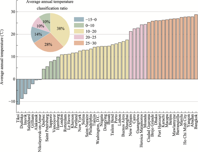
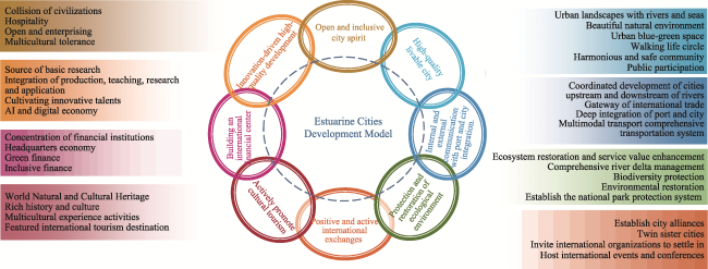
Cities are the key areas for human beings to achieve sustainable development goals in the future. Estuarine cities are a special type of coastal city in urgent need of a clear definition. This paper proposed that estuarine cities are cities developed on the coast where rivers and oceans meet and defined four connotations, including the intersection of rivers and marine water systems, the coordinated development of land and oceans, the location advantages of connecting rivers and seas, and the important fragility of the ecological environment. We used HydroSHEDS, OSM, GPW, and urban socioeconomic statistics and selected 50 estuarine cities with large rivers as representatives to summarize the main geographical basis and socioeconomic characteristics. Cities are primarily found in low-altitude, flat regions with average annual temperatures that mainly vary from 10°C to 25°C, relatively abundant precipitation, and extensive biological resources. There are substantial variations in the socioeconomic features of estuarine cities. We proposed eight development patterns, including open and inclusive city spirit, high-quality livable cities, high-quality development driven by innovation, integration of internal and external communication with ports and cities, construction of an international financial center, ecological environment protection and restoration, active promotion of cultural tourism, and positive international exchanges.

Cite this article

CHEN Mingxing , XIAN Yue , HUANG Yaohuan , SUN Zhigang , WU Chengbin . Geographical features and development models of estuarine cities[J]. Journal of Geographical Sciences, 2024 , 34(1) : 25 -40 . DOI: 10.1007/s11442-024-2193-3

1 Introduction

Cities have become the residence of more than half of the world’s population, and it is urgent to explore sustainable development models for cities to adapt to global changes (Chen et al., 2021). Cities will play a crucial role in how to cope with the increasingly severe challenges of sustainable development, what kind of development concept and path to choose, and whether human beings can achieve the goal of sustainable development in the future (Chen et al., 2022b; Graça et al., 2022). The coastal zone has become an area with continuous population concentration, the fastest growth, and multiple risks because human beings have been attracted by the sea for a long time (McGranahan et al., 2007; Sanford et al., 2011; Barragán et al., 2015; de Andrés et al., 2018; Lu, 2020). Over 600 million people live in coastal areas below 10 m above sea level, accounting for 10% of the world’s population (UN, 2017). As a special type of coastal city, the estuarine city has unique, complex, and typical characteristics. Near estuaries are about 70% of the world’s largest cities (Leuven et al., 2019). The estuary forms a transition zone between the river environment and the marine environment and has obvious characteristics of a terrestrial-marine ecotone. The estuary area is not only affected by the ocean, such as tides, waves, and salt water inflow, but also by rivers, such as fresh water and sediments, so it is often rich in biological resources, mineral resources, and water resources (Hoque et al., 2015). At the same time, the estuarine city has excellent water transport conditions, which can provide important nodes and channels for transportation, thereby promoting the development of human social and economic activities such as industry, agriculture, and transportation (Barbosa et al., 2016). At present, the estuary area is facing challenges such as sediment deposition (Hui et al., 2009; Zhu et al., 2020), floods (Vousdoukas et al., 2020; Harrison et al., 2022), eutrophication (Howarth et al., 2000; Huang et al., 2003), and biological degradation (Borja et al., 2010). Meanwhile, with the rapid development of globalization, information technology, and transportation, the world is shifting from “location space” to “flow space”, making the advantages and central node functions of estuarine cities more prominent (Jiang et al., 2022). The sustainable development of estuary cities is urgently needed for both human society and the natural environment (Wu et al., 2023).
However, estuarine cities have not received enough attention in coastal research, and there is neither a clear conceptual connotation nor an explanation of the characteristic model of development in academia. Academic research on estuaries mainly focuses on the ecological environment, such as soil deposits (Dai et al., 2018; He et al., 2019), water quality (Kerner, 2007; Adams et al., 2019), and biodiversity (Fisher et al., 2015), of estuary deltas exposed to disasters caused by rivers and storm surges (Harrison et al., 2022), instead of studying the sustainable development model of the cities in the estuary area. Some studies mentioned “estuarine cities” and talked about governance and disaster prevention (Liu et al., 2000; Chen et al., 2019a), but did not construct the concept of estuarine cities or analyze the development and protection faced by estuarine cities from the perspective of urban development.
To address complex and severe sustainable development challenges, the concept of urban development has evolved and has proposed ideas such as people-oriented (Chen et al., 2019b; Chen et al., 2020), sustainable development (Rogers et al., 2012; Chen et al., 2022a), inclusive sharing (Bannister et al., 2013), resilient development (Coaffee et al., 2018), and more. New urban development concepts have also emerged, including livable cities (Ye et al., 2022), resilient cities (Coaffee et al., 2018; Zhao et al., 2020), ecological cities (Jiang et al., 2015), sponge cities (Yu et al., 2015), low-carbon cities (Chen et al., 2022c), smart cities (Zhen et al., 2015), and city cooperation (Kurowska-Pysz et al., 2018). The United Nations, in the 2022 World City Report, proposed “The Diversity and Vision for the Future of Cities”. The choice of urban development path should correspond to the diverse urban environment and development characteristics and take differentiated measures and responses for different types of cities (UN-Habitat, 2022). This means that further refinement and definition of the type of city are important to explore the differentiated sustainable development patterns of cities and their practices. In addition, coastal city is still a broad concept due to the large scope of coastal areas, the large number of cities, and the huge differences between cities. Extracting and analyzing characteristic and representative cities is a natural extension of the refinement of city governance and sustainable urbanization research.
This research proposes the concept and connotation of estuarine cities, that is, cities developed on the coast where rivers and oceans meet. The connotative characteristics of the estuarine city are mainly reflected in four aspects: the intersection of rivers and marine water systems; the coordinated development of land and oceans; the location advantages of connecting rivers and seas; and the important fragility of the ecological environment. By taking the cities in the estuary areas of large rivers as an example and analyzing the natural geographical basis and economic and social features of their development. Finally, we proposed characteristic development patterns for estuarine cities.

2 Concept and connotation of estuarine city

2.1 Concept of estuarine city

In current research, there is rich content related to coastal cities, such as port cities, seaside cities, coastal cities, etc. However, there is no clear definition for cities at the mouth of rivers. Port cities are located along rivers, lakes, oceans, etc., have ports, and are the hub of water and land transportation. The most important driving force for their growth comes from the port, including the initial contact between the port and city, mutual relationships, the agglomeration effect, and the urban self-growth effect (Guo et al., 2013). Port cities are not only the center of economic activities but also an important hub of the transportation network, becoming a gathering point for import and export trade, industry, and tourism (Wang et al., 2015; Zheng et al., 2020). However, port cities rely on ports as their driving force and can be divided into estuary port cities, coastal port cities, river port cities, and lake port cities, depending on their geographical location. Estuary port cities and coastal port cities have a certain degree of overlap with estuarine cities, but not completely, mainly because the construction of port cities is mainly influenced by the conditions for building ports in bays (coasts) and is not necessarily located in the area of the mouth of rivers. Seaside cities are cities built along the coast, known for their beautiful environment, suitable climate, and excellent conditions for developing marine tourism (Han et al., 2022). Seaside tourism originated in England in the mid-18th century and entered the leisure and holiday development stage in the mid-20th century. China has 18,000 km of mainland coastline and abundant excellent bays and port cities in coastal areas, providing a unique advantage for developing seaside tourism. Cities at the mouth of rivers are similar to seaside cities in terms of natural conditions for developing bays or seaside tourism. In addition, cities at the mouth of rivers also have the scenic beauty of rivers, making them important for the development of water-based tourism. In addition, estuarine cities also have river landscapes, while coastal cities are not necessarily located along rivers. Coastal cities are located in belt-shaped areas extending from land to sea, including coastal plains, estuary deltas, and underwater slopes. They are in a unique environmental system where coastal dynamics interact with coastal land and have location advantages such as convenient transportation and rich resources. A coast is a broad area in which cities are not necessarily near the sea or along a river. Estuarine cities are a special type of coastal and riverside cities.
In conclusion, the estuarine cities, port cities, coastal cities, and coastal strip cities have both similarities and differences (as shown in Table 1). Estuarine cities are a new concept in the study of urbanization, urban development, and sustainability. Estuarine cities are characterized by the convergence of a river and ocean, the integration of land and ocean, as well as the close relationship between marine diverse ecosystems and human social and economic activities in the estuary area.
Table 1 A comparison of estuarine cities and related urban concepts
Types of cities Coastal Along river Have ports
Estuarine cities
Port cities
Seaside cities
Coastal cities

Note: “√” indicates that it must have this feature, and “○” means it may have this feature.

2.2 Connotation of an estuarine city

An estuarine city is a specific type or form of city that takes into account both the natural attributes of an estuary and the social and economic attributes of a city. As a node in the multi-phase interface process where rivers and land meet the ocean, an estuarine city has accumulative effects of material and hydrodynamic forces and interwoven impacts of water and land ecosystems, often in areas where the local ecological environment is particularly fragile and complex. As a confluence of river basins and near-shore areas, the development of the city’s economy and society must also consider the protection and security of the regional river, ocean water systems, and the local ecological environment. Therefore, the development positioning, city image creation, industry selection, and cultural connotation enhancement of the city are of great significance in promoting the sustainable development of the city and the region. An estuarine city is an important carrier for implementing new development concepts such as ecological civilization construction, sustainable development, and people-oriented livable cities. Its connotations are mainly reflected in the following four aspects: confluence of river and ocean water systems. Estuarine cities are located in transitional areas where river and ocean water systems are frequently impacted, with the characteristics of rivers dominant in the sections of the river near the estuary and ocean characteristics dominant in the coastal areas outside the port. The rivers and ocean interact alternately with each other, with unique properties such as unique sediment movements and interactions between freshwater and saltwater.
Integrated development of land and sea. The estuarine city is located in a transition zone where the land and ocean systems frequently interact and has a unique environment that combines different attributes of land and sea. It is a zone where the Earth’s hydrosphere, lithosphere, atmosphere, and biosphere interact most frequently and actively and requires a systematic approach to the development and protection of both land and sea.
The estuarine city has the unique geographical advantage of being a comprehensive hub that connects upstream, midstream, and downstream cities along the river and also serves as an important hub for establishing international connections with cities in other parts of the world through the ocean. This location creates a distinct advantage that cannot be compared to other cities. The ecological environment is important and fragile. Due to the complex processes and mechanisms of interaction between land and sea in the coastal city region, complex ecological systems such as mixing of fresh and salt water, tidal flat wetlands, river estuary islands, sandbanks, and wetlands are formed. These areas are important convergence and dispersion zones for energy and material flow, are greatly disturbed by human activities, and are highly sensitive to the impact of climate change.

3 Method and data

3.1 Data

The global river vector data was obtained from the HydroSHEDS database, the Esri World Major Rivers layer, and the World River Data Set provided by the “World-wide Hydrogeological Mapping and Assessment Programme” (BGR-UNESCO). City location data was obtained from the high-precision Global Administrative Areas Database (GADM) and administrative boundary data from Open Street Map. River statistical data, including river length, river flow, sea into which river flows, etc., came from various international organizations or government statistical yearbooks, the National Geographic Education Resources Network in the US, etc. City average temperature and precipitation data came from the ERA5-Land meteorological data product, and city vegetation productivity data was calculated based on the MOD17A3HGF product’s annual net primary productivity. Population and economic data came from city or regional statistics, and road network data came from the GRIP Global Road Data Database (https://www.globio.info/download-grip-dataset).

3.2 Method

This study focuses on representative cities at the mouth of a great river in the world and analyzes and summarizes their geographical characteristics and development patterns. First, great rivers that flow into the ocean are defined based on both their natural attributes and their socioeconomic significance. Then, great river estuarine cities are selected based on their location and distribution (Figure 1).
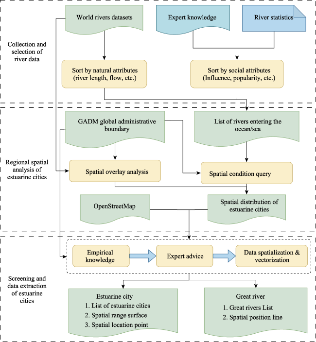
Figure 1 Technical methods for selecting estuarine cities of large rivers
From a natural attribute perspective, big rivers refer to rivers that have significant main natural geographical attributes such as length, flow rate, watershed area, etc., and natural geographical attributes such as average annual sediment discharge, delta area, and number of countries through which the river flows, such as the Mississippi River, Yangtze River, etc., that have developed into famous estuary cities such as New Orleans and Shanghai. From a social and economic perspective, big rivers should include rivers that have played a significant role in human social and economic activities and development processes, although some rivers may not be prominent in natural attributes such as length and flow rate but have played a major role in the region, country, and even in the history of human civilization worldwide, such as the Thames River (346 km) and Rhine River (1233 km), which have given birth to famous estuary cities such as London and Rotterdam and have been defined as estuary cities of big rivers.
Based on the extraction of rivers with estuaries based on basic geographical data, rivers are ranked according to natural attributes such as river length, flow rate, etc. At the same time, based on river social attributes, major rivers with significant regional social, economic, and cultural development and historical significance are selected from each continent, forming a list of big rivers and their estuarine city spatial point data. Secondly, using spatial overlay analysis, the list of 50 big rivers and cities at estuaries is determined (the detailed list is in Appendix 1).

4 Geographical features of the great river estuarine cities

4.1 Geographic distribution

These 50 rivers are distributed across six continents, and they converge extensively with oceanic water systems (Figure 2). The rivers in Asia mainly flow into the Pacific Ocean, followed by the Indian Ocean and the Arctic Ocean. The rivers in North America primarily flow into the Atlantic Ocean, as well as the Pacific Ocean and the Arctic Ocean. In Europe, besides flowing into the Atlantic Ocean, some rivers also flow into the Black Sea and the Mediterranean Sea. African rivers mainly flow into the Atlantic Ocean and the Mediterranean Sea. The rivers in South America all flow into the Atlantic Ocean, and the rivers in Oceania all flow into the Indian Ocean. Nearly one-third of the rivers entering the sea have an average annual runoff of more than 10,000 m3/s, of which the Amazon River in South America has the largest runoff at 210,000 m3/s. The average runoff of the Congo River in Africa, the Orinoco River in South America, and the Yangtze River in Asia exceeds 30,000 m3/s.
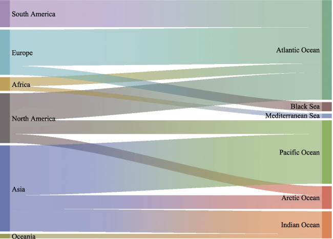
Figure 2 The relationship between the geographic location (continent) of great rivers and the ocean into which the rivers flow
According to the data, the 50 cities where large rivers empty into the ocean are distributed across the six continents (Figure 3), with the highest number of cities being in Asia (19 cities) located along the Pacific coast. In North America and Europe, there are six and eight cities, respectively, located along the Atlantic coast. In South America, there are five cities located along the northern coastal region near the equator. There are three cities in Africa and one in Oceania, respectively.
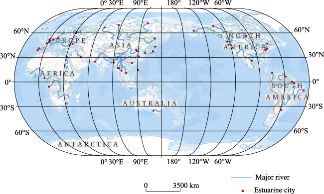
Figure 3 Geographical distribution of cities at the estuary of great rivers

4.2 Natural geographical characteristics

The elevation of the 50 estuarine cities ranges from 0 to 400 m, with an average elevation of 30.59 m, belonging to low-altitude areas. Among them, 12 estuarine cities have an elevation lower than 10 m, mainly located in Southeast Asia and South America. There are more estuarine cities with elevations between 10 m and 50 m—21 in total, accounting for 42%—concentrated in Asia, North America, and Europe. The terrain of the estuarine cities is mainly river delta plains, with flat terrain and low elevations.
The climate in the 50 estuarine cities is generally favorable, with an average temperature range of 10-25°C. According to ERA5-Land weather data analyzed from 1981 to 2020 (Figure 4), 24 of the 50 estuarine cities have an average temperature of 10-25°C, accounting for 48%. A total of 14 cities have an average temperature of 25-30°C, mainly including cities in Asia such as Bangkok, Yangon, and Ho Chi Minh City, accounting for 28%. Five cities have an average temperature of 0-10°C, mainly Quebec, Saint Petersburg, Sapporo, and Vancouver, accounting for 10%. Seven cities have an average temperature below 0°C, mainly including cities in Russia such as Tiksi and Dudinka and in Canada such as Inuvik, accounting for 14%.
Figure 4 The average annual temperature of cities at the estuary of large rivers
Most of the estuarine cities have abundant rainfall. Among the 50 estuarine cities, 28 have an average rainfall of more than 800mm during 1981-2020, located in the humid region and accounting for 56%. During the same period, 16 estuarine cities were located in the semi-humid region with a rainfall between 400-800 mm, accounting for 32% of the total. The other six estuarine cities are located in semi-arid and arid regions, accounting for 12%.
The advantage of biological resource endowment is obvious. In 2020, the mean of net primary productivity (NPP) in 50 coastal cities was 3958 kgC•m-2 a-1, and cities with higher NPP values (Figure 5) were mainly concentrated in South America, mainly Giudad Guayana, Brejo Grande, Belém, and Macapa cities with NPP values exceeding 9000 kgC•m-2 a-1. Among these 50 cities, 32 cities had high NPP levels, with 10 cities distributed in Asia, eight in Europe, eight in North America, and six in South America.
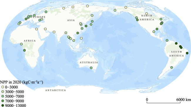
Figure 5 Annual net primary productivity of estuarine cities in 2020

4.3 Socioeconomic characteristics

In terms of social and economic characteristics, there are significant differences in the development of cities around the world, with huge variations in the population size and economic level of different cities. There are six cities with populations exceeding 10 million, including Shanghai, Dhaka, Guangzhou, Karachi, Tianjin, Bangkok, and Cairo. There are five cities with populations between 5 million and 10 million, including London, Ho Chi Minh City, New York, Yangon, and Saint Petersburg. There are 13 cities with populations between 1 million and 5 million, including Busan, Buenos Aires, Vancouver, Belém, Niigata, Dongying, Sapporo, Manila, Hamburg, etc. Some cities along the coast of the Arctic Ocean, such as Gillham, Tiksi, Salekhard, and Inuvik, have populations of less than 100,000. In terms of the total city economy, cities such as New York, London, Shanghai, Philadelphia, Cairo, and Guangzhou, which are more developed, have GDPs exceeding 300 billion US dollars, which are 10 to hundreds of times higher than those of cities in less developed regions. In terms of per capita GDP, cities in North America and Europe, such as Washington, D.C., New York, Portland, and Hamburg, have per capita GDPs exceeding 50,000 US dollars, while cities in Africa, such as Cairo, and in Asia, such as Ho Chi Minh City, Manila, and Dhaka, have lower per capita GDPs, all less than 10,000 US dollars.
The urban infrastructure construction at the estuary is relatively good. In 2015, the average transportation network density of 50 estuarine cities was 3997 m/km2. The transportation density of seven cities is in the range of 10,000-20,000 m/km2, including Buenos Aires, New York, Philadelphia, Manila, Washington, D.C., Lisbon, and Portland. The densities of nine cities range from 5000 m/km2 to 10,000 m/km2, including Cairo, Porto, London, Bangkok, Yangon, and Shanghai. Ten cities had a network density in the range of 1000-5000 m/km2, with an average density of 2491 m/km2, mainly in some cities in Europe and Asia, such as Hamburg, Saint Petersburg, and Rotterdam in Europe and Busan, Sapporo, Guangzhou, Dhaka, and Tianjin in Asia. Seven cities had a network density less than 100 m/km2. According to the statistics of the World Shipping Council, among the 50 seaport cities, five cities rank among the top ten in terms of port throughput in the world, namely Shanghai, Guangzhou, Busan, Tianjin, and Rotterdam. The port throughput of these cities exceeded 14 million TEU in 2020.

5 The characteristic development model of estuarine cities

Facing the increasingly severe global changes and challenges of sustainable development, estuarine cities need to adopt diverse development paths and response strategies. In addition, estuarine cities have similarities and differences in the stage of urban development and can promote common prosperity and sustainable development through learning from each other and cooperation. Based on the development experience of 50 estuarine cities along major rivers, eight characteristic development patterns have been summarized for estuarine city development (Figure 6).
Figure 6 The characteristic models of the development of the world’s estuarine cities
Open and inclusive city spirit. The convergence and collision of different civilizations have resulted in the formation of an open and progressive spirit and a hospitable personality among city residents, enabling them to embrace diversity, attract talents from various cultural backgrounds, and build the city together.
High-quality, livable city. A people-oriented approach is used to create a high-quality, livable city, including a pleasant natural environment and a favorable human environment, such as a city landscape with the characteristics of river and sea systems, blue and green spaces, pedestrian living circles, and harmonious and safe communities, with public participation encouraged.
Innovation-driven, high-quality development. Independent original innovation capability is the core of maintaining a long-term competitive and developmental leading position in the city, and building an original innovation source requires support from basic research. Integrating industry, academia, and research, developing a high-end modern industrial system such as artificial intelligence and the digital economy, and cultivating and attracting innovative talents.
Internal and external communication with port and city integration. Establish close relationships with upstream, midstream, and downstream cities along the river to lead the overall development of the river basin and play a hub role as a gateway city for economic and trade cooperation both domestically and internationally. Develop a comprehensive transportation system to promote deep integration between the port city and the surrounding cities.
Building an international financial center. Utilizing advantages such as ports, shipping, and internationalization, promoting the concentration and aggregation of financial institutions and management platforms, developing headquarters economies, promoting green finance and inclusive finance, and establishing a sustainable urban investment and financing mechanism.
Protection and restoration of the ecological environment. Prioritize comprehensive management of the river delta, protection of biodiversity, and environmental restoration. Establish and improve a national park protection system, promote the restoration and realization of the ecosystem’s service functions, and enhance the quality and stability of the city’s ecosystem.
Active promotion of cultural tourism. Reasonably developing the tourist value of world natural and cultural heritage sites, excavating the city’s historical and cultural heritage, carrying out diverse cultural experience activities, and creating a distinctive international tourist destination.
Promote active international exchanges. Enhance the international influence of the port city by establishing city alliances, friendly city partnerships, inviting international organizations to settle, hosting international events and conferences, and other means.

6 Discussion

Estuarine cities have complex processes and mechanisms of sea-land-air interaction and are essential centers where different circles of the earth’s surface meet for energy exchange and material gathering and dispersal. Owing to their strategic location and proximity to oceans and inland waterways, estuarine cities tend to support strong socioeconomic activity. Human activities have had a strong impact on the ecological environment in the estuary area (Zhang et al., 2015). These cities are highly sensitive to climate change. In the field of ecology and environment, there is a lot of research on governance and disaster prevention in the estuary area. However, the discussion on how to develop estuarine cities is still in its early stage. Estuarine cities have similarities with port cities, seaside cities, and coastal cities but also have obvious differences. In related research on coastal cities and other related studies, the characteristics of river-ocean confluence and land-ocean integration in estuarine cities may not be fully explored. This confirms the importance and urgency of defining the concept and connotation of the estuarine city. This article is mainly for the definition and construction of the concept and connotation of estuary city. Since our focus is on conception, we only made a preliminary analysis and summary of its basic characteristics and development model. There is a need to further study the challenges they face, such as the impact of climate change and adaptation, river-sea interaction hydrodynamics, biodiversity, ecological protection and restoration of estuarine deltas, resilient city construction, etc. Also, exploring new development models such as livable city construction, cultural integration, coastal and city integration, industry upgrading, innovation, and globalization will be important. The study of estuarine city development reflects a cross-disciplinary perspective of human society and nature and requires interdisciplinary research from multiple disciplines to provide a more detailed and important type of city, as well as examples and experiences for diverse and sustainable city development.

7 Conclusion

The article introduces the concept of estuary cities using the example of the 50 great river estuarine cities in the world. The article analyzes the geographical features and development patterns of these cities and reveals their special features as regional and global cities. The concept of estuary cities is mainly characterized by the convergence of river and ocean systems, the integrated development of land and ocean, the location advantage of connecting rivers to the ocean, and an important but fragile ecological environment. Through the study of 50 great river estuarine cities, the research found that these cities are located in low-altitude flat areas with favorable temperatures, mostly between 10-25°C, abundant rainfall, and good biological resources. The social and economic development of estuary cities shows significant differences, with large population and economic disparities among cities. Most cities have well-developed transportation systems. Estuary cities have diverse development patterns, including openness and inclusiveness, high-quality livability, innovation-driven development, integration of port and city, development of financial centers, ecological protection, cultural tourism, and international communication.

Appendix 1 List of great rivers and their estuarine cities

ID Continent River Estuarine city Into the ocean/sea
1 North America Mississippi River New Orleans Atlantic Ocean
2 North America Mackenzie River Inuvik Arctic Ocean
3 North America Yukon River Alakanuk Pacific Ocean
4 North America Saint Lawrence River Quebec Atlantic Ocean
5 North America Rio Grand River Heroica Matamoros Atlantic Ocean
6 North America Nelson River Gillham Arctic Ocean
7 North America Columbia River Portland Pacific Ocean
8 North America Hudson River New York Atlantic Ocean
9 North America Delaware River Philadelphia Atlantic Ocean
10 North America Potomac River Washington, D.C. Atlantic Ocean
11 North America Fraser River Vancouver Pacific Ocean
12 Oceania Murray River Tailem Bend Indian Ocean
13 South America Amazon River Macapa Atlantic Ocean
14 South America Parana River Buenos Aires Atlantic Ocean
15 South America Tocantins River Belém Atlantic Ocean
16 South America Sao Francisco River Brejo Grande Atlantic Ocean
17 South America Orinoco River Ciudad Guayana Atlantic Ocean
18 South America Magdalena River Barranquilla Atlantic Ocean
19 Africa Nile River Cairo Mediterranean Sea
20 Africa Congo River Moanda Atlantic Ocean
21 Africa Niger River Port Harcourt Atlantic Ocean
22 Asia Yangtze River Shanghai Pacific Ocean
23 Asia Yenisei River Dudinka Arctic Ocean
24 Asia Huanghe River Dongying Pacific Ocean
25 Asia Ob-Irtysh River Salekhard Arctic Ocean
26 Asia Amur River Nikolayevsk-on-Amur Pacific Ocean
27 Asia Lena River Tiksi Arctic Ocean
28 Asia Lancang River Ho Chi Minh City Pacific Ocean
29 Asia Jamuna-Brahmaputra River Dhaka Indian Ocean
30 Asia Indus River Karachi Indian Ocean
31 Asia Euphrates River Abadan Indian Ocean
32 Asia Salween River Mawlamyine Indian Ocean
33 Asia Irrawaddy River Yangon Indian Ocean
34 Asia Pearl (Zhujiang) River Guangzhou Pacific Ocean
35 Asia Haihe River Tianjin Pacific Ocean
36 Asia Chao Phraya River Bangkok Pacific Ocean
37 Asia Shinano River Niigata Pacific Ocean
38 Asia Ishikari River Sapporo Pacific Ocean
39 Asia Nakdong River Busan Pacific Ocean
40 Asia Pasig River Manila Pacific Ocean
41 Europe Danube River Sulina Black Sea
42 Europe Dnieper River Kherson Black Sea
43 Europe Rhine River Rotterdam Atlantic Ocean
44 Europe Douro River Porto Atlantic Ocean
45 Europe Seine River Le Havre Atlantic Ocean
46 Europe Elbe River Hamburg Atlantic Ocean
47 Europe Thames River London Atlantic Ocean
48 Europe Tagus River Lisbon Atlantic Ocean
49 Europe Loire River Saint-Nazaire Atlantic Ocean
50 Europe Neva River Saint Petersburg Atlantic Ocean

[1]
Adams J, Pretorius L, Snow G, 2019. Deterioration in the water quality of an urbanised estuary with recommendations for improvement. Water SA, 45(1): 86-96.

DOI

[2]
Bannister J, Kearns A, 2013. The function and foundations of urban tolerance: Encountering and engaging with difference in the city. Urban Studies, 50(13): 2700-2717.

DOI

[3]
Barbosa C C D, Atkinson P M, Dearing J A, 2016. Extravagance in the commons: Resource exploitation and the frontiers of ecosystem service depletion in the Amazon estuary. Science of the Total Environment, 550: 6-16.

DOI

[4]
Barragán J M, de Andrés M, 2015. Analysis and trends of the world’s coastal cities and agglomerations. Ocean & Coastal Management, 114: 11-20.

[5]
Borja A, Dauer D M, Elliott M et al., 2010. Medium- and long-term recovery of estuarine and coastal ecosystems: Patterns, rates, and restoration effectiveness. Estuaries and Coasts, 33(6): 1249-1260.

DOI

[6]
Chen B, Liu G, Wang L et al., 2019a. Determination of water level design for an estuarine city. Journal of Oceanology and Limnology, 37(4): 1186-1196.

DOI

[7]
Chen L, Chen M, Zhang X et al., 2022a. Habitable earth, carbon neutrality and global sustainable urbanization. Journal of Natural Resources, 37(5): 1370-1382. (in Chinese)

DOI

[8]
Chen M, Chen L, Cheng J et al., 2022b. Identifying interlinkages between urbanization and Sustainable Development Goals. Geography and Sustainability, 3(4): 339-346.

DOI

[9]
Chen M, Cheng J, Zhou Y et al., 2022c. Origin, realization path and key scientific issues of carbon neutrality: Climate change and sustainable urbanization. Journal of Natural Resources, 37(5): 1233-1246. (in Chinese)

DOI

[10]
Chen M, Xian Y, Wang P et al., 2021. Climate change and multi-dimensional sustainable urbanization. Journal of Geographical Sciences, 31(9): 1328-1348.

DOI

[11]
Chen M, Ye C, Lu D et al., 2019b. Cognition and construction of the theoretical connotations of new urbanization with Chinese characteristics. Journal of Geographical Sciences, 29(10): 1681-1698.

DOI

[12]
Chen M, Zhou Y, Tang Q et al., 2020. New-type urbanization, well-being of residents, and the response of land spatial planning. Journal of Natural Resources, 35(6): 1273-1287. (in Chinese)

DOI

[13]
Coaffee J, Therrien M C, Chelleri L et al., 2018. Urban resilience implementation: A policy challenge and research agenda for the 21st century. Journal of Contingencies and Crisis Management, 26(3): 403-410.

DOI

[14]
Dai Z, Mei X, Darby S E et al., 2018. Fluvial sediment transfer in the Changjiang (Yangtze) river-estuary depositional system. Journal of Hydrology, 566: 719-734.

DOI

[15]
de Andrés M, Barragán J M, Scherer M, 2018. Urban centers and coastal zone definition: Which area should we manage? Land Use Policy, 71: 121-128.

DOI

[16]
Fisher J C, Newton R J, Dila D K et al., 2015. Urban microbial ecology of a freshwater estuary of Lake Michigan. Elementa: Science of the Anthropocene, 3: 000064.

DOI

[17]
Graça M, Cruz S, Monteiro A et al., 2022. Designing urban green spaces for climate adaptation: A critical review of research outputs. Urban Climate, 42: 101126.

DOI

[18]
Guo J, Han Z, 2013. The port-city spatial system evolution theory and empirical study of Chinese seaport city. Scientia Geographica Sinica, 33(11): 1285-1292. (in Chinese)

[19]
Han Z, Pan J, Guo J et al., 2022. Tourism system adaptability analysis of coastal cities based on geographical natures. Resources Science, 44(3): 634-645. (in Chinese)

[20]
Harrison L M, Coulthard T J, Robins P E et al., 2022. Sensitivity of estuaries to compound flooding. Estuaries and Coasts, 45(5): 1250-1269.

DOI

[21]
He Z, Li F, Dominech S et al., 2019. Heavy metals of surface sediments in the Changjiang (Yangtze River) Estuary: Distribution, speciation and environmental risks. Journal of Geochemical Exploration, 198: 18-28.

DOI

[22]
Hoque M M, Kamal A H M, Idris M H et al., 2015. Status of some fishery resources in a tropical mangrove estuary of Sarawak, Malaysia. Marine Biology Research, 11(8): 834-846.

DOI

[23]
Howarth R W, Swaney D P, Butler T J et al., 2000. Climatic control on eutrophication of the Hudson River estuary. Ecosystems, 3(2): 210-215.

DOI

[24]
Huang X, Huang L, Yue W, 2003. The characteristics of nutrients and eutrophication in the Pearl River estuary, South China. Marine Pollution Bulletin, 47(1-6): 30-36.

PMID

[25]
Hui Y, Zheng M, Liu Z et al., 2009. Distribution of polycyclic aromatic hydrocarbons in sediments from the Yellow River Estuary and the Yangtze River Estuary, China. Journal of Environmental Sciences, 21(12): 1625-1631.

DOI

[26]
Jiang Y, Liu C, Zhou C et al., 2015. Overview of theoretical research and practical considerations on eco-cities of China. Geographical Research, 34(12): 2222-2237. (in Chinese)

DOI

[27]
Jiang Z, Pi C, Zhu H et al., 2022. Temporal and spatial evolution and influencing factors of the port system in the Yangtze River Delta Region from the perspective of dual circulation: Comparing port domestic trade throughput with port foreign trade throughput. Transport Policy, 118: 79-90.

DOI

[28]
Kerner M, 2007. Effects of deepening the Elbe Estuary on sediment regime and water quality. Estuarine, Coastal and Shelf Science, 75(4): 492-500.

[29]
Kurowska-Pysz J, Castanho R A, Loures L, 2018. Sustainable planning of cross-border cooperation: A strategy for alliances in border cities. Sustainability, 10(5): 1416.

DOI

[30]
Leuven J R F W, Pierik H J, Vegt M V D et al., 2019. Sea-level-rise-induced threats depend on the size of tide-influenced estuaries worldwide. Nature Climate Change, 9(12): 986-992.

DOI

[31]
Liu D, Dong S, Wang S et al., 2000. System analysis of disaster prevention design criteria for coastal and estuarine cities. China Ocean Engineering, 14(1): 69-78.

[32]
Lu D, 2020. Geographical conditions and national strategies. Advances in Earth Science, 35(3): 221-230. (in Chinese)

DOI

[33]
McGranahan G, Balk D, Anderson B, 2007. The rising tide: Assessing the risks of climate change and human settlements in low elevation coastal zones. Environment and Urbanization, 19(1): 17-37.

DOI

[34]
Rogers P P, Jalal K F, Boyd J A, 2012. An Introduction to Sustainable Development. London: Earthscan, 42-79.

[35]
Sanford E, Kelly M W, 2011. Local adaptation in marine invertebrates. Annual Review of Marine Science, 3(1): 509-535.

DOI

[36]
UN, 2017. Factsheet:People and Oceans. New York: United Nations, 1-2.

[37]
UN-Habitat, 2022. World Cities Report 2022:Envisaging the Future of Cities. Nairobi: UN-Habitat, 1-6.

[38]
Vousdoukas M I, Mentaschi L, Hinkel J et al., 2020. Economic motivation for raising coastal flood defenses in Europe. Nature Communications, 11(1): 2119.

DOI PMID

[39]
Wang C, Cheng J, Ma L, 2015. Spatial organization pattern of the Yangtze River integrated transport corridor. Progress in Geography, 34(11): 1441-1448. (in Chinese)

DOI

[40]
Wu W, Wang L, Lei X et al., 2023. Sustainable estuarine governance based on an artificial island scheme for a highly anthropogenic influenced Shenzhen Bay, China. Journal of Hydrology, 616: 128784.

DOI

[41]
Ye C, Schröder P, Yang D et al., 2022. Toward healthy and liveable cities: A new framework linking public health to urbanization. Environmental Research Letters, 17(6): 064035.

DOI

[42]
Yu K, Li D, Yuan H et al., 2015. “Sponge City”: Theory and practice. City Planning Review, 39(6): 26-36. (in Chinese)

[43]
Zhang L, Wu B, Yin K et al., 2015. Impacts of human activities on the evolution of estuarine wetland in the Yangtze Delta from 2000 to 2010. Environmental Earth Sciences, 73(1): 435-447.

DOI

[44]
Zhao R, Fang C, Liu H, 2020. Progress and prospect of urban resilience research. Progress in Geography, 39(10): 1717-1731. (in Chinese)

DOI

[45]
Zhen F, Xi G, Qin X, 2015. Smart city planning and construction based on geographic perspective: Some theoretical thinking. Progress in Geography, 34(4): 402-409. (in Chinese)

[46]
Zheng Y, Zhao J, Shao G, 2020. Port city sustainability: A review of its research trends. Sustainability, 12(20): 8355.

DOI

[47]
Zhu B, Li Y, Yue Y et al., 2020. Alternate erosion and deposition in the Yangtze Estuary and the future change. Journal of Geographical Sciences, 30(1): 145-163.

DOI

Outlines

/