Research Articles

Modelling and validation of flash flood inundation in drylands

  • GAO Dan , 1, 2 ,
  • YIN Jie , 1, 2, * ,
  • WANG Dandan 3 ,
  • YANG Yuhan 2 ,
  • LU Yi 1, 2 ,
  • CHEN Ruishan 4
Expand
  • 1. School of Geographic Sciences, East China Normal University, Shanghai 200241, China
  • 2. Key Laboratory of Geographic Information Science of Ministry of Education, East China Normal University, Shanghai 200241, China
  • 3. National Disaster Reduction Center of China, Ministry of Emergency Management of People’s Republic of China, Beijing 100124, China
  • 4. School of Design, Shanghai Jiao Tong University, Shanghai 200240, China
*Yin Jie (1983-), PhD and Professor, specialized in urban physical geography and disaster risk management. E-mail:

Gao Dan (1999-), PhD, specialized in numerical simulation of flood disaster. E-mail:

Received date: 2023-03-13

  Accepted date: 2023-07-07

  Online published: 2024-01-08

Supported by

National Natural Science Foundation of China(41871164)

Abstract

In the context of climate change and human activities, flood disasters in arid mountainous areas have become increasingly frequent, and seriously threatened the safety of people’s lives and property. Rapid and accurate flash flood inundation modelling is an essential foundational research area, which can aid in the reduction of casualties and the minimization of disaster losses; however, this modelling is also very difficult, and models need to be urgently developed to address flash flood forecasting and warnings. The objective of this study is to construct a numerical modelling method for flash floods in drylands. Based on a 2D high-resolution flood numerical model (FloodMap-HydroInundation2D), we hindcasted the dynamic process of flash flooding and show the spatio-temporal characteristics of flash flood inundation for the “8·18” flash flood disaster that occurred in Datong county, Qinghai province. The results showed that the model output effectively agreed with the observed inundation after the event in terms of both spatial extent and temporal process. Extensive flooding mainly occurred between 00:00 and 01:00 on August 18, 2022. Qingshan, Hejiazhuang and Longwo villages were affected most heavily. We further conducted model sensitivity analysis and found that the model was highly sensitive to both roughness and hydraulic conductivity in drylands, and the effect of hydraulic conductivity was more pronounced. Our study confirmed the good performance of our model for the simulation of flash flooding in arid areas and provides a potential method for flash flood assessment and management in arid areas.

Cite this article

GAO Dan , YIN Jie , WANG Dandan , YANG Yuhan , LU Yi , CHEN Ruishan . Modelling and validation of flash flood inundation in drylands[J]. Journal of Geographical Sciences, 2024 , 34(1) : 185 -200 . DOI: 10.1007/s11442-024-2201-7

1 Introduction

Flash floods are sudden, torrential surface runoff triggered by rainfall, snowmelt, and other events in mountainous ditches, with fierce momentum, rapid catastrophe, destructive force, and inherent unpredictability; they lead to substantial casualties and economic losses (Tang et al., 2005; Rozalis et al., 2010). In the context of climate change and human activities, the frequency and intensity of extreme precipitation events are increasing (IPCC, 2021; Li et al., 2022), and coupled with the accelerated urbanization in mountainous areas and alterations in subsurface conditions, the potential threat of flash floods is significantly increased (Schroeder et al., 2016; Xu et al., 2023; Yin et al., 2023). In December 1999, a catastrophic rainfall event occurred in Venezuela’s arid northern mountainous area; this was caused by the strongest El Niño and La Niña phenomena of the 20th century, triggering torrential floods and mudslides, killing more than 30,000 people and making hundreds of thousands of people homeless. Flash floods are also frequent in China and have involved 30 provincial-level regions, 305 cities and 2138 counties (districts), 7.55 million km2 of land area and nearly 900 million people (Guo et al., 2017). In 2010, the “8∙8” flash floods and mudslides occurred in Zhouqu, Gansu province, Northwest China, with 1765 people killed or missing and 4321 houses destroyed. In 2021, the “7∙20” extreme rainfall event resulted in flash floods in four cities within the western mountainous area of Zhengzhou, Henan province, central China, resulting in 251 deaths and missing persons. In 2006, the State Council of the People’s Republic of China officially approved the National Plan for Flash Flood Disaster Prevention and Control, which resulted in commencement of pilot programs aimed at preventing and controlling flash flood disasters; the scope of the pilot program consisted of a total of 103 county-level administrative regions nationwide in 2009. In 2012, the Ministry of Water Resources of the People’s Republic of China compiled the National Implementation Plan for Flash Flood Disaster Prevention and Control Projects (2013-2015), which further enhanced and refined the non-engineering measures for the prevention and control of flash flood disasters. Thus, flash floods have become a significant challenge for China and the international community, and the prevention and control of flash floods have emerged as pivotal scientific frontiers and paramount national imperatives in the current context.
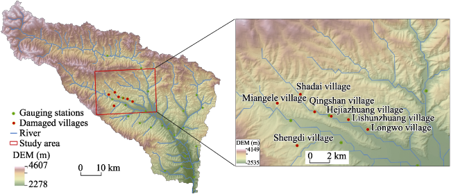
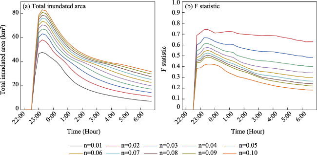
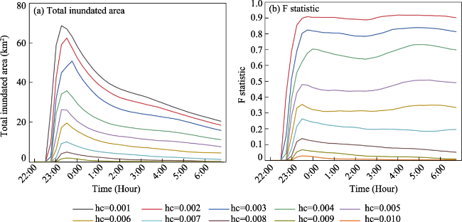
In recent years, research on flash floods has primarily focused on crucial domains, including the examination of spatiotemporal distribution characteristics (Xiong et al., 2019; Zhang et al., 2023), causal analysis (Gao et al., 2006; Liu et al., 2022; Lu et al., 2023), inundation modelling (Cai et al., 2016; Zhang et al., 2016; Zhai et al., 2021; Tang et al., 2022; Song et al., 2023), forecasting and early warning (Liu et al., 2010; Hu et al., 2017; Yin et al., 2022), risk management (Zhu, 2010; Cui et al., 2016; Wang et al., 2016; Zhou et al., 2021), loss assessment (Chen et al., 2021), emergency response (Zhang et al., 2022), and prevention and control measures (Guo et al., 2018), among other pertinent aspects. Flash floods are distinguished from general watershed or urban flooding by their swift and destructive development and evolution. Rapid and accurate inundation simulation modelling plays a critical role not only in enhancing emergency response to flash floods but also in identifying flash flood-prone areas, establishing forecasting and early warning systems, conducting risk assessments, and constructing disaster prevention and mitigation facilities, such as hydraulic engineering projects. Hence, the numerical inundation modelling of flash floods is particularly significant when compared to other research focuses. Currently, the study of dynamic modelling for flash flood inundation commonly relies on singular hydrological or hydraulic models. Rainfall-runoff simulations of flash floods in small watersheds based on distributed hydrological models have been widely applied, and some commonly used models include HEC-HMS, SWAT and TOPMODEL (Liu et al., 2016; Li et al., 2017; Wang et al., 2018). With the continuous development of numerical simulation techniques, various hydraulic models are also being increasingly used in the simulation and analysis of flash flood scenarios, and prominent models, such as flood Area (Liu et al., 2015; Zhang et al., 2018; Chang et al., 2021), MIKE 11 (Wang, 2018) and HEC-RAS (Wu et al., 2016), are now frequently utilized. Nevertheless, standalone hydrological or hydraulic models exhibit inherent limitations in accurately reproducing the complete process of flood occurrence and development, whether in terms of calculating peak flood flow using hydrological models or estimating inundation depth with hydraulic models for flood simulation (Hao et al., 2023). Integrating hydrological and hydraulic models can effectively address these deficiencies, showing the emerging trend in flash flood modelling driven by intense rainfall events (Jiang et al., 2021). Segura et al. (2016) simulated the flash flood event of the Girona River in Spain in 2007 by integrating the hydrological model TETIS with the two-dimensional hydraulic model RiverFlow2D, and the integrated model effectively reproduced the entire process of flood inundation. Hao et al. (2023) performed an inverse simulation of the “7·20” flash flood disaster in Wangzongdian, Henan province, central China, by integrating the FFMS hydrological model with the IFMS two-dimensional hydraulic model, and the outcomes were consistent with the post-disaster investigation report. However, the utilization of irregular grids for terrain representation in this type of hydrological-hydraulic model often leads to complex modelling processes and parameterization, resulting in simulated results that are not sufficiently ideal (Yin et al., 2015).
At present, geographic information system (GIS)-based high-resolution rainfall flood numerical models have emerged as the predominant method for simulating rainfall flooding. Yu et al. (2015) developed the FloodMap-HydroInundation2D model, which enabled the direct integration of the GIS digital terrain elevation data (DEM or Lidar-DSM) to conduct fine-scale simulation of rainfall flooding. Building upon this foundation, Yin et al. (2016b) conducted validation and parameter optimization using the FloodMap model with Shanghai city as a case study. The China Institute of Water Resources and Hydropower Research (CIWHR) independently developed the IFMS/Urban model based on the GIS platform (Xu et al., 2021) in 2015 in cooperation with multiple organizations, and it was successfully applied in flood simulation and forecasting as well as risk mapping projects across various regions in China. Zhang and Pan (2014) proposed a GIS-based urban storm flood simulation method based on the simplification of a distributed hydrological model. Furthermore, in recent years, there has been a growing trend of integrating artificial intelligence with traditional hydrodynamic models to develop flood prediction models (Liu et al., 2022; Xu et al., 2022), and GPU-dominated hydrological models (Ye et al., 2022) and GPU-accelerated nonstructured watershed rainfall flood numerical models (Hou et al., 2021) have emerged. Notably, many of these models leverage GIS for simulation and analysis purposes. These models provide simplicity and convenience in modelling, along with efficient and accurate computations; however, the limitations include the strong dependence on the accuracy of topographic data and the quality of observational data (Yu and Coulthard, 2015), along with insufficient consideration of the dryland river channels and the hydrodynamic conditions of water and sand with high sediment content.
Arid areas generally refer to areas with annual precipitation of less than 600 mm. The northwest region of China is a typical example of an arid area; it is characterized by scarce precipitation, high evaporation rates, short-duration heavy rainfall events, complex underlying surface conditions, significant interannual variability in runoff, and a lower frequency of flash flood disasters compared to more humid regions. This area lacks the construction of perfect flood control engineering facilities, monitoring and warning systems, and a good awareness of disaster prevention. Therefore, arid areas are highly important to select for rapid and accurate flash flood inundation modelling for flash flood disaster prevention and control. In this study, on the study area is Datong county in Qinghai province, Northwest China, the hydrological-hydraulic model FloodMap-HydroInundation2D is used to dynamically and accurately simulate the extent of inundation, depth of flooding, and duration of the “8·18” flash flood disaster that occurred in 2022, and the effect of the model on the actual flood inundation is examined. Moreover, a sensitivity analysis is performed to explore the influential variables that affect the simulation outcomes. The objective is to enhance and advance a reliable and universally applicable numerical simulation methodology for flash flood disasters in small watersheds within arid areas. This research provides substantial scientific evidence and technical support for risk management and prevention of flash flood disasters in China.

2 Materials and methods

2.1 Study area

Datong county is located in the northeast part of Qinghai province, Northwest China, in Hehuang Valley (100°51′E-101°56′E, 36°43′N-37°23′N), at the southern foot of the Qilian Mountains and at Beichuan River basin upstream of Huangshui River, with a total area of approximately 3090 km2. It is the transitional zone between the Tibetan Plateau and Loess Plateau, with an altitude of 2278-4607 m, and the terrain is high in the northwest and low in the southeast (Figure 1). The main soil types are alpine meadow soil, mountain brown soil, chernozem soil and chestnut soil. This region has a plateau continental climate, with an average annual temperature of 4.9℃, an annual precipitation of 523.3 mm (168 d), an annual average evaporation of 1762.8 mm, and most of precipitation occurs in August and the least of it in December.
Figure 1 Location of the study area (Datong county, Qinghai province, Northwest China)
Due to the location of Datong county in the arid region of Northwest China, which has low rainfall and high evaporation, its history has been nearly free of severe flash floods. However, climate change in recent years has led to an increased frequency of extreme and abnormal weather events. In the first half of August 2022, Qinglin township in Datong experienced a cumulative rainfall of 114 mm, which exceeded the August average precipitation over the past 50 years. On the evening of August 17, a sudden heavy downpour occurred in Datong, triggering flash floods and mudslides, which caused river channel shifts; additionally, two townships (Qingshan and Qinglin), seven villages, and 1517 households with 6245 people were affected, two houses were washed away, and 14 houses were damaged. As of 22:00 on August 20, 2022, the flash flood resulted in 25 deaths and 6 people missing, with the rescue of 23 people. The rainfall during this event lasted approximately one hour, and its precipitation intensity was rare in the historical records. In addition, the convergence of intense rainfall in Qinglin and Qingshan, as well as upstream rainfall in Baoku township, led to an increase in surface runoff and a large catchment area, resulting in flash floods over a short period. This rainfall flash flood disaster exhibited the typical characteristics of suddenness, concentrated water volume, and high destructive power. The resulting secondary disasters, such as mudslides and river channel shifts, had a severe impact on public infrastructure and the safety of residents’ lives and property. Therefore, research needs to be performed on the main affected areas of the “8·18” flash flood in Datong county, Qinghai province, Northwest China. The study area primarily includes the whole or partial extent of seven affected villages: Shadai, Qingshan, Hejiazhuang, Lishunzhuang, Longwo, Miangele, and Shengdi, with a total area of approximately 471 km2.

2.2 Data sources

The basic data mainly include the rainfall time series data for the “8·18” event in Datong county, high-precision topographic data of the study area, and on-site inundation data obtained from unmanned aerial vehicle (UAV) imagery. The precipitation data were collected from 23 rain gauge stations in Datong county, the rainfall measurement data was recorded hourly from 22:00 on August 17 to 06:00 on August 18, and the distribution of these rain gauging stations is shown in Figure 1. The high-precision topographic data of Datong county were sourced from the Global 30 m resolution Digital Elevation Model (DEM) data available on the FABDEM (https://data.bris.ac.uk) website; this is currently one of the highest (vertical) accuracy DEMs publicly accessible worldwide. The validation data were obtained from post-disaster UAV observation images from the flash flood disaster in Datong county, Qinghai province, Northwest China; these images were recorded by the Aerospace Information Research Institute of the Chinese Academy of Sciences1(1 http://www.aircas.cas.cn/) on August 18, 2022. The disaster situation data were sourced from the official website of the Datong Hui and Tu Autonomous County Government2(2 http://www.datong.gov.cn/).

2.3 Methods

2.3.1 Flash flood inundation modelling

Modelling floods in mountainous areas with complex underlying surface conditions and considering both hydrological processes (such as precipitation, infiltration, and evaporation) and hydraulic processes (surface runoff) simultaneously poses significant challenges. In this study, we used the FloodMap-HydroInundation2D model (Yu and Coulthard, 2015; Yang et al., 2020), which is a high-precision hydrological-hydrodynamic model based on raster data, to simulate the flash flood inundation in mountainous areas. This model is based on a two-dimensional hydraulic model (FloodMap-Inertial) (Yu and Lane, 2006a; 2006b) and couples the watershed hydrological module (hydrological processes, such as evaporation and infiltration) with the one-dimensional river/pipe network hydraulic module, enabling simulation of the entire process from rainfall to runoff to inundation. Among them, the infiltration process is calculated by the widely used Green-Ampt equation, and the estimation of evapotranspiration is based on the empirical sine curve formula (approximately 3 mm/day) from previous studies (Calder et al., 1983). The simulation of the surface flood evolution is based on the Saint-Venant equations, which describe the non-steady flow of shallow water waves. The model structure is similar to the LISFLOOD-FP model proposed by Bates et al. (2010); however, it uses a different method for calculating the time step and simplifies the momentum equation (convective acceleration term); this results in a simpler model structure with fewer parameters and higher computational efficiency. Moreover, the model incorporates multiple methods for calculating runoff generation and routing; thus, the model is valid for short-duration flash floods and long-term precipitation runoff simulations considering different underlying surface conditions, with strong applicability in both mountainous and urban areas. This model has been applied in various regions, such as Zhengzhou, Shanghai, and New York, and has achieved ideal research results (Yin et al., 2016a; 2016b; Yang et al., 2023). The model utilizes high-resolution DEM data, soil types, and other subsurface information to enable detailed simulation of flash floods in data-scarce regions. The specific model structure and derivation process have been outlined in previous studies (Yu et al., 2016), and the main governing equations of the model on a regular grid are expressed as follows:
q t + Δ t = q t g h t Δ t ( h t + z ) x 1 + g h t Δ t n 2 q t / h t 10 / 3
where
q t + Δ t
is the flow rate at time
t + Δ t
; qt is the flow rate at time t; g is the gravitational acceleration; ht is the water depth at time t; z is the bottom elevation of the grid; and n is the Manning coefficient. Combined with the empirical parameters determined in previous studies and the investigation of relevant literature (Chen and Young, 2006; Yu et al., 2016), the roughness and hydraulic conductivity adopted by the model in the simulation of the “8·18” flash flood inundation are 0.06 and 0.001 m/h, respectively, and the entire Datong flash flood modelling time is set to 9 hours to ensure that the flood inundation process reaches a stable state.

2.3.2 Model verification and sensitivity analysis

Due to the lack of relevant water depth monitoring data, this study does not currently consider using water depth for model verification. Instead, the focus is primarily on the evaluation of the consistency between the predicted inundation extent by the model and the actual inundated areas obtained from real-time aerial images captured by drones.
In addition, the model simulation is often affected by different parameters. In this study, the sensitivity of the model to the surface roughness and soil hydraulic conductivity is primarily explored. In assessing the sensitivity of the model to changes in roughness, 10 simulations were performed using roughness values (Manning coefficient n) ranging from 0.01 to 0.10, with an interval of 0.01. For the assessment of sensitivity to hydraulic conductivity, the permeability coefficient (Ks) was used. The determination of the soil hydraulic conductivity value is highly complex, and existing research methods for determining hydraulic conductivity generally involve laboratory testing, field measurements, or formula inversions. Due to practical limitations, laboratory or field measurements are not suitable for small watersheds in mountainous areas. Therefore, based on the lower range of a typical Ks proposed by Smedema et al. (1983), the range of the soil permeability coefficient in Datong county was estimated by empirical deduction, the saturated hydraulic conductivity value was set to vary between 0.001 and 0.010 m/h, with an interval of 0.001 m/h, and 10 simulations were conducted.
For model validation and sensitivity analysis, the total inundated area and fitting statistic (F) are usually used to evaluate the model effect. The F statistic is used to assess the agreement between the inundated area simulated by the model and the actual observed inundation extent (Yu et al., 2016). The formula is given as follows:
F = A 0 A r + A s A 0
where Ar is the observed inundation area; As is the submerged area simulated by the model; and A0 is the area of the overlap between Ar and As.

3 Results

3.1 Spatial and temporal variation characteristics of rainfall

Figures 2a and 2b show the time series of the rainfall distribution interpolated by 23 rain gauging stations during the “8·18” rainfall event in Datong county. The rainfall began before 23:00 on August 17, and the rainfall was concentrated in the central part of Datong (such as Qinglin and Qingshan townships) at 23:00, with the maximum rainfall in one hour during this period ranging from 20 to 40 mm. Subsequently, the rainfall gradually shifted towards the southeastern part of Datong county, and by approximately 00:00 on August 18, rainfall decreased in the central part of Datong county. This spatial and temporal rainfall distribution effectively aligned with the actual observations. Furthermore, based on the rainfall time series from the three stations with the highest rainfall amounts (Figure 2c), that the total rainfall at the Datong Qinglin township government station, Datong Qingshan township government station, and Datong station was approximately 40 mm, 35 mm, and 44 mm, respectively.
Figure 2 Spatio-temporal distribution of precipitation during the “8·18” storm event that occurred in Datong county (a and b: Spatial and temporal distribution of the peak precipitation; c: Rainfall time series at the three gauging stations with the highest rainfall amount)

3.2 Scenario inundation modelling of the flash flood

The FloodMap-HydroInundation2D model was employed with the 1-hour precipitation data from the gauging station in Datong county, Qinghai province, serving as the hydrological boundary condition input. In the simulation, the most severe flooding scenarios occurring in the study area during a period of 9 hours were selected (from 22:00 on August 17 to 06:00 on August 18). The digital elevation model (DEM) had a resolution of 30 m. The inundation time series maps (Figure 3) generated at hourly intervals showed extensive waterlogging primarily between midnight and 01:00 on August 18. The rapid increase in rainfall resulted in a sharp expansion of the flood-affected areas, with a maximum inundation area exceeding 100 km2 and an average water depth exceeding 0.2 m. After 02:00 on August 18, as the rainfall intensity decreased, the accumulated water began to converge towards low-lying areas, leading to deeper flooding in certain parts of the mountainous region. In some of the lower-lying areas, the water depth surpassed 2 m. By 06:00 on August 18, the highest average water depth reached 0.4 m; however, the extent of inundation gradually decreased due to rainwater infiltration. All the seven villages of Shadai, Qingshan, Hejiazhuang, Lishunzhuang, Longwo, Miangele, and Shengdi were affected to varying degrees. Among them, Qingshan, Hejiazhuang, and Longwo experienced more severe flooding, with maximum water depths exceeding 2 m. The inundation degrees of Shadai, Lishunzhuang, Miangele and Shengdi villages were relatively light.
Figure 3 Time series from the flash flood inundation simulation of the “8·18” storm event that occurred in Datong county
From the maximum inundation distribution map (Figure 4), the inundated water was not concentrated in one village but was widely distributed in all villages, especially in Qingshan, Hejiazhuang and Longwo villages. In terms of the depth of inundation, all seven villages had some degree of inundation, with the highest depths in Qingshan, Hejiazhuang, and Longwo, where the maximum depth of inundation exceeded 2 m. These results were primarily attributed to the relatively lower terrain and proximity to the river for these villages, causing a higher susceptibility for deeper flooding.
Figure 4 Comparison of the predicted and observed inundation areas during the “8·18” storm event in Datong county

3.3 Verification of the model

Figure 4 also shows the comparison between the model-predicted maximum inundation extent and the observed inundation extent. Due to the lack of relevant water depth observation data, in this study, the water depth was not considered for model verification, and the F statistic value was mainly used to evaluate the consistency between the maximum inundation range predicted by the model and the actual inundation area in the post-disaster images recorded by the drones. Moreover, considering the actual disaster situation and the availability of drone observation data, the most severely affected areas of the “8·18” rainfall flash flood disaster in Datong county, Qinghai province, were selected to carry out simulation verification. Based on the drone image observations on August 18, 2022, the actual inundation area delineated within the disaster-stricken region was approximately 43.36 km2, and the model-predicted maximum inundation area was approximately 41.16 km2; additionally, the F-statistic between the two values was calculated to be 0.83 and provided a good fit, and the maximum inundation area predicted by the model was generally consistent with the actual inundation area. In terms of the affected villages, all the three villages of Qingshan, Hejiazhuang and Longwo were in the affected area delineated by the drone imagery observation. These three villages were also included in the model-predicted maximum inundation extent, with the highest water depths and maximum inundation depths exceeding 2 m. This result indicated a relatively severe impact in these villages, further demonstrating the consistency between the model-predicted inundation extent and the actual flooding. Therefore, overall, the model effectively performed in the inundation modelling and in the prediction of flash floods.

4 Discussion

4.1 Sensitivity analysis of the model to roughness and hydraulic conductivity

Roughness and hydraulic conductivity are often the key parameters affecting inundation simulation in flood models. In this study, the two-dimensional hydrological-hydraulic model FloodMap-HydroInundation2D was sensitive to the roughness in the simulation of the flash floods from the heavy rainfall in the small watersheds in arid areas. With the increase in the roughness coefficient, the inundated area gradually increased (Figure 5a), while the F-fit value gradually decreased (Figure 5b). With n=0.01 as the reference base, the maximum inundated area from n=0.02 to n=0.1 increased from 58.11 km2 to 83.12 km2 with a difference of 25.01 km2, while the maximum value of the F-statistic decreased from 0.74 to 0.42 with a difference of 0.32; the change in the F-fit value was more evident because the increase in roughness led to the surface runoff becoming smaller, an increase in the water accumulation, an increase in the inundation area. The difference between the area predicted by simulation and the area of reference simulation became larger, leading to a decrease in the F-fit value. In contrast to the simulation of urban storm flooding, the simulation of the storm flash flooding in small watersheds in arid areas was more sensitive to roughness. Yu et al. (2016) used the FloodMap-HydroInundation2D model to simulate the downtown area of Shanghai, the difference in the maximum inundation area between n=0.02 and n=0.1 in the 30 m DEM simulation and the reference simulation of n=0.01 increased from 2.1% to 9.2%, and the sensitivity of the model to roughness was relatively weak. This result potentially occurred because urban storm flooding was characterized by high rainfall and flat terrain, while mountainous areas received less precipitation and had greater topographic variability.
Figure 5 Time series of the inundated area (a) and F statistic (b) driven by various roughness values

(Note: Simulations with n = 0.01 were used as reference simulations for the F-statistic calculations.)

Compared with the roughness, the model exhibited a stronger sensitivity to hydraulic conductivity. As the hydraulic conductivity increased, the inundated area significantly decreased (Figure 6a), and the goodness of fit also significantly decreased (Figure 6b). With hc=0.001 m/h as the reference benchmark, the maximum inundation area from hc=0.002 m/h to hc=0.01 m/h decreased from 68.67 km2 to 1.88 km2, with a difference of 66.79 km2, and the maximum F-statistic value decreased from 0.92 to 0.03, with a difference of 0.89; this was a significant change. The maximum value of the F-statistic in the simulation of urban storm flooding from hc=0.002 m/h to hc=0.01 m/h (hc=0.001 m/h is the reference simulation) decreased from 0.9 to approximately 0.4, with a difference of approximately 0.5. Therefore, the simulation of the storm flash flooding in arid area subwatersheds was also more sensitive to the hydraulic conductivity than the simulation of the urban storm flooding. This result was mainly related to the characteristics of the arid mountainous soil itself. The hydraulic conductivity is the soil water flux per unit hydraulic gradient, and the saturated hydraulic conductivity tended to show considerable variation in the different areas because of the large spatial variation in relation to factors, such as soil texture, relative density, and pore distribution.
Figure 6 Time series of the inundated area (a) and F statistic (b) driven by the various hydraulic conductivities (Note: Simulations with hc = 0.001 m/h were used as reference simulations for the F-statistic calculations.)

4.2 Time and space evaluation of model simulation

The entire inundation process was dynamically simulated using the two-dimensional hydrological-hydraulic model, FloodMap-HydroInundation2D, and the overall performance of the model simulation and prediction was satisfactory. From the temporal variation in the inundation simulation, widespread flooding occurred primarily from 00:00 to 01:00 on August 18. Subsequently, the inundation gradually decreased due to reduced rainfall and drainage through infiltration, which was consistent with the relevant reports released by the emergency command headquarters for the rescue and disposal of the “8·18” flash flood disaster in Datong county. According to the reports, sudden heavy rainfall occurred in Qinglin township and Qingshan township of Datong at approximately 00:00 on August 18, 2022. The rainfall lasted for approximately one hour, triggering flash floods and debris flows and causing river diversion and overflow; this resulted in significant casualties and property damage. Regarding the spatial distribution of the inundation simulation, the predicted flooded areas closely matched the observed inundation zones from the drone observations, with an obtained F-statistic of 0.83, indicating a good fit.
However, some differences were also observed between the model prediction results and the observed data since some areas within the observed inundation zone were not flooded in the model simulation. The reason for this difference was potentially caused by insufficient resolution of the input global terrain data and errors in rainfall distribution data interpolation. The terrain data inputted into the model was 30-m resolution digital elevation model (DEM) data, and the mountainous terrain was very complex, with large undulations. The 30-m DEM data potentially did not fully capture the local complex terrain; additionally, a higher horizontal and vertical resolution of the DEM correlated to a higher simulation accuracy of the model and a closer flood range of the flash flood event to the actual survey situation. Therefore, insufficiently detailed DEM data was possibly one of the reasons for the prediction error. In addition, the uneven spatial distribution of rainfall station data and the uncertainty caused by interpolation were also important influencing factors. The gauging stations in Datong county were mostly concentrated in the southeast, with uneven distribution, and relatively few rainfall stations were located in the study area. During interpolation, errors in rainfall amounts in different regions could lead to certain differences between the final simulation results and the actual inundation.

5 Conclusions

In this study, the hydrological-hydraulic model FloodMap-HydroInundation2D was utilized to simulate flash flood inundation in small watersheds in arid areas, providing a universal and reliable method and technical support for numerical simulation and prediction of flash flood disasters in small watersheds in arid areas. The results showed that the following: (1) The model could effectively simulate the entire dynamic inundation process of flash flood disasters in small watersheds in arid areas, and the reported flash flood time was consistent with the predicted inundation time. (2) From a spatial perspective, the simulated maximum inundation range was consistent with the observed data, with an F-fit value of 0.83. (3) The model was sensitive to the roughness and hydraulic conductivity in the simulation of flash floods in small watersheds in arid areas, especially to hydraulic conductivity. The above research methods and results could further provide useful references for other small watersheds affected by flash floods.
The occurrence and development process of flash flood disasters are very complex, especially in small watersheds in arid areas. The dynamic simulation of flash flood inundation is influenced by multiple factors, such as data quality and parameter settings, and has strong uncertainty and spatiotemporal variability characteristics. Due to limitations in the data availability and accuracy, this study also has some limitations. Future research can be performed in the following aspects: (1) The results of inverting the spatio-temporal distribution of precipitation using rainfall data obtained from rain gauging stations in this study were not ideal. In the future, more accurate radar rainfall data could be used as input for the model. (2) The installation and maintenance of the hydrological stations in mountainous areas are extremely difficult, resulting in a lack of hydrological data. This study was also limited by the measured water depth data and only considered the observed inundation range to validate the model. In the future, hydrological station observation data (such as flow rate and flow velocity data) could be introduced, and more flood events could be selected for model calibration and validation. (3) When conducting sensitivity analysis of key parameters in the model, our study considered relatively limited parameters. In the future, in addition to roughness and hydraulic conductivity, other important parameters (such as the viscosity coefficient) and water-sediment dynamics conditions could be considered to investigate their effects on flash flood inundation simulation. (4) In subsequent research, a real-time warning system for flash flood disasters in arid areas could be developed, combining pre-disaster forecasting, in-disaster reporting, and post-disaster reporting, to achieve refined management of flash flood risk assessment. In addition, due to the exacerbation of climate change (Ma et al., 2019), future forecasting and warning of flash flood disasters and risk prevention will have greater challenges. Conducting simulation studies of flash flood inundation under future scenarios will provide an important scientific basis for flash flood risk management.
[1]
Bates P D, Horritt M S, Fewtrell T J et al., 2010. A simple inertial formulation of the shallow water equations for efficient two-dimensional flood inundation modelling. Journal of Hydrology, 387(1/2): 33-45.

DOI

[2]
Cai W Y, Liu X P, Zhang J Q, 2016. The study of mountain flood disaster simulation based on distributed SCS model. Journal of Catastrophology, 31(2): 15-18. (in Chinese)

[3]
Calder I R, Harding R J, Rosier P T W, 1983. An objective assessment of soil moisture deficit models. Journal of Hydrology, 60(1-4): 329-355.

DOI

[4]
Chang Z L, Cui Y, Gou X H et al., 2021. Risk and impact zoning of the torrential flood disasters from rainstorm in Shizuishan city based on FloodArea model. Journal of Natural Disasters, 30(4): 191-202. (in Chinese)

[5]
Chen L, Young M H, 2006. Green-Ampt infiltration model for sloping surfaces. Water Resources Research, 42(7): W07420.

[6]
Chen Y, Wang Y, Liu Q A et al., 2021. Study on loss assessment model of flash flood disaster based on land use. Journal of Natural Disasters, 30(2): 52-59. (in Chinese)

[7]
Cui P, Zou Q, 2016. Theory and method of risk assessment and risk management of debris flows and flash floods. Progress in Geography, 35(2): 137-147. (in Chinese)

DOI

[8]
Gao Y Z, Xing J J, Wang C L et al., 2006. Cause and forecast of mountain flood from rainstorm. Journal of Natural Disasters, 15(4): 65-70. (in Chinese)

[9]
Guo L, Ding L Q, Sun D Y et al., 2018. Key techniques of flash flood disaster prevention in China. Journal of Hydraulic Engineering, 49(9): 1123-1136. (in Chinese)

[10]
Guo L, Zhang X L, Liu R H et al., 2017. Achievements and preliminary analysis on China national flash flood disasters investigation and evaluation. Journal of Geo-Information Science, 19(12): 1548-1556. (in Chinese)

[11]
Hao S J, Wang W C, Ma Q et al., 2023. A numerical rehearsal strategy of flash flood disaster with hydrological and hydrodynamic modelling: Case study of “7·20” flash flood disaster in Wangzongdian village, Henan province. Water Resources and Hydropower Engineering, 54(6): 1-11. (in Chinese)

[12]
Hou J M, Zhang Z A, Ma L P et al., 2021. Unstructured numerical model for rainfall-runoff process in watershed based on GPU acceleration technology. Advances in Water Science, 32(4): 567-576. (in Chinese)

[13]
Hu G H, Chen X, Yu Z X et al., 2017. Research on forecast of mountain flood in Chenjiang River Basin based on HEC-HMS model. Journal of Natural Disasters, 26(3): 147-155. (in Chinese)

[14]
IPCC, 2021. Climate Change 2021: The Physical Science Basis. Cambridge: Cambridge University Press.

[15]
Jiang C B, Zhou Q, Shen Y X et al., 2021. Review on hydrological and hydrodynamic coupling models for flood forecasting in mountains watershed. Journal of Hydraulic Engineering, 52(10): 1137-1150. (in Chinese)

[16]
Li R, Zhang S F, 2017. The application and research of Hebei flood model in semi-arid area. Journal of Water Resources and Water Engineering, 28(2): 19-25. (in Chinese)

[17]
Li Z, Gao S, Chen M Y et al., 2022. The conterminous United States are projected to become more prone to flash floods in a high-end emissions scenario. Communications Earth & Environment, 3(1): 86.

[18]
Liu C Z, Huang S, 2022. Research on “7·20” mountain torrents and geological disasters in Zhengzhou city, Henan province of China. Journal of Engineering Geology, 30(3): 931-943. (in Chinese)

[19]
Liu Y, Zhao L L, Ma D, 2016. Applicability research on flood forecasting models for semi-arid and semi-humid areas. Journal of China Hydrology, 36(1): 32-36. (in Chinese)

[20]
Liu Y H, Lu Y R, Zhou Q et al., 2015. GIS raster data-based dynamic flood risk simulation model of Yangzhi ditch in Qinghai province. Journal of China Agricultural University, 20(3): 169-174. (in Chinese)

[21]
Liu Y Y, Liu Y S, Zheng J W et al., 2022. Intelligent rapid prediction method of urban flooding based on BP neural network and numerical simulation model. Journal of Hydraulic Engineering, 53(3): 284-295. (in Chinese)

[22]
Liu Z Y, Yang D W, Hu J W, 2010. Dynamic critical rainfall-based torrential flood early warning for medium-small rivers. Journal of Beijing Normal University: Natural Science, 46(3): 317-321. (in Chinese)

[23]
Lu Y, Huang K H, Hu Y et al., 2023. Analysis of causes and enlightenment of “2020·6·12” flash flood disaster in Zheng’an county, Guizhou province. Journal of Yangtze River Scientific Research Institute, 40(4): 66-72. (in Chinese)

DOI

[24]
Ma D Y, Yin Y H, Wu S H et al., 2019. Sensitivity of arid/humid patterns in China to future climate change under high emission scenario. Acta Geographica Sinica, 74(5): 857-874. (in Chinese)

DOI

[25]
Rozalis S, Morin E, Yair Y et al., 2010. Flash flood prediction using an uncalibrated hydrological model and radar rainfall data in a Mediterranean watershed under changing hydrological conditions. Journal of Hydrology, 394: 245-255.

DOI

[26]
Schroeder A J, Gourley J J, Hardy J et al., 2016. The development of a flash flood severity index. Journal of Hydrology, 541: 523-532.

DOI

[27]
Segura B F, Sanchis I C, Morales H M et al., 2016. Using post-flood surveys and geomorphologic mapping to evaluate hydrological and hydraulic models: The flash flood of the Girona River (Spain) in 2007. Journal of Hydrology, 541(1): 310-329.

DOI

[28]
Smedema L K, Rycroft D W, 1983. Land Drainage: Planning and Design of Agricultural Drainage Systems. London: Batsford.

[29]
Song S K, Wang H L, Lang Z L et al., 2023. Mountain flood simulation of small basin in Taihang Mountains using HEC-HMS Model: A case study of Luluochuan River Basin. Journal of Catastrophology, 38(1): 117-124. (in Chinese)

[30]
Tang C, Zhu J, 2005. A GIS based regional torrent risk zonation. Acta Geographica Sinica, 60(1): 87-94. (in Chinese)

DOI

[31]
Tang W G, Xue F C, Wan J Q et al., 2022. The study on simulation analysis of rainstorm and mountain torrent in mountainous small watershed. Science of Surveying and Mapping, 47(3): 146-156. (in Chinese)

[32]
Wang K, 2018. Flood submerging simulation and evaluation based on MIKE11 in small watershed of hilly regions[D]. Shandong: University of Jinan. (in Chinese)

[33]
Wang L, Ye L, Wu J et al., 2018. Research on multi-hydrological models applicability of flash flood simulation in hilly areas. China Rural Water and Hydropower, (2): 78-84, 90. (in Chinese)

[34]
Wang S, Wu R, Xie W S et al., 2016. Rainstorm-induced mountain flood disaster risk zoning based on FloodArea inundation model: Taking Pihe River Valley as a case. Advances in Climate Change Research, 12(5): 432-441. (in Chinese)

[35]
Wu B, Wang X Z, Zang H F et al., 2016. Mountain torrents inundated area confirmation of villages in Xiaodongchuan River Basin based on HEC-RAS and GIS. Journal of Hydropower Energy Science, 34(9): 52-55. (in Chinese)

[36]
Xiong J N, Li J, Cheng W M et al., 2019. Spatial-temporal distribution and the influencing factors of mountain flood disaster in Southwest China. Acta Geographica Sinica, 74(7): 1374-1391. (in Chinese)

DOI

[37]
Xu W T, Tang W J, Wang X K et al., 2023. Research progress and development trend of heavy rainfall monitoring techniques during flash flood process. Journal of Yangtze River Scientific Research Institute, 40(4): 79-87. (in Chinese)

[38]
Xu Y H, Hu C H, Wu Q et al., 2022. Research on particle swarm optimization in LSTM neural networks for rainfall-runoff simulation. Journal of Hydrology, 608: 127553.

DOI

[39]
Xu Z X, Ye C L, 2021. Simulation of urban flooding/waterlogging processes: Principle, models and prospects. Journal of Hydraulic Engineering, 52(4): 381-392. (in Chinese)

[40]
Yang Y H, Sun L F, Li R N et al., 2020. Linking a storm water management model to a novel two-dimensional model for urban pluvial flood modeling. International Journal of Disaster Risk Science, 11(4): 508-518.

DOI

[41]
Yang Y H, Yin J, Wang D D et al., 2023. ABM-based emergency evacuation modelling during urban pluvial floods: A “7·20” pluvial flood event study in Zhengzhou, Henan province. Science China Earth Science, 66(2): 282-291.

DOI

[42]
Ye X Y, Li Q, Guo Y H et al., 2022. Progress of research on high-performance parallel distributed hydrological model. Progress in Geography, 41(4): 731-740. (in Chinese)

DOI

[43]
Yin J, Gao Y, Chen R S et al., 2023. Flash floods: Why are more of them devastating the world’s driest regions? Nature, 615: 212-215.

DOI

[44]
Yin J, Lin N, Yu D P, 2016a. Coupled modeling of storm surge and coastal inundation:A case study in New York City during Hurricane Sandy. Water Resources Research, 52(11): 8685-8699.

[45]
Yin J, Ye M W, Yin Z E et al., 2015. A review of advances in urban flood risk analysis over China. Stochastic Environmental Research & Risk Assessment, 29(3): 1063-1070.

[46]
Yin J, Yu D P, Yin Z E et al., 2016b. Evaluating the impact and risk of pluvial flash flood on intra-urban road network: A case study in the city center of Shanghai. Journal of Hydrology, 537: 138-145.

DOI

[47]
Yin Z R, Li H X, Tang X et al., 2022. Flash flood forecasting of Shouxi River in Southwestern region based on deep learning. Journal of Hydropower Energy Science, 40(2): 88-91. (in Chinese)

[48]
Yu D P, Coulthard T J, 2015. Evaluating the importance of catchment hydrological parameters for urban surface water flood modelling using a simple hydro-inundation model. Journal of Hydrology, 524: 385-400.

DOI

[49]
Yu D P, Lane S N, 2006a. Urban fluvial flood modelling using a two-dimensional diffusion wave treatment (Part 1): Mesh resolution effects. Hydrological Processes, 20(7): 1541-1565.

DOI

[50]
Yu D P, Lane S N, 2006b. Urban fluvial flood modelling using a two-dimensional diffusion wave treatment (Part 2): Development of a sub grid-scale treatment. Hydrological Processes, 20(7): 1567-1583.

DOI

[51]
Yu D P, Yin J, Liu M, 2016. Validating city-scale surface water flood modelling using crowd-sourced data. Environmental Research Letters, 11(12): 1748-9326.

[52]
Zhai X Y, Guo L, Zhang Y Y, 2021. Flash flood type identification and simulation based on flash flood behavior indices in China. Science China Earth Science, 64(7): 1140-1154.

DOI

[53]
Zhang C Q, Xue F C, Chen X J et al., 2022. Research on route of mountain flood disaster avoidance based on equivalent distance algorithm. Journal of Geo-Information Science, 24(5): 864-874. (in Chinese)

[54]
Zhang L C, Jiang Y A, Liu J et al., 2018. Mountain flood simulation and critical rainfall threshold incurring disaster based on the FloodArea model: A case of Piliqing River Valley as an example. Arid Land Geography, 41(1): 48-55. (in Chinese)

[55]
Zhang M D, Li M, Dai C R et al., 2016. FloodArea modeling of mountain flood in Yunnan province. Journal of Catastrophology, 31(1): 78-82. (in Chinese)

[56]
Zhang Q Z, Lu Y, Yan T J et al., 2023. Temporal and spatial evolution characteristics and influencing factors of mountain torrents in Chongqing. Journal of Changjiang River Scientific Research Institute, 40(7): 80-87, 117. (in Chinese)

[57]
Zhang S H, Pan B H, 2014. An urban storm-inundation simulation method based on GIS. Journal of Hydrology, 517(5): 260-268.

DOI

[58]
Zhou Y, Chen L T, Huang J L et al., 2021. Flash flood disaster risk assessment in Shidu, Beijing under the typical rainfall scenario. Journal of Catastrophology, 36(3): 97-102. (in Chinese)

[59]
Zhu J, 2010. Urban flash-flood risk assessment: A case study in Wenshan city, Yunnan. Geographical Research, 29(4): 655-664. (in Chinese)

Outlines

/