Research Articles

Geomorphology-oriented theoretical framework and construction method for value-added DEM

  • ZHANG Haiping , 1, 2, 3 ,
  • TANG Guoan 1, 2, 3 ,
  • XIONG Liyang , 1, 2, 3, * ,
  • YANG Xin 1, 2, 3 ,
  • LI Fayuan 1, 2, 3
Expand
  • 1. Key Laboratory of Virtual Geographic Environment, Ministry of Education, Nanjing Normal University, Nanjing 210023, China
  • 2. School of Geography, Nanjing Normal University, Nanjing 210023, China
  • 3. Jiangsu Center for Collaborative Innovation in Geographical Information Resource Development and Application, Nanjing 210023, China
*Xiong Liyang, Professor, specialized in geographical information science. E-mail:

Zhang Haiping, PhD, specialized in geographical information science. E-mail:

Received date: 2023-10-12

  Accepted date: 2023-11-20

  Online published: 2024-01-08

Supported by

National Natural Science Foundation of China(41930102)

Abstract

Digital elevation model (DEM) plays a fundamental role in the study of the earth system by expressing surface configuration, understanding surface process, and revealing surface mechanism. DEM is widely used in analysis and modeling in the field of geoscience. However, traditional DEM has the defect of single attribute, which is difficult to support the research in earth system science oriented to geoscience process and mechanism mining. Hence, realizing the value-added data model on the basis of traditional DEM is necessary to serve digital elevation modeling and terrain analysis under the background of a new geomorphology research paradigm and earth observation technology. A theoretical framework for value-added DEM that mainly includes concept, connotation, content, and categories, is constructed in this study. The relationship between different types of value-added DEMs as well as the research significance and application category of this theoretical framework are also proposed. The following are different methods of value-added DEMs: (1) value-added methods of DEM space and time dimensions that emphasize the integration of the ground and underground as well as coupling of time and space, (2) attribute-based value-added methods composed of material (including underground, surface, and ground) and morphological properties, and (3) value-added methods of features and physical elements that consider geographical objects and landform features formed by natural processes and artificial effects. The digital terrace, slope, and watershed models are used as examples to illustrate application scenarios of the three kinds of value-added methods. This study aims to improve expression methods of DEMs under the background of new surveying and mapping technologies by adding value to the DEM at three levels of dimensions, attributes, and elements as well as support knowledge-driven digital geomorphological analysis in the era of big data.

Cite this article

ZHANG Haiping , TANG Guoan , XIONG Liyang , YANG Xin , LI Fayuan . Geomorphology-oriented theoretical framework and construction method for value-added DEM[J]. Journal of Geographical Sciences, 2024 , 34(1) : 165 -184 . DOI: 10.1007/s11442-024-2200-8

1 Introduction

The Digital Elevation Model (DEM) digitally replicates terrain using specific elevation data, effectively capturing surface topography. It is an entity ground model that uses spatial data model to express ground elevation model structurally (Tang, 2014). As the basic data and information source of earth system scientific research, DEM has a wide range of applications in mapping and geographic information data production, digital landform analysis and modeling. For one thing, with the innovation and development of earth observation technology, DEM takes on the characteristics of more extensive data sources, more diverse construction methods, higher data accuracy and faster acquisition frequency (Uysal et al., 2015; Jiang et al., 2017). For another thing, the digital terrain analysis paradigm is transitioning from mere morphological assessments to more comprehensive studies into evolutionary processes and formation mechanisms (Zhou et al., 2006; Yi et al., 2009; Zhu et al., 2009; Xiong et al., 2021).
Overall, these technological and analytical evolutions necessitate a rethinking of the DEM framework. In recent years, with the development of modern earth observation technology, the data source of DEM has gradually shifted from traditional geodetic methods (such as total station and GNSS measurement) to remote sensing-based methods (Deng et al., 2019). This transition has given rise to techniques like photogrammetry, LiDAR, InSAR, and multi-beam measurements33 (Li et al., 2016; Dang et al., 2017; Jiang et al., 2017; David and Martin, 2019; Dong et al., 2021). Notably, UAV-integrated photogrammetry greatly reduces the cost of data acquisition, though vegetation coverage challenges persist. In contrast, LiDAR has the advantages of high precision and resolution. With the advent of multiple echo technology, LiDAR can penetrate vegetation, reducing the impact of vegetation on DEM (Spaete et al., 2011; Lucieer et al., 2014; Uysal et al., 2016). Compared with photogrammetry and LiDAR, InSAR is more suitable for large-scale DEM acquisition and terrain change monitoring (Chen et al., 2017; Tang et al., 2018). These first few methods are suitable for terrain modeling without water body coverage, while for underwater terrain, multi-beam measurement is a commonly used method. However, method selection should align with specific research and task objectives. In general, the rapid development of modern remote sensing earth observation technology has greatly contributed to the development of DEM data acquisition and modeling methods. Various current methods can provide easy access to massive, high-precision, multi-source DEM data, offering strong data support for multi-temporal, multi-level and multi-scale landform modeling, expression and analysis.
At present, although the innovation and development of earth observation technology has greatly enriched the sources of DEM data and improved the data accuracy and so on. However, the construction method of DEM data is still based on the limited elevation sampling data to realize the simulation and expression of continuous terrain surface through spatial interpolation, which is still the most widely used mainstream modeling method of landform morphology (Zhang et al., 2017). Historically, DEM data models have delved into data sampling, modeling interpolation, and accuracy evaluations. The types of DEM data structures mainly include discrete points, contour lines, regular grids, irregular triangular nets, cross-section lines and mixed types (Wang et al., 2004; Liu and Tang, 2006; Liu et al., 2012). Among them, domestic scholars have proposed the data structure categories of landform morphological modeling such as hybrid data structure, multi-level detail data structure and feature embedded data structure (Gong, 1992; Yang et al., 2005; Yue et al., 2007). The research of DEM construction methods, which ranges from the initial interpolation methods based on elevation sampling points, to terrain surface simulation based on map algebra, terrain surface modeling based on high-precision mathematical surfaces taking into account the characteristics of geology, and the construction of high-fidelity digital terrain surfaces implement the construction of DEM data (Larseklundh and Ulrikmårtensson, 1995; Ardiansyah and Yokoyama, 2005; Xun et al., 2012). In addition, some scholars have further studied the local digital terrain surface construction method based on binary spline function and multi-layer surface superposition on the basis of traditional spatial interpolation method (Wang et al., 2008; Chen et al., 2016; Nie et al., 2018; Galin et al., 2019). These strides have significantly bolstered digital terrain modeling’s theoretical underpinnings and methods, enhancing morphological accuracy, broadening modeling methods, and offering a more profound understanding of surface topographies.
However, undeniably, the current DEM data only encapsulate location and elevation information, which can simply express the surface information of landform. Delving deeper into internal landform structures, material compositions, and evolutionary processes remains elusive. Moreover, the geomorphological process is a nonlinear self-organized dynamic evolution system with interwoven material causes and coupled morphological mechanisms, which is often difficult to scientifically express and simulate the geomorphological process by a single morphological mathematical model, and the existing DEM data with a single elevation attribute seriously restricts the in-depth research on geomorphological origin. For example, in the traditional hydrological analysis model based on DEM, the influence of precipitation, surface cover, and soil properties on hydrological processes is ignored (Zhang, 2010; Zeng et al., 2015; Li et al., 2021); in coastal topography modeling, the traditional DEM is difficult to simulate the concave coast and cannot accurately portray the morphological characteristics of the coast, which restricts the construction of related analysis models (Guo et al., 2008; Carlos et al., 2013). Therefore, we urgently need to develop new DEM value-added models that contain multiple geomorphological ontogenetic information to lay the foundation for digital terrain analysis serving topographic data modeling and geomorphological ontogenetic studies.

2 Terrain data modeling requirements for geomorphology

2.1 Geomorphic ontology from the perspective of system theory

The central theme of ontologies delves into understanding the nature of existence. Within the context of geomorphology, an ontology provides a structured and precise representation of concepts intrinsic to this field. By establishing a geomorphology ontology, we aspire to create a bridge for shared comprehension of geomorphological concepts, benefitting both human interpretation and software application. This foundation not only promotes the assimilation and reuse of geomorphological knowledge but also paves the way for novel analyses. Figure 1 displays a logical blueprint of the geomorphology ontology and its practical implementation. By methodically cataloging the morphology, processes, and surrounding environment of landforms, and further encapsulating their characteristics, properties, and influencing factors, we forge an ontological foundation for the landform system.
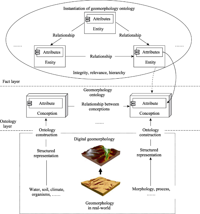
Figure 1 Geomorphology ontology and its instantiation logic diagram
Geomorphology, an essential subject within geography, is aptly perceived as an expansive and intricate system. The characterization of geomorphic systems aligns with the principles of open complex giant systems posited in system theory. These systems are marked by a diverse and tiered subset, intertwined relationships among the different subsets, and an innate openness to external influences (Qian, 1984; Aditi et al., 2019). This openness signifies the perpetual interchange of materials, energy, and information between the landform and its environment, influenced by elements like flowing water, wind, and glaciers (Li and Liu, 1990; Yang et al., 2008). The complexity of landforms is due to the variety of subsystems of landforms, with more than 2400 types of morphogenetic types of landforms in China alone (Zhou et al., 2009), making it a ‘mega-system’ of different subsystems of landforms. This ‘mega-system’ has its own specific structure and interactions, and these interactions imply the causes and mechanisms of landforms. Additionally, it is crucial to perceive landscapes as the culmination of myriad geomorphic processes, reflecting both component interactions and holistic evolution.
Such geomorphic processes are swayed by a spectrum of geographical factors—water, soil, air, biology—and the interplay among them often unfolds in complex, varying magnitudes, culminating in both amplifying and dampening feedback on the geomorphic processes (Semmel, 1993; Wang et al., 1996; Chen and Chen, 2002). The structured representation of these elements and the quantitative modelling of their relationships with the landscape require a sound methodology and effective techniques. Historically, the limitations of human cognition and technology meant that geomorphic modeling and analysis predominantly relied on DEMs that captured surface elevations (Tang et al., 2006). This series of analyses based on single elevation information does not address the fundamental issues of process and mechanism that are of concern in geomorphology. Instead, the fundamental characteristics of the elements associated with landforms, such as wholeness, correlation, hierarchical structure, temporal sequence and dynamic equilibrium, which are emphasized by systems theory, are the main factors that influence the development of landforms. Therefore, a new digital elevation model can be constructed by constructing a conceptual system of landform ontology and structuring it, using the idea of system theory to study the forces of various elements on landforms, and breaking the barrier of traditional digital terrain analysis that makes it difficult to unify different elements into an expression and analysis model.

2.2 Application bottleneck of traditional digital elevation model

Existing studies have proved and proposed a method that can effectively deal with open complex giant systems, that is, a comprehensive integration method combining qualitative and quantitative (Dai and Cao, 2001; Gu and Tang, 2003). Fundamentally, it is to organically combine the expert group (various relevant experts), data and various information sources with computer technology, and combine the scientific theory of disciplines at all levels with people’s experience and knowledge. Under the new research paradigm combining qualitative and quantitative, a new data requirement is put forward for the digital terrain analysis oriented to the origin of geomorphology—multi-dimensional, multi-attribute, and multi-element geomorphological origin information. Currently, digital elevation model (DEM) data primarily encapsulates surface details of landforms, falling short in illustrating the landform’s intrinsic structure, material composition, and its evolutionary trajectory. As a remedy, there is a pressing need to devise a value-added DEM model—one that is multi-attribute, multi-dimensional, and rich in diverse geomorphic origin information. Such a model would aptly cater to the evolving needs of geomorphic research, especially in the era of advanced geoscience analytics, which emphasizes the study of geomorphic origins.
The existing digital terrain analysis focuses on morphology and lacks consideration of internal and external forces and material composition, which has great limitations for in-depth analysis of topography (Tang et al., 2017). While the foundation of such analyses rests upon the digital elevation model, the traditional DEM predominantly represents the terrain field based on elevation, neglecting vital details like subterranean, surface, or above-ground material data, pivotal elements, and other core details instrumental to the understanding of geomorphic evolution. Crucially, these elements do not exist in isolation; they interact within a comprehensive system. In the traditional DEM analysis, even if these elements are considered, the corresponding value-added DEM model is not proposed from the data model research from the perspective of geographic information science (Lv et al., 2017; Hu et al., 2019). In addition, with the enhancement of spatial data acquisition technology such as mapping and remote sensing, multi-source, heterogeneous and massive geomorphic related data become easier. Yet, current DEMs are not sufficiently equipped to encapsulate this wealth of data, which is paramount for a nuanced understanding and analysis of geomorphic processes and mechanisms.

2.3 Construction path of digital elevation model considering geomorphic ontology

Targeting the genesis of geomorphology research, we examine both shared and unique features of geomorphic analysis. Our focus is on understanding the general and specific traits of DEM increments, especially how they vary across different landform types. This involves exploring enhancements in physical and chemical properties like surface materials, abstract attributes such as spatial relationships, and both qualitative features like landform types and quantitative ones like developmental timelines. For any given landform, enhancement depends on analytical goals, expert knowledge, and experience. Recognizing the interplay of morphology with mechanism, statics with dynamics, space with time, and qualitative with quantitative aspects in geomorphology, we propose a value-added model. This model, built on the traditional DEM, crafts a “value-added DEM” that accounts for core geomorphic elements such as time, material, foundational terrain, and the geomorphic developmental timeline.
Geomorphological ontology is the extension of ontology applied in geomorphology, which inherits the main features of ontology. Firstly, geomorphological ontology originates from prior knowledge, needing to construct different levels of Geomorphological ontology through various existing geomorphic knowledge; Secondly, the geomorphological ontology is not modeled with specific various things related to landforms, but with the logical relationship between various related concepts as the main modeling target, forming a logical relationship between concepts. The specificity of spatial data and geographic issues determines that the construction of geomorphological ontology domain needs to depend on a specific spatiotemporal framework. For example, the traditional quantitative analysis of geomorphology takes DEM as a carrier and develops geomorphological researches under the framework of digital terrain analysis, which is widely used. Similarly, geomorphological researches taking into account geomorphological ontology needs to be constructed on a new type of DEM. Oriented to different geomorphic objects and geomorphological problems, specific value-added DEM can be constructed under a unified framework by means of value-added. For example, a digital terrace model can be constructed for terraces while a digital slope model can be constructed for slopes. Both the digital terrace model and digital slope model are both Value-added DEMs after the adding value to DEM. A digital elevation model that takes into account the geomorphological ontology is both necessary for digital terrain analysis in the context of new technologies and a data model basis for knowledge-driven intelligent spatial analysis of geomorphological problems.

3 Theoretical framework of value-added DEM

3.1 Concept and connotation

The DEM is a primary method to digitally represent terrain. While DEM depicts topographic features through elevation characteristics, it restricts the depiction of real-world landforms to just geomorphic attributes. Considering the roots of geomorphology, it addresses not just the surface’s variations and patterns, but also the genesis mechanisms and evolutionary principles (Cheng et al., 2016). Thus, the current DEM only portrays a fraction of the landscape, not fulfilling the advanced needs of geomorphologists and geo-informaticians. Geomorphic processes in the real world are intricate. The topography, genesis, and material composition influence these processes, with combined impacts of spatial progression and temporal evolution (Yin, 1986). In this sense, scientific cognition of landforms requires the introduction of geological information other than topographic features, thus enabling the transition from digital elevation models to digital landform models. In the digital landform model, the role of topographic feature elements, the influence of topographic factors, and the importance of their material composition should be emphasized on the basis of the DEM, and the spatial and temporal integration of the data model should be realized. The transformation from digital elevation model to digital landform model can be realized by adding value to DEM, which includes dimensional value, attribute value and elemental value. Among them, dimensional value-added includes spatial dimensional value-added and temporal dimensional value-added; attribute value-added includes morphological attribute value-added, material attribute value-added and locational attribute value-added; elemental value-added includes topographic feature element value-added and other feature element value-added.
The DEM after adding value by one or more value-added methods can be referred to as the value-added DEM. Drawing from the preceding discussion, a value-added DEM (or VA-DEM) is defined as a model that, rooted in geomorphological origins and driven by knowledge-oriented geographic information analysis, builds upon the traditional DEM. It does so by adding value across spatiotemporal dimensions, incorporating attributes like shape and material, and infusing elements such as geomorphic traits and related features. This enriched spatial data model aids in analyzing surface morphological variations, spatial patterns, genesis mechanisms, and evolutionary processes.
In this study, in view of the limitations of the current DEM mainly expressing the surface morphology through 2 and 2.5 dimensions, as well as the model expression defects of the separation of space and time, it is proposed to increase the value of space dimension and time dimension respectively. Among them, the spatial dimension increment is the layered modeling of the earth’s surface. Specifically, it refers to adding the DEM that only expresses the position and elevation information (H = f (x, y)) in the traditional sense to the true 3D DEM that can express the position and elevation information of different surface layers H = f (x, y, z) at the same time. Similarly, the time dimension increment is to couple the DEMs in different periods into one to build a spatiotemporal DEM data model, so as to increment the DEM traditionally expressing a single time section information into a new spatiotemporal DEM with unified time and space, H = f (x, y, t). A feasible way to realize attribute value-added is to organize the attributes such as surface material, morphology and genesis in a way similar to multi band remote sensing images. The advantage of this processing is that the spatial relationship between attributes and geomorphic units is determined by location. Another implementation idea is to construct the corresponding relationship between attributes and geomorphic units through logical semantic relationship. Element increment is to abstract geomorphic features or other geomorphic related features into points, lines, surfaces, bodies and other elements, embed them into traditional DEM, or directly combine a variety of feature elements into a new data structure. It should be pointed out that among the above three value-added methods, dimension value-added plays a basic role and directly affects the organization of spatial data structure. Attribute increment and element increment can be realized not only based on traditional DEM, but also on DEM after dimension increment.

3.2 Types of value-added DEM and their interrelationships

According to the value-added mode of DEM, the types of value-added DEM are divided into dimension value-added DEM, attribute value-added DEM and element value-added DEM. Among them, dimension increment includes time dimension increment and space dimension increment, attribute increment includes form attribute, material attribute and other increment, and element increment includes form element and feature element and other increment. Each value-added type can generate value-added DEM by direct value-added method (simple value-added method) or composite value-added method. It is worth noting that the order of value-added types sometimes needs to be considered in the composite value-added method. For example, dimension increment is usually performed after attribute increment and element increment, and the order of increment can be exchanged between element increment and attribute increment.
Within the value-enhancement framework of the DEM, the categories of value-added DEM are classified into three main types: dimension-enhanced, attribute-enhanced, and element-enhanced DEMs. Specifically, dimension enhancement encompasses both time and space increments. Attribute enhancement involves adding form and material attributes, among others, while element enhancement emphasizes on form and feature elements, to name a few. Each of these enhancement types can be achieved through a direct enhancement method (a straightforward approach) or a composite enhancement method. When using the composite method, the sequence of enhancements occasionally matters. For instance, dimension enhancement often follows attribute and element enhancements, but the order between attribute and element enhancements can be interchanged.
In the above types of value-added, time and space play a mapping role, that is, a certain spatial position or space-time position has only one Value corresponding to it, while attribute value-added and element value-added do not have this feature. Moreover, the time-dimension value-added and the space-dimension value-added respectively extend the existing two-dimensional DEM in the time dimension and vertical dimension, so as to realize the DEM data model with the coupling of time and space and the integration of the ground and the underground. Many types of attribute value-added can be performed on the existing DEM. Morphological attributes and material attributes are two very important attributes. Whether it is the morphological attributes of plane, transverse section, longitudinal section, first-order and second-order morphological attributes, or single and compound morphological attributes, they all reflect the morphological characteristics of landforms from different aspects. Morphological properties can be calculated directly from the existing DEM, but material properties need to be combined with other knowledge to obtain property information other than the original DEM. The more important properties of material properties include rock composition, soil type, etc. These properties contain important information on the development and evolution of landforms (Zhang et al., 2015). The third value-added method is the value-added of elements, according to whether the elements are part of the landform itself, the elements of the landform are divided into physical elements and ground features. These elements usually have important research significance in the analysis of landforms. For example, the topographic skeleton line, as a physical element, have a controlling effect on the terrain (Zhou et al., 2007); the terraced fields, as a ground feature element, have an influence on the development of the caves, etc. (Jia et al., 2014). Dimension value-added realizes the unified space-time framework of DEM, attribute value-added realizes the information aggregation and spatial coupling of terrain morphological attributes and ground feature attributes, and element value-added realizes the spatial combination of topographic elements and ground feature elements so that they have a complete spatial relationship, and constitute a complete system.
Figure 2 shows a schematic diagram of the value-added DEM types and their relationships. In the 3D value-added DEM model of dimension value-added, attribute value-added and element value-added, the difficulty of different value-added methods is different. Some of these differences come from the ease of access to data sources. For example, for the value-added of time dimension, it is difficult to obtain large-scale and multi-period terrain data in reality. In terms of the value-added of the spatial dimension, there are also certain challenges due to the high acquisition cost of the surface layer information below the ground. Therefore, it is more difficult to increase the value-added of the time dimension and the spatial dimension of DEM. In contrast, it is relatively easy to in crease the value of material attributes. Whether it is attributes such as microclimate above - such as vegetation on the surface, or attributes such as surface soil and underground geological structures, these material attributes are relatively easy to obtain. Morphological attributes are generally based on DEM analysis and exist in the form of terrain morphological factors, so it is relatively easy to obtain. Compared with dimension value-added and attribute value-added, element value-added is easier to achieve. Morphological elements are mainly obtained by extracting characteristic elements based on native DEM data, such as mountain points, saddle points, ridge lines and valley lines. The added value of material elements such as lakes, reservoirs or other artificial elements associated with geomorphological processes is also relatively easy to obtain. To sum up, in terms of the difficulty of data acquisition, the difficulty of dimension value-added, attribute value-added and element value-added decreases sequentially.
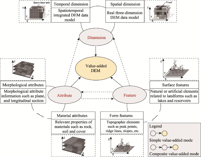
Figure 2 Types of VA-DEM and their relationships

3.3 Research significance and scope of application

The value-added DEM aims to construct a consolidated “value-added DEM” which amalgamates multifaceted data, ranging from elevation to material, spatial to temporal, surface to subsurface, and static to dynamic elements. This endeavor facilitates an evolution in terrain data mapping, updating current data models and paving the way for next-generation digital terrain analysis. Following this, the new data model will usher in methodological innovations. Traditional digital topographic techniques, largely centered around topographic variables and feature extraction, often miss tapping into the profound essence inherent in conventional geomorphological research and thought processes. Consequently, they come up short in unearthing deep geomorphic insights and in unraveling the intrinsic geographical principles guiding geomorphic phenomena through mere surface morphology evaluation. The value-added DEM paves the way for a reimagined digital terrain analysis approach, emphasizing a holistic examination of surface morphology, quantitative exposition of spatial layouts, and a scientific deconstruction of mechanism processes.
The applications of DEM increment encompass the adoption of the novel DEM data model in cartography and pioneering digital terrain evaluation in the realm of geographic information science. More specifically, it introduces a cutting-edge digital terrain analysis method that harmoniously integrates surface and subsurface data, weaves together time and space, synchronizes mechanisms with processes, and merges micro-level details with macro perspectives. This methodology not only propels the advancement of the DEM but also transitions digital terrain analysis from a mere examination of landforms to an exploration of underlying geomorphic processes. Furthermore, leaning on the rich data concerning landform morphology and processes, knowledge-driven intelligent digital terrain analysis devises a spatial reasoning model and a landform knowledge method anchored in map-based modes. The value-added DEM, in this context, offers the foundational data model crucial for bringing this model and method to fruition.

4 Construction method of value-added DEM

4.1 Dimension-based value-added method of DEM: Taking the terrace as an example

DEM dimension increment includes spatial dimension and time dimension increment. The two increment methods have the same construction idea, but there are differences in connotation. The spatial dimension’s objective is to elevate the conventional 2.5D spatial data model to an authentic 3D model, transitioning the traditional DEM from a 2.5D representation to a full 3D visualization. In contrast, the temporal dimension seeks to sequence digital elevation data over time, achieving a harmonization of both space and time. This progression evolves the conventional spatial-only model to a combined space-time representation, ideal for crafting algorithms that integrate both dimensions. The modeling of terraces is a typical application in space dimension and time dimension increment. This paper proposes the idea and method of DEM dimension increment by terrace modeling. River terraces, integral to fluvial geomorphology studies, harness the power of the DEM to dissect various terracing challenges.
The evolution of a river terrace is an extended chronological process. One can simulate its stratigraphic material constitution to forge a 3D representation and ascertain its age for a space-time modeling. Such endeavors pave the way for both spatial and temporal increments of river terraces. The foundation for such digital modeling invariably rests on DEM. Figure 3, for instance, unveils the outcomes of a river terrace dimension increment.
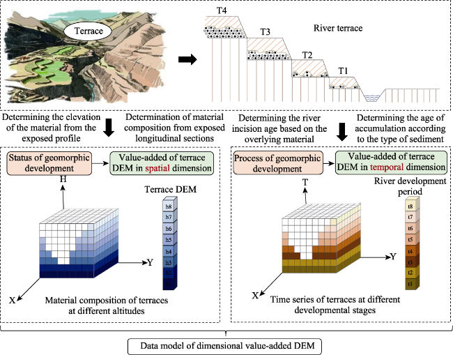
Figure 3 Dimension-based VA-DEM for terrace modeling (digital terrace model)
Securing 3D surface topographic data presents challenges due to the intricacies in obtaining sampling points across various depths using drilling techniques. In the context of river terraces, however, one can directly extract material samples from the manifest longitudinal profile, recording the absolute elevations of these sampling points (Gao et al., 2020). Leveraging this approach, a 3D DEM can be designed to depict river terrace evolution and the diversity of surface material compositions, embodying the spatial dimension increment. Concurrently, by assessing the overlying materials of a river terrace, one can determine the river’s incision age, and the sediment type can hint at the sediment’s age, enabling the determination of the formation age for different stratigraphic layers (Jiang et al., 2020, 2021). This foundation facilitates the crafting of a space-time DEM, capturing the river terrace’s evolution and signifying the temporal dimension increment. The river terrace dimension outcome embodies not only a shift from a 2D to a 3D spatial representation but also encapsulates the material composition across various stratigraphic layers. This means the spatial dimension increment of DEM inherently possesses elements of attribute increment, which will be elaborated upon in the succeeding segment. If a river terrace enriched with spatial or temporal dimensions further incorporates attribute and element increments, it elevates DEM from mere topographic portrayal to a cartographic relief generalization. Such a comprehensive representation, rooted in the conventional DEM for river terraces, can be aptly termed as the “digital terrace model”.
As the dimensional value-added needs to be transformed from a 2D DEM in the traditional sense to a 3D DEM expressing different surface layers and a spatiotemporal DEM expressing spatiotemporal features, the traditional regular grid and irregular grid DEM data structures can hardly meet the data structure expression needs of the above two value-added DEMs, and therefore a multi-dimensional data structure is required. At present, there are two main types of multi-dimensional DEM data structures based on the grid approach, namely the voxel data structure based on the spatiotemporal (3D) cube and the TIM data structure based on irregular triangles (Nonogaki et al., 2021). As the voxel structure not only inherits many advantages of the raster data structure in terms of storage structure and spatial analysis, but also facilitates 3D and spatiotemporal interactive visualization, the dimensional value-added DEM proposed in this study uses three-dimensional voxels and spatiotemporal voxels to realize the spatial dimensional value-added and temporal dimensional value-added of the DEM.

4.2 Attribute-based value-added method of DEM: Taking the single slope as an example

DEM attribute value-added mainly includes morphological attribute and material attribute value-added two ways, other ways also include location attribute and other value-added. Although the contents of attribute value-added are different, the value-added methods are the same. Morphological attributes mainly refer to various terrain factors obtained based on traditional DEM extraction. These terrain factors are called morphological attributes because most of them are obtained directly or indirectly based on elevation information, which is the basic variable to express and reveal the surface morphology. Since there are hundreds of existing terrain factors, which are numerous and rich in types, and these terrain factors reflect various features of topographic landscapes from different aspects, adding value to the morphological attributes of traditional DEMs is of great significance for digital terrain analysis from geomorphological origin (Eltner et al., 2016). In addition to morphological attributes, various materials above, on and below the ground can also have an important influence on geomorphologic evolution, such as precipitation above the ground, soil and vegetation on the surface, and rocks below the ground. Therefore, there is also a need to add value to the material properties of the conventional DEM. The DEM data model and its data structure after morphological attributes, material attributes value-added and other attributes value-added are more conducive to the quantitative analysis of geomorphological problems from an integrated perspective. The following is an example of the attribute value-added method of DEM for sloping land.
As a basic geomorphological unit, slope land is mainly used as DEM in the process of digital representation and modeling. In the past, various studies on slope land-related issues were also conducted mainly based on conventional DEM. However, the formation and development of sloping land is not only related to the slope morphology itself, but also influenced by various materials in the subsurface, surface and ground (Jia et al., 2004). As a result, traditional DEMs are unable to meet the needs of in-depth studies of geomorphological problems such as slopes. If the above material properties are incorporated directly into the DEM model itself as part of the DEM, the construction of a value-added DEM that takes into account material composition, morphological structure and locational characteristics will greatly enhance the value of the DEM in quantitative geomorphological analysis. This value-added DEM for the digital representation of slopes can be referred to as a digital slope model, as illustrated in Figure 4, which shows the value-added attributes for slope modelling. In this digital slope model, three types of value-added attributes are included: slope form, slope quality and slope position. The morphological attributes correspond to the slope shape attributes. Slope form is the morphology of a slope, which contains properties such as slope, slope direction, slope type and slope length. Physical properties correspond to slope quality properties. Slope quality refers to the nature of lithological structure, material composition and climatic environment of the slope underground, on the surface and above ground. Location attributes correspond to slope position attributes. The so-called slope position attributes, i.e. the locational relationships in which slopes are located, can be divided into natural and human locational attributes. The locational relationship of a slope mainly represents the location and layout of the slope and its position in relation to the surrounding geographical objects.
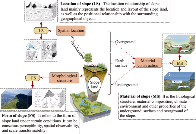
Figure 4 Attribute-based VA-DEM for hillslope modeling (digital hillslope model)
Just as the elevation, any attribute used for value-added has a value in each pixel of traditional DEM. Although regular grid DEM is widely used, it cannot be directly used to implement a unified model based on multiple attributes. Therefore, this paper proposes a multi-dimensional raster structure to implement the attribute-based value-added of traditional DEM, and its data structure can be called a raster structure with multi-dimensional attribute. The advantages of using a raster structure with multi-dimensional attribute are mainly reflected in the following aspects:1) It inherits the advantages of raster data structure in data compression, data storage and spatial analysis. 2) It is easy to convert a multi-dimensional raster structure into a multi-dimensional voxel structure, which is conducive to exploratory spatial data analysis based on interactive visualization. 3) The raster structure with multi-dimensional attribute determines the spatial relationship between the value-added attribute set and the traditional DEM through the spatial location, which is conducive to the implementation of various digital terrain analysis models.

4.3 Feature-based value-added method of DEM: Taking complex slopes as an example

The feature-based VA-DEM mainly includes the value-added of surface features and the value-added of form features. The surface features include objects that are naturally formed or created by human life related to topography. The form features refer to the elements that are used to characterize the morphological features of the terrain, which are measured in reality or extracted from traditional DEM. In traditional digital terrain analysis, many studies have introduced various surface features and form features, but they have not integrated these features into the DEM as part of the DEM. Since the DEM is used as the carrier for different surface features and form features after digital modeling, there are various explicit and invisible spatial relationships. If these elements are not integrated into the DEM, it will be difficult to construct a unified analysis model that takes into account the spatial relationship between these features and the impact on the development of the topographic feature. This will seriously hinder the development of digital terrain analysis methods and lead to existing digital terrain analysis is difficult to solve the original problems of geomorphology. Therefore, it is urgent to build a feature-based VA-DEM based on the needs of digital terrain analysis and the problems existing in the data structure of traditional DEM. The following will take the watershed as an example to illustrate the method of the feature-based VA-DEM.
Hydrological analysis is a typical application of GIS data modeling and spatial analysis in watershed research, which is of great significance to watershed modeling (Zhang and Zhou, 2017). Traditional digital watershed analysis is mainly based on the morphological characteristics and gravity mechanism of the watershed DEM, extracting slope units and various morphological features and factors, and carrying out related analysis and simulation studies (Wang et al., 2002; Li and Zhou, 2014). Such as watershed extraction, flow process simulation and river network analysis, etc. However, as emphasized in this paper, traditional digital watershed modeling and analysis does not integrate various form features of watershed into the watershed data model, but only uses its connectivity in the process of watershed network analysis. While simulating the water flow process, although they consider the effect of valley network connectivity and morphological fluctuations on the flow direction and velocity, the data model does not integrate various features with the DEM, and there is no spatial relationship at the data structure level. However, the topological relationship, elevation relationship, azimuth relationship and location relationship among different features in the digital watershed have an important influence on the simulation process. More importantly, some artificial and natural features that have a profound impact on the short-term flow process and the long-term watershed landform development process are rarely embedded in the data model. Based on the above problems, this paper proposes a method of the feature-based to build a value-added watershed DEM.
Figure 5 shows a schematic diagram of element value-added for basin-oriented modeling. The characteristic elements of the watershed mainly include ground feature elements and shape elements. Among them, the ground feature elements include natural features and artificial features. Lakes and waterfalls are typical natural features, while reservoirs and dams are artificial features, and these features have an important impact on the development of watersheds. According to the analysis needs, these features can be abstracted into point or polygon features. For example, when waterfalls or reservoirs are viewed as features that affect the flow and resistance of water in a valley network of watersheds, they can be viewed as point features. However, it can be modeled as a polygon feature when viewed as a polygon that affects the watershed valley erosion datum. The morphological elements mainly refer to the dominant and recessive elements that represent the characteristics of the slope and ditch in the watershed. For example, gully heads and water outlets in a gully network can be abstracted by point features, channel and watershed boundaries can be represented by line features, and slope units, watersheds, and sub-watersheds can be digitized as polygon features. These are all morphological elements, which characterize the physical characteristics of the slope and ditch of the watershed. By integrating the traditional watershed DEM with various watershed-related ground features and morphological elements, and constructing a unified data model, the value-added of the watershed DEM can be realized. The value-added digital watershed can be called a digital watershed model.
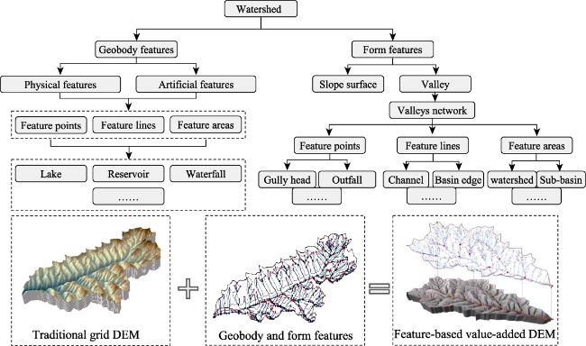
Figure 5 Feature-based VA-DEM for watershed modeling (digital watershed model)
Different from the 3D spatial voxel data structure and spatiotemporal voxel data structure of dimensional increment DEM, and from the multi-dimensional raster data structure after attribute increment, factor increment is more suitable for vector data structure such as irregular grid and element network. This paper believes that although the traditional DEM is mainly constructed by regular grids, the value-added elements proposed in this paper are more suitable to be expressed by the object model that emphasizes the individual, so the vector data structure is used. The element value-added DEM data model proposed in this paper is essentially different from the feature-embedded DEM data model proposed in the past. The main difference is: On the one hand, the DEM of feature embedding directly embeds the feature elements into the DEM to make the morphological features more realistic, so as to achieve the effect of high-fidelity DEM (Carrara et al., 1997). The element value-added DEM embeds the shape feature elements and the ground feature elements, mainly to emphasize its spatial relationship and its coupling relationship with the terrain. In addition, the element value-added DEM also includes the value-added of recessive feature elements; On the other hand, the new DEM formed by DEM element increment maintains the unity of various ground feature elements and traditional DEM in data structure, but also maintains a high degree of independence in attribute characteristics. That is, different feature elements may have different attribute structures and attribute values.

5 Conclusion

In the context of current modern earth observation technology, traditional DEMs are insufficient for the demands of modern surveying, mapping, and knowledge-driven earth science research in the AI era., On the basis of the traditional DEM model with elevation as the basic information, consider the integration, unified expression and storage of underground, surface and above-ground material composition and other related geographic information and ground feature elements, so as to realize the dimension value-added, attribute value-added and element value-added of DEM. The traditional DEM only reflects the surface relief and is not enough to support the topographic analysis oriented to the origin of geomorphology. Therefore, it is necessary to study the value-added model of DEM, so that it cannot only reflect the morphological characteristics, but also reflect the original content of geomorphology such as geomorphological mechanism and process, spatial structure and distribution law.
This paper proposes a theoretical framework for adding value to DEM, starting from the current real-world demand for DEMs in the field of surveying and mapping and GIS and the main problems faced by the construction of new DEM. It is believed that traditional DEM should be added value from three aspects: dimension, attribute and element. In terms of dimension value-adding, focusing on the value-added of spatial and temporal dimensions, to realize real 3D or space-time-dimension DEM. Taking the digital terrace model as an example, it explains the concept model of digital terrace that adopts the value-added of space and time dimensions based on traditional DEM; Attribute value-adding mainly focuses on material attributes and morphological attributes, constructs a multi-attribute DEM, and explains the conceptual model of attribute dimensional value-added to build digital terrace model; The value-added of features is mainly based on the value-added of ground features and morphological features, constructs a multi-feature DEM, and uses the digital watershed as an example to explain its conceptual model.
The current value-added of DEM at the temporal and spatial dimension level will provide a dimensional increase method for the construction of a new DEM data model under the temporal and spatial GIS framework, and provide a possibility for the traditional digital terrain analysis to take into account the composition of underground materials and the dynamic process of the surface. Spatiotemporal data models such as 3D voxels and spatiotemporal voxels can be constructed. In addition, the value-added of DEM at the level of morphological properties and material properties enables the addition of subsurface, surface and above-ground material properties that affect the geological process, as well as various morphological properties of traditional DEM in the construction of DEM. This value-added method provides support for digital terrain analysis that integrates morphology and process, and such value-added can be achieved by means of multi-dimensional attribute grids. Furthermore, the value-added of DEM at the level of physical and characteristic elements is the geophysical objects related to the geomorphological process or the morphological characteristics that affect the geomorphic process. Through elements such as points, lines and areas, a value-added DEM is constructed, showcasing relative independence between distinctive features and sharpened spatial relationships.
While this paper offers a theoretical framework of value-added DEM and the construction methods at three different levels, and explains the corresponding data structure and application scenarios such as digital terrace model, digital slope model and data watershed model. However, due to the high requirements of spatial data structures in terms of data storage efficiency, spatial analysis complexity and visualization, as well as the diversity and complexity of requirements for digital landform modeling and analysis in the field of geomorphology, the construction of value-added DEMs also requires conceptual models, data structure and application scenarios to carry out more in-depth research in order to serve the data model requirements for the production of surveying and mapping terrain data and the research on major scientific issues in geomorphology.
[1]
Anette E, Andreas K, Carlos C et al., 2016. Image-based surface reconstruction in geomorphometry: Merits, limits and developments. Earth Surface Dynamics, 4(4): 359-389.

DOI

[2]
Ardiansyah P, Yokoyama R, 2002. DEM generation method from contour lines based on the steepest slope segment chain and a monotone interpolation function. ISPRS Journal of Photogrammetry & Remote Sensing, 57(1): 86-101.

[3]
Carlos H, André O, 2013. Influence of cell size on volume calculation using digital terrain models: A case of coastal dune fields. Geomorphology, 181(1): 130-136.

[4]
Carrara A, Bitelli G, Carla R, 1997. Comparison of techniques for generating digital terrain models from contour lines. International Journal of Geographical Information Science, 11(5): 451-473.

DOI

[5]
Chen C, Liu F, Yan C et al., 2016. A Huber-derived robust multi-quadric interpolation method for DEM construction. Geomatics and Information Science of Wuhan University, 41(6): 803-809. (in Chinese)

[6]
Chen X, Chen Y, 2002. Hydrological change and its causes in the river network of the Pearl River Delta. Acta Geographica Sinica, 57(4): 429-436. (in Chinese)

DOI

[7]
Cheng W, Liu Q, Shen Y, 2016. Research progress and effect of geomorphology based on projects supported by the National Natural Science Foundation of China. Acta Geographica Sinica, 71(7): 1255-1261. (in Chinese)

DOI

[8]
Cheng W, Zhou C, Shen Y et al., 2017. Retrospect and perspective of geomorphology researches in China over the past 40 years. Acta Geographica Sinica, 72(5): 755-775. (in Chinese)

DOI

[9]
Dai R, Cao L, 2001. Open complex giant system. Journal of Systems Engineering, 16(5): 376-381. (in Chinese)

[10]
Dang Y, Zhang C, Zhou X et al., 2017. Shoreline surveying method based on the stereo imaging and mapping. Bulletin of Surveying and Mapping, 11: 47-50. (in Chinese)

[11]
David K, Martin M, 2019. Glacial geomorphology of the Šumava/Bayerischer Wald Mountains, Central Europe. Journal of Maps, 15(2): 719-725.

DOI

[12]
Deng F, Rodgers M, Xie S et al., 2019. High-resolution DEM generation from spaceborne and terrestrial remote sensing data for improved volcano hazard assessment: A case study at Nevado Del Ruiz, Colombia. Remote Sensing of Environment, 23(3): 111-134.

[13]
Dong Y, Zhang L, Hou J et al., 2021. Cascaded multi-baseline interferometry with bistatic TerraSAR-X/TanDEM-X observations for DEM generation. ISPRS Journal of Photogrammetry and Remote Sensing, 171: 224-237.

DOI

[14]
Eklundh L, Mårtensson U, 1995. Rapid generation of digital elevation models from topographic maps. International Journal of Geographical Information Systems, 9(3): 329-340.

DOI

[15]
Gaki S, Masumoto S, Nemoto T et al., 2021. Voxel modeling of geotechnical characteristics in an urban area by natural neighbor interpolation using a large number of borehole logs. Earth Science Informatics, 14(1): 1-12.

DOI

[16]
Galin E, Guérin E, Peytavie A et al., 2019. A review of digital terrain modeling. Computer Graphics Forum, 38(2): 553-577.

DOI

[17]
Gao H, Li Z, Liu F et al., 2020. Terrace formation and river valley development along the lower Taohe River in central China. Geomorphology, 348: 106-185.

[18]
Gong J, 1992. An unified data structure based on linear quadtrees. Acta Geodaetica et Cartographica Sinica, 4: 259-266. (in Chinese)

[19]
Gu J, Tang X, 2003. Some developments in the studies of meta: Synthesis system approach. Systems Science and Systems Engineering, 15(3): 112-125.

[20]
Guo W, Li S, Zhu D, 2009. The application of geographic information technology to coastal geomorphology. Acta Oceanologica Sinica, 28(5): 49-57.

[21]
Hu G, Xiong L, Tang G et al., 2019. Vector geometry-based method for the extraction of slope of aspect by using DEMs. Acta Geodaetica et Cartographica Sinica, 48(11): 1404-1414. (in Chinese)

[22]
Jia L, Gao J, Zhang Y et al., 2014. Analysis of rainstorm erosion disaster in terrace field in loess hilly and gully region. Research of Soil and Water Conservation, 21(4): 7-11. (in Chinese)

[23]
Jia Y, Zheng F, Yang Q et al., 2004. Review on hillslope erosion prediction models in China. Research of Soil and Water Conservation, 11(4): 109-112. (in Chinese)

[24]
Jiang G, Nie Q, Chen X, 2017. Key technologies analysis of DEM production based on LiDAR data. Bulletin of Surveying and Mapping, 6: 90-93. (in Chinese)

[25]
Jiang X, Chen W, Ning F et al., 2020. Sediment characteristics of terraces in Wudang Basin and their implications on basin evolution. Geographical Research, 39(6): 1242-1254. (in Chinese)

DOI

[26]
Jiang X, Chen W, Ning F et al., 2021. River terraces in the northern Guizhou Plateau and their implications for karst landform evolution. Geographical Research, 40(1): 81-92. (in Chinese)

DOI

[27]
Li A, Bian J, Zhang Z et al., 2016. Progresses, opportunities, and challenges of mountain remote sensing research. Journal of Remote Sensing, 20(5): 1199-1215.

[28]
Li A, Zhang X, Liu B, 2021. Effects of DEM resolutions on soil erosion prediction using Chinese Soil Loss Equation. Geomorphology, 384: 107706.

DOI

[29]
Li J, Zhou Z, 2014. Landscape pattern and hydrological processes in Yanhe River basin of China. Acta Geographica Sinica, 69(7): 933-944. (in Chinese)

DOI

[30]
Li L, Liu S, 1990. Preliminary investigation on structures and functions of urban geomorphological system. Journal of Southwest Teachers University, 15: 607-613. (in Chinese)

[31]
Liu A, Tang G, 2006. DEM based auto-classification of Chinese landform. Journal of Geo-Information Science, 8(4): 8-14. (in Chinese)

[32]
Liu J, Philippa J, Eric Y et al., 2012. GIS modelling of earthquake damage zones using satellite remote sensing and DEM data. Geomorphology, 139(5): 18-535.

[33]
Lucieer A, Turner D, King D et al., 2014. Using an Unmanned Aerial Vehicle (UAV) to capture micro-topography of Antarctic moss beds. International Journal of Applied Earth Observation & Geoinformation, 27(4): 53-62.

[34]
Lv G, Xiong L, Chen M et al., 2017. Chinese progress in geomorphometry. Journal of Geographical Sciences, 27 (11): 1389-1412.

DOI

[35]
Mishra A, Dixit S, Choudhary S et al., 2019. Forensic genetic analysis of the population of Gujarat with Power Plex 21 multiplex system. Forensic Science International: Genetics Supplement Series, 7(1): 167-168.

[36]
Nie L, Shu H, Liu Y, 2018. Interpolation of monthly average temperature by using geographically weighted regression kriging in the complex terrain region. Geomatics and Information Science of Wuhan University, 43(10): 1553-1559. (in Chinese)

[37]
Qian X, 1984. Scientific Method and Philosophical Issues in System Theory. Beijing: Tsinghua University Press, 4-29.

[38]
Semmel A, 1993. Soil geomorphology. CATENA, 20(6): 597-598.

DOI

[39]
Spaete L, Glenn N, Derryberry D et al., 2011. Vegetation and slope effects on accuracy of a LiDAR-derived DEM in the sagebrush steppe. Remote Sensing Letters, 2(4): 317-326.

DOI

[40]
Tang G, 2014. Progress of DEM and digital terrain analysis in China. Acta Geographica Sinica, 69(9): 1305-1325. (in Chinese)

DOI

[41]
Tang G, Liu X, Fang L et al., 2006. A review on the scale issue in DEMs and digital terrain analysis. Geomatics and Information Science of Wuhan University, 31(12): 1059-1066. (in Chinese)

[42]
Tang G, Na J, Cheng W, 2017. Progress of digital terrain analysis on regional geomorphology in China. Acta Geodaetica et Cartographica Sinica, 46(10): 1570-1591. (in Chinese)

DOI

[43]
Tang X, Li T, Gao X et al., 2018. Research on key technologies of precise InSAR surveying and mapping application using automatic SAR imaging. Acta Geodaetica et Cartographica Sinica, 47(6): 730-740.

DOI

[44]
Uysal M, Toprak A, Polat N, 2015. DEM generation with UAV photogrammetry and accuracy analysis in Sahitler Hill. Measurement, 73: 539-543.

DOI

[45]
Wang J, Cui T, Miao G, 2004. Digital elevation model and data structure. Hydrographic Surveying and Charting, 3: 1-4. (in Chinese)

[46]
Wang J, Xi P, Liu Z et al., 1996. Cenozoic climatic and topographical changes in the western Qaidam Basin. Geological Review, 2: 166-173. (in Chinese)

[47]
Wang Y, Zhu C, Wang Z, 2008. A surface model of grid DEM based on Coons surface. Journal of Geodesy and Geoinformation Science, 37(2): 217-222. (in Chinese)

[48]
Wang Z, Liu C, Zuo Q et al., 2002. Methods of constructing distributed hydrological model based on DEM. Progress in Geography, 21(5): 430-439. (in Chinese)

DOI

[49]
Xiong L, Tang G, Yang X et al., 2021. Geomorphology-oriented digital terrain analysis: Progress and perspectives. Journal of Geographical Sciences, 31(3): 456-476.

DOI

[50]
Xun S, Girod L, Long R et al., 2012. A comparison of LiDAR-based DEMs and USGS-sourced DEMs in terrain analysis for knowledge-based digital soil mapping. Geoderma, 170(1): 217-226.

DOI

[51]
Yang B, Shi W, Li Q, 2005. An integrated TIN and Grid method for constructing multi-resolution digital terrain models. International Journal of Geographical Information Science, 19(10): 1019-1038.

DOI

[52]
Yang X, Shi C, Li B et al., 2008. Some aspects about Chinese geomorphology: Recent progresses from an earth system science perspective. Quaternary Sciences, 4: 521-534. (in Chinese)

[53]
Yi R, Chen J, Deng M et al., 2009. An approach for the design of loess geomorphology ontology. Geography and Geo-Information Science, 25(2): 46-49. (in Chinese)

[54]
Yin G, 1986. The tendency and variation of landform development. Acta Geographica Sinica, 41(3): 241-253. (in Chinese)

[55]
Yue T, Du Z, Song D et al., 2007. A new method of surface modeling and its application to DEM construction. Geomorphology, 91(1): 161-172.

DOI

[56]
Zeng C, Stephen B, Luce J et al., 2015. A natural-rule-based-connection (NRBC) method for river network extraction from high-resolution imagery. Remote Sensing, 7(10): 14055-14078.

DOI

[57]
Zhang F, Zhou Q, 2017. Application progress of terrain analysis in watershed hydrologic modeling. Geography and Geo-Information Science, 33(4): 8-15. (in Chinese)

[58]
Zhang H, Zhou X, Dai W, 2017. A preliminary on application analysis of spatial interpolation method. Geography and Geo-Information Science, 33(6): 14-18, 105. (in Chinese)

[59]
Zhang J, Li Q, Gong H et al., 2010. Hydrologic information extraction based on arc hydro tool and DEM. 2010 International Conference on Challenges in Environmental Science and Computer Engineering, 1: 503-506.

[60]
Zhang W, Fu Y, Liu B et al., 2015. Geomorphological process of late Quaternary glaciers in Kanas River Valley of the Altay Mountains. Acta Geographica Sinica, 70(5): 739-750. (in Chinese)

DOI

[61]
Zhou C, Cheng W, Qian J et al., 2009. Research on the classification system of digital land geomorphology of 1:1000000 in China. Journal of Geo-Information Science, 11(6): 707-724. (in Chinese)

DOI

[62]
Zhou H, Sun J, Turk G et al., 2007. Terrain synthesis from digital elevation models. IEEE Transactions on Visualization and Computer Graphics, 13(4): 834-848.

PMID

[63]
Zhou Q, Liu X, 2006. Adding value to spatial data-taking digital terrain analysis as an example. Geomatics World, 3: 4-13. (in Chinese)

[64]
Zhu C, Peng H, Li Z et al., 2009. Age and genesis of the Danxia landform on Jianglang Mountain, Zhejiang province. Journal of Geographical Sciences, 19(5): 615-630.

DOI

Outlines

/