Research Articles

Human settlements in the Ordos Plateau since the Neolithic Age

  • WEN Penghui , 1, 2 ,
  • WANG Nai’ang , 2 ,
  • LI Mingjuan 2 ,
  • CHENG Hongyi 2 ,
  • NIU Zhenmin 2, 3
Expand
  • 1. College of History and Culture, Wooden Slips Research Academy, Northwest Normal University, Lanzhou 730070, China
  • 2. College of Earth and Environmental Sciences, Center for Glacier and Desert Research, Lanzhou University, Lanzhou 730000, China
  • 3. School of Geography and Planning, Ningxia University, Yinchuan 750021, China
* Wang Nai’ang (1962-), PhD and Professor, specialized in physical geography. E-mail: ;

Wen Penghui (1994-), PhD and Lecturer, specialized in environmental change and historical geography. E-mail:

Received date: 2022-12-18

  Accepted date: 2023-07-20

  Online published: 2023-11-15

Supported by

National Natural Science Foundation of China(41871021)

Gansu Province Science and Technology Project(22JR5RA161)

The Young Teachers’ Scientific Research Ability Improvement Program of Northwest Normal University(NWNU-SKQN2022-04)

Abstract

Settlements are excellent spatiotemporal indicators for studying historical human activities and environmental change. This paper discusses the spatial and temporal changes of sites on the Ordos Plateau in China since the Neolithic Age, based on an analysis of spatiotemporal distribution characteristics of the human settlements. The frequency of human settlements on the Ordos Plateau presented a phased fluctuation process, and the sizes were mainly small and medium. The spatial distribution of human settlements was fractal, and the D value of the aggregation dimension was generally small, indicating that the spatial distribution of the sites was agglomerated. Affected by the desert, the sites were mainly distributed in the south and east of the Ordos Plateau. The spatiotemporal distribution pattern of human settlements in the Ordos Plateau resulted from the combined action of natural and human factors, especially climate change. Moreover, local livelihood patterns significantly affected the frequency of human settlements. The number of human settlements in the farming period was large, and the distribution was concentrated. In contrast, the number of sites in the nomadic period was small and scattered. The central government’s policies and the conflicts between farming and nomadic groups further affected the spatiotemporal distribution of human settlements. This study may contribute to a better understanding of historical environmental change and human-land relationships in the Ordos Plateau.

Cite this article

WEN Penghui , WANG Nai’ang , LI Mingjuan , CHENG Hongyi , NIU Zhenmin . Human settlements in the Ordos Plateau since the Neolithic Age[J]. Journal of Geographical Sciences, 2023 , 33(11) : 2338 -2356 . DOI: 10.1007/s11442-023-2179-6

1 Introduction

Settlements were produced through the interaction of humans with nature. They reflect the space of human activities and the past background of production and life (deMenocal, 2001; Medina-Elizalde and Rohling, 2012; Chen et al., 2015b). Research on the past relationship between human settlements and environmental change may contribute to a better understanding of the modern human-land relationship (Bubenzer and Riemer, 2007; Li et al., 2011; Zhao and Mo, 2020). Thus, evaluation of the spatiotemporal changes in human activities is essential. This research will clarify how the natural environment limited ancient human’s survival and adaptation (Wagner et al., 2013; Hosner et al., 2016; Li et al., 2021).
The spatiotemporal evolution of settlements was influenced by various factors and was a complex process. For example, climate change (Hsu, 1998; Peterson and Haug, 2005; Cui and Chang, 2013; Dong et al., 2020; Ge and Zhu, 2021), hydrology (Zhang et al., 2007; Zong et al., 2012; Wu et al., 2016; Wen et al., 2021) and landform (Xia et al., 2000; Li et al., 2013; Yang et al., 2015) all impacted site selection and settlement distribution. Besides, other social factors such as war (Liu et al., 2016; Pei et al., 2019; Zhang et al., 2021), subsistence strategies (Dong et al., 2013a, 2013b; Bevan et al., 2017; Cui et al., 2018) and political factors (Wei et al., 2014; Fang et al., 2015; Zhang and Deng, 2019) also have influenced the evolution of human settlements.
Settlement pattern studies have mainly been conducted in plain and hill areas (Li et al., 2014; Xu et al., 2016; Wu et al., 2020) and rarely in mountainous regions and plateaus. However, the “Ordos Man” multiplied and lived on the Ordos Plateau since the late Paleolithic (Teilhard and Licent, 1924), which was the birthplace of the “Salawusu culture.” In addition, many human settlements have been established since the Neolithic Age. Thus, the Ordos Plateau is ideal for studying the interactions between human activities and the environment. However, previous research on human settlements in the Ordos Plateau often covered only a brief period or focused on a specific ancient city (Wang and Dong, 2001; Wang et al., 2006b; Deng et al., 2007; Ruan et al., 2016; Cui et al., 2017; Huang et al., 2018; Wen et al., 2021). Based on the analysis of the temporal and spatial distribution of characteristics of human settlements in the Ordos Plateau since the Neolithic Age, this paper discusses the reasons for the spatiotemporal changes in the settlements. The results may provide a new perspective for studying historical human land relationships in the Ordos Plateau.

2 Study area

The Ordos Plateau is surrounded by the Yellow River in the east, west, and north, and is connected to the Loess Plateau in northern Shaanxi in the south (Figure 1c). The landform type is dominated by an undulating plateau, the Mu Us Desert and Hobq Desert, located in the south and north of the Ordos Plateau. In addition to the closed flow area inside the plateau, the water system in this area was surrounded by tributaries of the Yellow River, belonging to the scope of the Yellow River water system. Due to its deep inland position, the Ordos Plateau has a significant continental climate making it cold and dry in winter and bringing southeastern monsoons in summer (Shi, 1991).
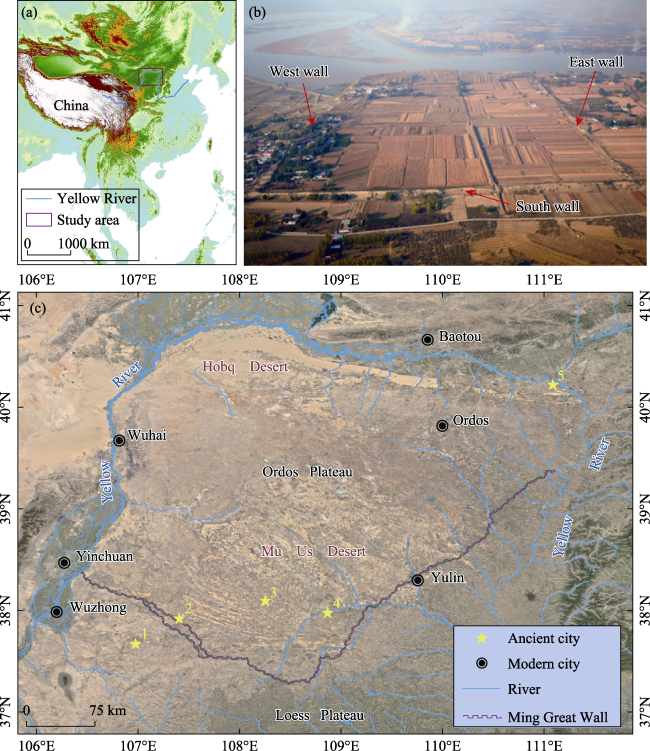
Figure 1 Study area. (a) Location of the Ordos Plateau; (b) Aerial photograph from the southern side of Shi-Er-Lian-Cheng (an ancient city which has been occupied for the longest time in the Ordos Plateau); (c) Detailed satellite image of the Ordos Plateau (Google Earth, 2010). The purple line marks the location of the Ming Great Wall, and the yellow stars represent the following ancient cities: 1, Tiezhuquan; 2, Zhangjiachang; 3, Bayanhurihu; 4, Tongwan city; 5, Shi-Er-Lian-Cheng.
The Ordos Plateau is a relatively independent geomorphic unit in a semi-arid area of China. The special geographical environment and climate change have created a diverse ecological and environmental pattern and bred a unique process of human civilization. Throughout history, nomadic people in this region often competed with farming people. As the Ordos Plateau was in the ecological transition zone, the complex and changeable natural environment, social production mode, and cultural characteristics determined the vulnerability and sensitivity to the environment in this area, which is prone to land degradation and desertification (Hou, 2008).

3 Data and methods

3.1 Data

This paper refers to the records of human settlements in the Atlas of Chinese Cultural Relics (NCHA, 1998, 2003, 2010) and some data from the third national cultural relics census and archaeological excavation briefing (LGIMAR, 2011). In addition, our research team has conducted many field visits to more than 100 human settlements in the Ordos Plateau, including the Mu Us Desert and Hobq Desert, from which we obtained a large amount of first-hand data (Wang et al., 2006a; Huang et al., 2009; He and Wang, 2010). Data from existing human settlements complemented this collection, establishing a database of human settlements from the Neolithic period to the Ming and Qing dynasties in the Ordos Plateau. In the process of statistics of human settlements, in addition to the administrative regions under the jurisdiction of Ordos city, the study area of this paper also includes Dingbian, Jingbian, Hengshan, Yuyang, Shenmu and Fugu in the north of Yulin in Shaanxi province bordering Ordos city, as well as Lingwu city and Yanchi county in Ningxia Hui autonomous region. However, due to the settlement data sources, the human settlements database established in this paper does not include the sites in the late period of the Qing Dynasty.
For this study, settlement distribution maps with a Cartesian coordinate system based on the World Geodetic System 1984 were created using ArcGIS 10.3 software. These maps contain topographic information based on 90 m resolution SRTM DEM data (http:// srtm.csi.cgiar.org), river and lake water systems, and desert distribution data of the Ordos Plateau (http://data.tpdc.ac.cn).

3.2 Method

In data processing, this paper classifies human settlements according to their specific age and eliminates a few sites with unknown ages. According to the political and economic characteristics of different periods in the Ordos Plateau, the periods of human settlements since the Neolithic period were divided into seven stages: early and middle Neolithic (12-5 ka BP); late Neolithic (5 ka BP-2070 BC); Xia, Shang, and Zhou dynasties (2070 BC-256 BC); Qin and Han dynasties (221 BC-AD 220), Wei, Jin, Southern and Northern Dynasties and Sui, and Tang dynasties, referred to as the Wei, Jin, Sui, and Tang dynasties (AD 220-AD 907); Song and Yuan dynasties (AD 907-AD 1368); Ming and Qing dynasties (AD 1368-AD 1912). Due to the short span of the Five Dynasties and Ten Kingdoms regimes (AD 907-AD 979), this paper combines the sites in this period with the Song and Yuan dynasties for statistical processing. Besides, we classified overlapping human settlements into their respective dynasties for statistics. For example, if a particular human settlement lasted from the Yuan to the Ming dynasties, we classify this settlement into two distinct periods for statistical purposes, the Song and Yuan and Ming and Qing dynasties.
Aggregation characteristics are an important index to calculate the spatial distribution of human settlements. On the one hand, it reflects the natural environment’s advantages and disadvantages and the region’s abundance of resources (Li et al., 2015). On the other hand, it reflects the tendency of humans’ selection of sites based on environmental factors (Batty and Longley, 1994). Researchers believe that the spatial evolution of settlements in a geographical unit on the time axis follows the growth principle of fractal geometry (Batty, 2008). Therefore, this paper uses the fractal dimension to discuss the aggregation characteristics of human settlements in the study area.
As a kind of fractal dimension method, box dimension was widely used in practice (Benguigui et al., 2000). The research object is covered with a square grid with side length a, and the side length of the square grid covering the whole object is A. Note that the number of grids overlapping with the research object is N. If the research object is compact, it will be covered with each square grid, where $\text{N}=\frac{{{A}^{2}}}{{{a}^{2}}}$. If the research object is fractal, then $\text{N}={{\left( \frac{A}{a} \right)}^{D}}$, where D is the fractal dimension. The specific calculation formula for the D value is as follows:
$\text{N}={{\left( \frac{A}{a} \right)}^{D}}$
${{\log }_{2}}\left( N \right)={{\log }_{2}}\left( {{\left( \frac{A}{a} \right)}^{D}} \right)$
${{\log }_{2}}\left( N \right)=\text{D}\times {{\log }_{2}}\left( \frac{A}{a} \right)$
${{\log }_{2}}\left( N \right)=\text{D}\times {{\log }_{2}}\left( A \right)-\text{D}\times {{\log }_{2}}\left( a \right)$
${{\log }_{2}}\left( a \right)$=x, ${{\log }_{2}}\left( N \right)$=y, then $\text{y}=-\text{D}\times \text{x}+\text{D}\times {{\log }_{2}}A$, the slope is $-$D. The more uniform the spatial distribution of human archeological sites is in the study area, the greater the absolute slope value and the greater the D value.

4 Results

4.1 Spatiotemporal distribution

Our results indicate that there were 1935 total human settlements in the Ordos Plateau (Figure 2). The number of sites in the early and middle Neolithic periods was 200, and the occurrence frequency of sites was 2.86/100a. Most of the human settlements during this period were middle Neolithic sites, mainly the remains of the Yangshao culture. In the late Neolithic period, agriculture and animal husbandry were highly developed, and the population increased sharply. The number of sites reached 469, and the frequency of sites was 46.9/100a. In terms of spatial distribution, Neolithic sites are concentrated in the eastern and southern riverside areas of the Ordos Plateau, but relatively few human settlements were identified in the rest of the study area (Figures 3a and 3b). During the Xia, Shang, and Zhou dynasties, the number of human settlements decreased to 201, and the frequency of human settlements was 11.53/100a. The scope of human activities demonstrates a shrinking trend (Figure 3c).
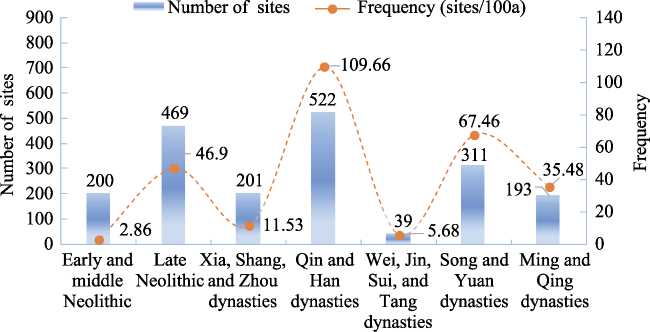
Figure 2 Quantity statistics and occurrence frequency of human settlements in the Ordos Plateau
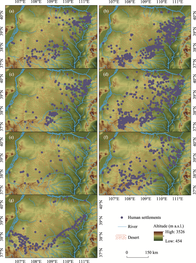
Figure 3 Geographical distribution of human settlements in the Ordos Plateau: (a) Early and middle Neolithic; (b) Late Neolithic; (c) Xia, Shang, and Zhou dynasties; (d) Qin and Han dynasties; (e) Wei, Jin, Sui, and Tang dynasties; (f) Song and Yuan dynasties; (g) Ming and Qing dynasties
During the Qin and Han dynasties, the number of human settlements in Ordos reached 522, and the occurrence frequency of sites was about 109.66/100a. The scope of human activity further spread to the whole Ordos Plateau (Figure 3d). During the Wei, Jin, Sui, and Tang dynasties, only 39 human settlements existed, with a frequency of about 5.68 sites/100a. The sites were distributed discretely in space (Figure 3e). As early as the late Eastern Han Dynasty, the mode of production in this area gradually changed from farming to nomadic culture. In the later Wei and Jin dynasties, this area was occupied by Qiang Hu and Xianbei.
During the Sui and Tang dynasties, the Ordos Plateau became a place for resettling Turkic families. Although there were a certain number of city sites, local people led a nomadic life, so there were very few human settlements left over during this period. By the Song and Yuan dynasties, the frequency of human settlements in the Ordos Plateau reached 67.46/100a, and the number of sites was 311. The sites were concentrated on the river platforms east and south of the Ordos Plateau (Figure 3f). Although the frequency of the sites indicates an upward trend in human settlements, human activities in this period were still at a low level compared with the Qin and Han dynasties, during which the cultural layer of human settlements deeply accumulated. By examining unearthed production tools and living appliances, residents’ way of life at that time was found to be heavily dependent on agriculture and the relatively well-developed handicraft industry. During the Ming and Qing dynasties, there were 193 human settlements with a frequency of 35.48 sites/100a. In the Ming Dynasty, for the needs of military defense, human settlements were concentrated along the Ming Great Wall in a “U” shape (Figure 3g). During the Qing Dynasty, human settlements were basically the same as in the Ming Dynasty. Compared with the Song and Yuan dynasties, the number and frequency of human settlements in the Ming and Qing dynasties showed a downward trend.
To summarize, the number and frequency of human settlements in the Ordos Plateau periodically fluctuated, reaching a peak during the Qin and Han dynasties.

4.2 Aggregation characteristics

This paper standardized the settlements coordinate data when calculating the fractal dimension for different historical stages. Therefore, the value of ‘A’ is fixed, with a value of 1. The range of values for ‘a’ is fixed at 1/1024-1/2, and the range of ‘N’ values is as follows: Early and middle Neolithic (6-128); Late Neolithic (6–363); Xia, Shang, and Zhou dynasties (4-171); Qin and Han dynasties (6–409); Wei, Jin, Sui, and Tang dynasties (6–31); Song and Yuan dynasties (6-173); Ming and Qing dynasties (6-140). As can be seen from Figure 4, ${{\log }_{2}}\left( a \right)$ and ${{\log }_{2}}\left( N \right)$ curves fit well and pass the significance test, indicating that the spatial distribution of human archeological sites in the study area was fractal. The results show that DQin and Han dynasties > DSong and Yuan dynasties > DLate Neolithic period > DEarly and middle Neolithic period > DMing and Qing dynasties > DXia, Shang, and Zhou dynasties > DWei, Jin, Sui, and Tang dynasties. The sites in the Qin and Han dynasties and the Song and Yuan dynasties were in a state of “expansion” in space. The sites were distributed all over the Ordos Plateau, with a “relatively” uniform distribution and a large D value. During the Wei, Jin, Sui, and Tang dynasties, the sites showed a relative “contraction” in space, so the D value was small.
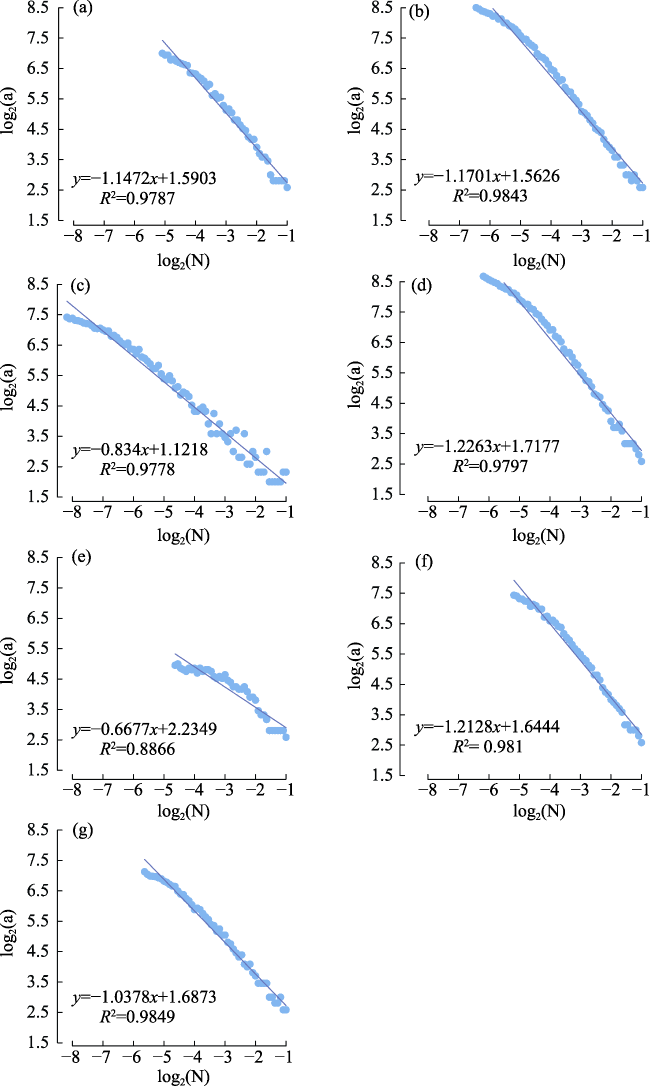
Figure 4 Aggregation fractal dimensions of human settlements in the Ordos Plateau: (a) Early and middle Neolithic; (b) Late Neolithic; (c) Xia, Shang, and Zhou dynasties; (d) Qin and Han dynasties; (e) Wei, Jin, Sui, and Tang dynasties; (f) Song and Yuan dynasties; (g) Ming and Qing dynasties
In general, the aggregation dimension D value of human settlements in each period of the Ordos Plateau was generally small, and the sites were not evenly distributed in all regions of the study area but concentrated in the south and east of the Ordos Plateau (Figure 3). The main reason was that sandy land was widely distributed in the central and western regions of the study area, which is not conducive to the formation of human settlements, especially large-scale settlements or city sites.
The Mu Us Desert and Hobq Desert were distributed in the study area. The existence of a desert will inevitably affect the spatial distribution of human settlements. Results on the number of human settlements in the Ordos desert and non-desert were obtained based on the superposition of the distribution data of human settlements and modern deserts in the Ordos Plateau. The results showed that 32.14% of the sites were distributed in the desert, and 67.86% were in non-desert areas. This spatial distribution indicates that most human settlements in the Ordos Plateau were concentrated in the periphery of the desert area (Figure 3).
The desert is not suitable for human beings to carry out large-scale agricultural production. Numerous sites were distributed in the desert area, suggesting that the region has experienced significant environmental changes over the past thousands of years. Through the field investigation of the ancient cities of Zhangjiachang (Han Dynasty), Tongwan city (Eastern Jin Dynasty), Bayanhurihu (Tang Dynasty), and Tiezhuquan (Ming Dynasty), this paper found that the surface of these ancient city sites has experienced different degrees of desertification (Figure 5). It can be inferred that the large-scale city sites’ ecological environments were relatively good at the beginning of their construction. Affected by climate and environmental changes and unreasonable human activities, the city sites have undergone varying degrees of desertification in later stages (Shi, 1991).
Figure 5 Desertification status of human settlements during different periods in the Ordos Plateau: (a) Zhangjiachang ancient city; (b) Tongwan city; (c) Bayanhurihu ancient city; (d) Tiezhuquan ancient city

4.3 Statistics of site scale

To analyze the quantitative distribution characteristics of different sites, referring to previous studies (Han, 2010; Chen et al., 2018) and comprehensively considering the characteristics of Ordos human settlements, the sites were divided into five categories: ultra-small (s < 5000 m2), small (5000 m2 ≤ s < 20,000 m2), medium (20,000 m2 ≤ s < 100,000 m2), large (100,000 m2 ≤ s < 300,000 m2) and super-large (s ≥ 300,000 m2). The hierarchical statistical results are shown in Figure 6.
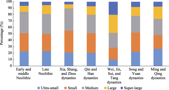
Figure 6 Size statistics of human settlements in the Ordos Plateau
Figure 6 shows that the scale of sites in this area is mainly small and medium-sized sites. The proportion of large and super large sites is low, and the average area of human settlements was 76,900 m2. Although the absolute number of sites in the Wei, Jin, Sui, and Tang dynasties was small, there were large-scale city sites such as Tongwan city, the capital of the great Xia state, and Liuhu State Relics in the Tang Dynasty, so the scale of the sites was mainly medium-sized and large-scale sites. In addition, although the absolute number of sites in different periods differed, the proportion of super small sites and super large sites in each period is roughly the same.

5 Discussion

5.1 Climate change impacts human settlement distribution

Climate is the most critical and active factor affecting human society (Butzer, 2012; Carleton and Hsiang, 2016). Economies based on agriculture and animal husbandry were inevitably affected by climate change, which in turn affected human settlements (Polyak and Asmerom, 2001; Pederson et al., 2014; Pei and Zhang, 2014). The impacts of climate change on the spatial distribution of human settlements were indirectly realized through changing living environments (Zhang et al., 2011; Feng et al., 2019). The Ordos Plateau was located at the margin of monsoons and was sensitive to climate change. By analyzing the Quaternary strata of the Ordos Plateau, researchers found that the sedimentary environment in this area has a long-term and complex evolution process, showing multiple changes in climate and environment (Sun et al., 1998; Li et al., 2000; Lu et al., 2005; Mason et al., 2009; Xu et al., 2015; Liu et al., 2017; Xu et al., 2020). Through the study of the Salawusu River stratum, researchers believed that in the late Pleistocene, the climate of the Ordos Plateau tended to be dry, cold, and windy (Dong et al., 1983). Research in the Baahar Nuur Lake showed that this situation lasted until the early Holocene and the climate of the Ordos Plateau was still cold and dry before about 7.65 ka BP (Guo et al., 2007). In the middle of the Holocene, the vegetation was luxuriant with the increase in temperature and precipitation, and many animals moved into this area again. Xu (2020) found that the area of active sand dunes in northern China’s sandy land was the least around 6,000 years ago. The pollen study on the Mu Us Desert showed that the landscape developed from grassland to sparse forest grassland in the early to middle Holocene (Chen et al., 1993). This suitable climate led to the further expansion of human activities in the late Neolithic period, and human settlements increased significantly during this period (Figures 2 and 3).
Chu Kochen (1973) inferred from the phenological data of plant growth that the climate was warm during the Qin and Western Han dynasties and tended to be cold in the Eastern Han Dynasty. Combined with the influence of the policy of “immigration and border consolidation,” the Ordos Plateau ushered in a period of large-scale agricultural development, which once made the area a place of “fertile fields and thousands of miles, grain accumulates in large quantities” (historical records of the Eastern Han Dynasty, from ‘Hou Han Shu,’ written by Fan Ye). Due to the warming climate and abundant vegetation (Figure 7), a large number of people moved into the Ordos Plateau, the scope of human activities further expanded, and the site distribution spread out to the Ordos Plateau (Figures 2 and 3). During this period, there were 37 super large sites with an area of more than 300,000 m2 and 68 large city sites with an area of 100,000-300,000 m2. The emergence of large city sites also reflected that human activities were in the peak stage in this period. During the Wei, Jin, Sui, and Tang dynasties, sandstorms on the Ordos Plateau were more frequent (Hou et al., 2001; Meng et al., 2009), and the number of human settlements was the lowest in this historical period. Although Helianbobo built the only ancient state capital, Tongwan city (Figures 1c and 5b), on the bank of the Wuding River during this period, the pollen analysis results showed that the climate was still relatively cold and dry in the Wei, Jin, Southern, and Northern dynasties, with a relatively short humid period from 1.6-1.5 ka BP (Hou et al., 2001). During the Sui and Tang dynasties, the climate became warmer, but it was still dry. The pollen data of Gouchi showed that the climate tended to be arid from AD 940 to AD 1260 (Meng et al., 2009).
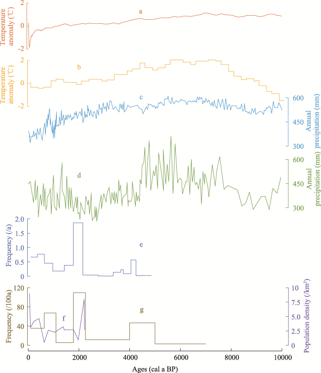
Figure 7 Comparison between the occurrence frequencies of human settlements and Holocene climate change. (a) The annual mean temperature anomaly of 30°N-90°N in the Northern Hemisphere (Marcott et al., 2013). (b) The annual mean temperature anomaly of China (Wang and Gong, 2000). (c) Annual precipitation reconstruction of Gonghai Lake (Chen et al., 2015a). (d) Annual precipitation reconstruction of Daihai Lake (Xiao et al., 2004). (e) The occurrence frequencies of human settlements in the Hexi Corridor (Yang et al., 2020). (f) Historical population density in the Ordos Plateau (He and Wang, 2010). (g) This paper.
In the Song and Yuan dynasties, the climate was relatively warm, and the way of farming and industry allowed humans to settle more permanently (Yang, 1999). During this period, the number of human settlements increased relatively (Figures 2 and 3). From the perspective of spatial distribution, water resources were still key factors for site selection, as platforms are visibly agglomerated on both sides of the river. Relevant studies showed that the rapid undercutting of the Wuding River formed a suitable environment in the upper reaches of the Wuding River during the Song and Yuan dynasties (Hu et al., 2011). The emergence of human settlements, such as the ancient city of Sanchahe, reflected the prosperity of human activities in this region during this period. Affected by the cutting depth of the river, the environmental degradation in the upper reaches of the Wuding River was evident in the Ming and Qing dynasties, and the number of human settlements decreased sharply (Wen et al., 2021; Wang et al., 2022).
The Little Ice Age generally refers to the relatively cold climate period from 1550 AD to 1850 AD, coinciding with China’s Ming and Qing dynasties (Wang and Gong, 2000). Pollen records of Gouchi showed that the vegetation in the study area during this period was a grassland dominated by Artemisia (Meng et al., 2009). In the Ming Dynasty, the Great Wall was built in the Ordos Plateau to meet the needs of high-level military defense, and the human settlements showed a “U” shaped strip (Figure 3). According to the historical records from Yan Sui Zhen Zhi, telling the history of the city of Yan Sui in the southern Ordos Plateau. Yu Zijun’s (governor of Yulin city) original intention when building the Ming Great Wall was not just to guard the frontier. Since nomadic people pursued areas with water and grass for a living, he intended that all places with luxuriant vegetation should be enclosed within the Great Wall so that the nomadic people could not graze. Furthermore, the places where the sand dunes were active were to be excluded from the Great Wall to make it unhabitable for the nomadic people. Combining modern data with historical documents, we know that the area north of the Ming Great Wall was mostly sandy land, which was unsuitable for farming production and permanent settlement. The number of sites in the Ming and Qing dynasties was 193, and the frequency of sites was 35.48/100a (Figure 2). From the spatial distribution characteristics of human settlements, the number of human settlements in the north of the Great Wall was minimal, reflecting limited land use and possible environmental deterioration in the Ordos Plateau during the Ming and Qing dynasties.
The corresponding relationship between climate change and socio-economic fluctuations in China’s history is generally believed to be roughly summarized as “cold restraining and warm rising.” That is, the climate in the warm period was generally favorable (Ge, 2011; Fang et al., 2015). Historically, the periods of economic development, social stability, population increase, and territory expansion often occur in the warm period on a hundred-year scale, while the opposite occurs in the cold period (Zhang et al., 2007; Pei and Zhang, 2014). By examining the relationship between the temporal and spatial distribution of human settlements and the environmental changes from the Neolithic to the Ming and Qing dynasties in the Ordos Plateau, we found that climate change has a profound impact on human activities in this area and on the temporal and spatial distribution of human settlements. By comparing the frequency of human settlements with the Holocene climate change data (Figures 2 and 7), the research showed that the Holocene climate suitable period created conditions for the prosperity of Neolithic farming culture in the Ordos Plateau. Until the warm period of the Qin and Han dynasties, the relatively warm and humid climate also supported the development of the Ordos Plateau. When the climate tended to be cold and dry, the occurrence frequency of sites was relatively low, and the distribution of sites was discrete. After the Qin and Han dynasties, although the climate fluctuated, it was generally arid, and the frequency of human settlements was low.

5.2 Livelihood patterns, policy, and wars impacts human settlement distribution

Different livelihood patterns lead to different ways of land use, which can affect the spatial distribution of human settlements (Dong et al. 2013a, 2013b; Bevan et al., 2017). In the Paleolithic period, people relied on gathering and hunting for food. However, in areas with fragile and sensitive environments, climate fluctuations reduced animal and plant resources, which made it difficult for people to obtain food through gathering and hunting (Chang, 1960). During this period, humans were compelled to change from original food gatherers to food producers to ensure their survival and reproduction. Therefore, primitive agriculture came into existence (Han, 2010). Compared with hunting and gathering, farming can feed more people and allow humans to cope better with food shortages caused by climate change or other factors. Simultaneously, the farming mode of production also forced humankind to settle permanently. Therefore, the frequency of human settlements in the farming stage is relatively high.
Early animal husbandry was accompanied by primitive agriculture, but it did not have the characteristics of migration; it belonged to stocking animal husbandry. Studies have shown that at 3.5 ka-3 ka BP, the climate of Eurasia turns into a cold period, which leads to the separation of animal husbandry from primitive agriculture in the agro-pastoral ecotone most sensitive to climate change and leads to the development of a nomadic mode of living in grassland environments (Sauer, 1952; Han, 2003). Living by water and grass is a nomadic civilization’s fundamental way of life; therefore, migration also became the primary feature of nomadic life. Compared with the farming mode, the nomadic population was relatively small, and the population mobility was strong, which made the frequency of human settlements in the nomadic stage relatively low (Nicola, 2002). The intensive farming civilization stresses the settled life of gathering ethnic groups, while the nomadic civilization grazes with water and grass and lives in impermanent places. Therefore, farming civilizations often pay attention to the construction of city sites, and human settlements show a gathering trend. In contrast, there exist few nomadic civilizations and cities, and the spatial distribution of nomadic sites is relatively scattered. In this paper, residents in the Ordos Plateau mainly lived by farming during the Qin and Han dynasties. There were 522 settlement sites and city sites, and the frequency of sites was about 109.66/100a. Local people mostly led a nomadic lifestyle during the Wei, Jin, Sui, and Tang dynasties. Nomadic people “are good at riding and shooting, graze with water and grass, live in impermanent places, and take yurt as their house” (historical records from ‘Shi Ji’). Therefore, the number of sites decreased sharply to 39, and their frequency was about 5.68/100a (Figure 2). During this period, large-scale city sites such as Tongwan city and Liuhu State Relics existed. Tongwan city is a unique ancient capital city in the Ordos Plateau and one of the most majestic and sturdy capitals built by early nomadic people in northern China. Liuhu State Relic in the Tang Dynasty resettled the Turkic surrendered tribes, so the scale of the human settlements during the Wei, Jin, Sui, and Tang dynasties was mainly medium-sized and large-scale sites.
In addition to the mode of production and employment, policy also plays a critical role in social development. It directly impacts the temporal and spatial distribution of human settlements by affecting the number of people and population migration. During the Qin Dynasty, the first emperor sent Meng Tian to attack the Huns in the north, set up counties in the Ordos Plateau, built the Great Wall, and built the historical “Qin straight road.” The straight road starts from Jiuyuan (now Baotou city, Inner Mongolia) in the north and Yunyang (now Chunhua county, Shaanxi) near Xianyang in the south, with a total length of more than 700 km. The road is wide and flat, which can accommodate the rapid passage of large groups of people and horses. In the second year of Yuanshuo of the Western Han Dynasty (127 B.C.), the Central government set up six counties in today’s Ordos Plateau, namely Xihe, Shuofang, Yunzhong, Beidi, Wuyuan, and Shangjun. Nearly one million people migrated from the mainland and settled in the Ordos Plateau to engage in agricultural production (historical records from ‘Shi Ji,’ written by Si Maqian, in a book covering more than 3000 years of history from the legendary Huang Di era to the Western Han Dynasty, 101 BC). At that time, people also adopted the most advanced agricultural tools and farming methods, such as cattle farming, iron plow, and the substitution method, and carried out large-scale land development in this area. The large-scale population migration increased the population density at that time (Figure 8c), and the frequency of human settlements also peaked. In addition, the frequency of human settlements increased during the Song and Yuan Dynasties due to the war between farmers and nomads (Figures 2 and 8).
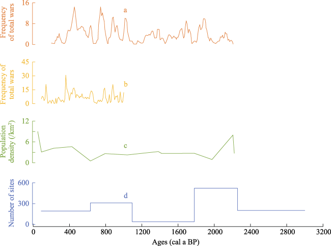
Figure 8 Human settlements and war frequency: (a) Wars between farming and nomadic groups from Western Han Dynasty to Qing Dynasty in northern China (Liu et al., 2016); (b) Wars in northern China over the last millennium (Zhang et al., 2006); (c) Historical population density in the Ordos Plateau (He and Wang, 2010); (d) This paper.
The confrontation between the central government and the nomadic nationalities (Figure 8), such as the Tatar and Wala changed the spatial distribution pattern of human settlements in the Ordos Plateau in the early Ming Dynasty (Man et al., 2000). The construction of the Great Wall blocked the communication between the farmers and the nomads, so the human settlements were concentrated along the Ming Great Wall in a “U” shaped strip (Figure 3g). The north of the Great Wall witnessed mainly nomadic activities. In addition, the environment was deteriorating, and desertification was serious at this stage, so the number of human settlements was minimal.

6 Conclusions

The following conclusions were drawn:
(1) The frequency of human settlements in the Ordos Plateau showed periodic fluctuations. The spatial distribution of sites has fractal characteristics, and the aggregation dimension D was generally small. Deserts impacted the spatial distribution of human settlements, concentrated in the south and east of the Ordos Plateau. The scale of the sites was mainly small and medium-sized, a few sites were large.
(2) Settlements resulted from the comprehensive action of natural and human factors. Their temporal and spatial distribution responds to the natural environment changes. How local people lived and worked significantly affected the frequency of human settlements. In addition, the central government’s policies, and the war between farming and nomadic also impacted human settlements’ temporal and spatial distribution.

Acknowledgments

The authors wish to sincerely thank Prof. Yinzhou Huang and Dr. Kai Ning for their invaluable advice.
[1]
Batty M, 2008. The size, scale, and shape of cities. Science, 319(5864): 769-771.

DOI PMID

[2]
Batty M, Longley P, 1994. Fractal Cities:A Geometry of Form and Function. London: Academic Press.

[3]
Benguigui L, Czamanski D, Marinov M et al., 2000. When and where is a city fractal? Environment and Planning B: Planning and Design, 27: 507-519.

[4]
Bevan A, Colledge S, Fuller D et al., 2017. Holocene fluctuations in human population demonstrate repeated links to food production and climate. Proceedings of the National Academy of Sciences of the United States of America, 114(49): E10524-E10531.

[5]
Bubenzer O, Riemer H, 2007. Holocene climatic change and human settlement between the central Sahara and the Nile Valley: Archaeological and geomorphological results. Geoarchaeology, 22(6): 607-620.

DOI

[6]
Butzer K W, 2012. Collapse, environment, and society. Proceedings of the National Academy of Sciences of the United States of America, 109(10): 3632-3639.

DOI PMID

[7]
Carleton T A, Hsiang S M, 2016. Social and economic impacts of climate. Science, 353(6304): 9837-9852.

[8]
Chang K C, 1960. Prehistoric settlements in China: A study in archaeological method and theory[D]. Boston: Harvard University.

[9]
Chen F, Xu Q, Chen J et al., 2015a. East Asian summer monsoon precipitation variability since the last deglaciation. Scientific Reports, 5: doi: 10.1038/srep11186.

[10]
Chen F H, Dong G H, Zhang D J et al., 2015b. Agriculture facilitated permanent human occupation of the Tibetan Plateau after 3600 B. P. Science, 347(6219): 248-250.

DOI

[11]
Chen R, Li F Q, Wang T Y et al., 2018. The size distribution of Neolithic sites in the middle reaches of the Yangtze River. Acta Geographica Sinica, 73(3): 474-486. (in Chinese)

DOI

[12]
Chen W N, Gao S Y, Shao Y J et al., 1993. The sporo-pollen combination and climatic changes of Mu Us Desert during Holocene. Journal of Chinese Historical Geography, (1): 39-54. (in Chinese)

[13]
Chu K, 1973. A preliminary study on the climatic changes since the last 5000 years in China. Scientia Sinica, (2): 15-38.

[14]
Cui J X, Chang H, 2013. The possible climate impact on the collapse of an ancient urban city in Mu Us Desert, China. Regional Environmental Change, 13(2): 353-364.

DOI

[15]
Cui J X, Chang H, Cheng K Y et al., 2017. Climate change, desertification, and societal responses along the Mu Us Desert margin during the Ming Dynasty. Weather, Climate, and Society, 9(1): 81-94.

[16]
Cui Y F, Liu Y J, Ma M M, 2018. Spatiotemporal evolution of prehistoric Neolithic-Bronze Age settlements and influencing factors in the Guanting Basin, northeast Tibetan Plateau. Science China Earth Sciences, 61(2): 149-162.

DOI

[17]
deMenocal P B, 2001. Cultural responses to climate change during the Late Holocene. Science, 292: 667-673.

PMID

[18]
Deng H, Shu S G, Song Y Q et al., 2007. Distribution of sand dunes and sand shifts along the southern fringe of the Mu Us Desert since the Ming Dynasty. Chinese Science Bulletin, 52(22): 3128-3138. (in Chinese)

DOI

[19]
Dong G H, Jia X, Elston R et al., 2013a. Spatial and temporal variety of prehistoric human settlement and its influencing factors in the upper Yellow River valley, Qinghai province, China. Journal of Archaeological Science, 40(5): 2538-2546.

DOI

[20]
Dong G H, Wang L, Cui Y F et al., 2013b. The spatiotemporal pattern of the Majiayao cultural evolution and its relation to climate change and variety of subsistence strategy during late Neolithic period in Gansu and Qinghai provinces, northwest China. Quaternary International, 316: 155-161.

DOI

[21]
Dong G H, Wang L B, Zhang D D et al., 2020. Climate-driven desertification triggered the end of the Ancient Silk Road. Climate of the Past, 17: 1395-1407.

DOI

[22]
Dong G R, Li B S, Gao S Y, 1983. The case study of the vicissitude of the Mu Us Sandy Land since the late pleistocene according to the Salawusu River strata. Journal of Desert Research, 3(2): 9-14. (in Chinese)

[23]
Fang H, Feinman G M, Nicholas L M, 2015. Imperial expansion, public investment, and the long path of history: China’s initial political unification and its aftermath. Proceedings of the National Academy of Sciences of the United States of America, 112(30): 9224-9229.

DOI PMID

[24]
Fang X Q, Su Y, Yin J et al., 2015. Transmission of climate change impacts from temperature change to grain harvests, famines and peasant uprisings in the historical China. Science China: Earth Sciences, 58(8): 1427-1439.

DOI

[25]
Feng Q, Yang L S, Deo R C et al., 2019. Domino effect of climate change over two millennia in ancient China’s Hexi Corridor. Nature Sustainability, 2: 957-961.

DOI

[26]
Ge Q S, 2011. Climate Change Through Every Chinese Dynasty. Beijing: Science Press. (in Chinese)

[27]
Ge Q S, Zhu H Y, 2021. Changes of the physical and human geographical environment in China during the past 2000 years. Acta Geographica Sinica, 76(1): 3-14. (in Chinese)

DOI

[28]
Guo L L, Feng Z D, Li X Q et al., 2007. Holocene climatic and environmental changes recorded in Baahar Nuur Lake core in the Ordos Plateau, Inner Mongolia of China. Science Bulletin, 52(5): 584-590. (in Chinese)

[29]
Han M L, 2003. The relationship between environmental changes and naissance of the nomadic life in northern China. Geographical Research, 22(1): 89-95. (in Chinese)

DOI

[30]
Han M L, 2010. A study on settlements and environment of prehistoric times in the west Liaohe River valley. Acta Archaeologica Sinica, (1): 1-20. (in Chinese)

[31]
He T H, Wang N A, 2010. The Environment Change of Mu Us Desert in Historical Period. Beijing: People’s Publishing House. (in Chinese)

[32]
Hosner D, Wagner M, Tarasov P E et al., 2016. Spatiotemporal distribution patterns of archaeological sites in China during the Neolithic and Bronze Age: An overview. The Holocene, 26(10): 1576-1593.

DOI

[33]
Hou Y J, 2008. Study on the Historical Geography of Ordos and Its Adjacent Areas>. Xi’an: Sanqin Publishing House. (in Chinese)

[34]
Hou Y J, Zhou J, Wang Y X, 2001. The natural and hmane landscape in the Ordos Plateau during the Bei Wei Dynasty (AD 386-534). Journal of Desert Research, 21(2): 188-194. (in Chinese)

[35]
Hsu K J, 1998. Sun, climate, hunger, and mass migration. Science in China Series D: Earth Sciences, 41(5): 449-472.

DOI

[36]
Hu K, Mo D W, Wang H et al., 2011. Environmental changes and human activities on both sides of Sarah Wusu River, in Song (Xixia) and Yuan dynasty. Acta Scientiarum Naturalium Universitatis Pekinensis, 47(3): 466-474. (in Chinese)

[37]
Huang Y Z, Wang N A, Fu J et al., 2018. Distribution of archaeological sites on the Ordos Plateau over Qin and Han dynasties and its environmental significance. Geographical Research, 37(11): 2165-2176. (in Chinese)

DOI

[38]
Huang Y Z, Wang N A, He T H et al., 2009. Historical desertification of the Mu Us Desert, northern China: A multidisciplinary study. Geomorphology, 110(3): 108-117.

DOI

[39]
Leading Group of the Inner Mongolia Autonomous Region for the Third National Cultural Relics Survey LGIMAR, 2011. New Discoveries of the Third National Cultural Relics Survey in the Inner Mongolia Autonomous Region. Beijing: Cultural Relics Press. (in Chinese)

[40]
Li B S, David Z D, Jin H L et al., 2000. Paleo-monsoon activities of Mu Us Desert, China since 150 ka B. P.: A study of the stratigraphic sequences of the Milanggouwan Section, Salawusu River area. Palaeogeography, Palaeoclimatology, Palaeoecology, 162(1): 1-16.

DOI

[41]
Li F, Wu L, Zhu C et al., 2013. Spatial-temporal distribution and geographic context of Neolithic cultural sites in the Hanjiang River Basin, Southern Shaanxi, China. Journal of Archaeological Science, 40: 3141-3152.

DOI

[42]
Li K F, Zhu C, Jiang F Q et al., 2014. Archaeological sites distribution and its physical environmental settings between ca 260-2.2 ka BP in Guizhou, Southwest China. Journal of Geographical Sciences, 24(3): 526-538.

DOI

[43]
Li L, Wu L, Zhu C et al., 2011. Relationship between archaeological sites distribution and environment from 1.15 Ma BP to 278 BC in Hubei province. Journal of Geographical Sciences, 21(5): 909-925.

DOI

[44]
Li Y, Lu P, Mao L J et al., 2021. Mapping spatiotemporal variations of Neolithic and Bronze Age settlements in the Gansu-Qinghai region, China: Scale grade, chronological development, and social organization. Journal of Archaeological Science, 129: doi: 10.1016/j.jas.2021.105357.

[45]
Li Z X, Zhu C, Yuan S Y et al., 2015. Geographical distribution, diffusion and subsistence variation of prehistoric cultures in Nanyang Basin, Henan province. Acta Geographica Sinica, 70(1): 143-156. (in Chinese)

DOI

[46]
Liu L, Su Y, Fang X Q, 2016. Wars between farming and nomadic groups from Western Han Dynasty to Qing Dynasty in north China and relationship with temperature change. Journal of Beijing Normal University (Natural Science), 52(4): 450-457. (in Chinese)

[47]
Liu X K, Lu R J, Z Q et al., 2017. Magnetic susceptibility of surface soils in the Mu Us Desert and its environmental significance. Aeolian Research, 25: 127-134.

DOI

[48]
Lu H Y, Miao X D, Zhou Y L et al., 2005. Late Quaternary aeolian activity in the Mu Us and Otindag dune fields (north China) and lagged response to insolation forcing. Geophysical Research Letters, 32(21): L21716.

[49]
Man Z M, Ge Q S, Zhang P Y, 2000. Case studies on the impact of climatic changes on the farming-pastoral transitional zone in historical period. Geographical Research, 19(2): 141-147. (in Chinese)

[50]
Marcott S A, Shakun J D, Clark P U et al., 2013. A reconstruction of regional and global temperature for the past 11,300 years. Science, 339(6124): 1198-1201.

DOI PMID

[51]
Mason J A, Lu H Y, Zhou Y L et al., 2009. Dune mobility and aridity at the desert margin of northern China at a time of peak monsoon strength. Geology, 37(10): 947-950.

DOI

[52]
Medina-Elizalde M, Rohling E J, 2012. Collapse of classic Maya civilization related to modest reduction in precipitation. Science, 335(6071): 956-959.

DOI PMID

[53]
Meng H W, Ma Y Z, Wang W et al., 2009. Vegetation and environment change based on high resolution pollen records of the last 2400 years in Dingbian, Shaanxi province, China. Quaternary Sciences, 29(5): 931-942. (in Chinese)

[54]
National Cultural Heritage Administration NCHA, 1998. Atlas of Chinese Cultural Relics:Fascicule of Shaanxi Province. Xi’an: Xi’an Cartographic Press. (in Chinese)

[55]
National Cultural Heritage Administration NCHA, 2003. Atlas of Chinese Cultural Relics:Fascicule of the Inner Mongolia Autonomous Region. Xi’an: Xi’an Cartographic Press. (in Chinese)

[56]
National Cultural Heritage Administration NCHA, 2010. Atlas of Chinese Cultural Relics:Fascicule of the Ningxia Hui Autonomous Region. Beijing: Cultural Relics Press. (in Chinese)

[57]
Nicola D C, 2002. Ancient China and Its Enemies:The Rise of Nomadic Power in East Asian History. Cambridge: Cambridge University Press.

[58]
Pederson N, Hessl A E, Baatarbileg N et al., 2014. Pluvials, droughts, the Mongol Empire, and modern Mongolia. Proceedings of the National Academy of Sciences of the United States of America, 111(12): 4375-4379.

DOI PMID

[59]
Pei Q, Lee H F, Zhang D D et al., 2019. Climate change, state capacity and nomad-agriculturalist conflicts in Chinese history. Quaternary Internationnal, 508: 36-42.

[60]
Pei Q, Zhang D D, 2014. Long-term relationship between climate change and nomadic migration in historical China. Ecology and Society, 19(2): 68.

[61]
Peterson L, Haug G, 2005. Climate and the collapse of Maya civilization. American Scientist, 93(4): 322.

DOI

[62]
Polyak V J, Asmerom Y, 2001. Late Holocene climate and cultural changes in the southwestern United States. Science, 294: 148-151.

PMID

[63]
Ruan H B, Wang N A, Niu Z M et al., 2016. Spatial pattern of ancient city sites and its driving forces in Mu Us Sandy Land during Han Dynasty. Acta Geographica Sinica, 71(5): 873-882. (in Chinese)

DOI

[64]
Sauer C O, 1952. Agricultural Origins and Dispersals. New York: American Geographical Society.

[65]
Shi P J, 1991. Theory and practise of research into geography environment changes:Research into geographical environment change during Late Quaternary Period in the Ordos Region of North China. Beijing: Science Press. (in Chinese)

[66]
Sun J M, Yin G M, Ding Z L et al., 1998. Thermoluminescence chronology of sand profiles in the Mu Us Desert, China. Palaeogeography, Palaeoclimatology, Palaeoecology, 144: 225-233.

DOI

[67]
Teilhard D C, Licent F, 1924. On the Discovery of a Palaeolithic Industry in northern China. Bulletin of the Geological Society of China, 3(1): 45-50.

DOI

[68]
Wagner M, Tarasov P, Hosner D et al., 2013. Mapping of the spatial and temporal distribution of archaeological sites of northern China during the Neolithic and Bronze Age. Quaternary International, 290: 344-357.

[69]
Wang N A, He T H, Huang Y Z et al., 2006a. Discovery of Liuhu State Relic and its significance of environmental indication. Journal of Chinese Historical Geography, 21(3): 36-46. (in Chinese)

[70]
Wang N A, Huang Y Z, He T H et al., 2006b. The environmental significance of tamping sandy layer in Ancient City Ramparts on Erdos Plateau. Acta Geographica Sinica, 61(9): 937-945. (in Chinese)

[71]
Wang S W, Gong D Y, 2000. Temperature in China during several characteristic periods of Holocene. Progress in Natural Science, 10(4): 325-332. (in Chinese)

[72]
Wang S Y, Dong J B, 2001. The rise and fall of Tongwan city with the environmental change of Mu Us Sandy Land. Geographical Research, 20(3): 347-353. (in Chinese)

DOI

[73]
Wang W, Li B S, Wen X H et al., 2022. Abandonment of ancient cities near the Salawusu River valley, China, triggered by stream capture. Communications Earth & Environment, 3(326): doi: 10.1038/s43247-022-00657-6

[74]
Wei Z D, Fang X Q, Su Y, 2014. Climate change and fiscal balance in China over the past two millennia. Holocene, 24: 1771-1784.

DOI

[75]
Wen P H, Wang N A, Wang Y X et al., 2021. Fluvial incision caused irreversible environmental degradation of ancient city in the Mu Us Desert, China. Quaternary Research, 99: 1-13.

DOI

[76]
Wu L, Sun X, Sun W et al., 2020. Evolution of Neolithic site distribution (9.0-4.0 ka BP) in Anhui, East China. Journal of Geographical Sciences, 30(9): 1451-1466.

DOI

[77]
Wu Q L, Zhao Z J, Liu L et al., 2016. Outburst flood at 1920 BCE supports historicity of China’s Great Flood and the Xia dynasty. Science, 353(6299): 579-582.

DOI

[78]
Xia Z K, Deng H, Wu H L, 2000. Geomorphologic background of the prehistoric cultural evolution in the Xar Moron River Basin, Inner Mongolia. Acta Geographica Sinica, 55(3): 329-336. (in Chinese)

DOI

[79]
Xiao J L, Xu Q H, Nakamura T et al., 2004. Holocene vegetation variation in the Daihai Lake region of north-central China: A direct indication of the Asian monsoon climatic history. Quaternary Science Reviews, 23(14/15): 1669-1679.

DOI

[80]
Xu J J, Jia Y L, Ma C M et al., 2016. Geographic distribution of archaeological sites and their response to climate and environmental change between 10.0-2.8 ka BP in the Poyang Lake Basin, China. Journal of Geographical Sciences, 26(5): 603-618.

DOI

[81]
Xu Z W, Lu H Y, Yi S W et al., 2015. Climate-driven changes to dune activity during the Last Glacial Maximum and deglaciation in the Mu Us dune field, north-central China. Earth & Planetary Science Letters, 427: 149-159.

[82]
Xu Z W, Mason J A, Xu C et al., 2020. Critical transitions in Chinese dunes during the past 12,000 years. Science Advances, 6(9): eaay8020.

DOI

[83]
Yang L, Shi Z, Zhang S et al., 2020. Climate change, geopolitics, and human settlements in the Hexi Corridor over the last 5,000 years. Acta Geologica Sinica (English Edition), 94(3): 612-623.

DOI

[84]
Yang X P, Scuderi L A, Wang X L et al., 2015. Groundwater sapping as the cause of irreversible desertification of Hunshandake Sandy Lands, Inner Mongolia, northern China. Proceedings of the National Academy of Sciences of the United States of America, 112(3): 702-706.

DOI PMID

[85]
Yang Z R, 1999. A Comprehensive Study of Holocene Environmental Evolution in the Agro-pastoral Ecotone in Northern China. Beijing: China Ocean Press. (in Chinese)

[86]
Zhang D, Deng H, 2019. Historical human activities accelerated climate-driven desertification in China’s Mu Us Desert. Science of The Total Environment, 708(15): doi: 10.1016/j.scitotenv.2019.134771.

[87]
Zhang D D, Brecke P, Lee H F et al., 2007. Global climate change, war, and population decline in recent human history. Proceedings of the National Academy of Sciences of the United States of America, 104(49): 19214-19219.

DOI PMID

[88]
Zhang D D, Jim C Y, Lin C S et al., 2006. Climatic change, wars and dynastic cycles in China over the last millennium. Climatic Change, 76(3/4): 459-477.

DOI

[89]
Zhang D D, Lee H F, Wang C et al., 2011. The causality analysis of climate change and large-scale human crisis. Proceedings of the National Academy of Sciences of the United States of America, 108(42): 17296-17301.

DOI PMID

[90]
Zhang H Q, Zhao W M, Liu B, 2007. Mathematical modelling of the relationship between neolithic sites and the rivers in Xi’an (Shaanxi province, China). Archaeometry, 49(4): 765-773.

DOI

[91]
Zhang S D, Zhang D D, Pei Q, 2021. Spatiotemporal shifts of population and war under climate change in imperial China. Climatic Change, 165: 11: doi: 10.1007/s10584-021-03042-y.

[92]
Zhao C S P, Mo D W, 2020. Holocene hydro-environmental evolution and its impacts on human occupation in Jianghan-Dongting Basin, middle reaches of the Yangtze River, China. Journal of Geographical Sciences, 30(3): 423-438.

DOI

[93]
Zong Y, Innes J, Wang Z et al., 2012. Environmental change and Neolithic settlement movement in the lower Yangtze wetlands of China. The Holocene, 22(6): 659-673.

DOI

Outlines

/