Research Articles

Evolution characteristics and driving factors of rural regional functions in the farming-pastoral ecotone of northern China

  • CUI Xiao , 1, 2 ,
  • DENG Xiyue 3 ,
  • WANG Yongsheng , 1, 2, *
Expand
  • 1. Key Laboratory of Regional Sustainable Development Modeling, Institute of Geographic Sciences and Natural Resources Research, CAS, Beijing 100101, China
  • 2. College of Resources and Environment, University of Chinese Academy of Sciences, Beijing 100049, China
  • 3. College of Tourism and Urban-Rural Planning, Chengdu University of Technology, Chengdu 610059, China
*Wang Yongsheng (1985−), PhD and Associate Professor, specialized in rural resource utilization and environmental effect. E-mail:

Cui Xiao (1999−), specialized in agricultural resource utilization. E-mail:

Received date: 2022-11-28

  Accepted date: 2023-05-10

  Online published: 2023-10-08

Supported by

National Natural Science Foundation of China(42271275)

Key Program of National Natural Science Foundation of China(41931293)

Abstract

Rural decline is a global issue accompanied by the regional imbalanced development and dysfunction in rural areas. Coordinated interaction among production, living, and ecological functions is essential for the sustainability of rural regional systems. Based on the framework of “element-structure-function”, an indicator system was constructed to explore the evolution characteristics and driving factors of rural regional functions in the farming-pastoral ecotone of northern China (FPENC) using the models of entropy-based TOPSIS (Technique for Order of Preference by Similarity to Ideal Solution), revised vertical and horizontal comparison, and GeoDetector. The results indicated a gradual synergy of rural production, living, and ecological functions during the period 2000-2020. Improvements were observed in production and living functions, and higher ecological function was found in Hebei, Inner Mongolia, Liaoning, and Shaanxi. However, conflicts between ecological function and production and living functions were evident in Shanxi, Gansu, and Ningxia. The spatial structure played a dominant role in determining rural production, living, and ecological functions, with ratios of 38%, 56%, and 84%, respectively. Land and industry emerged as the main driving factors influencing the evolution of rural regional functions. Notably, combined interactions of rural permanent population and primary industry output (0.73), grassland area and tertiary industry output (0.58), and forest area and tertiary industry output (0.72) were responsible for the changes observed in rural production, living, and ecological functions, respectively. The findings suggest that achieving coordinated development of rural regional functions can be accomplished by establishing differentiated rural sustainable development strategies that consider the coupling of population, land, and industry in FPENC.

Cite this article

CUI Xiao , DENG Xiyue , WANG Yongsheng . Evolution characteristics and driving factors of rural regional functions in the farming-pastoral ecotone of northern China[J]. Journal of Geographical Sciences, 2023 , 33(10) : 1989 -2010 . DOI: 10.1007/s11442-023-2162-2

1 Introduction

The rural regional system has a specific structure and function, composed of diverse and interactive elements (Long et al., 2016; Liu et al., 2020b). These functions are typically categorized into three fundamental aspects: production, living, and ecological functions (Yang et al., 2020a). The production function provides agricultural, industrial, and service products necessary for human survival and development. The living function offers human living spaces and facilities for consumption, leisure, and entertainment, and the ecological function provides natural resources and ecological services (Zhou et al., 2017). Synergies and trade-offs among these functions are common during the process of rural transformation and development (Yang et al., 2020a; Zou et al., 2021). Coordinated development of these functions is essential for rural revitalization, as an imbalanced development can lead to rural decline. Therefore, identifying the spatial and temporal evolution of rural regional functions is an important task for optimizing regional human-land systems and promoting rural sustainable development.
The long-term priority given to urban development has resulted in a one-way flow of rural population, land, and capital to urban areas (Tu and Long, 2017). This has caused an insufficient allocation of rural elements and significant incoordination of rural regional functions, leading to serious “rural diseases” in China (Liu, 2018). Specifically, ecological environmental problems such as non-point source pollution, land degradation, water quality decline, and biodiversity loss have become prevalent alongside intensified production (Ongley et al., 2010; Beardmore et al., 2019; Wang et al., 2023). The discharge of urban and industrial pollution into rural areas and the increase in rural household waste pollution have also contributed to the ecological deterioration of rural regional systems (Liu et al., 2014). Despite improvements in the overall living standards of farmers, weak rural service facilities, limited social security functions, and a widening gap between urban and rural development still persist. The continuous outflow of the rural labor force has led to the idling of residential resources and decreased vitality of rural regional systems (Parry et al., 2010; Chen et al., 2014; Li et al., 2019c). In summary, the disordered production, decentralized living, and deteriorated ecology have hindered rural revitalization (Liu and Li, 2017), emphasizing the need for coordinated development of rural regional functions.
The framework of “element-structure-function” characterizes the exploration of the evolution process, driving mechanism, and optimization path of rural regional systems (Tu and Long, 2017). Rural regional functions have evolved from traditional agricultural production and rural settlement functions to a multi-functionality approach. These functions have been systematically studied from various perspectives, including classification (Zhu et al., 2021), restructuring (Liu et al., 2018a), interaction (Willemen et al., 2010), evolution mechanism (Long et al., 2022), and policy innovation (Markey et al., 2008; McDonald et al., 2013), using different methods and scales. The evolution of rural regional functions is influenced by multiple factors involving population, land, and industry (Long et al., 2016), such as natural resources, population growth, economic growth, market, and technology (Thapa and Murayama, 2010; Tan et al., 2019; Uisso and Tanrıvermiş, 2021; Cheng and Chen, 2023). The farming-pastoral ecotone of northern China (FPENC) stands out from other areas due to its fragile ecology, backward economy, and human-land contradictions (Liu et al., 2018b). Vulnerable natural environments and unsuitable human activities have resulted in the degradation of ecological function in FPENC (Jian et al., 2022). Particularly, in the context of rapid urbanization, the grassland and arable land have degraded at a rate of 1560 km2 yr−1 (Xiang et al., 2014). Consequently, the deteriorated ecological environment has negatively impacted the production and living functions (Yao et al., 2019), leading to structural imbalances in agriculture and livestock, a weak industrial foundation, and low household income (Hansen et al., 2019; Chen et al., 2021). Approximately 60% of the FPENC comprises underdeveloped counties, and the per capita net income of rural households is only 70% of the national average (Yang et al., 2020b). FPENC also faces a significant rural aging issue, with a ratio of 53% (Wei et al., 2021). The Chinese government has implemented several projects and strategies to improve rural regional production, living, and ecological functions. Although regional ecological and environmental issues involving land use, risk management, and ecosystem restoration have seen improvement and study (Feng et al., 2016; Liu et al., 2020a; Wuyun et al., 2022), the evolution characteristics and driving factors of rural regional functions still require attention and strengthening in FPENC, particularly under the context of multiple strategies’ superposition.
Therefore, the objective of the present study is threefold: (1) to evaluate rural regional functions from the perspective of “element-structure-function”; (2) to uncover the evolution characteristics of rural regional production, living, and ecological functions; and (3) to explore the driving factors behind the evolution of rural regional functions. The results aim to propose significant suggestions and strategies to strengthen the synergistic development of rural regional functions and the coupling of the human-land system in FPENC.

2 Materials and methods

2.1 Study area

The boundary of FPENC has been defined several times based on economic geography, agricultural division, and agroclimatology (Pei et al., 2021). For this study, a total of 146 counties in 23 cities of seven provincial-level regions, were selected as the study areas, following the official announcement by the Ministry of Agriculture and Rural Affairs of the People's Republic of China (MARAPRC, 2016). FPENC is situated in the semi-arid and semi-humid transitional zones (Figure 1), with annual precipitation and annual mean temperature ranging from 300 mm to 450 mm, and from 2℃ to 8℃, respectively (Yang et al., 2020b). The topography gradually increases from the northeast to the southwest, featuring interlaced plateaus and hills. Ecological security, economic development, and living standards in the region are severely threatened by climatic crises and human activities. Specifically, Inner Mongolia, Liaoning, and Shanxi face severe grassland and arable land degradation and rural aging workforce issues, whereas Shaanxi, Gansu, and Ningxia encounter typical problems of soil erosion and low household income. Additionally, Hebei is characterized by groundwater overdraft, hollowed villages, and non-point source pollution (Table 1). Consequently, ecological improvement and economic development policies and projects such as agriculture and livestock structure adjustment, ecological compensation, and “Grain for Green” project have been implemented (Table 1). Over the period from 2000 to 2020, approximately 95% of FPENC experienced a significant increase in vegetation coverage, resulting in improved soil physical and chemical properties and reduced soil erosion (Liu et al., 2021b). Simultaneously, the optimized structure of agriculture and livestock has led to higher land productivity and rural income (Gao et al., 2021).
Figure 1 Location of the farming-pastoral ecotone of northern China

Note: Map Content Approval Number: GS (2019)1831, no modification

Table 1 Description of the farming-pastoral ecotone of northern China
Provincial- level region Number of municipalities Number of counties Typical problem Policy Project
Inner Mongolia 5 29 Production: arable land desertification and imbalanced planting structure
Living: aging workforce
Ecological: grassland degradation
Production: large-scale development of western China, agriculture and livestock structure adjustment, and conservation tillage
Living: new countryside construction, ecological compensation, targeted poverty alleviation, and rural revitalization
Ecological: “Grain for Green”, three north shelter forest, comprehensive watershed management, prevention and control of desertification, and Beijing- Tianjin sandstorm source control
Liaoning 3 8
Shanxi 5 36
Shaanxi 2 25 Production: food shortage
Living: low household income
Ecological: soil erosion and low vegetation cover
Gansu 2 14
Ningxia 3 9
Hebei 3 25 Production: groundwater overdraft and resource-based water shortage
Living: hollowed village
Ecological: non-point source pollution

2.2 Methods

2.2.1 Framework of “element-structure-function”

Population, land, and industry serve as the fundamental elements of the rural regional system (Long et al., 2016; Yang et al., 2018). The diverse interactions among these elements form the social, spatial, and economic structures, driving the evolution of rural regional functions (Tu and Long, 2017). Identifying the leading and lagging functions is crucial for promoting element integration, optimizing structure, and improving functions. The rural regional system in FPENC is characterized by ecological fragility and human-land contradictions, facing significant challenges such as rural decline, unreasonable land use, and economic poverty. Thirteen elements related to population, land, and industry were selected as driving factors, taking into account the regional characteristics. Population elements included factors like population migration and part-time farming, such as rural permanent population, permanent population, number of rural employees in secondary and tertiary industries, and number of rural employees. Land elements encompassed arable land area, grassland area, forest area, and rural settlement area, whereas industry elements focused on food production, meat production, primary industry output, secondary industry output, and tertiary industry output, considering the dominant land use types and industry development patterns (Figure 2).
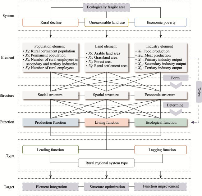
Figure 2 Framework of “element-structure-function” in the farming-pastoral ecotone of northern China

2.2.2 Construction of indicator system

The ecological function serves as the foundation and guarantee for living and production functions, with living and production activities needing to adhere to ecological environment protection principles. The improvement of the living function relies on the development of production activities. To evaluate the evolution of rural regional production, living, and ecological functions in FPENC, an indicator system was constructed based on the “element-structure-function” framework (Table 2). The production function exhibits obvious economic attributes, including agricultural, pastoral, and non-agricultural production functions. Per capita food production, per capita meat production, per capita arable land, per capita grassland, per capita agriculture and livestock output, and industry structure were selected to characterize production capacity and stability. The living function provides a living environment for farmers and herdsmen, with the non-farm employment rate, urbanization rate, rural population density, and per capita net income of farmers and herdsmen chosen to reflect the social, spatial, and economic structures, respectively. The ecological function impacts regional ecological security through conservation and supply aspects. To indicate ecological function, the biological richness index, forest and grassland coverage rate, normalized difference vegetation index (NDVI), per capita ecological system service value, and proportion of secondary industry output were selected.
Table 2 Indicator system for the evaluation of rural regional function evolution in the farming-pastoral ecotone of northern China
Function Structure Indicator formed by
elements
Definition Unit
Production Social Per capita food production Food production / Permanent population (+) t/person
Per capita meat production Meat production / Permanent population (+) t/person
Spatial Per capita arable land Arable land area / Rural permanent population (+) ha/person
Per capita grassland Grassland area / Rural permanent population (+) ha/person
Economic Per capita agriculture
and livestock output
Agriculture and livestock output / Rural permanent
population (+)
yuan/person
Industry structure Secondary and tertiary industry output / Regional GDP (+) %
Living Social Non-farm employment rate Number of rural employees in secondary and tertiary
industries / Number of rural employees (+)
%
Urbanization rate Urban permanent population / Permanent population (+) %
Spatial Rural population density Rural permanent population / Rural settlement area (+) person/ha
Economic Per capita net income of
farmers and herdsmen
Annual statistical yearbook data (+) yuan/person
Ecological Social Biological richness index Refer to the Technical Criterion for Ecosystem Status Evaluation issued by the Ministry of Ecology and Environment of the People's Republic of China (2015) (+) /
Spatial Forest and grassland coverage rate Forest and grassland area / Regional area (+) %
NDVI Normalized difference vegetation index (+) /
Per capita ecological system service value Refer to the method proposed by Costanza et al. (1997) and Xie et al. (2008) (+) yuan/person
Economic Proportion of secondary
industry output
Secondary industry output / Regional GDP (−) %

2.2.3 Evaluation of rural regional function

The entropy-based TOPSIS (Technique for Order of Preference by Similarity to Ideal Solution) model was employed to assess the evolution of rural regional functions. Using a dimensionless data matrix of rural regional function evaluation indicators, the weighted normalized matrix was obtained through the entropy method.
$\begin{matrix} {{\left\{ {{\text{y}}_{\text{ij}}} \right\}}_{\text{m}\times \text{n}}}~=~\left[ \begin{matrix} {{\text{y}}_{11}} & \cdots & {{\text{y}}_{1\text{n}}} \\ \vdots & \ddots & \vdots \\ {{\text{y}}_{\text{m}1}} & \cdots & {{\text{y}}_{\text{mn}}} \\ \end{matrix} \right]~=~\left[ \begin{matrix} {{\text{r}}_{11}}{{\text{w}}_{1}} & \cdots & {{\text{r}}_{1\text{n}}}{{\text{w}}_{\text{n}}} \\ \vdots & \ddots & \vdots \\ {{\text{r}}_{\text{m}1}}{{\text{w}}_{1}} & \cdots & {{\text{r}}_{\text{mn}}}{{\text{w}}_{\text{n}}} \\ \end{matrix} \right] \\ \end{matrix}$
where yij is the weighted normalized value of indicator j in the county unit i, rij is the normalized value of indicator j in the county unit i, wj is the indicator weight.
The rural regional function index is defined as the degree of closeness of evaluated objects to the ideal solution.
$\begin{matrix} {{\text{T}}_{\text{i}}}=\frac{\sqrt{\mathop{\sum }_{\text{j=}1}^{\text{n}}{{({{\text{y}}_{\text{ij}}}-\text{e}_{\text{j}}^{-})}^{2}}}}{\sqrt{\mathop{\sum }_{\text{j=}1}^{\text{n}}{{({{\text{y}}_{\text{ij}}}-\text{e}_{\text{j}}^{\text{+}})}^{2}}}\text{+}\sqrt{\mathop{\sum }_{\text{j=}1}^{\text{n}}{{({{\text{y}}_{\text{ij}}}-\text{e}_{\text{j}}^{-})}^{2}}}} \\ \end{matrix}$
where$\text{e}_{\text{j}}^{\text{+}}$is the maximum weighted normalized value of indicator j, $\text{e}_{\text{j}}^{-}$ is the minimum weighted normalized value of indicator j, the larger the closeness degree Ti, the higher function improvement degree of county unit i, and vice versa.
The triangular diagram, with the ratios of rural regional production, living, and ecological function indexes as the axes, was employed to analyze the relationship between rural regional functions.

2.2.4 Division of rural regional system types

To identify the leading and lagging functions, the revised vertical and horizontal comparison method (Long et al., 2009; Zhang et al., 2019) was utilized.
$\begin{matrix} \left\{ \begin{matrix} \frac{{{Z}_{ip}}}{{{M}_{p}}\text{+}{{S}_{p}}}\ge \text{0}\text{.75,}\ \text{Function}\ p\ \text{is the leading}\ \text{function}\ \text{of}\ \text{county}\ \text{unit}\ i \\ \frac{{{Z}_{ip}}}{{{M}_{p}}\text{+}{{S}_{p}}}\text{0}\text{.5,}\ \text{Function}\ p\ \text{is}\ \text{the}\ \text{lagging}\ \text{function}\ \text{of}\ \text{county}\ \text{unit}\ i \\ \end{matrix} \right. \\ \end{matrix}$
where Zip is the value of function p in the county unit i, Mp is the mean value of function p in all counties, and Sp is the standard deviation of function p in all counties.
The rural regional system type was determined by the arrangement and combination form of leading and lagging functions. Counties with only leading or lagging functions were classified as leading or lagging development types, respectively. Counties with neither leading nor lagging functions or both leading and lagging functions were classified as balanced or polarized development types, respectively. Additionally, subtypes were classified according to the stronger leading function or weaker lagging function (Table 3).
Table 3 Classification criteria of rural regional system types
Number of leading functions (N1) Number of lagging functions (N2) Subtype Type
0 < N1 < 3 N2 > 0 Leading production-lagging living (A1) Polarized development (A)
Leading production-lagging ecological (A2)
Leading living-lagging production (A3)
Leading living-lagging ecological (A4)
Leading ecological-lagging production (A5)
Leading ecological-lagging living (A6)
0 < N1 < 3 N2 = 0 Leading production (B1) Leading development (B)
Leading living (B2)
Leading ecological (B3)
N1 = 3 N2 = 0 Comprehensive development (B4)
N1 = 0 N2 > 0 Lagging production (C1) Lagging development (C)
Lagging living (C2)
Lagging ecological (C3)
N1 = 0 N2 = 0 Balanced development (D)

2.2.5 Analysis of driving factors

The GeoDetector model can assess the impact of an individual factor or the interaction effect of two different factors by analyzing the spatial distribution consistency (Wang and Xu, 2017). The individual effect of the driving factor (X) on the rural regional function index (Y) can be quantitatively described using the q-statistic by the factor detector model.
$\begin{matrix} q~=1-\frac{\text{1}}{N{{\sigma }^{\text{2}}}}\underset{h\text{=1}}{\overset{L}{\mathop \sum }}\,{{N}_{h}}\sigma _{h}^{\text{2}} \\ \end{matrix}$
where L is the number of strata of factor X, N and Nh mean the number of county units in the strata h and the whole region, respectively, and ${{\sigma }^{\text{2}}}$ and $\sigma _{h}^{\text{2}}$ represent the variance of index Y in the strata h and the whole region, respectively.
The interaction effect of two different factors on the rural regional function was calculated by q(X1X2) using the interaction detector model. The relationship can be divided into five categories by comparing q(X1X2) with q(X1) and q(X2) (Table 4).
Table 4 Relationship types of interaction between two different factors
Criterion Types of interaction
q(X1X2) < Min(q(X1), q(X2)) Nonlinear weakening Weakening
Min(q(X1), q(X2)) < q(X1X2) < Max(q(X1), q(X2)) Single-factor nonlinear weakening
q(X1X2) > Max(q(X1), q(X2)) Two-factor enhancement Enhancement
q(X1X2) > q(X1) + q(X2) Nonlinear enhancement
q(X1X2) = q(X1) + q(X2) Independent Independent

2.3 Data sources

The data utilized in this paper primarily consists of demographic data, socioeconomic statistics, and geographic information data from the years 2000, 2005, 2010, 2015, and 2020. Demographic data were mainly obtained from census information and statistical yearbooks, whereas socioeconomic statistics were mainly sourced from statistical yearbooks and statistical bulletins. Land use data and NDVI data were collected from the Resources and Environment Science and Data Center (http://www.resdc.cn/Default.aspx). Administrative boundary data were obtained from the National Earth System Science Data Center (http://www.geodata.cn). Throughout the study period, a few instances of missing data were replaced with the values from adjacent years. However, the data for Hongsibu District, Shuangluan District, Shuangqiao District, and Midokuchi Ranch were still missing in some years due to administrative division adjustments, inconsistent statistical calibers, and extensive missing data. Consequently, the final number of studied counties was 142 in 2000 and 2005 each, 143 in 2010 and 2015 each, and 145 in 2020.

3 Results

3.1 Structure characteristics of rural regional functions

The spatial structure played a relatively dominant role in determining rural regional production, living, and ecological functions, with significant weights of 0.38, 0.56, and 0.84, respectively (Table 5). Among the six positive indicators of the production function, per capita grassland had the most substantial impact with a weight of 0.26, and per capita agriculture and livestock output and per capita meat production also had significant effects with weights of 0.24 and 0.21, respectively. Rural population density (0.56) and per capita net income of farmers and herdsmen (0.26) contributed significantly to determining the living function. Per capita ecological system service value and the proportion of secondary industry output were the two important structural indicators of the ecological function, with weights of 0.51 and 0.16, respectively.
Table 5 Structure characteristics of rural regional functions in the farming-pastoral ecotone of northern China
Function Structure Indicator formed by elements Unit Weight
Production Social (0.35) Per capita food production t/person 0.14
Per capita meat production t/person 0.21
Spatial (0.38) Per capita arable land ha/person 0.12
Per capita grassland ha/person 0.26
Economic (0.27) Per capita agriculture and livestock output yuan/person 0.24
Industry structure % 0.03
Living Social (0.18) Non-farm employment rate % 0.08
Urbanization rate % 0.10
Spatial (0.56) Rural population density person/ha 0.56
Economic (0.26) Per capita net income of farmers and herdsmen yuan/person 0.26
Ecological Social (0.12) Biological richness index / 0.12
Spatial (0.72) Forest and grassland coverage rate % 0.09
NDVI / 0.12
Per capita ecological system service value yuan/person 0.51
Economic (0.16) Proportion of secondary industry output % 0.16

3.2 Spatiotemporal evolution patterns of rural regional functions

The indexes of rural regional production, living, and ecological functions exhibited an increasing trend during 2000−2020 (Figure 3a). The ecological function was dominant, with a higher average index value (0.27) than the other two functions. Additionally, the ecological function had significantly improved during 2010−2020, leading to rapid improvements in the production and living function indexes from 0.13 to 0.21 and 0.13 to 0.22, respectively.
Figure 3 The changes of the rural regional function average index (a) and the function relationship (b-f) in the farming-pastoral ecotone of northern China from 2000 to 2020
The relationship among rural regional functions gradually converged from 2000 to 2020 (Figures 3b-3f). The ratio of the county ecological and living function indexes ranged from [0.25,0.75] and [0,0.75] to [0.25,0.50], respectively. The ratio of the county production function index increased from [0.10,0.40] to [0.10,0.50]. Overall, a coordinated development trend was observed in production, living, and ecological functions.
Spatial differences in production and ecological function indexes had increased, whereas a significant decrease in spatial difference was found in the living function index during 2000−2020 (Figure 4). The production function index was higher in Shaanxi, Inner Mongolia, Hebei, and Liaoning, and lower in Ningxia, Gansu, and Shanxi (Figures 4a-4e). In 2000, a higher living function index was only found in Shaanxi (Figure 4f). However, there was comprehensive improvement in the living function in FPENC from 2005 to 2020 (Figures 4g-4j). The higher ecological function index was mainly concentrated in Hebei, Inner Mongolia, Liaoning, and southern Shaanxi without significant change in spatial pattern during 2000−2020. The lower and decreased ecological function index was found in some counties of northern Shaanxi (Figures 4k-4o).
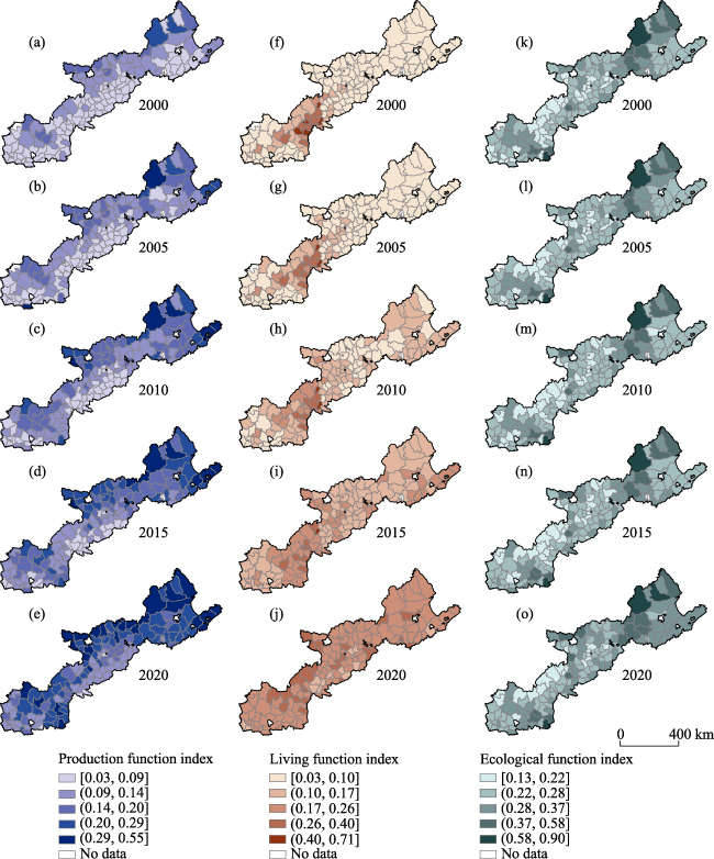
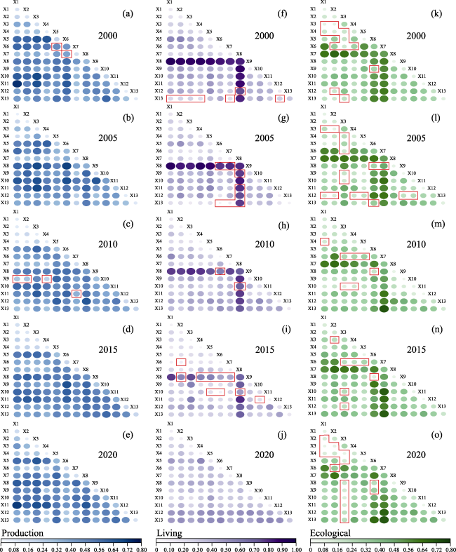
Figure 4 Spatiotemporal patterns of rural regional production (a-e), living (f-j), and ecological (k-o) function indexes in the farming-pastoral ecotone of northern China from 2000 to 2020

3.3 Transformation of rural regional system types

The proportion of leading development counties had increased from 9.86% to 55.63% during 2000−2020, whereas the proportions of polarized and lagging development counties had decreased from 52.82% to 26.06% and from 35.21% to 13.38%, respectively (Figure 5). The evolution trend from lagging development to polarized and balanced development types, and ultimately to leading development types was observed (Figure 5a). In 2000, leading production-lagging living, leading ecological-lagging living, and lagging living were the main types with proportions of 22.54%, 21.13%, and 32.39%, respectively, but these types decreased and even disappeared by 2015 (Figure 5b). The leading production-lagging living type mainly evolved into leading production and comprehensive development types, whereas the leading ecological-lagging living type gradually evolved into leading ecological, comprehensive development, and leading ecological-lagging production types. The lagging living type converted into leading living-lagging production, lagging production, and leading living types.
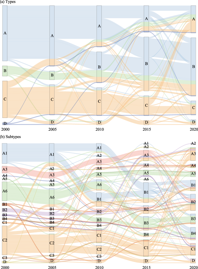
Figure 5 Transformation of rural regional system types (a) and subtypes (b) in the farming-pastoral ecotone of northern China from 2000 to 2020
Significant changes in the spatial pattern of rural regional system types were observed during 2000−2020 (Figure 6). Over 80% of polarized development counties were leading production-lagging living and leading ecological-lagging living in 2000 (Figures 6a-6e). By 2020, leading living-lagging production and leading ecological-lagging production were mainly found in a few counties of Hebei, Shanxi, and Gansu, whereas leading living-lagging ecological was concentrated in northern Shaanxi. The increased leading development counties mainly occurred in the northeast part of FPENC during 2000−2020 (Figures 6f-6j). The leading ecological and comprehensive development counties were mainly found in Inner Mongolia, Hebei, and Shaanxi. The decreased lagging living counties were located in the southern part of FPENC, including Liaoning, Shanxi, Gansu, and Ningxia, whereas the increased lagging production counties were concentrated in Shanxi, Gansu, and Ningxia (Figures 6k-6o).
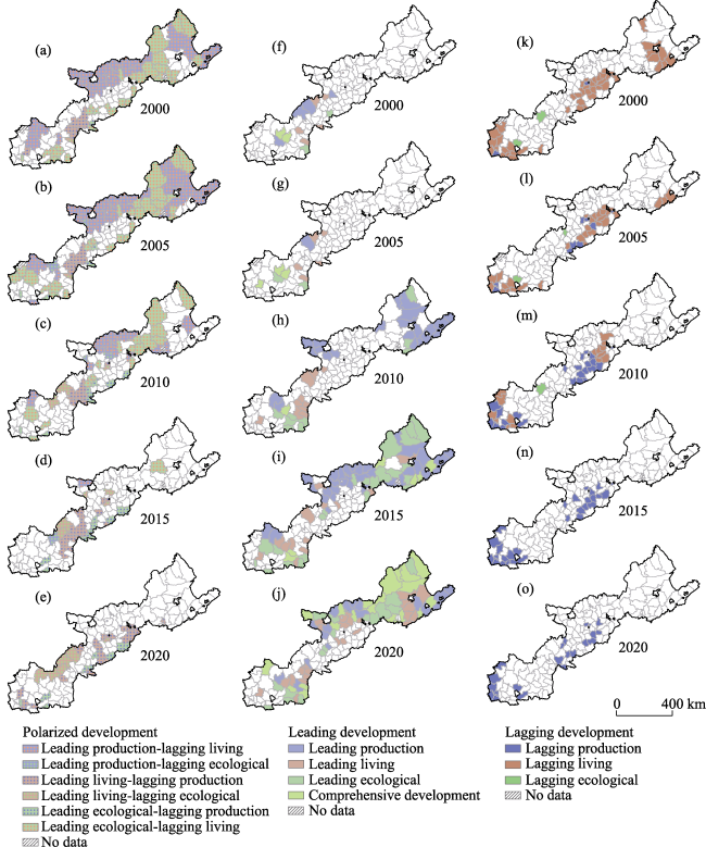
Figure 6 Spatiotemporal transformation of polarized (a-e), leading (f-j), and lagging (k-o) development types of rural regional system in the farming-pastoral ecotone of northern China from 2000 to 2020

3.4 Driving factors of rural regional function evolution

Land and industry elements were the main driving factors of rural regional functions, whereas the effects of the population element were relatively weak (Table 6). In 2000, grassland area and rural settlement area were the main driving factors, which evolved to rural settlement area, arable land area, meat production, primary industry output, and grassland area in 2020. Rural settlement area had a higher but gradually weakening influence on the living function, whereas significant effects were also found in industry elements, which evolved from food production, meat production, and primary industry output to secondary and tertiary industry output during 2000−2020. Forest area and grassland area were the main driving factors of the ecological function. The explanatory power of forest area decreased from 0.53 in 2000 to 0.38 in 2020, whereas the explanatory power of grassland area decreased from 0.36 in 2000 to 0.32 in 2010 and then increased to 0.36 in 2020.
Table 6 Driving factor detection results of rural regional function evolution in the farming-pastoral ecotone of northern China from 2000 to 2020
Factor Production function (Y1) Living function (Y2) Ecological function (Y3)
2000 2005 2010 2015 2020 2000 2005 2010 2015 2020 2000 2005 2010 2015 2020
Population X1 0.12** 0.05 0.08 0.14 0.16* 0.13** 0.15 0.13** 0.07 0.09 0.08 0.08 0.14 0.13 0.09
X2 0.12** 0.08 0.07 0.10 0.07 0.14** 0.17** 0.08* 0.12 0.10 0.13 0.14 0.16 0.16 0.19
X3 0.15** 0.12* 0.07 0.12 0.11 0.10* 0.06 0.06 0.05 0.10 0.29** 0.35 0.16 0.26 0.29***
X4 0.08 0.10 0.08 0.10 0.06 0.16 0.15** 0.06 0.04 0.08 0.16 0.14 0.16 0.14 0.16
Land X5 0.21** 0.24 0.29*** 0.31*** 0.33*** 0.15** 0.17*** 0.06 0.17 0.16** 0.07 0.06 0.06 0.07 0.07
X6 0.45*** 0.32** 0.24 0.19 0.19*** 0.04 0.07 0.04 0.06 0.08 0.36** 0.36** 0.32* 0.33* 0.36**
X7 0.15 0.12 0.16 0.18* 0.14** 0.14** 0.12* 0.06 0.09 0.10 0.53*** 0.52*** 0.38** 0.39** 0.38**
X8 0.32*** 0.36*** 0.43*** 0.46*** 0.36*** 0.84*** 0.82*** 0.72*** 0.69*** 0.26 0.07 0.08 0.07 0.07 0.09
Industry X9 0.12* 0.17 0.30** 0.27*** 0.15** 0.12* 0.26*** 0.14** 0.18** 0.06 0.12*** 0.05 0.05 0.10 0.07
X10 0.22** 0.42*** 0.39*** 0.42*** 0.32*** 0.27*** 0.24*** 0.21* 0.22 0.06 0.10 0.10 0.08 0.08 0.19
X11 0.14** 0.26*** 0.37*** 0.36*** 0.29*** 0.21*** 0.29*** 0.24*** 0.07 0.10 0.06 0.06 0.05 0.04 0.05
X12 0.07 0.08 0.18*** 0.19** 0.10 0.13** 0.09 0.12** 0.18*** 0.27*** 0.20 0.25 0.20 0.20** 0.16**
X13 0.09 0.09 0.21 0.19*** 0.13* 0.31*** 0.07 0.12** 0.14 0.31*** 0.11 0.10 0.15*** 0.18* 0.15**

Notes: X1: Rural permanent population, X2: Permanent population, X3: Number of rural employees in secondary and tertiary industries, X4: Number of rural employees, X5: Arable land area, X6: Grassland area, X7: Forest area, X8: Rural settlement area, X9: Food production, X10: Meat production, X11: Primary industry output, X12: Secondary industry output, X13: Tertiary industry output. *, **, and*** indicate significance levels of 10%, 5%, and 1%, respectively.

The driving force of individual factors for the production, living, and ecological functions was mostly smaller than the interaction effect (Figure 7). During 2000−2020, arable land area, rural settlement area, meat production, and primary industry output interacting with population elements had significant effects on the production function (Figures 7a-7e). Additionally, interactions between land and industry elements also contributed noticeable impacts, such as rural settlement area interacting with primary industry output and grassland area interacting with meat production. From 2000 to 2015, interactions between rural settlement area and other factors had a higher but gradually weakening influence on the living function (Figures 7f-7j). Meanwhile, interactions between rural settlement area and population elements had higher explanatory power than the individual effect during 2000−2010. The interactions between forest area and other factors had a higher but gradually weakening influence on the ecological function from 2000 to 2020 (Figures 7k-7o). Grassland area interacting with rural permanent population and tertiary industry output also contributed noticeable impacts, decreasing from 0.61 and 0.60 in 2000 to 0.32 and 0.51 in 2010 and then increasing to 0.60 and 0.67 in 2020, respectively.
Figure 7 Interaction results of driving factor for rural regional production (a-e), living (f-j), and ecological (k-o) function evolution in the farming-pastoral ecotone of northern China from 2000 to 2020

Note: The red frames indicate weakening, others indicate enhancement.

4 Discussion

4.1 Synergy trend of rural regional functions

The synergy of rural regional production, living, and ecological functions was found in FPENC from 2000 to 2020 (Figure 3). The significantly improved ecological function had led to a rapid improvement in production and living functions, indicating that a good ecological conservation and supply capacity are an essential foundation for increasing productivity and improving living standards. This result is in line with previous studies (Tan et al., 2019; Bai et al., 2022; Qian et al., 2022; Wen et al., 2022). The significantly improved production function in Shaanxi, Inner Mongolia, Hebei, and Liaoning during 2000−2020 (Figures 4a-4e) may be a result of the implementation of the “Grain for Green” project, which brought about significant ecological and economic benefits (Jian et al., 2022). Additionally, the northern Shaanxi region, located at the junction of Mu Us Sandy Land and Loess Plateau, had made pronounced progress in rural production capacity through afforestation practices (Pei et al., 2021), sandy land consolidation (Wang and Liu, 2020), and gully land consolidation projects (Li et al., 2019a; Wang et al., 2020). The rural living function had been overall improved from 2000 to 2020, with further decreased regional differences during 2015−2020 (Figures 4f-4j). These results may be attributed to the significant improvement in the economic income and living standards of farmers and herdsmen from targeted poverty alleviation strategies in FPENC (Li et al., 2019d). However, the spatial pattern of rural ecological function had not changed significantly (Figures 4k-4o). Higher ecological function was still found in Hebei, Inner Mongolia, Liaoning, and Shaanxi with relatively higher rainfall and vegetation cover (Ouyang et al., 2016; Liu et al., 2018b).
A transformation trend of rural regional system types from lagging development to polarized development, and then to leading development, was found in FPENC from 2000 to 2020 (Figure 5a). Leading ecological and comprehensive development counties located in Inner Mongolia, Hebei, and Shaanxi mainly evolved from leading production-lagging living and leading ecological-lagging living types. Leading production and leading living counties concentrated in Liaoning, Inner Mongolia, and Shaanxi mainly evolved from leading production-lagging living and lagging living types, respectively (Figures 5 and 6f-6j). These results imply that the improvement of rural living function plays an important role in the formation of leading development types over the past 20 years in FPENC. About 76% of counties with lagging living function have all developed to non-lagging types, indicating the significant role of national economic development and poverty alleviation policies for rural development (Ren et al., 2018). The implementation of ecological projects has improved vegetation coverage and the ecological environment but triggered a new human-land contradiction with the rapid decrease of farmland and shortage of grain, especially in the loess hilly and gully region (Chen et al., 2015; Li et al., 2019b). Therefore, conflicts between rural ecological function and production and living functions were found in Shanxi, Gansu, and Ningxia (Figure 6).

4.2 Driving mechanisms of rural regional function evolution

Optimizing rural production, living, and ecological spaces is crucial for rural regional function development (Tu and Long, 2017). This study also found that spatial structure played a dominant role in determining rural regional functions (Table 2). Multiple factors affect the rural function evolution in different degrees and ways (Tan et al., 2019). The evolution of rural regional function in FPENC was jointly affected by population, land, and industry elements, with greatly varied influence degrees at different periods. Land and industry were identified as the dominant driving factors (Table 5). These results are consistent with previous studies (Zhang et al., 2018; Feng et al., 2019; Liu et al., 2020b).
The driving force of industry elements for the production function had increased during 2000−2020 (Table 5). This may result from agriculture and livestock structure adjustment and industrial transformation. Population growth and food consumption structure upgrading posed challenges to the sustainable development of livestock under ecological environment protection and economic development in FPENC (Guo and Liu, 2022). The driving factors of living function had changed from rural settlement area and primary industry to secondary and tertiary industry since 2015 (Table 5 and Figures 7f-7j). These may be due to the increased wage income proportion of farmers and herdsmen with the development of industrialization and urbanization. During 2000−2015, hollowed village consolidation and central village construction aiming to improve land use efficiency and retain rural population (Shi and Wang, 2021) had also improved the living standards of farmers and herdsmen (Liu et al., 2013). Liu et al. (2021b) found that forestland expansion and grassland shrinkage reduced vegetation cover and even produced a negative impact on ecological system service in arid and semi-arid areas such as FPENC. In this study, forest area and grassland area had been the main driving factors of ecological function during 2000−2020 (Table 5). Therefore, the effects of grassland area interacting with industry elements had increased since 2010 (Figures 7k-7o).
Overall, tertiary industry output, grassland area, forest area, and arable land area had contributed noticeable impacts on the synergistic development of rural regional production, living, and ecological functions (Table 5), indicating the importance of restoring and maintaining the land ecology. Grassland has many ecological functions of soil and water conservation, wind and sand control, climate regulation, and biodiversity maintenance, as well as production functions of grass and livestock production (Yang et al., 2015). The development of ecological grass husbandry and ecotourism not only plays an important role in regional ecological improvement but also provides a new pathway for industrial development and living improvement (Han et al., 2022).

4.3 Differentiated development strategies of rural regional function

Rural development policies in the future should be formulated through regional categorization. Optimization of the leading functions and improvement of the lagging functions are the principles of rural development policymaking in FPENC. Differentiated rural development strategies should be designed to promote the synergies of the rural regional functions in three different regions and 10 different types (Table 7). First, the ecological dominance regions mainly focus on preventing farmers and herdsmen from returning to poverty. More investments and attention should be given to the transformation of traditional agriculture to ecological grass husbandry and ecotourism (Liu et al., 2021a; Zanetti et al., 2021). Second, rural production and residential land can be enhanced by the implementation of comprehensive land consolidation (Liu et al., 2020b; Shi and Wang, 2021). In the priority development regions, efforts need to be made in adjusting agriculture and livestock structure and improving the quality and quantity of labor force. Lastly, the coordinated development regions play the demonstration role of coordinated development of rural functions. Innovative land engineering techniques and sustainable land use models (Liu and Wang, 2019; Bai et al., 2022) need to be summarized and popularized for other regions to improve the land quality and productivity and to provide a foundation for the integration of three industries and new livelihood for rural households.
Table 7 Differentiated development strategies of rural regional functions in the farming-pastoral ecotone of northern China
Region Type Strategy
Ecological dominance
(Gansu, Ningxia, Shanxi, and Hebei)
Leading ecological
Leading ecological-lagging production
Lagging production
Balanced development
Prevent farmers and herdsmen from returning to poverty.
Restore and protect the grassland ecosystems.
Promote the development of ecological grass husbandry and ecotourism.
Priority development
(Shaanxi, Liaoning, and middle of Inner Mongolia)
Leading production
Leading production-lagging ecological
Leading living-lagging production
Leading living-lagging ecological
Leading living
Improve the quality and quantity of labor force.
Implement the comprehensive land consolidation.
Adjust agriculture and livestock structure.
Coordinated development
(Northeast of Inner
Mongolia)
Comprehensive development Play the demonstration role.
Restore and maintain the land ecology.
Promote the integration of three industries.
Although the evolution characteristics and driving factors of rural regional functions in FPENC were explored during 2000 to 2020 using multi-source data, including demographic data, socioeconomic statistics, and geographic information data, the lack of investigation data, especially the regional cultural data and industry employment data, gave the evaluation uncertainty of the living and ecological functions, respectively. In addition, the detection results indicated the effect degree of the factors on rural functions rather than the specific direction.

5 Conclusions

The indicator system was constructed to explore the evolution characteristics and driving mechanisms of rural regional functions in FPENC during 2000−2020, based on the framework of “element-structure-function”. The study revealed synergies among rural regional production, living, and ecological functions in FPENC, with ecological function identified as the dominant function. Higher ecological function was found in Hebei, Inner Mongolia, and Shaanxi, accompanied by significant improvements in production and living functions. However, conflicts between ecological function and production and living functions were observed in Shanxi, Gansu, and Ningxia. The number of leading development counties increased due to overall improvements in rural living function. Spatial structure played a dominant role in the changes observed in rural production, living, and ecological functions. Land and industry were identified as the dominant driving factors for the evolution of rural regional functions. The driving force of industry elements for the production function had increased over time. Rural settlement area, when interacting with other factors, showed a weakening influence on living function, whereas the effects of secondary and tertiary industry output had increased. Forest area had a decreasing impact on ecological function, whereas grassland area had an increasing impact. In the future, a strategy for integrating ecological protection and industrial development should be established to promote the synergistic development of rural regional functions in FPENC.
[1]
Bai Y, Liu Y, Li Y et al., 2022. Land consolidation and eco-environmental sustainability in Loess Plateau: A study of Baota district, Shaanxi province, China. Journal of Geographical Sciences, 32(9): 1724-1744.

DOI

[2]
Beardmore L, Heagney E, Sullivan C A, 2019. Complementary land use in the Richmond River catchment: Evaluating economic and environmental benefits. Land Use Policy, 87: 104070.

DOI

[3]
Chen R, Ye C, Cai Y et al., 2014. The impact of rural out-migration on land use transition in China: Past, present and trend. Land Use Policy, 40: 101-110.

DOI

[4]
Chen X, Jiang L, Zhang G et al., 2021. Green-depressing cropping system: A referential land use practice for fallow to ensure a harmonious human-land relationship in the farming-pastoral ecotone of northern China. Land Use Policy, 100: 104917.

DOI

[5]
Chen Y, Wang K, Lin Y et al., 2015. Balancing green and grain trade. Nature Geoscience, 8: 739-741.

DOI

[6]
Cheng M, Chen H, 2023. Spatio-temporal evolution of the rural regional system and its evolution mechanism in Huang-Huai-Hai area of China. Chinese Geographical Science, 33(1): 51-68.

DOI

[7]
Costanza R, Darge R, Degroot R et al., 1997. The value of the world's ecosystem services and natural capital. Nature, 387: 253-260.

DOI

[8]
Feng W, Liu Y, Qu L, 2019. Effect of land-centered urbanization on rural development: A regional analysis in China. Land Use Policy, 87: 104072.

DOI

[9]
Feng X, Fu B, Piao S et al., 2016. Revegetation in China's Loess Plateau is approaching sustainable water resource limits. Nature Climate Change, 6: 1019-1022.

DOI

[10]
Gao S, Duan R, Wang H et al., 2021. Farming-pastoral ecotone of northern China plays important role in ensuring national food security. Bulletin of Chinese Academy of Sciences, 36(6): 643-651. (in Chinese)

[11]
Guo Y, Liu Y, 2022. Sustainable poverty alleviation and green development in China's underdeveloped areas. Journal of Geographical Sciences, 32(1): 23-43.

DOI

[12]
Han C, Wang G, Yang H, 2022. Study on the coupling system of grain-grass-livestock of herbivorous animal husbandry in agricultural areas: A case study of Najitun farm of Hulunbuir agricultural reclamation in China. Land, 11(5): 691.

DOI

[13]
Hansen J, Hellin J, Rosenstock T et al., 2019. Climate risk management and rural poverty reduction. Agricultural Systems, 172: 28-46.

DOI

[14]
Jian Y, Liu Z, Gong J, 2022. Response of landscape dynamics to socio-economic development and biophysical setting across the farming-pastoral ecotone of northern China and its implications for regional sustainable land management. Land Use Policy, 122: 106354.

DOI

[15]
Li Y, Li Y, Fan P et al., 2019a. Impacts of land consolidation on rural human-environment system in typical watershed of the Loess Plateau and implications for rural development policy. Land Use Policy, 86: 339-350.

DOI

[16]
Li Y, Li Y, Fan P et al., 2019b. Land use and landscape change driven by gully land consolidation project: A case study of a typical watershed in the Loess Plateau. Journal of Geographical Sciences, 29(5): 719-729.

DOI

[17]
Li Y, Westlund H, Liu Y, 2019c. Why some rural areas decline while some others not: An overview of rural evolution in the world. Journal of Rural Studies, 68: 135-143.

DOI

[18]
Li Y, Zhao X, Liu X et al., 2019d. Research in desertification mechanism and reversion techniques promotes sustainable restoration of degraded ecosystem and agro-pastoral development. Bulletin of Chinese Academy of Sciences, 34(7): 832-840. (in Chinese)

[19]
Liu C, Xu Y, Lu X et al., 2021a. Trade-offs and driving forces of land use functions in ecologically fragile areas of northern Hebei province: Spatiotemporal analysis. Land Use Policy, 104: 105387.

DOI

[20]
Liu D, Chen J, Ouyang Z, 2020a. Responses of landscape structure to the ecological restoration programs in the farming-pastoral ecotone of northern China. Science of the Total Environment, 710: 136311.

DOI

[21]
Liu M, Jia Y, Zhao J et al., 2021b. Revegetation projects significantly improved ecosystem service values in the agro-pastoral ecotone of northern China in recent 20 years. Science of the Total Environment, 788: 147756.

DOI

[22]
Liu W, Yang C, Liu Y et al., 2018a. Impacts of concentrated rural resettlement policy on rural restructuring in upland areas: A case study of Qiantang Town in Chongqing, China. Land Use Policy, 77: 732-744.

DOI

[23]
Liu Y, 2018. Research on the urban-rural integration and rural revitalization in the new era in China. Acta Geographica Sinica, 73(4): 637-650. (in Chinese)

DOI

[24]
Liu Y, Fang F, Li Y, 2014. Key issues of land use in China and implications for policy making. Land Use Policy, 40: 6-12.

DOI

[25]
Liu Y, Li Y, 2017. Revitalize the world's countryside. Nature, 548: 275-277.

DOI

[26]
Liu Y, Lu S, Chen Y, 2013. Spatio-temporal change of urban-rural equalized development patterns in China and its driving factors. Journal of Rural Studies, 32: 320-330.

DOI

[27]
Liu Y, Wang Y, 2019. Rural land engineering and poverty alleviation: Lessons from typical regions in China. Journal of Geographical Sciences, 29(5): 643-657.

DOI

[28]
Liu Y, Zang Y, Yang Y, 2020b. China's rural revitalization and development: Theory, technology and management. Journal of Geographical Sciences, 30(12): 1923-1942.

DOI

[29]
Liu Z, Liu Y, Li Y, 2018b. Anthropogenic contributions dominate trends of vegetation cover change over the farming-pastoral ecotone of northern China. Ecological Indicators, 95: 370-378.

DOI

[30]
Long H, Liu Y, Zou J, 2009. Assessment of rural development types and their rurality in eastern coastal China. Acta Geographica Sinica, 64(4): 426-434. (in Chinese)

DOI

[31]
Long H, Ma L, Zhang Y et al., 2022. Multifunctional rural development in China: Pattern, process and mechanism. Habitat International, 121: 102530.

DOI

[32]
Long H, Tu S, Ge D et al., 2016. The allocation and management of critical resources in rural China under restructuring: Problems and prospects. Journal of Rural Studies, 47: 392-412.

DOI

[33]
Markey S, Halseth G, Manson D, 2008. Challenging the inevitability of rural decline: Advancing the policy of place in northern British Columbia. Journal of Rural Studies, 24(4): 409-421.

DOI

[34]
McDonald C, Kirk-Brown A, Frost L et al., 2013. Partnerships and integrated responses to rural decline: The role of collective efficacy and political capital in Northwest Tasmania, Australia. Journal of Rural Studies, 32: 346-356.

DOI

[35]
Ministry of Agriculture and Rural Affairs of the People's Republic of China MARAPRC, 2016. Guiding opinions of Ministry of Agriculture on agricultural structure adjustment in northern farming and pastoral ecotone. Gazette of the Ministry of Agriculture of the People's Republic of China, 12: 7-12.

[36]
Ministry of Ecology and Environment of the People's Republic of China MEEPRC, 2015. Technical Criterion for Ecosystem Status Evaluation, HJ 192-2015. Beijing: China Environmental Science Press.

[37]
Ongley E D, Zhang X, Yu T, 2010. Current status of agricultural and rural non-point source pollution assessment in China. Environmental Pollution, 158(5): 1159-1168.

DOI PMID

[38]
Ouyang Z, Zheng H, Xiao Y et al., 2016. Improvements in ecosystem services from investments in natural capital. Science, 352(6292): 1455-1459.

DOI PMID

[39]
Parry L, Day B, Amaral S et al., 2010. Drivers of rural exodus from Amazonian headwaters. Population and Environment, 32: 137-176.

DOI

[40]
Pei H, Liu M, Jia Y et al., 2021. The trend of vegetation greening and its drivers in the agro-pastoral ecotone of northern China, 2000-2020. Ecological Indicators, 129: 108004.

DOI

[41]
Qian M, Cheng Z, Wang Z et al., 2022. What affects rural ecological environment governance efficiency? Evidence from China. International Journal of Environmental Research and Public Health, 19(10): 5925.

DOI

[42]
Ren Q, He C, Huang Q et al., 2018. The poverty dynamics in the agro-pastoral transitional zone in northern China: A multiscale perspective based on the poverty gap index. Resources Science, 40(2): 404-416. (in Chinese)

[43]
Shi L, Wang Y, 2021. Evolution characteristics and driving factors of negative decoupled rural residential land and resident population in the Yellow River Basin. Land Use Policy, 109: 105685.

DOI

[44]
Tan X, Ouyang Q, An Y et al., 2019. Evolution and driving forces of rural functions in urban agglomeration: A case study of the Chang-Zhu-Tan region. Journal of Geographical Sciences, 29(8): 1381-1395.

DOI

[45]
Thapa R B, Murayama Y, 2010. Drivers of urban growth in the Kathmandu valley, Nepal: Examining the efficacy of the analytic hierarchy process. Applied Geography, 30(1): 70-83.

DOI

[46]
Tu S, Long H, 2017. Rural restructuring in China: Theory, approaches and research prospect. Journal of Geographical Sciences, 27(10): 1169-1184.

DOI

[47]
Uisso A M, Tanrıvermiş H, 2021. Driving factors and assessment of changes in the use of arable land in Tanzania. Land Use Policy, 104: 105359.

DOI

[48]
Wang J, Xu C, 2017. Geodetector: Principle and prospective. Acta Geographica Sinica, 72(1): 116-134. (in Chinese)

DOI

[49]
Wang Y, Cui X, Zou L et al., 2023. Differentiated discharge patterns, causes and prevention measures of rural non-point source pollution in the four economic regions of mainland of China. Journal of Rural Studies, 98: 114-122.

DOI

[50]
Wang Y, Li Y, Li Y, 2020. Land engineering consolidates degraded sandy land for agricultural development in the largest sandy land of China. Land, 9(6): 199.

DOI

[51]
Wang Y, Liu Y, 2020. New material for transforming degraded sandy land into productive farmland. Land Use Policy, 92: 104477.

DOI

[52]
Wei Y, An P, Jin Y et al., 2021. Population aging and its farmland effect on abandonment in the northern farming-pastoral ecotone: A case study of Ulanqab. Journal of Arid Land Resources and Environment, 35(7): 64-70. (in Chinese)

[53]
Wen Q, Shen C, Xia S et al., 2022. Analysis of spatiotemporal variations and effects of regional functions in rural China. Growth and Change, 53(3): 1414-1435.

DOI

[54]
Willemen L, Hein L, Van Mensvoort M E F et al., 2010. Space for people, plants, and livestock? Quantifying interactions among multiple landscape functions in a Dutch rural region. Ecological Indicators, 10(1): 62-73.

DOI

[55]
Wuyun D, Sun L, Chen Z et al., 2022. The spatiotemporal change of cropland and its impact on vegetation dynamics in the farming-pastoral ecotone of northern China. Science of the Total Environment, 805: 150286.

DOI

[56]
Xiang D, Verbruggen E, Hu Y et al., 2014. Land use influences arbuscular mycorrhizal fungal communities in the farming-pastoral ecotone of northern China. New Phytologist, 204(4): 968-978.

DOI PMID

[57]
Xie G, Zhen L, Lu C et al., 2008. Expert knowledge based valuation method of ecosystem services in China. Journal of Natural Resources, 23(5): 911-919. (in Chinese)

DOI

[58]
Yang X, Xu B, Jin Y et al., 2015. Remote sensing monitoring of grassland vegetation growth in the Beijing-Tianjin sandstorm source project area from 2000 to 2010. Ecological Indicators, 51: 244-251.

DOI

[59]
Yang Y, Bao W, Liu Y, 2020a. Coupling coordination analysis of rural production-living-ecological space in the Beijing-Tianjin-Hebei region. Ecological Indicators, 117: 106512.

DOI

[60]
Yang Y, Liu Y, Li Y et al., 2018. Measure of urban-rural transformation in Beijing-Tianjin-Hebei region in the new millennium: Population-land-industry perspective. Land Use Policy, 79: 595-608.

DOI

[61]
Yang Y, Wang K, Liu D et al., 2020b. Effects of land-use conversions on the ecosystem services in the agro-pastoral ecotone of northern China. Journal of Cleaner Production, 249: 119360.

DOI

[62]
Yao Y, Ge N, Yu S et al., 2019. Response of aggregate associated organic carbon, nitrogen and phosphorous to re-vegetation in agro-pastoral ecotone of northern China. Geoderma, 341: 172-180.

DOI

[63]
Zanetti F, Alberghini B, Marjanović Jeromela A et al., 2021. Camelina, an ancient oilseed crop actively contributing to the rural renaissance in Europe. A review. Agronomy for Sustainable Development, 41: 2.

DOI

[64]
Zhang L, Wang Z, Wei C et al., 2019. Rural revitalization strategy based on the perspective of rural multifunctions: A case of the mountainous areas in Yunyang district of Shiyan city, western Hubei province. Resources Science, 41(9): 1703-1713. (in Chinese)

[65]
Zhang Y, Su Z, Li G et al., 2018. Spatial-temporal evolution of sustainable urbanization development: A perspective of the coupling coordination development based on population, industry, and built-up land spatial agglomeration. Sustainability, 10(6): 1766.

DOI

[66]
Zhou D, Xu J, Lin Z, 2017. Conflict or coordination? Assessing land use multifunctionalization using production-living-ecology analysis. Science of the Total Environment, 577: 136-147.

DOI

[67]
Zhu L, Wang T, Xia D, 2021. The identification of county-level rural territorial function types and research on rural revitalization path in Sichuan province. Tropical Geography, 41(4): 870-880. (in Chinese)

DOI

[68]
Zou L, Liu Y, Wang J et al., 2021. An analysis of land use conflict potentials based on ecological-production-living function in the southeast coastal area of China. Ecological Indicators, 122: 107297.

DOI

Outlines

/