Land-use planning in China: Past, present, and future

  • CHEN Wanxu , 1, 2 ,
  • PAN Sipei 3 ,
  • YE Xinyue , 4, *
Expand
  • 1. Department of Geography, School of Geography and Information Engineering, China University of Geosciences, Wuhan 430074, China
  • 2. Research Center for Spatial Planning and Human-Environmental System Simulation, China University of Geosciences, Wuhan 430074, China
  • 3. School of Public Administration, China University of Geosciences, Wuhan 430074, China
  • 4. Department of Landscape Architecture and Urban Planning, Texas A&M University, College Station, TX 77840, USA
*Ye Xinyue (1974-), Professor, E-mail:

Chen Wanxu (1989-), Associate Professor, specialized in resource and environment assessment and regional economic analysis. E-mail:

Received date: 2022-11-11

  Accepted date: 2023-02-15

  Online published: 2023-07-24

Supported by

National Natural Science Foundation of China(42001187)

Abstract

Under the framework of ecological civilisation, the formulation of territorial spatial planning (TSP) and improvement of spatial governance systems are of great practical significance. Since the founding of the People’s Republic of China, land-use planning (LUP) has experienced profound changes, and tremendous research efforts have been made in that field. However, systematic studies on LUP history are scarce. To bridge the existing gap, this study traced back to the emergence of LUP, described its practice stages, and analysed the evolution of its classification system and methods. Further, the three rounds of general LUP practice and the current TSP over the past 40 years of the reform and opening-up have been discussed. The evolution of LUP was found to be closely related to economic development and could be broadly divided into four stages. The development of land-use classification in China has been slow and can be divided into five stages according to the evolution of the land classification system and important historical events. The development of LUP methods can be divided into two stages, before and after 1978. Since the economic reform, China has successively conducted three rounds of general LUP under different institutional and policy backgrounds. Future development should aim to innovate the theories and methods of TSP with Chinese characteristics and promote the study of village planning and the construction of TSP systems to achieve rural revitalisation and ecological civilisation.

Cite this article

CHEN Wanxu , PAN Sipei , YE Xinyue . Land-use planning in China: Past, present, and future[J]. Journal of Geographical Sciences, 2023 , 33(7) : 1527 -1552 . DOI: 10.1007/s11442-023-2141-7

1 Introduction

As a core pillar of territorial policy, land-use planning (LUP) is necessary for a sustainable land management and territorial policy making (Damurski and Oleksy, 2018; Zysk et al., 2020). The definition of LUP varies according to the sources. Food and Agriculture Organization of the United Nations (FAO, 1993) defined LUP as a systematic evaluation process of land and water resources potential as well as changes in land use and socioeconomic conditions. In China, LUP refers to an advanced plan for future land use in a certain region (Wang, 2000). However, in most Western countries, LUP is equivalent to city- or county-level planning. Among them, differences can be observed in their system composition and theoretical methods (Dan and Wang, 2002). Although LUP systems in Western countries are not as independent as in China, they are complete systems, ranging from national to regional scales (Dan and Wang, 2002). While zoning is the most widely used LUP method in Western countries, China has experienced different changes in LUP in different periods (Dong, 2007).
Within the context of rapid urbanisation, LUP is a basic tool for efficiently governing urban sprawl in China (Shen et al., 2019; Guo et al., 2020). However, many empirical studies showed that LUP failed to deliver sustainable development outcomes (Boamah et al., 2012; Siiba et al., 2018), most notably in developing countries undergoing rapid urbanisation (Xu et al., 2019). In European countries, LUP is often considered as the main cause of housing shortages and high prices (Lord and Tewdwr-Jones, 2014). By contrast, LUP is used to influence urban expansion and promote local economic development through zoning restrictions in China (Wu, 2015). However, LUP at the village level in China tends to overlook the risks inherent in land-use change (Yan J et al., 2021). Although many villages have compiled village-level LUP, such planning fails to incorporate sustainability goals, and its accompanying future risks have not been adequately considered (Fidelis and Rodrigues, 2019; Pena et al., 2020).
In recent years, research on LUP has grown, focusing on ecological issues (Che et al., 2021; Zhu et al., 2022), public participation (Kopáček, 2021), risk assessment (Yan J et al., 2021), implementation effect estimation (Zhou et al., 2017), policy (Wang J et al., 2012; 2020; Ge and Lu, 2021), and comparative research (Pan et al., 2023). While abundant research can be found on land-use policy (Qu et al., 2021), land systems (Liu, 2021; Yan J M et al., 2021), and cultivated land protection (Niu and Fang, 2019), the development process of LUP in China has not been comprehensively established yet. LUP in China has a long history that can be traced back to the settlement planning of the Shang Dynasty, the ‘well-field system’ of the Zhou Dynasty, and the ‘square field system’ of the Song Dynasty (Zong, 2004). However, LUP was only conducted in an organised and comprehensive manner after the founding of the People’s Republic of China (PRC) in 1949 (Yu, 2008). China’s LUP has gone through several important periods and has been successively conducted from the restoration of the national economy until the reform and opening-up (ROU) period (Dong, 2007). After the ROU, the promulgation of the ‘Land Administration Law’, and the establishment of the Bureau of Land Administration, China’s LUP has advanced significantly (Lai et al., 2020). However, there are few reports on the long-term evolution of LUP in China, as most studies were conducted after the ROU (Liang et al., 2005; Lin et al., 2017). Systematic examination of the past, present, and future of LUP in China since 1949 is of great significance to understand the spatial, socioeconomic dynamics, and guiding future of LUP. Therefore, a comprehensive review of the development processes of China’s LUP after the founding of the PRC is of practical significance.

2 LUP practices since 1949

Since 1949, China has considered LUP as an important means of adjusting land relations and consolidating the public ownership of socialist land (Dong, 2007). The evolution of LUP from 1949 can be divided into four stages: (1) the initial development of a planned economy (1949-1978), (2) the transition from the planned economy to a market economy (1978-2000), (3) the gradual improvement during the initial establishment of the market economy (2000-2013), and (4) the new normal era (2013 onward). Figure 1 presents the most important LUP practice documents in these four stages.
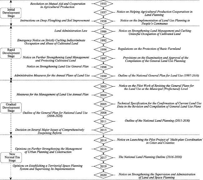
Figure 1 Important policies of land-use planning practices in China since 1949

2.1 Initial development stage of the planned economy from 1949 to 1978

To develop an agricultural economy, State Farms were widely built throughout China, and the role of LUP gradually emerged (Zong, 2004). In the ‘First Five-Year Plan’ period from 1953 to 1957, land management was gradually transformed from decentralised to centralised (Dong, 2007). The government reformed private ownership of urban land with a redemption policy and, simultaneously, reformed private ownership of rural land with the agricultural cooperative movement (Dong, 2007). Since then, the state successively issued the ‘Resolution on Mutual Aid and Cooperation in Agricultural Production’ (CPC, 1953a; 1953b) and ‘Notice on Helping Agricultural Production Cooperatives in Land Use Planning’ (Ministry of Agriculture (MA), 1957), which for the first time explicitly proposed to ‘formulate a long-term LUP’.
To meet the requirements of the national People’s Communes, the Land Utilization Bureau of the MA issued the ‘Notice on the Implementation of Land Use Planning in People’s Communes’ policy in 1958, which stipulated the principles, tasks, contents, requirements, and methods of LUP (MA, 1958). Prior to this, the central government of China had issued the ‘Instructions on Deep Ploughing and Soil Improvement’ in 1958, stating the requirements for land leveling (CPC, 1958). Subsequently, a conference on soil surveys and appraisals was conducted, and the survey results were used for LUP. Additionally, LUP was adapted according to the requirements of the ‘Eight-character Constitution’ (including soil, fertilizers, irrigation, seeds, planting, protection, management, and tools) and the ‘Four Modernisations’ (including the modernisations of industry, agriculture, national defence, and science and technology) in agriculture (Dong, 2007). During the ‘Second Five-Year Plan’ period from 1958 to 1962, the planning content focused on the overall arrangement of agricultural, forestry, husbandry, sideline, and fishery land as well as the layout of farmland construction projects, which was conducted in conjunction with the overall arrangement of industry, agriculture, commerce, academics, and armies. From 1963 to 1966, the role of LUP was to continue consolidating the People’s Communes economy and organising the land to carry out rural technological reforms (Zong, 2004). During the Great Cultural Revolution from 1966 to 1976, LUP was at a standstill in China.

2.2 Transition stage from planned economy to market economy from 1978 to 2000

In 1980, China began promoting production contracted to households, initiating fundamental changes in the land property rights system. In the same year, the Second National Agricultural Regionalisation Conference decided to focus on county-level agricultural regionalisation, and LUP reached a new peak. The establishment of the Land Society of China in 1980 greatly promoted the development of land-use research and practice, with LUP playing a leading role (Lin et al., 2017). In the fourth session of the Fifth National People’s Congress in 1981, the ‘cherish and make rational use of every inch of land’ state policy was put forward, requiring the formulation of general LUP at the national, provincial, county, and communal levels. In 1982, the Land Utilization Bureau of the MA conducted nationwide trials of county-level general LUP to prevent land waste and degradation, resolve land-use conflicts between departments in a coordinated manner, and strengthen macro-guidance on land use in various departments. Thereafter, the ‘Key Points of the General Plans for Land Use at the County Level’ (the revised draft), which was drafted based on the trials, was tried out with reference to the pilot expansion of planning.
In 1984, the release of the ‘Minutes of the Symposium on Some Coastal Cities’ led to an increase in the development zone fever and real estate fever in coastal cities. Combined with the adjustments to the agricultural structure and the development of township enterprises, the cultivated land area and grain production in China continued to decrease, alerting the central government. In 1986, the State Council (SC) of China established the National Bureau of Land Administration directly under its leadership. Its purpose was to coordinate the management of land nationwide and to change the long-standing decentralised and inefficient land-use management system. The ‘Notice on Strengthening Land Management and Curbing Unlawful Occupation of Cultivated Land’ was issued in 1986, clearly pointing out the necessity of strengthening unified land management and requiring all localities to carry out general LUP as soon as possible (CPC, 1986a). Accordingly, the ‘Land Administration Law’, which regulates the main body, examination and approval procedures of LUP, and relationships with other plans, was promulgated in 1986. In 1987, the ‘Outline of the National General Plan for Land Use’ was compiled for the first time, and pilot projects were conducted in provinces, cities, and counties. Subsequently, general LUP at the national, provincial, municipal, county, and communal levels gradually started.
In 1992, the SC issued the ‘Emergency Notice on Strictly Curbing Indiscriminate Occupation and Abuse of Cultivated Land’ to address the contradiction between cultivated land protection and economic construction in coastal cities (CPC, 1986b). In 1994, the ‘Regulations on the Protection of Basic Cultivated Land’ were promulgated (Zhai and Huang, 2003; Lichtenberg and Ding, 2008), which stipulated that governments at all levels should regulate the protection of basic cultivated land to strengthen its protection and management. In 1997, the Central Committee of the Communist Party of China (CPC) and the SC issued the ‘Notice on Further Strengthening Land Management and Protecting Cultivated Land’ (CPC, 1997), emphasising the need to strengthen land macro-management, especially in relation to cultivated land protection. Moreover, the notice clearly stated that the compilation, revision, and implementation of general LUP should be accomplished following the principle of ‘dynamic balance of total cultivated land’ (Wu et al., 2017). The National Bureau of Land Administration promulgated the ‘Provisions on the Examination and Approval of the Compilation of the General Land Use Planning’ in 1997, which specified the principles, procedures, requirements, review, and approval of the compilation of general LUP (Ministry of Land and Resources (MLR), 1997). This was the first departmental regulation that specifically regulated general LUP since the ROU and was of great significance in the legislation of LUP.
In 1998, the ‘Land Administration Law’ was amended, marking a milestone in the general LUP legislation (Long, 2014). The newly revised ‘Land Administration Law’ created a special chapter on general LUP, clarifying its basis, principles, contents, status, role, examination and approval procedures, revision procedures, and legal effects. The MLR issued the ‘Notice on Strengthening General Land Use Planning’, requiring the revision of general LUP as an important measure to implement the ‘Land Administration Law’ in late 1998 (Dong, 2007). In early 1999, the MLR promulgated the ‘Administrative Measures for the Annual Plans of Land Use’, with the purpose of strengthening land management, implementing general LUP, controlling the total amount of construction land, guiding intensive land use, and effectively protecting cultivated land to ensure the sustainable development of the social economy (Dong, 2007). In April of 1999, the ‘Outline of the National General Plan for Land Use (1997-2010)’ was approved and implemented by the SC (SC, 1999).

2.3 Gradual improvement stage during the initial establishment of the market economic system from 2000 to 2013

Since the early 21st century, the development of LUP has been characterised by the integration of theories and practices (Lin et al., 2017). From 2002 to 2003, The MLR held seminars in Guangdong and Zhejiang on pilot projects and revisions of general LUP. In 2003, the MLR issued the ‘Notice on the Pilot Work of Revising the General Plans for the Land Use at the Municipal (Prefectural) Level’, detailing the requirements of the revision of general LUP (Dong, 2007).
On 28 August 2004, the ‘Land Administration Law’ was amended once more. In December of that year, the ‘Measures for the Management of Land Use Annual Plan’ were formally put into effect, aiming to implement the ‘Decision of the State Council on Deepening Reform and Enforce Strict Land Management’ and further strengthen and improve the management of LUP (SC, 2004). In 2008, the SC reviewed and approved the ‘Outline of the General Plan for National Land Use (2006-2020)’ (SC, 2008), which promoted the all-round implementation of a space management mode of land-use control. Subsequently, the MLR promulgated cartographic and database standards as well as compilation regulations for general LUP at the municipal, county, and communal levels. This contributed to the establishment of a technical system to compile and implement general LUP with Chinese characteristics. In 2011, the second round of the ‘Outline of the National Land Planning (2011-2030)’ was drawn up (MLR, 2011). Under the new system, the focus of LUP shifted from the distribution of productivity to rational development and resource protection. With the advancement of LUP practices, land development and consolidation were included in the scope of land reclamation, which was in line with the implementation of the ‘Outline of the General Plan for National Land Use (2006-2020)’.

2.4 New normal era from 2013

In 2013, the Central Committee of the CPC, which had repeatedly emphasised the promotion of ‘Multi-plan Coordination’, promulgated the ‘Decision on Several Major Issues of Comprehensively Deepening Reform’, explicitly proposing ‘establish a spatial planning system’ (CPC, 2013). In 2014, the ‘Notice on Launching the Pilot Project of Multi-plan Coordination in Cities and Counties’ included 28 cities and counties in its pilot list, pushing various departments to explore the integration of multiple spatial plans (National Development and Reform Commission (NDRC), 2014). In 2016, the Central Committee of the CPC and the SC jointly issued the ‘Opinions on Further Strengthening the Management of Urban Planning and Construction’, requiring that ‘one blueprint be followed through’ and that LUP and other types of planning (e.g. national economic and social development, urban and rural development, environmental protection, comprehensive transportation) be integrated (CPC, 2016). ‘The National Land Planning Outline (2016-2030)’ issued by the SC in 2017 further extended the ideas of land-use control and construction land space control, based on the special protection of cultivated land, to the field of land space control, which put forward new propositions for LUP. In 2018, the Ministry of Natural Resources Department (MNR), the former MLR, was established to control national land space use, establish a spatial planning system, supervise its implementation, and organise and implement a stricter cultivated land protection system (Li and Chen, 2019). In 2019, the Central Committee of the CPC and the SC issued the ‘Opinions on Establishing a Territorial Spatial Planning System and Supervising Its Implementation’ (CPC, 2019), proposing that a territorial spatial planning (TSP) system should be established, and a ‘Multi-plan Coordination’ system (including the systems of approval, supervisory, legal policy, and technical standards) should be gradually established. Further, it stated that the compilation of the general plan for national territory at or above the county level should be completed by 2020.
In 2020, to implement the ‘Opinions on Establishing a Territorial Spatial Planning System and Supervising Its Implementation’, promote the preparation of TSP at the provincial, municipal, and county levels, and improve the pertinence, science, and operability of planning and preparation, the MNR successively formulated three guidelines. These were the ‘Guidelines of Provincial-level Territorial Spatial Planning (Trial)’ (MNR, 2020c), ‘Guidelines for the General Plan for Territorial Spatial Planning at Municipal and County Levels (Trial)’ (MNR, 2020b), and ‘Guidelines for the Evaluation of the Carrying Capacity of the Resource Environment and the Suitability of Territorial Space Development (Trial)’ (MNR, 2020a). On 26 May, the MNR issued the ‘Notice on Strengthening the Supervision and Administration of Territorial Spatial Planning’ to strengthen the planning in accordance with laws and regulations, strengthen the supervision and administration of the implementation of the planning, and prevent possible problems in the planning process of ‘compilation, review, reform, and management’ (MNR, 2020d).

3 Evolution of the LUP classification system in China

The study of land typology, which started in the landscape school of the Soviet Union in the 1920s and 1930s, proposed a series of goals in land-use classification under the guidance of landscape thought (Shen, 2010). Land-use classification in China developed slowly in the early days of the founding of the PRC, and no formal classification system was set before the ROU. It was not until the 1980s that the Land Administration Department established a uniform classification (Liu, 2020). The emergence of a land-use classification system is closely related to social economy, urban and rural development, and land-use policies (Ma et al., 2018). Assessing the historical evolution and significant events of China’s land-use classification system, its development process was divided into five chronological stages (Table 1).
Table 1 Evolution of China’s land-use planning classification system (Ma et al., 2018)
Year Stage Classification Standard Name
(Promulgation Department)
Classification Unit Purpose Classification Focus
AL CL UL
1984 Exploratory stage
(1978-1985)
Current Land Use Classification and Meaning
(NARC)
8+46 Land Detailed Survey, Land Change Survey
1989 Running-in stage
(1986-2002)
Classification and Meaning of Urban Land Use
(FNBLA)
10+24 Urban Cadastral Survey
1990 Code for Classification of Urban Land Use and Planning Standards of Development Land (GBJ 137-90)
(FMC)
10+46+73 Urban Master Plan, Urban Land Statistics
1993 Standard for Planning of Town and Village GB (50188-93)
(FMC)
9+28 Planning of Town and
Village
1998 Classification of Land Used in General Plans for Land Use
(FMLR)
General Plans for Land Use
2001 National Land Classification (Trial)
(FMLR)
3+15+71 Land Change Survey,
Cadastral Inventory
2002 National Land Classification (applicable during the transitional period)
(FMLR)
3+10+52 Land Change Survey
2007 Preliminary maturity stage
(2003-2017)
Land Use Status Classification Criteria (GB/T 21010-2007)
(GAQSIQ & SA)
12+57 Land Change Survey, Planning Evaluation, Statistics, and Registration
2007 Standard for Planning of Town (GB50188-2007)
(FMC)
9+30 Township Master Planning
2010 Usage Classification and Meaning of Land Planning
(FMLR)
3+10+25 General Plans for Land Use
2011 Code for Classification of Urban Land Use and Planning Standards of Development Land (GB 50137-2011)
(MOHURD)
2+9+14 Urban Master Plan
8+35+42 Regulatory Detailed Planning
2014 Village Planning Land Categorization Guideline
(MOHURD)
3+10+15 Village Planning
2017 Current Land Use Classification
(GB 50188-2017)
(FMLR)
3+76 Land Change Survey,
Cadastral Survey, General Plans for Land Use
2018 Brand new stage
(2018-)
Standard for Urban and Rural Land Classification and Construction Land Planning (Exposure Draft) (MOHURD) 2+10+25 Urban Master Plan, Regulatory Detailed Planning
2019 Guidelines on Zoning and Use Classification of Urban and County Terrestrial Spatial Planning (Draft for review, informal)
(MNR)
28+102+24 Planning Zones, Use
Classification
AL, CL, NCRL, MU, MPP

Notes: AL: Agricultural Land; CL: Construction Land; UL: Unutilised Land; NCRL: Nature Conservation and Retention Land; MU: Marine Use; MPP: Marine Protection and Preservation; NARC: National Agricultural Regionalization Committee; FNBLA: Former National Bureau of Land Administration; FMC: Former Ministry of Construction; FMLR: Former Ministry of Land and Resources; MOHURD: Ministry of Housing and Urban-Rural Development of the PRC; MNR: Ministry of Natural Resources; GAQSIQ: General Administration of Quality Supervision, Inspection, and Quarantine; SA: Standardization Administration.

3.1 Budding stage from 1949 to 1977

From 1949 to 1977, the planned economic policy was fully implemented in China. Population mobility was restricted, urban development was slow, and the vigorous development of heavy industry led to simple land-use structures, unstable land systems, disordered ownership, and frequent disputes (Dong, 2007). The influence of the agricultural cooperative movement, the implementation of public land ownership, and the ‘Three Great Remoulds’ rendered the need for land-use classification less urgent (Ma et al., 2018). Therefore, land resource management was not prioritized, nor was a scientific and unified land-use classification constructed. Only some sporadic and extensive classifications were formed when relevant work was conducted (Ma, 2005), but they were only combined with production and construction, which possessed strong empirical features but lacked a theoretical basis (Liu, 2020). For example, agricultural land was mainly classified according to crop type (Ma, 2005). In 1961, the Ministry of Construction Engineering compiled the first ‘Urban and Rural Planning’ textbook, which divided urban land into 10 major categories, such as residential, industrial, and external transportation land (Wang and Hou, 2013). This classification marked the beginning of a scientific and systematic land-use classification in China.

3.2 Exploratory stage from 1978 to 1985

After the ROU, China’s economy developed rapidly, while the impact of land use on socioeconomic development gradually increased. To scientifically manage and assess the characteristics of land resources, such as category, distribution, and ownership, the Agricultural Regional Planning Committee and other departments jointly conducted national land remote sensing and land resource surveys at the county level in the early 1980s (Wang, 2003). The national remote sensing survey divided the land into 15 categories (e.g. farmland, urban and rural residential areas, industrial and mining areas) and compiled land use status maps for provinces, autonomous regions, and municipalities (Ma, 2000). The ‘Classification and Meaning of Land Utilization Status Quo’ formulated by the ‘Technical Regulations on Land Utilization Status Survey’ was employed in the county-level land resource survey, which was in turn used for the first national land resource survey (Ma et al., 2018). In this stage, China systematically classified and clearly defined the land of the country with the ‘Classification and Meaning of Land Utilization Status Quo’, which provided a reference for the first and second rounds of the national general LUP. Thereafter, land classification in China gradually evolved to be comprehensive, and a land classification theory and method system with Chinese characteristics was first developed.

3.3 Running-in stage from 1986 to 2002

With accelerating economic development, the occupation of agricultural land by urban and rural construction is worsened, while the separation of urban and rural land management resulted in many inconveniences. Township and village enterprises were booming, and rural land management methods were diversifying (Ni and Liu, 1991). To strengthen land management and protect cultivated land, the SC issued the ‘Emergency Notice on Strictly Curbing Indiscriminate Occupation and Abuse of Cultivated Land’ in 1986, enacted and promulgated the ‘Land Administration Law’ for the first time, and established the National Bureau of Land Administration to conduct a unified management of urban and rural land administration (CPC, 1986a). In 1989, the ‘Regulations on the Urban Cadastral Survey’ was released, and the ‘Classification and Meaning of Urban Land’ was formulated according to land use. In 1990, the SC introduced the first ‘Urban Planning Law’ and successively formulated the ‘Urban Land Classification and Standards for Land Planning and Construction’ and ‘Village and Town Planning Standards’ (Zong, 2004). The former was used for urban land classification, while the latter was used for village and town land classification, resulting in technical and spatial barriers between urban and rural planning. The ‘Land Classification for Land Use General Planning’ was formulated to break these barriers. This land-use system divided land into three categories (agricultural, construction, and unused lands), proposing new requirements and directions for land-use classification (Ma et al., 2018). To facilitate the unified management of urban and rural land and expand the application of land survey results, the MLR formulated the ‘National Land Classification (Trial)’ in 2002 based on the ‘Classification and Meaning of Land Use Status Quo’ and the ‘Classification and Meaning of Urban Land’. However, the cadastral survey of towns and villages was not fully completed at that time, so the ‘National Land Classification’ was formulated.
During this stage, affected by China’s urban-rural dual structure, the classification research field in planning was further broadened, covering urban and rural land, with equal emphasis on agricultural and construction land. The classification content was plentiful and gradually focused on the comprehensive role of land-use policy and spatial form. This stage represented a process in which many land management departments and classification systems interacted with each other and moved towards coordination and unity. Further, it involved a significant attempt for the unified management and classification of urban and rural land.

3.4 Preliminary maturity stage from 2003 to 2017

Since 2003, the development, utilisation, and management of land-use systems have gradually become important means of national socioeconomic development, while the contradiction between urban and rural land-use systems has become increasingly pronounced (Long et al., 2012; Chen et al., 2020; Ping et al., 2020). Under this new scenario, China carried out a series of reforms to strengthen the requirements for unified management and coordinated classification of urban and rural land-use systems, with the aim of eliminating dual urban-rural management. Simultaneous with the coordinated development of urban and rural areas and the construction of new urbanisation as the main theme, steady progress was made with the second national land survey and the third round of the national general LUP. Within this context, in 2007, the MLR issued the ‘Classification Standards for Land Use Status’ (MLR, 2007). The third round of national general LUP, in accordance with the compilation and implementation management requirements, referred to the ‘Standards for Urban Land Classification and Construction Land Planning’ and ‘Classification Standards for Current Land Use’, formulated the ‘Usage Classification and Meaning of Land Planning’ (Ma et al., 2018). The proposal to build a new socialist countryside was put forward, the process of agricultural modernisation was accelerated, and the planning and construction of villages needed to be urgently strengthened (Yang and Ma, 2013). In 2014, to scientifically compile village planning and strengthen village construction management, the Ministry of Housing and Urban-Rural Development formulated the first ‘Guidelines for the Land Use Classification of Village Planning’ for village land classification. The ‘Classification of Land Use Status (2017 version)’ comprehensively considered the main theme of the current ecological civilisation construction and the latest requirements of land and resource management for land classification (Dong, 2007). Considering the needs of different departments for land classification, this version clarified the land-use types of emerging industries, improved the meaning of land types, and served as the classification standard for the third national land survey.
During this stage, following the ‘Land Management Law’, the cohesion of the classifications used in land surveys and the work of the ‘two regulations’ were significantly improved. Several classification systems were put forward in connection with the three categories of land use types under the ‘Land Administration Law’ and the relevant norms and standards (e.g. scenic and historic spots, urban green space, atmosphere, and noise emission). In terms of land-use types, this stage paid more attention to satisfying livelihood needs and emphasised the impact of land use on the social environment and security. This was in line with the requirements of people-oriented and ecological harmony development, indicating that China had entered the preliminary maturity stage of land-use classification (Ma et al., 2018).

3.5 New normal stage

The establishment of the MNR in 2018 marked the dawn of a new era in which an authoritative organisation would lead the spatial planning and management functions. Relevant experts and researchers carried out research and exploration on the spatial planning classification system with ‘Production-Living-Ecological Spaces’, while combining national strategies such as ‘constructing ecological civilisation’ and ‘optimising the spatial land-use pattern’ (Zhang et al., 2015). In 2018, the Ministry of Housing and Urban-Rural Development issued the ‘Standard for Urban and Rural Land Classification and Construction Land Planning (Exposure Draft)’ (hereinafter referred to as the ‘Standard’), which adjusted the large, medium, and small category levels adopted in the original national standard. The land-use classification of this ‘Standard’ employed the ‘hierarchical control of a comprehensive land classification system’ (Wang K et al., 2012), including urban, rural, and urban construction land classification. It was crucial to establish a horizontally connected, vertically detailed land-use classification system in the context of TSP in this new era. In 2019, the MNR organised a consultation meeting on ‘Guidelines on Zoning and Use Classification of Urban and County Terrestrial Spatial Planning’ (MNR, 2019a). The new land-use classification system reflected the development philosophy of the new normal, supporting TSP and ecological protection and restoration (Liu, 2020). In this stage, the construction of the land-use classification system would require the implementation of an ecological civilisation strategy and the coordinated construction of a region-wide, comprehensive, and integrated terrestrial space classification system.

4 Evolution of LUP methods in China

LUP is a complex systematic project involving many aspects such as nature, economy, population, and construction (Matthews et al., 2006; Dong, 2007; Hessel et al., 2009; Li et al., 2019). The development of LUP methods in China can be divided into two stages: before and after the ROU.

4.1 Before the ROU

After the PRC was established, the task of LUP was resolving the unreasonable land use legacy left by the small-scale rural economy (Zong, 2004). LUP focused on the engineering layout and plot design, while emphasising the adjustment of land relations among communes (inter-enterprise), as was done by the former Soviet Union (Dong, 2007). Methods such as land amalgamation or subdivision were employed to eliminate the shortcomings of mosaic parcels (with no clear affiliation) and non-continuous parcels (independent of the territory), and established favourable conditions for the development of agricultural mechanisation and electrification (Dong, 2007). In addition, an on-site mapping method was adopted to meet the requirements of detailed planning (Sun, 2016). The development of LUP during this period was closely integrated with soil census and agricultural zoning.

4.2 Since the reform

To meet the needs of the ROU, the establishment of a socialist market economy and the accelerated development of industrialisation, urbanisation, and globalisation, the tasks of LUP were to effectively protect agricultural land—especially cultivated land—and strictly control the land used for construction (Ding, 2007; Lichtenberg and Ding, 2008). With international collaboration, LUP methods have continuously improved during this period (Dong, 2007).
From the planning pilots deployed by the MA, Husbandry and Fisheries in the early 1980s to the subsequent three rounds of general LUP, a top-down five-level LUP system was gradually formed (Zong, 2004; Dong, 2007). Municipal planning or above combined land-use division with the formulation and distribution of land-use control indicators, while county- and communal-level planning adopted the determination of land-use indicators (Lin et al., 2011). This basic method of ‘regional (land) division & control indicators’ formed a relatively complete planning control system, which was conducive to unifying the distribution of land space and quantitative indicators, thereby enhancing the macro-control effects of planning (Zong, 2004). Combining the implementation of planning with daily management was helpful to facilitate planning, organisation, and implementation.
Many modern technologies have been introduced since the first round of LUP (Dong, 2007). Publications prior to 2000 implemented the multi-objective decision-making model (Wang and Wang, 1994; Yi et al., 1997), the system dynamics simulation model (Dai et al., 1991; Zhao et al., 1996), population prediction (Dong, 1997), the system dynamics model and linear programming optimisation (SD&LP) model (Feng, 1995), and matter-element model optimisation (Zhang and Liu, 1997) for the compilation of general LUP. In the early 21st century, multi-objective decision-making theory was further developed for LUP (Yang and Tsung, 2014), urban planning (Meher et al., 2013), and zoning (Liu et al., 2012). In recent years, many land-use optimisation methods have been based on intelligent optimisation algorithms, such as the shuffled frog-leaping algorithm (Guo et al., 2015; Qiang and Wei, 2019), Pareto-optimal, and multi-objective particle swarm optimisation (MOPSO) (Wang et al., 2019). In this stage, China’s LUP methods have changed from qualitative to qualitative and quantitative combinations, from static to dynamic planning, and have gradually developed in the direction of modelling and informationisation (Wu and Ye, 2000).
Since the 21st century, China’s LUP has shifted from design-based static blueprint planning to modern comprehensive planning integrating design, policy, and management, focusing on the concepts of sustainable development, ecological ethics, public participation, and interest coordination (Dong, 2007). The LUP content shifted from the arrangement of construction land to the coordination of production, life, and ecology (Zhang, 2013). The focus of LUP has changed from coordinating land-use conflicts to the stakeholders, and the LUP process is more transparent (Zong, 2004; Kopáček, 2021).

5 Three rounds of general LUP during China’s ROU

Although it has a long history in China, organised and comprehensive LUP is a relatively new concept. In the early days of the PRC, LUP was carried out to construct State Farms and People’s Communes. After the Third Plenary Session of the Eleventh Central Committee in 1978, the MA also organised and conducted pilot work to compile general LUP at the county level. However, this work was conducted in an organised and comprehensive manner from the mid-1980s (Yu, 2008). General LUP is an integral part of national land planning and represents a macroscopic and guiding long-term plan for land use. Forty years of the ROU have elapsed, in which general LUP has evolved from its formation to maturity. In February 1986, to strengthen the unified management of national land, the 100th Executive Meeting of the SC established the State Land Administration Bureau. One of its responsibilities is to organise relevant departments to draw up general LUP. Within this context, three rounds of general LUP have been compiled in China since 1985.

5.1 First general LUP from 1985 to 2000

With the issuance of ‘Minutes of the Symposium on Some Coastal Cities’ in 1984, real estate boom gradually emerged in coastal cities, leading to the rapid expansion of various development zones and occupation of a large amount of cultivated land. Under increasingly prominent human-land conflicts, the ‘Land Administration Law’ was promulgated in 1986, and the Land Administration Bureau was established at the same time, requiring governments at all levels to work out general LUP. In response to the request of the central government, the Land Use Planning Department of local governments at all levels immediately began to work on pilot projects of national and local planning. In 1987, the ‘Notice on Carrying out the General Planning for Land Use’ was promulgated (SC, 1987), requiring national and provincial general LUP compilation to be completed around 1990. The tasks of municipal- and county-level general LUP were to be completed during the ‘Eighth Five-Year Plan’ period (Dong, 2007). To make the planning more scientific and standardised, from 1988 to 1991, the State Land Administration Bureau successively conducted several seminars on the theory and methods of compilation for general LUP. Additionally, it held training courses, which greatly promoted the development of general LUP throughout the country. In 1993, the ‘Outline of the General Plan for National Land Use’ was approved by the SC, providing a basis for provincial general LUP (Dong, 2007). The general LUP of all provinces was fully rolled out, the general LUP of localities (cities) and counties went through development, and some regions began to draw up general LUP at the communal level.
In the context of a planned commodity economy, the first round of general LUP mainly provided land security for the second strategic step of China’s socialist modernization and the completion of the ‘Ten-Year Plan for National Economic and Social Development and The Outline of the Eighth Five-Year Plan’ (Cai et al., 2007). The base period was 1985, the planning period was 2000, and looked forward to 2020 and 2050. This planning was of landmark significance in China’s land-use management; it not only helped initially establish the LUP system but also guided and modified the land-use model. However, due to the insufficient legal basis of planning and the lag of supporting policy measures, such as the lack of specific land approval regulations and the prioritisation of LUP over urban (village) town planning (Zhang, 2013), general LUP has not received sufficient attention during the implementation process. Consequently, it has not been well implemented.

5.2 Second general LUP from 1997 to 2010

In 1997, ‘China Land Science’ published ‘Several Issues Concerning the Revision of the General Land Use Planning’, which played a guiding role for China in carrying out the second round of LUP (Dong, 1997). In the same year, the State Land Administration Bureau issued three documents, namely, the ‘Emergency Notice on Issues Concerning the Compilation and Revision of the General Land Use Planning’, the ‘Regulations of General Land Use Planning at the County Level (Trial)’, and the ‘Regulations of General Land Use Planning at the Township (Town) Level (Trial)’ (Dong, 1997), providing sufficient preparations for the implementation of the second round of general LUP. In 1998, the ‘Land Administration Law’ was amended to list general LUP as a special chapter, with clear provisions on the compilation, examination, approval, implementation, modification, and relevant legal responsibilities of the plans, thus playing a vital role in improving the legal status and effectiveness of general LUP (Lichtenberg and Ding, 2008). In 1999, the ‘Outline of the National General Plan for Land Use (1997-2010)’ was approved and implemented (SC, 1999). In 2002, the MLR promulgated ‘The Notice on Seriously Reinforcing the Plan of Land Consolidation and Land Development’, to deepen and supplement the general LUP (MLR, 2002). In the same year, technical specifications, including ‘Database Standards for Land Use Planning at the County (City) Level (Trial)’ and ‘Guidelines for the Construction of Land Use Planning Management Information System at the County (City) Level (Trial)’, were promulgated, while twelve county-level and ten city-level pilot projects were developed (Dong, 2007).
The second round of general LUP was formulated in the context of the implementation of the Central Government’s ‘Notice on Further Strengthening Land Administration and Effective Protection of Cultivated Land’, the revised ‘Land Administration Law’, and the establishment of a socialist market economy (Dong, 2007). The base period was 1996, the planning period was 2010, and goals were set for 2030. This general LUP highlighted cultivated land protection in the period of the socialist market economy system and proposed the goal of dynamic equilibrium of total cultivated land. In addition, it supported the construction of land statistics, land information systems, and other systems and applied advanced technologies such as 3S (remote sensing, geographic information systems, and global positioning systems) to carry out multi-directional monitoring of land-use dynamics. This round of planning was also referred to by the industry as ‘a plan that actually stands up’ (Shi, 2005). However, during this period, land use in China changed significantly, making LUP more difficult. The first reason was a change in the national economic situation. For example, the implementation of the Grain-for-Green project (Feng et al., 2005; Long et al., 2006; Wang et al., 2017) and the acceleration of urbanisation (Gong et al., 2014; Deng et al., 2015; Song et al., 2015), caused an unexpected decline in cultivated land and a surge in construction land. The second reason was the dual identity of the local government as a land law enforcer and a lawbreaker. Local governments lacked a correct outlook on development and political achievements and adjusted LUP at will. Thus, law enforcement duties often became a protective umbrella for illegal activity. Consequently, planning indicators were in violation ahead of time, and the momentum of the drop in cultivated land was sharp.

5.3 Third general LUP from 2006

In 2000, the papers on LUP titled ‘Land Use Planning at the Turn of the Century: Retrospect and Prospect’ (Shi, 2000) and ‘Reflections on Scientific and Operational Issues on the Compilation of General Plans for Land Use’ (Tao and Fan, 2000) were published, indicating the beginning of the third round of general LUP. In 2004, faced with increasingly serious food security issues, the Central Economic Working Conference highlighted the importance of protecting cultivated land and resolving its arbitrary occupation (Ye and Dennis W, 2005; Deng et al., 2006; Li et al., 2015; Chen et al., 2019). To effectively implement the central government’s cultivated land protection policy, the MLR proposed that the third round of general LUP be revised in advance (Dong, 2007). In 2005, the ‘Opinions of the Ministry of Land and Resources on the Revision of General Land Use Planning in the Preliminary Stage’ was issued (MLR, 2005). In 2006, the ‘Environmental Impact Assessment Technical Guidelines for Provincial General Land Use Planning’ and the ‘Measures for Evaluating the Outline of Land Use General Planning Approved by the State Council’ were promulgated successively, making full preparations for the third round of general LUP (Dong, 2007). In 2008, the SC reviewed and approved the ‘Outline of the General Plan for National Land Use (2006-2020)’ (SC, 2008). Since then, the MLR has successively promulgated the mapping specifications, compilation procedures, and database standards of general LUP at the municipal, county, and communal levels. A technical system for compiling and implementing a general LUP with Chinese characteristics was constructed.
The third round of general LUP showed a clear awareness of adherence to cultivated land red-line restrictions, resource conservation, overall coordination, and common responsibility. Scientific and reasonable arrangements for the development, utilisation, and protection of China’s land during the planning period were made. One of its prominent features was that cultivated land protection contributed to the formulation and implementation of the general LUP. In terms of planning compilation, the indicator system was divided into expected indicators and binding indicators and the ‘three lines and four zones’ (three lines: urban development boundary, permanent basic farmland red line, and ecological protection red line; four zones: permitted construction area, conditional construction area, forbidden construction area, and restricted construction area) zoning control method was formulated. The promulgation of ‘Measures for the Examination of the General Land Use Planning’ aimed to form a ‘one map’ of national LUP, covering the method, content, examination, and other aspects (Dong, 2007). In this round, the compilation of general LUP was carried out at the national, provincial, municipal (prefecture), county, and communal levels. The base period was 2005, the planning period was 2020, and goals were set for 2030.

5.4 Current territorial spatial planning

In recent years, China has been exploring reforms in TSP. The establishment of the MNR in 2018 authorised the integration of main functional area planning, urban and rural planning, and general LUP into a spatial planning system, representing a major transformation. On 23 January 2019, ‘Several Opinions on Establishing a Territorial Spatial Planning System and Supervising Its Implementation’ was released, indicating the official start of the construction of a TSP system (CPC, 2019). On 28 May, the MNR issued the ‘Notice on Comprehensively Carrying Out Territorial Spatial Planning Work’ (MNR, 2019b), making it clear that the planning of main functional areas, land utilisation, or urban systems would no longer be compiled or submitted for approval by local governments, and the compilation, examination, implementation, and management of spatial planning had been fully launched.
Currently, China’s TSP system can be divided into ‘five levels and three types’ in terms of planning levels and content types (Figure 2) (Zhou et al., 2020). From a vertical perspective, the ‘five levels’ correspond to China’s administrative management system, which is divided into the national, provincial, municipal, county, and communal levels. Among them, national-level planning focuses on strategy, provincial-level planning on coordination, and municipal-, county-, and communal-level planning focus on implementation. The ‘three types’ refers to the types of plans, which are divided into general, detailed, and related special plans. The general plan emphasises the comprehensiveness of a plan and makes arrangements for the protection, development, utilisation, and restoration of the national territory within a certain region, such as an administrative region. Detailed planning, emphasising implementation, is generally organised below the municipal and county levels and makes implementation arrangements for specific land use and development intensity. Detailed planning serves as the legal basis for launching territory development and protection activities—including the control and management of the national spatial territory and permission for urban and rural construction projects—and carries out various construction projects. The planning system can be divided into four subsystems. According to the planning process, it can be divided into the preparation and approval system and implementation and supervision system. From the perspective of supporting the planning operation, there are two technical systems, the regulatory and policy system and the technical standards system, which focus on improving the procedure of approval of planning compilation and particularly strengthen the supervision of planning implementation compared with the previous planning system.
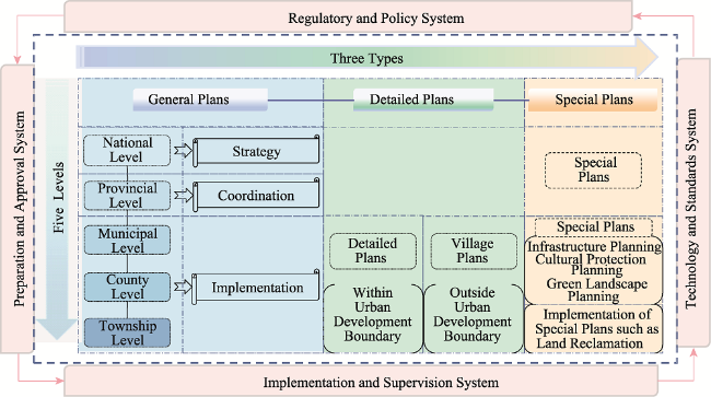
Figure 2 Current spatial planning system of ‘five levels, three types, and four systems’ (Liu and Zhou, 2021)

6 Discussion and conclusions

6.1 Achievements of current LUP

LUP was introduced to China from the Soviet Union in the early 1950s (Zhao et al., 2019). After 70 years of development, China’s LUP has conducted in-depth research and exploration on land-use practices, classification systems, and method evolution and carried out three rounds of general LUP, laying a solid foundation for the reform of China’s TSP in the new era.

6.1.1 Law and regulation system for LUP

The promulgation of the ‘Land Administration Law’ in 1986 for the first time clarified the legal responsibility of governments to compile the general LUP (Zhu, 2013). In 1998, the ‘Land Administration Law’ was revised, and, for the first time, general LUP was listed as a special chapter with legal status (Lichtenberg and Ding, 2008). In 2004, the ‘Land Administration Law’ was amended once more, providing many guiding principles for future adjustments (Dong, 2007). The latest revision in 2019 removed the legal barriers to the entry of collectively owned construction land into the market, improved the land expropriation and rural homestead systems, and reserved legal space for the ‘Multi-plan Coordination’ reform (Lin, et al., 2019). Simultaneously, China has established a relatively complete legal system for LUP. The ‘Regulations on the Implementation of the Land Management Law’ and the ‘Regulations on the Protection of Basic Cultivated Land’ helped perfect the provisions on the compilation and implementation of planning (Dong, 2007). Relevant laws, such as the ‘Environmental Protection Law’ and the ‘Urban Planning Law’, which involved LUP, were also the basis for planning to follow. Additionally, procedural laws such as the ‘Measures for the Examination and Approval of the General Land Use Planning Compilation’ (MLR, 2009), ‘Measures for the Management of Annual Plan for Land Use’ (MLR, 2006), and ‘Measures for the Pre-examination and Management of Land Use for Construction Projects’ (MLR, 2008), made detailed provisions on the management and approval procedures of LUP. Technical specifications, such as the ‘Measures for Land Use Planning Compilation’, provided detailed regulations on the content and technical standards of LUP.

6.1.2 LUP system and classification system

China’s LUP system is relatively complete. In light of the planning period, LUP falls into three categories: long-term, medium-term, and annual LUP (Zong, 2004). At present, a top-down general LUP covering the whole country has taken shape. A special LUP with land development, consolidation, and reclamation plans as its main contents has been implemented in an all-round manner. Detailed LUP in different forms, such as the planning and design of land development and consolidation projects, has also been gradually carried out in depth. Since the establishment of the MNR in 2018, China has been exploring the establishment of a complete TSP system.
It was not until the 1980s that the Land Administration Department promulgated a unified land-use classification (Ma et al., 2018). After several reforms, various departments combined their management need to build a series of land-use classification systems, which gradually formed a relatively complete set of technical norms and implementation management standards. These norms and standards were finally applied to land surveys, LUP, and urban and rural planning (Liu, 2020). The classification system has been gradually improved from single to diversified, and the number of land-use types has increased. The classification content has also changed from focusing only on the function to gradually considering the comprehensive effect of multiple dimensions, such as spatial form and land-use policies (Chai, 2012). Further, classification systems have shifted from non-coordination to gradual cohesion, and their focus has turned from pursuing economic benefits to being people-oriented and paying attention to socioecological benefits.

6.1.3 LUP model and technical methods

Among the three rounds of general LUP implemented in China, the first two rounds adopted the LUP model of indexing and zoning to implement the planning scheme (Yu, 2008). The third round of LUP was repeatedly validated through a preliminary study of the planning all the way to the compilation stage. The rigid and elastic indexes of the LUP were proposed, which were set up by classification. The hierarchical control of the LUP indexes was put into practice, and the spatial control and layout order of various land types were also determined (Dong, 2007). In the first round of general LUP, the ‘Key Points for the Compilation of the General Plans for Land Use at the Provincial Level’ and ‘Key Points for the Compilation of the General Plans for Land Use at the County Level’ were formulated (Zong, 2004). In the second round of general LUP, the ‘Regulations for the Compilation of the General Plans for Land Use at the County Level (Trial)’ was enacted. In the third round, the ‘Technical Guidance for Environmental Impact Assessment of General Land Use Planning at the Provincial Level’, ‘Regulations for the Compilation of the General Plans for Land Use at the Township (Town) Level’, and ‘Technical Guidelines for the Compilation of Village Land Use Planning’ were compiled (Shi, 2009).

6.1.4 Guarantee system for LUP implementation

The LUP implementation process comprehensively uses technical, economic, legal, administrative, and social measures. The introduction of economic incentive, constraint, and guarantee and supervision mechanisms and the adoption of advanced science and technology also promote the implementation of LUP to a certain extent. (Dong, 2007). For example, many places have established a leadership accountability system for LUP implementation and implemented a communal planning announcement system to strengthen target assessment and social supervision of LUP implementation (Xia, 2011). Gradually, a system for the implementation and management of land use with annual LUP, pre-examination of construction land projects, and examination and approval of construction land projects as the main elements was established (Liu et al., 2018). The LUP licencing and approval systems have been gradually legalised, institutionalised, and standardised.

6.2 Existing deficiencies and challenges in LUP

China has always emphasised LUP in regulating land supply and demand, hoping to alleviate the sharp contradiction between non-agricultural construction and the relative shortage of cultivated land. Thus far, China’s LUP has achieved remarkable outcomes in terms of regulatory systems, classification systems, and technical methods, but many problems can still be observed, posing challenges to the reform of territorial space.

6.2.1 Planning legal system construction lags behind and needs to be refined

Owing to the lagging construction of LUP legislation, the legal status and implementation authority of LUP have been underestimated, and a complete LUP legal system has not yet been formed. There is not yet a unified ‘Land Planning Law’ (Liu and Zhou, 2021), and the current laws and regulations on LUP lack operability and have loopholes, leading to a distorted and reversed cohesive relationship between upper- and lower-level planning. In the implementation of LUP, legislation on administrative planning is scattered in individual laws, regulations, and rules, so planning involves administrative subjects with different terms of reference (Gao, 2010). This indicates that the legalisation of the planning implementation is not in place, and illegal land grants and land-use issues remain serious. Random modification and adjustment of plans frequently occurs in certain places as planning still follows leadership and project changes (Dong, 2007). Presently, the legal system related to planning in China is only described in some chapters of the ‘Land Administration Law’ without detailed regulations on LUP. Other laws and regulations are departmental rules with weak legal effect, which leads to a reduction in the scientific character and rationality of LUP and the waste of land resources.

6.2.2 LUP and classification systems need to be further improved

Recently, China’s LUP system has undergone adjustments and changes which involve a passive adaptation and catch-up changes. The lack of a unified planning system in China has led to a poor coordination among planning categories and prominent problems of misplaced, overstepped, and vacant planning (Liu and Zhou, 2021). In terms of classification system, the starting point of classification is department-centred, lacking the unified guidance from the top-level system. The practice and application of each department are carried out only by the department in charge, while the recognition and acceptance of other departments is rather low. Further, the classification system focuses on construction land and agricultural land and pays more attention to the production and living functions of the land-use system, neglecting the overall consideration of ecological land. The current land-use classification is inflexible, and land-use functions are mechanically homogeneous, which can hardly express the composition and compatibility of land-use functions. Various complexes and other multifunctional lands have become a trend, but a classification of composite land under multiple control objectives is missing. In the reform of TSP, it is urgent to construct a unified LUP system and a land-use classification system that is horizontally connected and vertically detailed to coordinate spatial governance and solve the management problems caused by unclear land classification.

6.2.3 Guarantee measures for the implementation of LUP are not yet complete

To a large extent, the implementation of LUP still relies on administrative methods, especially examination and approval, while socioeconomic methods have not been fully employed. The mechanisms of social supervision, administrative disposal, economic sanctions, technical inspection, and regulatory measures for planning implementation and regulation in land-use management are not yet in place. This is reflected in the following aspects. The power of the organisation, examination and approval, implementation, and management are all concentrated in the government. This power is still greater than that of the law. In addition, the use of public supervision and public opinion-based oversight in the implementation of LUP is not sufficient, but effective social restriction mechanisms have not yet been established. Moreover, the current legislative guarantee mostly focuses on the management of all aspects of planning and implementation, and the institutional guarantee of public participation is clearly insufficient (Liu and Zhou, 2021). In the compilation of the TSP in the new era, new legislation and standards need to be expedited to provide the necessary institutional guarantee for its implementation. Effective social control and public participation systems are also needed to monitor the implementation of the planning.

6.3 Future trends

China’s LUP originated from agricultural production activities, evolved around the protection of cultivated land and the control of land use, and will be further developed in the process of establishing a TSP system in the future. From the previous review of the development history of LUP in China, as well as the new requirements for LUP in the new era, the key points of future research are clear. First, by combining the requirements for LUP in the new normal era, the theories and methods of TSP need to be innovated to synthesise land resource allocation and spatial organization. Second, the need for rural revitalisation and the perspective of ecological civilisation construction demand village planning research (Wang J et al., 2020). In a TSP system of ‘five levels and three types’, village planning falls under detailed planning and should be coordinated with other planning (Zhang and Wang, 2018; Yan, 2019).

6.3.1 Innovating theories and technical methods of TSP with Chinese characteristics

With the modernisation of the space governance system, research on the theory and technical methods of TSP has been in high demand (Wang Q R et al., 2020). In the past, most of the studies on LUP focused on theoretical method research and relevant disciplines, both national and international. However, the practice of LUP based on China’s national conditions preceded theoretical research and has formed a planning practice system with strong localisation characteristics. The current new era has new requirements for the establishment of TSP. Accelerating theoretical research, summarising China’s experience, refining its mechanism, and sharing the ‘Chinese story’ to enhance the international influence of China’s TSP are necessary. The key point lies in the methodology. TSP is the ‘integration’ of LUP, urban and rural planning, and other plans. Many theoretical foundations and technical methods can be used for reference and innovation, while at the same time, knowledge from other related disciplines can be used to constantly improve its theoretical and technical method systems.

6.3.2 Accelerating the study of village planning based on the demand of realizing rural revitalization

In the context of TSP and the realisation of rural revitalisation, village planning will inevitably have a new positioning and tasks that are compatible with general LUP. In the TSP system of ‘five levels and three types’, village planning belongs to detailed planning, and the practical village planning of ‘Multi-plan Coordination’ should be formulated in combination with superior planning (Yan, 2019; Zhang and Wang, 2018). There have been an increasing number of village planning theories and practical studies based on the background of TSP. Some of these explore village planning based on a certain policy (Yan, 2019), while others focus on literature review studies in a specific field (Zhang and Wang, 2018). The research perspective includes some hot-spots in TSP and rural revitalisation policies, such as ‘Multi-plan Coordination’ and public participation. Other studies have focused on practical cases (Zhang and Chen, 2018) or planning guidelines (Li et al., 2018) in a certain location. Their results provide valuable information for the study of village planning in the context of TSP and rural revitalisation.

6.3.3 Promoting the construction of a TSP system based on the perspective of ecological civilisation construction

Accelerating the transformation of government functions and establishing a unified spatial planning system based on the reform of the ecological civilisation system have become inevitable. Under such historical conditions, the following questions have become the focus of future research: How can we analyse the scientific basis and institutional conditions of various spatial planning from the perspective of academic research? How can we explore a reasonable spatial planning system organisation, functional positioning, and operating mechanism from the perspective of land rights and regulatory right bundles? How can a spatial planning system be established in the new era from the perspective of ecological civilisation construction and improvement in the protection and supervision of natural resource development (Lin et al., 2019)? How can new fields be expanded while attaching equal importance to deepening traditional fields (Pan et al., 2022)? It is worth mentioning that China’s land development rights system has its own characteristics, which may have defined a new angle to solve the problem of spatial planning coordination. Therefore, strengthening the internal mechanism research and practical framework design of China’s land development right and control systems is expected to be an important research direction to promote the innovation of spatial planning systems.

6.4 Conclusions

By reviewing the LUP practices, classification systems, and method evolution in different periods since the founding of the PRC, this study comprehensively examined the development of LUP in China. Based on this, the achievements, issues to be solved, and future challenges of LUP were summarised. The conclusions of this study are as follows:
(1) After the founding of the PRC, the historical evolution of LUP in China is closely related to socioeconomic development and can be broadly divided into four stages: the planned economy period (1949-1978), the period of transition from the planned economy to a market economy (1978-2000), the initial establishment period of the market economy (2000-2013), and the new normal era (since 2013).
(2) The development of land-use classification in China is slow and can be divided into five stages according to the historical evolution of the land classification system and important events. Before the ROU, the land-use classification system was still in the budding stage, while the formal classification system formation had gone through the exploratory and running-in periods at the early stage of the ROU, the preliminary maturity in the 21st century, and the brand new stage in the new era.
(3) According to the differences in China’s economic system, the development of LUP methods since the founding of the PRC can be divided into two stages, before and after the ROU, using 1978 as a boundary. In the first stage, the planning methods developed slowly and were relatively simple, whereas in the second stage, more diversified technology methods were developed, moving towards modern integrated planning.
(4) During the 40 years of the ROU, China successively conducted three rounds of general LUP under different institutional and policy backgrounds, which represents the process of general LUP from its origin and from formation to maturity.
(5) To date, China’s LUP has made some achievements in the legal system, classification system, technical methods, and guarantee system, but shortcomings and challenges can also be observed. The compilation of TSP in the new era has put forward new requirements in these aspects.
This study provides a theoretical reference for deepening the reform of China’s TSP and accelerating the formation of a reasonable spatial planning system and a sound system for territorial space development and protection.
[1]
Boamah N A, Gyimah C, Nelson J K B, 2012. Challenges to the enforcement of development controls in the Wa municipality. Habitat International, 36(1): 136-142.

DOI

[2]
Cai Y M, Zhang W X, Zhao Y W, 2007. Review on the progress of land use planning in China. Land & Resources, 14-17. (in Chinese)

[3]
Chai M, 2012. Land categorization standards integration for “Two Plans” coordination. Planners, 28: 96-100. (in Chinese)

[4]
Che L, Zhou L, Xu J, 2021. Integrating the ecosystem service in sustainable plateau spatial planning: A case study of the Yarlung Zangbo River Basin. Journal of Geographical Sciences, 31(2): 281-297.

DOI

[5]
Chen K, Long H, Liao L et al., 2020. Land use transitions and urban-rural integrated development: Theoretical framework and China’s evidence. Land Use Policy, 92: 104465.

[6]
Chen W, Ye X, Li J et al., 2019. Analyzing requisition-compensation balance of farmland policy in China through telecoupling: A case study in the middle reaches of Yangtze River Urban Agglomerations. Land Use Policy, 83: 134-146.

DOI

[7]
CPC, 1953a. (Central Committee) Resolution on Mutual Aid and Cooperation in Agricultural Production. http://www.scio.gov.cn/zhzc/6/2/Document/1003287/1003287.htm

[8]
CPC, 1953b. (Central Committee) Instructions on Deep Ploughing and Soil Improvement. http://www.71.cn/2011/0930/632499.shtml

[9]
CPC, 1986a. (Central Committee and State Council) Notice on Strengthening Land Management and Curbing Unlawful Occupation of Cultivated Land. http://f.mnr.gov.cn/201702/t201702061436311.html

[10]
CPC, 1986b. (Central Committee and State Council) Emergency Notice on Strictly Curbing Indiscriminate Occupation and Abuse of Cultivated Land. http://www.sdfymj.com/news/show-96460.html

[11]
CPC, 1997. (Central Committee and State Council) Notice on Further Strengthening Land Management and Effective Protection of Cultivated Land. http://cpc.people.com.cn/GB/64162/71380/71382/71481/4854245.html

[12]
CPC, 2013. (Central Committee) Decision of the Central Committee of the Communist Party of China (CPC) on several Major Issues of Comprehensively Deepening Reform. http://www.gov.cn/jrzg/2013-11/15/content 2528179.htm

[13]
CPC, 2016. (Central Committee and State Council) Opinions on Further Strengthening the Management of Urban Planning and Construction. http://www.gov.cn/zhengce/2016-02/21/content_5044367.htm

[14]
CPC, 2019. (Central Committee and State Council) Opinions on Establishing a Territorial Spatial Planning System and Supervising Its Implementation. http://www.gov.cn/zhengce/2019-05/23/content_5394187.htm

[15]
Dai J, Zhao L X, Huang X F, 1991. SD Model for the development and utilization of land resources in Xinjiang. Transactions of the Chinese Society of Agricultural Engineering, 26-32. (in Chinese)

[16]
Damurski Ł, Oleksy M, 2018. Communicative and participatory paradigm in the European territorial policies. A discourse analysis. European Planning Studies, 26: 1471-1492.

DOI

[17]
Dan C L, Wang Q, 2002. Comparison of land use planning between Western countries and China. China Land Science, (1): 43-46. (in Chinese)

[18]
Deng X, Huang J, Rozelle S et al., 2006. Cultivated land conversion and potential agricultural productivity in China. Land Use Policy, 23: 372-384.

DOI

[19]
Deng X, Huang J, Rozelle S et al., 2015. Impact of urbanization on cultivated land changes in China. Land Use Policy, 45: 1-7.

DOI

[20]
Ding C, 2007. Policy and praxis of land acquisition in China. Land Use Policy, 24: 1-13.

DOI

[21]
Dong Z J, 1997. Some questions about the revision of the general plan for land use. China Land Science, 11: 12-15. (in Chinese)

[22]
Dong Z J, 2007. Study on modern land use planning in China[D]. Nanjing Agricultural University. (in Chinese)

[23]
FAO, 1993. (Food and Agriculture Organization of the United Nations) Land Use Planning. Rome.

[24]
Feng G Q, 1995. A compound model of SD & LP of general plan of land-use. Journal of Guangdong University of Technology, 118-124. (in Chinese)

[25]
Feng Z, Yang Y, Zhang Y et al., 2005. Grain-for-Green policy and its impacts on grain supply in west China. Land Use Policy, 22: 301-312.

DOI

[26]
Fidelis T, Rodrigues C, 2019. The integration of land use and climate change risks in the Programmes of Measures of River Basin Plans: Assessing the influence of the Water Framework Directive in Portugal. Environmental Science & Policy, 100: 158-171.

[27]
Gao X T, 2010. Study on legal system of land use planning[D]. Qingdao: Ocean University of China. (in Chinese)

[28]
Ge D, Lu Y, 2021. A strategy of the rural governance for territorial spatial planning in China. Journal of Geographical Sciences, 31(9): 1349-1364.

DOI

[29]
Gong J, Chen W, Liu Y et al., 2014. The intensity change of urban development land: Implications for the city master plan of Guangzhou, China. Land Use Policy, 40: 91-100.

DOI

[30]
Guo X Y, Liu X L, Wang G, 2015. Land use pattern optimization based on Shuffled Frog Leaping Algorithm. Transactions of the Chinese Society of Agricultural Engineering, 31: 281-288.

[31]
Guo Z, Hu Y, Zheng X, 2020. Evaluating the effectiveness of land use master plans in built-up land management: A case study of the Jinan Municipality, eastern China. Land Use Policy, 91: 104369.

[32]
Hessel R, Berg J V D, Kaboré O et al., 2009. Linking participatory and GIS-based land use planning methods: A case study from Burkina Faso. Land Use Policy, 26: 1162-1172.

DOI

[33]
Kopáček M, 2021. Land-use planning and the public: Is there an optimal degree of civic participation? Land, 10(1): 90.

DOI

[34]
Lai Z H, Chen M Q, Liu T J, 2020. Changes in and prospects for cultivated land use since the reform and opening up in China. Land Use Policy, 97: 104781

[35]
Li B, Wang Z, Chai J et al., 2019. Index system to assess implementation of strategic land use plans in China. Land Use Policy, 88: 104148.

[36]
Li H, Zhou M, Sun X, 2018. Exploration on the method of village planning coverage from the perspective of county planning based on the practice of village planning in Qiyang county based on the guidelines of village planning in Hunan province. Hangzhou: China Urban Planning Annual Conference 2018: 10. (in Chinese)

[37]
Li X, Chen Y, 2019. Projecting the future impacts of China’s cropland balance policy on ecosystem services under the shared socioeconomic pathways. Journal of Cleaner Production, 119489.

[38]
Li Y, Li Y, Westlund H et al., 2015. Urban-rural transformation in relation to cultivated land conversion in China: Implications for optimizing land use and balanced regional development. Land Use Policy, 47: 218-224.

DOI

[39]
Liang X Y, Wu L, Huang H L, 2005. Retrospect and prospect of land (use) planning in New China in 50 years. Journal of Agricultural Science and Technology, 13-16.

[40]
Lichtenberg E, Ding C, 2008. Assessing farmland protection policy in China. Land Use Policy, 25: 59-68.

DOI

[41]
Lin J, Chen X, Wei X, 2011. Coordination problems of spatial planning in China: International lessons and experiences. Modern Urban Research, 26: 15-21. (in Chinese)

[42]
Lin J, Zhao B, Liu S Y, 2019. Urban and rural land use planning evolution in modern China from the perspective of land management. Urban Planning International, 34: 23-30. (in Chinese)

[43]
Lin J, Zhou L, Zhang Y X et al., 2017. Review on the development of land use planning science in recent three decades. China Land Science, 31: 24-33. (in Chinese)

[44]
Liu S Y, 2021. Land is the foundation of the country, and the people are the foundation of the country: The history of the CPC’s promotion of the reform of land system in the past 100 years is clear. Chinese Leadership Science, (2): 26-30. (in Chinese)

[45]
Liu T, 2020. Evolution and prospect of land use classification system in China. Urbanism and Architecture, 17: 38-39. (in Chinese)

[46]
Liu X P, Hu R M, Song Z Q, 2018. The theoretical logic and evolution characteristics of institutional change for pre-examination of construction land use projects in China and its optimized path. China Land Science, 32: 14-20. (in Chinese)

[47]
Liu Y L, Wang H, Ji Y L et al., 2012. Land use zoning at the county level based on a multi-objective particle swarm optimization algorithm: A case study from Yicheng, China. International Journal of Environmental Research and Public Health, 9(8): 2801-2826.

DOI PMID

[48]
Liu Y S, Zhou Y, 2021. Territory spatial planning and national governance system in China. Land Use Policy, 102: 105288.

[49]
Long H, 2014. Land use policy in China: Introduction. Land Use Policy, 40: 1-5.

DOI

[50]
Long H, Li Y, Liu Y et al., 2012. Accelerated restructuring in rural China fueled by ‘increasing vs. decreasing balance’ land-use policy for dealing with hollowed villages. Land Use Policy, 29: 11-22.

DOI

[51]
Long H L, Heilig G K, Wang J et al., 2006. Land use and soil erosion in the upper reaches of the Yangtze River: Some socio-economic considerations on China’s Grain-for-Green Programme. Land Degradation & Development, 17.

[52]
Lord A, Tewdwr-Jones M, 2014. Is planning “Under Attack”? Chronicling the deregulation of urban and environmental planning in England. European Planning Studies, 22(2): 345-361.

DOI

[53]
Lu X H, Ke S G, 2018. Evaluating the effectiveness of sustainable urban land use in China from the perspective of sustainable urbanization. Habitat International, 77: 90-98.

DOI

[54]
MA, 1957. (Ministry of Agriculture) Notice on Helping Agricultural Production Cooperatives in Land Use Planning. http://www.pinlue.com/article/2018/09/1121/597043918043.html

[55]
MA, 1958. (Ministry of Agriculture) Notice on the Implementation of Land Use Planning in People’s Communes. https://www.59baike.com/a/486337-49

[56]
Ma G, 2005. The origin and development of land survey and its relationship with related disciplines. Foshan:2005 Annual Conference of China Land Society. (in Chinese)

[57]
Ma K W, 2000. China Land Resources Survey Technology. Beijing: China Land Press. (in Chinese)

[58]
Ma L, Hao F L, Wang S J, 2018. Land use classification evolution and problems in China since 1949. Resource Development & Market, 34: 617-623. (in Chinese)

[59]
Matthews K B, Buchan K, Sibbald A R et al., 2006. Combining deliberative and computer-based methods for multi-objective land-use planning. Agricultural Systems, 87: 18-37.

DOI

[60]
Meher N N, Khandoker M M, Akira O, 2013. Urban greening using an intelligent multi-objective location modelling with real barriers: Towards a sustainable city planning. Current Urban Studies, (1): 75-86.

[61]
MLR, 1997. (Ministry of Land and Resources) Provisions on the Examination and Approval of the Compilation of the General Land Use Planning. https://www.59baike.com/a/486274-30

[62]
MLR, 2002. (Ministry of Land and Resources) The Notice on Seriously Reinforcing the Plan of Land Consolidation and Land Development. http://www.mohurd.gov.cn/fgjs/xgbwgz/200611/t20061101_159761.html

[63]
MLR, 2005. (Ministry of Land and Resources) Opinions of the Ministry of Land and Resources on the Revision of General Land Use Planning in the Preliminary Stage. http://www.jiangsu.gov.cn/art/2005/9/6/art_65017_346903.html

[64]
MLR, 2006. (Ministry of Land and Resources) Measures for the Management of Annual Plan for Land Use. http://www.gov.cn/ziliao/flfg/2006-12/25/content_477669.htm

[65]
MLR, 2007. (Ministry of Land and Resources) Classification Standards for Land Use Status. https://www.sohu.com/a/216975920_188910

[66]
MLR, 2008. (Ministry of Land and Resources) Measures for the Pre-examination and Management of Land Use for Construction Projects. http://www.gov.cn/flfg/2008-12/03/content_1166658.htm

[67]
MLR, 2009. (Ministry of Land and Resources) Measures for the Examination and Approval of the General Land Use Planning Compilation. http://www.gov.cn/gzdt/2009-02/11/content_1227538.htm

[68]
MLR, 2011. (Ministry of Land and Resources) Outline of the National Land Planning (2011-2030). http://www.gov.cn/gzdt/2012-12/21/content_2295589.htm

[69]
MNR, 2019a. (Ministry of Natural Resources) Guidelines on Zoning and Use Classification of Urban and County Terrestrial Spatial Planning. https://www.ciyew.com/policy/5531-4680.html

[70]
MNR, 2019b. (Ministry of Natural Resources) Notice on Comprehensively Carrying out Territorial Spatial Planning Work. http://www.gov.cn/xinwen/2019-06/02/content_5396857.htm

[71]
MNR, 2020a. (Ministry of Natural Resources) Guidelines for the Evaluation of the Carrying Capacity of the Resource Environment and the Suitability of Territorial Space Development” (Trial). http://gi.mnr.gov.cn/202001/t20200121_2498502.html

[72]
MNR, 2020b. (Ministry of Natural Resources) Guidelines for the General Plan for Territorial Spatial Planning at Municipal and County Levels. http://gi.mnr.gov.cn/202009/t20200924_2561550.html

[73]
MNR, 2020c. (Ministry of Natural Resources) Guidelines of Provincial-level Territorial Spatial Planning” (Trial). http://gi.mnr.gov.cn/202001/t20200120_2498397.html

[74]
MNR, 2020d. (Ministry of Natural Resources) Notice on Strengthening the Supervision and Administration of Territorial Spatial Planning. http://gi.mnr.gov.cn/202005/t20200526_2521189.html

[75]
NDRC, 2014. (The National Development and Reform Commission) Notice on Launching the Pilot Project of ‘Multi-plan Coordination’ in Cities and Counties. http://www.zgsxzs.com/a/20141217/663531.html

[76]
Ni Y L, Liu F H, 1991. Investigation and research on land quota index of township enterprises in Heilongjiang Province. China Land Science, 5: 39-40. (in Chinese)

[77]
Niu S D, Fang B, 2019. Cultivated land protection system in China from 1949 to 2019: Historical evolution, realistic origin exploration and path optimization. China Land Science, 33(10): 1-12. (in Chinese)

[78]
Pan S P, Chen W X, Liang J L et al., 2023. Comparison of spatial planning research at home and abroad based on bibliometric analysis. Chinese Journal of Agricultural Resources and Regional Planning, 44(2): 131-144. (in Chinese)

[79]
Pena S B, Abreu M M, Magalhaes M et al., 2020. Water erosion aspects of land degradation neutrality to landscape planning tools at national scale. Geoderma, 363: 114093.

[80]
Ping L, Yu M, Hu Y, 2020. Contradictions in and improvements to urban and rural residents’ housing rights in China’s urbanization process. Habitat International, 97: 102101.

[81]
Qiang H, Wei S, 2019. A land-use spatial optimum allocation model coupling a multi-agent system with the shuffled frog leaping algorithm. Computers, Environment and Urban Systems, 77.

[82]
Qu F T, Ma X L, Guo G C, 2021. Institutional logic and major contribution of centennial land policy to political order, economic development and national governance. Management World, 37(12): 1-15. (in Chinese)

[83]
SC, 1987. (State Council) Notice on Carrying out the General Planning for Land Use. https://law.lawtime.cn/d594666599760.html

[84]
SC, 1999. (State Council) Outline of the National General Plan for Land Use (1997-2010). http://www.mnr.gov.cn/gk/ghjh/201811/t20181101_2324581.html

[85]
SC, 2004. (State Council) Decision of the State Council on Deepening Reform and Strict Land Administration. http://www.gov.cn/zhengce/content/2008-03/28/content_2457.htm

[86]
SC, 2008. (State Council) Outline of the General Plan for National Land Use (2006-2020) http://www.gov.cn/zxft/ft149/content_1144625.htm

[87]
Shen X, Wang X, Zhang Z et al., 2019. Evaluating the effectiveness of land use plans in containing urban expansion: An integrated view. Land Use Policy, 80: 205-213.

DOI

[88]
Shen Y C, 2010. Studies on land types: Academic significance, function and prospect. Geographical Research, 575-583. (in Chinese)

[89]
Shi J W, 2009. Study on changes and evolution of comprehensive land use planning. Guangdong Land Science, 8: 4-8. (in Chinese)

[90]
Shi W J, 2005. Construction of land use planning system in China. China Land Science, 3-9. (in Chinese)

[91]
Siiba A, Adams E A, Cobbinah P B, 2018. Chieftaincy and sustainable urban land use planning in Yendi, Ghana: Towards congruence. Cities, 73: 96-105.

DOI

[92]
Song W, Pijanowski B C, Tayyebi A, 2015. Urban expansion and its consumption of high-quality farmland in Beijing, China. Ecological Indicators, 54: 60-70.

DOI

[93]
Sun S W, 2016. The discipline of urban and rural planning in China: History and prospect. City Planning Review, 40: 106-112. (in Chinese)

[94]
Tao Z H, Fan S Y, 2000. Reflections on the scientificity and operability of the general plan for land use. China Land Science, 14: 23-26. (in Chinese)

[95]
Tong X H, 1997. Methods and applications of population prediction in land planning: A case study of Yulin city. Journal of Nanning Normal University (Natural Science Edition), 20-25. (in Chinese)

[96]
Wang B, Gao P, Niu X et al., 2017. Policy-driven China’s Grain to Green program: Implications for ecosystem services. Ecosystem Services, 27: 38-47.

DOI

[97]
Wang D W, Li F X, Chen D, 2019. Research on optimal land use allocation based on Pareto optimal and multi-particle swarm algorithm. Resources and Environment in the Yangtze Basin, 28. (in Chinese)

[98]
Wang J, Chen Y, Shao X et al., 2012. Land-use changes and policy dimension driving forces in China: Present, trend and future. Land Use Policy, 29: 737-749.

DOI

[99]
Wang J, Wu Q, Yan S et al., 2020. China’s local governments breaking the land use planning quota: A strategic interaction perspective. Land Use Policy, 92: 104434.

[100]
Wang K, Hou L, 2013. China’s urban planning experience in the 1960s interview with Academician Zou Deci. Urban Planning Forum, 127-129. (in Chinese)

[101]
Wang K, Zhang J, Xu Z et al.,2012. Coordinative and transition-oriented technical regulations for land use planning: An analysis on the code for classification of urban land use and planning standards of development land (GB 50137-2011). City Planning Review, 36: 42-48. (in Chinese)

[102]
Wang Q R, Lang H O, Zhong J X et al., 2020. Progress review on land science research in 2019 and prospects for 2020. China Land Science, 34: 79-91. (in Chinese)

[103]
Wang W M, 2000. Land Use Planning. Beijing: China Land Press. (in Chinese)

[104]
Wang W M, 2003. Science of Land Resource Management. Beijing: Higher Education Press. (in Chinese)

[105]
Wang X G, Wang B, 1994. The application of multi-objective decision in land use planning. Research of Agricultural Modernization, 225-228. (in Chinese)

[106]
Wu C F, Ye Y M, 2000. Development of international land use planning in the 20th century and its prospect in the new century. China Land Science, (1): 15-20. (in Chinese)

[107]
Wu F, 2015. Planning for Growth: Urban and Regional Planning in China. London: Routledge.

[108]
Wu Y, Shan L, Guo Z et al., 2017. Cultivated land protection policies in China facing 2030: Dynamic balance system versus basic farmland zoning. Habitat International, 69: 126-138.

DOI

[109]
Xia C Y, 2011. A study on evaluation and indemnification of the implementation of land use planning[D]. Nanjing Agricultural University. (in Chinese)

[110]
Xu G, Dong T, Cobbinah P B et al., 2019. Urban expansion and form changes across African cities with a global outlook: Spatiotemporal analysis of urban land densities. Journal of Cleaner Production, 224: 802-810.

DOI

[111]
Yan J, Zhang D, Xia F, 2021. Evaluation of village land use planning risks in green concepts: The case of Qiwangfen Village in Beijing. Land Use Policy, 104: 105386.

[112]
Yan J M, Guo D L, Xia F Z, 2021. The historical logic, theoretical logic and practical logic of the change of the land system of the Communist Party of China in the past 100 years. Management World, 37(7): 19-31. (in Chinese)

[113]
Yan L, 2019. Research on the rural revitalization planning in the perspective of the integration of knowledge and practice. Development of Small Cities & Towns, 37: 74-81. (in Chinese)

[114]
Yang C C, Tsung T K, 2014. An interactive dynamic multi-objective programming model to support better land use planning. Land Use Policy, 36: 13-22.

DOI

[115]
Yang C J, Ma H Y, 2013. An AHP-based fuzzy approach to performance evaluation of new socialist countryside in northwest minority regions of China. Applied Mechanics & Materials, 263-266: 3306-3311.

[116]
Ye X Y, Dennis W Y H, 2005. Geospatial analysis of regional development in China: The case of Zhejiang Province and the Wenzhou Model. Eurasian Geography and Economics, 46(6): 445-464

DOI

[117]
Yi J, Zhang T C, Zhao S Q et al., 1997. Discussion on the multi-objective planning model of land use planning. Geography and Geo-Information Science, 42-46. (in Chinese)

[118]
Yu Z X, 2008. On the problems existing in the third-round land overall use planning in China. Journal of Anhui Agricultural University (Social Sciences Edition), 17: 39-43, 117. (in Chinese)

[119]
Zhai W X, Huang X J, 2003. Analysis on the effect of policies operation of cultivated land protection in China. China Land Science, 17(2): 8-13 (in Chinese)

[120]
Zhang G Y, Liu Y Q, 1997. Systematic thinking of land use problem. China Land, 15-17. (in Chinese)

[121]
Zhang H Q, Xu E Q, Zhu Y H, 2015. An ecological-living-industrial land classification system and its spatial distribution in China. Resources Science, 37: 1332-1338. (in Chinese)

[122]
Zhang J X, 2013. The Current Trend of Urban and Rural Planning in China. Nanjing: Southeast University Press. (in Chinese)

[123]
Zhang X, Wang N, 2018. Establishing context dependent rural planning: Reviewing the diversity and differentiation of literature. Urban Development Studies, 25: 70-76. (in Chinese)

[124]
Zhang Z J, Chen M, 2018. Exploration of Beijing village planning transition under the background of rural revitalization strategy. Shanghai Urban Planning Review, 58-62. (in Chinese)

[125]
Zhao B, Lin J, Liu S Y, 2009. Analysis of evolution of urban and rural land use planning system in modern China from the perspective of ingestion and originality. Urban Planning International, 34: 31-36. (in Chinese)

[126]
Zhao X M, Wang R C, Wu C F, 1996. System dynamics imitation of land use planning: Exemplified by integrated land use planning in Hangzhou city. Journal of Zhejiang Agricultural University, 143-148. (in Chinese)

[127]
Zheng W Y, 2000. Land use planning at the turn of the century: Review and prospect. China Land Science, 14: 2-5. (in Chinese)

[128]
Zhou L, Sun Q, Guo X L, 2019. Research on the classification system of land use for land planning of ‘Five Levels and Three Types’. China Urban Planning Annual Conference 2019, Chongqing, China, 12. (in Chinese)

[129]
Zhou Y, Huang X, Chen Y et al., 2017. The effect of land use planning (2006-2020) on construction land growth in China. Cities, 68: 37-47.

DOI

[130]
Zhou Y X, Zhang J L, Tang Z B, 2020. The formation, conflicts and prospect of the planning system in China: The perspective of the territorial spatial planning. Urban Planning Forum, 27-34. (in Chinese)

[131]
Zhu J, Pawson H, Han H et al., 2022. How can spatial planning influence housing market dynamics in a pro-growth planning regime? A case study of Shanghai. Land Use Policy, 116: 106066.

[132]
Zhu S M, 2013. Research on the legal construction of land management in China. Modern Business Trade Industry, 25: 26-27.

[133]
Zong R, 2004. Study on the structure of the land use planning system of China[D]. Nanjing: Nanjing Agricultural University. (in Chinese)

[134]
Zysk E, Dawidowicz A, Zróbek S et al., 2020. The concept of a geographic information system for the identification of degraded urban areas as a part of the land administration system: A Polish case study. Cities, 96: 102423.

Outlines

/