Research Articles

Critical threshold of periodic point bar scour and sediment body transport path in tidal reaches: A case study of Fujiangsha reach, Yangtze River

  • WANG Jianjun , 1 ,
  • YANG Yunping , 2, * ,
  • ZHANG Mingjin 2 ,
  • ZHU Lingling 3 ,
  • LI Shaowu 1 ,
  • WEN Yuncheng 4
Expand
  • 1. State Key Laboratory of Hydraulic Engineering Simulation and Safety, Tianjin University, Tianjin 300072, China
  • 2. Key Laboratory of Engineering Sediment, Tianjin Research Institute for Water Transport Engineering, Ministry of Transport, Tianjin 300456, China
  • 3. Bureau of Hydrology Changjiang Water Resources Commission, Wuhan 430010, China
  • 4. Nanjing Hydraulic Research Institute of Ministry of Water Resources, Ministry of Transport, National Energy Administration, Nanjing 210024, China
*Yang Yunping (1985-), Associate Professor, E-mail:

Wang Jianjun (1980-), PhD and Associate Professor, E-mail:

Received date: 2022-06-01

  Accepted date: 2022-11-03

  Online published: 2023-06-26

Supported by

National Key Research and Development Program of China(2021YFB2600500)

National Natural Science Foundation of China(52279066)

Jiangsu Water Conservancy Science and Technology Project(2020001)

Abstract

The evolution of point bars in changing sections of a downstream tidal current limit is periodic. Accordingly, assessing the critical morphology and hydrodynamic characteristics of point bar scour and the sediment transport process of scour sediment bodies can support river regulation and waterway maintenance. The frequent scour of point bars in changing sections of tidal current limits within the Yangtze River directly restricts waterway stability. This study examined the Fujiangsha reach of the Yangtze River, hydrological data on sediment transport, and riverbed topography from 1950. The Jingjiang bank tail exhibited an evolutionary cycle (siltation>scour>siltation), with a primary period ranging from 3-6 years. Additionally, certain morphological and dynamic conditions were necessary for scour. The Datong station flow (Q) ranged from 20,000-40,000 m3·s-1 for ≥180 days·yr-1, enabling the bank silt layers to widen. Scour occurred during flooding and was concentrated in areas 5.0-7.5 km downstream from Ebizui. When Q≥40,000 m3·s-1, scouring occurred in the bank middle and lower reaches, whereas Q≥50,000 m3·s-1 for >50 consecutive days, scour occurred at the tail as well. Moreover, the volume of the scour shoals increased with the number of high-flow days (≥60,000 m3·s-1). Bottom sand transport mainly occurred in the low-bank zone. Before the project’s second phase, the longitudinal transport of the scouring sand bodies occurred as follows: Jingjiang bank > low bank on the north side of Shuangjiansha > Fubei anabranch. During the second phase, the longitudinal transport route changed to Jingjiang bank > Fubei anabranch. The Jingjiang bank volume was also reduced; thus, its development was controlled. Owing to changes in the longitudinal transport routes, dredging should be conducted in areas where scouring sand bodies are separately transported from the tail, thereby reducing the load of dredging and maintenance for the Fubei anabranch during dry years.

Cite this article

WANG Jianjun , YANG Yunping , ZHANG Mingjin , ZHU Lingling , LI Shaowu , WEN Yuncheng . Critical threshold of periodic point bar scour and sediment body transport path in tidal reaches: A case study of Fujiangsha reach, Yangtze River[J]. Journal of Geographical Sciences, 2023 , 33(6) : 1334 -1358 . DOI: 10.1007/s11442-023-2132-8

1 Introduction

In recent decades, flow characteristics, sedimentation, and geomorphology have deviated from natural patterns to complex processes dominated by anthropogenic effects, such as climate change (Dalrymple and Choi, 2007; Zhou et al., 2017; Wang et al., 2018). Thus, developing measures to cope with and adapt to such artificial changes is of significant interest to researchers and government project managers. Socio-economic activities in river basins influence water quality and sediment transport, as well as the evolution of banks and channels that affect the characteristic patterns of river geomorphology in the quasi-natural state (Guo et al., 2019, 2021b; Zhou et al., 2020, 2021). Recently, climate change and human activities have had a profound impact on the sediment loads and channel morphology of the Yangtze River in China (Li et al., 2018, 2019; Guo et al., 2019; Zhou et al., 2021). Waterway engineering construction and dredging excavation have changed the shape of the natural shoals and troughs in the estuary delta (Dai et al., 2013; Wei et al., 2017). The Nanjing-Liuhekou reach in the lower reaches of the Yangtze River comprises tidal current boundary-changing regions (Yang et al., 2012) and the resulting bank evolutionary patterning. To completely utilize deep-water resources, first- and second-phase projects related to the deep waterway (depth, 12.5 m) have been implemented. The Fujiangsha reach is the key navigation-obstructing section of the Nanjing-Liuhekou reach. As the periodic evolution mechanisms of the Jingjiang bank have not been comprehensively evaluated, no control measures have been adopted during the second-phase project (Wang et al., 2020; Yang et al., 2021b). Additionally, the periodic evolution of siltation and scouring in the Jingjiang bank is a key factor in navigation obstruction.
Since the Three Gorges Project began operations in 2003, the tidal reach of the Yangtze River has exhibited an increasingly rapid change from siltation to scouring (Mei et al., 2021; Xie et al., 2021). Accordingly, from 2008 to 2013, the tidal reach of the Yangtze River was silted up, and the maximum silting zone moved towards the basin by 100 km (compared to the 1992-2002 position), with the high flood season discharge and strong fluctuation of water levels caused by tidal forces being the primary controlling factors (Mei et al., 2021). In recent years, the tidal power in the Datong-Nanjing reach has been increasing, and in junction with the increased tidal power outside of the estuary and sea level rise, the resulting tide tracing has also increased (Yuan et al., 2019). Influenced largely by human activity, considerable changes nave in hydrodynamic forces, riverbed scouring, and silting intensity have occurred in the tidal reach of the Yangtze River. Notably, the Fujiangsha reach, where the Jingjiang bank is located, is situated in the changing section of the Yangtze River tidal current boundary. The bank has shown a river regime pattern of “second-order branch, and three channels and two shoals,” and the intricate hydrodynamic forces along with active sediment transport within the branch channels further increase the complexity of the evolution of the bank.
For reaches where runoff control measures are in place, the degree of navigation obstruction is significantly higher in multibranch reaches than in single reaches. Thus, waterway maintenance is arduous for the Shashi, Tianxingzhou, Dongliu, and Jiangxinzhou reaches in the dry season. Furthermore, a waxing and waning cycle links Taipingkou, Sanbatan, and Lalinzhou banks in the Shashi reach (Zhu et al., 2011; Wang et al., 2015; Zhang et al., 2016; Yang, 2020; Yang et al., 2021a, 2023a), with the latter playing the leading role in the evolution of bank groups (Wang et al., 2015; Jia et al., 2017). For example, the evolution of the Hankou bank in the upper reaches of the Tianxingzhou reach is characterized by a slow downstream shift, followed by a sudden upward shift on a 5-6 year cycle, where the scouring and silting of the low bank at the inlet of the branch channel exhibits a periodic response (Sun et al., 2013). Regarding the processes of head scouring, tail silting, and downstream shifting of the bank on the left bank of the Dongliu reach, the branch channels of the east and west ports mutually alternate, and the waterway conditions are extremely unstable (Liu et al., 2020). Tail silting and downstream extending at the Niutunhe bank in the Jiangxinzhou reach causes the shoreline on the left edge of Jiangxinzhou to retreat because of scouring. The head of the upper and lower Hejiazhou bank as well; thus, waterway conditions have deteriorated (Liu et al., 2020). Generally, morphology and position changes in channels and banks determine the waterway conditions of upstream and downstream shifting. The wide siltation and downstream extension of the Sanyiqiao (Yang et al., 2020) and Gaogang banks (Ying et al., 2020) in the boundary-changing regions during the dry season result in the deep waterways (depth, 12.5 m) of the Luochengzhou and Manyusha reaches, often appearing as shallow obstructions.
The Fujiangsha reach is located in the changing section of the tidal current boundary during the flood season (Yang et al., 2012), with the Jingjiang bank located on the left bank of the inlet. Banks (e.g., Fujiangsha, Shuangjiansha, and Changqingsha) are present downstream. Furthermore, the mobility of the Jingjiang bank directly affects the stability of downstream branches and waterway conditions for the Fubei anabranch (Jiang et al., 2011; Yang et al., 2013; Xu et al., 2014; Chen et al., 2016); this influence is hysteretic (Xu et al., 2014). Following the construction of the Three Gorges Project, the influence of the Jiangyin reach river regime evolution on the Fujiangsha reach has been gradually weakening, where the silting rate of the Jingjiang bank has decreased after scouring, thereby lengthening the evolution period (Wen et al., 2018). The primary influencing factors of scouring and deposition evolution in the transition section of the Jingjiang bank include the intra-annual mainstream winds in the upper bend, abundant upstream sediment sources during the flooding season, and downstream water diversion of the Fujiangsha reach (Shen et al., 2020). Following the implementation of the second phase of the project, the water depth conditions of the Fujiangsha reach were improved (Zhang et al., 2017). However, it remains necessary to consider the influence of the sediment activity in the Jingjiang bank on the back siltation of the Fubei anabranch (Qu and Ma, 2019; Wang et al., 2020). Passing sediment is formed when the scouring and bodies of the Jingjiang bank shift down (Zhang et al., 2017). As the volume of the scouring sand bodies increases, the dredging and maintenance volume of the Fubei anabranch increases (Wang et al., 2020). In summary, existing research has focused on the bank-channel evolution and waterway maintenance of the Fujiangsha reach, concentrating on the intra-annual and periodic evolution characteristics of the Jingjiang bank in particular. The controlling mechanisms of bank evolution with respect to waterway conditions and dredging maintenance of the Fubei anabranch have also been investigated. Owing to the periodic characteristics of the Jingjiang bank evolution, the critical morphological characteristics of bank body scour, as well as the relationships between the critical flow level of scouring, the number of days of characteristic flow level of previous silting width, and the longitudinal transport mechanism of the scouring body remain to be revealed.
In the present study, hydrology, sediment, and riverbed topography data in the Fujiangsha reach were collected for the period 1950-2019. Based on analyses of the intra- and inter-annual evolutionary processes, as well as the volume changes of the Jingjiang bank, the scouring critical morphology and critical flow level characteristics were identified. Furthermore, the relationships between tail scouring and the number of days of previous siltation characteristic flow levels were clarified. The relationship governing the distribution between suspended sediment and that deposited on the riverbed of the Fujiangsha reach were analyzed before and after the second phase of the project, and the vertical transport mechanism of scouring sand bodies at the Jingjiang bank were clarified as well.

2 Research area and materials

2.1 Research areas

The plane morphology of the Fujiangsha reach displays a pattern of “second-order branch, and three channels and two shoals.” The primary branch is divided into the Funan and Fuzuo anabranches via the Fujiangsha, whereas the secondary branches are divided into the Fuzhong and Fubei anabranches by the Shuangjiansha and Minzhusha (Figure 1). The Shuangjiansha Guard project (head submerged dike, north and south longitudinal dikes) was implemented during 2009-2011. From 2015-2017, the second phase of the deep waterway downstream of Nanjing (depth, 12.5 m, referred to hereafter as the “second-phase project”) was implemented, which included four spur dikes on the left edge of the Fujiangsha bank body, as well as the Shuangjiansha head submerged and spur dikes based on the Shuangjiansha Guard project. In total, the Shuangjiansha project contained a head submerged dike, four spur dikes on the north side of the submerged dike, three spur dikes on the south side, and five spur dikes on the south side of the Shuangjiansha south longitudinal dike.
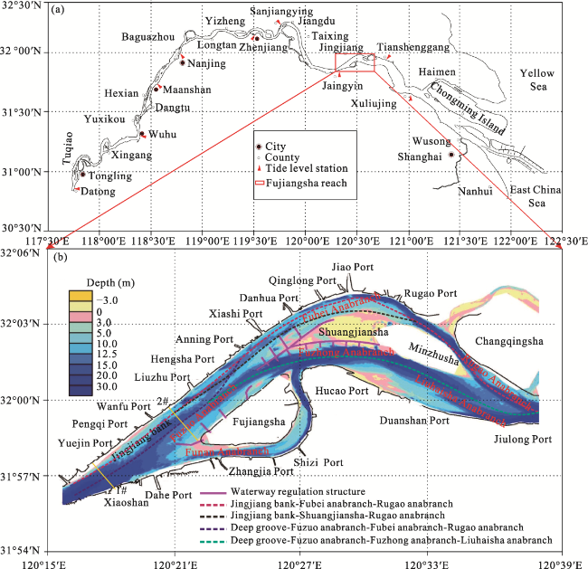
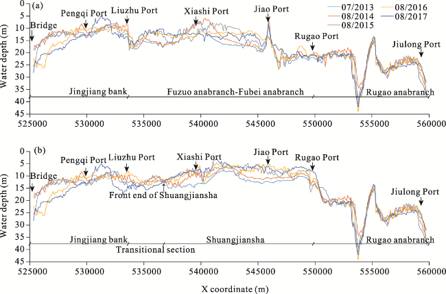
Figure 1 Reach locations and characteristic cross-sections of the Fujiangsha reach, Yangtze River: (a) Research used for research; (b) Profile of the reach (in August 2016)

2.2 Research materials

The average daily, monthly, and interannual flow data of the Datong Station from 1950 to 2019 were collected to assess changes in inflow patterns and days with characteristic flow levels in the basin. The topographic data of the Fujiangsha reach measured from 1959 to 2019 were collected to analyze the evolution of the Jingjiang bank using Civil 3D v23.2. The topographic data were measured at a scale of 1:10,000, and the scale around the waterway improvement buildings was 1:2000. The corresponding volume of the 10.0-m and 12.5-m isobaths, and the river channel capacity of the Fubei anabranch using Civil 3D v23.2. Hydrological and sediment data from 2012 to 2018 were collected to analyze variations in the split and sediment diversion ratios, as well as the sediment transport intensity along the river bottom. A further summary of the data types and sources can be found in Table 1.
Table 1 Data types and sources
Data type Time span Data characteristics Data sources
Hydrology 1950-2019 Daily, monthly, and annual average flows Hydrology Bureau of Changjiang Water Resources Commission, Changjiang Waterway Bureau, Nanjing Deep Waterway Engineering Construction Headquarters, Nanjing Hydraulic Research Institute
Runoff and sediment 1967-2018 Split ratio of branches (1967-2018), sediment diversion ratio of branches (2012-2018), and sediment measurement data of the entire reach (Feb, Aug 2016)
Riverbed topography 1959-2019 10.0 m isobaths (1959-2002), and measured water depth scatterplots (2004-2019, scale 1:10,000)

2.3 Research methodology

The volume of the Jingjiang bank was divided into two parts: 10.0 m and 12.5 m. The upper boundary was bordered by the Jiangyin Yangtze River Bridge; the downstream end of the 10.0-m and 12.5-m isobaths and the Yangtze River embankment served as the boundary of the left bank.
The volumes of the bank and deep channel are calculated using the grid method as follows. A triangular grid is used to dissect the computational domain, and the grid density is the same as the density of the measured terrain scatter points to ensure the consistency of the calculation results with the measured results. After dissection, each triangular cell forms a wedge, and the cross-sections of the isobaths at different depths and the bank are the straight sections of the wedge. According to the calculation formula of the wedge volume:
(1) Case 1: Internal grid of the computational domain
V i n = i = 1 m 1 3 ( h i 1 + h i 2 + h i 3 ) S i
where Vin is the volume of the triangular cells inside the computational domain; m is the total number of cells inside the computational domain; hi1, hi2, and hi3, are the distances from the cross-section to the riverbed at the grid nodes, respectively; and Si is the area of the triangular cells.
(2) Case 2: Boundary grid of the computational domain
Quadrilateral (hj4 = 0, hj5 = 0)
V o u t - q u a = j = 1 n 1 3 ( h j 2 + h j 4 + h j 5 ) g S j 1 + j = 1 n 1 3 ( h j 2 + h j 3 + h j 5 ) g S j 2 = j = 1 n 1 3 ( h j 2 ) g S j 1 + j = 1 n 1 3 ( h j 2 + h j 3 ) g S j 2
where Vout-qua is the volume of the quadrilateral cells at the boundary of the computational domain; n is the total number of quadrilateral cells at the boundary of the computational domain; hj2 and hj3 are the distances from the cross-section to the riverbed at the grid nodes at the boundary of the computational domain, respectively; and Sj = Sj1 + Sj2 and Sj are the areas of the shaded quadrilateral in the boundary cells of the computational domain.
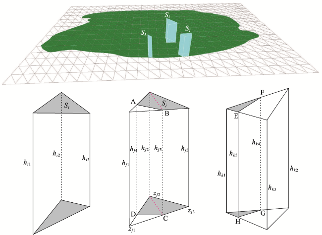
Figure 2 Calculation of the volume of the bank and river channel

3 Research processes and results

3.1 Interannual evolution process of the Jingjiang bank

Assessing the inter-annual changes at the Jingjiang bank revealed that the bank body maintains distinct scour characteristics; it was also divided by the implementation nodes of the waterway regulation project. Accordingly, the changes in morphology and scouring body of the Jingjiang bank before and after project implementation were studied.

3.1.1 Interannual variation and scour mode

Over the long-term, the evolution of the Jingjiang bank displays clear periodicity, mainly characterized by a “silting up-scouring-silting up again” process at the tail (Figure 3). From 1970 to 1999, the tail of the Jingjiang bank was located in the Pengqi Port-Liuzhu Port region. In 1970, the separated bodies appeared at the tail of the Jingjiang bank due to the scour, and shoals appeared near the downstream Liuzhu Port region. Since 1999, the tail of the Jingjiang bank has been moving from Wanfu to Liuzhu ports, while the maximum width of the 10.0-m isobath has been located in regions ranging from Yuejin to Wanfu ports.
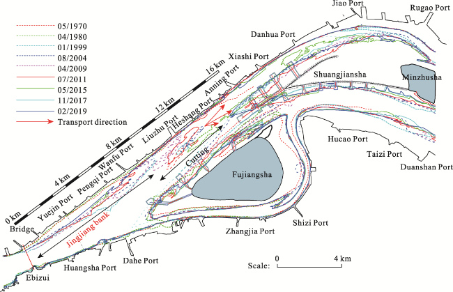
Figure 3 Changes in the 10.0-m isobath of the Jingjiang bank

3.1.2 Volume changes of the Jingjiang bank

Since completing the project’s second phase, the Jingjiang bank volume has generally decreased (Figure 4a). The volumes of the 10.0-m and 12.5-m isobath banks were 12.8% and 22.7%, respectively, in February 2019 compared to August 2015. During the flood season, the volume of the Jingjiang bank first slightly increased before decreasing. For example, the volume of the Jingjiang bank increased in August 2016 and August 2017 compared to July 2013, August 2014, and August 2015. In contrast, the volumes of 10.0-m and 12.5-m isobaths decreased by 22.3% and 22.8%, respectively, in August 2018 compared to August 2017 (Figure 4b). Alternatively, the dry season volume of Jingjiang bank always decreased. Compared with data from February 2016, the volume of the 10.0-m and 12.5-m isobaths in February 2019 had decreased by 17.2% and 25.1%, respectively (Figure 4c).
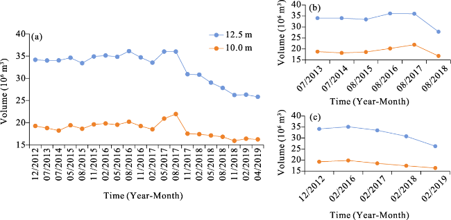
Figure 4 Changes in the 10.0-m isobath volume of the Jingjiang bank: (a) Volume of the bank during 2012-2019; (b) Flood season; (c) Dry season

3.2 Morphological change characteristics of the Jingjiang bank

Eight sets of water depth maps from 1999 to 2012 and eight additional maps from 2016 to 2017 (recorded in February, May, August, and November) were used to analyze the evolutionary processes of the Jingjiang bank in its natural state and once subjected to the influence of the project’s second phase, respectively.

3.2.1 Natural state evolutionary processes

In January 1999, the shape of the 10.0-m isobath in the Jingjiang bank was relatively complete, with a maximum width of 1999 m recorded 6770 m downstream of Ebizui (Jiangyin Yangtze River Bridge; Figure 5a). In 2002, the tail of the 10.0-m isobath bank of the Jingjiang bank was cut, and a 1.12 km2 sized scouring body was formed. The water depth map in August 2004 indicated that the shoals formed during the October 2002 tail scour had gradually shifted down, leading to a 0.25 km2 decrease in area. Comparatively, in 2009, the shape of the 10.0-m isobath of the Jingjiang bank was also relatively complete (Figure 5b), with a maximum width of 1190 m located 6200 m downstream of Ebizui. Water depth mapping in August 2010 revealed that the tail of the Jingjiang bank was cut, resulting in a scouring body with an area of 1.67 km2. By December 2012, the scouring body gradually shifted down and merged with the left edge of the low bank at the head of Shuangjiansha.
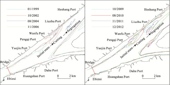
Figure 5 Changes in the 10.0-m isobath of the Jingjiang bank from 1999-2012

3.2.2 Evolutionary processes post-waterway engineering

From February to May 2016, the 10.0-m isobath in the upper-mid reach of the Jingjiang bank was relatively stable (Figure 6a), while tail silting occurred downstream. From May to August 2016, the Jingjiang bank was silted wide, with the tail being cut to a certain extent and a scour area of 0.22 km2. From August to November 2016, the 10.0-m isobath of the Jingjiang bank was characterized by the middle part of the bank, which exhibited head scouring and tail silting characteristics, whereas the tail shoals continued to shift downstream. From February to May 2017, the middle reach of the Jingjiang bank exhibited head-scouring and tail-silting characteristics, and in 2016, the scouring sand bodies at the tail continued to shift downstream (area, 0.17 km2; Figure 6b). From May to August 2017, the middle reach of the Jingjiang bank was in a head scouring and tail silting state, with the area of the scouring sand bodies at the tail reaching only 0.04 km2. Thus, the scouring sand bodies may have entered the Fubei anabranch and were transported downstream. From August to November 2017, the Jingjiang bank was scoured in the middle reach and silted at the tail, with sporadic sand bodies (water depth <10.0 m) appearing in the inlet area of the Fuzuo-Fubei anabranch.
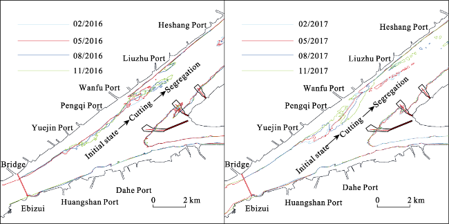
Figure 6 Changes in the 10.0-m isobaths of the Jingjiang bank in 2016 and 2017
The observed scour process at the tail of the Jingjiang bank suggested the tail was cut during flood years. Prior to scouring, the bank body corresponding to a water depth <10.0 m was wider, with a maximum width >1000 m. The scour area increased as the position of the maximum width approached that observed upstream. Since the implementation of the second phase of the project in 2016—a notable flood year, the annual runoff at the Datong Station was closer to that of 2010, and the resulting area of scouring sand bodies at the tail of the Jingjiang bank decreased by 86.8% due to the squeezing water which flowed to the left bank side after the launch of the waterway engineering project on the left edge of the Fujiangsha reach.

3.3 Scour mode and bank body critical morphology

Since the Three Gorges Project began operation in 2003, tidal currents have been active in the Luochengzhou reach, achieving flow levels of 26,000-34,000 m3·s-1 (Yang et al., 2020). Notably, the degree of navigation obstruction in 2017—a moderately low-water year with a long duration—was greater than seen in the known flood year of 2016 (Yang et al., 2020). The Jingjiang bank at the Fujiangsha waterway was characterized by periodic siltation-scour, with a scouring flow rate of 38,700-54,100 m3·s-1 recorded during the ebb tide in the flood season, and 11,800-23,700 m3·s-1 during the flood tide of the dry season (Du et al., 2021). The critical flood season average runoff caused by the shift in tidal forces on the Tianshenggang-Xuliujing reach from siltation to scouring promotion was 36,000 m3·s-1—identical to the critical flow causing tidal jacking to change from insignificant to significant in the Jiangyin-Tianshenggang reach (Zhu et al., 2018). From 2008 to 2013, the tidal reach was silted up, and the maximum silting zone moved approximately 100 km towards the basin (compared with the 1992-2002 positions). The high flow rate in the flood season, and the strong fluctuation of water levels caused by tidal forces, were the primary controlling factors of these shifts (Mei et al., 2021). The hydrodynamic force of runoff remained the primary power source of bank scouring in the tidal reach of the Yangtze River, while the scouring characteristics and transport paths of scouring sediment body were similar to those seen in reach runoff.

3.3.1 Generalization of the Jingjiang bank scour mode

The evolutionary processes at play in the Jingjiang bank can be generalized into periodic changes according to different stages (Figure 7). First, bank siltation was the main factor, specifically by increasing the maximum width and extending the tail siltation downstream. Second, after the maximum width of the Jingjiang bank reached a certain critical state, disconnected sand bodies appeared in the middle and lower sections of the bank. Third, the separated sand bodies were gradually scoured down and entered the Fubei and Fuzhong anabranches, thus completing the entire periodic evolutionary cycle. Although the Jingjiang bank is located in the changing regions of the Yangtze River tidal current boundary, its morphological evolution is still dominated by runoff (Hu et al., 2020; Wang et al., 2020). Its periodic changes were similar to those of runoff reaches and were related to the flow processes and durations of characteristic flow levels (Han et al., 2018; You et al., 2020). Therefore, it was concluded here that the periodic scouring of the Jingjiang bank met the critical morphological characteristics and was associated with a strong runoff dynamic process.
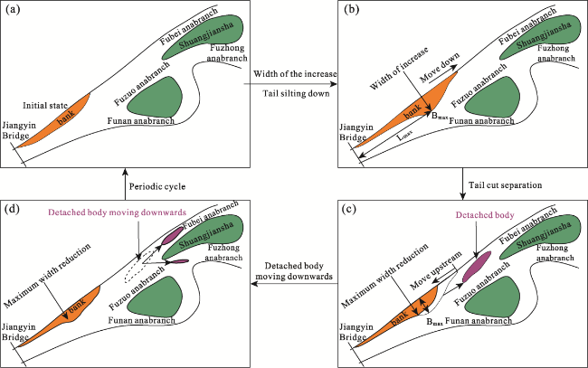
Figure 7 Evolutionary features of the Jingjiang and nearby bank: (a) Original state; (b) Silting state (early); (c) Silting state (late); (d) Transport state

3.3.2 Critical characteristics of the Jingjiang bank scour

Considering the 10.0-m isobath as the object, 13 clear scour processes occurred at the tail of the Jingjiang bank from 1958 to 2019. The maximum width of the 10.0-m isobath of the Jingjiang bank before scour, the longitudinal distance from the Ebizui section, and the critical morphological characteristics of scour were all analyzed (Figure 8a). In general, when the width of the 10.0-m isobath of the Jingjiang bank became ≥1000 m, it was cut during the flood season. The initial scour position was ≤5.0 km downstream of the Jiangyin Yangtze River bridge and was concentrated 5.0-7.5 km downstream of Ebizui (Figures 8b and 8c). Figure 6 displays a maximum width of the 10.0-m isobath of the Jingjiang bank ≥1000 m with a downstream position, primarily due to the tail being scoured or cut abruptly in previous hydrological processes, resulting in the tail sediment being incompletely separated.
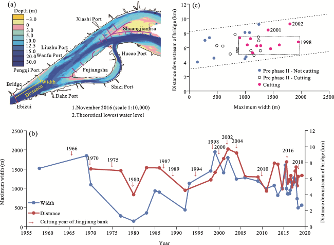
Figure 8 Morphological parameters of scouring in the Jingjiang bank: (a) Map of morphological parameters; (b) Morphological parameters of the Jingjiang bank over the analysis period; (c) Maximum width position

3.4 Critical hydrodynamic characteristics of bank scour

According to the intra-annual evolution and volume changes, the Jingjiang bank was mainly characterized by high and wide siltation during the flood season in May to August 2015 and May to August 2016, leading to increasing bank volumes for 10.0-m and 12.5-m isobaths, respectively. The Jingjiang bank was in the straight and relaxed section; thus, changes in the mainstream power axis adhered to the basic laws of “straight in the flood season and bent in the dry season.” Analyses showed that scouring could only occur when the high and wide siltation at the Jingjiang bank met certain morphological characteristics, particularly when tail scour maintained a long siltation flow in the early hydrological process during flood years. Regarding watershed inflow characteristics (Figure 9), the duration at the Datong Station exceeded 180 d (i.e., the minimum value observed was 180 d, the maximum value was 231 d—mean, 200 d) with 20,000≤Q<40,000 m3·s-1, the siltation of the Jingjiang bank was relatively large, and the maximum width was >1000 m. When the tail of the Jingjiang bank at the Datong Station with Q≥40,000 m3·s-1 commenced scouring, the tail of the bank entered a scour state at Q≥50,000 m3·s-1, lasting for ≥50 days. Additionally, the longer states of Q ≥ 60,000 m3·s-1 last, the larger the volume of the scouring sand bodies.
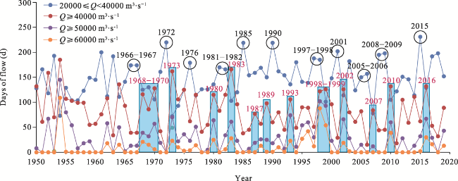
Figure 9 Relationship between the characteristic flows at the Datong station and the scouring in the Jingjiang bank
The statistics revealed that the cycle length of 13 scouring times at the Jingjiang bank was 2-7 years, with 72.7% being concentrated in years 4-6. Analyses also showed that the cycle length of 12 scouring times at the Jingjiang bank increased the percentage falling within 3-6 years to 75.0%. Thus, it was concluded that the main cycle length of scouring at the Jingjiang bank was 3-6 years.

4 Discussion

The scouring processes at the Jingjiang bank directly affect the downstream waterway conditions of the Fubei anabranch. Based on the distribution relationships of sand bodies among branches and longitudinal transport, the influences of scouring sediment downstream were assessed here, and corresponding reference suggestions for waterway dredging and maintenance were provided.

4.1 Distribution relationship of sediment among branch channels

From 1967 to 2018, the diversion relationship between the Funan and Fuzuo anabranches was stable, with a multiyear average split ratio (SR) of 20.0% and 80.0%, respectively (Figure 10a). During 2012-2018, the sediment diversion ratios (SDR) in the Fuzuo and Fubei anabranches were approximately 4.2% and 5.8% higher than their corresponding branching ratios, respectively (Figure 10b).
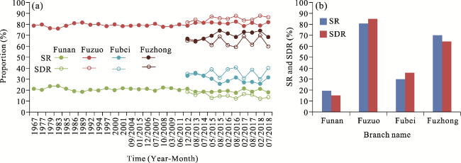
Figure 10 Split ratio and sediment diversion ratio in the Fujiangsha reach: (a) SR and SDR; (b) Relationship between SR and SDR
Following commencement of the Three Gorges Project operations, the runoff control section (Yang et al., 2019, 2021a, 2022c), tidal reach (Zhu et al., 2020a, 2020b; Mei et al., 2021; Xie et al., 2021), and south branch of the Yangtze River estuary (Guo et al., 2021b) were all in a scouring state. Notably, a portion of the fine sediment scoured from the riverbed replenishes the suspended sediment, entering the estuary via water flow (Yang et al., 2013, 2014, 2015). The remaining portion of coarse-grained sediment scoured from the riverbed spreads to the estuary through the tidal reach in the form of bottom sediment (Guo et al., 2019, 2021a). Studies have shown that the bottom sediment transport in the lower tidal reaches of the Yangtze River is relatively active (Chen, 2014; Yang et al., 2020), with sediment shifting occurring primarily in the form of sand wave movement (Zheng et al., 2016, 2018). Riverbed monitoring has shown that sediment concentration near the mouth of the Yangtze Estuary is significantly higher than the suspended sediment concentration (Liu et al., 2011). In this analysis, Dou Guoren’s sediment transport rate formula was selected for calculating sediment transport rates along the riverbed (Eq. 1):
Q b = k C 0 2 γ s γ γ - γ s h ( V - V c ) V 3 g h ω
where V is the bottom velocity (m·s-1); Vc is the sediment threshold velocity (m·s-1), for which a value of 0.42 m·s-1 was used; γs is the bulk density of the sediment; γ is the bulk density of water; ω is the settling velocity; ω = 1.72[(γs-γ)gD/γ]0.5; D is the median particle size of the bed material; C0 is the Chezy coefficient; k is the undetermined coefficient, equal to 0.01; g is the gravitational acceleration constant (9.80 m·s-2); and h is water depth (m).
In February 2016 and August 2016, the suspended sediment transport channel at the Jiangyin section was a deep trough area, with a transport per unit width being significantly higher than that of the Jingjiang bank and Funan anabranch (Figure 11a). Notably, the horizontal difference in sediment transport at the bottom part of the Jiangyin section in the dry season was not significant. During the flood season, however, the path of the sediment transport of the bottom part was mainly along the side of the Jingjiang bank. In August 2016, the suspended SDRs of the Jingjiang bank, deep trough, and Funan side were 53.0%, 34.6%, and 12.4%, respectively. In February 2016 and August 2016, the measured suspended sediment transport channels of the Fuzuo section were along the near-shore of the left bank and the deep trough area. Additionally, the transport intensity was relatively low in the low-bank areas at the head of Shuangjiansha and the left edge of Fujiangsha. In August 2016, the suspended SDRs of the Fubei and Fuzhong anabranches were 21.6% and 78.4%, respectively (Figure 11b). During February 2016, the horizontal difference in the sediment transport at the bottom part of the Fuzuo section was less than that observed in August 2016, when the transport channel was mainly inclined to the Fubei anabranch, and the proportions of the Fubei and Fuzhong anabranches in the flood season were 75.6% and 24.4%, respectively.
Figure 11 Suspended sand and bottom sediment transport pathways of the: (a) Xiaoshan section (1#); (b) Fuzuo section (2#); (c) Sediment grading of the Fuizuo section; (d) Sediment grading of the Fubei section
The measured data showed that the proportion of d≥63 μm suspended sediment at the Xiaoshan section during both the flood and dry seasons was <5%; thus, it was concluded that the proportion of coarse-grained sediment in the suspended sediment of bed-making materials was far less than that of the sediment at the bottom part (Yang et al., 2016). Comprehensive analyses have shown that the suspended sediment at the Fujiangsha inlet was primarily transported along the deep trough, whereas the bottom sediment was transported along the low-bank area of the Jingjiang bank. Alternatively, the suspended sediment transport in the Fuzuo anabranch was concentrated near the shore and deep trough area of the left bank, whereas the sediment at the bottom part of the flood season was mainly transported downstream through the Fubei anabranch.

4.2 Longitudinal transport mechanism of scour band bodies

The scouring sediment at the Jingjiang bank was transported downstream in the form of sediment along the bottom part and can be divided into four modes: Jingjiang bank-Fuzuo anabranch-Fubei anabranch, Jingjiang bank-Fuzuo anabranch-Shuangjiansha low bank, Fujiangsha reach inlet deep trough-Fuzuo anabranch (left)-Fubei anabranch, and Fujiangsha reach inlet deep trough-Fuzuo deep trough (right)-Fuzhong anabranch (see Figure 1 for these section locations).

4.2.1 Transport mode of Jingjiang bank-Fubei anabranch

From August 2013 to August 2015, no scour at the tail of Jingjiang bank was observed, and the previous scouring sand bodies at the tail (from 2010) gradually shifted downstream to the vicinity of the Heshang Port. A portion of the bodies entered the Fubei anabranch, and the imported shoals gradually shifted downstream from near the Xiashi Port to the Danhua-Qinglong Port area (Figure 12). The remaining portion of the body merged with the low bank on the left edge of Shuangjiansha, creating a siltation thickness per unit length higher than that of the Fubei anabranch. From August 2015 to August 2017, the upper-mid section of the Jingjiang bank was scoured, and the tail was cut. Moreover, there was no siltation near the downstream Heshang Port. Simultaneously, the water depth conditions between Xiashi and Qinglong ports of the Fubei anabranch were improving. From August 2015 to August 2017, the siltation thickness of the bank along the left edge of Shuangjiansha was less than that observed from August 2013 to August 2015, while the scouring sand bodies were mainly transported downstream along the Fubei anabranch navigation channel. From August 2013 to August 2017, the deep trough of the Rugao port anabranch had a small range of scouring and deposition, indicative of the strong sediment transport capacity of this waterway.
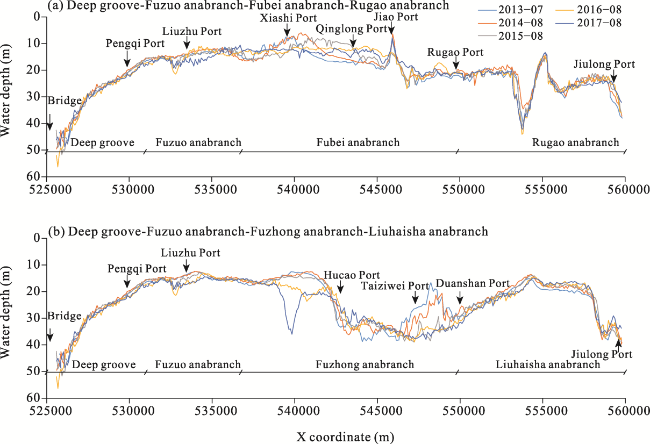
Figure 12 Jingjiang bank to Fubei anabranch transport model: (a) Jingjiang bank-Fubei anabranch-Rugao anabranch; (b) Jingjiang bank-Shuangjiansha-Rugao anabranch

4.2.2 Transport model of deep trough: Fubei and Fuzhong anabranches

From August 2013 to August 2015, the scouring and silting ranges of the deep trough in the inlet section of the Fujiangsha reach, Fuzuo anabranch, and Rugao anabranch were relatively small, thus reflecting the strong sediment transport capacity of the deep trough (Figure 13). The inlet section of the Fuzhong anabranch (downstream of the Funan anabranch inlet) was slightly silted. The maximum scouring depth between the Taiziwei and Duanshan ports was 18.0 m, while the riverbed scouring and siltation of the Liuhaisha anabranch was relatively small. From August 2015 to August 2017, the scouring body at the tail of the Jingjiang bank shifted downstream, the deep trough of the Fuzuo was characterized by head scouring and tail silting, and the water depth of the Xiashi-Qinglong port region in the Fubei anabranch improved. The maximum scouring depth near the spur dike at the inlet of the Fuzhong anabranch was 20 m, whereas the Liuhaisha anabranch was characterized by scouring in the upper section and silting in the lower section, with a relatively small amplitude.
Figure 13 Deep trough to Fubei and Fuzhong anabranch transfer mode: (a) Jingjiang bank-Fubei anabranch-Rugao anabranch and (b) Jingjiang bank-Shuangjiansha-Rugao anabranch
In summary, prior to the commencement of the Shuangjiansha project, the scour body at the tail of the Jingjiang bank entered the deep trough of the Fubei anabranch, as well as the low bank at the left edge of the Shuangjiansha. Simultaneously, the horizontal siltation widening of the low bank along the left edge of the Shuangjiansha constricted waterway width. Since the implementation of the project’s second phase, the scouring sand bodies at the tail of the Jingjiang bank have mostly entered the Fubei anabranch, while the water depth condition of this anabranch improved due to project-related dredging and maintenance. The deep trough of the Fujiangsha inlet section, as well as the Fuzuo, Rugao, and Liuhaisha anabranches maintained strong sediment transport capacity. Prior to implementation of the second phase, the sediment transport capacity of the Fubei anabranch inlet section was relatively weak, and the scouring sand bodies of the Jingjiang bank were primarily deposited within the inlet section. Since the second phase of the project, however, the sediment transport capacity of the river channel has gradually increased, and the resulting change amplitudes of scouring and deposition within the waterway have been small.

4.3 Longitudinal transport of scouring sand bodies, river channel capacity, and maintenance of Fubei anabranch

From December 2012 to August 2015, the channel capacity of the 10.0-m and 12.5-m isobaths in the Fubei anabranch decreased by 25.4% and 16.3%, respectively (Figure 14a). Following the implementation of the Shuangjiansha project’s second phase, the channel capacity of these isobaths did not change significantly from August 2015 to August 2016; however, it has increased since August 2016. Specifically, by April 2019, the cumulative growth rates of the 10.0-m and 12.5-m isobaths were 13.6% and 11.9%, respectively, thus indicating that the second-phase project successfully achieved the intended results. From the relationship between the Fubei anabranch channel capacity and the Jingjiang bank volume (Figure 14b), the 10.0-m and 12.5-m isobaths at the Jingjiang bank decreased with respect to the channel capacity of the Fubei anabranch 12.5-m isobaths, as a function of the shoal body volume. This process was a direct result of the Jingjiang bank being located on the left bank side, upstream of the Fubei anabranch inlet. When elevated and widened by siltation, the squeezed water flow swung to the right, and as this is not conducive to stability or increased inflow conditions in the Fubei anabranch, it shrank the channel capacity of the Fubei anabranch. Accordingly, the results above revealed that when siltation widening at the 10.0-m isobath of the Jingjiang bank was > 1000 m, the tail was cut during flood years, and the disconnected sand bodies entered the Fubei anabranch, thereby further reducing its river channel capacity. Overall, a waterway improvement project with a water depth of 12.5 m has been implemented in the reach below Nanjing since 2015. After the project was implemented, the scale (volume) of the Jingjiang bank was significantly higher than before, which is directly related to the implementation of the spur dike project on the left of Fujiangsha. Additionally, the implementation of the dam project in the Shuangjiansha area plays a more significant role in concentrating hydraulic actions on the sand. Moreover, the increase in hydrodynamic force in the channel is conducive to the transport of sediments to the downstream reaches of the Jingjiang bank.
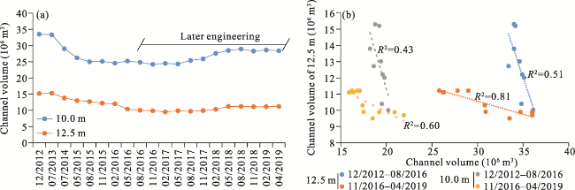
Figure 14 Relationship between the volume of the Jingjiang bank and the channel capacity of Fubei anabranch: (a) Fubei anabranch; (b) Channel and Jingjiang bank volumes
With the increase in the volume of the 10.0-m and 12.5-m isobaths for the Jingjiang bank during 2012-2019, the channel capacity of Fubei anabranch decreased. Here, the conducted sensitivity analyses directly related this decrease with a corresponding increase in the Jingjiang bank by the same volume since the implementation of the second phase of the Shuangjiansha project. In turn, this indicated that the influence of the evolution of the Jingjiang bank on the Fubei anabranch channel capacity was weakened; however, with respect to the sediment transport path, the vertical transport of the upstream sediment (at the bottom part) has gradually changed from Jingjiang bank-low bank at the head of Shuangjiansha-Fubei anabranch, to Jingjiang bank-Fubei anabranch since the implementation of the project’s second phase. Accordingly, the speed of sediment transport at the bottom part of the Fubei anabranch channel capacity was more rapid, subsequently increasing the dredging and maintenance volume of the Fubei anabranch during dry years. For example, during 2018 and 2019, the amount of dredging maintenance for these flood years was dependent upon the sediment transport capacity of the navigation channel and the duration of characteristic flow levels (Table 2).
Table 2 Dredging and maintenance volume of Fubei anabranch
Volume/Year 2010 2011 2012 2013 2014 2015 2016 2017 2018 2019
Dredging and maintenance (×104 m3) 30.03 0 283.36 375.14 404.59 552.625 443 95.84 739.14 886.9
Runoff (×108 m3) 10078 6671 10020 7878 8919 9139 10450 9378 8028 9334
Sediment (×108 t) 1.86 0.718 1.61 1.17 1.20 1.16 1.52 1.04 0.831 1.05
The maintenance water depth of the waterway in the Fujiangsha anabranch is divided into 8.0, 10.5, and 12.5 m. The increase in the maintenance water depth has led to a phased increase in waterway dredging. The year 2015 experienced moderate water flow, whereas 2016 experienced heavy water flow. The number of days in which the flow rate was greater than 50,000 m3·s-1 in two years were 31 and 68 days, respectively—significantly higher in 2016 than in 2015—and the hydrodynamic force during the flood period in 2016 far exceeds that in 2015. Scouring occurred on the Jingjiang bank in 2016, but the eroded sediment rapidly entered the Fubei waterway under high flow conditions during the flood period. The water depth during the flood period exceeded the maintenance target depth, so no dredging measures were required. As a significant amount of sediment was carried to the downstream reaches of the river because of increased hydrodynamic forces during the flood period, it did not cause an increase in dredging maintenance despite scouring along the Jingjiang bank during flood years. After the implementation of the second phase of the 12.5 m deep-water waterway below Nanjing, the overall size of the Jingjiang bank and the scouring volume was reduced. The boundary conditions of the Fubei waterway were gradually stabilized to enhance the return of water flow, facilitating downstream sediment transport from the Fubei waterway. Therefore, this change in the evolutionary model indicates that the waterway improvement project has achieved good results.

4.4 Channel evolution of the tidal reach and its influence on the estuary

The tidal reaches of large rivers worldwide are subject to bank scouring, with significant differences in the extent of scouring due to differences in runoff and tidal hydrodynamics and sediment load.

4.4.1 Influence of water and sediment processes on the evolution of tidal reaches

There was no change in runoff trend at the Datong Station of the Yangtze River between 1956 and 2021. During this period, 1998 was the year of extreme flooding, whereas 2010, 2016, and 2020 were flood years after the Three Gorges Project operationalized (Figure 15). The hydrodynamic conditions were significantly enhanced during flood years, and the increase in the number of flood days caused the degree of deformation of the continental bank to be larger than in years with moderate and lower water flow. Additionally, from 1956 to 2021, the volume of sediment entering the tidal reaches of the Yangtze River basin decreased intermittently, with a 69% reduction between 2003 and 2021 compared to that between 1956 and 2002 (Figure 15). Focusing on the relationship between water and sediment in the tidal reaches of the Yangtze River, the sediment content in the tidal reaches was significantly reduced; moreover, the unsaturated water flow further exacerbated the scouring of banks during flood water years, such as the scouring of Jingjiang bank at the end of 2010 and 2016. During field observations of the middle reaches of the Yangtze River, the bank in the straight sections exhibited periodic upstream and downstream movements, causing adjustments in the diversion of downstream branches or the alternation of branches, such as the Jiepai reach (Liu et al., 2014). Owing to adjustments in the flow processes during the year, after the Three Gorges Project became operational, the side banks on the convex side of curved reaches eroded and showed a trend of under scouring, such as the Xiongjiazhou-Chenglingji reach, with some sharp bends straightened through scouring to form oxbow lakes (Yang et al., 2022a, 2022b, 2023b). In complex branched reaches, frequent scouring of the side banks and the Jiangxin island have deteriorated the river and waterway conditions, such as in the Shashi reach (Zhao et al., 2020; Yang et al., 2021a).
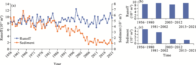
Figure 15 Changes in runoff and sediment of the Datong Station: (a) Runoff and sediment; (b) Runoff; (c) Sediment
The Fujiangsha reach is the fluctuating section of the tidal boundary of the Yangtze River (Yang et al., 2011), and there are reverse flood currents during the dry season, but the riverbed-making dynamics are driven by ebb currents. Relatively significant flood currents exist in the estuarine section of the Yangtze River, creating a high-tide trough, such as the Xinqiao waterway (Chen et al., 2022). When the flow rate exceeds 40,000 m3·s-1, it becomes difficult for the flood currents to move up to the Fujiangsha reach, whereas the increase in minimum flow during the dry season strengthens the effect of the ebb currents. The tidal reaches of large rivers worldwide are subject to bank scouring, with significant differences in the degree of scouring due to differences in runoff and tidal hydrodynamics and sediment load.

4.4.2 Impacts of channel evolution of tidal reach on sediment supply relationship in the estuarine delta

The scouring of the lower Mississippi River in the United States provides a rich source of sand for the estuarine delta (Nittrouer and Viparelli, 2014). It has also been observed in existing studies that the Jiuduansha at the mouth of the Yangtze River is experiencing siltation, but scouring has not occurred because of the reduction in suspended sediment in the basin, which is inextricably linked to the scouring of the tidal reach (Wei et al., 2016, 2017). Sediment transport in the Yangtze River Basin forms a good “source-sink” relationship with the scouring and deposition of the estuarine delta (Guo et al., 2019, 2021a, 2021b, 2022d), and the evolution of scouring and deposition in the foreshore and submerged delta of the Yangtze estuary is closely related to the upstream sediment supply.
During the period 1975-2001, the scouring volume of Yichang-Hukou and Jiangyin- Xuliujing reaches was 21,062×104 m3, and the siltation volume from Hukou-Jiangyin to the mouth of the Yangtze River was 27,048×104 m3. Additionally, approximately 5986×104 m3 of suspended sand was deposited in the foreshore and submerged delta area at the front edge of the mouth of the Yangtze River (Table 3). Based on the distribution of scouring and deposition, the characteristics of upper-reach scouring and deposition in the lower reach are formed. During the period 2001-2021, the stretch from Yichang to the mouth of the Yangtze River experienced an overall trend of scouring, with an average annual scouring volume of 25,147×104 m3; the proportion of contribution from the tidal reach was 46% (Table 3). In summary, the analysis concluded that the tidal reaches of the Yangtze River have shifted from deposition prior to the operation of the Three Gorges Project to scouring after its operation, providing a rich source of sediment for the bank and submerged delta at the front edge of the Yangtze River’s mouth.
Table 3 Statistics of riverbed scouring and deposition from the Three Gorges Dam to the estuary of the Yangtze River
Period Reach
Yichang-Hukou Hukou-Jiangyin Jiangyin-Xuliujing Yangtze Estuary
1975-2001 -16871 12728 -4191 14320
-649 490 -161 573
2001-2021 -262439 -170648 -61700 -8170
-14186 -8532 -3085 -409

5 Conclusions

This study identified the critical morphology and hydrodynamic characteristics of periodic scour in the Jingjiang bank based on measured hydrological and riverbed topography data from the Fujiangsha reach from 1950-2019. Furthermore, the longitudinal transport mechanisms of the scouring sand bodies were also clarified. The main conclusions are as follows:
(1) The Jingjiang bank was located in the changing section of tidal current during the flood season and exhibited periodic evolution characteristics of silting up-scour-silting up, within an evolutionary period ranging from 3-6 years. The critical morphological characteristics of tail scour related to the width of the 10.0-m isobath in the middle and lower sections being >1000 m and the scour position being concentrated in the section 5.0-7.5 km downstream of Ebizui.
(2) Data were recorded for >180 d at the Datong Station with a flow 20,000≤Q≤ 40,000 m3·s-1, with widening by siltation being predominant at the 10.0-m isobath in the middle and lower sections of the Jingjiang bank. When the width was ≥1000 m, scour occurred during flood years. The middle and lower reaches of the Jingjiang bank with Q≥40,000 m3·s-1 began to scour, and the tail was cut in years where Q≥50,000 m3·s-1 lasted for ≥50 d. As the duration of Q≥60,000 m3·s-1, the volume of the cut sand bodies increased.
(3) The low Jingjiang bank was the primary channel for sediment transport from the bottom part. Prior to the commencement of the second phase of the Shuangjiansha project, the longitudinal transport mode of the scouring sand bodies was the Jingjiang bank-low bank at the head of Shuangjiansha-Fubei anabranch. However, since its implementation, the longitudinal transport mode has shifted to the Jingjiang bank-Fubei anabranch.
Since the implementation of the second phase of the Shuangjiansha waterway engineering project (2012), the volume of the Jingjiang bank has been decreasing, and the control of bank size has been conducive to the alleviation of maintenance pressure for the Fubei anabranch; however, the observed changes in longitudinal transport mode of scouring sand bodies at the Jingjiang bank may increase the dredging and maintenance volume of the Fubei anabranch during dry years. Thus, the results suggest the strengthening of water depth and topography monitoring in the Fujiangsha reach during flood years. Additionally, timely dredging measures should be implemented for sand bodies at the inlet of the Fuzuo-Fubei anabranch when the tail of Jingjiang bank is in a scouring state.
[1]
Chen Xiaoyun, 2014. Branch selection of Fujiangsha deep-water channel. Port & Waterway Engineering, 489(3): 1-7. (in Chinese)

[2]
Chen Yongping, Li Jiangxia, Wu Zhigang et al., 2016. Dynamic analysis of riverbed evolution: Chengtong Reach of Yangtze Estuary. Journal of Coastal Research, 75(SI):203-207.

DOI

[3]
Chen Yun, Dai Zhijun, Mei Xuefei et al., 2022. Morphodymamic evolition of the Xinqiao channel in the Changjiang River Estuary. Advances in Marine Science, 40(2): 247-260. (in Chinese)

[4]
Dai Zzhijun, Liu J T, Fu Gui et al., 2013. A thirteen-year record of bathymetric changes in the North Passage, Changjiang (Yangtze) Estuary. Geomorphology, 187: 101-107.

DOI

[5]
Dalrymple Robert W, Choi Kyungsik, 2007. Morphologic and facies trends through the fluvial-marine transition in tide-dominated depositional systems: A schematic framework for environmental and sequence-stratigraphic interpretation. Earth-Science Reviews, 81(3/4): 135-174.

DOI

[6]
Du Dejun, Wang Xiaojun, Xia Yunfeng et al., 2021. Hydrodynamic characteristics of Jingjiang beach evolution. Port & Waterway Engineering, 581(4): 75-80. (in Chinese)

[7]
Guo Leicheng, Su Ni, Townend Ian et al., 2019. From the headwater to the delta: A synthesis of the basin-scale sediment load regime in the Changjiang River. Earth-Science Reviews, 197: 102900.

DOI

[8]
Guo Leicheng, Zhu Chunyan, Xie Weiming et al., 2021a. Changjiang Delta in the Anthropocene: Multi-scale hydro-morphodynamics and management challenges. Earth-Science Reviews, 223: 103850.

DOI

[9]
Guo Xingjie, Fan Daidu, Zheng Shuwei et al., 2021b. Revisited sediment budget with latest bathymetric data in the highly altered Yangtze (Changjiang) Estuary. Geomorphology, 391: 107873.

DOI

[10]
Han Jianqiao, Zhang Wei, Yuan Jing et al., 2018. Channel evolution under changing hydrological regimes in anabranching reaches downstream of the Three Gorges Dam. Frontiers of Earth Science, 12‏(3): 640-648.

DOI

[11]
Hu Ying, Cao Minxiong, Ma Aixing et al., 2020. An analysis of the periodic evolution of the Jingjiang sandbank in the tidal reach of the Yangtze River. Water, 12(6): 1652.

DOI

[12]
Jia Dongdong, Xia Haifeng, Chen Changying et al., 2017. 3-D numerical simulation of the influences of bank erosion processes on navigation conditions: Case study of the Taipingkou waterway on the middle Yangtze River. Advances in Water Science, 28(2): 223-230. (in Chinese)

[13]
Jiang Ninglin, Chen Yongping, Fei Xian, 2011. Analysis of riverbed evolution of Fujiangsha river section. Water Conservancy Science and Technology and Economy, 17(6): 8-9, 20. (in Chinese)

[14]
Li Dongfeng, Lu Xixi, Chen Li et al., 2019. Downstream geomorphic impact of the Three Gorges Dam: With special reference to the channel bars in the Middle Yangtze River. Earth Surface Processes and Landforms, 44(13): 2660-2670.

DOI

[15]
Li Dongfeng, Lu Xixi, Yang Xiankun et al., 2018. Sediment load responses to climate variation and cascade reservoirs in the Yangtze River: A case study of the Jinsha River. Geomorphology, 322: 41-52.

DOI

[16]
Liu Gaofeng, Zhu Jianrong, Wang Yuanye et al., 2011. Tripod measured residual currents and sediment flux: Impacts on the silting of the deepwater navigation channel in the Changjiang Estuary. Estuarine Coastal & Shelf Science, 93(3): 192-201.

[17]
Liu Hongchun, Zhang Wei, Li Wenquan et al., 2013. Evolution characteristics of the left beach of Dongliu waterway and its effect on waterway condition. Port & Waterway Engineering, 482(8): 110-114. (in Chinese)

[18]
Liu Lin, Huang Chengtao, Li Ming et al., 2014. Periodic evolution mechanism of staggered beach in typical straight reach of the Middle Yangtze River. Journal of Basic Science and Engineering, 22(3): 445-456. (in Chinese)

[19]
Liu Xingtong, Xu Yimin, Qu Geng, 2020. Analysis on influencing factors of river course evolution in Maanshan, Yangtze River. China Water Transport, (4): 88-90. (in Chinese)

[20]
Mei Xuefei, Dai Zhijun, Darby Stephen E et al., 2021. Landward shifts of the maximum accretion zone in the tidal reach of the Changjiang Estuary following construction of the Three Gorges Dam. Journal of Hydrology, 592: 125789.

DOI

[21]
Nittrouer J A, Viparelli E, 2014. Sand as a stable and sustainable resource for nourishing the Mississippi River delta. Nature Geoscience, 7(5): 350-354.

DOI

[22]
Qu Hongling, Ma Hongliang, 2019. Analysis on regulation effect of Fujiangsha waterway of the 12.5m deepwater channel of the Yangtze River below Nanjing. Port & Waterway Engineering, 564(12): 7-14. (in Chinese)

[23]
Shen Qi, Wang Wei, Gu Fengfeng, 2020. Fluvial processes of the point bar at the transition area between meander Jiangying reach and bifurcated Fujiang shoal reach. Journal of Sediment Research, 45(2): 23-30. (in Chinese)

[24]
Sun Zhaohua, Feng Qiufen, Han Jianqiao et al., 2013. Fluvial processes of sandbars in the junction reach of single-threaded channel to anabranching channel and its impact on navigation: A case study of the Tianxingzhou reach of the Yangtze River. Journal of Basic Science and Engineering, 21(4): 647-656. (in Chinese)

[25]
Wang Fei, Li Yitian, Liu Ya et al., 2015. Evolution of multi-bar in Shashi reach before and after Three Gorges Reservoir impoundment. Journal of Sediment Research, (4): 1-6. (in Chinese)

[26]
Wang Jianjun, Yang Yunping, Shen Xia et al., 2020. Study on the deformation of the point/channel bar of the variable section of the tidal current limit of Yangtze River and its influence on the scouring and silting of dredged channel. Journal of Basic Science and Engineering, 28(4): 751-762. (in Chinese)

[27]
Wang Zhanghua, Saito Yoshiki, Zhang Qing et al., 2018. Three-dimensional evolution of the Yangtze River mouth, China during the Holocene: Impacts of sea level, climate and human activity. Earth-Science Reviews, 185: 938-955.

DOI

[28]
Wei Wen, Dai Zhijun, Mei Xuefei et al., 2017. Shoal morphodynamics of the Changjiang (Yangtze) Estuary: Influences from river damming, estuarine hydraulic engineering and reclamation projects. Marine Geology, 386: 32-43.

DOI

[29]
Wei Wen, Mei Xuefei, Dai Zhijun et al., 2016. Recent morphodynamic evolution of the largest uninhibited island in the Yangtze (Changjiang) Estuary during 1998-2014: Influence of the anthropogenic interference. Continental Shelf Research, 124: 83-94.

DOI

[30]
Wen Yuncheng, Xu Hua, Xia Yunfeng et al., 2018. Study on evolution characteristics and influencing factors of Jingjiang beach under new water and sediment conditions. Yangtze River, 49(Suppl.1): 6-10. (in Chinese)

[31]
Xie Qiancheng, Yang James, Lundström Staffan T, 2021. Sediment and morphological changes along Yangtze River’s 500 km between Datong and Xuliujing before and after Three Gorges Dam commissioning. Scientific Reports, 11: 13662.

DOI PMID

[32]
Xu Yuan, Gong Hongfeng, Zhang Hua, 2014. Study on branch selection for 12.5 m-deep main channel in Fujiangsha reach downstream the Changjiang River. Port & Waterway Engineering, 491(5): 1-7. (in Chinese)

[33]
Yang Xiao, 2020. Evolution processes of the sandbanks in the Zhenjiang-Yangzhou reach of the Yangtze River and their driving forces (from 1570 to 1971). Acta Geographica Sinica, 75(7): 1512-1522. (in Chinese)

DOI

[34]
Yang Xingwang, Li Qiang, 2013. Evolution analysis and maintenance countermeasures of north channel of Fujiang shoal in Lower Yangtze River. Journal of Waterway and Harbor, 34(1): 50-54. (in Chinese)

[35]
Yang Yunping, Deng Jinyun, Zhang Mingjin et al., 2015. The synchronicity and difference in the change of suspended sediment concentration in the Yangtze River Estuary. Journal of Geographical Sciences, 25(4): 399-416.

DOI

[36]
Yang Yunping, Li Ming, Liu Wanli et al., 2022a. Study on the relationship between beach trough evolution and navigation obstruction characteristics in Jingjiang reach of the Yangtze River. Advances in Water Science, 33(2): 240-252. (in Chinese)

[37]
Yang Yunping, Li Ming, Liu Wanli et al., 2023a. Relationship between potential waterway depth improvement and evolution of the Jingjiang Reach of the Yangtze River in China. Journal of Geographical Sciences, 33(3): 547-575.

DOI

[38]
Yang Yunping, Li Yitian, Han Jianqiao et al., 2011. Variation of tide limit and tidal current limit in Yangtze Estuary and its impact on projects. Journal of Sediment Research, (6): 46-51. (in Chinese)

[39]
Yang Yunping, Li Yitian, Sun Zhaohua et al., 2013. Trends and causes of suspended sediment concentration variation in the turbidity maximum zone at the Yangtze River Estuary. Acta Geographica Sinica, 68(9): 1240-1250. (in Chinese)

DOI

[40]
Yang Yunping, Li Yitian, Sun Zhaohua et al., 2014. Suspended sediment load in the turbidity maximum zone at the Yangtze River Estuary: The trends and causes. Journal of Geographical Sciences, 24(1): 129-142.

DOI

[41]
Yang Yunping, Liu Wanli, Zhang Jie et al., 2022b. Changes of divergence and confluence relationship between Dongting Lake and the Yangtze River after the operation of the Three Gorges Project and its impact on the waterway depth. Frontiers in Earth Science, 10: 829669.

DOI

[42]
Yang Yunping, Yin Hong, Li Ming et al., 2023b. Effect of water depth and waterway obstructions on the divergence and confluence areas of Dongting Lake and the Yangtze River after the operation of the Three Gorges Project. River, 2(1): 88-108.

DOI

[43]
Yang Yunping, Zhang Mingjin, Fan Yongyang et al., 2016. Variation trend and causes of suspended sediment characteristic in Yangtze Estuary. Journal of Basic Science and Engineering, 24(6): 1203-1218. (in Chinese)

[44]
Yang Yunping, Zhang Mingjin, Liu Wanli et al., 2019. Relationship between waterway depth and low-flow water levels in reaches below the Three Gorges Dam. Journal of Waterway Port Coastal and Ocean Engineering, 145(1): 04018032.

DOI

[45]
Yang Yunping, Zheng Jinhai, Zhang Huaqing et al., 2022c. Impact of the Three Gorges Dam on riverbed scour and siltation of the middle reaches of the Yangtze River. Earth Surface Processes and Landforms, 47(6): 1514-1531.

DOI

[46]
Yang Yunping, Zheng Jinhai, Zhang Mingjin et al., 2020. Driving mechanism of Sanyiqiao point bar and shoal evolution in fluctuation segment of tidal current limit in lower reaches of Yangtze River. Advances in Water Science, 31(4): 502-513. (in Chinese)

[47]
Yang Yunping, Zheng Jinhai, Zhang Mingjin et al., 2021a. Sandy riverbed shoal under anthropogenic activities: The sandy reach of the Yangtze River, China. Journal of Hydrology, 603: 126861.

DOI

[48]
Yang Yunping, Zheng Jinhai, Zhang Wei et al., 2021b. Quantitative relationship between channels and bars in a tidal reach of the lower Yangtze River: Implications for river management. Journal of Geographical Sciences, 31(12): 1837-1851.

DOI

[49]
Yang Yunping, Zheng Jinhai, Zhu Lingling et al., 2022d. Influence of the Three Gorges Dam on the transport and sorting of coarse and fine sediments downstream of the dam. Journal of Hydrology, 615: 128654.

DOI

[50]
Ying Hanhai, Tan Zhiguo, Wen Yuncheng et al., 2020. Evolution trend of Gaogang side beach in lower reaches of the Yangtze River and its influence on deep water navigation. Port & Waterway Engineering, 571(7): 111-114. (in Chinese)

[51]
You Xingying, Zhang Xiaofeng, Wan Wei et al., 2020. Mutability and periodicity of the characteristic flow level of bifurcated reaches in the middle reaches of the Yangtze River. Journal of Hydrologic Engineering, 25(9): 05020027.

DOI

[52]
Yuan Xiaoting, Cheng Heqin, Zheng Shuwei et al., 2019. A study on the trend and change mechanism of tidal dynamic at Datong-Nanjing reach of the Yangtze River in recent years. Marine Science Bulletin, 38(5): 553-561. (in Chinese)

[53]
Zhang Wei, Yuan Jing, Han Jianqiao et al., 2016. Impact of the Three Gorges Dam on sediment deposition and erosion in the middle Yangtze River: A case study of the Shashi Reach. Hydrology Research, 47(Suppl.1): 175-186.

DOI

[54]
Zhang Xudong, Jin Zhenyu, Liu Hong et al., 2017. Difficulties and countermeasures of dredging scheme for 12.5 m deepwater channel of north Fujiangsha waterway. Port & Waterway Engineering, 536(11): 146-152. (in Chinese)

[55]
Zhao Weiyang, Yang Yunping, Zhang Huaqing et al., 2020. Adjustment patterns and causes of the morphology of sandy riverbed downstream of the Three Gorges Dam. Advances in Water Science, 31(6): 862-874. (in Chinese)

[56]
Zheng Shuwei, Cheng Heqin, Shi Shengyu et al., 2018. Impact of anthropogenic drivers on subaqueous topographical change in the Datong to Xuliujing reach of the Yangtze River. Science China Earth Sciences, 61(7): 1-11.

DOI

[57]
Zheng Shuwei, Cheng Heqin, Zhou Quanping et al., 2016. Morphology and mechanism of the very large dunes in the tidal reach of the Yangtze River, China. Continental Shelf Research, 139: 54-61.

DOI

[58]
Zhou Liang, Shi Yong, Zhao Yaqing et al., 2021. Extreme floods of the Changjiang River over the past two millennia: Contributions of climate change and human activity. Marine Geology, 433: 106418.

DOI

[59]
Zhou Xiaoyan, Dai Zhijun, Mei Xuefei, 2020. The multi-decadal morphodynamic changes of the mouth bar in a mixed fluvial-tidal estuarine channel. Marine Geology, 429: 106311.

DOI

[60]
Zhou Zeng, Coco Giovanni, Townend Ian et al., 2017. Is “Morphodynamic Equilibrium” an oxymoron? Earth-Science Reviews, 165: 257-267.

DOI

[61]
Zhu Boyuan, Deng Jinyun, Tang Jinwu et al., 2020a. Erosion-deposition patterns and depo-center movements in branching channels at the near-estuary reach of the Yangtze River. Frontiers of Earth Science, 14(3): 537-552.

DOI

[62]
Zhu Boyuan, Li Yitian, Yang Peiyan et al., 2018. River bed erosion and deposition responses to sediment reduction in the Chengtong reach of the Yangtze River. Advances in Water Science, 29(5): 706-716. (in Chinese)

[63]
Zhu Boyuan, Li Yitian, Yue Yao et al., 2020b. Alternate erosion and deposition in the Yangtze Estuary and the future change. Journal of Geographical Sciences, 30(1): 145-163.

DOI

[64]
Zhu Lingling, Ge Hua, Zhang Wei, 2011. Evolution trend and causes of the typical braided middle Yangtze reach after Three Gorges Reservoir impoundment. Journal of Hydroelectric Engineering, 30(5): 106-113. (in Chinese)

Outlines

/