Research Articles

OSL chronology reveals Late Pleistocene floods and their impact on landform evolution in the lower reaches of the Keriya River in the Taklimakan Desert

  • ZHANG Feng ,
  • WANG Jiao ,
  • MA Li ,
  • Dilibaier TUERSUN
Expand
  • College of Geography and Remote Sensing Sciences, Xinjiang Key Laboratory of Oasis Ecology, Xinjiang University, Urumqi 830046, China

Zhang Feng (1973-), PhD and Professor, specialized in Quaternary environmental change. E-mail:

Received date: 2022-11-20

  Accepted date: 2022-12-30

  Online published: 2023-05-11

Supported by

National Natural Science Foundation of China(U1503381)

National Natural Science Foundation of China(40701188)

National Natural Science Foundation of China(41161034)

National Science & Technology Infrastructure Center of China(2017FY101004)

The Tianshan Cedar Project of Xinjiang Uygur Autonomous Region(2017XS21)

Abstract

The impacts of climate change on the relationship between fluvial processes and dune landform evolution have been studied. However, the chronology data used to examine this relationship are deficient. The Keriya River has a glacial origin in the Kunlun Mountains on the south margin of the Tarim Basin. The river flows into the Taklimakan Desert, the second largest shifting-dune desert in the world. The dry channels and shifting dunes in this area provide an ideal opportunity to investigate fluvial and aeolian landform evolution processes and their relationship with climate change. We investigated this area during 2008-2011 and obtained 18 fluvial sediment samples from 16 sections for optically stimulated luminescence (OSL) dating. The results show that the ages ranged from 3.4-44.1 ka. Most of the samples (13) were Holocene in age, around 11 ka, 8-9 ka, 5-6.5 ka, 4.6 ka, and 3.4-3.7 ka and were distributed along ancient river channels around sites of Yuansha and Karadun. Two samples close to the Hotan River (38-47 ka) fall within the Marine Isotope Stage 3 (MIS3). Three samples (from one section) were located near ancient channels flowing towards the Yuansha Site and had ages of around 14.5 ka, i.e., during the Last Glacial Maximum (LGM). The analyses of the sediment samples and OSL ages suggest that the Keriya River flooded in the Holocene, the LGM, and MIS3. Fluvial sediments provided the source material for the dunes, and fluvial processes affected the landform evolution in the lower Keriya River. Our results suggest that most of the dunes covered in fluvial sediments in the lower reaches and the area west of the Keriya River developed since the Holocene. This differs from the results of previous studies, which suggested that they developed since the Han (202BC-220AD) and Tang (618-907AD) dynasties. The OSL ages of the fluvial sediments are consistent with the reported deglaciation (after glacial advance) ages in the alpine mountains surrounding the Tarim Basin. This suggests that climate fluctuations may have affected the occurrence of floods and the formation of dunes in the Taklimakan Desert.

Cite this article

ZHANG Feng , WANG Jiao , MA Li , Dilibaier TUERSUN . OSL chronology reveals Late Pleistocene floods and their impact on landform evolution in the lower reaches of the Keriya River in the Taklimakan Desert[J]. Journal of Geographical Sciences, 2023 , 33(5) : 945 -960 . DOI: 10.1007/s11442-023-2114-x

1 Introduction

The Taklimakan Desert is the largest desert in China (Zhu et al., 1980, 1981; Yang, 2000; Fang et al., 2001; Sun and Liu, 2006; Yang et al., 2011b; Zheng et al., 2015). Regarding its formation, Shumef argued that it was a marine plain (Zhu et al., 1981; 2013; Yang et al., 2011b), and Norin and Sinintsyn believed that it was an ancient lake (Zhu et al., 1981; 2013; Yang et al., 2011b). Zhu et al. (1988) studied the dry delta in the lower Keriya River and proposed that the desert in this area was formed on the fluvial alluvial plain, the desert sands largely originate in situ from the underlying sands, which was later supported by the chronological data from the interior of the desert (Cao and Xia, 1992; Li et al., 1993; Jin and Dong, 2001). Regarding the formation age of the Taklimakan Desert, some scholars have determined the sedimentary age of the loess in the northern margin of the Kunlun Mountains (Fang et al., 2001; Sun and Liu, 2006), as well as the modern circulation pattern in the Tarim Basin (Yang, 2000), and they concluded that the desert originated in the Middle Pleistocene (Fang et al., 2001) and the Late Tertiary (Sun and Liu, 2006). The sedimentary layers in the desert also formed in the Late Cenozoic (Chang et al., 2012) and Miocene (Zheng et al., 2015). The optical stimulated luminescence (OSL) ages of sand sediments under the surface clay-silt layer in the lower reaches of the Yatonggusi (Yawatongguz) River and the Andier (Andir) River (Yang et al., 2006), directly in the interior of the Taklimakan Desert, indicate that the river sediments were deposited at about 40 ka and could have provided a provenance for the desert. It seems that the era of the formation of modern desert landscape was quite recent. Are the desert areas in the lower reaches of other rivers in the southern margin of the Tarim Basin similar to this?
The Keriya River originates in the Kunlun Mountains and penetrates deep into the hinterland of the Taklimakan Desert (Figure 1) (Zhu et al., 1988; Zhou et al., 1994; Yang et al., 2002; Shi et al., 2019), and its basin area ranges as far as the Tarim River in the north. The river system and the desert landforms are well developed (Zhu et al., 1988; Zhou, 1991; Cao and Xia, 1992; Yang et al., 2002; Zhang et al., 2011), and oasis relics are abundant (Abdurusul et al., 1998) in the downstream area of the Keriya River, which is an ideal place to study the interior of the desert. The lower reaches of the Keriya River have been listed as a key area by Lanzhou Institute of Desert Research, Chinese Academy of Sciences (Zhu et al., 1981; Yang, 1986) and by the first comprehensive Taklimakan Desert expeditions (Wen, 1988). Moreover, relevant research has provided an important basis for understanding the formation and evolution of the Taklimakan Desert. Cao and Xia (1992), Zhou et al. (1996), Li et al. (1993, 2002) and Jin et al. (1994) determined the 14C and thermoluminescence ages of the desert sediments and obtained an outline of the desert’s evolution in this region. However, the reservoir effect (Deevey et al., 1954) of the 14C age was discussed less in early studies, and the thermoluminescence ages may be subject to large errors due to partial bleaching (Lu et al., 1991), which affects our understanding of the evolution of the deserts in the Keriya River and its basin area.
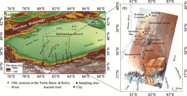
Figure 1 (a) Elevation map of the Tarim Basin (ASTER GDEM). The red solid triangles denote the locations of the sampling sites with published ages: ① lower reaches of the Yatonggusi River and Andier River (Yang et al., 2006), ② sand wedges in upper reaches of the Cele River (Yang et al., 2006), ③ lower reaches of the Tumiya River (Yang et al., 2006), ④ Yohan Tohrak section (Cao and Xia, 1992; Yang et al., 2006), ⑤ Pulu Yangchang section (Han et al., 2014), ⑥ Bosten Lake section (Chen et al., 2006), ⑦ Mazatage dried river channel section of Hotan River (Jin et al., 1994), ⑧ Keriya section in the center of the desert (Jin et al., 1994), ⑨ middle reaches of the Tarim River (Feng et al., 1996; Feng and Wang, 1998), ⑩ Keriya section (Li et al., 1993), ⑪ Aqiang section (Li et al., 2008a), ⑫ Muzhaerte Pochengzi moraine (Zhao et al., 2009), ⑬ Chongce glacial moraine (Jiao et al., 2000), ⑭ Tianshuihai Lake lacustrine deposits (Li et al., 2008b), ⑮ Keliya glacial moraine (Li et al., 2012),⑯ Kongur Mountain moraine (Seong et al., 2009; Wang et al., 2011); (b) Processed Landsat8 (Operational Land Imager, OLI) false color image (RGB: 7-5-2) showing the lower reaches of the Keriya River and the sampling sites in this study.
The optical stimulated luminescence technique has recently become an important means of studying desert evolution (Zhang et al., 2015) because it is ideal for dating the burial age of young geological bodies (Lai and Ou, 2013) and aeolian sands (Stokes et al., 2004) and fluvial sediments (Zhao et al., 2011) exposed well in desert environments. However, few OSL ages have been reported in the study area at present, and the published ages are mainly concentrated in the Late Holocene (Yang et al., 2006; Zhang et al., 2011). In this study, new OSL ages for a wider range of sediments in the lower reaches of the Keriya River and the interior of the Taklimakan Desert were obtained, providing new data for understanding the formation and evolution of the desert landforms in the lower reaches of the Keriya River and the Taklimakan Desert.

2 Regional setting

The lower reaches of the Keriya River have a warm temperate desert climate (Zhou et al., 1996). Taking Daliyaboyi as an example, the annual precipitation is less than 10 mm/a (Zhou et al., 1996) and the annual average temperature is about 11.8°C (2015) (Huang et al., 2019). The Keriya River is mainly fed by snow and ice melt water from the Kunlun Mountains (Zhou et al., 1996), with an annual runoff of about 9×10⁸ m3. There are two flood periods in spring and two dry periods in summer according to the Xinjiang Hotan Hydrology Bureau, and seasonal rivers develop in the downstream area in the desert (Zhou et al., 1996). The annual sediment transport of the Keriya River is about 3.51×10⁶ t (Zhu et al., 1988). The vegetation in the study area includes Populus euphratica, Populus Schrenk, Tamarix spp., and Phragmites australis etc. (Shi et al., 2019).
The lower reaches of the Keriya River can be roughly divided into two parts. The upper part extends from Yutian County to Misalai, and the lower part is north of Misalai (Figure 1b). The upper part of the river is relatively fixed, and river terraces from old to new in age are located in Yohan Tohrak, Yutian-Keriya Bridge, and Misalai (Yang, 1990; Cao and Xia, 1992; Zhou et al., 1996; Li et al., 2002; Yang et al., 2006). The lower reaches of the Keriya River consist of the Daliyaboyi desert riparian forest oasis, which formed at about 0.4 ka (Yang, 1990; 2001). There is a dry delta 20 km to the west of Daliyaboyi township, and Karadun Site was located in this area from the Han (202BC-220AD) to the Tang dynasty (618-907AD) (Abdurusul et al., 1998). Another dry delta and ancient river channel leading to Yuansha Site can be seen to the west of Misalai on the remote sensing image in Figure 1b (Abdurusul et al., 1998; Zhang et al., 2011; Xia and Zhang, 2016), and Yuansha Site existed from the Spring and Autumn Period (716-475BC) to the Wei and Jin dynasties (220-420AD). Two older Bronze Age sites are located deeper in the desert and about 80 km north of Yuansha Site (Abdurusul et al., 2012). The Dandanwulik Site from the Tang Dynasty (Zhu et al., 1988) and its dry delta are located in the upper part of the lower reaches of the Keriya River. Ancient river networks, barchan dunes, and barchan dune chains are densely distributed in the dry deltas, and large sand dunes are mostly distributed in the peripheral areas (Figure 1b).

3 Materials and methods

The sampling sites in this study were mostly located in the western part of the lower reaches of the Keriya River, especially deep in the desert between the modern Hotan River and Keriya River. Eighteen samples for OSL chronology were collected from 16 sections (Figures 1 and 2), and the sections exhibited a sedimentary cycle structure of interbedded clay and silt (Figure 2). Sections KU1, KU2, KU3, and KU16 are located along the ancient river leading to Yuansha Site. Section KU1 is from a wind-eroded terrace, and section KU2 is from a wind-eroded valley. These two sections are about 2.5 km apart. Section KU3 is from a wind-eroded outcrop. Sections KU5, KU11, and KU12 are located between the modern Keriya River and the ancient river channel leading to Yuansha Site. Section KU5 is an excavated outcrop. The upper part is aeolian sand, the sediment in the lower part (081013-7) has wavy bedding, and the bottom is aeolian sand with inclined bedding (081013-7). Sections KU16, KU11, and KU12 are all located on the slope of a wind-eroded river valley. Sections KU18 and KU19 are remnants of a wind-eroded floodplain in the eastern part of Yuansha Site, with clay-silt and silty sand in the bottom of the sections, and populus plants remain in both sections. Sections KD1 and KD2 are located in Karadun Site. Section KD1 is from a wind-eroded riverbed, and section KD2 is a tamarix sand pile on the west side of the riverbed. Sections KU10 and KU13 are from wind-eroded outcrops of an ancient riverbed, which is located close to the Hotan River (Figure 1b).
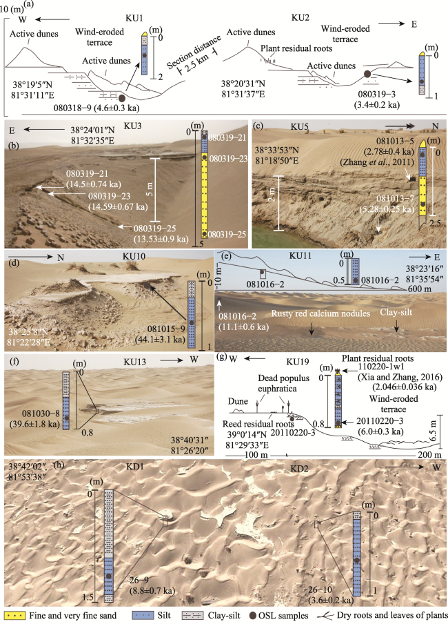
Figure 2 Sampled sections: lithology and sediment OSL samples
The sand samples for OSL dating were collected from freshly excavated sand sediments under the clay-silt layer, and the sample burial depth and excavation depth were both greater than 50 cm. The samples were collected in a stainless-steel tank and were exposed to as little light as possible. The sample container was quickly sealed using aluminum foil. Five OSL samples with laboratory numbers beginning with 12009 were tested at the Cold and Arid Regions Environmental and Engineering Research Institute, Chinese Academy of Sciences, in 2009. The equivalent dose (DE) was determined using a Riso-TL/OSL-DA-15 optometer (Denmark) with a 90Sr/Y radioactive source. Quartz from the sand samples was used for the OSL dating, except for sample 080319-25, for which feldspar was used. The highest water content was 3.1%, and the error was calculated to be 50%.
The ages of the 10G sequence samples (measured in 2010) and 11G sequence samples (measured in 2011) were measured in the Optically Stimulated Luminescence Laboratory, Institute of Hydrogeology and Environmental Geology, Chinese Academy of Geological Sciences. The quartz in the sand samples was used for the OSL dating. According to the experimental report, a Daybreak 2200 (USA) optical luminescence instrument and 801E irradiator (β source 90Sr-Y) were used, and the dose rate was about 0.103871 Gy/Secβ. Coarse particles (90-125 μm) from samples 11G-228 and 11G-234 were measured using the single-aliquot regenerative-dose protocol (SAR) with a preheat temperature of 260°C and a recycling ratio of less than 5%. The DE values of fine particles (8-15 μm) from the other samples were measured using the simplified multiple aliquot regenerative-dose (MAR) protocol and were fitted using the saturating exponential method. The U, Th, and K contents were measured using the neutron activation method, and the contribution of cosmic rays was calculated according to Prescott and Hutton (1994). The water contents of the 10G sequence samples were estimated to be 10%, and those of the 11G sequence samples were estimated to be (5±1) %, both of which were modified using the Fleming method (Prescott and Robertson, 1997).
The U, Th, and K contents reported by the two laboratories are consistent (Table 1), and the age error is basically within 10%. Moreover, the OSL ages of the sediments in this region are in good agreement with the 14C ages of the plants in the same layer (Zhang et al., 2011), suggesting that the results are reliable. The OSL age of sample 080319-25 from the bottom of section KU3 is younger than the other two samples located above it (Figure 2), but the ages of the three samples are basically the same within the error range, and the mineral measured in these samples was feldspar, which indicates that OSL dating is reliable for desert sample age determination.
Table 1 OSL ages of the sediment samples from the lower reaches of the Keriya River in the Taklimakan Desert
Section Laboratory number Field number U (ppm) Th (ppm) K (%) DE (Gy) D (Gy/ka) Age (ka)
KU1 10G-268 080318-9 2.48±0.09 9.64±0.28 1.78±0.06 16.69±0.80 3.63±0.15 4.6±0.30
KU2 10G-269 080319-3 2.50±0.09 11.1±0.31 1.61±0.06 12.37±0.56 3.62±0.15 3.4±0.20
KU4 10G-270 080321-1 1.69±0.07 7.50±0.23 1.73±0.06 23.10±1.09 3.13±0.13 7.4±0.40
KU11 10G-271 081016-2 3.16±0.11 14.2±0.38 1.70±0.06 47.03±1.46 4.23±0.17 11.1±0.60
KU12 10G-272 081022-3 2.10±0.08 8.00±0.24 1.87±0.06 30.00±0.57 3.44±0.10 8.7±0.40
KU13 10G-273 081030-8 2.27±0.09 6.91±0.23 1.76±0.06 138.59±3.03 3.30±0.13 39.6±1.80
KU14 10G-275 081104-1 1.96±0.08 7.75±0.23 1.68±0.06 20.09±0.22 3.20±0.16 6.3±0.30
KU15 10G-276 081106-2 1.87±0.07 7.12±0.21 1.82±0.06 24.34±0.24 3.25±0.10 7.5±0.30
KU10 10G-277 081015-9 1.91±0.07 9.55±0.28 1.81±0.06 153.42±8.79 3.48±0.17 44.1±3.10
KU18 11G-228 20110215-4 2.27 7.77 1.67 16.73±0.66 2.99 5.6±0.30
KU19 11G-229 20110220-3 2.07 8.52 1.69 20.38±0.48 3.37 6.0±0.30
KD1 11G-234 26-9 1.87 7.86 1.54 24.32±1.55 2.76 8.8±0.70
KD2 11G-235 26-10 1.99 6.68 1.69 11.64±0.33 3.21 3.6±0.20
KU3 12009-28 080319-21 2.59±0.10 6.59±0.20 1.78±0.05 42.44±1.83 2.93±0.08 14.50±0.74
KU3 12009-29 080319-23 2.30±0.09 8.06±0.23 1.58±0.05 40.44±1.11 2.77±0.09 14.59±0.67
KU3 12009-30 080319-25 2.40±0.09 8.06±0.23 1.73±0.05 44.26±2.89 3.27±0.12 13.53±0.90
KU5 12009-32 081013-7 2.5±0.09 9.26±0.26 1.8±0.05 16.52±0.63 3.13±0.09 5.28±0.25
KU16 12009-37 081107-1 2.52±0.09 8.63±0.25 1.72±0.05 11.18±1.83 3.00±0.08 3.72±0.62

4 Results

Most of the OSL ages reported here (for 13 samples) are in the Holocene (Figure 1b and Table 1). The samples from Misalai to Yuansha Site yielded the following OSL ages: sample 080319-3 from section KU2 is (3.4±0.2) ka, sample 080318-9 from section KU1 is (4.6±0.3) ka, and sample 081107-1 from section KU16 is (3.72±0.62) ka. Sample 20110215-4 from section KU18 and sample 20110220-3 from section KU19 from the eastern dry delta in Yuansha Site yielded OSL ages of (5.6±0.3) ka and (6.0±0.3) ka, respectively (Figure 2). Sample 081104-1 from the northernmost section KU14 in the Yuansha delta and sample 080321-1 from the western section KU4 in the ancient river channel leading to Yuansha Site yielded OSL ages of (6.3±0.3) ka and (7.4±0.4) ka, respectively. The OSL age of sample 26-9 from section KD1 in the ancient riverbed to the north of Karadun Site is (8.8±0.7) ka, and that of sample 26-10 from section KD2 in the tamarix sand pile is (3.6±0.2) ka, both of which are in the Holocene. The OSL ages of samples 081013-7 (from section KU5), 081022-3 (from section KU12) and 081106-2 (from section KU15) located between sites of Yuansha and Karadun are (5.28±0.25) ka, (8.7±0.4) ka, and (7.5±0.3) ka, respectively. Samples 080319-21, 080319-23, and 080319-25 from section KU 3 on the west side of the ancient river channel leading to Yuansha Site yielded OSL ages of (14.5±0.74) ka, (14.59±0.67) ka, and (13.53±0.90) ka, respectively, which are similar in age and correspond to the end of the last glacial maximum (LGM). The OSL ages of samples 081015-9 (from section KU10) and 081030-8 (from section KU13) from near the Hotan River are (44.1±3.1) ka and (39.6±1.8) ka, respectively, which correspond to marine isotope stage 3 (MIS3).

5 Discussion

5.1 Fluvial activities

The ages of the fluvial sediment samples represent the time during which fluvial activity occurred. The OSL ages of the samples from the delta around sites of Yuansha and Karadun and the fluvial sediments between them range from 3 to 11 ka, indicating that there was river activity during the Holocene. The OSL age of the wind-eroded ancient bank slope section KU2 (sample 080319-3 (3.4±0.2) ka) indicates that the river flowed at that time, and its terrace section KU1 could have been deposited by fluvial activity at (4.6±0.2) ka (Figure 2). The ancient river may have flowed through section KU16 (sample 081007-2(3.72±0.62) ka) on the west side of Yuansha Site to the Beifang Cemetery area at about 3.7 ka. Sections KU11 and KU12 reflect that the Keriya River flowed through this area at (11.1±0.6) ka and (8.7±0.4) ka. The OSL age of aeolian sand sample 081013-7 (5.28±0.25) ka from the bottom of section KU5 indicates that aeolian activity occurred in this area at an earlier time, while the age of fluvial sediment sample 081013-5 (2.78±0.4) ka (Zhang et al., 2011) from the top of section KU5 indicates the existence of rivers in this area in a later period. Sections KU4, KU14, KU15, and KU16 all reflect the wide range of fluvial activity that occurred in the Holocene. The OSL ages of sections KU18 and KU19 (Figure 2) are basically the same, indicating that the Keriya River could have flowed through the area east of Yuansha Site around 6.0 ka, while a 14C data (Xia and Zhang, 2016) reflects that the river could have once flowed to this area at 2.3 ka and that vegetation developed at that time. Sections KD1 and KD2 (Figure 2) reveal that the Keriya River flows through this area at about 8.8 ka and reached Karadun at about 3.6 ka. The spatial distribution of the OSL age samples (Figure 1b) also reflects the migration of the Keriya River between Yuansha and Karadun sites during the Holocene. Sections KU5, KU11, and KU12 could be the records of the river’s migration at (2.78±0.4) ka (Zhang et al., 2011), (11.1±0.6) ka, and (8.7±0.4) ka, respectively (Figures 1b and 2).
The topography controls the direction in which the river flows, and the terrain in the lower reaches of the Hotan River and Keriya River is generally inclined to the north, which is consistent with the flow directions of the modern Hotan River and Keriya River. The study area is located on the flood plain between the two rivers, and the terrain in this area is generally flat. The elevation difference in the east-west direction is particularly small (Figure 1), which makes it easy for the river to change course. As rivers in the desert environment are vulnerable to infiltration and evaporation, it is difficult for the small rivers in the southern edge of the Tarim Basin, such as Cele River, to reach the locations of the samples collected from sections KU10 and KU13 under the existing runoff conditions. However, the spatial distribution of the OSL samples on remote sensing images (Figure 1b) shows that the Keriya River has mainly been active around Yuansha and Karadun sites during the Holocene, and the Hotan River has also mainly been active around the modern rivers for about 20,000 years according to the sections of the Mazatage dried river channel (Jin and Dong, 2001). Thus, the Keriya River or Hotan River is hypothesized to swing greatly and flow to sections KU10 and KU13 only during large-scale flood periods. Alternatively, the groundwater level will rise during the flood, which will provide the conditions for the rivers in the southern edge of the Tarim Basin to flow into the desert. The OSL ages of the fluvial sediments from sections KU10 and KU13 are consistent with the fluvial and lacustrine sediments in the lower reaches of the Yatonggusi River and Andier River (Yang et al., 2006), which indicates that flood events could have occurred in the southern edge of the Tarim Basin at the end of MIS3.
Section KU3 has a depth of 5 m (Figure 2), and the sediments in the top 1 m have a structure consisting of an upper clay-silt layer and lower silt layer. The OSL ages of the three samples from section KU3 are around 14.5 ka, which are consistent with that of the Yohan Tohrak flood accumulation terrace in the upper part of the lower reaches of the Keriya River (Figure 3) (Cao and Xia, 1992; Yang et al., 2006), which suggests that the lower reaches of the Keriya River was influenced by flood activity during the end of the LGM.
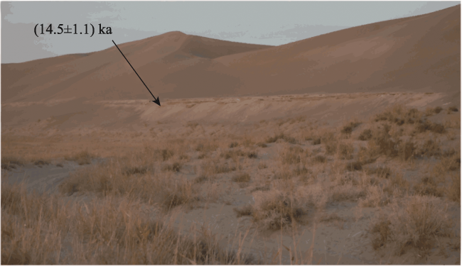
Figure 3 Image showing the terrace in Yohan Tohrak. The OSL chronology data are from Yang et al. (2006).

5.2 Climate background

5.2.1 MIS3

In the Tarim Basin, many factors contribute to river floods, such as dam break floods in mountainous areas and changes in the precipitation variability (Shen et al., 2004). Generally, river floods are mainly controlled by climate changes, such as glacier melting caused by increased temperature, solar radiation, precipitation, and humidity (Yang et al., 2006). The samples from sections KU10 and KU13 yielded OSL ages of 38-47 ka, during which no significant wetting occurred in the Taklimakan Desert according to the loess records in the northern slope of the Kunlun Mountains (Li et al., 2008a). Therefore, the fluvial and lacustrine deposits in sections KU10 and KU13 in the hinterland of the desert could not be the result of increased precipitation. Correspondingly, the Tibetan Plateau glaciers may have melted around 38-47 ka. In addition, a high lake level of Tianshuihai Lake in the upper reaches of the Keriya River yielded a uranium series age of (41.706±4.749) ka (Li, 2000; Li et al., 2008b). The increase in river runoff caused by deglaciation in the northern foothills of the Tibetan Plateau may have led to the formation of sections KU10 and KU13 and the fluvial and lacustrine deposits in the lower reaches of the Yatonggusi River and Andier River (Yang et al., 2006) in the Taklimakan Desert. However, some reports suggest glacier advances, including electron spin resonance (ESR) ages of 39.5(±10%) ka and 40.4(±10%) ka for moraines at the mouth of the Muzhaerte River valley at an altitude of about 1900 m above sea level at the southern foot of the Tianshan Mountains (Zhao et al., 2009), OSL ages of (36.6±3.0)-(40.9±3.5) ka for moraines in the Hindu Kush Mountains in Central Asia (Owen et al., 2002), ESR ages of (36.4±3.3)-(48.7±5.7) ka for moraines in the Kongur Mountains in the western Kunlun Mountains (Wang et al., 2011), and an OSL age of (40.6±0.32) ka from a sand wedge in the upper reaches of the Cele River in the southern edge of the Tarim Basin (Yang et al., 2006) (Figures 1a and 4). The glacial advances mentioned above are close to the glacier deglaciation in this paper in terms of the age data, but they do not contradict each other because the climate fluctuated violently during MIS3, and the deglaciation may have followed the glacial advance.

5.2.2 End of the LGM

The climate changes in the Taklimakan Desert have not been significant since the LGM (Li et al., 1993). The Tibetan Plateau may have developed subpolar type glaciers (Shi et al., 1997). The 14C ages of glacial moraines at the front of Keliya Glacier are (15.55±0.15) ka and (15.79±0.384) ka (Li et al., 2012), a sand wedge on a terrace of the Cele River in front of the Kunlun Mountains has an OSL age of (18.3±1.3) ka (Yang et al., 2006), and the ESR age of the third cluster end moraine of the Pochengzi Glaciation is 13.6 ka (±10%) (Zhao et al., 2009) (Figures 1a and 4). However, the temperature fluctuated and increased after the LGM, and the resultant glacier melting may have caused flooding of the Keriya River, which may have formed the fluvial and lacustrine deposits in Yohan Tohrak (Cao and Xia, 1992; Yang et al., 2006) around 14 ka and may have allowed the river to flow to section KU3. Correspondingly, the deglaciation and high lake level could also have occurred in the northern margin of the Tibetan Plateau, and the lacustrine deposits in the posterior margin of the moraines of Chongce Glacier formed during the end of the LGM, with a 14C age of (14.93±0.37) ka (Jiao et al., 2000).

5.2.3 The Holocene

The fluvial flood deposits formed at the end of MIS3 and the LGM correspond well with the deglaciation after the glacial advance, and a similar process could have occurred in the Holocene due to the significant climate fluctuations. In the Early Holocene, an end moraine of the Chongce Glacier was formed in the Younger Dryas (YD), with a 14C age of (11.087±0.198) ka, in the upper reaches of the Keriya River (Jiao et al., 2000). On Kongur Mountain, the 10Be ages of moraines are (11.2±0.1) ka and (10.2±0.3) ka (Seong et al., 2009) (Figures 1a and 4). Section KU11 reflects the fluvial activity of the Keriya River in Yuansha Site at (11.1±0.6) ka, and lacustrine clay-silt deposits in the middle reaches of the Tarim River have 14C ages of (11.19±0.177) ka and (10.6±0.165) ka (Feng et al., 1996; Feng and Wang, 1998). The glaciers in the Keriya River area probably also advanced and receded around 8.5 ka, the end moraine of the Keliya Glacier and Chongce glacier was formed around 8.5 ka, and the Kongur Mountain moraine yielded a 10Be age of (8.4±0.4) ka, which indicates that a glacier advance occurred. In Pulu Yangchang in the middle reaches of the Keriya River, loess covers the river terrace, the OSL age of the bottom of the loess on the terrace is (8.46±0.46) ka (Han et al., 2014), and the fluvial deposits at the bottom of the loess could record a flood caused by glacier melting after glacier advances at 8.5 ka. This is consistent with the fluvial activity recorded by sections KD1 and KU12, with OSL ages of (8.8±0.7) ka and (8.7±0.4) ka, in Karadun and Yuansha sites in the lower reaches of the Keriya River. The OSL ages (8.53±0.194) ka and (9.14±2.07 ka) of the aeolian sands at the bottom of Bosten Lake (Chen et al., 2006) are consistent with the time when lacustrine sands began to be deposited. The climate in the Northern Hemisphere fluctuated around 4.2-3.8 ka (Mayewski et al., 2004), and both the Chongce Glacier and the upper Keriya River Glacier formed end moraines (Li et al., 2012). The Kongur Mountain moraine also yielded a 10Be age of (4.2±0.3) ka (Seong et al., 2009), and the Tibetan Plateau is believed to have experienced glacial advances at (3.8±0.6) ka (Dortch et al., 2013). Deglaciation often occurs in the later stage of glacial advance. Sections KU16, KD2, and KU2 reveal that the Keriya River once developed at (3.72±0.62) ka, (3.6±0.2) ka, and (3.4±0.2) ka in the desert, which could reflect the occurrence of deglaciation after glacial advances at these times.
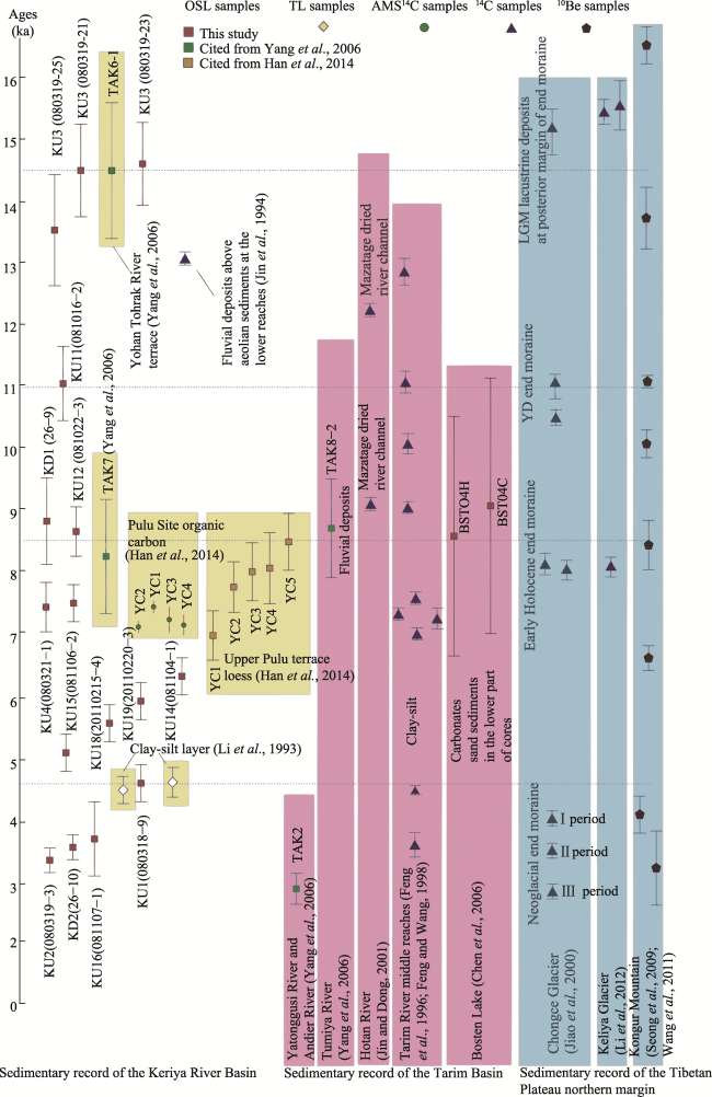
Figure 4 Plot showing the sediment ages along the Keriya River and around the Tarim Basin
The OSL ages of the river flood events in the lower reaches of the Keriya River do not correspond completely to the glacial advances and deglaciation on the periphery of the Tarim Basin. For example, accelerator mass spectrometry (AMS) 14C dating of interlayer organic matter in the section located in the Pulu Yangchang in the middle reaches of the Keriya River revealed that the loess accumulated at about 6.942-7.564 ka (Han et al., 2014), and was not eroded by the river after that. It is also possible that the river cut downward due to structural uplift, making it difficult for the later flood to affect the loess accumulation.
The environment seems to have become dry, but the OSL ages of samples from the lower reaches of the Keriya River obtained in this study show that there was still fluvial activity at (7.4±0.4) ka, (7.5±0.3) ka, (6.3±0.3) ka, (6.0±0.3) ka, (5.6±0.3) ka, and (5.28±0.25) ka. Moreover, the (4.6±0.3) ka OSL age of the KU1 terrace, the (4.48±0.22) ka and (4.74±0.24) ka thermoluminescence ages (Li et al., 1993) of the other two clay-silt deposits in the lower reaches of the Keriya River, and the (4.497±0.097) ka 14C ages (Feng et al., 1996; Feng and Wang, 1998) of the clay-silt deposits in the middle reaches of the Tarim River all imply that flooding occurred around 4.5 ka. However, there seem to be no significant glacier advances and deglaciation record in the periphery of the Tarim Basin, which may be due to the lack of chronological data or the large error of the thermoluminescence and 14C age data for the early period.

5.3 Dune formation

The formation of dunes on the delta may have been influenced by many factors, mainly wind and other factors such as the topography (Yang et al., 2011a) and fluvial activities (Bullard and McTainsh, 2003). The atmospheric circulation in the lower reaches of the Keriya River is basically uniform (Han et al., 2005), and the terrain is generally flat (Zhu et al., 1988; Li et al., 1993; Zhou et al., 1996; Jin and Dong, 2001). Fluvial activities could have been largely involved in the formation of the dunes (Jin and Dong, 2001) and may affect their construction. In the lower reaches of the Keriya River, wind erosion remnants of interbedded clay-silt and silt deposits have been identified (Figure 5), which suggests that the fluvial deposits are the provenance of the dune material (Zhu et al., 1980, 1988). Grain size measurement results for samples from the Yuansha delta also show that the fluvial deposits are mainly composed of clay silt, silt, and very fine sand, while the dune sands are generally coarse-grained and are mainly composed of silt and very fine sand (Xia et al., 2014), which suggests that the dune sands were formed by fluvial deposition and were later affected by wind sorting and transformation. The earliest OSL ages recorded by the fluvial deposits in the lower reaches of the Keriya River obtained in this study is in MIS3, which is consistent with that of the lower reaches of the Yatonggusi River and Andier River (Yang et al., 2006), so the river may have started to provide material for dune formation from this time onward.
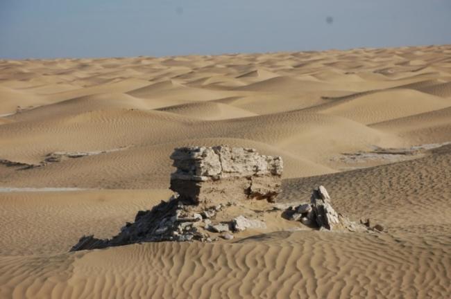
Figure 5 Photo (38°47′N, 81°35′E) showing residual a wind-eroded riverbed near Yuansha Site
Zhu et al. (1988) believed that the Keriya dry delta and the dunes west of the river were formed since the Han and Tang dynasties based on the ages of the Karadun and Dandanwulik sites. However, this conclusion may need to be reconsidered because sites with earlier ages in this area have not been reported, and chronology data for this time period are very scarce. The existence of the Beifang Cemetery, Yuansha Site and Karadun Site suggests that a desert riparian forest existed in the Keriya River delta, and the active dunes were mainly formed after river diversion and site abandonment. The dry delta was formed by fluvial accumulation and mainly developed in the Holocene. The dunes also formed during this period.
In addition, fluvial activities may also have affected the dune size. The heights of the barchan dunes and barchan dune chains in the Yuansha and Karadun deltas are relatively low, which may be the result of the absence of long-term fluvial accumulation due to the influence of river swells and washes. The development of the longitudinal sand dunes in the area between Yuansha and Karadun sites (sections KU5, KU11, and KU12) and between the Keriya River and Hotan River may be related to the shorter period of fluvial activity and the longer period of aeolian activity. Some developed relatively taller sand dunes, and their underlying sedimentary age is indeed older, such as the dunes formed on the river terrace at the end of the LGM in the Yohan Tohrak area on the east bank of the Keriya River.
Fluvial activity has had a profound impact on the development of the landscape in the Taklimakan Desert. The fluvial deposition of the Keriya River in the hinterland of the desert is related to glacier advances and deglaciation in the upper reaches of the river, which suggests that the formation of the modern geomorphic pattern of the Taklimakan Desert was controlled by climate changes.

6 Conclusions

The formation and evolution of the landforms in the hinterland of the Taklimakan Desert can be identified based on the ages of sediments from the rivers originating in the mountains surrounding the Tarim Basin, but few ideal data have been reported. We investigated the deep desert area in the lower reaches of the Keriya River in the southern margin of the Tarim Basin and collected sediment samples for OSL dating. The OSL ages were concentrated at 38-47 ka in MIS3, 14.5 ka at the end of the LGM, and 11 ka, 8-9 ka, 5-6.5 ka, 4.6 ka, and 3.4-3.7 ka in the Holocene. The exposed fluvial sediments differ in age by tens of thousands of years. The samples with Holocene ages are mainly distributed in the area between the Yuansha and Karadun dry deltas, the samples with ages in MIS3 are located close to the Hotan River, and the samples with ages in the LGM are located far away from the Keriya River. The fluvial sediments reflect river flooding, and fluvial activities affect the development of the landscape. The dunes in the dry delta in the lower reaches of the Keriya River could have formed since the Holocene. The age of the fluvial deposition corresponds to the glacial advances and deglaciation in the mountains surrounding the Tarim Basin. However, it is still difficult to link the Holocene flood activity in the Taklimakan Desert with the glacier advances and deglaciation because the previously reported 14C ages of fluvial and lacustrine deposits in the desert did not consider the reservoir effect, and there are also inconsistencies in the glacial moraine ages. The OSL method provides more reliable age data than other methods due to the well-exposed sand grains in desert environments. In particular, the deposition time of flood sediments in rivers in the deep part of the desert corresponds to the special climatic transition. Whether this is accidental or inevitable, the mechanism behind it needs to be further explored.

Acknowledgments

The authors thank Professor Yang Xiaoping of Zhejiang University and Professor Zhou Xingjia of the Xinjiang Institute of Biology and Geography, Chinese Academy of Sciences, for their suggestions. The authors thank Professor Zhao Hui of the Northwest Institute of Eco-Environment and Resources, Chinese Academy of Sciences, and Professor Zhao Hua and Engineer Wang Chengmin of the Institute of Hydrogeology and Environmental Geology, Chinese Academy of Geological Sciences, for the determination and analysis of the optically stimulated luminescence age samples.
[1]
Abdurusul Idris, Falankefu G D, Liu Guorui et al., 1998. Summaries of the archaeological investigation along the Keriya River in Xinjiang. Archaeology, (12): 28-37. (in Chinese)

[2]
Abdurusul Idris, Li Wenying, Hu Xingjun, 2012. The preliminary study of Xiaohe Graveyard. China Border Area Study, (190): 15-27. (in Chinese)

[3]
Bullard J E, McTainsh G H, 2003. Aeolian-fluvial interactions in dryland environments: Examples, concepts and Australia case study. Progress in Physical Geography, 27(4): 471-501.

[4]
Cao Qiongying, Xia Xuncheng, 1992. A preliminary study on the geomorphology and Quaternary geology in the lower reaches of the Keliya River. Scientia Geographica Sinica, 12(1): 34-43. (in Chinese)

[5]
Chang Hong, An Zhisheng, Liu Weiguo et al., 2012. Magnetostratigraphic and paleoenvironmental records for a Late Cenozoic sedimentary sequence drilled from Lop Nor in the eastern Tarim Basin. Global & Planetary Change, 80: 113-122.

[6]
Chen Fahu, Huang Xiaozhong, Yang Meilin et al., 2006. Westerly dominated Holocene climate model in arid central Asia: Case study on Bosten Lake, Xinjiang. Quaternary Sciences, 26(6): 881-887. (in Chinese)

[7]
Deevey E S, Gross M S, Hutchinson G E et al., 1954. The natural 14C contents of materials from hard-water lakes. Proceedings of the National Academy of Sciences of the United States of America, 40(5): 285-288.

PMID

[8]
Dortch J M, Owen L A, Caffee M W, 2013. Timing and climatic drivers for glaciation across semi-arid western Himalayan-Tibetan orogen. Quaternary Science Reviews, 78: 188-208.

DOI

[9]
Fang Xiaomin, Lyu Lianqing, Yang Shengli et al., 2001. Loess in Kunlun Mountains and its implications on desert development and Tibetan Plateau uplift in west China. Science in China (Series D), 45(4): 289-299. (in Chinese)

[10]
Feng Qi,Li Zhenshan, Chen Guangting, 1996. Grain size characteristics of sedimentary and the climatic change in middle reaches of Tarim River. Acta Sedimentologica Sinica, 14: 227-233. (in Chinese)

[11]
Feng Qi,Wang Jianmin, 1998. An evolution of Holocene environment in the North of Taklimakan Desert (II). Acta Sedimentologica Sinica, 16(2): 129-133. (in Chinese)

[12]
Han Wenxia, Yu Lupeng, Lai Zhongping et al., 2014. The earliest well-dated archeological site in the hyper-arid Tarim Basin and its implications for prehistoric human migration and climatic change. Quaternary Research, 82(1): 66-72.

DOI

[13]
Han Yongxiang, Fang Xiaomin, Song Lianchun et al., 2005. A study of atmospheric circulation and dust storm causes of formation in the Tarim Basin: The restructured wind field by shapes of dune and observed prevailing wind. Chinese Journal of Atmospheric Sciences, 29(4): 627-635. (in Chinese)

[14]
Huang Jingjing, Zhang Feng, Shi Qingdong et al., 2019. Variation characteristics for temperature and relative humidity of the natural oasis in the hinterland of the Taklamakan Desert for 2015-2016. Journal of Xinjiang University (Natural Science Edition), 36(3): 267-275. (in Chinese)

[15]
Jiao Keqin, Yao Tandong, Li Shijie, 2000. Evolution of glaciers and environment in the West Kunlun Mountains during the Past 32 ka. Journal of Glaciology and Geocryology, 22(3): 250-256. (in Chinese)

[16]
Jin Heling, Dong Guangrong, 2001. Preliminary study on the role of river wriggling in the evolution of aeolian landforms in arid region: Taking Hotan River as an example. Journal of Desert Research, 21(4): 367-373. (in Chinese)

[17]
Jin Heling, Dong Guangrong, Jin Jiong, 1994. Environmental and climatic changes in the interior of Taklimakan Desert since Late Glacial Age. Journal of Desert Research, 14(3): 31-37. (in Chinese)

[18]
Lai Zhongping, Ou Xianjiao, 2013. Basic procedures of optically stimulated luminescence (OSL) dating. Progress in Geography, 32(5): 683-693. (in Chinese)

DOI

[19]
Li Baosheng, David Dian ZHANG, Zhou Xingjia et al., 2002. Study of sediments in the Yutian-Hotan Oasis, South Xinjiang, China. Acta Geologica Sinica, 76(2): 287. (in Chinese)

[20]
Li Baosheng, Dong Guangrong, Zhu Yizhi et al., 1993. The sedimentary environment and evolution of the loess and desert in the Tarim Basin since the Last Glaciation. Science in China (Series B), 23(6): 644-651. (in Chinese)

[21]
Li Baosheng, Wen Xiaohao, Zhang David Dian et al., 2008a. Millennial-scale climate fluctuations during the last interstadial recorded in the AQS3 segment of the Aqiang Loess section in the north piedmont of the Kunlun Mountains. Quaternary Sciences, 28(1): 140-149. (in Chinese)

[22]
Li Bingyuan, 2000. The last greatest lakes on the Xizang (Tibetan) Plateau. Acta Geographica Sinica, 67(2): 174-182. (in Chinese)

[23]
Li Shijie, Chen Wei, Jiang Yongjian et al., 2012. Geological records for Holocene climatic and environmental changes derived glacial, periglacial and lake sediments on Qinghai-Tibetan Plateau. Quaternary Sciences, 32(1): 151- 157. (in Chinese)

[24]
Li Shijie, Zhang Hongliang, Shi Yafeng et al., 2008b. A high resolution MIS 3 environmental change record derived from lacustrine deposit of Tianshuihai Lake, Qinghai-Tibet Plateau. Quaternary Sciences, 28(1): 122-131. (in Chinese)

[25]
Lu Yanchou, Zhang Jingzhao, Zhao Hua, 1991. Paleodose determination methods of TL dating of the Quaternary sediments. Nuclear Techniques, 14(2): 109-113. (in Chinese)

[26]
Mayewski P A, Rohling E E, Curt Stager J et al., 2004. Holocene climate variability. Quaternary Research, 62(3): 243-255.

DOI

[27]
Owen L A, Kamp U, Spencer J Q et al., 2002. Timing and style of Late Quaternary glaciation in the eastern Hindu Kush, Chitral, northern Pakistan: A review and revision of the glacial chronology based on new optically stimulated luminescence dating. Quaternary International, 97: 41-55.

[28]
Prescott J R, Hutton J T, 1994. Cosmic ray contributions to dose rates for luminescence and ESR dating: Large depths and long-term time variations. Radiation Measurements, 23(2/3): 497-500.

DOI

[29]
Prescott J R, Robertson G B, 1997. Sediment dating by luminescence: A review. Radiation Measurements, 27(5/6): 893-922.

DOI

[30]
Seong Y B, Owen L A, Yi C et al., 2009. Quaternary glaciation of Muztag Ata and Kongur Shan: Evidence for glacier response to rapid climate changes throughout the Late Glacial and Holocene in westernmost Tibet. Geological Society of America Bulletin, 121(3/4): 348-365.

DOI

[31]
Shen Yongping, Ding Yongjian, Liu Shiyin et al., 2004. An increasing glacial lake outburst flood in Yarkant River, Karakorum in past ten years. Journal of Glaciology and Geocryology, 26(2): 234. (in Chinese)

[32]
Shi Qingdong, Guo Yuchuan, Zhou Xiaolong et al., 2019. Mechanism of the influence of surface water and groundwater on vegetation pattern in Daliyaboyi oasis at the tail of Keriya River in Taklamakan Desert. Journal of Xinjiang University (Natural Science Edition), 36(3): 253-259, 286. (in Chinese)

[33]
Shi Yafeng, Zheng Benxing, Yao Tandong, 1997. Glaciers and environments during the Last Glacial Maximum (LGM) on the Tibetan Plateau. Journal of Glaciology and Geocryology, 19(2): 97-113. (in Chinese)

[34]
Stokes S, Bailey R M, Fedoroff N et al., 2004. Optical dating of aeolian dynamism on the west African Sahelian margin. Geomorphology, 59(1/4): 281-291.

DOI

[35]
Sun Jimin, Liu Tungsheng, 2006. The age of the Taklimakan Desert. Science, 312(5780): 1621.

PMID

[36]
Wang Jie, Zhou Shangzhe, Zhao Jingdong et al., 2011. Quaternary glacial geomorphology and glaciations of Kongur Mountain, eastern Pamer, China. Science China: Earth Sciences, 54(4): 591-602. (in Chinese)

DOI

[37]
Wen Kang, 1988. Taklamakan Desert comprehensive examination team completed investigation at the Keriya River downstream. Arid Zone Research, (4): 46. (in Chinese)

[38]
Xia Qianqian, Ma Jiaju, Zhang Feng, 2014. The grain size parameters measurment of sediment at the Yuansha Delta in Central Taklimakan Desert. Journal of Xinjiang University (Natural Science Edition), 31(1): 12-16, 127. (in Chinese)

[39]
Xia Qianqian, Zhang Feng, 2016. AMS 14C dating and related historical geography question proposal at the Yuansha Delta in the central Taklamakan Desert. Quaternary Sciences, 36(5): 1280-1292. (in Chinese)

[40]
Yang Xiaoping, 2000. Loess deposits in the surrounding mountains of Tarim Basin, Northwestern China. Arid Zone Research, 23(1): 13-18. (in Chinese)

[41]
Yang Xiaoping, 2001. The relationship between oases evolution and natural as well as human factors: Evidences from the lower reaches of the Keriya River, southern Xinjiang, China. Earth Science Frontiers, 8(1): 83-89. (in Chinese)

[42]
Yang Xiaoping, Preusser F, Radtke U, 2006. Late Quaternary environmental changes in the Taklamakan Desert, western China, inferred from OSL-dated lacustrine and aeolian deposits. Quaternary Science Reviews, 25(9): 923-932.

DOI

[43]
Yang Xiaoping, Scuderi L, Liu Tao et al., 2011a. Formation of the highest sand dunes on Earth. Geomorphology, 135(1/2): 108-116.

DOI

[44]
Yang Xiaoping, Scuderi L, Paillou P et al., 2011b. Quaternary environmental changes in the drylands of China: A critical review. Quaternary Science Reviews, 30(23): 3219-3233.

DOI

[45]
Yang Xiaoping, Zhu Zhenda, Jaekel D et al., 2002. Late Quaternary palaeoenvironment change and landscape evolution along the Keriya River, Xinjiang, China: The relationship between high mountain glaciation and landscape evolution in foreland desert regions. Quaternary International, 97: 155-166.

[46]
Yang Yichou, 1990. Formation and evolution on Keriya River landforms. Arid Land Geography, 13(1): 37-45. (in Chinese)

[47]
Yang Youlin, 1986. Scientists from China and the Federal Republic of Germany jointly visited the Taklamakan Desert. Journal of Desert Research, 6 (4): 72-73. (in Chinese)

[48]
Zhang Feng, Wang Tao, Yimit Hamid et al., 2011. Hydrological changes and settlement migrations in the Keriya River delta in central Tarim Basin ca. 2.7-1.6 ka B.P.: Inferred from 14C and OSL chronology. Science China: Earth Sciences, 54(12): 1971-1980. (in Chinese)

DOI

[49]
Zhang Keqi, Wu Zhonghai, Lyu Tongyan et al., 2015. Review and progress of OSL dating. Geological Bulletin of China, 34(1): 183-203. (in Chinese)

[50]
Zhao Hua, Lu Yanchou, Wang Chengmin et al., 2011. A review of OSL dating for water-laid deposits: progress and prospect. Nuclear Techniques, 34(2): 82-86. (in Chinese)

[51]
Zhao Jingdong, Liu Shiyin, Wang Jie et al., 2009. Glacial advances and ESR chronology of the Pochengzi Glaciation, Tianshan Mountains, China. Science in China (Series D), 53(3): 403-410. (in Chinese)

DOI

[52]
Zheng Hongbo, Wei Xiaochun, Tada R et al., 2015. Late Oligocene-early Miocene birth of the Taklimakan Desert. Proceedings of the National Academy of Sciences of the United States of America, 112(25): 7662-7667.

DOI PMID

[53]
Zhou Xingjia, 1991. Textual research on the matter of the Keriya River flowed into the Tarim River//Xinjiang Keriya River and the Taklamakan Desert Scientific Expedition Team. The Report of Scientific Exploration and Investigation in the Keriya River Valley and the Taklamakan Desert. Beijing: China Science and Technology Publishing House, 40-46. (in Chinese)

[54]
Zhou Xingjia, Li Baosheng, Zhu Feng et al., 1996. The research on the development and evolution of the oasis of Keriya River in the Tarim Basin of Xinjiang. Yunnan Geographic Environment Research, 8(2): 44-57. (in Chinese)

[55]
Zhou Xingjia, Zhu Feng, Li Shiquan, 1994. The formation and evolution of oasis in the Keriya River Valley. Quaternary Sciences, (3): 249-255. (in Chinese)

[56]
Zhu Bingqi, Yu Jingjie, Qin Xiaoguang et al., 2013. Formation and evolution of sandy deserts in Xinjiang: The palaeo-environmental evidences. Acta Geographica Sinica, 68(5): 661-679. (in Chinese)

[57]
Zhu Zhenda, Chen Zhiping, Wu Zheng et al., 1981. Study on the Aeolian Geomorphology in the Taklimakan Desert. Beijing: Science Press. (in Chinese)

[58]
Zhu Zhenda, Lu Jinhua, Jiang Weizheng, 1988. Study on formation and development of aeolian landform and trend of environmental change at lower reach of the Keriya River, Taklimakan Desert. Journal of Desert Research, 8(2): 1-10. (in Chinese)

[59]
Zhu Zhenda, Wu Zheng, Liu Shu et al., 1980. Introduction to the Deserts in China. rev. ed. Beijing: Science Press. (in Chinese)

Outlines

/