Research Articles

Socio-economic roots of human settlement layout in the marginal zone of the Changtang Plateau uninhabited area:A comparative study of three typical counties

  • ZHANG Haipeng , 1, 2 ,
  • LIU Weidong , 1, 2, * ,
  • LIU Zhigao 1, 2 ,
  • CHENG Han 1 ,
  • LIU Hanchu 3
Expand
  • 1. Key Laboratory of Regional Sustainable Development Modeling, Institute of Geographic Sciences and Natural Resources Research, CAS, Beijing 100101, China
  • 2. College of Resources and Environment, University of Chinese Academy of Sciences, Beijing 100049, China
  • 3. Institutes of Science and Development, CAS, Beijing 100190, China
*Liu Weidong (1967-), PhD and Professor, specialized in economic geography, regional development and the Belt and Road Initiative studies. E-mail:

Zhang Haipeng (1992-), PhD Candidate, specialized in economic geography and regional studies. E-mail:

Received date: 2022-04-14

  Accepted date: 2022-08-29

  Online published: 2023-03-21

Supported by

The Second Comprehensive Scientific Investigation and Research Project of the Qinghai-Tibet Plateau(2019QZKK1007)

The Strategic Priority Research Program of the Chinese Academy of Sciences(XDA20010102)

Abstract

Human activities in the marginal zone of the Changtang Plateau (CTP) uninhabited area are important research topics in China and globally. Based on the core-periphery theory of geography, this paper selected three counties in the marginal zone of the CTP uninhabited area with significant transitional physical geography features and socio-economic conditions as case areas. We used the data set of settlement patches identified by visual interpretation in Google Earth Pro, combining them with field survey data to study the evolution of human settlements on the CTP, the characteristics of settlement layout, and their socio-economic roots. The study found that: (1) Since the democratic reform in Tibet, the production mode of herders on the CTP has transitioned from four-season nomadic herding to cold-season sedentary grazing, warm-season rotational grazing, and then to a combination of sedentary grazing and forage supplementation. In structural changes of grassroots organizations, village boundaries were clarified, grazing ranges were fixed, and settlement systems were formed. (2) On a large scale, the settlement layout on the CTP showed a certain degree of agglomeration in local areas, but the settlements’ spatial agglomeration decreased as the observation scale decreased. The settlement size structure matched the typical rank-size rule of rural settlements. (3) The settlement layout of the CTP showed significant traffic lines and dominant location orientation. These orientation characteristics revealed “core-periphery” regional differences. Changes in production conditions, such as artificial grass cultivation and part-time employment, affected the dependence on traditional grazing points. Settlements moved from resource dependence to dependence on multiple elements, such as resources and facilities. The religious, cultural heritage of the sacred mountains, lakes, and temples influenced the settlement layout, leading to clustering in local areas and to group format. This study expands our understanding of the settlement pattern in the marginal zone of uninhabited areas and provides valuable references for advancing the optimization of the CTP human settlement system in the new era.

Cite this article

ZHANG Haipeng , LIU Weidong , LIU Zhigao , CHENG Han , LIU Hanchu . Socio-economic roots of human settlement layout in the marginal zone of the Changtang Plateau uninhabited area:A comparative study of three typical counties[J]. Journal of Geographical Sciences, 2023 , 33(3) : 655 -680 . DOI: 10.1007/s11442-023-2100-3

1 Introduction

The formation and evolution of human settlement patterns are influenced by the natural environment and socio-economic conditions (Li et al., 2019). Their degree of influence on the settlement layout differs for different geographical environments and productivity levels. At low productivity levels, the natural environment plays a dominant role in the siting of settlements. While its influence decreases due to its temporal stability (Zhou et al., 2013). On long time scales, socio-economic systems are usually in constant change, and their impact on settlement patterns is dynamic and increasing in intensity (Tang et al., 2018). China’s vast territory is divided into three levels of terrain in terms of geographical conditions, agricultural and pastoral areas in terms of production methods, and in line with 56 ethnic groups in terms of human landscape. Different ethnic groups have different living customs and cultural characteristics. These objective circumstances determine that the settlement patterns of different regions, and their formation mechanisms have specific regional genes (Li et al., 2018). The interaction of internal and external development factors in the new era of industrialization, urbanization, and economic globalization has caused drastic adjustments to the socio-economic system of the Chinese countryside, profoundly affecting the evolution of the settlement pattern (Yang et al., 2019). This is especially true for the remote mountainous and plateau areas in China. Its human settlement pattern has adapted to the local natural geographical conditions during the long-term survival. Meanwhile, the long-lagging socio-economic system is undergoing a drastic evolution in the new development period, becoming the most active force influencing the layout of settlements in these regions. However, existing settlement studies indicate the limitation of settlement study cases for specific natural and human landscape areas in terms of case selection. In the exploration of the factors influencing settlement layout, increasing attention has been paid to the role of the socio-economic system (Zhang et al., 2019; Luo et al., 2021). However, the research usually focuses on conventional factors. Special factors reflecting regional characteristics, such as pastoral production methods, ethnic culture, and religious customs, need to be addressed. The study of regional geography requires the selection of key regions with global value and regional characteristics in line with the strategic needs of national development (Zhao and Li, 2019). The study of distinctive development elements affecting settlement patterns helps identify the geographical genes of the human-land relationship in unique regions.
The Qinghai-Tibet Plateau (QTP) is one of the most distinctive natural and cultural plateaus in the world. It is known as the Third Pole of the earth (Fan and Wang, 2005). The Changtang Plateau (CTP), as an important part of the Third Pole, is located in the northern hinterland of the QTP. It is one of the world’s 10 most uninhabited areas and one of the most sparsely populated and economically underdeveloped regions in China (Allan et al., 2017). It consists mainly of the Changtang National Nature Reserve, an interfacial transition zone between human activities and the wilderness (Zhang et al., 2022). Since the 1970s, the population and livestock numbers in the southern part of the CTP have grown, and herding activities have moved into the uninhabited area (Xu et al., 2018). Historically, the herders of the CTP lived a nomadic life based on water and grass, and there were no villages. Since the 1980s, the government has implemented pasture contracting and settlement projects. By 2015, more than 2 million rural people in Tibet had left their nomadic way of living and had adopted a settled life (Xu et al., 2017; Zhang et al., 2019). In addition, the opening of the Qinghai-Tibet Railway in 2006 and the modernization process caused the northern Tibetan Plateau to enter a new stage of open development. The socio-economic system experienced profound changes (Yi et al., 2020). As an extremely sparsely populated area, a geographic transition zone, an alpine pastoral area, a national nature reserve and a lagging socio-economic system area, combined with the transformation of herders from nomadic herding to sedentary grazing and the changes in the socio-economic system in recent years, the special geographical environment, and the development characteristics of the CTP determine the typicality and uniqueness of its human settlement characteristics. Research on the characteristics of settlement layout and its socio-economic roots in such unique areas can not only add valuable cases to the existing settlement research system and expand people’s understanding of settlement patterns in the marginal zone of uninhabited areas, but also has important practical significance for optimizing the pattern of human activities on the CTP and protecting the fragile wilderness ecosystem.
The special geographical environment makes the QTP and CTP a hot spot for academic research (Farrington and Tsering, 2019; Yang et al., 2019). However, the focus of research has long been on the natural environment, including permafrost, glaciers, alpine meadows, and wildlife conservation (Yin et al., 2017; Xue et al., 2018; Xu et al., 2020). As modernization progresses, human activities on the QTP and their coupling with ecological and socio-economic conditions are in a dynamic process of evolution (Fernanda et al., 2017; Xu et al., 2018). Scholars have used remote sensing image machine interpretation, nighttime light indices, spatial gridding of population data, and big data on a large scale to assess and simulate the human footprint on the QTP (Yang et al., 2019; Sun et al., 2020; Yi et al., 2020). The related results provide a useful reference for understanding the macroscopic pattern of human activities on the QTP. However, the QTP is vast, and the CTP in northern Tibet has harsh natural conditions and a small extremely sparsely distributed population. In addition, it is a purely pastoral area (Zhang et al., 2019). Research tools, like machine interpretation of remote sensing images, nighttime light indices, and big data can portray human settlement characteristics in densely populated areas, but inevitably result in incomplete and inaccurate spatial portrayal of human activity ranges and settlements in sparsely populated areas. This is chiefly why few current settlement studies have addressed sparsely populated areas such as the CTP.
Based on the above research status, this paper selected three counties in the marginal zone of CTP uninhabited area as the case areas from the perspective of the core-periphery theory of geography. It combines the dataset of settlements patches identified by visual interpretation in Google Earth Pro high-precision remote sensing images with field survey data, in order to study the layout characteristics and its socio-economic roots of human settlements on the CTP. The objectives of this paper are: (1) to summarize and categorize the changes in pastoral social systems and the development of settlements in the northern Tibetan Plateau; (2) to characterize the pattern of human settlements in the marginal zone of CTP uninhabited area, and to analyze and compare the state of settlement concentration and size level characteristics of different counties; (3) to analyze the socio-economic roots of human settlement layout on the CTP in four dimensions, respectively transportation, location, traditional production conditions and religion and culture. The intrinsic mechanisms are also analyzed.

2 Materials and methods

2.1 Research framework

The CTP possesses natural-human interactive coupling characteristics such as the typicality of the natural environment, closed geographical space, fragility of the ecosystem, and marginality of the socio-economic system. Based on the unique global significance of the marginal zone of the CTP uninhabited area, the following three counties with typical hierarchical structures and gradient characteristics were selected for this research: the core area-Nagqu County (NQC), the semi-periphery area-Nyima County (NMC) and the periphery area-Shuanghu County (SHC). The counties were selected as case sites from the perspective of the core-periphery theory of geography and the CTP socio-economic system. Based on the literature, we have comprehensively reviewed the history of social system changes and settlements development in northern Tibet, exploring the distribution of settlements in the three counties at the county, township, and village scales with the nearest neighbor index. We examined the size distribution characteristics of the settlement system using the mean of the rank-size rule. Since we have already focused on the influence of natural environmental conditions on settlement patterns in northern Tibet, and the Changtang Plateau has experienced more significant socio-economic development in recent years, socio-economic factors have become an active force influencing the formation of settlement patterns. Therefore, this paper focuses on the socio-economic roots of the formation of the settlement pattern on the Changtang Plateau. In this context, we also selected the three-level road system of national highway, provincial highway, and county highway to characterize the transportation conditions; the three-level administrative centers of county center, township center, and administrative village to characterize the locational conditions; the traditional summer and winter grazing sites to represent the pastoral production conditions; and the layout of religious temples to characterize the religious-cultural characteristics. The influence of the above four types of elements on the spatial layout of the CTP settlement system was investigated using a comprehensive geostatistical analysis. This study aims to reveal the patterns of human-land relationships and their regional differences in particular regions and at special development stages (Figure 1), and to provide references for the interpretation of strategies and paths of settlement optimization under different development patterns.
Figure 1 Analytical framework

2.2 Study area

The study area of this paper includes NQC, NMC, and SHC on the CTP, all of which belong to Nagqu City, Tibet Autonomous Region (Figure 2). Table 1 presents a basic overview of the three counties in the study area. It should be noted that NQC, the seat of Nagqu Municipal Government, was renamed Saini District in 2017. However, as the name Nagqu in northern Tibet has been used historically and is more generalized, this paper uses NQC to refer to Saini District to improve the dissemination of research content.
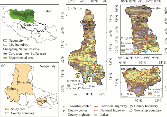
Figure 2 Location of the study area (Nagqu County, Nyima County and Shuanghu County)
Table 1 Comparison of the basic situation of the three counties in the Changtang Plateau
County
name
Area
(thousand km2)
Number of townships Number of
administrative
villages
Rural per capita
disposable income (thousand yuan)
Population
(thousand)
Settlements
area (km2)
NQC 16.20 12 141 14.30 112.95 75.94
NMC 72.50 14 77 13.99 34.92 9.29
SHC 116.64 7 31 11.82 14.50 3.82
County
name
Population density (person/km2) Average
patch area (ha)
Lowest
altitude (m)
Geographic
location
Location conditions
NQC 6.97 2.60 4260 Marginal zone of CTP Prefectural government location
NMC 0.48 0.40 4537 Hinterland of CTP Marginal zone of uninhabited area
SHC 0.12 0.68 4585 Hinterland of CTP Marginal zone of uninhabited area

Note: The socio-economic data in the table are for 2020.

In this paper, a comparative study of NQC, NMC and SHC shows the following characteristics. (1) All three counties are located in the northern Tibetan Plateau; NMC and SHC are located in the hinterland of the CTP; NQC is located in the marginal zone of the CTP; all three counties are pure pastoral counties; all can be used as typical representatives of the alpine pastoral area of the CTP. (2) There are obvious transitional changes in the physical geographic conditions of the three counties. Moving from NQC to NMC and then to SHC is the process of further harsh changes in natural environmental conditions, and the process of constantly approaching the uninhabited area of CTP. Among the countries, NQC does not have uninhabited area. NMC and SHC are vertically distributed from north to south, and their northern parts are vast uninhabited area of the CTP. SHC is at a higher latitude and has a larger uninhabited area (Figure 2). (3) The development level of the socio-economic systems in the three counties has a significant core-periphery structure. From NQC to NMC to SHC, there is a gradient transition process from the core to the semi-periphery and then to the periphery. NQC, as the prefectural government location, has relatively developed socio-economic system and is the center of Nagqu City. NMC is the gateway to Ali in Nagqu City. The National Highway 317 passes through the county. The south of the county has a relatively superior natural geographic environment with human settlements resulting in a certain degree of clustering of economic factors. SHC has a harsh natural environment, an extremely sparse population, and a poorly developed economic system. The existence of the characteristics mentioned above of the three counties is conducive to the horizontal comparison of the commonalities and characteristics of the layout of human settlements and their socio-economic roots in the marginal zone of the CTP uninhabited area. Such a comparison also reveals regional differences in the patterns of human-land relationship in the exceptional geographical environment.

2.3 Data sources

The data involved in this study mainly include settlement patches, geographic elements, socio-economic data, and field survey data. (1) Settlement patches dataset. The settlements in northern Tibetan pastoral areas comprise pastoral production and living arrangements. They are generally enclosed in courtyards with production facilities such as livestock stalls, grass storage sheds, warming sheds and lambing shed, and living spaces such as living rooms, kitchens, and storage rooms. The boundaries of the courtyards can be clearly identified in the high-definition remote sensing images (Zhang et al., 2022). Combined with the realistic understanding of the distribution of settlements in northern Tibet during the field research, we divided the study area into equally spaced longitudinal and latitudinal grids and numbered them by using the high-resolution remote sensing images in Google Earth Pro, and sketched out the settlement patches by visually interpreting the grids one by one. We also verified the settlement patches data with image data acquired by China’s Resource 302 satellite to ensure the accuracy of the data. This resulted in a sub-village-courtyard-scale settlement patches dataset for the study area in 2017. (2) Geographical elements and socio-economic data. We obtained digital elevation data at 30 m resolution from the geospatial data cloud platform (http://www.gscloud.cn/sources/), data on the extent of administrative boundaries of various levels, the extent of nature reserves and lakes from the Resource and Environment Science and Data Center of the Chinese Academy of Sciences (https://www.resdc.cn/), data on the distribution of different levels of roads and temples from the website of the Natural Resources Department of Tibet Autonomous Region (http://zrzyt.xizang.gov.cn/fw/zyxz/). The data on grazing points were obtained from the Tibet Autonomous Region Atlas. Other socio-economic data were obtained from the Tibet Autonomous Region Statistical Yearbook and the China County Statistical Yearbook. (3) Field survey data. We conducted fieldwork twice in July 2018 and August 2020, in the three counties of Nagqu City. We obtained rich research materials on the development of settlement systems in northern Tibet during discussions with government departments, interviews with resident village cadres, field visits and household surveys.

2.4 Research methods

2.4.1 Average nearest neighbor index

The average nearest neighbor index is an effective method to quantitatively measure the spatial distribution of cluster and sparsity. The basic principle is to compare the distance between the center of a cluster and its nearest neighbor with the average distance expected by a hypothetical random distribution, and then determine its sparsity status, and the formula is:
$\text{ANN}=\frac{{{{\bar{D}}}_{0}}}{\bar{D}e}=\frac{\mathop{\sum }_{i}{{d}_{i}}/n}{\sqrt{n/A}/2}=\frac{2\sqrt{\gamma }}{n}\underset{i}{\mathop \sum }\,{{d}_{i}}$
where ${{\bar{D}}_{0}}$ is the average distance between the two closest settlements; ${{\bar{D}}_{e}}$ is the average distance between the two settlements under the assumption of random distribution; n is the total number of settlements; d is the distance between settlements; A is the area of the study area. If ANN=1, the settlement pattern is random; if ANN>1, the settlement pattern is discrete; if ANN<1, the settlement pattern is an agglomeration. In this paper, the average nearest neighbor index is used to explore the spatial distribution of settlements in the three counties at three levels: county, township and administrative village.

2.4.2 Rank-size rule

The rank-size rule is a research method used to examine the size distribution of the settlements system from the size and rank-order relationship of the settlements, and Sonis’s study on rural settlements confirmed that the size rank distribution of rural settlements obeyed the negative exponential characteristics (Sonis and Grossman, 1984). The formulas are.
$\ln {{L}_{i}}=\ln {{L}_{1}}+(i-1)\text{ln}\delta $
$\ln {{L}_{i}}=-a{{R}_{i}}+b$
where L1 is the size of the first rural settlements, Li is the size of a rural settlements with rank i, δ=Li+1/Li is the change rate of the size of the adjacent settlements, Ri is the rank of the ith settlements, b is the intercept of the fitting line, and the goodness of fit R2 is used to indicate the degree to which the rank-size characteristics of rural settlements conform to a negative exponential distribution. The smaller the slope a, the more balanced the settlements size distribution; the smaller the intercept b, the smaller the first settlements size.

3 Results

3.1 The evolution of human settlements on the CTP

The forms of social organization and pasture management patterns in northern Tibet and the development of settlements have evolved in parallel and promoted each other (Table 2). Historically, there were no villages in the northern Tibetan pastoral areas. Before the democratic reform in Tibet, the social organization of pastoral areas was part of the feudal tribal relationship. Herders lived a nomadic life in tents near water and grass (Lang and Zhao, 2013). After the democratic reform in Tibet, mutual aid groups became autonomous social organizations at the grassroots level, and in the short term, there were no significant changes in herders’ way of life and residence patterns. In the 1970s, the People’s Commune Movement was vigorously implemented. Production groups became grass-roots organizations, and herders’ housing patterns evolved into adobe or stone-and-wood houses, no longer frequently mobile and marking the start of the semi-settlement stage (Lang and Zhao, 2010). In the 1980s, when pasture contracting began in northern Tibet, natural and administrative villages become grassroots organizations, and settlements became the norm. In 1994, the Tibet Autonomous Region issued and implemented the Grassland Law of the People’s Republic of China, which clarified the boundaries of the collective use of grassland and gradually shaped the villages according to the means of production (Lang et al., 2013). In 2001, the Tibet Autonomous Region began to implement the nomadic herders’ settlement project, whereby herders carried out production in the form of settled grazing with additional forage supplementation. Settlement and concentration became the main characteristics of the evolution of pastoral communities (Xu et al., 2017). From 2010 to 2015, the central and local governments increased their financial investment in the herders’ settlement project. The housing function of herders’ settlements on the CTP was increasingly improved, basically the settlement of all people was realized, and the settlements pattern was basically formed (Zhang et al., 2019). The production methods of the CTP herders were transformed from four-season nomadic herding to cold-season sedentary feeding, warm-season rotational grazing, and sedentary grazing with additional supplemental forage feeding. The form of herders’ dwellings changed from tents to fixed houses to courtyards with various functions. The settlement form also changed from a semi-settlement pattern to a village pattern. The grassroots social organization evolved from mutual aid groups to production teams (production groups) and then to administrative villages (natural villages). In the promotion of grass-roots administrative construction, village boundaries were gradually stablished, grazing ranges were gradually defined, and the settlement system in alpine pastoral areas gradually took shape.
Table 2 Pastoral social system and settlement development changes on the Changtang Plateau
Time Lifestyle Residence style Forms of social organization Settlement forms
Before the 1960s Semi-sedentary grazing or seasonal nomadic grazing Tents Feudal tribal relations Seasonal nomadic herding near water and grass combined with winter settlement and a dual settlement model combining settlement and mobility
After the democratic reform in Tibet Semi-sedentary grazing or seasonal nomadic grazing Tents Mutual aid groups became autonomous grassroots production organizations without village boundaries. A new collective identity was formed among mutual aid group members Nomadic by season, with settlement in winter and spring, semi-settlement, no village
The People’s Commune Movement in the 1970s Settling down and building houses with a relatively fixed grazing area, herders cannot graze beyond the territorial space of the production team or production group Small stone or adobe houses Mutual aid groups are changed to production groups under production teams, which belong to collective organizations and communes belong to higher-level administrative bodies Changes in social organization have begun to clarify the administrative, territorial and collective boundaries of grassroots organizations in pastoral areas, herders no longer move frequently, and semi-settlement
In the 1980s, the contracting of pasture was implemented in northern Tibet, and the establishment of townships was restored in 1984 in the northern Tibetan pastoral areas Grazing within a fixed range, herders’ awareness of the boundaries of grazing has increased Houses In the northern Tibetan pastoral areas, township-level structures were restored, production teams became administrative villages, and production groups became natural villages Settlement become the norm, and village prototypes gradually take shape
In 1994, the Tibet Autonomous Region issued and implemented the Grassland Law of the People’s Republic of China The boundaries of collective use of pasture are clearly defined, and natural villages are the smallest collective organizations Houses Natural villages and administrative villages The fixation of the means of production fixed the form of the village, and the determination of the right to use pasture had a propulsive significance for the formation of natural villages
In 2001, the Tibet Autonomous Region began to implement the nomadic settlement project Poverty alleviation and relocation, ecological migration, nomadic settlement policy began to be implemented, additional supplemental feeding for settled grazing Progressive diversification of housing functions Natural villages and administrative villages Housing, animal sheds, haylofts, etc.
From 2010 to 2015, the country vigorously implemented the nomadic settlement project Central financial subsidies for the autonomous regions and various funds to aid Tibet vigorously promote the settlement of herders, settled grazing, the proportion of forage supplementation increased Housing features are getting better Natural villages and administrative villages Housing, barns, haylofts, lambing shed, warming sheds and other facilities are constantly being improved

3.2 Settlement distribution characteristics

3.2.1 Spatial clustering state of settlements

The layout of human settlements on the CTP shows a certain degree of agglomeration in local areas on a large scale. The ANN index gradually increases as the observation scale decreases, indicating that the spatial agglomeration state of settlements gradually decreases, as, county > township > administrative village (Table 3 and Figure 3). In the comparison of the three counties, the ANN index of NMC at the county scale is 0.34, and the ANN index at the township scale is 0.42, both of which are the smallest results among the three counties. The ANN index of NQC is the second largest, and the ANN index of SHC is the largest, indicating that NMC has the highest degree of agglomeration in terms of the geographical space in which it is located. However, the average observed distance, at the county level, is 540.95 m in NQC, 918.06 m in NMC, and 1986.32 m in SHC. At the township level, it is 577.02 m in NQC, 1033.45 m in NMC, and 2797.91 m in SHC. At the county scale and township scale, the average observed distance in NQC is significantly smaller than that in NMC and SHC, indicating that the clusters in NQC are closer to each other and that the density of clusters is greater.
Table 3 Spatial agglomeration state of clusters at county and township levels
Study area County level Township level
Observed mean distance (m) Expected mean distance (m) ANN Observed mean distance (m) Expected mean distance (m) ANN
NQC 540.95 1424.71 0.38 577.02 1166.94 0.50
NMC 918.06 2683.51 0.34 1033.45 2368.56 0.42
SHC 1986.32 5083.16 0.39 2797.91 4430.44 0.61
Figure 3 Spatial agglomeration status of settlements at village scale
The ANN index at the administrative village level can effectively reflect the clustering characteristics of different counties in the study area at the microscopic scale (Figure 3). We calculated the ANN indices of clustered patches of administrative villages in three counties. Of the 141 administrative villages in NQC, 74 passed the 1% significance level test, with 49 having clustering status, accounting for 66.22%; 25 had in discrete status, accounting for 33.78%. Among the 77 administrative villages in NMC, 50 passed the 1% significance level test, with 46 having clustering status, accounting for 92%, and only four in dispersion. In contrast, only 10 of the 31 administrative villages in SHC passed the 1% significance level test, with six in the clustered state and four in the discrete state. The calculation results reflect that the village scale settlement layout of the CTP shows clustering and dispersion, indicating that the ANN index at the village scale can further reveal the local dispersion characteristics under the overall clustering state. Among the three villages, NMC has the highest level of agglomeration at the village scale, and almost half of the administrative villages in SHC have a discrete agglomeration layout.

3.2.2 The size distribution characteristics of the settlements

The distribution of settlements size in the three counties of the study area conforms to the typical rank-size rule. Most of the settlement patches in the three counties fell on the fitted curve (Figure 4). The goodness of fit was above 0.85 in all counties, indicating that the curve had a good degree of fit to the settlement size distribution in the study area. The settlement system of each county has a state of “raised head” and “truncated tail”. In the head settlement size characteristics, the size of high-ranking order settlements in NQC differs to a small extent between grades and shows the characteristics of continuous change, indicating that the size of high-ranking settlements in NQC shows a gradient change. In contrast, the gap between the head settlement sizes of NMC and SHC is relatively large, showing discontinuous intermittent changes, indicating that the county town and township seat patches of NMC and SHC show the characteristics of a dominant family. Comparing the rank-size curves of the three counties (Figure 4d), we found that the slope of SHC is significantly larger than that of NQC and NMC, indicating that the settlement size system of the former is more concentrated, while the latter is relatively balanced. From the intercept distance, NQC is significantly larger than NMC and SHC, indicating that the county town size of NQC is much larger than the sizes of NMC and SHC.
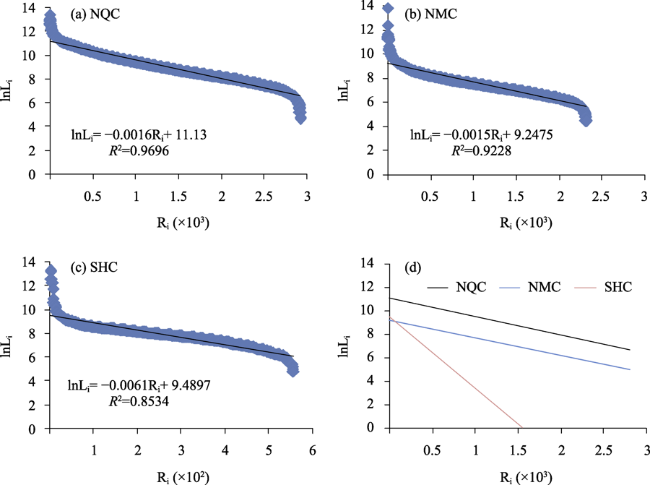
Figure 4 Rank-size distribution characteristics of settlement systems in three counties

3.3 Analysis of the influencing factors of settlement layout

3.3.1 Traffic conditions

The circulation characteristics of roads facilitate the movement of people, materials, and information between regions, the connection between peripheral areas and central areas, and the cultural interaction between different ethnic groups. Roads profoundly affect the layout of human settlements and changes in socio-economic systems (Tian and Ma, 2020). There are significant differences in the degree of access to external links and the degree of influence on the layout of human settlements among different levels of roads (Wu et al., 2013). Therefore, this paper explores the influence of national, provincial, and county highways on the settlement layout of the three counties in the study area.
The settlement layout of the study area has significant road proximity characteristics, and is more strongly influenced by high-grade roads in counties with high levels of economic development. However, while the significant influence of low-grade roads on settlement layout occurs in counties with low economic levels (Figure 5). The settlement layout of NQC shows the strongest proximity to the national highway, with more than half of the county’s settlement area distributed within 4 km of the national highway. The settlement area share of NMC and SHC is only 17.82% and 2.75% under the same circumstances. The settlements layout of SHC has the strongest provincial highway proximity, with nearly 70% of the county’s settlements area distributed within 8 km on both sides of the provincial highway. Under the same conditions, the settlement share of NMC is 43.3%, while that of NQC is only 12.69%. The proximity of settlements in NMC to different levels of roads is relatively balanced, with a slight advantage in the proximity of provincial highway. These settlement layout characteristics are closely related to the characteristics of the road system in each county. The national highway in NQC accounts for 55.76% of the road system. National Highways 317 and 109 constitute the backbone of the road system in NQC, which has the longest national highway and the largest density of national highway in the study area. However, provincial highway and county highway, linking some remote townships, as a supplement to the road system, are few in number and short in length. With SHC as the cen- ter, provincial highway extending to the west, southwest, south, and southeast establish the framework of SHC’s external links, and provincial highway account for as much as 80.35% of the total length of the county’s road system, influenced by the objective environment such as extensive land and poor natural conditions, the construction of national highway and county highway in SHC lags behind relatively, and the settlements present a significant proximity of provincial highway. NMC, as the gateway to Ali from Nagqu City, is crossed horizontally by National Highway 317, and the cross-shaped provincial highway system running east-west and north-south is distributed in the relatively low terrain area in the south of the county. The national highway, provincial highway and county highway constitute a relatively balanced road system, and the distribution of settlements shows multiple proximity.
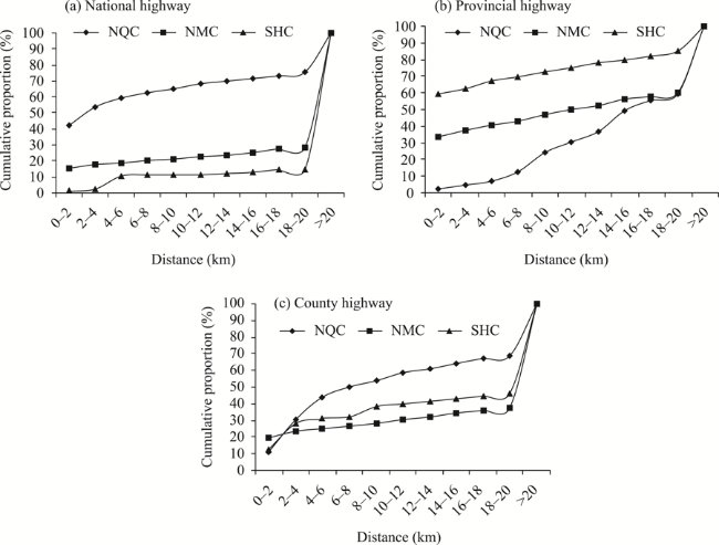
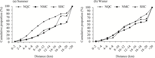
Figure 5 Traffic proximity characteristics of settlement layout

3.3.2 Location conditions

Administrative centers established with government administration as the main objective usually have strong economic and social public service functions due to their advantageous location, which can provide various basic public services including administration, trade and commerce services, culture and education, medical and health care and social security to the surrounding residents. There are significant differences in the range of various types of functions undertaken by different levels of administrative centers and in the level of service for equivalent functions. In particular, in remote and backward areas like the CTP, the variability of functional conditions that can be provided by differentiated levels of administrative centers becomes increasingly obvious (Jia et al., 2020). This paper selects county towns, township centers, and administrative villages to explore the locational selection characteristics of settlement layout in the three counties, respectively.
The tendency of administrative centers to influence the settlement layout in the study area is significant, and the attraction of high-grade administrative centers of counties with higher level of economic development to the settlements layout becomes stronger, while the tendency of low-grade administrative centers to influence the layout of settlements in counties with poor overall development conditions is more significant (Figure 6). The settlement layout of NQC shows the strongest county town tendency, with 53.31% of the county’s settlement area distributed within 30 km of the county town. However, the settlement area share of NMC and SHC is only 18.77% and 14.49% under the same conditions. NQC is the social, economic, political and cultural center of Nagqu City. It has the highest administrative rank and the most comprehensive socio-economic service functions within the prefecture-level city. In 2020, the urbanization rate of NQC has reached 25.80%, far exceeding the 5.75% and 10.35% of NMC and SHC in the same period. The relatively high degree of part-time employment, the non-agriculturalization of herders, and the diversity of livelihoods have led to a gradual shift in the siting of some herders’ settlements away from absolute dependence on pastoralism and natural pastures, and the increasing polarizing effect of the county town on population and socio-economic factors. The settlement layout of SHC has a strong administrative village tendency, and the proportion of settlements area within 2 km of administrative villages is 70.03%, while the proportion of settlements area in NQC and NMC is 28.01% and 37.57% under the same conditions, and no other settlements occurs within 30km of the county town, indicating that the settlement layout of SHC is scattered and the overall tendency of high-grade centrality is weak. The distribution of settlements in SHC is fragmented, and the tendency toward high-grade central places is weak. The population of SHC is extremely sparse, and economic development is lagging behind, except for the non-agricultural population supported by government departments, nearly 90% of the county’s population is rural population, mostly engaged in activities related to pastoral production, the site of the settlements relies heavily on natural pasture, with significant resource dependence. In addition, the economic and social service functions of the county town and township centers are weak, and the central place of the settlement layout is not strong. As the basic level of Chinese administration, administrative villages play an important role in maintaining pastoral management and social stability on the CTP. Due to their large number and wide distribution, they have become an important link whereby herders can obtain information and public product supply. They have become the center of village-level administrative divisions. Compared with SHC and NQC, the county town of NMC’s settlement layout tends to be less strong, and the proximity of township centers and administrative villages is a distinct feature.
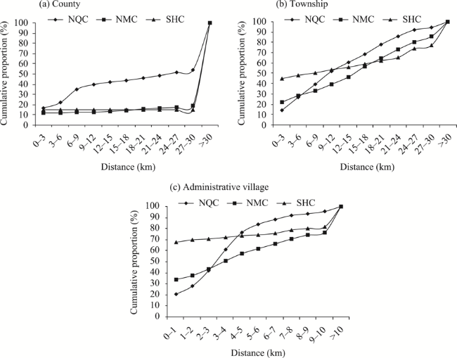
Figure 6 Location selection characteristics of settlement layout

3.3.3 Traditional production conditions

Historically, herders in northern Tibet lived by water and grass and grazed by greenery. According to seasonal changes in water and grass conditions, there are traditional grazing sites suitable for grazing in different months, and herders usually graze in winter pastures from December to May and in summer pastures from June to November (Hua et al., 2013). This paper analyzes the spatial location of settlement layout in relation to summer and winter grazing sites to explore the relationship between the current characteristics of settlement layout and traditional production conditions on the CTP.
The proximity of winter and summer grazing sites to the settlement layout of the three counties in the study area differed significantly. The proximity of summer grazing sites was significantly stronger than that of winter grazing sites in the settlements layout of NQC. The proximity of summer and winter grazing sites in the settlements layout of NMC and SHC were more similar (Figure 7). The proximity of summer grazing sites is most prominent in the settlement layout of NQC, and the proportion of settlement area within 10 km of its summer grazing sites reaches 45.01%, while the proportion of settlement area within the same range is only 18.15% and 18.45% in NMC and SHC. Because the summer grazing sites in NQC are mainly located in the southeastern part of the county, these areas are primarily mountainous and gully terrain. To meet the demand for high quality water and grass conditions for pastoral production, the sites selected for herders’ settlements follow the topography and river trend and present a relatively clustered strip. Therefore, the proportion of the area of settlements in a specific range near the summer grazing sites is relatively large. The winter grazing sites are mainly distributed in the southwestern part of the county, where the topography is cut, the density of settlements is low, and the area of settlements within a specific range from the winter grazing sites is small. The proximity characteristics of winter and summer grazing sites in the settlement layout of NMC and SHC are relatively similar, and the proportion of settlement area shows a relatively balanced gradient change with increasing distance. The reason behind this phenomenon is that the summer and winter grazing sites differ only in terms of topographic location on a small local scale. On a large scale, they are spatially cross-balanced and do not differ significantly in terms of proximity to the settlement layout. The spatial proximity of winter and summer grazing sites did not differ significantly from the settlement layout of the entire study area. The local differences were determined by the topographic conditions in which the grazing sites were located.
Figure 7 Proximity characteristics of traditional production conditions for settlement layout

3.3.4 Religious culture

Settlements are usually a unified composition of physical and spiritual forms, and different regions have unique regional genes (Liu et al., 2019). The most significant cultural genes of the Tibetan settlement layout on the QTP are Tibetan characteristics and universal religious beliefs. The religious beliefs of Tibetan Buddhism make religious temples not only a spiritual symbol of Tibetan settlements, but also an important place to provide social services for Tibetan people. To a certain extent, they assume public service functions such as culture, education, and medical care (Wang and Li, 2015). This paper extracts the spatial point locations of religious temples in the study area to investigate the influence of religious culture on the layout of settlements on the CTP. Temples in remote areas of Tibetan regions usually possess small-scale influence, this paper takes the influence of each temple on the settlements layout within its township as the research content of temple influence on settlement layout.
A total of 15 temple sites were extracted from the study area, five sites in five townships in NQC, eight sites in five townships in NMC and two sites in two townships in SHC. In general, the settlement layout of the study area has a certain degree of temple proximity (Figure 8). The percentage of settlements within 8 km of the temples is above 30%, and the local area near the temples shows settlement agglomeration. A monastic agglomeration near Tangra Yutso in NMC has a strong attraction for the population and an effect on the settlement layout. The proportion of settlement areas and settlement density in this area are among the highest in the study area (Figure 9a). The Tibetan cultural view and the natural view of equality of all beings and respect for nature have formed the ecological protection culture of Tibetan people who worship sacred mountains and lakes (Zhang et al., 2020). Together with the surrounding Dalgo Snow Mountain, Tangra Yutso has been worshipped as a holy place of God by the Yongzhong Buddhists, and it has become a place where the Tibetan people’s religious and spiritual beliefs coalesce. There are six temples around the lake, and the natural and cultural landscape of the combination of sacred mountains, sacred lake and temples has formed a strong attraction for the Tibetan people to choose the location of their settlements, and a cluster settlements pattern with sacred natural landscape and religious temples as the core of the settlements has emerged in this area. A study of the spatial layout characteristics of other temples was also conducted and found that the majority of temples are located in county towns or township government locations (Figures 9b-9e), areas with relatively large population size and economic density. This indicates that the county or township government locations on the CTP are centers of administration, economic development and social security, and they also play a comprehensive spiritual centripetal role. The layout of the temples gives an indispensable spiritual focus to the territorial space based on administrative settings (Wang and Li, 2015). This exerts a powerful potential and cohesive effect on the surrounding residents and influences the spiritual form of the central settlements.
Figure 8 Temple proximity characteristics of the settlement layout
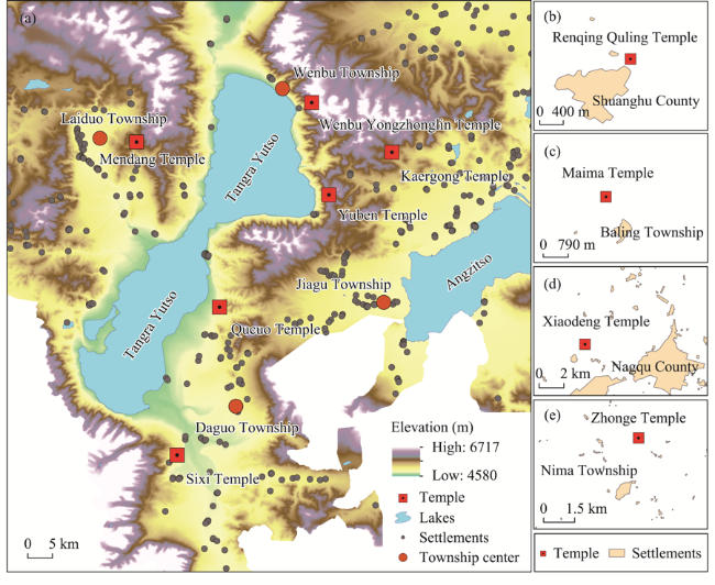
Figure 9 The symbiotic pattern of settlements and temples in the vicinity of Tangra Yutso and the proximity of the township centers where the temples are located

4 Discussion

4.1 Influence mechanism of socio-economic factors on the layout of settlements on the CTP

The settlement layout of the CTP responds significantly to socio-economic factors such as transportation, location, traditional production conditions and religion and culture. The interaction between different factors indicates a reinforcing or substitution effect on the settlement layout (Figure 10).
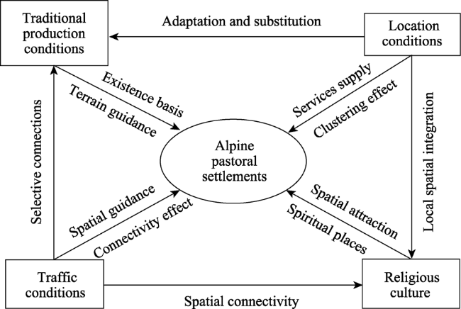
Figure 10 Socio-economic factors’ driving mechanism of settlement layout on the Changtang Plateau
(1) There is a high degree of spatial coupling between settlements and the layout of traffic routes on the CTP. The traffic directionality of the settlement layout is evident. The distance from the traffic routes determines the degree of convenience of information exchange and material exchange between herders and the outside world. Due to the harsh natural geographical environment, the Changtang Plateau has long been in a closed development state, and the road system, as the main way to connect with the outside world, has become an important medium to promote its open development and modernization. Through information exchange and material exchange with the outside world, the degree of open-mindedness and flexibility in doing things among herders in remote pastoral areas has increased significantly, and the pastoral commodity economy such as livestock products processing, commercialization, and tourism resources development has gradually flourished with the access to roads, and the Tibetan herders’ demand for convenient and comfortable high-quality life has been rising. The road system has become an important social space on the Changtang Plateau, providing an important field for the exchange and interaction of population, economy, culture and social life along the route, and becoming a place where herders tend to settle down and live. However, the construction and use of roads under the will power of the state varies in rank and quality of connectivity depending on administrative hierarchy, cost considerations, regional characteristics, and the development discourse of grassroots governments. The commonality of the settlement layout of the three counties shows that the spatial guidance effect of the traffic system on the settlements layout is significant. However, the differences in the road systems of the three counties lead to regional differences in the traffic directionality of their settlement layouts. The road system in the core area of NQC is dominated by national highway, and the settlement layout shows the strongest national highway orientation. The road system of SHC in the periphery area is dominated by provincial highway, and the proximity of provincial highway in the settlement layout is most significant. The road system of NMC in the sub-periphery area shows a relatively balanced situation of national highway, provincial highway and county highway, and the distribution of settlement shows multiple proximity.
(2) The advantageous locational orientation of the CTP settlement layout is remarkable. The administrative center with advantageous location assumes the function of public service supply and has a clustering effect on the settlement layout (Jia et al., 2020). This rule is verified on the CTP. However, there are regional differences in the tendency of the administrative center of the settlement layout arising from the differences in the development status of each county. The core area, NQC, has a high administrative level, the most comprehensive set of economic and public service functions, a relatively high county-wide overall economic level and a high degree of non-agriculturalization of the population, making it the center of access to high-grade economic and social and cultural services for the herders of the city and the entire northern Tibetan Plateau. The county town exerts a strong agglomeration effect on the settlement layout on a large scale. NMC, in the sub-periphery area, has a wide geographical area, poor natural conditions, a small county town, and limited economic functions. It has not formed an attraction for large-size settlement layout. Its population is mainly distributed in the southern part of the county, where the township density is high, all necessary public services can be provided for the surrounding herders, and the settlement layout shows a degree of township centers tendency. The natural environment of SHC in the periphery area is the most severe. The population is extremely sparse, and the county town and township centers have a single function. They are few in number and widely distributed. The county town and township centers did not have exerted a significant agglomeration effect on the settlement layout because most of the population in the county is engaged in pastoral production activities and is highly dependent on natural pastures. As the most basic administrative unit, the administrative village plays a vital role as a link in the provision of public services and grassroots governance in an extremely sparsely populated area like SHC. The construction and equipping of public facilities in the administrative villages has a cohesive effect within the villages, and the settlements show the most prominent administrative village tendency.
(3) Traditional production conditions are the basis for the evolution of the settlement system. The spatial adaptability of alpine pastoral settlement layout to winter and summer grazing sites shows a small range of differences in characteristics. The distribution differences are mainly determined by topographic conditions. Behind the selection of winter and summer pastures for traditional grazing production on the Changtang Plateau lies the characteristics of the influence of grassland type on grazing activities. Kobresia pygmaea and Kobresia littledalei are two important grass species on the Changtang Plateau. Kobresia pygmaea grows on flat land and mountain slope, with short growth cycle and excellent quality, and is the main forage grass in summer and autumn. Kobresia littledalei has coarse and hard texture, poor palatability, but high grass production, and it is not easy to cover after snow in winter, so it is the main food grass for livestock in winter. According to the growth characteristics and distribution of grass species, herders’ summer pastures are usually in the mountains, and winter pastures are usually located in depressions and other areas that are sheltered from wind and snow. On a larger spatial scale, winter and summer grazing sites were intertwined and distributed, and both did not show significant exclusive spatial clustering. Our study of the settlement layout on the CTP found that nearly one-third of the settlement area in the study area was distributed within 10 km of traditional grazing sites, indicating that the current settlements pattern retains a degree of locational choice for traditional grazing activities. The spatial proximity of winter and summer grazing sites in the study area did not differ very significantly. The appearance of local differences was determined by the topographic conditions in which the winter and summer grazing sites were located. The changes in production and living conditions such as settled grazing, artificial grass cultivation, part-time employment and non-agricultural employment have changed the absolute dependence of Tibetan herders’ settlement sites on traditional grazing production conditions. The settlement layout of the CTP has changed from resource dependence to dependence on multiple elements such as resources and facilities.
(4) The religious-cultural elements carried by sacred mountains, lakes, and temples have a strong attraction to the layout of settlements, leading to the clustering of settlements in local areas to form a cluster pattern. Religious activities are one of the most important social practices of Tibetan people, penetrating into all areas of their production and life, profoundly influencing their thoughts, cultural psychology and economic life, and the unique ecological ethical concept that accompanies it is also one of the key influencing factors that distinguish the layout of human settlements on the Changtang Plateau from that of other ethnic groups and non-ethnic areas. The Tibetan people’s worship of sacred mountains, sacred lakes and other natural landscapes and the religious beliefs of Tibetan Buddhism are a very complex and important set of ideologies that govern the siting of settlements and settlement patterns. Religious temples as human constructs, provide important places for social activities and spiritual cohesion for herders, and based on meeting the needs of daily production activities, settlements tend to be located close to temples. Even if some villages lack temples, they still have places that carry their spiritual beliefs - marnyi stone or white pagodas and other religious symbols, which constitute the spiritual space of the village. Religious symbols in Tibetan areas, whether they are sacred lakes, sacred mountains or religious temples, serve as centers of religious belief and bear the unique public service needs of Tibetan people. When the needs of production and spirituality can be satisfied in one place simultaneously, the phenomenon of cluster distribution with multiple clusters of natural landscape-temples- settlements will emerge (Figure 9).
(5) The interaction of transportation and location, as artificially created socio-economic elements, with religious and cultural elements strengthens the attraction effect of each element on the settlement layout while also having a selection and substitution effect on traditional production conditions. With the development of socio-economic system and the increasing ability and demand of human beings to transform nature, various infrastructures for optimizing the habitat environment are being built, the participation of human activities in creating the ecosystem of their settlement environment is growing, and people’s requirements for the settlement environment are gradually changing from natural ecology to comprehensive ecology (Zhou et al., 2013). In the course of opening up and developing of the Changtang Plateau, various construction activities are also continuously optimizing and improving the human living environment here. On the basis of meeting the basic production and living needs of alpine pastoral areas, the site selection of settlements has gradually shifted from the initial demand for survival and security to the demand for convenience, economy and comfort, and the site selection of settlements has evolved in the direction of meeting integrated functions. Our study of the settlement layout on the CTP found that religious temples are usually located in county towns or township centers. County towns and township centers are usually connected to transportation hubs or trunk roads. The local spatial coupling of the three types of elements further enhances the ability of the area to provide comprehensive service functions and further strengthens the attractiveness of the layout of settlement. The grazing point is a traditional production condition in the context of absolute dependence on grassland resources in the nomadic way of life of herders. The changed socio-economic system on the CTP has transformed the site selection of herders’ settlements from resource dependence to multifactor dependence on resources and facilities. The attraction of some grazing sites to settlement layout has been gradually replaced by the advantageous transportation and location conditions in other areas.

4.2 The impact of national nature reserve construction on the layout of settlements in northern Tibet

Since the migration of northern Tibetan herders northward into the Changtang Plateau uninhabited area in the 1970s (Li, 1997; Tang, 2012), the scale of animal husbandry in northern Tibet has been expanding, and the space for human activities and wildlife survival has been highly overlapping. In order to harmonize the relationship between human and land in this area and develop the cause of wildlife conservation, Changtang Nature Reserve was approved by Tibet Autonomous Region in 1993 and upgraded to a national nature reserve in 2000. As the livelihoods of herders in northern Tibet are highly dependent on grass and livestock resources, the scale of grass and livestock resources to be utilized further expands as the level of herders’ living needs continues to grow. Meanwhile, due to the limited management efficiency of the plateau reserve and the vast uninhabited area in the northern part of the Changtang Plateau, the boundaries of human activities within the Changtang Plateau have been expanding northward in order to further obtain productive materials. In addition, the construction of the reserve system has to some extent contributed to the growth of herbivore populations (Fan et al., 2022), further exacerbating the grass-livestock conflict and becoming another incentive to drive human activities northward. According to the estimation, the boundary of human grazing and settlement distribution has shifted 118.7 km northward to the Changtang Nature Reserve during 1980-2015 (Fan et al., 2022; Zhang et al., 2022), which has penetrated into the buffer zone of the reserve. In 2012, the State Council of the People’s Republic of China approved the establishment of Shuanghu County, the highest county-level administrative unit in the world, in the hinterland of the Changtang Plateau. Thus, on the whole, the construction of the Changtang National Nature Reserve has played an important role in protecting wildlife, but has had a limited role in restraining the northward expansion of human settlement boundaries driven by livelihoods.

4.3 Functional characteristics of the CTP towns

Towns are the central place for public service provision and have an important impact on economic and social development. The CTP is vast and sparsely populated, with less than one person per square kilometer, a gap of more than a hundred times the population density of the plains (Li et al., 2020). In contrast to the settlement size of the plain farming areas, which is measured in km2 (Hai et al., 2013), the average patch size of the settlements on the CTP is only 0.5 ha. It is much smaller than the density feature of several settlement patches distributed within each square kilometer in low-altitude hilly areas (Guo et al., 2013; Zhang et al., 2022), and there is only one settlement on the CTP in an average area of 35 km2. Due to the above-mentioned special characteristics of population and settlement distribution and the backward economic development level on the CTP, most of the towns were established to maintain regional stability and perform administrative management and other basic administrative service functions, with insufficient endogenous power of development and weak economic functions (Fan and Wang, 2005). Their attraction and radiation effect on population and settlement layout is significantly weaker than that of rapidly urbanizing areas (Song and Li, 2020). However, due to differences in the natural environmental conditions and the transportation locations of different counties, the functional structure is in a developmental state of dynamic change. This paper found that the effect of towns on the settlement layout of the CTP means that the economic functions of each county town gradually diminish from the core county NQC to the peripheral county SHC, and the county town functions show a differentiated combination structure. The administrative functions of NQC, the center of a prefecture-level city, are relatively complete and can provide the most comprehensive and highest standard of public service supply in the region. The development conditions are relatively superior, and the economic functions are strong, providing non-agricultural employment opportunities for the surrounding herders and having a significant agglomeration effect on the layout of county settlements (Zhang et al., 2019). In contrast, NMC and SHC have extremely harsh natural conditions and small county towns that only offer basic administration and public service functions. Township enterprises in the two counties are almost blank and have weak economic functions, as a result of which, they have not exerted a clustering effect on the spatial layout of settlements. For example, the area of SHC is only 0.54 km2, and there are no other settlement patches within 30 km of the county town.
Based on the above analysis, this paper compares the characteristics of alpine pastoral towns on the CTP and plain agricultural towns (Table 4). The alpine pastoral areas are vast and sparsely populated. The towns are small in size and single in function, with weak agglomeration effects on population and economic factors and weak development momentum. Compared with the alpine pastoral areas, the towns in the plain agricultural areas have large populations, large areas, limited land resources, deep integration of integrated and diversified administrative and economic functions, and strong town development dynamics. The towns can provide work opportunities and diversified and high-quality public service supplies for the nearby residents, with significant agglomeration effects on population and economic factors (Fan and Wang, 2005; Zhou et al., 2013; Ma et al., 2019; Li et al., 2020). In terms of development stages, the plain agricultural towns are at the mature stage of town development, while the alpine pastoral towns are at the embryonic or early stage of town development. The functional characteristics of some towns on the CTP are characterized by strong administrative functions and weak economic functions, and the administrative and economic functions are not developed simultaneously. Influenced by the natural environmental conditions and development foundation, the development stage of towns in the alpine pastoral areas of the CTP lags significantly behind that of the plain agricultural areas.
Table 4 Comparison of the characteristics of alpine pastoral towns on the Changtang Plateau and plain agricultural towns
Characteristics Alpine pastoral towns Plain agricultural towns
Population Sparsely populated Intensive
Area Minimal Large
Land resources Wide geographical area Limited land area and concentrated layout
Human-land relationship Attracting population transfer through construction improvement and slow development Increasing population drives land expansion and frequent dynamic changes
Agglomeration effect on population and economic factors Weak Strong
Functional structure Mainly administrative and public service functions, single function Administrative functions and economic functions are integrated and developed, with diverse functions and stronger economic functions
Development momentum Government macro-control and public policy driven, with a few central towns having economic drive Factor-driven economy with strong endogenous dynamics
Support systems Transfer payments, counterpart support and financial subsidies Economic dividend and social efficiency

4.4 Policy implications

Public service supply should be the basic function of Tibetan towns and central settlements. This functionality is also the basic guarantee of a better life for Tibetan people. However, due to the realities of vast land, sparse population, and harsh natural conditions, the administrative centers at all levels on the CTP suffer from poor public service supply capacity and low quality. In terms of medical conditions, the three counties in the study area have only one township health center in each township, apart from the county town. Each township health center has, on average, only two practicing physicians. Our field research showed that in 2020, 14,500 people in SHC had only 31 practicing physicians, one-third of whom were physician assistants, and there was a serious lack of medical resources. From the road system construction, as of 2020, in addition to 12 townships in NQC to achieve all smooth, NMC and SHC still have 3 and 4 townships only to achieve road access and not smooth. The smooth rate of administrative villages in the three counties is 77.30%, 40.26% and 25.81% respectively, the smooth rate of road system is not high and the construction status is still backward.
From the perspective of optimizing the layout of the settlement system and improving the supply capacity of public services and the quality of production and life of the Tibetan people, the following aspects should be emphasized in optimizing the settlement system of the CTP. (1) Implementation of local area settlement withdrawal and relocation. The settlements in the northern part of SHC and NMC near the uninhabited area are extremely small in size and scattered. The natural environment is extremely harsh. The suitability for human survival is poor, and human activities are likely to cause ecological security risks. Therefore, the government should formulate a policy of gradual withdrawal of settlements and transfer them to areas with stronger pastoral carrying capacity in the southern part of the county or to Nagqu and Lhasa cities. The government should deliver survival skills training to the transferred herders to improve their non-agricultural employment capacity. (2) Execution of strategy of moderate concentration of settlements and provision of a guarantee to supply basic public services. In the areas with stronger resources and environmental carrying capacity in the southern parts of NMC and NQC, the government should promote and introduce the planting of high-quality grass seed to improve quality and efficiency. The government should promote the scattered settlements to the central settlements moderate concentration, optimizing the coupling development of pastoral industrialization and settlement space, reducing the cost of public facilities allocation, and enhancing the public service guarantee capacity. (3) Create a regional settlements hierarchy system and build an interconnection network based on nodes. Taking the townships and administrative villages along with the county, provincial, and national highways as the core nodes, build a top-down multi-level settlements hierarchy consisting of NQC county town-NMC county town, and the key townships along National Highway 317 and the central villages along provincial highways. To further improve the level of road smooth between nodes at all levels, the road network as a backbone to form a “point -axis” system of spatial connectivity, element transfer and functional support, providing a variety of supply space for different levels of public services.

5 Conclusions

Based on the core-periphery theory of geography, this paper selected three counties with gradient transition characteristics in physical geography and socio-economic conditions as case areas. It used the data set of settlement patches identified by visual interpretation and combined them with field survey data to conduct a study on the evolutionary history of human settlements and the settlement layout characteristics and their socio-economic roots in the marginal zone of the CTP uninhabited area. The study found that:
(1) Since the democratic reform in Tibet, the production mode of the CTP herders has undergone a transformation from four-season nomadic herding to cold-season sedentary feeding, warm-season rotational herding, and then sedentary grazing with additional forage supplementation. The form of herders’ dwelling has changed from tents to fixed houses to courtyards with various functions. The form of settlements has also changed from settlements under the semi-settlement mode to villages. In the process of promoting the construction of grassroots administration, the boundaries of villages have been gradually clarified, the range of pasture grazing is gradually defined, and the settlement system of alpine pastoral areas had gradually developed and taken shape.
(2) The layout of human settlements on the CTP shows a certain degree of agglomeration in local areas on a large scale. The spatial agglomeration of settlements gradually decreases as the observation scale transitions from the county to the township and then to the administrative village level. This indicates that the exploration of multi-scale space is beneficial in fully revealing the agglomeration and sparseness of local settlements. The settlement size structure conforms to the rank-size rule of typical rural settlements, and, this indicates that the settlement system of the CTP tends to mature.
(3) The settlement layout of the CTP has significant road proximity characteristics, and the settlement layout is more strongly influenced by high-grade roads in counties with high levels of economic development. The administrative center of settlement layout tends to be obvious, and the tendency of different levels of administrative centers shows regional differences due to the “core-periphery” structure of the three counties. The current settlement pattern retains a certain degree of locational choice of traditional grazing activities. The change in production conditions has affected the absolute dependence of Tibetan herders’ settlement site selection on traditional grazing production conditions, and the settlement layout has shifted from resource dependence to the dependence of multiple elements such as resources and facilities. The religious-cultural elements embodied by sacred mountains, lakes and temples have a strong impact on the layout of settlements, leading to the clustering of settlements in local areas to form a cluster pattern. The interaction of transportation and location, as artificially created socio-economic elements, with religious and cultural elements strengthens the attraction effect of each element on the settlement layout while also having a selection and substitution effect on traditional production conditions.
Because large-scale socioeconomic data at the settlement patch scale were not obtained, the study of factors influencing settlement layout was not explored by means of econometric models and other means, which is a limitation of this paper. The systematic research and interviews with herding households at microscopic scale and the selection of typical villages for in-depth microscopic case studies are not only helpful to further reveal the deep mechanism of settlement pattern formation under various settlement patterns in the northern Tibetan pastoral areas, but also have important practical guidance significance for optimizing the human living environment in the northern Tibetan Plateau in the context of rural revitalization in the new era, and these aspects are what the subsequent research of this paper needs to focus on.
[1]
Allan J R, Venter O, Watson J E M, 2017. Temporally inter-comparable maps of terrestrial wilderness and the last of the wild. Scientific Data, 4(1): 1-8.

[2]
Fan J, Liang B, Liu H et al., 2022. Impact on local sustainability of the northward expansion of human activities into protected areas in northern Tibet. Land Degradation & Development, 33(15): 2945-2959.

DOI

[3]
Fan J, Wang H, 2005. Spatial analysis of population development and discussion of sustainable urbanization in Tibet. Scientia Geographica Sinica, 25(4): 385-392. (in Chinese)

DOI

[4]
Farrington J D, Tsering D, 2019. Human-snow leopard conflict in the Chang Tang region of Tibet, China. Biological Conservation, 237: 504-513.

DOI

[5]
Fernanda T A, Homeier J, Draper Munt D, 2017. Spatio-temporal analysis of the human footprint in South Ecuador: Influence of human pressure on ecosystems and effectiveness of protected areas. Applied Geography, 78: 22-32.

DOI

[6]
Guo X D, Ma L B, Zhang Q Y, 2013. The spatial distribution characteristics and the basic types of rural settlement in loess hilly area: Taking Qin’an county of Gansu province as a case. Scientia Geographica Sinica, 33(1): 45-51. (in Chinese)

[7]
Hai B B, Li X J, Xu J W, 2013. Spatio-temporal evolution of rural settlements in Gongyi. Geographical Research, 32(12): 2257-2269. (in Chinese)

DOI

[8]
Hua X B, Yan J Z, Liu X, 2013. Settled herdsmen’s adaptation strategies to pasture degradation: Case study of Naqu County in Tibet Plateau. Journal of Mountain Science, 31(2): 140-149. (in Chinese)

[9]
Jia W, Gao L J, Li Q, 2020. Spatial variation of public goods supply between urban and rural areas in Tibetan areas of China: An analysis of spatially divergent distribution and its causes. Tibetan Plateau Forum, 8(2): 49-57. (in Chinese)

[10]
Lang W W, Zhao S B, 2010. The change from settlement to villages of nomads in northern Tibet: Study of two villages of Dagedo and Zhongrege of Naqu. Tibetan Studies, (6): 37-47. (in Chinese)

[11]
Lang W W, Zhao S B, 2013. The Changes of traditional animal husbandry livelihood way of the north Tibet herdsmen: Investigation of the society of villages in Nakchu Prefecture. Tibetan Studies, (5): 41-51. (in Chinese)

[12]
Lang W W, Zhao S B, Zhang P, 2013. Social Change of Pastoralism in Northern Tibet:An Anthropological Examination of Pastoralists’ Enjoyment of Rights in Dagedo and Zhongrege Villages. Beijing: The Ethnic Publishing House.

[13]
Li G, Jiang G, Jiang C et al., 2018. Differentiation of spatial morphology of rural settlements from an ethnic cultural perspective on the Northeast Tibetan Plateau, China. Habitat International, 79: 1-9.

DOI

[14]
Li L, Li X, Hai B et al., 2020. Evolution of rural settlement in an inland nonmetropolitan region of China at a time of rapid urbanisation: The case of Gongyi. Journal of Rural Studies, 79: 45-56.

DOI

[15]
Li M, 1997. Changtang Uninhabited Area Exploration. Zhengzhou: Henan Science and Technology Press. (in Chinese)

[16]
Li M, Vliet J, Ke X et al., 2019. Mapping settlement systems in China and their change trajectories between 1990 and 2010. Habitat International, 94: 102069.

DOI

[17]
Liu W, Henneberry S R, Ni J et al., 2019. Socio-cultural roots of rural settlement dispersion in Sichuan Basin: The perspective of Chinese lineage. Land Use Policy, 88: 104162.

DOI

[18]
Luo X, Yang J, Sun W et al., 2021. Suitability of human settlements in mountainous areas from the perspective of ventilation: A case study of the main urban area of Chongqing. Journal of Cleaner Production, 310: 127467.

DOI

[19]
Ma X Y, Rong L H, Xing J X, 2019. The evolution of man-land relation and sustainable development research in prairie cities: Taking Xinbaolage Town in Xilingol League, Inner Mongolia as an example. Development of Small Cities & Towns, 37(4): 11-19. (in Chinese)

[20]
Song W, Li H H, 2020. Spatial pattern evolution of rural settlements from 1961 to 2030 in Tongzhou District, China. Land Use Policy, 99: 105044.

DOI

[21]
Sonis M, Grossman D, 1984. Rank-size rule for rural settlements. Socio-Economic Planning Sciences, 18(6): 373-380.

DOI

[22]
Sun Y X, Liu S L, Shi F N et al., 2020. Spatio-temporal variations and coupling of human activity intensity and ecosystem services based on the four-quadrant model on the Qinghai-Tibet Plateau. Science of the Total Environment, 743: 140721.

DOI

[23]
Tang C, He Y, Zhou G et al., 2018. Optimizing the spatial organization of rural settlements based on life quality. Journal of Geographical Sciences, 28(5): 685-704.

DOI

[24]
Tang Z, 2012. Traveling through the Northern Tibet Uninhabited Areas:A Chronicle of the Changes in Changtang. Beijing: China Intercontinental Press. (in Chinese)

[25]
Tian R, Ma H L, 2020. Roads and settlement change: An anthropological study based on the area of Ulan County along the Qinghai-Tibet railway and highway. Tibetan Plateau Forum, 8(2): 37-43. (in Chinese)

[26]
Wang L C, Li W, 2015. “Symbiotic” effect of Tibetan tribe-Tibetan Buddhist temples-rural settlement: A case study in Luqu, Gannan Tibetan Autonomous Prefecture. Economic Geography, 35(4): 135-141. (in Chinese)

[27]
Wu J G, Zhang X L, Ji Y Z et al., 2013. Transports influence on rural settlement landscape pattern at county scale: A case study of Yongqiao of Suzhou. Human Geography, 28(1): 110-115. (in Chinese)

[28]
Xu Z R, Cheng S K, Gao L W, 2017. Impacts of herders sedentarization on regional spatial heterogeneity and grass land ecosystem change in pastoral area. Journal of Arid Land Resources and Environment, 31(6): 8-13. (in Chinese)

[29]
Xu Z R, Wei Z, Jin M M, 2020. Causes of domestic livestock-wild herbivore conflicts in the alpine ecosystem of the Chang Tang Plateau. Environmental Development, 34: 100495.

DOI

[30]
Xu Z R, Zhen X, Jin M M, 2018. Harmonizing conflicts of land multifunction in natural reserves: Qiangtang National Natural Reserve as an example. Science & Technology Review, 36(7): 8-13. (in Chinese)

[31]
Xue Z, Lyu X, Chen Z et al., 2018. Spatial and temporal changes of wetlands on the Qinghai-Tibetan Plateau from the 1970s to 2010s. Chinese Geographical Science, 28(6): 935-945.

DOI

[32]
Yang X T, Qiu X P, Fang Y P et al., 2019. Spatial variation of the relationship between transport accessibility and the level of economic development in Qinghai-Tibet Plateau, China. Journal of Mountain Science, 16(8): 1883-1900.

DOI

[33]
Yi J, Du Y, Liang F et al., 2020. Mapping human’s digital footprints on the Tibetan Plateau from multi-source geospatial big data. Science of the Total Environment, 711: 134540.

DOI

[34]
Yin G, Niu F, Lin Z et al., 2017. Effects of local factors and climate on permafrost conditions and distribution in Beiluhe basin, Qinghai-Tibet Plateau, China. Science of the Total Environment, 581/582: 472-485.

DOI

[35]
Zhang H P, Fan J, He R W et al., 2019. Spatio-temporal evolution of settlements and its driving mechanisms in Tibetan Plateau pastoral area: Taking Nagqu County in the northern Tibet as an example. Scientia Geographica Sinica, 39(10): 1642-1653. (in Chinese)

DOI

[36]
Zhang H P, He R W, Liu Y W et al., 2020. Land suitability evaluation and reconstruction of settlements in the pastoral area of Tibetan Plateau: A case study of Nagqu county in northern Tibet. Journal of Natural Resources, 35(3): 698-712. (in Chinese)

DOI

[37]
Zhang H P, Liu H C, Sun Y et al., 2022. Spatial differentiation characteristics of human settlements and their responses to natural and socioeconomic conditions in the marginal zone of an uninhabited area, Changtang Plateau, China. Chinese Geographical Science, 32(3): 506-520.

DOI

[38]
Zhao X Y, Li W, 2019. Review of Gannan research in Chinese geography. Geographical Research, 38(4): 743-759. (in Chinese)

DOI

[39]
Zhou G, He Y, Tang C et al., 2013. Dynamic mechanism and present situation of rural settlement evolution in China. Journal of Geographical Sciences, 23(3): 513-524.

DOI

Outlines

/