Research Articles

Relationship between potential waterway depth improvement and evolution of the Jingjiang Reach of the Yangtze River in China

  • YANG Yunping , 1 ,
  • LI Ming 2 ,
  • LIU Wanli 1 ,
  • CHAI Yuanfang 3 ,
  • ZHANG Jie 1 ,
  • YU Wenjun 2
Expand
  • 1. Tianjin Research Institute for Water Transport Engineering, Ministry of Transport, Tianjin 300456, China
  • 2. Changjiang Waterway Institute of Planning and Design, Wuhan 430040, China
  • 3. Institute of International Rivers and Eco-security, Yunnan University, Kunming 650000, China
*Chai Yuanfang (1993-), Senior Engineer, E-mail:

Yang Yunping (1985-), PhD and Associate Professor, E-mail:

Received date: 2021-11-17

  Accepted date: 2022-03-15

  Online published: 2023-03-21

Supported by

National Natural Science Foundation of China(52279066)

Fundamental Research Funds for Central Welfare Research Institutes(TKS20190406)

Follow-up Scientific Research Project of the Three Gorges Project(SXHXGZ-2022-1)

Abstract

Given the importance of waterway depths in river development, the effects of the evolution of bars and troughs on waterway expansion play an important role in river management and water depth conservation. This study aims to expand the waterway dimensions of the Jingjiang Reach of the Yangtze River. To achieve this objective, determining the relationship between river evolution processes and the potential for waterway depth improvement and navigation hindrances is vital. Therefore, the sedimentation, hydrological, and terrain data of the Jingjiang Reach from 1955 to 2020 are analysed to elucidate the above-mentioned relationship. Since the commissioning of the Three Gorges Dam, the scouring of the low-flow channel has accounted for 90%-95% of all scouring in the Jingjiang Reach. Furthermore, the central bars and beaches have shrunk by 9.4% and 24.9%, respectively, and 18.3% overall. Considering the bed scouring and waterway regulation projects in the Jingjiang Reach, we investigated the continuity of a 4.5 m × 200 m × 1050 m (depth × width × bend radius) waterway along the Jingjiang Reach, and find that navigation-hindering channels account for over 5.3% of the waterway length. Furthermore, part of the Jingjiang Reach is an important nature reserve and shelters numerous water-related facilities, which inhibits the implementation of waterway deepening projects. The findings of this study demonstrate that numerous challenges are associated with increasing the waterway depths of the Jingjiang Reach.

Cite this article

YANG Yunping , LI Ming , LIU Wanli , CHAI Yuanfang , ZHANG Jie , YU Wenjun . Relationship between potential waterway depth improvement and evolution of the Jingjiang Reach of the Yangtze River in China[J]. Journal of Geographical Sciences, 2023 , 33(3) : 547 -575 . DOI: 10.1007/s11442-023-2096-8

1 Introduction

Inland shipping plays an important role in global transportation and logistics systems (Rohács et al., 2007; Willems et al., 2018); thus, the development of riverine shipping is significant for watershed resource utilisation. The shipping potential of a river is limited by its carrying capacity, which mainly depends on hydrogeomorphic factors, such as river depth, width, flow rate, and duration of icing events (Hijdra et al., 2014). Furthermore, considering the recent implementation of environmental conservation strategies in waterways, the effects of waterway engineering on river environments cannot be ignored (Weber et al., 2017). The middle and lower reaches of the Yangtze River are known as the ‘Golden Waterway’ (Cao et al., 2010; Wang et al., 2020b) because they play a central role in the socioeconomic development of the Yangtze River. As of 2020, the Yangtze River trunk line contained a freight volume of 3.06 × 10⁸ t·yr-1, and accounted for 78.2% of the total inland waterway freight transport in China.
The Jingjiang Reach, located in the middle reaches of the Yangtze River, is ~60 km away from the Three Gorges Dam (TGD) and has no major tributaries or confluences (Figure 1). Therefore, its hydrologic and sedimentary conditions are directly affected by the TGD operations. Over the past 60 years, the runoff flowing through the Jingjiang Reach has not significantly changed (Chai et al., 2019, 2020; Yang et al., 2019). However, its sediment load has decreased over time, owing to the implementation of water and soil conservation measures and dam construction upstream (Yang et al., 2006; Yang et al., 2015b). Ever since the TGD began to hold back water, the sediment load has gradually decreased (Hassan et al., 2010; Dai et al., 2018; Li et al., 2018a; Gao et al., 2020; Peng et al., 2020; Tian et al., 2021), resulting in a higher scouring rate for the Upper Jingjiang Reach compared with the Jingjiang Reach (Dai and Liu, 2013; Xia et al., 2016, 2017; Lyu et al., 2018). Furthermore, the sedimentary regime of the Lower Jingjiang Reach changed from ‘groove scouring with bar deposition’ to ‘groove and bar scouring’ (Xu, 2013; Xu et al., 2011, 2013; Yang et al., 2018, 2022a). Additionally, there have been numerous instances of riverbank collapse (Xia et al., 2016; Xia et al., 2017; Zhou et al., 2017; Zong et al., 2017; Deng et al., 2018, 2019; Lyu et al., 2020), shrinking beaches and central bars (Yang et al., 2015a; Wang et al., 2018; Li et al., 2019), and unstable water diversion ratios in the Jingjiang Reach (Wang et al., 2019; Hu et al., 2020; Yang et al., 2021, 2022b). The Lower Jingjiang Reach has also exhibited a chute cut-off at its tighter bends (He et al., 2020). Owing to the above-mentioned issues, it is challenging to stabilise and improve the waterway conditions in the Jingjiang Reach. To combat the increased scouring rate in the downstream reaches of the TGD since its impoundment (Liu et al., 2017; Yang et al., 2017), the Ministries of Water Resources and Transport have implemented systematic river and waterway regulation projects, which have increased the waterway depth of the Yangtze River trunk line from 0.6 m (i.e., the value at the early stages of the TGD operation) to 4.5 m (Yang et al., 2019). However, in the Jingjiang Reach, river scour has reduced the dry-season water level per flow rate over time (Sun et al., 2011; Han et al., 2017a; Yang et al., 2017; Zhu et al., 2017a, 2017b), and studies also show that this downward trend is significant (Fang et al., 2012). Although several waterway regulation projects have been implemented at the Shashi Reach, the low beaches of this section still undergo scouring. Furthermore, the main and tributary branches of the Taipingkou and Sanbatan central bars alternate with each other (Yang et al., 2021). Moreover, floods that occurred in 2010, 2016, and 2020 in the middle and lower reaches of the Yangtze River have exacerbated the navigation hindrances at the sandy cobble (Zhicheng-Dabujie) (Li et al., 2021) and the Shashi Reach (Zhang et al., 2016; Yang et al., 2021). An evaluation of the ecological effects of a waterway regulation project at the Jingjiang Reach using the analytical hierarchy process revealed that the completion of this project would benefit the ecological health of the Yangtze River (Li et al., 2017; Li et al., 2018b). Numerous studies have examined the siltation processes, beach and channel evolution, navigation hindrances, and waterway regulation projects of the Jingjiang Reach. However, the relationships between the waterway projects and potential water depth improvement in this area have not been investigated.
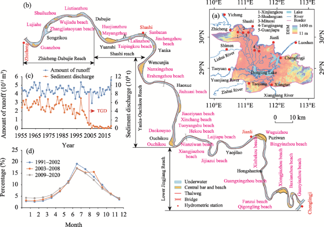
Figure 1 Location and river regime of river reach (a. Yangtze River Basin; b. Jingjiang Reach; c. Annual runoff and sediment; d. Annual process of annual runoff and sediment)
To overcome this shortcoming, we study the relationships between the potential water depth improvement and hydrogeomorphic factors of the Jingjiang Reach. We use the hydrologic and sedimentation data of 1955-2020 and the 2002-2020 riverbed measurement data of the Jingjiang Reach to analyse the scouring and deposition distributions on the riverbed, channel bars and beaches on the waterway, and water diversion ratios. Furthermore, we study the suitability of the Jingjiang Reach for water depth improvement to up to 4.5 m according to its water levels, beach and central bar morphologies, and water diversion ratios. The findings of this study elucidate the potential of the Jingjiang Reach for further waterway development.

2 Study area and data

2.1 Study area and hydrologic conditions

The Jingjiang Reach is located in the middle reaches of the Yangtze River (Figure 1a) and stretches 347.2 km from the Zhicheng hydrological station to Chenglingji. The Jingjiang Reach is divided at Ouchikou into the Upper Jingjiang and Lower Jingjiang Reaches, whose lengths are 171.7 and 175.5 km, respectively (Figure 1b). The Jingjiang Reach has a gravelly riverbed from the Zhicheng hydrological station to Dabujie and a sandy riverbed from Dabujie beyond. From 1955 to 2020, the runoff measurements by the Zhicheng hydrological station did not vary substantially, because the average annual runoff from 2003 to 2020 was only 4.6% lower than those of 1955-2002 (Figure 1c). However, the sediment transport rates measured by the Yichang hydrological station for the 2003-2020 period were 92.9% and 91.5% lower than those of the 1955-2002 and 1986-2002 periods, respectively. Compared with 1991-2002, the 2003-2008 and 2009-2020 periods exhibited lower average runoff levels in July, August, and October; similar runoff levels in June and November; and higher runoffs from December to May (Figure 1d).
The Jingjiang Reach includes 33 waterways and 33 central bars or beaches (Table 1), including 12 central bars: the Guanzhou central bar (GZCB), Lujiahe central bar (LJHCB), Shuiluzhou central bar (SLZCB), Liutiaozhou central bar (LTZCB), Huojianzhou central bar (HJZCB), Mayangzhou central bar (MYZCB), Taipingkou central bar (TPKCB), Sanbatan central bar (SBTCB), Nanxingzhou central bar (NXZCB), Daokouyao central bar (DKYCB), Daokouyao central bar (DKYCB), and Wuguizhou central bar (WGZCB). Of the 21 beaches, 15 are located on straight sections or single bends: the Jincnegzhou beach (JCZB), Jiuhuasi beach (JHSB), Jiaoziyuan beach (JZYB), Xinchang beach (XCB), Tuoyangshu beach (TYSB), Nianziwan beach (NZWB), Hekou beach (HKB), Jijiazui beach (JJZB), Laijiapu beach (LJPB), Bingyinzhou beach (BYZB), Guangxingzhou beach (GXZB), Fanzui beach (GZB), Xiongjiazhou beach (XJZB), Qigongling beach (QGLB), and Guanyinzhou beach (GYZB). Additionally, six beaches are located on braided reaches: the Zhangjiataoyuan beach (ZJTYB), Wujiadu beach (WJDB), Lalinzhou beach (LLZB), Yanglinji beach (YLJB), Xiangjiazhou beach (XJZB), and Xinhekou beach (XHKB).
Table 1 Waterway name and river regime pattern of the Jingjiang Reach
Serial number Waterway Length (km) Beach name Form Main branch in dry season Branch length Type and position of beaches
Type Position
1 Zhicheng 6.0 / Straight / / / /
2 Guanzhou 10.9 Guanzhou Branch Right Left < right Central bar Right bank
3 Lujiahe 11.1 Lujiahe Branch Right Left > right Central bar Right bank
4 Zhijiang 10.0 Shuiluzhou Branch Right Left < right Central bar Left bank bias
Zhangjiataoyuan Bending / / Beach Right bank
5 Liuxiang 5.6 Liutiaozhou Branch Right Left > right Central bar Left bank bias
6 Jiangkou 7.5 Wujiadu Straight / / Beach Right bank
7 Dabujie 11.3 Huojianzhou Branch Right Left > right Central bar Left bank bias
8 Yuanshi 17.1 Mayangzhou Branch Right Left < right Central bar Left bank bias
9 Taipingkou 17.5 Taipingkou Branch Right Left = right Central bar Midst
Sanbatan Right Left < right Central bar Midst
Lalinzhou / / Beach Right bank
10 Wakouzi 9.1 Jinchnegzhou Bending / / Beach Right bank
11 Majiazui 12.5 Nanxingzhou Branch Right Left < right Central bar Left bank bias
12 Douhudi 9.9 / Bending / / / /
13 Majiazhai 9.8 Ershengzhou Straight / / Beach Left bank
14 Haoxue 6.7 / Bending / / / /
Serial number Waterway Length (km) Beach name Form Main branch in dry season Branch length Type and position of beaches
Type Position
15 Zhougongdi 10.1 Jiuhuasi Bending / / Beach Left bank
Jiaoziyuan / / Beach Left bank
16 Tianxingzhou 16.9 Xinchnag Bending / / Beach Left bank
17 Daokouyao 7 Tuoyangshu Branch / / Beach Left bank
Daokouyao and Ouchikou Left branch Left < right Central bar Right bank
18 Shishou 10.0 Xiajiangzhou Bending / / Beach Left bank
19 Nianziwan 17.0 Nianziwan Bending / / Beach Right bank
20 Hekou 5.0 Hekou Bending / / Beach Left bank
21 Tiaoguan 16.0 Jijiazui Bending / / Beach Left bank
22 Laijiapu 12.0 Liajiapu Bending / / Beach Right bank
23 Tashiyi 9.0 / Straight / / / /
24 Yaojilao 7.0 Bending
25 Jianli 9.5 Wuguizhou Branch Right branch Left > right Central bar Left bank
Xinhekou / / Beach Right bank
26 Damazhou 10.5 Bingyinzhou Straight / / Beach Left bank
27 Zhuanqiao 9.0 / Bending / / / /
28 Tiepu 12.0 Guangxingzhou Straight / / Beach Right bank
29 Fanzui 6.5. Fanzui Bending / / Beach Left bank
30 Xiongjiazhou 7.5 Xiongjiazhou Bending / / Beach Right bank
31 Chibakou 14.0 Qigongling Bending / / Beach Left bank
32 Baxianzhou 8.0 Baxianzhou Bending / / Beach Left bank
33 Guanyinzhou 10.0 Guanyinzhou Bending / / Beach Right bank

2.2 Waterway engineering

From 2002 to 2020, a series of waterway regulation projects were implemented in the Jingjiang Reach. The projects included bank protection works spanning over 50 km of the reach, 71 beach protection belts, 30 spur dikes, and 8 protection belts (Figure 2). Projects for stabilising branch and water diversion ratios were implemented in the Zhicheng-Changmenxi, Shashi, and Jianli reaches. Projects for stabilising beaches and bars were implemented in the Zhicheng-Jiangkou, Wakouzi, Majiazui, Tiaoguan-Lajiapu, Zhoutian, Daokouyao, Damazhou, Tiepu, and Fanzui reaches. The implementation of the waterway regulation project increased the minimum maintenance water depth of the Jingjiang Reach from 2.9 m in 2002 to 3.5-3.8 m in 2020; additionally, the minimum width of the waterway increased from 60 to 200 m, and the bending radius increased from 750 to 1050 m.
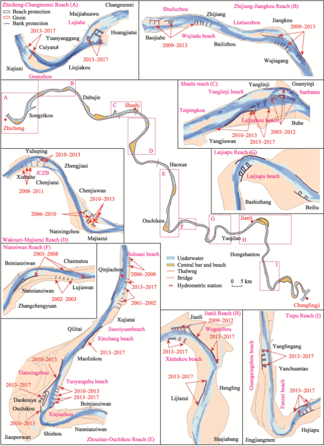
Figure 2 Layout of waterway regulation project

2.3 Data

The runoff and sediment transport rates measured at the Zhicheng, Shashi, and Jianli hydrological stations from 1955 to 2020 were collected to analyse changes in the inflow and sedimentary regime of the Jingjiang Reach. The river topography data of the Jingjiang Reach for October 2002 to October 2020 were collected to identify the changes in the distributions of scouring and siltation, scour intensity, thalweg, and beach/bar morphologies. Moreover, 2002-2020 water level data from fixed water level gauges in the Jingjiang Reach were collected. The data were combined with changes in channel depth and thalweg to elucidate the changes in the waterway dimensions in 2002-2020. Information on waterway regulation structures at the Jingjiang Reach from 2002 to 2020 was also acquired. The information is related to the position, type, dimensions, and operational status of the structures. The data were used to analyse the effects of waterway regulation projects on the bar/beach morphologies and water diversion ratios. These datasets were obtained from the Changjiang Waterway Bureau at the Changjiang Water Resources Commission and Changjiang Waterway Bureau Survey Center.

2.4 Research methodology

2.4.1 Calculation of design water level, waterway dimensions, and water diversion ratios

The ‘lowest navigable water level’, a term used in water transport engineering, denotes the lowest water level that allows for normal navigation by a standard ship or fleet. This is an important parameter in the design of waterways, wharves, and ports. The Navigation Standard of Inland Waterway (GB50139-2014) specifies that the lowest navigable water level should be determined using a synthetic flow-duration curve in reaches that are non-tidal or unaffected by tidal effects. Suppose that the water level at some cross sections of the Yangtze trunk waterway base is H0 and that the water level corresponding to the 98% navigation guarantee rate (given by the synthetic flow-duration curve) is H1; the changes in the waterway depth can be characterised as follows (Figure 3a): H1 > H0 corresponds to an increase in the lowest navigable water level, and a bed scour depth or sediment thickness less than H1-H0 corresponds to an increase in the waterway depth; furthermore, H1 < H0 corresponds to a decrease in the lowest navigable water level, and a riverbed sediment thickness or scour depth less than H1-H0 corresponds to a decrease in waterway depth.
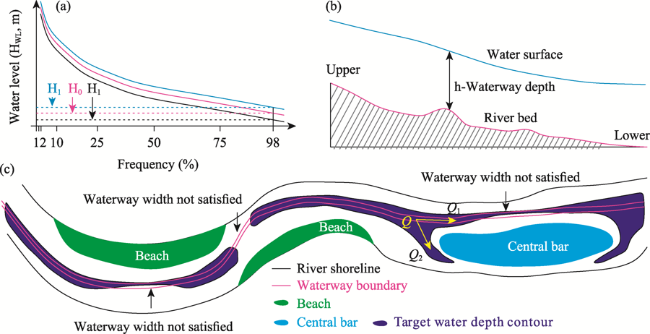
Figure 3 Calculation process of waterway depth and scale (a. Determination of lowest navigable water level; b. Waterway water depth calculation process; c. Calculation of navigation obstruction and water diversion ratios)
The dimensions of a waterway include its water depth (H), width (B), bent radius (R), and navigation clearance height (Hmax). If the water depth corresponding to the actual lowest navigable water level (h) is less than the target navigation depth H, a break will appear in the depth contour corresponding to H; that is, the insufficient water depth will result in a navigation obstacle (Figure 3b). If a location on the waterway has a depth h greater than H (i.e. the depth contour at H is not broken) but a width less than B, this location then becomes a navigation obstacle owing to its insufficient navigable width. Similarly, if R is too small for safe passage, route adjustments will lead to an insufficient waterway width and/or depth.
The water diversion ratios are calculated as follows (Figure 3c): First, the total inflow of the braided reach Q is obtained from the measured runoff at the cross section of the inlet. The water diversion ratios ηi of each branch are given as follows:
${{\eta }_{i}}\text{=}\frac{{{Q}_{i}}}{{{Q}_{1}}+{{Q}_{2}}.....{{Q}_{n}}}\times 100\text{ }\!\!%\!\!\text{ }=\frac{{{Q}_{i}}}{Q}\times 100\text{ }\!\!%\!\!\text{ };i=1,2,...,n$
where Qi is the runoff flowing into each branch (i = 1, 2, …, n, where n is the number of branches).

2.4.2 Calculation of riverbed scouring and deposition

The low-flow and bankfull channels correspond to flow rates of 5000 m3/s (Q1) and 30,000 m3/s (Q2) in the Yichang hydrological station, and the relationship between water level and flow rate is calculated according to the terrain that was surveyed in October 2002 (Figures 4a and 4b). The low-flow water level (h1) and bankfull water level (h2) (i.e. the water levels of the low-flow and bankfull channels) are determined according to the relationship between the water level and flow rate in the Jingjiang Reach. The area between the low-flow and bankfull channels is referred to as the low beach.
From the topographic cross sections of the river (Figure 4c) of the upstream and downstream watercourses of the river channels, the cross-sectional areas are calculated as
$\eta_{i}=\dfrac{Q_{i}}{Q_{1}+Q_{2}....Q_{n}}\times100\%=\dfrac{Q_i}{Q}\times100\%i=1,2,...,n$
where Ai is the cross-sectional area (m2), hi and hi+1 are the water depths of two consecutive points of a section (m), and bi is the width between two consecutive points (m).
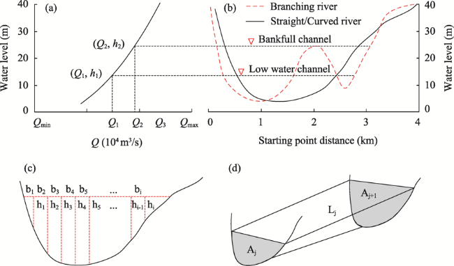
Figure 4 Calculation process of riverbed erosion and deposition (a. Water level and flow rate; b. Typical cross-sectional change; c. Section area; d. Channel capacity)
Through the truncated cone method, the volumes of the river channel Vj (Figure 4d) between the upstream and downstream sections at the corresponding water level are calculated using Eq. (3). Subsequently, the total river channel volume is obtained using Eq. (4):
${{V}_{j}}=\frac{({{A}_{j}}+{{A}_{j+1}}+\sqrt{{{A}_{j}}{{A}_{j+1}}})\times {{L}_{j}}}{3};j=0,1,2,3...,n$
$V=\sum{{{V}_{j}}}$
where Vj is the volume of the channel between adjacent sections (m3), Ai,j and Ai,j+1 are the areas of adjacent sections (m2), and Lj is the distance between adjacent sections (m).
After the calculation of the volumes V1 and V2 of the designated river channel over a two-year period and the difference between them (ΔV), the intensity of erosion/deposition (IED) in river channels per unit river length (L) and time (T) can be obtained using Eq. (5):
$V{}_{IED}\text{=}\frac{{{V}_{2}}-{{V}_{1}}}{{{L}_{river\text{ }length}}\times T}$
where VIED is the erosion and deposition intensity of the unit river length over a certain period (104 m3·km‒1·yr−1), T is the length of time (years), and Lriver length is the river length (km).

3 Research process

3.1 Relationship between erosion and deposition of riverbed and channel distribution

The cumulative scours of the low-flow channel and bankfull channel from October 1975 to October 2002 are 4.31 × 10⁸ m3 and 4.38 × 10⁸ m3 in the Upper Jingjiang Reach and 0.98 × 10⁸ m3 and 1.74 × 10⁸ m3 in the Lower Jingjiang Reach (Yang et al., 2018, 2019). Therefore, the scour was more intense in the Upper Jingjiang Reach and Lower Jingjiang Reach during this period. In the Upper Jingjiang Reach, most of the scour occurred in the low-flow channel. In the Lower Jingjiang Reach, the channel and beach were both scoured. From October 2002 to October 2020, the cumulative scours of the low-flow and bankfull channels of the Jingjiang Reach were 11.18 × 10⁸ m3 and 12.29 × 10⁸ m3, respectively, and the scour in the low-flow channel accounted for 90.95% of the bankfull channel scour. Therefore, the scour occurred both on the beach and in the channel (Figure 5a). The cumulative scours of the Upper and Lower Jingjiang Reaches accounted for 71.5% and 28.5% of the Jingjiang Reach total scour in the 1975-2002 period, 41.8% and 58.2% between October 2002 and October 2009, and 69.1% and 30.9% between October 2009 and October 2020. Therefore, the scour was significantly more intense in the Upper Jingjiang Reach than in the Lower Jingjiang Reach (Figure 5b). During these periods, October 1975-October 2002, October 2009-October 2020, and October 2002-October 2009, the low-flow channel accounted for 98.4%, 90.5%, and 96.4% in the Upper Jingjiang Reach, respectively, and 56.3%, 76.7%, and 94.3% of the bankfull channel scour in the Lower Jingjiang Reach, respectively (Figure 5c). In the 1975-2002 period before the operation of the TGD project, scours in the Lower Jingjiang Reach were mainly impacted by cut-off projects (Li et al., 2021). In the 2003-2020 period, the intensity difference of the riverbed scours and the deposition between the Upper and Lower Jingjiang Reaches were mainly related to the influence of the TGD project. Because the Upper Jingjiang Reach was closer to the TGD, its infrastructure was most directly impacted by the discharge of clear water. Accordingly, in the 2002-2009 period, the Upper Jingjiang Reach accounted for a higher proportion of scours compared with the Lower Jingjiang Reach. Since 2009, the experimental impoundment of the TGD project reached 175 m, and as the replenishing capacity of the gravelly riverbed decreased, the scour intensity of the Upper Jingjiang Reach also decreased. Owing to the cumulative downward scours of the riverbed, between 2009-2020, the scour intensity of the Lower Jingjiang Reach with a sandy riverbed was higher than those of the Upper Jingjiang Reach.
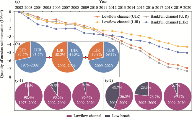
Figure 5 Relationship between erosion and deposition of riverbed and distribution of channel. (a. River bed erosion in Jingjiang Reach; b. Proportion of erosion and deposition in bankfull channel; c-1. Upper Jingjiang Reach [UJR]; c-2. Lower Jingjiang Reach [LJR])
A comparison of the thalwegs of the Jingjiang Reach among the October 2020, October 2009, and October 2002 periods (Figure 6) indicates that the sedimentary regime of the Upper Jingjiang Reach was dominated by scour. The Lower Jingjiang Reach alternated between scouring and deposition, although scouring was dominant. From October 2002 to October 2020, the thalweg of the Jingjiang Reach deepened by 2.97 m on average, with a maximum scour depth of 20.10 m in the Tiaoguan Reach. According to the lowest navigable water level that corresponded to the 98% navigation guarantee rate and the terrain in October 2020, the lowest navigable water level of the Upper Jingjiang Reach was lower than the current navigation base level (i.e., in 2022). The largest decrease in the lowest navigable water level (2.01-2.49 m) occurred in the Yuanshi-Majiazui Reach. In contrast, the lowest navigable water level of the Lower Jingjiang Reach was higher than the current navigation base level. At the downstream end of the Lower Jingjiang Reach (Chenglingji), the lowest navigable water level in 2020 was 1.79 m higher than that in 2002. A comparison of 2002 with 2020 revealed that the sedimentary regime of the Upper Jingjiang Reach was dominated by thalweg. The lowest navigable water levelin 2002 was higher that in 2020 and the current navigation base level. The thalweg of the Lower Jingjiang Reach alternated between scours and deposition. The lowest navigable water level increased over the years and was higher than the navigation base level. In the 2002-2020 period, ~94.9% and ~85.2% of the scours were concentrated in the low-flow channels in the Upper and Lower Jingjiang Reaches, respectively, so that the riverbed scours in the Upper Jingjiang Reach had a great impact on the falling of the low-flow water level. According to the above-described analysis, the imbalanced scour distributions in the Upper and Lower Jingjiang Reaches and the varied extents of the impact of the TGD project operation were the main reasons for the difference in the lowest navigable water level between the Upper and Lower Jingjiang Reaches.
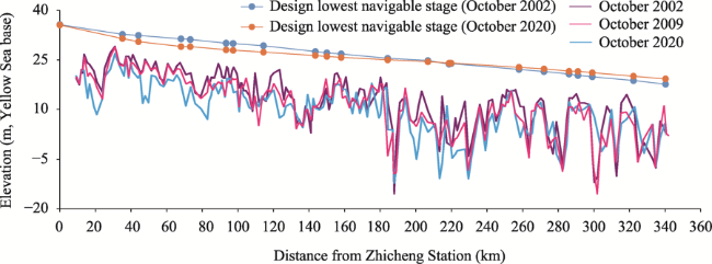
Figure 6 Relationship between thalweg and water level change

3.2 Changes in bar and beach boundaries of the waterway

Compared with the 2002 overall area of central bars and beaches in the Jingjiang Reach, the 2019 area was lower by 18.3% (13.9% in the section with the gravelly riverbed, 27.4% in the Shashi Reach, 10.45% in the Yanka-Ouchikou Reach, and 15.7% in the Lower Jingjiang Reach) (Figure 7 and Table 2). The areas of beaches and central bars in 2019 were 24.9% and 9.4% lower than those in 2002, respectively. The areal changes in beaches and central bars in braided reaches were divided into four patterns: continuous decrease, increase and then decrease, decrease and then increase, and continuous increase. The central bars and beaches whose areas continuously decreased include Luijiahe, Huojianzhou, Mangyangzhou, Jinchengzhou, Jiaoziyuan, Xinchang, Tuoyangshu, Taioguan, Guangxingzhou, Guanzhou, Qigongling, and Guanyinzhou. In the Huojianzhou and Mayangzhou central bars, waterway regulation projects have not been implemented in the reaches since 2002, and their areas have continuously decreased, because of the discharge of clear water. The areas of the Lujiahe central bar, Jinchengzhou beach, Jiaoziyuan beach, Xinchang beach, Tuoyangshu beach, Tiaoguan beach, Guangxingzhou beach, and Guanzhou beach have continuously decreased despite the implementation of waterway regulation projects. Although the beaches and grooves have been stabilised by these projects, they are strongly affected by the discharge of clear water owing to their proximity to the dam. Consequently, the central bars and low beaches in these areas have continuously shrunk. The central bars and beaches whose areas initially decreased and then increased include the Guanzhou central bar, Zhangjiataoyuan beach, Wujiadu beach, Sanbatan central bar, Daokouyao central bar, Xiangjiazhou beach, Laijiapu beach, and Wuguizhou central bar. The areas of these beaches and central bars have increased, owing to the implementation of river training and waterway regulation projects. Thus, their shrinkage was successfully reversed by engineering projects implemented by humans. The beaches and central bars whose areas first increased and then decreased include the Liutiaozhou central bar, Shuiluzhou central bar, Taipingkou central bar, and the Jiuhuasi beach. The sandy areas increased after the completion of waterway regulation projects, but their low beaches were still being scoured. Therefore, further work must be performed to ensure the integrity of these areas in waterway expansion works. The Nanxingzhou central bar was the only central bar whose area has increased continuously, attributable to the continuous implementation of waterway regulation projects (Figure 2d) in the Wakouzi Reach, which have successfully protected the integrity of the central bar.
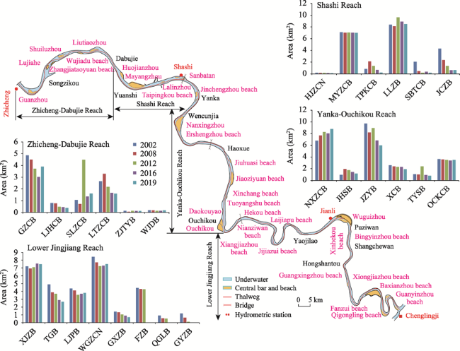
Figure 7 Areas of beach and central bar
Table 2 Areas of central bar and beach
Year 2002 2008 2012 2016 2019
Central bar (km2) 38.39 37.96 38.51 33.37 34.79
Beach (km2) 51.79 46.01 46.97 41.20 38.91
Area of central bar and beach (km2) 90.18 83.97 85.48 74.57 73.7

3.3 Changes in dry-season water diversion ratios

The braided reaches of the Jingjiang Reach are located at the Guanzhou, Lujiahe, Liutiaozhou, Taipingkou, Sanbatan, Nanxingzhou, Daokouyao, and Wuguizhou central bars. The waterways of different reaches were constructed at different times, and several constructions had poor adaptability to water changes and sand conditions. However, the regulation of beach and trough morphologies through the waterway projects was still insufficient, which was one of the causes of the unstable diversion ratios of several braided reaches. The changes in the dry-season water diversion ratios of the braided reaches are presented as follows (Figure 8):
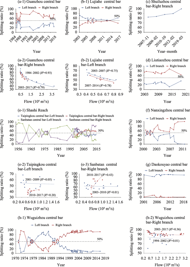
Figure 8 Variation in the water diversion ratios of the main branch
(1) Guanzhou braided reach (Figure 8a): From 1984 to 1987, the changes in the water diversion ratios at the Guanzhou central bar were large, because the main and tributary branches exchanged paths within a few years. The water diversion ratios of this reach did not significantly change from 1987 to 2002, but the water diversion ratios of the left branch increased over 2002-2016. The water diversion ratio per the flow rate of the right branch in the 2003-2017 period was lower than those in the 1984-2002 period. After the implementation of a waterway regulation project in the Jingjiang Reach, the water diversion ratio of the left branch increased. The water diversion ratio in 2017 (when the flow rate in the Zhicheng hydrological station was 6404 m3/s) was 10.1% higher than that in 2012 (when the flow rate at the Zhicheng hydrological station was 6027 m3/s).
(2) Lujiahe braided reach (Figure 8b): The water diversion ratios of the left branch decreased over 2003-2014, and the water diversion ratio per flow rate of the left branch in 2007-2014 was lower than that in 2003-2007. After the completion of the waterway regulation project in the Jingjiang Reach, the water diversion ratio of the left branch increased. The ratio in 2016 (when the flow rate at the Zhicheng hydrological station was 6058 m3/s) was 10.9% higher than that in 2014 (when the flow rate at the Zhicheng hydrological station was 6347 m3/s).
(3) Shuiluzhou braided reach (Figure 8c): The water diversion ratios of the right branch have been increasing since 2007. In March 2019, the left branch stopped flowing during the dry season.
(4) Liutiaozhou braided reach (Figure 8d): The water diversion ratios of the Liutiaozhou central bar did not significantly change during the 2003-2010 period, and the water diversion ratio between the left and right branches were 3:7. In the 2011-2014 period, the water diversion ratios of the right branch increased, which indicates that the waterway regulation project restricted the water diversion ratios of the left branch. The bed scour in the left branch was significant from 2014 to 2019, because the water diversion ratios of the right branch decreased by ~25% during this period.
(5) Shashi Reach (Figure 8e): The Shashi Reach has two braided sections, namely the Taipingkou and Sanbatan central bars. In both central bars, the main and tributary branches exchanged paths during the dry season. At the Taipingkou braided reach, this process occurred between 2004 and 2006, and in 2006, the right branch became the main branch. At the Sanbatan braided reach, dry-season swapping between the main and tributary branches occurred three times: in 1978-1980, 1999-2000, and 2010-2011. The water diversion ratios of the left branch in Taipingkou in 2010-2017 were significantly lower than those in 2001-2009. Compared with the 2003-2010 period, the 2010-2017 period featured higher water diversion ratios of the right branch in Sanbatan during floods and lower ratios during the dry season.
(6) Nanxingzhou braided reach (Figure 8f): The water diversion ratios of this braided reach considerably changed in the 2000-2011 period. From 2000 to 2001, the water diversion ratios of the left and right branches were similar, but over 2002-2007, the water diversion ratios of the right branch first increased and then decreased. After the implementation of the waterway regulation projects, the water diversion ratios of the right branch considerably increased over the years, and a point was reached when the left branch was dry during the dry season.
(7) Daokouyao braided reach (Figure 8g): The water diversion ratios of this braided reach were stable until the implementation of a waterway regulation project, which greatly increased the water diversion ratios of the left branch (by almost 100%). The right branch was dry during dry seasons.
(8) Wuguizhou braided reach (Figure 8h): At the Wuguizhou central bar, two exchanges between the main and tributary branches have occurred since 1970, i.e., in the 1977-1979 and 1990-1993 periods. The water diversion ratios of the right branch have been increasing since 1994, and its water diversion ratios per flow rate in 2003-2017 were higher than those in 1994-2002. This shows that the waterway regulation projects implemented after TGD impoundment have effectively regulated the water diversion ratios.
The time elapsed since the commissioning of the TGD can be divided into two periods: the first period was from TGD impoundment to the instant before the implementation of the waterway regulation projects, and the second period was from the completion of the waterway regulation projects to the present day. In the first period, the left branch of the Guanzhou central bar (2014-2017), right branch of the Luisah central bar (2003-2014), right branch of the Shuiluzhou central bar (2007-2012), left branch of the Liutiaozhou central bar (2003-2010), right branch of the Nanxingzhou central bar (2004-2007), left branch of the Daokouyao central bar (2001-2009), and right branch of the Wuguizhou central bar (2003-2007) showed an increase in water diversion ratios at the same flow rate. All of these branches exhibited one similarity: they were shorter than the opposite branch. In the second period, the water diversion ratios of the left branch of the Guanzhou central bar (since 2014), right branch of the Lujiahe central bar (since 2014), right branch of the Shuiluzhou central bar (since 2012), left branch of the Liutiaozhou central bar (2012-2014), right branch of the Nanxingzhou central bar (since 2007), left branch of the Daokouyao central bar (since 2009), and right branch of the Wuguizhou central bar (since 2007) have all increased. This shows that the waterway regulation projects have achieved their goals. The Taipingkou and Sanbatan braided reaches in the Shashi Reach are straight and slightly curved, respectively, and their evolutionary processes are closely interconnected to the upstream and downstream areas of beaches and bars. Furthermore, the braided reaches have been affected by numerous human interventions, including waterway regulation projects, the construction of the Jingjiang Yangtze River Bridge, and sand mining activities (Hu et al., 2020; Zhao et al., 2020; Yang et al., 2021). Consequently, the main and tributary branches of the braided reaches frequently interchanged paths, and unlike other braided reaches, the water diversion ratios of the shorter branch did not increase after TGD commissioning.

4 Results and discussion

4.1 Analysis of requirements for waterway expansion

In 2002, the dimensions of the Jingjiang Reach waterway were 2.9 m × 40 m × 300 m (for the 95% navigation guarantee rate). Owing to the implementation of waterway regulation projects in 2020, the waterway dimensions of the Zhicheng-Changmenxi, Changmenxi-Jingzhou and Jingzhou-Chenglingji reaches were 3.5 m × 100 m × 750 m, 3.5 m × 150 m × 1000 m, and 3.8 m × 150 m × 1000 m, respectively. This allowed the Jingjiang Reach to obtain a 98% navigation guarantee rate all year round (Figure 9). The combined waterway of the Jingjiang Reach had water depths of 3.5-3.8 m, which were shallower than those of the upstream TGD reservoir area (4.5 m) and the downstream Chenglingji-Wuhan (4.2 m) and Wuhan-Anqing (6.0 m) reaches. Because of this mismatch in water depths, increasing the water depth of the Jingjiang Reach to 4.5 m will allow for the full connection of the Yangtze upstream and downstream waterways, which will significantly improve transportation efficiency in the Yangtze River ‘Golden Waterway’.
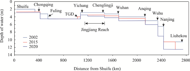
Figure 9 Water depth change of the main waterway of the Yangtze River
Over 2005-2020, the waterway freight volume of the Yangtze River trunk line continuously increased. Specifically, the volume increased from 942 million tons per year in 2005 to 3.06 billion tons per year in 2020, with an average annual growth rate of 8.6% (Figure 10). In 2017-2020, the first-phase project of the Jingjiang Reach, the waterway regulation project of the Wuhan-Anqing Reach at a water depth of 6 m, and the second-phase project of the 12.5 m deep-water waterway below Nanjing were put into operation. The growth rate of the freight volume on the trunk line of the Yangtze River gradually increased over the years. In 2013-2016, the value was lower than the gross domestic product growth rate, but in 2017-2020, it was higher than the gross domestic product growth rate, indicating that the Yangtze River trunk line features high competitiveness in low-cost water transportation and strong freight demand. In 2005-2018, the net load of water transport vessels in the Yangtze River Basin increased by 167.0%, and the number of vessels decreased by 40% yearly; this corresponds to a significant trend for larger vessels. Therefore, there is an urgent need to increase the waterway scale to meet the requirement of increased freight and larger vessels.
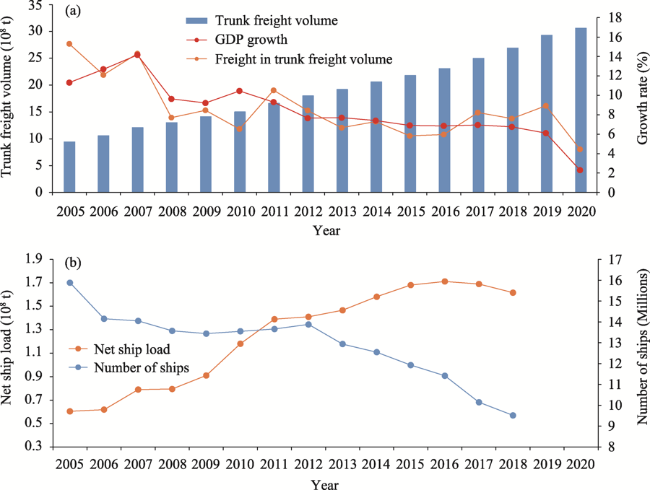
Figure 10 Increasing freight and development of bigger vessels (a. Trunk freight volume of the Yangtze River; b. Ship capacity)

4.2 Inspection of waterway conditions

The water depths of the Jingjiang Reach waterway were tallied according to the river topography that was surveyed in October 2020 (Figure 11). Given a waterway width of 200 m, there were 14 waterways with water depths less than 4.5 m in the Jingjiang Reach: the Guanzhou, Lujiahe, Zhijiang, Jiangkou, Dabujie, Yuanshi, Taipingkou, Wakouzi, Zhougongdi, Jianli, Damazhou, Tiepu, Chibakou, and Guanyinzhou waterways. The minimum water depths of the remaining 19 waterways were > 4.5 m. After drawing a 4.5 m-depth contour through the Jingjiang Reach, it was revealed that there were 13 waterways with widths of < 200 m: the Zhicheng, Guanzhou, Lujiahe, Zhijiang, Jiangkou, Dabujie, Yuanshi, Taipingkou, Wakouzi, Zhougongdi, Jianli, Damazhou, and Guanyinzhou waterways. The other 20 waterways had widths of > 200 m on their 4.5 m-depth contours. Given a waterway scale of 4.5 m × 200 m, the Jingjiang Reach is either insufficiently wide or deep in the Guanzhou, Lujiahe, Zhicheng, Jiangkou, Dabujie, Yuanshi, Taipingkou, Wakouzi, Zhougongdi, Jianli, Damazhou, Chibakou, and Guanyinzhou waterways. These navigation-hindering channels account for 5.3% of the total length of the Jingjiang Reaches (18.4 km).
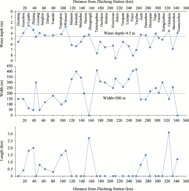
Figure 11 Verification of waterway conditions (a. Minimum water depth in 200 m waterway; b. Minimum width of 4.5 m water depth line; c. Length of waterway scale less than 4.5 m × 200 m)

4.3 Characteristics of navigation hindrances and their relation to river evolution

4.3.1 Navigation hindrances due to non-uniform decrease in water level

The water levels of the Jingjiang Reach, which correspond to a flow rate of 6000 m3/s at the Yichang hydrological station during the 2003-2020 period, are shown in Figures 12a and 12b. In 2003-2009, the decrease in the water level at the fixed water level gauges of the Jingjiang Reach ranged from 0.06 to 0.53 m; the decreases in water level at the Yichang-Zhicheng Reach and downstream reaches of Zhijiang were greater than those in the Zhicheng-Zhijiang Reach. In 2009-2020, the decrease in the water levels of the Jingjiang Reach ranged from 0.27 m to 2.66 m. The water level decreases were large in the Changmenxi-Shishou Reach (downstream end of the Upper Jingjiang Reach), but relatively small in the Yichang-Changmenxi Reach and Lower Jingjiang Reach. From 2003 to 2020, the average thalweg depth of the Upper Jingjiang Reach increased by 2.97 m, while the corresponding water level decreased by an average of 1.21 m (0.27-2.66 m). Because the average decrease in water level was less than the average increase in the thalweg depth, the water depth of the waterway increased in 2003-2020.
The annual average decrease in the water level in 2009-2020 was smaller than that in 2003-2020 in the Yichang-Zhicheng Reach, considerably larger in the Upper Jingjiang Reach, and smaller in the Lower Jingjiang Reach. The 4.5 m-depth contour extended to near the Changmenxi and Caojiahe-Wujiadu reaches, but their widths were less than 150 m. In the Lijiadu-Zhangjiataoyuan and Qixingtai reaches, there were breaks in the 4.5 m-depth contour (Figure 12c). In 2009-2020, the water levels of the Changmenxi-Dabujie Reach decreased by 2.21 m, but the corresponding deepening of the thalweg was only 1.61 m on average. Thus, the decrease in the water level was greater than the deepening of the thalweg. This led to the occurrence of a navigation obstacle in the Changmenxi-Dabujie Reach. In the sandy pebble reaches near the dam, the decrease in equal-flow to low-flow levels in 2018-2019 was considerably smaller than that in 2003-2018 (Li et al., 2021), which was favourable for the implementation of channel dredging measures. The lowest discharge of the Three Gorges Reservoir was increased (Yang et al., 2017; Yang et al., 2019) and the flow compensation directly increased the water level of the sandy pebble reaches in the dry season. This provides a favourable condition for increasing waterway depth. High-gradient streams have a substantial impact on the navigation environment (Li et al., 2021).
Figure 12 Waterway water depth conditions of sand cobble reach (a. Water level of Jingjiang Reach corresponding to a Yichang hydrological station discharge of 6000 m3/s; b. Variation of water level; c. Waterway conditions at a depth of 4.5 m from the Changmenxi-Dabujie Reach)

4.3.2 Navigation obstacles due to unstable beach areas in curved sections

The curved sections in the Jingjiang Reach are abrupt bends. For example, the Tiaoguan-Laijiapu (22.5 km long) and Yangjianao-Chenglingji reaches (45.1 km long) have a curvature of 2.65. Zhu et al. (2017a) studied the distributions of scouring and deposition in these riverbeds from 2002 to 2012. In the current study, we analysed the 2012-2020 distributions of scouring and deposition in the riverbed (Figure 13) and found that scouring occurred on convex banks, while deposition occurred on concave banks. This trend is consistent with the findings by Zhu et al. (2017a). Owing to water flow regulation by the reservoir and the consequent redistribution of flow rates in the Lower Jingjiang Reach, the heterogeneity of the hydrodynamic axis actions on the convex and concave banks has increased over time. Specifically, this has considerably extended the duration in which the convex bank remains within the mainstream compared with the concave bank and has exacerbated erosion in the convex bank (Han et al., 2017b; Zhu et al., 2017b). The convex bank erosion reduced the bend radius of the waterway, which made it difficult for ships to safely navigate the bend. Although the 4.5 m-depth contour is continuous in the Tiaoguan-Laijiapu Reach of the Jingjiang Reach, the decrease in the bend radius can pose as a navigation risk.
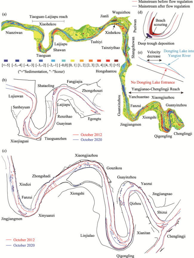
Figure 13 Water depth conditions of bend channel. (a. Distribution of scouring and silting in river bed in October 2012-October 2020; b. Tiaoguan-Laijiapu Reach; c. Yanchuantao-Chenglingji Reach; d. Variation characteristics of beach trough; e. Influence of confluence of the water level of Dongting Lake)
The Yangjianao-Chenglingji Reach consists of four continuous abrupt bends. The Fanzui waterway has a small bending radius, while the Xiongjiazhou, Chibakou, Baxianzhou, and Guanyinzhou reaches contain scattered sections with water depths of < 4.5 m owing to outflows from the Dongting Lake (Lai et al., 2013).

4.3.3 Navigation hindrances due to unstable bars and water diversion ratios in braided reaches

Because the water diversion ratios can change with flow rate, the main and tributary branches of the braided reach may either alternate seasonally or not alternate at all. The seasonally alternating braided reaches are the Guanzhou, Lujiahe, Taipingkou-Sanbatan, and Wuguizhou, and the non-alternating reaches are the Shuiluzhou, Huojianzhou, Mayangzhou, Nanxingzhou, and Daokouyao. After the implementation of waterway regulation projects, the Wuguizhou braided reach transformed from a seasonally alternating into a non-alternating reach. The navigation-hindering characteristics of the braided reaches are described below (Figure 14).
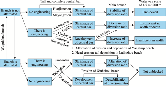
Figure 14 Relationships between beach evolution, water diversion ratios, and waterway conditions
(1) Braided reaches with channels that do not contain any significant beaches are numerous, and include the Guanzhou, Lujiahe, Shuiluzhou, Liutiaozhou, Huojianzhou, Mayangzhou, Nanxingzhou, and Daokouyao braided reaches. Waterway regulation projects have not been implemented in the Huojianzhou and Mayangzhou reaches because their central bars and beaches have high elevations and are well preserved. Thus, the reaches show only small decreases in the area. Furthermore, the dry-season water diversion ratios of the main channels are greater than 80%, and the small amount of scouring in the central bars slightly affects the water diversion ratios. The 4.5 m-depth contour is also continuous in the reaches. Although the positions of the Liutiaozhou and Lujiahe central bars stabilised after the implementation of the waterway regulation works, their areas and dry-season main branch both decreased over time, and the resulting widening of the inlet sections led to insufficient water depths (< 4.5 m) or channel widths. After the installation of the bottom protection structures in the left branch of the Guanzhou central bar, the central bar area increased. However, the dry-season water diversion ratios of the main branch have decreased over time. Consequently, the main branch is insufficiently deep or wide for navigation under a low hydrodynamic force at the inlet. The implementation of waterway regulation projects has increased the areas of the Daokouyao and Nanxingzhou central bars and stabilised their dry-season water diversion ratios. However, according to the terrain that was surveyed in October 2020, several parts of the 4.5 m-depth contour are insufficiently wide for safe navigation at these reaches.
(2) Braided reaches with multiple central bars and beaches whose changes are strongly correlated with one another, such as the Shashi and Jianli reaches. The Shashi Reach contains the Taipingkou central bar, Lalinzhou beach, Sanbatan central bar, and Yanglinji beach (which only appears in specific years). Only a few waterway regulation projects have been implemented in this area, particularly at the Sanbatan central bar and Lalinzhou beach (Figure 15). The waterway regulation projects were implemented in 2001-2020. During this period, dry-season switching between the main and tributary branches occurred in the Taipingkou and Sanbatan central bars. Therefore, waterway regulation projects are directly related to the evolution of central bars and beaches in the reaches. According to the water diversion ratios and bar morphologies in 2001-2003, the southern branch of the Taipingkou central bar had a water diversion ratio of 41%. Furthermore, 25% of the runoff from the Taipingkou central bar northern branch flowed from a channel sandwiched by the tail of the Taipingkou central bar and the head of the Sanbatan central bar into the southern branch of the Sanbatan central bar. Consequently, the southern branch of the Sanbatan central bar was the main branch from 2001 to 2003. In the 2004-2006 period, scouring and deposition occurred at the head and tail of the Lalinzhou beach, respectively, which increased the water diversion ratios of the Taipingkou central bar southern branch. Furthermore, the changes in the morphology of the Lalinzhou beach caused the flow to swing towards the northern branch of the Sanbatan central bar, which induced substantial scouring in the Sanbatan central bar. Over 2007-2013, the scouring and deposition at the head and tail of the Lalinzhou beach continuously increased, and the Taipingkou central bar began to shrink. These processes increased the average water diversion ratios of the Taipingkou central bar southern channel to 59%. During this period, ~11% of the runoff flowed through the channels between the tail of the Taipingkou central bar and the head of the Sanbatan central bar into the Sanbatan central bar northern branch; this caused switching between the main and tributary branches in the dry season for the first time. In 2014-2018, the weakening in the hydrodynamic force due to previous decreases in the water diversion ratios of the Taipingkou central bar northern branch caused a considerable increase in the area of the Yanglinji beach. The Lalinzhou beach also shielded the Yanglinji beach from erosion, which stabilised the head of the Lalinzhou beach while allowing deposition at the tail. The expansion of the Lalinzhou beach and the shrinkage of the Sanbatan central bar caused the water diversion ratios of the Sanbatan central bar southern branch to increase by > 50%, thus completing another exchange between the main and tributary branches. The Jianli Reach, which contains the Wuguizhou central bar and Xinhekou beach, has undergone multiple river training and waterway regulation projects. Because changes in the Wuguizhou central bar and the Xinhekou beach are related, the water diversion ratios of the Wuguizhou central bars branches are unstable; this causes the groove of the Wuguizhou central bars right branch to overlap with those of the Damazhou Reach. The overlapping areas between the grooves had water depths of < 4.5 m and an uneven route.
Figure 15 Relationships between beach evolution and branch diversion ratio in Shashi Reach

4.4 Relationship between waterway expansion and ecological environment

The development of shipping functions is an important aspect of watershed resource utilisation. However, the use of natural scouring alone to deepen waterways is associated with a large amount of uncertainty, and there is a certain limit regarding the water depth that can be obtained in this way. Waterway expansion is needed to satisfy the growing demands of shipping. The expansion is often implemented through the construction of reservoirs (Yang et al., 2019), spur dikes (Yang et al., 2019) and canalised rivers (Wan et al., 2014; Wu et al., 2016) and dredging (Ford et al., 2013; Hajdukiewicz et al., 2016; Suedel et al., 2021). Reservoir construction will directly increase waterway depth in the reservoir area (Moretto et al., 2014; Smith et al., 2016). The regulatory functions of the reservoir can increase the minimum flow rate during dry seasons, thereby increasing water level and depth (Chai et al., 2021). Dredging is also a vital part of waterway regulation, but it often leads to rapid back-siltation (Helal et al., 2020). Therefore, maintaining a waterway through dredging may be costly (Ahadi et al., 2018). However, the implementation of waterway regulation projects or dredging works could lead to ecological damage, and environmental recovery will increase economic costs (Bernhardt et al., 2005; Szałkiewicz et al., 2018; Logar et al., 2019). The systematic development of most rivers across the world, including the Mississippi River (Yu, 2005), Rhine River, (Quick et al., 2020) and Yangtze River Estuaries (Wan et al., 2014; Wu et al., 2016), considerably increases the sizes of their waterways.
The Jingjiang Reach consists of 124 sluices and drainage outlets (~5.6 km per sluice or outlet), and the Jingzhou Port consists of 16 port areas that cover 59.01 km of the shore (i.e., 17% of the Jingjiang Reach). Four bridges span the Jingjiang Reach, and they are located in the Zhicheng, Taipingkou, Haoxue, and Nianziwan waterways. The frequent exchange between the main and tributary branches in the Taipingkou waterway is partially due to the construction of the Jingzhou Yangtze River Bridge. Thirty-six river-crossing or steam ferries occur along the Jingjiang Reach, and their density along the coastline is ~10.4 km/ferry. The water-related facilities overlap on the reach. Because waterway regulation projects must minimise their impact on water-related facilities, they are difficult to implement. However, using dredging alone to achieve water depth targets is costly, and annual maintenance is vital for navigation safety. Furthermore, the Jingjiang Reach is an important area of activity for the Yangtze Finless Porpoise, and the Tian'ezhou National Nature Reserve is located in this reach (Figure 16). The nature reserve protects the Tianxingzhou, Daokouyao, and Nianziwan waterways, and the implementation of waterway regulation projects in these areas is highly restricted.
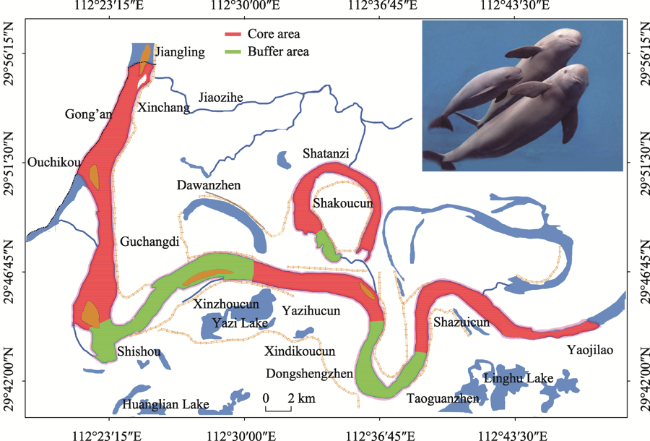
Figure 16 Tianezhou Dolphin National Nature Reserve of Yangtze River in Hubei Province
Waterway regulation projects have been systematically implemented on the Yangtze River trunk line using various environmentally friendly structures, including tetrahedral frames (Wang et al., 2017; Xing et al., 2021), dolosse (Cao et al., 2018), W-shaped dams (Huang et al., 2019), ‘fish tank’ bricks (Cao et al., 2018; Wang et al., 2020a), D- and X-shaped rows, and grass-planting and sand-fixing structures (Li, 2018; Fan et al., 2020). According to long-term observations since 2013, these structures have had a significant positive effect on the ecological environment of the Yangtze River (Li et al., 2017; Li et al., 2018b). Onsite monitoring results have revealed that after the implementation of the first-phase project of the Jingjiang Reach, vegetation in the high beach increased considerably. For example, the Daokoujiao central bar has gradually transformed from a bear bar into a lush-vegetation area (Li, 2018), the growth of vegetation effectively stabilized the beach. Fish abundance near the constructions has also increased, and benthos has been recovered (Liu et al., 2016; Liu et al., 2021). The ecological restoration measures adopted by the waterway channel project with a 12.5 m depth below Nanjing, including artificial fish nests and ecological floating beds, have had significant effects, because the floating bed plants have been significantly growing and the number of planktons in fish nests has been increasing (Cao et al., 2018). In the planning of waterway regulation projects to increase the Jingjiang Reach waterway depth to 4.5 m, considering novel environment-friendly waterway regulating structures is vital to ensure that the ecological environment of the Jingjiang Reach benefits from the projects.

5 Conclusions

This study aimed to expand the waterway dimensions of the Jingjiang Reach. Thus, it was necessary to determine the relationship between the river evolution processes and the potential for waterway depth improvement and navigation hindrances.
Since the TGD began to hold back water, scouring in low-flow channels has accounted for 93.1% of the scouring in the Jingjiang Reach, which is beneficial for increasing waterway dimensions. The total area of central bars and beaches in the Jingjiang Reach has decreased by 18.3%, with the former and latter decreasing by 9.4% and 24.9%, respectively. This destabilises waterway boundaries. In a braided reach with large and intact central bars, the dry-season water diversion ratios of their branches tend to be stable. Conversely, in a braided reach with beaches and central bars, the water diversion ratios of their branches are often unstable. Thus, in the section of the Upper Jingjiang Reach with a gravelly riverbed, the decrease in the water level is greater than the downcutting of the riverbed. This has resulted in an insufficient depth of the waterway. Owing to convex bank scouring and concave bank deposition in the curved section, several abrupt bends have a small radius, which hinders safe passage. The shrinkage of beaches and central bars in braided reaches, which are often strongly interconnected, has resulted in unstable dry-season water diversion ratios and swapping between the main and tributary branches during the dry season. According to the current terrain of the Jingjiang Reach (which was surveyed in October 2020), navigation-hindering channels account for 5.3% of the 4.5 m × 200 m × 1050 m waterway of the Jingjiang Reach. To improve waterway depth, attention should be given to the scouring and deposition patterns of the Jingjiang Reach, changes in its central bars and beaches, and the water diversion ratio trends of the braided reaches. Although the Jingjiang Reach satisfies all of the requirements for further water depth improvement, considering the environmental effects of the waterway project is vital.
[1]
Ahadi K, Sullivan K M, Mitchell K N, 2018. Budgeting maintenance dredging projects under uncertainty to improve the inland waterway network performance. Transportation Research Part E: Logistics and Transportation Review, 119(C): 63-87.

[2]
Bernhardt E S, Palmer M A, Allan J D et al., 2005. Synthesizing U.S. river restoration efforts. Science, 5722(308): 636-637.

[3]
Cao F S, Xiao X, Wu P, 2010. Yangtze River: China’s golden waterway. Civil Engineering, 163(5): 15-18.

[4]
Cao M X, Shen X, Huang Z B et al., 2018. Techniques of ecological and protection based on deepwater navigation channel project in the Yangtze River below Nanjing. Port & Waterway Engineering, 544(7): 1-9. (in Chinese)

[5]
Chai Y F, Li Y T, Yang Y P et al., 2019. Influence of climate variability and reservoir operation on streamflow in the Yangtze River. Scientific Reports, 9(1): 5060.

DOI PMID

[6]
Chai Y F, Yang Y P, Deng J Y et al., 2020. Evolution characteristics and drivers of the water level at an identical discharge in the Jingjiang reaches of the Yangtze River. Journal of Geographical Sciences, 30(10): 1633-1648.

DOI

[7]
Dai Z J, Liu J T, 2013. Impacts of large dams on downstream fluvial sedimentation: An example of the Three Gorges Dam (TGD) on the Changjiang (Yangtze River). Journal of Hydrology, 480(4): 10-18.

DOI

[8]
Dai Z J, Mei X F, Stephen E et al., 2018. Fluvial sediment transfer in the Changjiang (Yangtze) River estuary depositional system. Journal of Hydrology, 566(1): 719-734.

DOI

[9]
Deng S S, Xia J Q, Zhou M R et al., 2018. Coupled modeling of bank retreat processes in the Upper Jingjiang Reach, China. Earth Surface Processes and Landforms, 43(14): 2863-2875.

DOI

[10]
Deng S S, Xia J Q, Zhou M R et al., 2019. Coupled modeling of bed deformation and bank erosion in the Jingjiang Reach of the middle Yangtze River. Journal of Hydrology, 568: 221-233.

DOI

[11]
Fan Y J, Yang Z H, Zou M Z et al., 2020. Evaluation of ecological effect of steel wire mesh stone cage revetment in middle and lower reaches of the Yangtze River. Port & Waterway Engineering, 578(1): 129-135. (in Chinese)

[12]
Fang H W, Han D, He G J et al., 2012. Flood management selections for the Yangtze River midstream after the Three Gorges Project operation. Journal of Hydrology, 432/433(8): 1-11.

DOI

[13]
Ford M R, Becker J M, Merrifield M A, 2013. Reef flat wave processes and excavation pits: Observations and implications for Majuro Atoll, Marshall Islands. Journal of Coastal Research, 29(3): 545-554.

[14]
Gao C, Jin C W, Guo L C et al., 2020. On the cumulative dam impact in the upper Changjiang River: Streamflow and sediment load changes. Catena, 184: 104250.

DOI

[15]
Hajdukiewicz H, Wyżga B, Mikuś P et al., 2016. Impact of a large flood on Mountain River habitats, channel morphology, and valley infrastructure. Geomorphology, 272(SI):55-67.

DOI

[16]
Han J Q, Sun Z H, Li Y T et al., 2017a. Combined effects of multiple large-scale hydraulic engineering on water stages in the middle Yangtze River. Geomorphology, 298: 31-40.

DOI

[17]
Han J Q, Zhang W, Fan Y Y et al., 2017b. Interacting effects of multiple factors on the morphological evolution of the meandering reaches downstream the Three Gorges Dam. Journal of Geographical Sciences, 27(10): 1268-1278.

[18]
Hassan M A, Church M, Yan Y et al., 2010. Spatial and temporal variation of in-reach suspended sediment dynamics along the mainstem of Changjiang (Yangtze River), China. Water Resources Research, 46(11): W11551.

[19]
He Q H, Yu D Q, Wang L C et al., 2020. Evolution process and characteristics of lower Jingjiang paleo-channel in recent 400 years. Earth Science, 45(6): 1928-1936. (in Chinese)

[20]
Helal E, Elsersawy H, Hamed E et al., 2020. Sustainability of a navigation channel in the Nile River: A case study in Egypt. River Research and Applications, 36(9): 1817-1827.

DOI

[21]
Hijdra A, Arts J, Woltjer J, 2014. Do we need to rethink our waterways? Values of ageing waterways in current and future society. Water Resources Management, 28(9): 2599-2613.

DOI

[22]
Hu P, Lei Y H, Deng S Y et al., 2020. Role of bar-channel interactions in a dominant branch shift: The Taipingkou waterway, Yangtze River, China. River Research and Applications, 37(3): 494-508.

DOI

[23]
Huang T J, Lu Y, Liu H X, 2019. Effects of spur dikes on water flow diversity and fish aggregation. Water, 11(9): 1822.

DOI

[24]
Juez C, Garijo N, Hassan M A et al., 2021. Intraseasonal-to-interannual analysis of discharge and suspended sediment concentration time-series of the Upper Changjiang (Yangtze River). Water Resources Research, 57(8): e2020WR029457.

[25]
Lai X J, Jiang J H, Liang Q H et al., 2013. Large-scale hydrodynamic modeling of the middle Yangtze River Basin with complex river-lake interactions. Journal of Hydrology, 492: 228-243.

DOI

[26]
Li D F, Lu X X, Chen L et al., 2019. Downstream geomorphic impact of the Three Gorges Dam: With special reference to the channel bars in the Middle Yangtze River. Earth Surface Processes and Landforms, 44(13): 2660-2670.

DOI

[27]
Li M, 2018. Research on the ecological shoal consolidation methods in river central bar protection: Taking the implantable ecological shoal consolidation engineering in Yangtze River Daokouyao Channel Bar as on example. China Rural Water and Hydropower, (7): 78-83. (in Chinese)

[28]
Li M, Hu C H, Zhou C C et al., 2021. Analysis on the evolution mechanism of the “steep slope and rapid flow” section of Lujia waterway in the middle reaches of the Yangtze River under new conditions of water and sediment. Journal of Hydraulic Engineering, 52(2): 158-168. (in Chinese)

[29]
Li S X, Yang Y P, Zhang H Q et al., 2021. The scouring and siltation in river channels of the middle reaches of the Yangtze River (1975-2017) before/after the Three Gorges Project.. Journal of Lake Sciences, 33(5): 1520-1531. (in Chinese)

DOI

[30]
Li S Z, Yang Y P, Zhang M J et al., 2018a. Coarse and fine sediment transportation patterns and causes downstream of the Three Gorges Dam. Frontiers of Earth Science, 12 (4): 750-764.

DOI

[31]
Li T H, Ding Y, Ni J R et al., 2017. Ecological waterway assessment of the Jingjiang River Reach. Journal of Basic Science and Engineering, 25(2): 221-234. (in Chinese)

[32]
Li T H, Ding Y, Xia W, 2018b. An integrated method for waterway health assessment: A case in the Jingjiang reach of the Yangtze River, China. Physical Geography, 39(1): 67-83.

DOI

[33]
Liu Chao, Shan Yuqi, 2022. Impact of an emergent model vegetation patch on flow adjustment and velocity. Water Management, 175(2): 55-66.

[34]
Liu H H, Lei G P, Yin S R et al., 2016. Ecological measures and technology prospect for trunk waterway management in the Yangtze River. Port & Waterway Engineering, 511(1): 114-118. (in Chinese)

[35]
Liu H H, Yang S F, Cao M X, 2017. Advances in “Golden Waterway” regulation technologies of the Yangtze River. Advanced Engineering Sciences, 49(2): 17-27. (in Chinese)

[36]
Liu N, Li T H, Kuang S Y, 2021. Ecological waterway assessment of Wuhan-Anqing reach of the Yangtze River. Acta Scientiarum Naturalium Universitatis Pekinensis, 57(3): 489-195. (in Chinese)

[37]
Logar I, Brouwer R, Paillex A, 2019. Do the societal benefits of river restoration outweigh their costs? A cost-benefit analysis. Journal of Environmental Management. 232(15): 1075-1085.

DOI

[38]
Lyu Y W, Fagherazzi S, Zheng S et al., 2020. Enhanced hysteresis of suspended sediment transport in response to upstream damming: An example of the middle Yangtze River downstream of the Three Gorges Dam. Earth Surface Processes and Landforms, 45(8): 1846-1859.

DOI

[39]
Lyu Y W, Zheng S, Tan G M et al., 2018. Effects of Three Gorges Dam operation on spatial distribution and evolution of channel thalweg in the Yichang-Chenglingji Reach of the Middle Yangtze River, China. Journal of Hydrology, 565(7): 429-442.

DOI

[40]
Moretto J, Rigon E, Mao L et al., 2014. Channel adjustments and island dynamics in the Brenta River (Italy) over the last 30 years. River Research and Applications, 30(6): 719-732.

DOI

[41]
Peng T, Tan H, Singh V P et al., 2020. Quantitative assessment of drivers of sediment load reduction in the Yangtze River Basin, China. Journal of Hydrology, 580: 124242.

DOI

[42]
Quick I, König F, Baulig Y et al., 2020. Evaluation of depth erosion as a major issue along regulated rivers using the classification tool Valmorph for the case study of the Lower Rhine. International Journal of River Basin Management, 18(2): 191-206.

DOI

[43]
Rohács J, Simongáti G, 2007. The role of inland waterway navigation in a sustainable transport system. Transport, 22(3): 148-153.

DOI

[44]
Smith N D, Morozova G S, Marta P A et al., 2016. Dam-induced and natural channel changes in the Saskatchewan River below the E.B. Campbell Dam, Canada. Geomorphology, 269(15): 186-202.

DOI

[45]
Suedel B C, McQueen A D, Wilkens J L et al., 2021. Beneficial use of dredged sediment as a sustainable practice for restoring coastal marsh habitat. Integrated Environmental Assessment and Management, 18(5): 1162-1173.

DOI PMID

[46]
Sun Z H, Li Y T, Ge H et al., 2011. Channel erosion processes of transitional reach from gravel river bed to sand bed in middle Yangtze River. Journal of Hydraulic Engineering, 42(7): 789-797. (in Chinese)

[47]
Szałkiewicz E, Jusik S, Grygoruk M, 2018. Status of and perspectives on river restoration in Europe: 310 000 EUR per hectare of restored river. Sustainability, 10(1): 129-144.

DOI

[48]
Tian Q, Yang K H, Dong C M et al., 2021. Declining sediment discharge in the Yangtze River from 1956 to 2017: Spatial and temporal changes and their causes. Water Resources Research, 57(5): e2020WR028645.

[49]
Wan Y Y, Gu F F, Wu H L et al., 2014. Hydrodynamic evolutions at the Yangtze Estuary from 1998 to 2009. Applied Ocean Research, 47(9): 291-302.

DOI

[50]
Wang D W, Ma Y X, Liu X F et al., 2019. Meandering-anabranching river channel change in response to flow-sediment regulation: Data analysis and model validation. Journal of Hydrology, 79: 124209.

[51]
Wang J, Dai Z J, Mei X F et al., 2018. Immediately downstream effects of Three Gorges Dam on channel sandbars morphodynamics between Yichang-Chenglingji Reach of the Changjiang River, China. Journal of Geographical Sciences, 28(5): 629-646.

DOI

[52]
Wang K, Guo J, Duan X B et al., 2017. Preliminary evaluation on fish-aggregation effects of tetrahedron-like penetrating frame structure in Jingjiang channel regulation project. Freshwater Fisheries, 47(4): 97-104. (in Chinese)

[53]
Wang X, Huang W, Lu J T et al., 2020a. Ecological protection measures and effects of channel regulation in Jingjiang River section. China Harbour Engineering, 40(1): 1-4. (in Chinese)

[54]
Wang Y C, Chen X B, Borthwick A G L et al., 2020b. Sustainability of global golden inland waterways. Nature Communications, 11(1): 1553.

DOI

[55]
Willems J J, Busscher T, Woltjer J et al., 2018. Co-creating value through renewing waterway networks: A transaction-cost perspective. Journal of Transport Geography, 69: 26-35.

DOI

[56]
Wu S H, Cheng H Q, Xu Y J et al., 2016. Decadal changes in bathymetry of the Yangtze River Estuary: Human impacts and potential saltwater intrusion. Estuarine Coastal & Shelf Science, 182(A): 158-169.

[57]
Xia J Q, Deng S S, Lu J Y et al., 2016. Dynamic channel adjustments in the Jingjiang Reach of the Middle Yangtze River. Scientific Reports, 6: 22802.

DOI PMID

[58]
Xia J Q, Deng S S, Zhou M R et al., 2017. Geomorphic response of the Jingjiang Reach to the Three Gorges Project operation. Earth Surface Processes and Landforms, 42(6): 866-876.

DOI

[59]
Xing Y, Lv B, Ma D G et al., 2021. Hydrodynamic modeling to evaluate the influence of inland navigation channel training works on fish habitats in the Upper Yellow River. Ecological Engineering, 169(1): 106289.

DOI

[60]
Xu Q X, 2013. Study of sediment deposition and erosion patterns in the middle and downstream Changjiang mainstream after impoundment of TGR. Journal of Hydroelectric Engineering, 32(2): 146-154. (in Chinese)

[61]
Xu Q X, Yuan J, Wu W J et al., 2011. Fluvial processes in Middle Yangtze River after impoundment of Three Gorges Project. Journal of Sediment Research, 35(2): 38-46. (in Chinese)

[62]
Xu Q X, Zhu L L, Yuan J, 2013. Research on water-sediment variation and deposition-erosion in Middle and Lower Yangtze River. Yangtze River, 44(23): 16-21. (in Chinese)

[63]
Yang C, Cai X B, Wang X L et al., 2015a. Remotely sensed trajectory analysis of channel migration in Lower Jingjiang Reach during the period of 1983-2013. Remote Sensing, 7(12): 16241-16256.

DOI

[64]
Yang S L, Xu K H, Xu Milliman J D et al., 2015b. Decline of Yangtze River water and sediment discharge: Impact from natural and anthropogenic changes. Scientific Reports, 5: 12581.

DOI

[65]
Yang Y P, Liu W L, Zhang J et al., 2022a. Changes of divergence and confluence relationship between Dongting Lake and the Yangtze River after the operation of the Three Gorges Project and its impact on the waterway depth. Frontiers in Earth Science, 10: 829669.

DOI

[66]
Yang Y P, Zhang M J, Liu W L et al., 2019. Relationship between waterway depth and low-flow water levels in reaches below the Three Gorges Dam. Journal of Waterway Port Coastal and Ocean Engineering, 145(1): 04018032.

DOI

[67]
Yang Y P, Zhang M J, Sun Z H et al., 2018. The relationship between water level change and river channel geometry adjustment in the downstream of the Three Gorges Dam. Journal of Geographical Sciences, 28(12): 1975-1993.

DOI

[68]
Yang Y P, Zhang M J, Zhu L L et al., 2017. Influence of large reservoir operation on water-levels and flows in reaches below dam: Case study of the Three Gorges Reservoir. Scientific Reports, 7: 15640.

DOI PMID

[69]
Yang Y P, Zheng J H, Zhang H Q et al., 2022b. Impact of the Three Gorges Dam on riverbed scour and siltation of the middle reaches of the Yangtze River. Earth Surface Processes and Landforms, 47(6): 1514-1531.

DOI

[70]
Yang Y P, Zheng J H, Zhang M J et al., 2021. Sandy riverbed shoal under anthropogenic activities: The sandy reach of the Yangtze River, China. Journal of Hydrology, 603(A): 126861.

[71]
Yang Z, Wang H, Saito Y et al., 2006. Dam impacts on the Changjiang (Yangtze) River sediment discharge to the sea: The past 55 years and after the three gorges dam. Water Resources Research, 42(4): W04407.

[72]
Yu T H, 2005. Essay on the upper Mississippi River and Illinois waterway and US. grain market[D]. Texas: Texas A & M University, 2005.

[73]
Zhang W, Yuan J, Han J Q et al., 2016. Impact of the Three Gorges Dam on sediment deposition and erosion in the middle Yangtze River: A case study of the Shashi Reach. Hydrology Research, 47(Suppl.1): 175-186.

DOI

[74]
Zhou M R, Xia J Q, Lu J Y et al., 2017. Morphological adjustments in a meandering reach of the middle Yangtze River caused by severe human activities. Geomorphology, 285(15): 325-332.

DOI

[75]
Zhu L L, Xu Q X, Xiong M, 2017a. Fluvial processes of meandering channels in the Lower Jingjiang River reach after the impoundment of Three Gorges Reservoir. Advances in Water Science, 28(2): 193-202. (in Chinese)

[76]
Zhu L L, Yang X, Xu Q X, 2017b. Response of low water level change to bed erosion and the operation of Three Gorges Reservoir in Upper Jingjiang Reach. Acta Geographica Sinica, 72(7): 1184-1194. (in Chinese)

[77]
Zong Q L, Xia J Q, Zhou M R et al., 2017. Modelling of the retreat process of composite riverbank in the Jingjiang Reach using the improved BSTEM. Hydrological Processes, 31(26): 4669-4681.

DOI

Outlines

/