Special Issue: Land for High-quality Development

Coordinated development of land multi-function space: An analytical framework for matching the supply of resources and environment with the use of land space for ecological protection, agricultural production and urban construction

  • QU Yanbo , 1 ,
  • ZHANG Yanjun 1 ,
  • WANG Shilei 1 ,
  • SHANG Ran , 2, * ,
  • ZONG Haining 1 ,
  • ZHAN Lingyun 1
Expand
  • 1. School of Public Management, Shandong University of Finance and Economics, Jinan 250014, China
  • 2. School of Resources and Environmental Engineering, Shandong Agriculture and Engineering University, Jinan 250100, China
*Shang Ran (1982-), specialized in rural residential environment and land use. E-mail:

Qu Yanbo (1982-), PhD and Professor, specialized in land use transformation and urban-rural development research. E-mail:

Received date: 2021-09-15

  Accepted date: 2021-12-30

  Online published: 2023-02-21

Supported by

National Natural Science Foundation of China(42077434)

National Natural Science Foundation of China(41771560)

Shandong Provincial Institutions of Higher Learning “Youth Innovation Team Development Plan” Project(2019RWG016)

Copyright

© 2023

Abstract

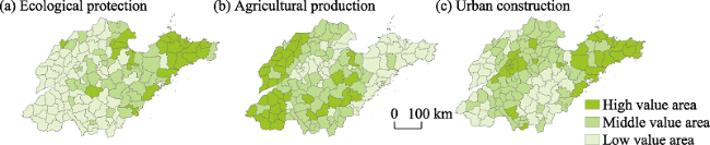
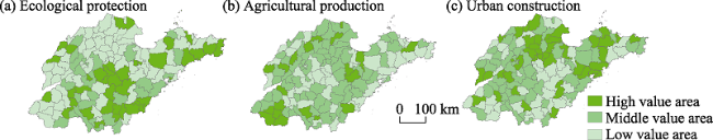
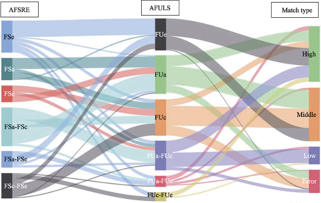
Based on the carrying capacity of the resources and the environment, this article defines the connotation of the land multifunctional space (LMFS) from three aspects, ecological protection, agricultural production and urban construction, in the new era of land space planning system. Moreover, a framework is constructed for the coordinated development of the multi-functional oriented space to match the use of land space (ULS) with the supply of resources and environment (SRE). Based on this, the technology and methods of comprehensive evaluation, dominance recognition, and matching relationship division functions of the use of land space (FULS) and functions of the supply of resources and environment (FSRE) are discussed. The advantageous functions of the use of land space (AFULS) and advantageous functions of the supply of resources and environment (AFSRE) are also identified in the study area. A LMFS coordinated development system integrating “function position-comprehensive partition-regulation strategy” is proposed. Through the empirical study of Shandong province, we found that, first, the FULS of ecological protection space in the province is mainly found in high value areas, and the FSRE is mainly in low value areas, which has certain complementarity in the space. The FULS of agricultural production space is mainly observed in high value areas, the FSRE is mainly in middle value areas, and the spatial distribution is balanced and staggered. The FULS of the urban construction space and the FSRE are mainly in middle values areas, and the spatial distribution is basically similar. Second, the FULS in the study area is dominated by the single advantage of agricultural production and urban construction, while the FSRE has a relatively balanced distribution of the advantages of ecological protection, single agricultural production and compound advantages of agricultural production and urban construction, and urban construction and ecological protection. The matching between the two is mainly at high and middle levels. Specifically, 70% of the province’s land space still has a certain development and utilization potential, and 30% of ULS intensity is close to or exceeds the resource and environment carrying capacity. Third, considering the comprehensive impact of resource endowment, social and economic development and policy and institutional environment on different matching relationships, this paper constructs the land spatial development strategic pattern of “two screens-seven regions-multicore” positioning and “four regions-eight categories” hierarchical area of Shandong at the macro level, and puts forward a differentiated land space development strategy.

Cite this article

QU Yanbo , ZHANG Yanjun , WANG Shilei , SHANG Ran , ZONG Haining , ZHAN Lingyun . Coordinated development of land multi-function space: An analytical framework for matching the supply of resources and environment with the use of land space for ecological protection, agricultural production and urban construction[J]. Journal of Geographical Sciences, 2023 , 33(2) : 311 -339 . DOI: 10.1007/s11442-023-2084-z

1 Introduction

Land space is a complex system formed by natural and human elements. In addition to one main function, a certain land space can have multiple other functions (Wei et al., 2017; Fan and Zhou, 2021). With the rapid advancement of China’s urbanization and industrialization, China’s spatial structure and pattern have undergone drastic changes. Problems such as the continuous expansion of the scale of the construction land, the continuous reduction of the cultivated land area, and the destruction of the ecological environment have intensified with economic development (Ma et al., 2020). The key to the sustainable utilization of land space, as well as an important topic in the study of land space problems, is the coordinated development of ecological protection, agricultural production, and urban construction.
Under the multiple directions of ecological protection, agricultural production and urban construction, exploring the optimal spatial organization scheme under the framework of coordinated development is the core of land spatial planning. It is also the result of the long-term interaction between human production activities and resource endowment. The resulting land spatial layout and support system has become a topic of interest for all sectors of society (Chen et al., 2018; Sun et al., 2019). At present, the existing research is mainly focused on the connotation of land space function (Xie et al., 2020; Li et al., 2021), evaluation of the land space function (Verburg et al., 2009; Zhou et al., 2017; Ulasi et al., 2020), optimization and regulation of the land space structure (Warnken and Mosadeghi, 2018; Hansen et al., 2019; Li et al., 2019; Liu et al., 2019), and environmental response and sustainability of the land space utilization (Wende et al., 2010; Chen et al., 2020). In particular, the connotation of land space function focuses on the analysis and introduction of the background function of resources and environment, reveals the regional resource endowment, and provides a basis for the further development and use of land space (Martire et al., 2015; Zhang et al., 2020). Land space function evaluation focuses on the research and analysis of the functional state of land space use, reveals the rationality of land space use, and lays a foundation for the formulation of land space development, utilization and protection policies (Shi et al., 2018). Land space structure has been optimized through the value cognition and the space demand analysis of the multi-scale planning subjects (Hauck et al., 2013; Beery et al., 2016), and a land space allocation plan that meets the needs of human activities was put forward. Sustainable utilization of land space is the solution to the problems of insufficient resource supply, and insufficient ecological protection during the process of industrialization and urbanization. The solution to these problems comes through the optimization of the land space pattern in developed countries and regions (Meriem and Ewa, 2014; Kirchner et al., 2015; Rome, 2015). The fruitful results obtained have important reference value for the research of this paper, but most of these studies have actively discussed FULS and FSRE from a single perspective. The research on the correlation between FULS and FSRE is relatively weak. In recent years, China has taken the lead in the process of implementation of the construction of ecological civilization, taking ecological protection as the background constraint for the development and utilization of land resources. In addition, it has attempted to realize the coordinated development of FULS and FSRE of ecological protection, agricultural production and urban construction in land space planning at all levels in the new era. Therefore, in the face of the conflict between socio-economic development and ecological protection, an effective matching between development and ULS by human activities and SRE is an important prerequisite for the coordinated development of multi-functional land space.
In accordance with the content system of land spatial planning in the new era (Qu et al., 2017), and under the guidance of the matching type between the ULS and SRE, this paper constructs a logical framework for the coordinated development of LMFS from three different dimensions: ecological protection, agricultural production and urban construction. This paper takes 137 county-level administrative units located in Shandong province as the research objects. The FULS and the FSRE in the county area are comprehensively evaluated, and are revealed through the superiority discrimination and feature analysis. The functional match type and the formation mechanism between the multifunctional space of the country, the mismatch and low allocation of the use and supply of the multi-functional land space of the country, and the coordinated development of the multifunctional space of the country from the aspects of functional positioning, comprehensive zoning and control strategies, represents the new era of land space development. Theoretical support is provided in the form of preparation of land space planning.

2 Research framework

Coordinated development refers to the coordination of two or more resource types or individuals who, through optimized configuration or mutual cooperation, strive to achieve a common goal, or the so called “win-win effect” of common development (Coenen et al., 2012). Land space is the space in which human activities occur, and is composed of a series of different types of functional units. In the new era of the land space planning system, ecological protection, agricultural production and urban construction are the main types of LMFS (Wang and Fan, 2019; Luo et al., 2020). The coordinated development of LMFS refers to the process of coordinating the matching relationship between the ULS and the SRE, and realizing the harmonious coexistence between human activities and ecological environment, through the optimal allocation of ecological protection, agricultural production and urban construction space. In essence, it is a process of improving the ULS based on the supply capacity of regional resources and the environment. Therefore, this paper constructs the research framework of coordinated development of the LMFS from four aspects: connotation, characteristics, process and strategy (Figure 1).
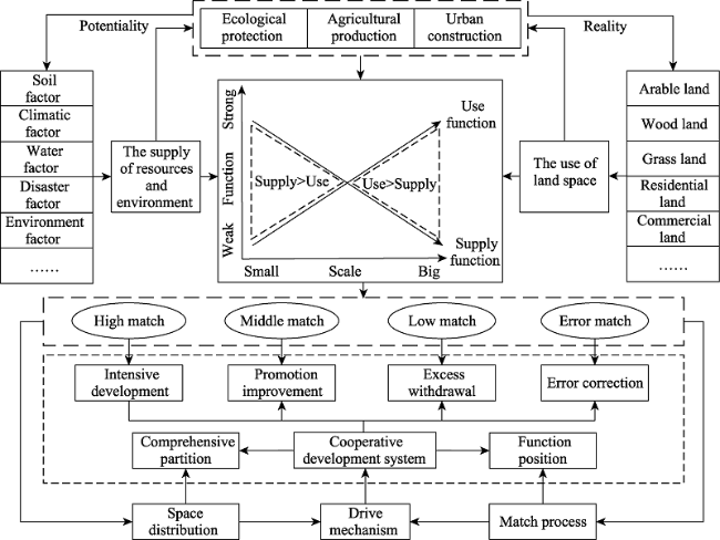
Figure 1 Research framework of the coordinated development of the LMFS
First, the LMFS possesses different specific connotations. Among them, the functional space of ecological protection mainly provides ecological products and services to mankind. It is responsible for the formation of ecosystems and ecological processes and the natural conditions for human survival, and is the basic constraint for the development and utilization of land space. The implementation of ecological protection activities can improve the regional ecological environment and enhance economic development. The main goal of the functional space of agricultural production is to provide humans with biomass and non-biomass products, and services, which generally refers to grain production, livestock breeding, and vegetable and fruit planting in rural areas. Agricultural production is the basic function of the development and utilization of land space. Through the optimization and protection of agricultural production space, the output of grain and other agricultural products can be improved and the ability to support the population can be enhanced. The functional space of the urban construction focuses on providing high-quality life and production services for mankind, by processes such as promoting population and industrial agglomeration, public service facilities construction, and cultural construction. Urban construction is an important function of the development and urbanization of land space. Through the moderate increase and intensive utilization of urban construction space, the requirements of livability and industry can be met, and the capacity of urbanization development can be enhanced.
Second, the LMFS is provided and constrained by the resource and environmental background conditions of a certain area, and has the characteristics of reality and potential. Among them, the reality is reflected in the intensity of human needs and activities. The use of overseas LMFS is expressed through the actual structural organization of cultivated land, forest, and garden lands, towns, villages, transportation and water conservancy facilities, water areas and other types of lands with different purposes. The potential is reflected in the carrying capacity under the endowment of regional resources and environment. The FSRE to the LMFS is formed through the comprehensive action of regional climate, soil, hydrology, environment, disasters and other factors. The reality and potential of the LMFS are interrelated and integrated. The FSRE is the background condition of the FULS. Analyzing the gap between FSRE and FULS can objectively reflect whether the development and utilization of land space exceeds the bearing range of the resources and the environment.
Moreover, a certain comparative relationship and corresponding matching process exist between the FULS and FSRE of LMFS. When the scale and intensity of the LMFS, which is provided by resources and environment, are greater than or equal to the actual use of land space, it is shown that the endowment conditions of resources and environment can support human activities and development needs. This in turn shows that the FULS and FSRE of the LMFS are highly or moderately matched, and that the LMFS is in a relatively coordinated state. On the contrary, there is a mismatch or low matching between the FULS and FSRE of LMFS, and the LMFS is in a relatively uncoordinated state. At the same time, for different regions, the matching process between the FULS and FSRE of the LMFS is different, with certain spatial heterogeneity. The result of this performance is driven by natural and human factors.
Finally, under the influence of different driving factors, different matching types of land space need to be optimized and regulated through different degrees and methods, in order to build a support system for the coordinated development of the LMFS. From the perspective of the logic of the relationship between use and supply, the support system include three aspects: functional positioning, comprehensive partitioning and control strategies. Among these aspects, the purpose of the functional positioning is to clarify the dominant or advantageous functions of the regional land space. Since the use intensity of the LMFS depends on the SRE capacity, according to the principle of the bottom-line constraint, the functional orientation of land space should be determined based on the advantageous functions of the resource and environment supply. Comprehensive zoning is a supplement to the dominant or advantageous functions. It is usually based on the use and supply relationship of the LMFS in a region, and its function is to divide the first-level and second-level areas of the comprehensive functions of the land space. The first-level area focuses on policy guidance, and the second-level area emphasizes space control. Subsequently, it is necessary to formulate regulation and control strategies, which matches with the comprehensive zoning of the land space. Combined with the compound characteristics of the development and the protection with functional positioning of the land space, the regulations and control policies of the LMFS can be gradually transited from the role of development to the role of protection. Then, they can reflect the policy guidance of “key protection”, “general protection”, “key development” and “general development” for the first-level area. The second-level area is broken down according to the matching type. The category with a high match shall remain stable, the development of the category with a middle match can be expanded, and the category with a low match shall gradually withdraw from the space for over-exploitation and utilization. Finally, the mismatching category shall correct the wrong orientation in the development and utilization of land space and strengthen the background protection of the ecological environment.

3 Research methods

3.1 Evaluation of land space use function

The FULS focuses on expressing the relevant situation of the intensity of regional human activities, mainly by taking the socio-economic factors as the evaluation elements, and forming the functional score through the synthesis of various factors. First, the appropriate indicators are selected from the following three aspects, ecological protection, agricultural production and urban construction, and the index weight is determined by combining the entropy weight method and the analytic hierarchy process. Then, by considering the difficulty of obtaining each index, and taking the county-level administrative region as the basic unit, the scores of the FULS for ecological protection, agricultural production and urban construction are calculated.

3.1.1 Index evaluation system

Many influencing factors of the FULS are derived from human activities. Drawing on the results of the existing functional evaluation system (Jin et al., 2020; Qu et al., 2021), and combining the actual development of cities in Shandong province, a multi-functional evaluation index system for the city is constructed. Among them, six indicators are selected for the ecological protection function: FUe1-FUe2 represent the greening level and reflect the ecological conservation ability, and FUe3-FUe6 represent the environmental energy status, and reflect the level of pollution control. Five indicators are selected for the agricultural production function: FUa1-FUa5 represent the basis of the agricultural production, and reflect the strength of the research unit in the agricultural production. Six indicators are selected for the urban construction function: FUc1-FUc2 represent the living conditions and people’s living comfort, and FUc3-FUc6 represent the public service capacity and the security level of people’s living (Table 1).
Table 1 Evaluation index system and the use function of the weight of land space
Type Index Calculation method Explanation Weight
Ecological protection function
(FUe)
Park green area per capita (FUe1) Total area of park green space/Total population + 0.05832
Green space ratio (FUe2) Green space area/Total land area + 0.07764
Clean energy efficiency (FUe3) Clean energy consumption/Total households + 0.06499
Perfection of environmental
protection facilities (FUe4)
Treatment rate of domestic waste, sewage and solid waste + 0.06375
Non-point source pollution ratio (FUe5) Concentration of non-point source pollutants/Total households - 0.06189
Three waste treatment ratios (FUe6) Number of households with three wastes centralized processing/Total households + 0.07823
Agricultural production function
(FUa)
Collective economic income per unit land (FUa1) Collective economic income/Land area + 0.06922
Production land area per capita (FUa2) Total area of production land/Total population + 0.05547
Proportion of labor force (FUa3) Population aged 18-60/Population + 0.04495
GDP per unit land (FUa4) GDP/Land area of administrative area + 0.04548
Proportion of agricultural land area (FUa5) Land area of agricultural industry/ Total land area + 0.04523
Urban
construction function
(FUc)
Proportion of land area for
housing (FUc1)
Building area/Total land area - 0.04875
Housing area per capita (FUc2) Residential floor area/Population + 0.06285
Public service land area ratio (FUc3) Land area for water, electricity and other infrastructure and public
service facilities such as administration, medical treatment, culture and education/Total land area
+ 005574
Traffic convenience (FUc4) Traffic land area/Total land area + 0.06634
Perfection of public service
facilities (FUc5)
Proportion of public service
facilities
+ 0.05283
Proportion of land area for
secondary and tertiary industries (FUc6)
Land area of secondary and tertiary industry/Land area of administrative area + 0.04832

3.1.2 Calculation of the functions of the use of land space score

According to the trend of the positive and negative effects of each index, the original data are standardized by the extreme value change method, and normalized to a dimensionless index for comparison. Then, the FULS score is calculated as follows:
$F{{{U}'}_{ij}}=\sum\nolimits_{i=1}^{n}{w{{u}_{ij}}\times f{{u}_{ij}}}$
where fuij represents the original score of the j indicator of the i function type, wuij represents the index weight of the factor j of the ith function type, and$F{{{U}'}_{ij}}$is the comprehensive score of functions used. According to the calculation results, the natural discontinuity method is used to classify FULS into three levels: low, medium and high.

3.2 Evaluation of the functions of the supply of resources and environment

The FSRE focuses on the expression of regional natural resources and environmental endowment. It mainly takes natural factors as evaluation elements, and considers the differences in the manifestations of various natural factors. First, the uniform standard grid data (50 m × 50 m) is taken as the basic evaluation unit, and then the restrictive factor evaluation method is used to calculate the supply function of different types of resources and environment. In order to effectively compare and analyze the FULS, the grid scores of the supply functions are converted to calculate the FSRE scores of different administrative units.

3.2.1 Evaluation index system

Land space is a bearing platform that people can utilize to develop the functions of ecological protection, agricultural production and urban construction. The development stages and processes of the land space are diverse, changeable and comprehensive (Liu, 2019). In the context of “multi compliance and integration”, the evaluation of the function of the supply of resource and environment is guided by resource endowment. Through field investigation and relevant literature review (Klein et al., 2013; Zhou et al., 2019), the indexes are selected based on the principles of scientificity, systematicness, rationality and data availability. The FSRE evaluation indexes are evaluated from three aspects: ecological protection functions, agricultural production functions, and urban construction functions (Tables 2-4).
Table 2 Evaluation index system of the importance of the function of the ecological protection
Target layer Factor layer Divisor layer Calculation formula
Ecological protection function
(FSe)
Ecosystem service
function
Biodiversity maintenance FSe1 $E{{s}_{1}}=NP{{P}_{mean}}\times {{F}_{pre}}\times {{F}_{temp}}\times (1-{{F}_{ait}})$
Water conservation FSe2 $E{{s}_{2}}=NP{{P}_{mean}}\times {{F}_{sic}}\times {{F}_{pre}}\times (1-{{F}_{slp}})$
Water and soil conservation FSe3 $E{{s}_{3}}=NP{{P}_{mean}}\times (1-K)\times (1-{{F}_{slp}})$
Wind prevention and sand fixation FSe4 $E{{s}_{4}}=NP{{P}_{mean}}\times K\times {{F}_{q}}\times D$
Ecological
sensitivity
Water and soil loss sensitivity FSe5 $E{{s}_{5}}=\sqrt[4]{R\times K\times LS\times C}$
Desertification sensitivity FSe6 $E{{s}_{6}}=\sqrt[4]{I\times W\times K\times C}$

Note: In the formula, NPPmean is the net primary productivity of vegetation, Fpre is the amount of the annual precipitation, Ftemp is the annual average temperature, Fait is the altitude factor, Fsic is the soil seepage factor, Fslp is the slope factor, K is the soil erodibility factor, Fq is the annual average climate erosivity, D is the surface roughness factor, R is the rainfall erosivity factor, LS is the topographic relief factor, I is the dryness index, and W is the number of windy and sandy days greater than 6 m/s in winter and spring. The normalized threshold of each factor is (0, 1).

Table 3 Evaluation index system and the weight of the function of the agricultural production suitability
Target layer Element layer Factor layer Factor grading assignment Weight
0 1 3 5 7
Agricultural production function
(FSa)
Land factor Slope/° (FSa1) ≥25 15-25 6-15 2-6 <2 0.13
Silt content/% (FSa2) ≥80 60-80 40-60 20-40 <20 0.10
Water factor Precipitation/mm (FSa3) <200 200-400 400-800 800-1200 ≥1200 0.14
Total water
resources/10,000 (FSa4)
<3 3-8 8-13 13-25 ≥25 0.12
Climate factor Light-heat
conditions (FSa5)
<1500 1500-4000 4000-5800 5800-7600 ≥7600 0.13
Environment factor Soil environmental
capacity (FSa6)
More than 150% risk control value 100%-150% of risk
control value
Risk screening value 70% -100% Greater than the risk screening value but less than or equal to 70% of the risk control
value
Less than or equal to the risk screening value 0.12
Disaster factor Frequency of meteorological disasters/%
(FSa7)
>80 60-80 40-60 20-40 ≤20 0.12
Ecology factor Salinization sensitivity (FSa8) 1.0-3.0 3.1-5.0 5.1-6.0 6.1-7.0 >7.0 0.14

Note: The soil environmental capacity classification standard is based on the “Soil Environmental Quality Agricultural Land Soil Pollution Risk Control Standard (Trial)” (GB 15618-2018). For the classification standard of salinization sensitivity, refer to the “Guidelines for Delineation of Ecological Protection Red Lines (Trial)”.

Table 4 Evaluation index system and the weight of the function of the urban construction suitability
Target layer Element layer Factor layer Factor grading assignment Weight
0 1 3 5 7
Urban construction
function
(FSc)
Land factor Slope/° (FSc1) >25 15-25 8-15 3-8 ≤3 0.17
Elevation/m (FSc2) >50 30-50 20-30 10-20 ≤10 0.13
Water
factor
Total water resources/(m3/km2) (FSc3) <5 Ten thousand 5-10 Ten
thousand
10-20 Ten thousand 20-50 Ten
thousand
≥50 Ten thousand 0.17
Climate factor Comfort (FSc4) <32 or >90 32-41 or 82-90 41-51 or 73-82 51-60 or 65-73 60-65 0.12
Environment factor Atmospheric environmental capacity index (FSc5) ≤0.2 0.2-0.4 0.4-0.6 0.6-0.8 >0.8 0.09
Water environmental capacity/(t/km2) (FSc6) <0.04 0.04-0.14 0.14-0.39 0.39-0.96 ≥0.96 0.10
<0.8 0.8-2.9 2.9-7.8 7.8-19.2 ≥19.6
Disaster factor Distance from broken belt/m (FSc7) <30 30-100 100-200 200-400 >400 0.08
Peak ground acceleration/g (FSc8) ≥0.30 0.20 0.15 0.10 ≤0.05 0.07
Cumulative land subsidence/mm (FSc9) >2400 1600-2400 800-1600 200-800 <200 0.06

Note: Comfort is characterized by the temperature humidity index, THI=T-0.55×(1-f) ×(T-58), where THI is the temperature humidity index, T is the monthly average temperature (expressed in the Fahrenheit scale), and f is the monthly average relative humidity. COD and NH3-N are used as control factors for the capacity of the water environment.

3.2.2 Calculation method of functions of the supply of resources and environmental score based on grid

Due to the differences between the LMFS types and evaluation factor attributes, different data quantification and hierarchical assignment methods are needed. In order to divide the calculation results of each factor into 3 levels using the natural break point method, the importance level of the function of the ecological protection uses the step-by-step correction method. The highest levels of biodiversity maintenance, water conservation, water and soil conservation, wind prevention and sand fixation, water and soil loss sensitivity and desertification sensitivity are taken. As a result, the importance level of ecological protection is divided into three levels: extremely important, important and generally important.
$FSe=\text{max}(E{{s}_{1}},E{{s}_{2}},E{{s}_{3}},E{{s}_{4}},E{{s}_{5}},E{{s}_{6}})$
The evaluation of the suitability of the functions of the agricultural production and urban construction is calculated using the factor assignment-restrictive comprehensive evaluation method (Equation 5). Specifically, the complexity of the selected indicators and the effectiveness of factor weights are comprehensively considered, the weights of each index system are determined through the entropy weight method and the analytic hierarchy process, and the corresponding specifications are used to assign the factors hierarchically as follows:
$F{{S}_{ij}}=\left\{ \begin{matrix} 0, \ (f{{s}_{ij}}=0) \\ \sum\nolimits_{i=1}^{n}{w{{s}_{ij}}\times f{{s}_{ij}}~},(f{{s}_{ij}}\ne 0) \\\end{matrix} \right.~$
where FSij is the ith function type (when$~i$=1, FS1 is the score of the function of the agricultural production; When i=2, FS2 is the score of the function of the urban construction), wsij represents the index weight of factor j of the ith function type, fsij represents the index score of factor j of the ith function type. When FSi=0, it is unsuitable; when FSi≠0, it is divided into general suitable and suitable according to the natural break point method.

3.2.3 Calculation method of functions of the supply of resources and environmental score based on administrative unit

The functions of the ecological protection, agricultural production and urban construction in the evaluation data of the FSRE are classified as appropriate (extremely important), generally appropriate (important) and inappropriate (generally important). Since the conversion from the grid unit to the administrative unit involves the normalization of different types of functions, the center of gravity method is adopted here. The appropriate (extremely important) generally suitable (important) and unsuitable (important) are assigned as 3, 1 and 0 respectively, multiplied by different independent grid areas, and the scores of the supply functions of different administrative units are calculated as follows:
$F{{{S}'}_{ij}}=(3{{r}_{ij1}}+1{{r}_{ij2}}+0{{r}_{ij3}})/3$
where$F{{{S}'}_{ij}}$ is the score of different function types, and rij1, rij2 and rij3 represent different types of functions, which are classified as appropriate (extremely important), generally appropriate (important) and inappropriate (generally important). According to the calculation results, the natural discontinuity method is used to divide the FSRE into three levels: low, middle and high.

3.3 Advantageous function discrimination of the use of land space and the supply of resources and environment

The advantageous functions of each county-level administrative region, including the AFSRE and the AFULS, are calculated on the basis of standardization and quantification. The location quotient formula is used to measure the superiority of each research unit function (Zhang et al., 2014). If there are m research units (j) in the research area, and each research unit has n functions (i), the calculation formula is as follows:
${{I}_{i}}=\frac{{{{{F}'}}_{ij}}}{\mathop{\sum }_{i=1}^{n}{{{{F}'}}_{ij}}}~$
${{P}_{i}}=\frac{\mathop{\sum }_{j=1}^{m}{{{{F}'}}_{ij}}}{\mathop{\sum }_{j=1}^{m}\mathop{\sum }_{i=1}^{n}{{{{F}'}}_{ij}}}$
${{\beta }_{i}}=\frac{{{I}_{i}}}{{{P}_{i}}}$
where${{{F}'}_{ij}}$ is the i function of the research unit j, Ii is the share of i function of the j research unit in all functions of the research unit, Pi is the share of the i functions of all research units in all functions of all research units, βi is the location entropy of the i function of the j research unit. If βi = 1, the i function of j research unit has reached the average level of all regions, if βi < 1 the average level has not been reached, and if βi > 1 the average level has been exceeded and has a significant comparative advantage.

3.4 Classification of the matching types of the advantageous function between functions of the use of land space and functions of the supply of resources and environment

The matching types of the advantageous function signify that the advantage of the LMFS is consistent with the advantage of the resource and environmental supply. According to the principle of ecological priority, based on the identification of the above advantageous functions, the matching types between the AFSRE and the AFULS are divided by using the triangular model (He et al., 2020). The three axes of the triangle represent the functions of the ecological protection, agricultural production and urban construction (Figure 2).
Figure 2 The matching model diagram
The high matching type refers to the situation where the AFSRE matches the AFULS completely, which indicates that the current situation of land space development has reached an ideal level. Moreover, the ecological protection function in the AFULS is also an advantageous function, and thus the situation is classified as the high matching type.
The middle matching type refers to situation where there are two AFSREs, but only one AFULS. Another FSRE has not yet reached the ideal utilization level and has great potential for improvement. On the premise of maintaining the stability of advantageous functions, the focus should be on the development of the weak functions.
The low matching type refers to the situation where there is only one AFSRE, but there are two AFULSs. The AFULS of the region has exceeded the carrying capacity of the local resource endowment, and its development direction must be coordinated.
The error matching type refers to the situation where the AFSRE is inconsistent with the AFULS, and, as a result, the development is misplaced. The AFULS needs to be adjusted in accordance with the resource endowment, and its development direction must be adjusted.

3.5 Construction of the land multifunctional space coordinated development system based on the type of matching between the functions of the use of land space and the functions of the supply of resources and environment

According to the research framework design and the characteristics of the abovementioned matching types of the advantageous function, a LMFS coordinated development system is constructed from three aspects: function position of the land space, comprehensive partition of the land space, and regulation strategy of the land space (Figure 3).
Figure 3 LMFS collaborative development system matching the ULS and the SRE
First, based on the background conditions of the resources and the environment, the elements of regional land resources, water resources, climate, environment, disasters and ecology are integrated, and the positioning of the regional land spatial functions from the perspective of the main functions is clarified. Specifically, a regional development strategic pattern is formed from three aspects, key ecological functions, main agricultural products and urbanization development. Then, in accordance with the principle of both the development and protection of the land space, and in combination with the matching relationship between the FULS and the FSRE, a two-level national land space comprehensive zone is constructed. The first-level area focuses on policy guidance and control degree of the protection and development. The second-level area refines the development and protection of the ULS areas and its matching relationship with the background of the SRE, and focuses on resolving the problems existing in the process of the development and protection of land space. Finally, combined with the matching relationship between the ULS and the SRE in different regions, aiming at the occurrence process and the influencing factors of the high, middle, low and error matching, different control strategies are put forward from the aspects of intensive, promotion, rational and improved development.

3.6 Overview of the study area and data sources

Shandong province is located on the east coast of China and covers a total area of 157,100 square kilometers. The landform is dominated by mountains and hills, with plains and basins staggered throughout. The province has a jurisdiction of 16 prefecture-level cities, 137 county-level administrative regions and 64,000 administrative villages, with a total population of 120 million and an urbanization rate of 61.18%. It has a warm temperate monsoon climate, and the annual precipitation is generally 550-950 mm. The total GDP of the province is 7346.97 billion yuan, the per capita disposable income of rural residents is 16,297 yuan, and the overall level of economic development is good. However, with the acceleration of urbanization and the adjustment of the consumption structure, the FULS of some regions has exceeded the existing resource carrying capacity of the region. There are prominent contradictions between food security and the hidden reduction of cultivated land resources. Moreover, urbanization is rapidly advancing, and the upgrade of the urban transformation is marked. As the current environmental pollution and the low ecological carrying capacity of supply have become more prominent, the negative effects of economic development are becoming increasingly obvious. Therefore, selecting Shandong as the research area has strong significance for the research and analysis of the matching relationship between the AFULS and the AFSRE.
This paper takes 137 county-level administrative regions in Shandong province as the research objects. The data of ecological protection function of resource and environment supply are taken from China Meteorological Data Service Centre (China Meteorological Data Service Centre), Big Data Center of Sciences in Cold and Arid Regions (Big Data Center of Sciences in Cold and Arid Regions), Harmonized World Soil Database V1.2, Basic Science Data Sharing Network (Basic Science Data Sharing Network), Geospatial Data Cloud (Geospatial Data Cloud), etc. The data of agricultural production function and urban construction function are mainly obtained from Shandong Provincial Department of Natural Resources, Shandong Meteorological Bureau, Shandong Geological Survey Institute, National Meteorological Information Center, Shandong Provincial Department of Water Resources, Shandong Provincial Seismological Bureau, China Land Survey and Planning Institute, Shandong Provincial Geographic Information Center and other departments concerned. The socio-economic data required for the evaluation of land space use function are taken from “Shandong Statistical Yearbook, 2020”, GDP spatial data (1 km×1 km) are from the Resource and Environment Science Data Center, population data (100 m×100 m) are from Asian Population Data (Asian Population Data), and the administrative divisions of Shandong province data come from the National Basic Geographic Information Center (Basic Geographic Information Center). Finally, all kinds of land spatial function index data are matched and linked to form the basic database of land space function research in Shandong province (Figure 4).
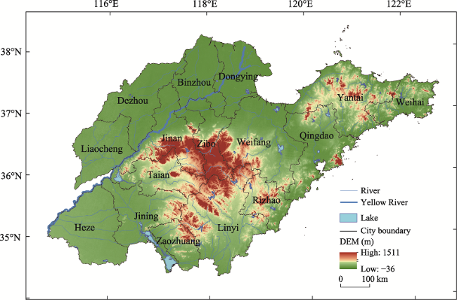
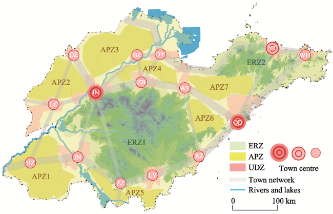
Figure 4 Location of Shandong province

4 Result analysis

4.1 Status of the use of land space and the supply of resources and environment

It can be seen from Figure 5 that the FULS of Shandong province is distributed in blocks within the spatial range, and that the scores of the functions of the ecological protection, which are distributed in clusters, are between 0.1876-0.8893. Among them, the high value areas include 25 county-level administrative regions, which are distributed in patches in eastern Shandong and a small amount distributed in northern Shandong. The middle areas
Figure 5 Distribution of the FULS in Shandong province
include 35 county-level administrative regions, which are mainly adjacent to high value areas. The low value areas include 77 county-level administrative regions, mainly distributed in the southwest, north and west Shandong. The score of the function of the agricultural production is between 0.2215-0.9219, showing a transitional distribution state of “high in the west and low in the east”. The high value areas include 36 county-level administrative regions, which are mainly distributed in west, southwest and northwest Shandong. The middle areas include 53 county-level administrative regions, mainly distributed in southern, central and northern Shandong. Low value areas include 48 county-level administrative regions, mainly distributed in central and northern Shandong, and the Shandong Peninsula. The urban construction function score is between 0.1987-0.8863, showing a distribution pattern of “high on both sides and low in the middle”. The high value areas include 34 county-level administrative regions, which are widely distributed in central and eastern Shandong. The middle value areas include 61 county-level administrative regions, which are irregularly distributed around the high value areas. Low value areas include 42 county-level administrative regions, mainly distributed in central, southern and southwestern Shandong.
It can be seen from Figure 6 that the spatial distribution of the various FSRE in Shandong province is obviously different. The score of the function of the ecological protection is between 0.1781-0.8346, with high and low value areas distributed in patches, and the middle areas being scattered. The high value areas include 38 county-level administrative regions, which are mainly found in patches in southern Shandong. The middle value areas include 29 county-level administrative regions, which are mainly around high value areas. The low value areas include 70 county-level administrative regions, mainly in southwest, north and east Shandong. The score of agricultural production function ranges from 0.1326-0.8876. The high value areas are scattered, while the middle and low value areas are adjacent. The high value areas include 19 county-level administrative regions, mainly in southwest Shandong, with a small number of counties. The middle value areas include 73 county-level administrative regions, which are distributed throughout the province, with a large number of counties. The low value areas include 45 county-level administrative regions, mainly in eastern and central Shandong. The urban construction function score is between 0.1483-0.9122, with obvious spatial heterogeneity. The high value areas include 44 county-level administrative regions, mainly distributed in Qingdao and Jinan. The middle value areas include 53 county-level administrative regions, which are mainly in blocks around the high value areas. Low value areas include 40 county-level administrative regions, mainly distributed in central, southern and southwestern Shandong.
Figure 6 Distribution of the FSRE in Shandong province

4.2 Advantageous function identification of functions of the supply of resources and environment and functions of the use of land space

As can be seen from the overall analysis of the study area, the AFULS and the AFSRE have spatial differences. The distribution of the AFSRE is relatively uniform, and the number of the single advantageous functions is not much different from the number of the composite advantageous functions. The opposite trend is observed for AFULS, as the number of single advantageous functions is different from the number of composite advantageous functions. It can be concluded that human activities have a great impact on the distribution and development of the AFULS (Figure 7).
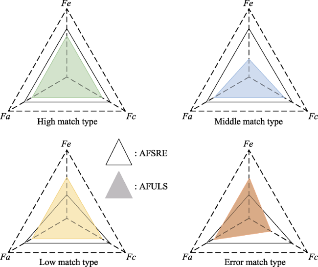
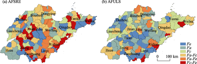
Figure 7 Quantity distribution of the AFSRE and the AFULS in Shandong province
From the perspective of the single dominant function type, there are 25 county-level administrative regions whose AFSRE is ecological protection, and there are 29 county-level administrative regions whose AFULS is ecological protection. The supply function exceeds expectations, indicating that some county-level administrative regions still pay more attention to the protection of the ecological environment in the process of economic development. There are 24 county-level administrative regions whose AFSRE is agricultural production, and there are 34 county-level administrative regions whose AFULS is agricultural production, indicating that some counties have overdeveloped their function of agricultural production. There are 15 county-level administrative regions whose AFSRE is urban construction, and there are 33 county-level administrative regions that have urban construction as their AFULS, indicating that the abovementioned problems also exist and need to be improved.
From the perspective of the compound advantageous function types, there are 35 county-level administrative regions whose AFSRE is agricultural production-urban construction, and there are only 27 county-level administrative regions whose AFULS is agricultural production-urban construction. In 15 and 23 county-level administrative regions, the AFSRE is agricultural production-ecological protection and urban construction-ecological protection, respectively. In only 9 and 5 county-level administrative regions, AFULS is agricultural production-ecological protection and urban construction-ecological protection, respectively, which indicates that not all counties have the same coordinated development of advantageous functions. Targeted measures need to be taken so as to promote the coordinated development of various functions.

4.3 The matching relationship between the use of land space and the supply of resources and environment

4.3.1 Matching type

The matching relationship between the FSRE and the FULS refers to the matching relationship between different research units, which is achieved by calculating and comparing the differences between the AFULS and the AFSRE, based on various development factors. These factors include ecological environment conditions, agricultural production conditions and urban construction conditions of each county-level administrative region (Figure 8).
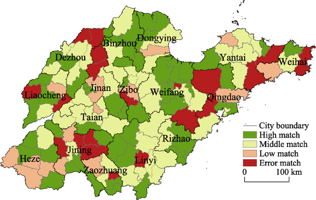
Figure 8 Function matching types of the FSRE and the FULS in Shandong province
It can be seen from Figure 8 that the FSRE is highly matched with the FULS in 51 county-level administrative regions, accounting for 37.23% of the total number of study areas. These areas are widely distributed in the middle of the eastern areas, as well as in the north of the central areas, with limited endowment of resources and environment, and low impact of human activities on the environment. Among them, there is both continuous “block” distribution and sporadic “point” distribution. Point areas are distributed throughout the province, indicating that there is no strong correlation between the matching of the AFSRE and the AFULS and the region. The middle matching relationship includes 49 county-level administrative regions, accounting for 35.77% of the total number of study regions, showing a “band-like” distribution. They are distributed in central and western Shandong, and a few are located in Jiaodong. The low matching relationship includes 16 county-level administrative regions, accounting for 11.68% of the total number of study regions, showing a “point-like” distribution. These regions are distributed in southwestern and central Shandong and Shandong. The error matching relationship includes 21 county-level administrative regions, accounting for 15.33% of the total study areas, which are distributed in northwest, southwest Shandong and Shandong Peninsula in the form of a “triangle”.

4.3.2 Matching process

According to the matching type of the AFSRE and the AFULS, combined with the research area, this paper analyzes the matching process of the AFSRE and the AFULS. As can be seen from Figure 9, AFSRE and AFULS are not in a one-to-one correspondence. There are 25, 24 and 15 county-level administrative regions with advantageous functions of ecological protection, agricultural production and urban construction in the SRE respectively, but there are only 15, 10 and 6 county-level administrative regions with AFULS in these regions. The advantageous functions of the remaining county-level administrative regions are not the corresponding types of the advantageous functions. In the SRE, there are 35, 15 and 23 county-level administrative regions with advantageous functions of agricultural production and urban construction, agricultural production and ecological protection, and urban construction and ecological protection, respectively. However, there are only 11, 4 and 4 county-level administrative regions with AFULS in these regions, and the advantageous functions of the remaining county-level administrative regions are not the corresponding types of the advantageous functions. There are 29, 34 and 33 county-level administrative regions whose AFULS are ecological protection, agricultural production and urban construction, respectively, most of which belong to the high or middle matching relationship. There are no county-level administrative regions with the low matching relationship, and only a few belong to county-level administrative regions with error matching relationship. There are 27, 9 and 5 county-level administrative regions whose AFULS are agricultural production and urban construction, agricultural production and ecological protection, and urban construction and ecological protection, respectively. Most of them belong to the high and low matching relationship, and the rest belong to the middle and error matching relationship.
Figure 9 Matching process of AFSRE and AFULS

4.3.3 Matching mechanism

The dominant relationship function, whose study areas are distributed in the plain area, is the highly matched relationship. The temperature in this area is suitable, the precipitation is abundant, the economy is relatively developed, and the urbanization level is relatively high. The benefit of the agricultural production and urban construction is high, and it has a significant positive effect on the supply and demand of the functions of the agricultural production and urban construction, while it has a small effect on those of the central mountains and hills. This is mainly because the ecological environment is better in mountainous areas, and counties in the region have established development priority zones, which restricts the development of agricultural production and town’s protection functions. The AFSRE and the AFULS of this study area are ecological protection, which has a positive effect, and an inhibitory effect on the matches of other functions (Figure 10).
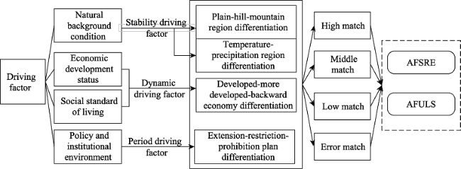
Figure 10 Matching driving mechanism between the AFSRE and the AFULS
The dominant relationship function, whose study areas are mostly distributed in economically developed areas, is the middle matching relationship. The geographical location and topographic conditions of the areas are also suitable for the development of the functions of the agricultural production and ecological protection, but the focus of economic development process is on the function of the urban construction. As a result, the level of urbanization is relatively high, and national policies tend to give priority to the development of cities and the concentrated development of agriculture. The AFSRE and the AFULS positively promote the functions of agricultural production and urban construction. In contrast, the effect is negative for areas where AFSRE is ecological protection function.
The dominant relationship function, whose study areas are concentrated in the southwest of Shandong, is the low matching relationship. These areas are located in the plain with little rainfall and a relatively arid climate, which are most suitable for the development of the function of the agricultural production. However, in the process of economic development, the urban construction function is excessive. The development and utilization of the function of the urban construction exceed the resource endowment of the function of the local resources and environmental supply. Therefore, the excessive development of the function of the urban construction is the main factor leading to the over-allocation of the FULS.
Research areas with mismatch relationship functions are distributed throughout the province. The AFSRE in this region is inconsistent with the AFULS. Areas that are located in plains with convenient transportation, are more suitable for the development of the function of the agriculture production. However, in the process of economic development, more emphasis is placed on the development of the function of the urban construction, so that the urban construction is an advantageous function. The planning of the main functional area also divides some areas into priority urban development areas. Therefore, areas where the AFSRE is not urban construction are the main factors leading to the mismatch. For mountainous and hilly areas, AFSRE is ecological protection. However, in the actual development process, the advantageous functions of agricultural production and urban construction occupying a dominant position are a major factor in the mismatch between the AFSRE and the AFULS.
The driving factors of the various functions of land space in Shandong are the comprehensive embodiment of multiple factors and effects of natural background conditions, economic development, people’s living standards and policy and institutional environment. They promote and influence each other, and promote regional differences in the functions of the ecological protection, agricultural production and urban construction, from different directions and different degrees of action. First, the natural conditions have the most initial and direct impact on the SRE and the dominant function matching of the ULS, and are also the basis for the differentiation between plains, hills and mountains, and temperature and precipitation. Since natural conditions are inherently stable and also have a long-term effect on land space, they are classified as stable drivers. By affecting the ecological environment and natural resource endowment conditions of the research unit, natural background conditions have a sustainable strengthening effect on the FSRE. Second, the level of economic development and people’s living conditions are the key factors for the differentiation of the match relationship between the AFSRE and the AFULS, and they are also the leading factors for the multi-gradient differentiation of developed, underdeveloped, and backward regions. Since these factors change with the form of the regional economic development, they are classified as dynamic driving factors. In different periods, the difference between the AFULS and the AFSRE creates a phased optimization effect. Third, the institutional and policy environment is a profound factor affecting the functional matching between the AFSRE and the AFULS, especially the planning of the main functional areas of land space in recent years, which plays an important role in the functional matching of the AFSRE and the AFULS. Nevertheless, institutional policies often have certain pertinence and timeliness. When the advantageous function matching tends to be stable in a certain period of time, the effectiveness of the relevant systems and policies will be weakened, which is classified as a cycle driving factor in this paper. The abovementioned different driving factors play different roles in the matching relationship of the high, middle, low and error matching types, which makes the spatial differentiation of the AFSRE and the AFULS of the research unit significant.

4.4 The land multifunctional space collaborative development system based on the matching of the functions of the use of land space and the supply of resources and environment

4.4.1 Development positioning and strategic layout of the land multifunctional space

Based on the natural conditions of the study area and the existing development foundation, a “two screens-seven areas-multicore” national LMFS development strategy is constructed at the macro level. The dominant function for the development is the utilization and protection of regional land space. “Seven areas” refers to the agricultural production pattern dominated by seven continuous farmland areas in southwest Shandong, Northwest Shandong, North Shandong, Zibo-Weifang, Linyi-Zaozhuang, Jiaozhou-Laizhou and Southeast Shandong. The study area has a commercial grain production base with a large agricultural land area and good conditions for development. Its goal is to strengthen the construction of the modern agriculture production and characteristic economic zone, and stabilize and improve the supply capacity of agricultural products. “Multicore” refers to the establishment of a network-level urbanization development pattern, with Jinan and Qingdao as the core, and prefecture-level cities as the sub-center. This is a study area with a good foundation for social and economic development, and a large population and strong production capacity. The development goal is to enhance not only the power of innovation and development but the ability to radiate and drive, and promote the formation of a high-quality development system with global industry complementarity and efficient collaborations (Figure 11).
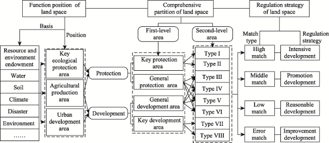
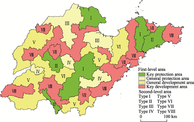
Figure 11 Strategic pattern of LMFS development in Shandong province

Note: ERZ means key ecological functional areas. APZ means agricultural production areas. UDZ means urban development areas.

4.4.2 Comprehensive partition of the land multifunctional space

On the basis of summarizing the FSRE and the FULS of Shandong province, the first-level comprehensive functional area is divided by the notions of knowledge and experience, and the second-level area is divided on the basis of the first-level area. According to the connotation of land space comprehensive functional area (Fan, 2015; Jin et al., 2020), the land space type characteristics and dominant advantageous functions of the research area are clearly expressed (Figure 12).
Figure 12 Comprehensive functional area of land space in Shandong province
Key protected areas include 21 county-level administrative regions, accounting for 15.33% of the total number of regions in the province. The dominant function of these regions is mainly ecological protection. In terms of the distribution of secondary areas, the I type areas include 14 county-level administrative regions, accounting for 10.22% of the province’s total. They are mainly distributed in the hills of central Shandong, low mountains and hills in eastern Shandong, and by the estuary of the Yellow River. They are important areas for ecosystem services, as well as ecologically fragile areas in the province. They ensure the ecological security, maintain ecosystem service functions, maintain and improve the supply capacity of ecological products, and promote the construction of ecological civilization demonstration areas. The areas of Type II include 7 county-level administrative regions, accounting for 5.11% of the total number of the province. They are mainly distributed around the areas of Type I, and their ecological importance is second only to the areas of Type I. They are the main region promoting the ecological construction and management and protection of forests, carrying out water and soil conservation control in small watersheds, and implementing ecological restoration, road reconstruction and land remediation.
The general protected areas include 20 county-level administrative regions, accounting for 14.6% of the total number of the province. Their dominant functions are mainly ecological protection and agricultural production. On the one hand, these areas are still important ecologically protected areas, but their importance is lower than that of areas I and II. The areas focusing on the function of the ecological protection correspond to the class III county-level administrative regions. On the other hand, agricultural production activities can be properly carried out in these areas, corresponding to class IV county-level administrative regions. The areas of Type III include 14 county-level administrative regions, accounting for 10.22% of the total number of the province. They are mainly distributed in the Yellow River Delta. They are also the main areas of Shandong which have implemented ecological restoration, control the southward movement of saline alkali line and provide wetland functions for the province. The areas of Type IV include 6 county-level administrative regions, accounting for 4.38% of the total number of the province. Scattered in central Shandong and southwest Shandong and other areas, these areas are the main parts for the agricultural production activities, on the basis of providing ecological products and services.
The general development areas include 38 county-level administrative regions, accounting for 27.74% of the total number of the province. Their dominant functions are mainly agricultural production and urban construction. On the one hand, the region has a large area of cultivated land and good agricultural development conditions, and it also ensures food security and the supply of important agricultural products corresponding to the areas of Type V. On the other hand, in the process of agricultural production, the development of urban construction function in some areas is also relatively good, which are classified as the areas of Type VI. The areas of Type V include 28 county-level administrative regions, accounting for 20.44% of the total number of the province. They are mainly distributed in southern Shandong, southwest Shandong, northwest Shandong and Jiaolai. These areas are key areas that promote the centralized and continuous development of cultivated land, advance the appropriate scale development of agriculture, and promote the construction of modern agriculture. The areas of Type VI include 10 county-level administrative regions, accounting for 7.3% of the province’s total. They are mainly distributed in western Shandong and the Shandong Peninsula. These areas are the demonstration zones for agricultural product processing, ecological industry and county-level characteristic economy, and as well as for the rural revitalization in Shandong.
The key development areas include 58 county-level administrative regions, accounting for 42.34% of the province’s total, and their advantageous functions are mainly urban construction. The areas of Type VII include 18 county-level administrative regions, accounting for 13.14% of the total of the province, which are mainly distributed in Jinan, Qingdao, Yantai, Linyi and other metropolitan areas. This region has a good foundation for economic and social development, a strong concentration of population and industrial capacity, and it is the main power source of the promotion of the high-quality development of the province. The areas of Type VIII include 40 county-level administrative regions, accounting for 29.2% of the total of the province. They are mainly distributed around the areas of Type VII, but are also scattered in the southwest and northwest of the province. The economic development of this region is second only to the category I areas. They are the second most important areas for gathering population and industrial capacity, and important support areas for the promotion of the coordinated development of all the regions in the province.

4.4.3 Regulation strategies of the land multifunctional space

Land space comprehensive partition entails the promotion of the utilization of the LMFS, in order to achieve the expected goal, and the refining of the appropriate land space regulation strategies based on the spatial functions. Therefore, on the basis of second-level areas, the focus is on the main advantageous functions of the region, combined with the matching of the AFSRE and the AFULS in Shandong. The focus is also on the comprehensive promotion of the coordinated development of the functions of the ecological protection, agricultural production and urban construction, in accordance with the guiding principles of ecological priority, being people-oriented and the guiding ideology of the land space development. Therefore, according to the characteristics of different matching types, different land space regulation strategies are adopted.
The high matching relationship type implements the strategies based on intensive development. For example, the AFSRE in Pingdu City of Qingdao City and Mudan District of Heze City are agricultural production and urban construction, and the AFULS are also agricultural production and urban construction. The development status and resource endowment potential of these research units are in a high matching relationship, and the improvement space is not obvious. Therefore, there is no need to carry out large-scale land space optimization activities, and the existing advantageous functions can be improved and optimized on the original basis. However, it is necessary to further summarize the existing typical development experiences and models of the county-level administrative regions, explore intensive and efficient development paths, and reasonably plan future development paths based on the continuous development of the AFULS. At the same time, it is necessary to focus on the protection of the ecological environment, tap the potential of the ecological environment in depth, and improve the strength of the FSRE.
The middle matching relationship type implements the strategy of promoting development. The FSRE in this type has an advantageous function, but the FULS does not reflect the advantageous function, while maintaining the development level. Thus, close attention should be paid to the high potential elements, the advantages and disadvantages of development should be clarified, and the focus of regional development should be determined. The regulation strategies are divided into the following three types. The first type is the ecological protection function enhancement strategy. For example, the AFSRE in Huancui District of Weifang City, Lingcheng District of Dezhou City and other areas are urban construction and ecological protection, while the AFULS is urban construction. This is designed in view of the resource endowment of ecological protection in the place. The basic principle of “ecology priority, resource conservation” needs to be upheld, and close attention needs to be paid to the relationship between economic development and ecological protection in order to promote the coordinated development of regional industry, economy, and ecology. In the same manner as regional economy, ecological protection should be taken as the guarantee link of future sustainable development, the ecological environment in the area needs to be fully protected, and further damage to the ecological environment should be avoided. The second type is the agricultural production function promotion strategy. For example, the AFSRE in Cangshan County of Linyi City, Decheng District of Dezhou City and other areas are agricultural production and ecological protection, while the AFULS is ecological protection. According to the resource endowment of agricultural production, the spatial layout of agricultural production needs to be adjusted and optimized, the comprehensive quality of agricultural land needs to be improved, the construction of farmland water conservancy facilities needs to be strengthened, and the farming methods and irrigation modes need to be improved. The third type is the urban construction function enhancement strategy. For example, the AFSRE in Gaotang County of Liaocheng City, Gaomi City of Weifang City and other regions are agricultural production and urban construction, while the AFULS is agricultural production. This is based on the resource endowment of the urban construction of the region. It aims at the advantageous function of urban construction in the resource and environmental supply function, and clarifies the basic form of the urban layout. With this strategy, the urban scale structure is more complete, green production and green consumption become the mainstream of urban construction functions, infrastructure and public service facilities are more complete, and the urban development embodies individualization, humanization and intelligence. It is necessary to focus on the urban construction activities that cannot break through the boundaries of urban development and protect the local ecological environment.
The low matching relationship type implements the strategy focused on the rational development. In this type of matching relationship, the FULS has an advantageous function, while the FSRE does not have advantageous function, which shows that the FULS has exceeded the resource endowment carrying capacity of the place. Under the guidance of the land space planning blueprint, the strength of FULS needs to be reduced and exit strategies for over-exploited advantageous functions need to be implemented. The regulation strategies are divided into the following two types. The first type is the exit strategy of the function of the agricultural production. For example, the AFSRE in Dongying District of Dongying City, Jimo District of Qingdao City and other areas is urban construction, while the AFULS is agricultural production and urban construction, which is regulated based on the endowment of local agricultural production resources. This mainly includes the current agricultural production space without carrying capacity and low suitability, such as the areas where the slope is more than 25°, areas where the ecological importance is very high, and areas where the farmland needs to be returned to forest and grassland. The second type is the exit strategy of the function of the urban construction. For example, the AFSRE in Chengwu County of Heze City, Chiping County of Liaocheng City and other areas is agricultural production, while the AFULS is agricultural production and urban construction. Regulation is based on the resource endowment of local urban construction to optimize the structure and layout of regional energy consumption. And more attention should be paid to the protection of ecologically fragile areas by establishing a sound system for monitoring and supervising the discharge of pollutants. In promoting urbanization, the expansion of urban construction land scale should be reasonably controlled, the negative impact of too fast urban expansion should be avoided, the level and efficiency of intensive utilization of construction land need to be improved, and the three-dimensional development of urban construction space needs to be promoted.
The mismatch relationship type implements the advantageous function improvement strategy. In view of the mismatch between the AFULS and the AFSRE of the comprehensive zoning, the intensity of the FULS must be reduced in accordance with the local resource endowment and the requirements of protecting the ecological environment, in order to adjust the development direction of the advantageous function in time. The regulation strategies are divided into the following two types. The first type is the improvement strategy of the function of the agricultural production. For example, the AFSRE in Jiaxiang County of Jining City, Jiaozhou City of Qingdao City and other areas is urban construction, while the AFULS is agricultural production. This gives priority to the development of the function of the ecological protection in accordance with the actual situation. If the endowment allows it, the timely development of the urban construction function should adjust the urban spatial layout and improve the traffic network structure as the main means to meet the needs of the corresponding urban development stage. The production factors in the area need to be reasonably allocated, the development level of towns and villages in the area needs to be improved by optimizing the utilization of resources, ecological protection needs to be taken as the guarantee link in the process of future sustainable development, and the ecological environment in the area needs to be fully protected. The second type is the improvement strategy of the function of the urban construction. For example, the AFSRE in Rushan City of Weihai City, Junan County of Linyi City and other areas is ecological protection, while the AFULS is urban construction. This gives priority to the development of ecological protection function according to local conditions, and timely develops the function of the agricultural production, under the condition of resource endowment. Appropriate use of the ecological landscape in the area should be made in order to drive the development of the regional characteristic industries, and the appropriate scale operation of ecological agriculture needs to be promoted, so as to realize the ecological linkage between the regional environment and the economic output. On the other hand, the treatment of agricultural non-point source pollution should be straightened, the construction of farmland shelterbelt needs to be appropriately enhanced, and the regional ecological environment needs to be optimized.

5 Discussion and conclusions

5.1 Discussion

The functions of the land space have obvious scale characteristics, and the results of the identifying function types in different spatial scales in the same region may be different. The traditional zoning method is building an evaluation index system for each evaluation unit in the region at the index layer, and then conducting calculations and analysis for the whole region. This method is not conducive to the multi-topic integration and multi-scale integration from the functional space (Jin et al., 2017). Therefore, in order to address the problem that traditional zoning methods are not conducive to multiple integrations from functional space, each evaluation unit should reflect the various functions of the land space, and the dominant function should be used to quantify the strength of the various functions, based on which to develop. Then, this form of spatial function transfer on scale will effectively solve the problem of the multi-theme integration and multi-scale integration in land spatial zoning, and provide theoretical support for the positioning of the function of land spatial in the study area (Pittman and Armitage, 2016; O’Hagan et al., 2020; Fan and Guo, 2021).
In the research method, the FSRE is compared with the FULS, and a triangular model of the relationship between natural conditions and current usage characteristics is constructed to distinguish the matching types of different functional spaces. When FSRE>FULS, the land space is in high and middle matching states. When FSRE<FULS, the land space is in a low degree of matching state. When FSRE≠FULS, the land space is in a state of mismatch. This method can intuitively depict the resource endowment conditions, actual use status and related characteristics of the research object, and propose the corresponding adjustment strategies. For example, in highly matched areas such as Pingyi County and Ningyang County, the AFULS is compatible with the AFSRE. This indicates that the development potential should be deeply tapped and an intensive and efficient development path should be explored. In the moderately matched areas such as Licang District and Lixia District, one aspect of the FULS has not reached the ideal level of the FSRE. Such areas should be targeted to improve the weak functions, the development experience should be summarized, and the existing advantageous elements should be used to drive the regional development. In low matching areas such as Longkou City and Jinxiang County, the development intensity of FULS has exceeded the carrying capacity of FSRE. Here, the development factors should be reasonably allocated and resource utilization methods should be optimized. In mismatched areas such as Lanshan District and Ningjin County, the AFULS is inconsistent with the AFSRE. Hence, the development direction should be adjusted to improve the level of sustainable development.
This paper constructs a new pattern of land space development and protection, which reveals the proportion relationship of functional space among agricultural production, urban construction and ecological protection. An organic whole is formed in the land space structure of the study area, facilitating the development of spatial zoning research (Liu and Fang, 2014; Deng et al., 2015). Comparing the development strategy pattern of national LMFS with the Territorial Spatial Planning of Shandong Province (2021-2035), the two are basically consistent in the main production areas of agricultural products and urban development areas, while the key ecological functional areas are slightly different in the coastal areas of northeast Shandong. This also indicates that this paper comprehensively considers the limitations of the existing research on the functions of land space from a single perspective. The revealed function matching mechanism and driving factors of AFSRE and AFULS are helpful to enrich and improve the existing relevant land space theory, and provide a theoretical basis for guiding the preparation of land space planning in the new era.
This paper constructs the research framework of coordinated development of the LMFS from four aspects: connotation, characteristics, process and strategy. This not only has reference significance for the next step of “double evaluation” at the county level, but also has extensive popularization value for the study of land space in different regions. There are still some deficiencies. First, restricted by basic data and research scale, this study only conducts a static study on the comparison between the AFSRE and the AFULS. It lacks the analysis from the perspective of a long-term series, and the constructed index system also has room for further improvement. Second, the research framework of multi-functional coordinated development of land still needs to be improved. The research on the matching between the FSRE and FULS is still in the development stage. The research framework of this paper should not only be analyzed from the perspective of geography, but should also be combined with sociology and politics to further expand the field of scientific research.

5.2 Conclusions

This paper analyzes the matching relationship between the advantageous functions from the perspective of the FSRE and the FULS, and then determines the suitability of land space development, utilization and protection to the development of the functions of ecological protection, agricultural production and urban construction. This can help to reasonably determine the scale and structural layout of the land space development and utilization in the future. Identifying the matching relationship between the AFSRE and the AFULS, and making targeted adjustment strategies are essential for the promotion of the coordinated development of the ecological civilization construction and the land multi-function in Shandong province. The main conclusions can be drawn as follows:
(1) From the three dimensions of ecological protection, agricultural production and urban construction function, this study found that the high, medium and low values of the FULS of Shandong have significant spatial aggregation. From west to east, the ecological protection function forms a “progressive” spatial pattern of area agglomeration with low value in the west, medium value in the middle and high value in the east. The agricultural production function presents a spatial distribution pattern opposite to the ecological protection function. The low value area, medium value area and high value area of urban construction function are distributed in a “circle type” spatial pattern. The FSRE has the characteristics of spatial heterogeneity. The spatial distribution of ecological protection, agricultural production and urban construction functions presents a “mosaic” spatial pattern, where the high value areas are embedded in middle value areas and low value areas.
(2) There are significant differences in the quantitative distribution of AFSRE and AFULS in the province. Specifically, in terms of single dominant functions, the number of dominant functions of ecological protection, agricultural production and urban construction in the AFSRE is 25, 24 and 15, respectively, and the number of dominant functions in the AFULS is 29, 34 and 33, respectively. In terms of compound advantageous functions, the number of agricultural production-urban construction, agricultural production-ecological protection and urban construction-ecological protection functions in the AFSRE is 35, 15 and 23, respectively, and the number of AFULS is 27, 9 and 5, respectively. The improvement of compound advantageous function is the focus of future development. Differentiated collaborative development measures should be taken according to the morphological characteristics and existing problems of different research units.
(3) According to the matching relationship of the three dimensions of the functions of the ecological protection, agricultural production and urban construction, the matching types can be divided into the high, middle, low, and error matching types. The high matching type shows “block” distribution in the eastern and central regions, and “point” distribution in the western region. The middle matching type shows the characteristics of “zonal” distribution in the central region and “point” distribution in Jiaodong region. The low matching type shows “block” distribution in the southwest and “point” distribution in the whole province. The mismatching type is “triangular” in northwest, southwest, and Jiaodong. Through the above research, it can be concluded that the matching of the AFULS with the AFSRE is not closely related to the region, and that factors such as humanity, history and economic development play a more important role.
[1]
Beery T, Stålhammar S, Jönsson K I et al., 2016. Perceptions of the ecosystem services concept: Opportunities and challenges in the Swedish municipal context. Ecosystem Services, 17(2): 123-130.

DOI

[2]
Chen M X, Liang L W, Wang Z B et al., 2018. Geographical thoughts on the relationship between ‘Beautiful China’ and land spatial planning. Journal of Geographical Sciences, 30(5): 705-723.

DOI

[3]
Chen M X, Liu W D, Lu D D et al., 2018. Progress of China’s new-type urbanization construction since 2014: A preliminary assessment. Cities, 78: 180-193.

DOI

[4]
Coenen L, Benneworth P, Truffer B, 2012. Toward a spatial perspective on sustainability transitions. Research Policy, 41(6): 968-979.

DOI

[5]
Deng X Z, Huang J K, Rozelle S et al., 2015. Impact of urbanization on cultivated land changes in China. Land Use Policy, 45: 1-7.

DOI

[6]
Fan J, 2015. Draft of major function oriented zoning of China. Acta Geographica Sinica, 70(2): 186-201. (in Chinese)

DOI

[7]
Fan J, Guo R, 2021. Scientific Foundations and Strategies of National Territorial Spatial Governance during the 14th Five-Year-Plan Period in China. Urban Planning Forum, 263(3): 15-20. (in Chinese)

[8]
Fan J, Zhou K, 2021. Theoretical thinking and approach exploration on deepening the implementation of major function zoning strategy with “Three-zones and Three-lines”. China Land Science, 35(9): 1-9. (in Chinese)

[9]
Hansen R, Olafsson A S, Rall E et al., 2019. Planning multifunctional green infrastructure for compact cities: What is the state of practice? Ecological Indicators, 96(2): 99-110.

[10]
Hauck J, Görg C, Varjopuro R et al., 2013. Benefits and limitations of the ecosystem services concept in environmental policy and decision making: Some stakeholder perspectives. Environmental Science & Policy, 25: 13-21.

[11]
He J, Jin X B, Liang X Y et al., 2020. Research of rural system development potential in Huaihai Economic Zone: A case study of Northern Jiangsu province under the background of urban-rural integration. Journal of Natural Resources, 35(8): 1940-1957. (in Chinese)

DOI

[12]
Jin G, Deng X Z, Dong Y et al., 2020. China’s multidimensional poverty measurement and its spatiotemporal interaction characteristics in the perspective of development geography. Acta Geographica Sinica, 75(8): 1633-1646. (in Chinese)

[13]
Jin G, Deng X Z, Zhang Q et al., 2017. Comprehensive function zoning of national land space for Wuhan metropolitan region. Geographical Research, 36(3): 541-552. (in Chinese)

DOI

[14]
Jin G, Shi X, He D W et al., 2020. Designing a spatial pattern to rebalance the orientation of development and protection in Wuhan. Journal of Geographical Sciences, 30(4): 569-582.

DOI

[15]
Kirchner M, Schmidt J, Kindermann G et al., 2015. Ecosystem services and economic development in Austrian agricultural landscapes-the impact of policy and climate change scenarios on tradeoffs and synergies. Ecological Economics, 109: 161-174.

DOI

[16]
Klein T, Holzk Mper A, Calanca P et al., 2013. Adapting agricultural land management to climate change: a regional multi-objective optimization approach. Landscape Ecology, 28(10): 2029-2047.

DOI

[17]
Li J Z, Xiao O Y, Zhu X et al., 2021. Land space simulation of urban agglomerations from the perspective of the symbiosis of urban development and ecological protection: A case study of Changsha-Zhuzhou-Xiangtan urban agglomeration. Ecological Indicators, 126: 107669.

DOI

[18]
Li X, Fang B, Yin R M et al., 2019. Spatial-temporal change and collaboration/trade-off relationship of “production-living-ecological” functions in county area of Jiangsu province. Journal of Natural Resources, 34(11): 2363-2377. (in Chinese)

DOI

[19]
Liu J, Jin X B, Xu W Y et al., 2019. Spatial coupling differentiation and development zoning trade-off of land space utilization efficiency in eastern China. Land Use Policy, 85: 310-327.

DOI

[20]
Liu Y S, 2019. Research on the geography of rural revitalization in the new era. Geographical Research, 38(3): 461-466. (in Chinese)

DOI

[21]
Liu Y S, Fang F, Li Y, 2014. Key issues of land use in China and implications for policy making. Land Use Policy, 40: 6-12.

DOI

[22]
Luo W L, Wang Y Y, Zhang H, 2020. A novel method of division major function oriented zoning using multi-source data in Guangzhou, China. Tropical Geography, 40(1): 110-118. (in Chinese)

DOI

[23]
Ma L, Long H L, Tu S H et al., 2020. Farmland transition in China and its policy implications. Land Use Policy, 92: 104470.

DOI

[24]
Martire S, Castellani V, Sala S, 2015. Carrying capacity assessment of forest resources: Enhancing environmental sustainability in energy production at local scale. Resources, Conservation and Recycling, 94: 11-20.

DOI

[25]
Meriem N A A, Ewa B A, 2014. Algiers carrying capacity with respect to per capita domestic water use. Sustainable Cities and Society, 13: 1-11.

DOI

[26]
O’Hagan A M, Paterson S, Tissier M L, 2020. Addressing the tangled web of governance mechanisms for land-sea interactions: Assessing implementation challenges across scales. Marine Policy, 112: 103715.

DOI

[27]
Pittman J, Armitage D, 2016. Governance across the land-sea interface: A systematic review. Environmental Science & Policy, 64(10): 9-17.

[28]
Qu Y B, Jiang G H, Yang Y T et al., 2018. Multi-scale analysis on spatial morphology differentiation and formation mechanism of rural residential land: A case study in Shandong province, China. Habitat International, 71: 135-146.

DOI

[29]
Qu Y B, Jiang G H, Zhao Q L et al., 2017. Geographic identification, spatial differentiation, and formation mechanism of multifunction of rural settlements: A case study of 804 typical villages in Shandong province, China. Journal of Cleaner Production, 166(10): 1202-1215.

DOI

[30]
Qu Y B, Zhan L Y, Jiang G H et al., 2021. How to address “Population Decline and Land Expansion (PDLE)” of rural residential areas in the process of urbanization: A comparative regional analysis of human-land interaction in Shandong province. Habitat International, 117: 102441.

DOI

[31]
Rome A, 2015. The limits to growth: A report for the club of Rome’s project on the predicament of mankind. Nature, 527(7579): 443-445.

[32]
Shi Z Q, Deng W, Zhang S Y et al., 2018. Spatio-temporal pattern changes of land space in Hengduan Mountains during 1990-2015. Journal of Geographical Sciences, 28(4): 529-542.

DOI

[33]
Sun Y X, Liu S L, Dong Y H et al., 2019. Spatio-temporal evolution scenarios and the coupling analysis of ecosystem services with land use change in China. Science of the Total Environment, 681: 211-225.

DOI

[34]
Ulasi J O, Uwadiegwu B O, Okoye C O, 2020. Assessment of the Level of Compliance of Petroleum Filling Stations to Development Control Standards on Land Space/Size and Setbacks in Anambra State. Civil and Environmental Research, 12(2): 77-87.

[35]
Verburg P H, Steeg J V D, Veldkamp A et al., 2009. From land cover change to land function dynamics: A major challenge to improve land characterization. Journal of Environmental Management, 90(3): 1327-1335.

DOI PMID

[36]
Wang Y F, Fan J, 2019. The core-periphery structure of major function zones in China. Acta Geographica Sinica, 74(4): 710-722. (in Chinese)

DOI

[37]
Warnken J, Mosadeghi R, 2018. Challenges of implementing integrated coastal zone management into local planning policies: A case study of Queensland, Australia. Marine Policy, 91: 75-84.

DOI

[38]
Wei H J, Fan W G, Wang X C et al., 2017. Integrating supply and social demand in ecosystem services assessment: A review. Ecosystem Services, 25: 15-27.

DOI

[39]
Wende W, Huelsmann W, Marty M et al., 2010. Climate protection and compact urban structures in spatial planning and local construction plans in Germany. Land Use Policy, 27(3): 864-868.

DOI

[40]
Xie X T, Li X S, He W K, 2020. A land space development zoning method based on resource-environmental carrying capacity: A case study of Henan, China. International Journal of Environmental Research and Public Health, 17(3): 900.

DOI

[41]
Zhang B L, Zhang F R, Gao Y et al., 2014. Identification and spatial differentiation of rural settlements’ multifunction. Transactions of the CSAE, 30(12): 216-224. (in Chinese)

[42]
Zhang H B, Li M H, Zhang Q L, 2020. Construction of land classification system and land type identification for territorial spatial planning based on multi-source data. Transactions of the Chinese Society of Agricultural Engineering, 36(5): 261-269. (in Chinese)

[43]
Zhou D, Xu J C, Lin Z L, 2017. Conflict or coordination? Assessing land use multi-functionalization using production-livingecology analysis. Science of the Total Environment, 577(1): 136-147.

DOI

[44]
Zhou X Y, Zheng B H, Khu S T, 2019. Validation of the hypothesis on carrying capacity limits using the water environment carrying capacity. Science of the Total Environment, 665: 774-784.

DOI

Outlines

/