
Journal of Geographical Sciences >
Morphological evolution of the channel-shoal system in the South Channel of the Changjiang Estuary during 1958-2018: Causes and future trends
|
Luan Hualong, PhD and Senior Engineer, specialized in river evolution and management. E-mail: luanhualong@126.com |
Received date: 2021-11-11
Accepted date: 2022-06-02
Online published: 2022-11-25
Supported by
Natural Science Foundation of China-Ministry of Water Resources-China Three Gorges Corporation Joint Fund for Changjiang Water Science Research(U2040202)
National Natural Science Foundation of China(42006156)
National Natural Science Foundation of China(52009008)
Fundamental Research Funds for Central Public Welfare Research Institutes(CKSF2021530/HL)
Research Project on Major Scientific and Technological Issues in Watershed Water Management(CKSC2020791/HL)
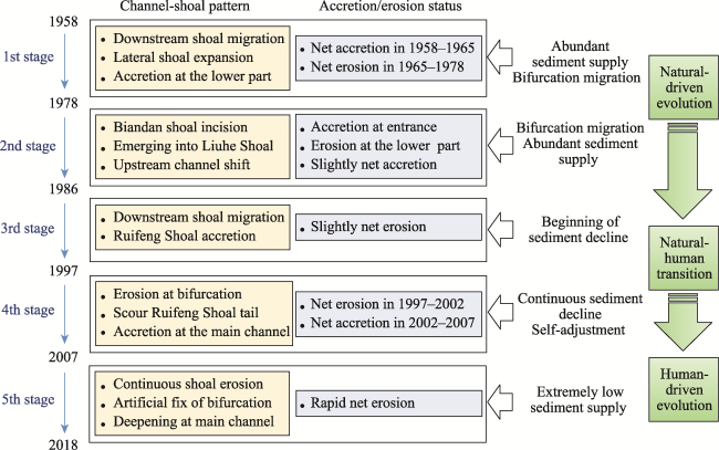
The stability of estuarine channel-shoal systems is important for port utilization, navigation maintenance, habitat protection and ecosystem service functions. This paper uses the South Channel of the Changjiang (Yangtze River) Estuary as a typical example to investigate the channel-shoal adjustment mechanism and its future trend. The combined approaches of bathymetric data analysis and process-based modeling (Delft3D) are applied. Quantitative analysis of morphological changes indicates that the South Channel experienced remarkable channel-shoal adjustment during 1958-2018. Periodic evolution was identified, including shoal migration, incision and emergence under natural conditions before the mid-1980s. Since then, fluvial sediment decline and local human intervention have interrupted the periodic processes. After 1986, as river sediment discharge started to decline, the South Channel converted to net erosion, and both the mid-channel shoal at the bifurcation node and the tail of the Ruifeng Shoal showed significant scour. Process-based hydrodynamic simulations revealed that the northern rotation of the mainstream downstream of Wusong triggered the erosion of the Ruifeng Shoal, while unordered sand mining at the shoal tail in approximately 2002 enhanced shoal shrinkage. In addition, the self-adjustment of the transverse section shape resulted in abnormal accretion in 2002-2007. Afterward, the South Channel underwent overall erosion as sediment discharge decreased to a low level (<150 Mt/a). Five stages of channel-shoal pattern adjustment and accretion/erosion status during the past 60 years were defined, i.e., the accretion stage (1958-1965), remarkable channel-shoal adjustment stage (1978-1986), slow erosion stage (1986-1997), shoal scour and shrinkage stage (1997-2007) and overall channel-shoal erosion stage (2007-2018). Model prediction of the evolutionary trend indicates that overall erosion within the South Channel is most likely to continue in 2015-2050. Further adjustment of the South Channel under extremely low sediment discharge may threaten the riverbed stability and the sustainable development of this large-scale estuary. Future work on adaptive strategies for varying conditions is recommended.
LUAN Hualong , YAO Shiming , QU Geng , LEI Wentao . Morphological evolution of the channel-shoal system in the South Channel of the Changjiang Estuary during 1958-2018: Causes and future trends[J]. Journal of Geographical Sciences, 2022 , 32(11) : 2291 -2310 . DOI: 10.1007/s11442-022-2048-8
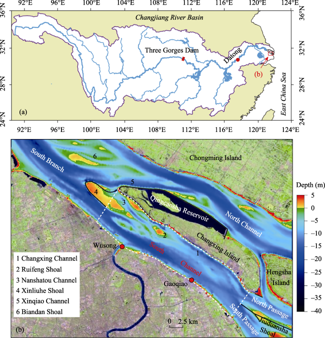
Figure 1 Map of the study area (a. Locations of the South Channel (red rectangle) and Changjiang River Basin (white area); b. South Channel with bathymetry observed in 2018; white dashed lines denote the domain for the morphological calculation of the South Channel.) |
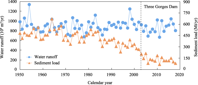
Figure 2 Variations in annual river runoff and sediment load at the Datong station (tidal limit) since 1950 |
Table 1 Information on the bathymetric dataset used in this study |
| No. | Year | Scale | Source | Survey month |
|---|---|---|---|---|
| 1 | 1958 | 1:100,000 | NGDCNH | 8-0 |
| 2 | 1965 | 1:100,000 | SWB | 4-1 |
| 3 | 1973 | 1:50,000 | SWB | 3-1 |
| 4 | 1978 | 1:120,000 | NGDCNH | - |
| 5 | 1986 | 1:50,000 | SWB | 5-9 |
| 6 | 1994 | 1:120,000 | NGDCNH | - |
| 7 | 1997 | 1:50,000 | YEWAB | 12 |
| 8 | 2002 | 1:25,000 | YEWAB | 12 |
| 9 | 2007 | 1:50,000 | YEWAB | 8 |
| 10 | 2010 | 1:10,000 | YEWAB | 8 |
| 11 | 2013 | 1:10,000 | YEWAB | 8 |
| 12 | 2018 | 1:10,000 | YEWAB | 2 |
Note: NGDCNH: Navigation Guarantee Department of the Chinese Navy Headquarters; SWB: Shanghai Waterway Bureau, Ministry of Transport of China; YEWAB: Yangtze Estuary Waterway Administration Bureau, Ministry of Transport of China |
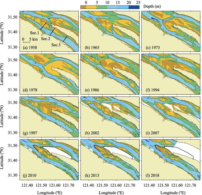
Figure 3 Observed bathymetry of the South Channel from 1958 to 2018 |
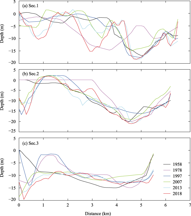
Figure 4 Variations in three typical sections in the South Channel from 1958 to 2018 (see Figure 3a for the locations) |
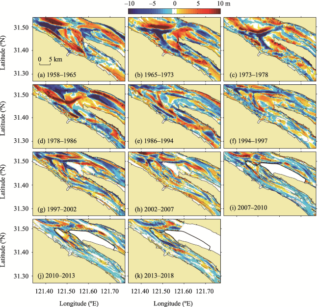
Figure 5 Erosional and depositional patterns of the South Channel in different periods from 1958 to 2018 |
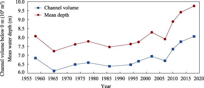
Figure 6 Variations in mean water depth and channel volumes along the South Channel (see the domain in Figure 1b) |
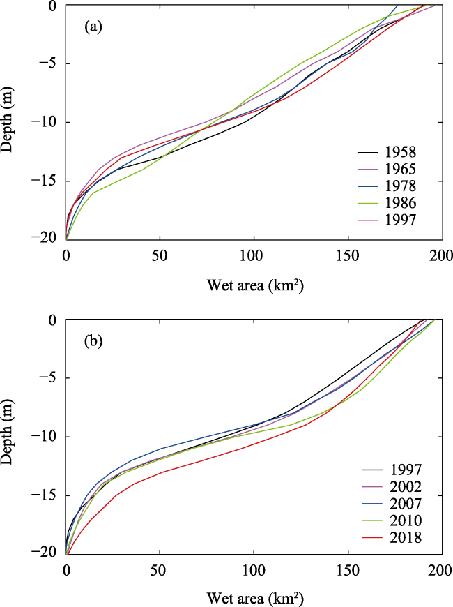
Figure 7 Hypsometry curves of the South Channel from 1958 to 2018 (see the domain in Figure 1b) |
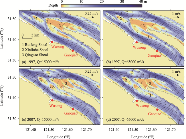
Figure 8 Residual currents under different river discharge and bathymetric conditions |
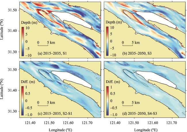
Figure 9 Model predictions of erosional/depositional patterns (a-b) and the differences between modeling scenarios (c-d) |
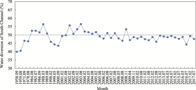
Figure 10 Variations in the ebb flow diversion ratio of the South Channel since 1958 |
Figure 11 Schematic framework of the channel-shoal adjustment in the South Channel during 1958-2018 |
| [1] |
|
| [2] |
|
| [3] |
|
| [4] |
Changjiang Water Resources Commission (CWRC), 2018. Changjiang Sediment Bulletin. Wuhan: Changjiang Press. (in Chinese)
|
| [5] |
|
| [6] |
|
| [7] |
|
| [8] |
|
| [9] |
|
| [10] |
|
| [11] |
|
| [12] |
|
| [13] |
|
| [14] |
|
| [15] |
|
| [16] |
|
| [17] |
|
| [18] |
|
| [19] |
|
| [20] |
|
| [21] |
|
| [22] |
|
| [23] |
|
| [24] |
|
| [25] |
|
| [26] |
|
| [27] |
|
| [28] |
|
| [29] |
|
| [30] |
|
| [31] |
|
| [32] |
|
| [33] |
|
| [34] |
|
| [35] |
|
| [36] |
|
| [37] |
|
| [38] |
|
| [39] |
|
| [40] |
|
| [41] |
|
| [42] |
|
| [43] |
|
| [44] |
|
| [45] |
|
| [46] |
|
| [47] |
|
| [48] |
|
| [49] |
|
| [50] |
|
/
| 〈 |
|
〉 |