Special Issue: Urban and Rural Governance Toward Sustainable Development Goals

The spatial pattern and governance of Zhongyuan Urban-Rural System in its development trajectory

  • FU Haiyue , 1 ,
  • WANG Yan 1 ,
  • MAO Liang 2 ,
  • HONG Nana 1 ,
  • WANG Zhaoya 1 ,
  • ZHAO Shuchang 1 ,
  • LIAO Chuan , 3, *
Expand
  • 1. School of Public Administration, Nanjing Agricultural University, Nanjing 210095, China
  • 2. Department of Geography, University of Florida, Gainesville 32611, USA
  • 3. School of Sustainability, Arizona State University, Tempe 85281, USA
*Liao Chuan (1987-), Assistant Professor, E-mail:

Fu Haiyue (1977-), Associate Professor, specialized in land use change and socio-ecological system. E-mail:

Received date: 2021-10-19

  Accepted date: 2022-02-24

  Online published: 2022-09-25

Supported by

National Natural Science Foundation of China(41871319)

State Scholarship Fund of China(201906855021)

Ideological and Political Demonstration Curriculum Construction Project of Nanjing Agricultural University(KCSZ2021053)

Abstract

It remains unclear on how transportation network interacts with economic network in an urban-rural agglomeration, while such knowledge is crucial for urban-rural system governance and sustainability. We explored such spatial interactions in the Zhongyuan Urban-Rural Agglomeration (ZURA) from 1995 to 2015. The structure of transportation network was measured by spatial syntax model, and that of economic network was gauged by improved gravity model. The associations between transportation and economic networks were investigated by conducting bivariate spatial autocorrelation analysis. The global Moran’s I showed that the two networks were positively correlated from 1995 to 2015. The local Moran’s I identified “high-high” associations between transportation and economic networks around core cities in 1995, which further extended to surrounding cities. Our results reveal that peripheral cities with highly developed transportation system have little spatial economic impact on neighboring rural areas, while cities with low transportation accessibility restrained its external economic influence of neighboring cities and rural areas. Our findings shed light on future urban-rural system governance, where the “multi-center, unbalanced” growth patterns of economic network and the “multi-core, multi-directional” structure of transportation network are more likely to contribute to the sustainability of urban-rural systems.

Cite this article

FU Haiyue , WANG Yan , MAO Liang , HONG Nana , WANG Zhaoya , ZHAO Shuchang , LIAO Chuan . The spatial pattern and governance of Zhongyuan Urban-Rural System in its development trajectory[J]. Journal of Geographical Sciences, 2022 , 32(7) : 1261 -1280 . DOI: 10.1007/s11442-022-1996-3

1 Introduction

Urban-rural agglomeration is a conceptual development model that takes one or more core cities as the major growth engine and driver of the development of surrounding cities and rural areas (Gottmann, 1957; Fang and Yu, 2017). Since the 1980s, China’s urban-rural agglomerations have been emerging as a result of rapid urbanization processes (Bai et al., 2014; Liu et al., 2014; Shu et al., 2018), and there are increasingly stronger connections among cities and rural areas. These agglomerations are considered as basic geographic units for engaging in global production and international division of labor (Yu et al., 2019). In the context of economic globalization and regional integration, governance has become an important theoretical and practical issue from local to global levels (Ye and Liu, 2020; Ye et al., 2020), and urban-rural agglomerations have become a new unit of spatial governance (Yang, 2020; Yang and Mi, 2020). Specifically, the Report of the 19th National Congress of China proposed to use urban-rural agglomerations as the main form to promote coordinated development of urban and rural areas. The coordinated governance of urban-rural agglomerations has become the focus of academic research and real-world practices. The main purpose of coordinated governance of urban-rural agglomerations is to solve the fragmentation problem caused by the barriers emerged from traditional administrative jurisdictions, which is a key challenge to effective urban-rural governance (Mi, 2019).
Spatial governance is also the key to the sustainable development of urban-rural agglomerations. The evolution of the spatial structure of urban-rural agglomerations follows its inherent development law. The agglomeration and diffusion of “regional flow” is the fundamental driving force of the evolution of the spatial structure of urban-rural agglomerations. The flow of various elements such as technology, information from concentration to diffusion will inevitably produce increasingly frequent and accelerated cross-region flows between cities, thus breaking the restrictions of existing administrative jurisdictions and generating cross-region collaborative networks (Mi, 2019).
As a popular model for integrated urban-rural development, the network model treats an urban-rural agglomeration as an organic entity formed by mutual cooperation and influence among cities, which can promote sustainable economic development in nearby areas (Meijers, 2005; De Goei et al., 2010; Ye et al., 2019). A city at the center of a network can exert a stronger influence on resource flows. The concentration and spread of economic and social factors in space has an important impact on the structure, function and development of urban-rural agglomerations. Commonly studied urban-rural networks include both tangible networks such as flight and ground transportation networks, and intangible networks such as economic network (Tang et al., 2013).
The transportation network is one of the most important components of tangible networks (Newman and Kenworthy, 1996; Tang et al., 2013), acting as the channel of economic and social connections within an urban-rural agglomeration (Jin et al., 2010). Accessibility is an opportunity for interaction between cities and an important indicator of the structure and efficiency of a transportation network (Hansen, 1959; Chacon Hurtado et al., 2020). The accessibility of transportation network determines whether the resource flow between cities is smooth and has become an indispensable material condition for the development of urban-rural agglomerations. The related research mainly focused on urban road networks (Xiao et al., 2017), rail transit (Gutiérrez and Urbano, 1996; Chen et al., 2014), railways (Meng and Lu, 2012; Yu et al., 2021) and other single land transportation systems (Wang et al., 2017). Existing research on transportation accessibility in China has mainly focused on economically developed areas such as Wuhan Metropolitan Agglomeration (Liu and Yu, 2012), Pearl River Delta Urban Agglomeration (Feng et al., 2014), and Yangtze River Delta Urban Agglomeration (Wu et al., 2020), while integrated transportation network systems in the inland urban-rural agglomerations are understudied (Liang et al., 2017).
The economic network, based on economic activities, is one of the most important components of intangible networks (Tang et al., 2013). It is formed through the flow of elements among networks, and its load capacity and expansion capacity can be strengthened, which can increase connections with other economic networks and provide support for regional integrated development. As the spatial structure of urban-rural agglomerations evolves from a single center to multiple centers, the research on the economic connection of urban-rural agglomerations has also evolved from the analysis of economic connection between nodes to the exploration of economic links within the region (Hu and Liu, 2009; Tang et al., 2013). The research perspective mainly includes the discussion of regional economic linkage mechanism (Matsumoto, 2004).
In recent years, scholars have gradually shifted their research focus from spatial connections within a single transportation or economic network to associations between them, such as the coordination of transportation network and economic network (Ersoy, 2016; Ibáñez and Rotoli, 2017) and the impact of the transportation network evolution on economic growth (Li et al., 2016; Chen et al., 2020; Gao et al., 2020). The relationship between transportation network and economic connection is different across development stages. The study of a certain time period or short time series cannot scientifically analyze the relationship and changes between them.
In the existing research, the research subjects of urban-rural agglomeration networks were mostly limited to individual tangible or intangible networks, mainly exploring its network structure and evolution process. In China, the research area was also mainly confined to economically developed coastal areas. Regarding the research on relationship between the transportation network and the economic connection, most of them focus on the matching degree between the traffic accessibility and economic development level. Studies generally suggest that the compression of regional spatial distance has a significant promotion effect on the evolution of economic networks, but ignores the spatial spillover effect of transportation accessibility. Few studies have explored the influence of tangible networks on intangible networks in urban-rural agglomerations. Transportation networks not only affect the economic impact of cities, but also the economic connections with neighbor cities.
This article aims to address the above knowledge gaps by taking Zhongyuan Urban-Rural Agglomeration (ZURA) in China as the study area. Specifically, the objectives are to: (1) characterize the economic network and transportation network in ZURA from 1995 to 2015; (2) investigate the spatial associations between the transportation network and the economic network in this time period; and (3) put forwards suggestions on coordinated governance and optimization of the spatial networks structure. Findings from our research shed policy implications towards optimizing the spatial structure of urban-rural agglomerations and improving the regional coordination for sustainable development.

2 Study area

The Zhongyuan Urban-Rural Agglomeration (ZURA) is located in the interior of China, and is a new growth engine for China’s overall economic development (Figure 1). The development plan of ZURA was reviewed and approved by the State Council of China in 2016 and the ZURA was officially identified as a national-level urban agglomeration. According to the plan, the urban-rural agglomeration consists of 30 prefecture-level cities in 5 provinces, including all 18 cities in Henan province, Xingtai and Handan in Hebei province, Suzhou, Huaibei, Fuyang, Luzhou, and Bengbu in Anhui province, Liaocheng and Heze in Shandong province, and Changzhi, Jincheng, and Yuncheng in Shanxi province.
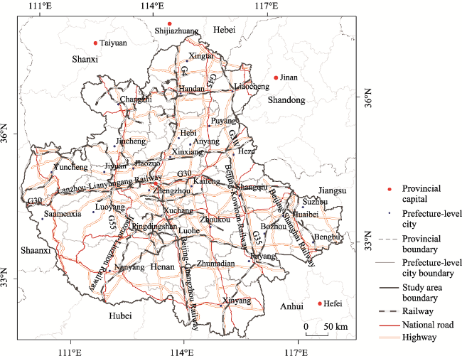
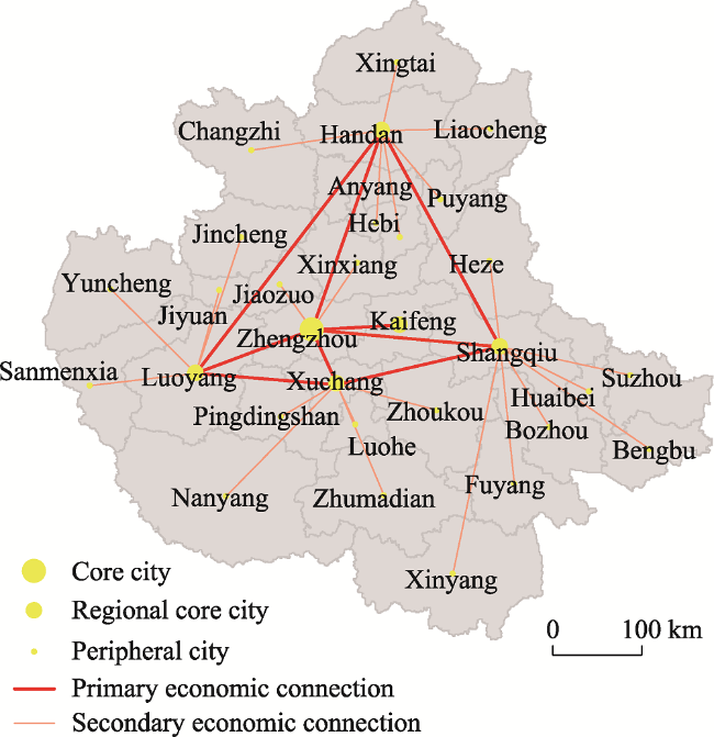
Figure 1 The road and railway network of the Zhongyuan Urban-Rural Agglomeration, China
The total area of ZURA is 287,000 km2. By the end of 2017, the resident population reached 163 million and the GDP was 77.81 billion RMB. It is the fourth largest agglomeration, following the three highly developed ones in the Yangtze River Delta, the Pearl River Delta, and Beijing-Tianjin-Hebei region.
The transportation network is composed of several artery railways and highways, such as Beijing-Guangzhou and Lanzhou-Lianyungang railways, Beijing-Zhuhai (G4) and Lianyungang-Khorgos (G30) highways.
Since ZURA was officially identified as a national-level urban agglomeration in 2016, we focus on the first 20 years before ZURA was approved a national-level urban-rural agglomeration as our study period in our investigation of its spatial pattern. This study takes the year 1995 as the starting point. Considering data availability, our study period spans from 1995 to 2015, with a five-year interval.

3 Methods and data

3.1 Measuring the economic network

We calculated economic connection potential of the city Ei to measure the overall strength of connection from one city to all other cities in the economic network as:
${{E}_{\text{i}}}=\sum\limits_{j=1}^{n}{{{F}_{ij}}}$
where Ei indicates economic connection potential of city i, Fij is the economic connection strength between city i and city j, and n is the number of the cities in ZURA.
The economic connection strength between cities Fij is used to analyze regional influence by determining the main direction and connection degree. It follows the law of mutual attraction. According to the principle of distance attenuation, the connection strength decreases as the distance increase between cities. The higher the economic connection, the stronger the spatial interaction forces of cities.
We applied an improved gravity model to calculate the economic connection strength between cities in ZURA as below:
${{F}_{ij}}={{k}_{ij}}\times \frac{{{M}_{i}}\text{ }{{M}_{\text{ }j}}}{T_{ij}^{b}}$
where Fij is the gravity between city i and city j, Mi and Mj are the “feature” of city i and city j, respectively, Tij is the distance of between city i and city j. b is the distance attenuation coefficient, and k is the empirical coefficient.
Since we analyze economic connections between cities, the “feature” of each city is more focused on economic development at the city level. Individual citizens are the main agents performing economic activity and contributing to economic development. We use year-end total population and GDP to replace the Mi and Mj in the above gravity model. Because the strength of the economic relationship between two cities is non-equivalence, we use the total of urban GDP to the sum of GDP of two linked cities to modify the empirical constant k. The distance between two cities Tij uses the economic development gap between cities instead of geography distance, that is, the difference in per capita GDP between cities, and the distance attenuation coefficient b is determined to be “2” according to empirical research by Taaffe (Taaffe, 1962). The improved gravity equation is then formulated as:
${{F}_{ij}}=\frac{{{G}_{i}}}{{{G}_{i}}+{{G}_{j}}}\times \frac{\sqrt{{{G}_{i}}{{P}_{i}}}\times \sqrt{{{G}_{j}}{{P}_{j}}}}{{{(E{{P}_{i}}-E{{P}_{j}})}^{2}}}$
where Gi, Gj and Pi, Pj are the GDP and the total population of city i and city j at the end of the year, respectively; EPi and EPj are the per capita GDP of city i and city j, respectively.
In this study, the 30 cities are used as the nodes of the economic network of ZURA. We obtained the data of the year-end GDP and total population in 1995, 2000, 2005, 2010, and 2015 for the 30 cities from the “City Statistical Yearbook” and “China City Statistical Yearbook” of each city and provincial-level region.

3.2 Measuring the transportation network

3.2.1 Road axis accessibility

The accessibility of road axis can reflect the accessibility of the area. Based on the spatial syntax model metrics, we constructed the road accessibility Ti as:
${{T}_{i}}\text{=}\sum\limits_{j=1}^{n}{{{L}_{j}}}$
where n is the number of other roads connected to the road i, Lj is the spatial syntax accessibility metrics.
Since the literature suggests that integration degree is one of the most commonly used and most effective parameters in space syntax models (Liu and Yu, 2012), the Lj can be substituted by the global integration (RRAi). The equation is the following.
RRAi=RAi/Sn
where Sn=2×{n×[log2((n+2)/3)–1]+1}/[(n–1)(n–2)], RAi is the local integration calculated by RAi=2×(MDi–1)/(n–2) and n is the total number of road axes in the city. MDi represents the average depth value of the nodes calculated by $M{{D}_{i}}=\sum\limits_{b=1}^{m}{\frac{{{d}_{ib}}}{(m-1)}},\ (b=1,2,3,...,m)$, where dib represents the shortest distance between i and b two nodes, m represents the number of nodes of the connected axis.

3.2.2 Comprehensive accessibility of the city

The spatial syntax model is streamlined by converting the spatial connections into a connection graph and analyzing the deformation according to the graph theory (Bafna, 2003). It is basically a method of measuring network accessibility based on topological distance, without taking into account attributes such as speed of traffic flow.
The speed of different types of roads is different, which affects the accessibility of transportation network. Therefore, we assign a weight to different types of roads according to their average speed to calculate the accessibility of roads. The comprehensive accessibility of the city is the weighted sum of accessibility of different types of road.
In this study, the road types were classed into three types: railway, highway, and national road. The comprehensive accessibility of the city is calculated by equation 6.
T=QR×TR+QHW×THW+×QNR×TNR
where T is the comprehensive accessibility of the city. TR, THW and TNR represent the axis accessibility of three types of roads: rail, highway and national road, respectively. QR, QHW and QNR are the accessibility weights of the above three types of roads, respectively, which are calculated by ${{Q}_{ij}}=\frac{{{V}_{ij}}}{{{V}_{iR}}+{{V}_{iHW}}\text{+}{{V}_{iNR}}}$, where, Qij represents the weight of road type j in year i, Vij is the average velocity for road type j in year i, ViR, ViHW, ViNR represent velocity of the railway, highway, and national road in year i, respectively. Appendix Table 1 shows the average speed and weights of different types of roads of ZURA in 1995, 2000, 2005, 2010, and 2015.
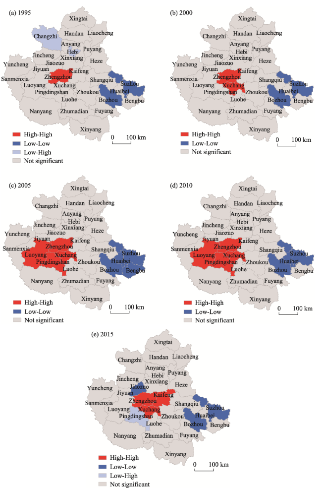
Table 1 Moran’s I of between the comprehensive accessibility and the economic connection potentials of cities of the Zhongyuan Urban-Rural Agglomeration in 1995, 2000, 2005, 2010, and 2015
1995 2000 2005 2010 2015
Moran’s I 0.138 0.202* 0.240** 0.208* 0.184*

Note: **, and * indicate significance at 1%, and 5% level respectively.

The spatial data of railways, highways and national roads of ZURA are retrieved from ArcGIS ONLINE data (2015). The boundary of the administrative unit of the prefecture-level city is used to overlay with the transportation road data, making the spatial syntax model suitable for large-scale spatial accessibility analysis (Liang et al., 2017).
The study first confirmed all other axes connected to each axis through the spatial connection function of ArcGIS, and calculated their depth value, local integration degree, and global integration degree and then calculated the road axis accessibility and comprehensive accessibility of each city in ZURA according to formulas (4)-(6).

3.3 Spatial autocorrelation analysis on economic and transportation network

The global bivariate Moran’s I statistic is used to measure the spatial association between measures from the economic and transportation networks. The weight matrix was defined based on whether two cities share their borders.
To further uncover local influence of transportation accessibility on economic connection, the local bivariate Moran’s I was used (Anselin, 1995). Four types of spatial relationships between comprehensive accessibility and economic connection potential of cities distribution are identified, namely high-high, low-low, high-low, and low-high. High-high means a city with high comprehensive accessibility is surrounded by cities with high economic connection potential. The positive high-high and low-low spatial autocorrelation indicate spatial clustering of similar values (high comprehensive accessibility surrounded by high economic connection potential and vice versa) and the negative high-low and low-high indicate spatial clustering of dissimilar values.

4 Spatial pattern of economic and transportation networks

4.1 Characteristics of economic and transportation networks

4.1.1 Analysis of economic connection potential of cities

If an urban-rural agglomeration was set as a closed area, the economic connection strength between cities is the line with direction. Based on the economic connection strength in 2015, the economic connection strength of 30 cities was classified into five levels by the natural breakpoint method (Figure 2). From 1995 to 2005, the economic connection strength between cities was weak, but the number of effective and higher economic links of ZURA increased significantly. The cities along the Lanzhou-Lianyungang and the Beijing-Guangzhou railways have obviously higher economic connection.
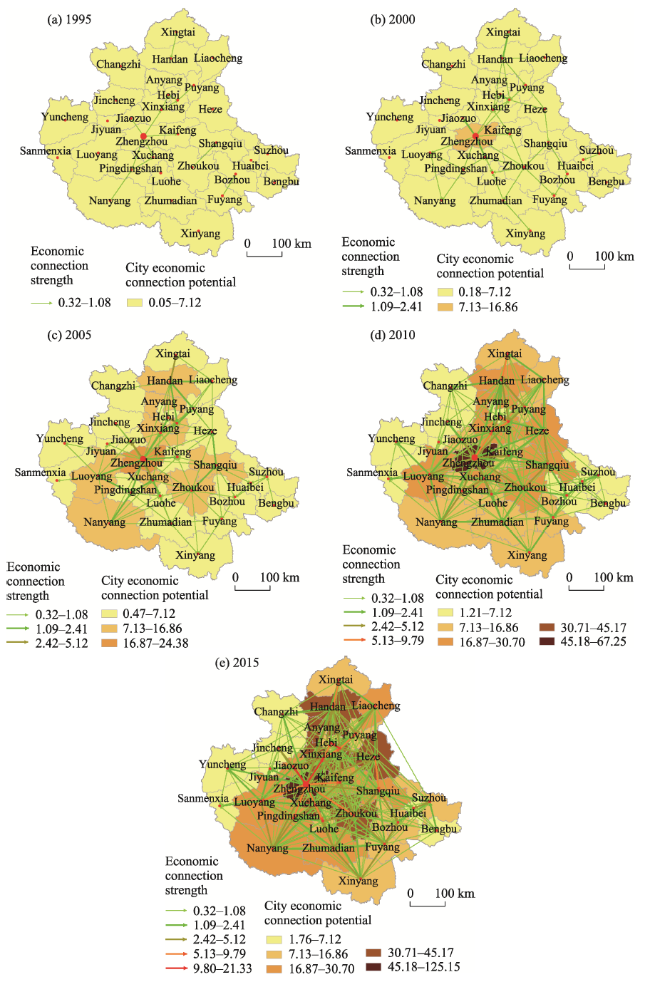
Figure 2 The economic connection strength and potential of cities of the Zhongyuan Urban-Rural Agglomeration in 1995, 2000, 2005, 2010, and 2015
The economic connection potentials of 30 cities in ZURA in 1995, 2000, 2005, 2010, and 2015 varied considerably (see Appendix Table 2). They were also classified into five levels by the natural breakpoint method base on the data in 2015 (Figure 2). The economic connection potential of each city has shown an increase in ZURA from 1995 to 2015. The economic connection potentials of Zhengzhou, Anyang and Zhoukou had increased rapidly, from 5.29, 3.55, and 2.87 in 1995 to 125.15, 45.17, and 21.98 in 2015, an increase of 23.66, 12.72, and 13.54 times, respectively. The increasing speed of economic connection potential of each city during 1995-2005 was faster than those of during 2005-2015. After 2005, the growth rate of economic connection potential of each city had increased significantly. However, the imbalance and the polarization among cities in ZURA had become increasingly obvious. The economic connection potentials of cities along the Beijing-Guangzhou railway were significantly higher than those of cities along the Lanzhou-Lianyungang railway. At the same time, the economic connection potentials of central and northern cities along the Beijing-Guangzhou railway were higher than those of the southern cities along the Beijing-Guangzhou railway. The overall structure of the economic connection potentials of cities in ZURA presented a layout of “high in the north, low in the south, and high in the middle, low around” and “right-leaning in Zhengzhou”.
In addition, the economic connection potential in Hebi surrounded by Xinxiang and Anyang with higher economic connection potential was always lower from 1995 to 2015. The economic connection potential in Zhengzhou and its surrounding cities were significantly higher than those of the other cities, which showed the “Matthew Effect”.

4.1.2 Analysis of the comprehensive accessibility of cities

The changes of road axis accessibility in ZURA in 1995, 2000, 2005, 2010, and 2015 are shown in Figure 3. From 1995 to 2015, cities with higher road axis accessibility in ZURA continued to increase. As the core city of ZURA, Zhengzhou had relatively high accessibility to its road axes. In 1995, the road with higher axis accessibility was mainly distributed in Zhengzhou. From 2000 to 2010, the road accessibility in Xinxiang, Kaifeng and Xuchang became higher subsequently. By 2015, the road accessibility in the surrounding cities of Zhenzhou such as Luoyang, Xuchang, Zhoukou, Shangqiu, and Kaifeng gradually became higher. The road axis accessibility of all cities in Henan is at a high level. The road axis accessibility in Hebei, Shandong and Anhui in ZURA were relatively scattered, due to the fact that the cities are located on the edge of ZURA.
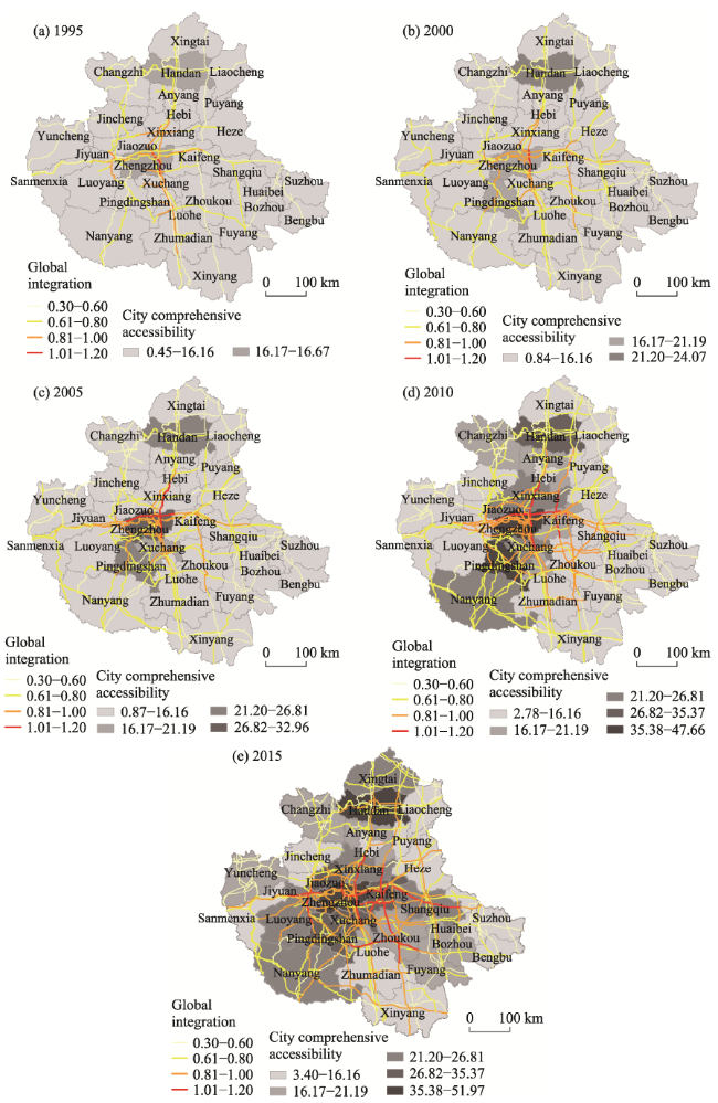
Figure 3 The road axis accessibility and comprehensive accessibility of cities of the Zhongyuan Urban-Rural Agglomeration in 1995, 2000, 2005, 2010, and 2015
The road axis with higher accessibility of ZURA had developed from a regional linear distribution in 1995 to a planar distribution of accessible central areas in 2015. However, the spatial network structure of the road axis accessibility of ZURA had developed from a tree shape in 1995 to a “concentric circle” shape in 2015.
The comprehensive accessibility of 30 cities in 1995, 2000, 2005, 2010, and 2015, the growth rate of comprehensive accessibility during 1995-2005 and 2005-2015, and the gap between the comprehensive accessibility growth rates of the two periods of 30 cities indicated in the appendix Table 3.The comprehensive accessibility of cities was also classified into five levels by the natural breakpoint method base on the data in 2015 (Figure 3). Comprehensive accessibility ranges for the five time sections of 1995, 2000, 2005, 2010, and 2015 in ZURA are (0.45, 16.67), (0.84, 24.07), (0.87, 32.96), (2.78, 47.66) and (3.40, 51.97). The ranges of comprehensive accessibility values have been expanding, and the gap in comprehensive accessibility between cities was growing in 1995-2015. The comprehensive accessibility growth rate of 60% of cities in ZURA in 2005-2015 was less than that of 1995-2005. The growth rate of comprehensive accessibility of core cities such as Zhengzhou and Anyang was slowing down, while the growth rate of comprehensive accessibility of peripheral cities such as Suzhou and Huaibei was increasing. It showed that core city transportation network was maturing and the construction pace had slowed down, while the peripheral city transportation network was still in the high-speed construction period, showing a trend of spatial convergence.
From 1995 to 2005, the comprehensive accessibility of Zhengzhou, Handan, Anyang, Pingdingshan, Xuchang, and Xinxiang along the Beijing-Guangzhou railway had been greatly improved, while the comprehensive accessibility of the cities along the Lanzhou-Lianyungang railway were relatively lower (less than 16.16 ).
From 2005 to 2015 the overall comprehensive accessibility of ZURA had improved in quality, and the comprehensive accessibility of cities along the Beijing-Guangzhou railway had further developed. Only Hebi was still at a low comprehensive accessibility value (less than 16.16). The comprehensive accessibility of the cities influenced by Lanzhou-Lianyungang railway had also improved significantly, but it was still lower than those influenced by the Beijing-Guangzhou railway. In general, the low-value cities (less than 16.16) of the comprehensive transportation accessibility of ZURA continued to shrink and the transportation network structure was gradually improved, but the gaps of the comprehensive accessibility between cities were gradually increasing.

4.2 Spatial effects of transportation accessibility on economic connection

4.2.1 Spatial autocorrelation between transportation accessibility and economic connection

The results show that the bivariate global Moran’s I of the city’s comprehensive accessibility and the economic connection potential was 0.138, 0.202, 0.240, 0.208 and 0.184 respectively in 1995, 2000, 2005, 2010 and 2015 (Table 1). Among them, the global Moran’s I was not significant in 1995, while the global Moran’s I in 2000, 2010 and 2015 were significant at 5% level, while the global Moran’s I in 2005 was significant in at 1% level using permutation approach for inference with 999 permutations. This suggested that transportation network, from the global view, had significant positive spatial autocorrelations with economic network.
In general, the global Moran’s I from 1995 to 2015 presented the trend of “increase-decrease” and the turning point was 2005, which showed that the correlation between the two networks gradually strengthened and was strongest in 2005, then started to decline.

4.2.2 Local spatial variations of transportation accessibility on economic connection

Figure 4 shows the distributions of four types of spatial relationships between the comprehensive accessibility and the economic connection potential of cities and their significance of bivariate local Moran’s I of ZURA in 1995, 2000, 2005, 2010, and 2015. It is evident that the spatial associations of transportation accessibility with economic connection vary greatly in ZURA from 1995 to 2015. Positive high-high associations were mainly identified in Zhengzhou in 1995 then expanded to surrounding cities such as Kaifeng, Xuchang. The “low-low” associations had always been identified in Bozhou and Suzhou in Anhui. The transportation accessibility of this kind of cities was low, and it cannot produce a good mutual promotion economic effect with neighboring cities.
Figure 4 LISA cluster maps of economic connection potential-comprehensive accessibility of cities of the Zhongyuan Urban-Rural Agglomeration in 1995, 2000, 2005, 2010, and 2015
The spatial correlation between transportation accessibility and economic connection in Pingdingshan was insignificant in 1995, 2000, while positive “high-high” in 2005, 2010 and negative “low-high” in 2015. Pingdingshan is located in the core area of ZURA, with well-developed transportation, but its surrounding cities’ economic impact was not high. The main reason was that Pingdingshan’s economic development relied too heavily on economic impact from cities such as Zhengzhou and Xuchang, which resulted in its low outward influence and cannot generate good economic mutual promotion with surrounding cities.
There were no “high-low” correlations identified in ZURA, indicating cities with mature transportation system will not necessarily drive the surrounding cities’ external economic impact. But cities with immature transportation network conditions will demonstrate the external economic impact on neighboring cities.

5 Policy implications on coordinated spatial governance

Our findings suggest there is a co-evolution relationship between the regional governance model and the spatial structure of urban-rural agglomerations. This co-evolution relationship reveals that different regional governance models are needed at different development stages of urban-rural agglomerations. The “urban agglomeration diseases” in the development of existing urban agglomerations, such as industrial homogeneity, fragmentation of public services, traffic congestion, and environmental degradation, are largely due to the fact that the urban-rural agglomeration governance model is poorly matched to the co-evolution of the spatial structure of urban-rural agglomerations. Therefore, exploring the co-evolution mechanism of spatial structure clustering and regional governance model is of great significance to the effective governance of urban-rural agglomerations.
In the stage of urban-rural agglomeration spatial networking, the “resource flow” connection within the urban-rural agglomeration accelerates, and the diffusion effect of core cities is stronger than the agglomeration effect. The simple “line” spatial connection between cities can no longer meet the demand of coordinated development within an urban-rural agglomeration. Therefore, it is necessary to establish a complex urban-rural system of “functional complementarity, orderly structure, overall optimization, symbiosis and sharing, and relationship coordination” between urban-rural regions. In such a complex urban-rural system, the horizontal links between cities are strengthened, and the vertical subordination relationship is weakened.
Therefore, we first propose the policy recommendation of coordinated urban and rural governance, and then put forward suggestions on the optimization of the economic spatial structure of ZURA. As one of the most basic tangible networks, development of transportation network contributes to the optimization of economic network structure. So we propose further suggestions for improving the transportation network based on the goals of the ideal economic connection network structure.

5.1 Coordinated urban and rural governance

Urban-rural agglomerations are not only the most dynamic and potential growth engine in China’s economic development, but also fulfill the multiple tasks of maintaining national ecological security, promoting urban-rural governance and facilitating integrated development.
National governance space should reflect hierarchical units. At present, urban and rural communities are the basic units of national governance. On top of the basic governance unit, we must build an in-between-level governance unit to coordinate and solve the increasingly complex national governance problems, so as to improve the national governance unit system. Urban-rural agglomerations solve the practical problems such as disorderly competition between local governments, repeated investment, and exacerbation of urban-rural disparity. It can flexibly deal with the cross regional governance problems in practice, and provide a more operational governance unit for realizing the coordinated development of urban and rural areas and effective national governance (Yang and Mi, 2020). It can be used as an intermediate level governance unit. Urban and rural governance should be implemented from the macro-national strategy to the micro-community scale level by level, so as to fully stimulate the vitality of community governance, create resilient communities, and realize the coordinated governance of urban and rural areas.
In addition, urban and rural governance should also address the issue of “spatial justice”. Urban-rural redevelopment and regeneration are spatial development processes that consist of revitalizing or reorganizing cities that are declining or have been developed without compliance to modern principles of spatial planning in order to create new and futuristic cities (Zheng et al., 2014). When those processes are undertaken following a neoliberalization paradigm, they are likely to exacerbate spatial injustices (Enright, 2019). Considering that spatial and environmental injustices can severely affect the structure and functioning of urban-rural agglomerations, we believe that the principle of spatial justice should be followed in the process of urban-rural co-governance (Uwayezu and De Vries, 2018). Therefore, urban-rural co-governance should focus on people-oriented development, be based on equality and openness, and aim at achieving common prosperity.

5.2 Optimization of spatial structure

We proposed that the “multi-center unbalanced growth” pattern of economic network and the “multi-core, multi-directional” structure of transportation network should be adopted for sustainable urban-rural development.

5.2.1 Optimization of economic network structure

ZURA demonstrated a homogeneous exhibition status as a whole, and the polycentric economic network had formed between 1995 and 2015. However, although Zhengzhou has always been the core city of ZURA, its functions were limited and it cannot sufficiently sustain the growth of the entire urban-rural agglomeration. At the same time, various specialized center cities such as Jiaozuo, Xinxiang, Kaifeng, Luoyang and other cities can hardly share any functions with Zhengzhou.
Therefore, we propose urban-rural integrated development structure consisting of core cities, regional core cities and peripheral cities, and take the central cities and regional centers of Kaifeng, Zhengzhou and Shangqiu, Xuchang, Luoyang and Handan as the core, break the administrative boundaries, and establish an urban-rural governance model with vertical transmission, horizontal linkage and multi-directional interaction of multi-scale administrative subjects covering “city - district - town - community (village)” in ZURA.
The policy should be appropriately prioritized to develop core and regional core cities, and drive the peripheral cities to develop according “multi-center non-balanced” growth model (Figure 5). ZURA will realize the coordinated development through the primary economic connection (between core and regional core cities) and the secondary economic connection (between regional core and peripheral cities).
Figure 5 Conceptual patterns of multi-center non-balanced of economic network of the Zhongyuan Urban-Rural Agglomeration
In terms of optimizing the overall structure of the economic network in ZURA, the core city’s growth engine effect should be strengthened first. Specifically, it is necessary to accelerate the development of “Zhengzhou- Kaifeng integration” for creating a bigger growth engine for ZURA. So we proposed that Zhengzhou and Kaifeng were chosen as the first and secondary core cities of ZURA so as to strengthen the external economic impact of the growth engine of ZURA. Shangqiu, Xuchang, Luoyang, and Handan are located the surrounding of the “cross shape” development axis of Lanzhou-Lianyungang and Beijing-Guangzhou railways. Due to their excellent geographical locations, higher economic connection potentials and transportation accessibility, Shangqiu, Xuchang, Luoyang, and Handan were chosen as the regional core cities in the eastern, southern, western, and northern regions of ZURA, respectively as bridges between the peripheral cities and the core cities, and playing a role of the “broker” for the economic integrated development in ZURA.
On the one hand, it should focus on the economic connection between the core cities of Zhengzhou, Kaifeng and the regional core cities of Shangqiu, Xuchang, Luoyang, and Handan to increase the economic connection of ZURA. According to the resources and advantages of cities, the division of functions will be optimized, the infrastructure will be shared, and the industrial space will be coordinated to achieve core leadership and joint development of the five regions.
On the other hand, it should also pay attention to the linkage between the core, regional core and the peripheral cities. The cities of Anhui, Shandong, and Shanxi, which are located on the edge of ZURA, are relatively low in economic connection potentials. Therefore, it is necessary to clearly position these peripheral cities function and the industrial chains with other cities, and actively use the regional core cities of Shangqiu, Xuchang, Luoyang and Handan to establish communication links with core cities of Zhengzhou and Kaifeng.

5.2.2 Optimization of transportation network structure

Based on the “multi-center unbalanced” pattern of the economic network, we proposed the “multi-core, multi-directional” structure of the transportation network in ZURA. The cross axis of the Lanzhou-Lianyungang and Beijing-Guangzhou railways is the basis frame of the transportation network. The Kaifeng, Zhengzhou and Shangqiu, Xuchang, Luoyang and Handan are the important transportation node cities in the central, eastern, southern, western, and northern parts of ZURA. This transportation network structure contributes to forming a material circulation channel that links core, regional core and periphery cities, increasing the impact of the core cities, and strengthening the economic connection between cities.
It is important to note that the construction of road networks primarily focusing on connecting core cities may exacerbate the spatial injustice between urban and rural areas. Although there are many highways penetrating through the rural areas, the villagers may not have access to these highways because there are no entries to these highways in the rural areas. Therefore, future policies on coordinated urban-rural development should avoid such “tunnel effect” that largely ignores the development demand of rural areas based on spatial justice (Enright, 2019).

6 Discussion

The influence of both tangible and intangible networks has become a focus of recent academic inquiry on urban-rural agglomerations of China. However, previous studies have largely confined to a single transportation or economic network structure and its evolution process in developed urban-rural agglomeration of China. ZURA is a typical government-led urban-rural agglomeration due to its formation motivation. This research contributes an in-depth study on the spatial integration and development of ZURA. Our findings also shed light on the integrated development of the government-led urban-rural agglomeration.
The economic network structure of ZURA tends to develop rapidly and the advantages of Zhengzhou’s “core” growth engine are obvious. However, it cannot sufficiently sustain the development of the entire ZURA from 1995 to 2015. In addition, there are development challenges including “polarization” and “Matthew Effect”. In the future, it is necessary to strengthen the coordinated development of both peripheral and core cities, and promote the full flow of various resources between cities and the surrounding rural areas. At present, the economic impact of ZURA is still under transition. At the same time, the economic connection between cities are not only related to factors such as total economic volume, population, and distance, but also to factors such as the city’s economic structure, industrial division of labor, and administrative divisions. Therefore, future research needs to include more variables to improve the gravity model and objectively calculating the strength of economic connection between cities and their surrounding rural areas.
Although the transportation network of ZURA is becoming increasingly complex and the transportation axis is constantly developing, the high-accessibility axis is still highly concentrated in the central area with Zhengzhou as the core from 1995 to 2015. The core-pherphery effect of the transportation accessibility of ZURA is obvious. Overall, the transportation accessibility of the central and eastern regions has improved faster than other regions, consistent with trends of the regional economic development.
We used exploratory spatial data analysis to investigate spatial associations between transportation network and economic network in ZURA. We found that the economic and transportation networks were positively correlated from 1995 to 2015 in ZURA. The economic impact of the city was not only related to its own transportation system, but also affected by the transportation system of neighboring cities. The global Moran’s I value was the lowest and did not pass the significance test in 1995, indicating that the transportation network of ZURA was not able to generate a good promotion effect on the economic network due to the underdeveloped transportation system. The global Moran’s I value was on the rise between 2000 and 2005, indicating that the transportation network of ZURA has been continuously improved and promoted the region’s external economic impact. But after 2005, the promotion effect of transportation network on economic network was weakening due to the gradually developed transportation system.
We also put forward the suggestion of economic network structure of “multi-center unbalanced growth patterns” and transportation network structure of “multi-core, and multi-direction”. By adjusting the spatial structure of ZURA, the city size and functions will be improved in the overall economic network, and ZURA will become more resistant to external shocks. At the same time, with the influence of resource mobility, the spatial structure between cities no longer strictly maintains the characteristics of “center-hinterland”, but is manifested as a connection with other urban-rural systems beyond the hinterland. As a result, the economic network of ZURA will be gradually shifting from a central location model to a multi-center network model. Future research should focus on investigating how to alleviate the issue of “spatial injustice” between urban and rural areas in the development of transportation network.
However, the spatial integration of urban-rural agglomerations must comprehensively consider all aspects of urban-rural system, infrastructure construction, industry, environmental protection, and ecological construction. Future research needs to take a holistic, multi-disciplinary approach to advance the sustainability of urban-rural agglomerations.

7 Conclusions

This article, taking ZURA as the study area, has explored the spatial structure of transportation network and economic network. It has further uncovered the spatial effect of transportation network on economic network, and offered suggestions for improving the economic and transportation networks structure towards synergistic urban-rural development. Large-scale spatial governance faces a more complex dynamic situation of the overall environment, target objects, and governance elements (Dietz et al., 2003). Therefore, in governance practice, reasonably matching specific spatial scales and governance measures (Ostrom, 2009), and establishing a nested hierarchical structure (Berkes et al., 2006) will be the direction of spatial governance of urban-rural agglomeration.
Specifically, our research has four major findings. First, the effective economic connection potential of each city in ZURA had been increasing from 1995 to 2005. The overall structure of economic connection potentials of cities in ZURA presented a layout of “high in the south, low in the north, high in the middle, and low around” and “right-leaning in Zhengzhou”.
Second, cities with higher road axis accessibility were mainly distributed in Zhengzhou and its surrounding cities, such as Luoyang, Xuchang, Zhoukou, Shangqiu, and Kaifeng from 1995 to 2015. The comprehensive accessibility of cities along the Lanzhou-Lianyungang railway was lower than those along the Beijing-Guangzhou railway. The spatial network structure of the transportation accessibility of ZURA had developed from a tree shape in 1995 to a “concentric circle” shape in 2015.
Third, the economic connection and transportation accessibility of cities were positively correlated from 1995 to 2015. The correlation was the strongest in 2005, and then started to decline. “High-high” associations were mainly identified around core cities such as Zhengzhou in 1995, which were further found around other cities such as Kaifeng, Xuchang. “Low-low” associations were found around some of peripheral cities such as Bozhou and Suzhou. “Low-high” associations were mainly identified in Changzhi and Hebi in 1995, Pingdingshan in 2015 and no “high-low” associations were identified. This result implies that peripheral cities with highly transportation accessibility have little spatial impact on neighboring cities and rural areas, and that cites with low transportation accessibility restrained the external economic influence of neighboring cities and rural areas.
Finally, our findings suggest that the “multi-center unbalanced growth” pattern of economic network and the “multi-core, multi-directional” structure of transportation network should be considered for sustainable urban-rural development. The entire Henan province should be taken as the main area for development, Zhengzhou and Kaifeng as the growth engine, and it is necessary to adopt a zoning network and circle-level development approach. It is recommended to take the Lanzhou-Lianyungang railway and the Beijing-Guangzhou railway as the “cross” development axis, based on the five districts of the middle, east, south, west, and north of ZURA, and breaks the municipal administrative boundaries to develop the infrastructure to facilitate synergistic urban-rural development at the regional level.
[1]
Anselin L, 1995. Local indicators of spatial association: LISA. Geographical Analysis, 27(2): 93-115.

DOI

[2]
Bafna S, 2003. Space syntax: A brief introduction to its logic and analytical techniques. Environment and Behavior, 35(1): 17-29.

DOI

[3]
Bai X M, Shi P J, Liu Y S, 2014. Society: Realizing China’s urban dream. Nature News, 509: 158-160.

DOI

[4]
Berkes F, Hughes T P, Steneck R S et al., 2006. Globalization, roving bandits, and marine resources. Science, 311: 1557-1558.

PMID

[5]
Chacon Hurtado D, Kumar I, Gkritza K et al., 2020. The role of transportation accessibility in regional economic resilience. Journal of Transport Geography, 84: 102695.

DOI

[6]
Chen S P, Claramunt C, Ray C, 2014. A spatio-temporal modelling approach for the study of the connectivity and accessibility of the Guangzhou metropolitan network. Journal of Transport Geography, 36: 12-23.

DOI

[7]
Chen Z H, Li Y, Wang P, 2020. Transportation accessibility and regional growth in the Greater Bay Area of China. Transportation Research Part D: Transport and Environment, 86: 102453.

DOI

[8]
De Goei B, Burger M J, Van Oort F G et al., 2010. Functional polycentrism and urban network development in the Greater South East, United Kingdom: Evidence from commuting patterns, 1981-2001. Regional Studies, 44(9): 1149-1170.

DOI

[9]
Dietz T, Ostrom E, Stern P C, 2003. The struggle to govern the commons. Science, 302: 1907-1912.

DOI

[10]
Enright T, 2019. Transit justice as spatial justice: Learning from activists. Mobilities, 14(5): 665-680.

DOI

[11]
Ersoy A, 2016. Impact of accessibility and knowledge creation on local and regional development in Turkey. Growth and Change, 47(4): 648-663.

DOI

[12]
Fang C L, Yu D L, 2017. Urban agglomeration: An evolving concept of an emerging phenomenon. Landscape and Urban Planning, 162: 126-136.

DOI

[13]
Feng C C, Xie D X, Ma X et al., 2014. Functional polycentricity of the urban region in the Zhujiang River Delta based on intercity rail traffic flow. Scientia Geographica Sinica, 34(6): 648-655. (in Chinese)

[14]
Gao X, Zhang A L, Sun Z L, 2020. How regional economic integration influence on urban land use efficiency? A case study of Wuhan metropolitan area, China. Land Use Policy, 90: 104329.

DOI

[15]
Gottmann J, 1957. Megalopolis or the urbanization of the northeastern seaboard. Economic Geography, 33(3): 189-200.

DOI

[16]
Gutiérrez J, Urbano P, 1996. Accessibility in the European Union: The impact of the trans-European road network. Journal of Transport Geography, 4(1): 15-25.

DOI

[17]
Hansen W G, 1959. How accessibility shapes land use. Journal of the American Institute of Planners, 25(2): 73-76.

DOI

[18]
Hu A G, Liu S L, 2009. Transportation, economic growth and spillover: Conclusion based on spatial econometrics. China Industrial Economics, (5): 5-14. (in Chinese)

[19]
Ibáñez J N, Rotoli F, 2017. Measuring the impact of the trans-European road transport network on the accessibility of European urban agglomerations. Transportation Research Record, 2605(1): 72-82.

DOI

[20]
Jin F J, Wang C J, Li X W et al., 2010. China’s regional transport dominance: Density, proximity, and accessibility. Journal of Geographical Sciences, 20(2): 295-309.

DOI

[21]
Li X J, Huang B, Li R R et al., 2016. Exploring the impact of high speed railways on the spatial redistribution of economic activities: Yangtze River Delta urban agglomeration as a case study. Journal of Transport Geography, 57: 194-206.

DOI

[22]
Liang Y, Zheng X Q, Song Q H et al., 2017. Analysis on the evolution of traffic network accessibility in Chinese mainland. Geographical Research, 36(12): 2321-2331. (in Chinese)

DOI

[23]
Liu C L, Yu R L, 2012. Spatial accessibility of road network in Wuhan metropolitan area based on spatial syntax. Journal of Geographic Information System, 4(2): 128-135.

DOI

[24]
Liu Y S, Hu Z C, Li Y H, 2014. Process and cause of urban-rural development transformation in the Bohai Rim Region, China. Journal of Geographical Sciences, 24(6): 1147-1160.

DOI

[25]
Matsumoto H, 2004. International urban systems and air passenger and cargo flows: Some calculations. Journal of Air Transport Management, 10(4): 239-247.

DOI

[26]
Meijers E, 2005. Polycentric urban regions and the quest for synergy: Is a network of cities more than the sum of the parts? Urban Studies, 42(4): 765-781.

DOI

[27]
Meng D Y, Lu Y Q, 2012. Analysis of inter-provincial accessibility and economic linkage spatial pattern based on the railway network. Geographical Research, 31(1): 107-122. (in Chinese)

[28]
Mi P J, 2019. The co-evolution of spatial structure and regional governance model of urban agglomeration: Take the Pearl River Delta urban agglomeration as an example. Future and Development, (6): 5-13. (in Chinese)

[29]
Newman P W, Kenworthy J R, 1996. The land use-transport connection: An overview. Land Use Policy, 13(1): 1-22.

DOI

[30]
Ostrom E, 2009. A general framework for analyzing sustainability of social-ecological systems. Science, 325: 419-422.

DOI PMID

[31]
Shu C, Xie H L, Jiang J F et al., 2018. Is urban land development driven by economic development or fiscal revenue stimuli in China? Land Use Policy, 77: 107-115.

DOI

[32]
Taaffe E J, 1962. The urban hierarchy: An air passenger definition. Economic Geography, 38(1): 1-14.

DOI

[33]
Tang F H, Tang H, Sun Q et al., 2013. Analysis of the economic network structure of urban agglomerations in the middle Yangtze River. Acta Geographica Sinica, 68(10): 1357-1366. (in Chinese)

DOI

[34]
Uwayezu E, De Vries W T, 2018. Indicators for measuring spatial justice and land tenure security for poor and low income urban dwellers. Land, 7(3): 84.

[35]
Wang Z B, Xu G, Bao C et al., 2017. Spatial and economic effects of the Bohai Strait Cross-Sea Channel on the transportation accessibility in China. Applied Geography, 83: 86-99.

DOI

[36]
Wu C Y, Huang X J, Chen B W, 2020. Telecoupling mechanism of urban land expansion based on transportation accessibility: A case study of transitional Yangtze River Economic Belt, China. Land Use Policy, 96: 104687.

DOI

[37]
Xiao Y, Sarkar C, Webster C et al., 2017. Street network accessibility-based methodology for appraisal of land use master plans: An empirical case study of Wuhan, China. Land Use Policy, 69: 193-203.

DOI

[38]
Yang L, Mi P J, 2020. Why urban agglomerations become national governance units. Administrative Forum, 27(1): 120-129. (in Chinese)

[39]
Yang Y, 2020. Approaches for urban agglomeration to become a new unit of national governance. Peoples Forum, (23): 68-71. (in Chinese)

[40]
Ye C, Liu Z M, 2020. Rural-urban co-governance: Multi-scale practice. Science Bulletin, 65(10): 778-780.

DOI

[41]
Ye C, Ma X Y, Chen R S, 2019. Marginalised countryside in a globalised city: Production of rural space of Wujing township in Shanghai, China. International Development Planning Review, 41(3): 311-328.

DOI

[42]
Ye C, Yu J, Zhang Q Y et al., 2020. From governance to rural-urban co-governance: Research frontiers, trends, and the Chinese paths. Progress in Geography, 40(1): 15-27. (in Chinese)

[43]
Yu D L, Zhang Y J, Wu X W et al., 2021. The varying effects of accessing high-speed rail system on China’s county development: A geographically weighted panel regression analysis. Land Use Policy, 100: 104935.

DOI

[44]
Yu J Q, Zhou K L, Yang S L, 2019. Land use efficiency and influencing factors of urban agglomerations in China. Land Use Policy, 88: 104143.

DOI

[45]
Zheng H W, Shen G Q, Wang H, 2014. A review of recent studies on sustainable urban renewal. Habitat International, 41: 272-279.

DOI

Outlines

/