Research Articles

Functional zoning in national parks under multifactor trade-off guidance: A case study of Qinghai Lake National Park in China

  • ZHAO Li , 1, 2 ,
  • DU Mingxi 3 ,
  • ZHANG Wei 4 ,
  • LI Congjuan 5 ,
  • LIU Qiuyu 6 ,
  • KANG Xiang 3 ,
  • ZHOU Dian , 1, *
Expand
  • 1.School of Human Settlements and Civil Engineering, Xi’an Jiaotong University, Xi’an 710049, China
  • 2.Northwest Surveying, Planning Institute of National Forestry and Grassland Administration, Key Laboratory National Forestry Administration on Ecological Hydrology and Disaster Prevention in Arid Regions, Xi’an 710048, China
  • 3.School of Public Policy and Administration, Xi'an Jiaotong University, Xi’an 710049, China
  • 4.School of Horticulture and Forestry, Central China Agricultural University, Wuhan 430070, China
  • 5.Xinjiang Institute of Ecology and Geography, CAS, Urumqi 830011, China
  • 6.Department of Biological Sciences, University of Quebec at Montreal, Montreal H3C 3P8, Canada
* Zhou Dian (1963-), PhD and Professor, E-mail:

Zhao Li (1993-), PhD Candidate and Engineer, specialized in spatial planning and management policy of national parks and natural protected areas. E-mail:

Received date: 2022-02-14

  Accepted date: 2022-05-20

  Online published: 2022-12-25

Supported by

National Key Research and Development Program of China(2019YFD1100401)

The Young Talent Program of Xi’an Jiaotong University(GG6J007)

The Fundamental Research Funds for the Central Universities(2662021JC009)

Abstract

Functional zoning is an important mechanism for achieving national park planning and management objective. Better functional zoning is of great significance to the protection of ecosystem legitimacy and integrity, the appropriate utilization of resources, community integration, and feasible management. In the present study, the proposed Qinghai Lake National Park is the research object. Based on the critical goal of ecological protection, the importance of ecosystem service functions and the ecological sensitivities were evaluated. The results showed that the ecosystem service functions and the ecological sensitivity of the whole region are high. Among them, lake, river and wetland as the most strictly protected ecosystems account for the highest proportion. Then this study divided the proposed Qinghai Lake National Park into five functional areas through grid calculations, spatial analysis and multifactor trade-off. The results indicated that the goal of functional zoning for national park is to maximize the overall utility of park protection value and its comprehensive functions based on its spatial units with different functions, management and control requirements. The zoning scheme addresses the lack of sustainable development in Qinghai Lake National Park due to ecological environmental changes and single-resource zoning with resource protection as the primary goal. This study can serve as a reference for spatial functional zoning methods of national land parks, nature reserves and other natural protected areas.

Cite this article

ZHAO Li , DU Mingxi , ZHANG Wei , LI Congjuan , LIU Qiuyu , KANG Xiang , ZHOU Dian . Functional zoning in national parks under multifactor trade-off guidance: A case study of Qinghai Lake National Park in China[J]. Journal of Geographical Sciences, 2022 , 32(10) : 1969 -1997 . DOI: 10.1007/s11442-022-2032-3

1 Introduction

The global network of natural protected areas is the most extensive natural resource protection system (Kubacka et al., 2022). As an important type of natural protected area, national parks are recognized as an effective mechanism for protecting natural ecosystems and cultural heritage worldwide (Adams et al., 2019; Visconti et al., 2020). The main purpose of national parks is to protect a large area of natural ecosystems and specific lands or seas to protect and appropriately utilize natural resources. National parks have global value and are national symbols, and they are subject to the strictest management related to the protection and utilization of natural resources (GOCPC and GOSC, 2019; Cao et al., 2020). Many studies have shown that biodiversity and ecosystems are still threatened in some nature reserves. (Craigie et al., 2010; Laurance et al., 2012; Geldmann et al., 2013; Katharina et al., 2018; Ross et al., 2021). The establishment of national parks has improved the legitimacy and integrity of protecting natural ecosystems, natural landscapes, natural relics and rare and endangered wild animals and plants (Jiang et al., 2018; Sun et al., 2019; Deng et al., 2021; Zhao et al., 2021). It can effectively maintain biodiversity and mitigate global climate change (Pack et al., 2016; Pringle et al., 2017; Hoffmann et al., 2019; Job et al., 2021). It is very important to maintain national ecological security and carry out China's ecological civilization construction (Wei et al., 2020).
Compared with the construction of natural protected area systems in developed countries, the construction of the natural protected area system in China started late. However, in the past few years, the Chinese government and its relevant departments have successfully issued an overall plan entitled Establishment of National Park System, Guiding Opinions on the Establishment of a Natural Protected Area System with National Parks as the Main Body, Xining Consensus of National Park Forum (GOCPC and GOSC, 2017; 2019; MNRPRC, 2019). The National Park Administration has been established. It defined the construction objectives of the natural protected area system with national parks as the main component and achieved great advances in the protection of nature. To date, China has established 11800 natural protected area and other types of natural protected areas and approved the establishment of a number of national parks, such as Sanjiangyuan and the Giant Panda National Park. The National Park Administration will have completed the national park system by 2025 and fully completed the natural protected area system with national parks as the main component, natural protected areas as the foundation and various nature parks as supplements by 2035 (NFGA, 2020). Although national parks are strictly protected, this does not mean that there is no environmental pressure on them. Problems caused by human activities and climate change have become the concern of ecologists and managers (Chen et al., 2019). The expanding demand for tourism and leisure activities has had an increasingly strong negative effect on ecological protection. In reality, the problems of spatial overlap, multifaceted management, unclear boundaries and production and daily activities by indigenous people in various natural protected areas seriously threaten the integrity and biodiversity of the ecosystems in natural protected areas (Keiser et al., 2018; Yang et al., 2019; Wu et al., 2020). This issue at the core of protecting the integrity and legitimacy of important ecosystems, providing sustainable livelihoods for local indigenous people and spiritual, scientific, educational, entertainment and sightseeing opportunities for visitors, which must be considered in developing and planning national parks (Dudley, 2008; Jiang et al., 2021; Zhao et al., 2021).
Functional zoning in national parks is an important mechanism for implementing differentiated management and achieving multifunctional objectives, and it effectively balances the needs of protection and development (Yang et al., 2020; Domingo et al., 2021). Spatial functional zoning is a process of clearly defining the protection measures for and utilization intensity of natural resources in each plot of a national park and coordinating the relationship between protection and utilization. The research on the functional zoning of national parks has increasingly become a lot of practice. The practice of functional zoning of some nature reserves has proved that the early functional zoning is the core management means to achieve the management objectives of protected areas. The connection point between its strategy and specific operation plan can be realized through the adjustment of management mode and land ownership, which is an essential part of the management plan (Zhang et al., 2002; Nabokov et al., 2004; Wagner et al., 2006). With the development of global nature reserve management and technology, researches in recent years have mainly focused on evaluating the spatial differentiation of endangered species in national parks by constructing systematic indicators and predicting the spatial pattern of species by MaxEnt modeling (Hull et al., 2011; Su et al., 2019; Tang et al., 2021; Wang et al., 2021; Zhang et al., 2021). This method has been widely used in the delineation of functional areas of national parks dominated by rare and endangered wild animals and plants. Some studies also put forward a systematic method, which integrates the analysis (MCDA) technology of combining participation process with geographic information system (GIS) multi standard decision-making. This systematic method is used in the functional zoning of national parks through spatial superposition method, multivariate analysis method, GIS / RS technology, modeling method and so on (Geneletti et al., 2008; Zhang et al., 2013; Nandy et al., 2015; Wang et al., 2021). Although many studies have been successful in the effectiveness of zoning, some studies mainly focus on the coverage of wildlife habitat and fail to achieve the expected purpose of balanced protection and development. The primary function of China’s national parks is to protect the authenticity and integrity of important natural ecosystems. At the same time, they also have comprehensive functions such as scientific research, education and recreation. More targeted zoning and control measures must be taken to reverse this situation, which is the main measure for the effective protection of ecosystem and biodiversity (Ustaoglu et al., 2018; Kubacka et al., 2022). Therefore, how to protect a large area of important ecosystems and flagship species in the National Park, scientifically and reasonably weigh the protection and utilization space, and formulate targeted control policies are of practical significance for the research on the overall planning and functional zoning of the National Park (Cao et al., 2020).
In China, national parks occur in areas where development is prohibited based on national main functional area planning. The parks are included in the regional scope of the national ecological protection red line. Ecological protection is the first priority, represents national interests and reflects the public welfare of the whole population. Scientific and reasonable functional zoning helps strengthen ecosystem integrity and legitimacy and biodiversity protection in national parks (Maxwell et al., 2020; Shen et al., 2020). In the present study, the proposed Qinghai Lake National Park is taken as an example. Indicators are selected from three aspects for evaluation: ecosystem service function, ecological sensitivity and human activity interference. A multifactor balanced functional zoning scheme is constructed in combination with the resource characteristics and development needs of each region. The corresponding management and control requirements are suggested to provide a reference for the overall planning of the national park and for the sustainable development of nature reserve system construction.

2 Materials and methods

2.1 Study area

The study area is the proposed Qinghai Lake National Park, including the whole Qinghai Lake Basin (97°48'55.70”‒101°11'24.88”E, 36°17'43.58”‒38°19'16.20”N, shown in Figure 1). It is located in Qinghai Province, China on the world’s “Third Pole”. It is a globally important ecological functional area and ecological security barrier (Fan et al., 2019). This area is a closed and complete natural and social complex and a priority area for biodiversity conservation in China. It is also the largest plateau inland salt water lake in China. Qinghai Lake naked carp (also known as Huangyu) and Przewalski’s gazelle are the flagship species in the region. Endemic species in the Qinghai Lake (Kong et al., 2011) (Figure 2) as well as other Brown headed gulls, fish gulls, cormorants, Grus nigricollis and Cygnus cygnus are also important species in this area. The total declared area of the proposed Qinghai Lake National Park is 29,661 km2.
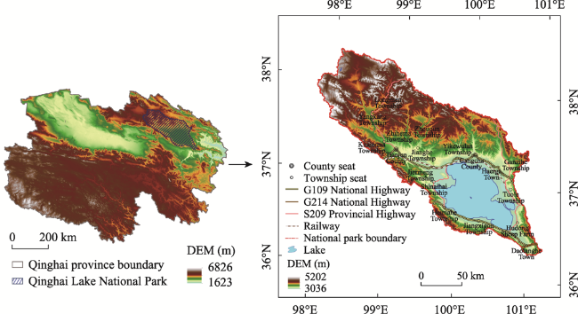
Figure 1 Geographic location of the study area (Qinghai Lake National Park)
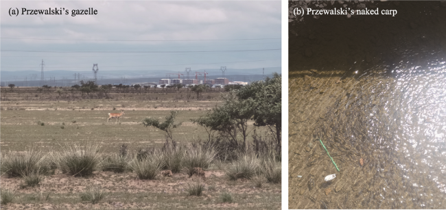
Figure 2 Flagship species in the Qinghai Lake National Park
Before the establishment of Qinghai Lake National Park, the scope of this study covers 6 subcategories of ecosystems and 8 natural protected areas, including existing natural reserves, scenic spots, wetland parks, geoparks, desert parks and aquatic germplasm resource reserves, which are managed by the Qinghai provincial government and forestry and agriculture departments. The total area of the park is 46,427.15 km2 (including overlapping protected areas). In addition, there is one international important wetland, namely, Bird Island, and one national important wetland, namely, Qinghai Lake, with a total area of 5124.81 km2 (including overlapping areas) (Table 1 and Figure 3) (Cheng et al., 2020; Liu et al., 2020). Both of these areas are managed by the forestry department. After the establishment of Qinghai Lake National Park, other types of nature reserves will not be retained within the scope. Most of the indigenous residents in Qinghai Lake National Park mainly rely on animal husbandry and natural resources in the park. There are 36,043 households in the area, with a population of 108,639 people and a population density of 3.66 people/km2.
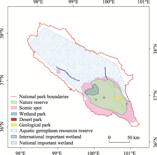
Table 1 Current status of the existing natural protected areas in Qinghai Lake National Park
Name County Level Approval time/ year Approved area (km2) Administrative department
in charge
Main protected
objects
Qinghai Lake National Nature Reserve Gangcha; Haiyan; Gonghe National level 1975 4588.81 Qinghai Lake Scenic Area Protection and Utilization Administration Lake wetland ecosystems such as Qinghai Lake and wetland around the lake, rare and endangered wild animals such as Przewalski’s gazelle and their habitats
Qinghai Lake Naked Carp National Aquatic Germplasm Resources Reserve Gangcha; Haiyan; Gonghe; Tianjun National level 2007 33,857 Department of Agriculture Qinghai Lake naked carp, ganzihe naked carp, hard spiny loach, stephensi loach, dorsal spotted loach and Longtou loach
Qinghai Lake National Scenic Spot Gangcha; Haiyan; Gonghe National level 1994 7577.84 Qinghai Lake Scenic Area Protection and Utilization Administration Qinghai Lake wetland ecosystem and migratory bird landscape, etc
Tianjun Mountain Provincial Scenic Spot Tianjun Provincial level 2013 90 Forestry
Department
Tianjun stone forest, Tianjun mountain and other natural landscapes and religious and cultural stone carvings and cultural landscapes
Qinghai Lake National Geopark Gangcha; Gonghe National level 2010 209.36 Qinghai Lake Scenic Area Protection and Utilization Administration Qinghai Lake plateau lake
Tianjun Buha River National Wetland Park Tianjun National level 2014 71.34 Forestry
Department
Swamp, river wetland ecosystem, rare and endangered waterfowl and their habitats
Shaliuhe National Wetland Park, Gangcha,
Qinghai
Gangcha National level 2016 29.81 Forestry
Department
Swamp, river wetland ecosystem, rare and endangered wild animals and their habitats
Ketu National Desert Park, Haiyan County, Qinghai Hanyan National level 2015 2.99 Forestry
Department
Alpine desert ecosystem and rare and endangered wild animals
Qinghai Lake Bird Island International Important Wetland Gangcha;
Gonghe
National level 1992 536 Forestry
Department
The wild animals inhabiting and breeding in Qinghai Lake, and the fragile plateau lake wetland ecosystem such as Qinghai Lake and its surrounding wetlands
Qinghai Lake National Important Wetland Gangcha; Haiyan; Gonghe National level 2011 4588.81 Forestry
Department
Waterfowl, birds, Qinghai Lake naked carp
Figure 3 Proposed spatial distribution of the existing natural protected areas in Qinghai Lake National Park

2.2 Data collection and processing

The data used in this study mainly include the following:
(1) The land use data for the Qinghai Lake Basin were derived from the vector data of the third land survey conducted by the Qinghai Provincial Department of Natural Resources. The land use types in the study area were classified and counted based on the land use status and land classifications of this survey.
(2) The elevation data (DEM) were obtained from the geospatial data cloud (http://www. gscloud. CN/). With a spatial resolution of 50 m×50 m, the elevation, slope, slope length, vegetation coverage and other data in the study area were analyzed.
(3) The net primary production (NPP) data of the vegetation were obtained by using the NPP mathematical model. The spatial analysis was carried out with GIS.
(4) The meteorological data were obtained from the Resource and Environmental Science and Data Center (www.resdc. CN) and mainly included annual rainfall and annual temperature data.
(5) The census data that included tourism resource points were obtained from the tourism census data of the Qinghai Provincial Department of Culture and Tourism.
(6) Population density, current population status, spatial distribution of natural protected areas, natural landscape, cultural landscape vector data and general data relevant to the administrative units were derived from the 2020 Qinghai Lake Basin Natural Resources and Socioeconomic Background Survey report and Qinghai Lake Ecotourism Planning Project.
(7) The spatial distribution data for the flagship species were provided by the Qinghai Lake Scenic Spot Protection and Utilization Administration of Qinghai Province.
In this study, the spatial data were projected uniformly. The database was constructed and resampled to a 50 m×50 m resolution grid.

2.3 Methods

2.3.1 Analysis of ecological protection importance

Analyzing the importance of ecological protection mainly involves assessing ecosystem service functions and ecosystem sensitivity. This importance analysis method has been used to determine the suitability of important natural ecosystems, rare and endangered wild animals and plants and their habitats, ecologically fragile areas and social service areas. This method can be used to guide functional zoning (Fu et al., 2017).
According to the eco-environmental characteristics of Qinghai Lake National Park, its ecosystems are divided into six subcategories: forest, wetland, grassland, water area, cultivated land and other ecosystems (Table 2). After the field investigation of the study area, the corresponding data were collected and processed with GIS and other software. Thus, a spatial attribute database was established. To accurately express the spatial differences in the study area, the 50 m×50 m grid was the basic evaluation unit used to construct the index system of ecosystem service function importance and ecological environmental sensitivity. Then, cluster merging and convergence analysis were carried out to identify the areas with high amounts of ecosystem service functions and ecologically sensitive and vulnerable areas to provide a basis for the functional zoning of national parks.
Table 2 Classification of ecosystem types
Terrestrial ecosystem type Surface cover type
Cultivated land Irrigated land and dry land
Forest Shrub woodland, arbor woodland and other woodlands
Grassland Natural grassland, artificial grassland and other grasslands
Aquatics River surface, pond surface, reservoir surface, river and lake
Wetland Inland beach and swamp
Others Construction land, various road pavements, other urban planning land, etc.
(1) Method of evaluating ecosystem service functions
Evaluating ecosystem service functions is helpful for determining the importance of these functions. This type of evaluation can provide a basis for determining ecological functions and protecting the ecological environment (Norton et al., 2015). According to the characteristics of the resources, environments and ecosystem types in Qinghai Lake National Park, the ecosystem service functions of the park were divided into five types: climate regulation, water conservation, water and soil conservation, biodiversity protection and social and cultural services (Lai et al., 2013; Fu et al., 2019). By using GIS software, the importance of each ecosystem service function was divided into four levels by the quantile method, and these levels were generally important, important, highly important and extremely important.
Climate regulation function importance: An evaluation index of the climate regulation service function in Qinghai Lake National Park was established (Table 3). According to the following calculation method, through the grid calculation in GIS software, temperature regulation (Formula 1) and humidity regulation (Formula 2) were calculated to obtain the climate regulation importance value (Formula 3). After normalization, the functional importance was divided to obtain the functional importance distribution map of the climate regulation service.
$E{{t}_{i}}=\frac{({{A}_{i}}\times {{E}_{i}}\times \rho \times {{H}_{e}})}{Q{}_{e}}\times {{P}_{c}}$
Table 3 Evaluation index of the climate regulation service function value of Qinghai Lake National Park
Ecosystem service Evaluating indicator Function category Evaluation method
Climate regulation Temperature adjustment Regulation service Energy substitution method
Humidity regulation Regulation service Cost substitution method
where Eti refers to the temperature regulation value of i class ecosystem (yuan/a); Ai is the area of i class ecosystem (m2); Ei represents the actual evaporation capacity per unit area of i class ecosystem (mm); ρ is the air density (kg/m3); He represents the vaporization heat of water (kJ/kg); Qc indicates the calorific value of standard coal (MJ/g); Pc is the price of standard coal (yuan/t) (considering the value of electricity consumption). To calculate the Eti value more accurately, the influence of altitude on water evapotranspiration must be considered. In this study, we used the vaporization temperature of water at 90°C as 2282.8 kJ/kg, and the air density was the annual average density of Qinghai Lake at 0.862 kg/m3.
$E{{m}_{i}}={{A}_{i}}\times {{E}_{i}}\times {{P}_{C}}$
where Emi is the humidity regulation value of a similar ecosystem (yuan/a) and Pc represents the cost of increasing the unit of humidity (yuan/m3). Ai and Ei are the same as above. In this study, Pc is calculated based on the power consumption of the humidifier. According to the normal power of 32 W, the power consumption of converting 1 m3 of water into steam is approximately 125 kW•h-1. The electricity price was calculated according to the electricity consumption value of local residents.
$Ec{{l}_{i}}=E{{t}_{i}}+E{{m}_{i}}$
where Ecli is the climate regulation value of the i type of ecosystem (yuan/a); Eti is the temperature regulation value of the i type of ecosystem (yuan/a); and Emi is the humidity regulation value of the i type of ecosystem (yuan/a).
Water conservation function importance: The water balance equation is widely used in large-scale water conservation calculations. Its main evaluation index is water conservation. The Formula (4) is as follows:
$TQ=\sum\nolimits_{i=1}^{j}{({{P}_{i}}-{{R}_{i}}-{{E}_{i}})\times {{A}_{i}}\times {{10}^{3}}}$
where TQ is the total amount of water conservation (m3), Pi is the annual average rainfall (mm), Ri is the surface runoff (mm), Ei is the evapotranspiration (mm), Ai is the area of the first ecological type (km2), i is the ecological type, and j is the number of ecological types.
Among the variables, surface runoff is the amount of precipitation or snow melting. Once infiltration intensity is exceeded, the excess water cannot infiltrate and will be temporarily retained on the surface. When the surface storage reaches a certain limit, the water will flow to a lower position and become surface water, which will converge with streams. The surface runoff was calculated according to the runoff conversion formula in the water balance equation. The Formula (5) is as follows:
$R=P\times \alpha $
where R is the surface runoff (mm), P is the average annual precipitation (mm), and α is the average surface runoff coefficient.
Water and soil conservation importance: The water and soil conservation ecosystem service model was the modified general water and soil loss equation (RUSLE), and it was used for the evaluation. The Formula (6) is as follows:
${{A}_{C}}={{A}_{p}}-{{A}_{r}}=R\times K\times L\times S\times (1-C)$
where AC is the amount of water and soil conserved (t/hm2a); Ap is the potential amount of soil erosion; Ar is the actual amount of soil erosion; R is the rainfall erosivity factor (MJ•mm/hm2h); K is the soil erodibility factor (t•hm2h/hm2MJ•mm); and L and S are terrain factors. L represents the slope length factor, S represents the slope factor, and C is the vegetation coverage factor.
Biodiversity importance: Four factors, namely, the distributions of biological species, endemic species, and protected species and ecosystem type, were used as biodiversity evaluation indicators (BD) of Qinghai Lake National Park by taking into account the ecological environmental characteristics of the park (Figure 4).
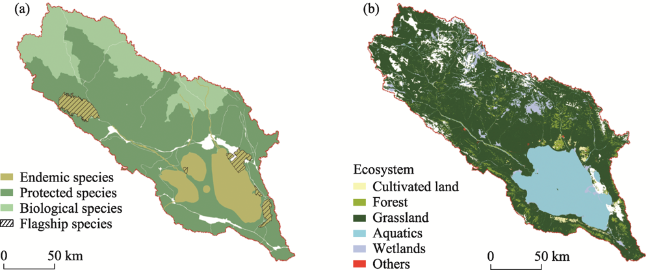
Figure 4 Spatial distribution of biodiversity evaluation indicators of Qinghai Lake National Park: (a) Species distribution; (b) Ecosystem type distribution
The weight of each evaluation index is determined by expert consultation method, calculated by Yaahp software and combined with existing literature research (Wan et al., 2007). Among the factors, species distribution mainly reflects species richness, the highest protection level of species is usually used for analysis. Ecosystem type reflects the suitability habitats of different ecological types and land cover types for species. Their weights are set as follows: aquatic ecosystem 0.08; wetland ecosystem and forest ecosystem 0.04; grassland
ecosystem 0.02; cultivated land ecosystem and other ecosystems 0.01. The calculation method is shown in Formula (7):
$BD=\sum\nolimits_{i=1}^{j}{B{{I}_{i}}\times {{W}_{i}}}$
where BIi is the biodiversity evaluation factor, i is the parameter category, and Wi is the weight of four factors, which are set as 0.1, 0.5, 0.2 and 0.2 in turn.
Social and cultural function importance: Using the GIS platform, the distribution map of tourist areas in the relevant states and counties was constructed, the distribution of traffic and urban areas was used to determine the buffer of the tourist areas, and buffer analysis was conducted to obtain the regional distribution map of tourist spots. Then, the ecosystem type distribution map for Qinghai Lake Basin was used as the classification factor to obtain the importance map of the social and cultural service functions of the Qinghai Lake National Park ecosystem by fuzzy superposition analysis of the tourism point radiation area map and ecological type map.
(2) Ecosystem sensitivity assessment
Ecologically sensitive areas are areas where ecological elements and the overall ecological environment play an important and decisive role in the ecological environment (Yin et al., 2014). Twelve single-factor indicators, such as geomorphic slope, annual temperature and precipitation, rivers and lakes, vegetation coverage, NPP and biodiversity, were selected to establish the ecological sensitivity index for Qinghai Lake National Park (Tables 4 and 5) (Pan et al., 2012; An and Shen, 2013; SCPRC, 2017).
Table 4 The ecologically sensitive natural factors affecting Qinghai Lake National Park
Grading 1 2 3 4 5
Topographic features Geomorphology Middle altitude plain, low altitude platform, low altitude hill High altitude plain and mid altitude hilly area Small ups and downs, low mountains and high-altitude platforms Middle undulating mid-mountain High altitude hills and high altitude plains
Altitude (m) <2372 2372-2765 2765-3082 3082-33,691 3369-36,718
Slope (°) <5 5-10 10-15 15-19 19-24
Climate
and
hydrology
Air temperature (℃) 20-28 15-20 5-10 0-5 -8-0
Precipitation (mm) 4000-4437 3700-4000 3400-3700 3000-3400 2800-3000
River Distance from river - Build a buffer zone 7-10 km away from the river center line - A 5-7 km buffer zone will be built from the river center line
≥10 km
Lake Distance from lake - Establish a buffer zone 15-20 km away from the lake - Establish a buffer zone 10-15 km away from the lake
>20 km
Vegetation conditions Vegetation type Temperate deciduous shrub, subalpine
deciduous broad-leaved shrub, and temperate tufted grass typical grassland
Cold temperate and temperate mountain coniferous forest, subalpine evergreen coniferous shrub Cold temperate zone / temperate swamp, temperate grass / miscellaneous grass halophytic meadow, Alpine Kobresia / miscellaneous grass meadow Once a year crop, short growth period cold tolerant crops (no fruit trees), alpine grass/Carex grassland Temperate semi-shrub, dwarf semi- shrub desert
Vegetation coverage (km2) >6500 5000-6500 4100-6500 3000-4100 1500-3000
Net primary productivity of vegetation (g·m‒2·a‒1) >337 271-377 217-271 167-217 124-167
Soil
condition
Soil type - Chernozem, light chernozem, chestnut soil, black felt soil, brown black felt soil, and wet black felt soil Meadow chestnut soil, swamp soil, meadow swamp soil and black felt soil Glebe meadow soil, sapropel swamp soil Calcareous meadow soil, grass felt soil
Brown grass felt soil
Bio-
diversity
Bio-diversity - - - - -
Grading 6 7 8 9
Topographic features Geomorphology Extremely high altitude tableland, extremely high altitude hills and small undulating mid-mountains Small undulating high mountain, medium undulating low mountain and medium undulating high mountain Small undulating extremely high mountain, large undulating
middle mountain and large undulating high mountain
Medium
undulating extremely high mountain and large undulating extremely high mountain
Altitude (m) 3671-3943 3943-4215 4215-4517 >4517
Slope (°) 24-28 28-32 32-37 >37
Grading 6 7 8 9
Climate
and
hydrology
Air temperature (℃) -8- -15 -15- -20 -20- -30 <-30
Precipitation (mm) 2600-2800 2500-2600 2400-2500 2344-2400
Rivers - Establish a 2-5 km buffer zone from the river centerline - Establish a 0-2 km buffer zone from the river centerline
Lake - A 5-10 km buffer zone shall be established from the lake. - Build a buffer zone 0-5 km away from the lake
Vegetation conditions Vegetation type Alpine sparse vegetation, alpine cushion dwarf semi-shrub desert Others (impervious surface) - -
Vegetation coverage (km2) 500-1500 400-500 150-400 <150
Net primary productivity of vegetation (g·m‒2·a‒1) 87-124 54-87 23.9-54 <23.9
Soil
condition
Soil type Alluvial soil Light cold
calcium soil, grassland aeolian sand soil
Cold calcium soil, stone soil Calcareous rocky soil, alkaline saline soil, cold frozen soil
Bio-
diversity
Bio-diversity Experimental area of the Qinghai Lake National Nature Reserve Qinghai Lake National Nature Reserve, buffer zone and Tianjun Mountain Provincial Scenic Spot Gangchashaliuhe National Wetland Park and Tianjun Buha River
National
Wetland Park
Core area of the Qinghai Lake National Nature Reserve and important habitat of Przewalski’s gazelle
Table 5 Classification of the ecological sensitivity single-factor evaluation system for Qinghai Lake National Park
Ecological sensitivity factor Insensitive
area
Slightly
sensitive area
Moderately
sensitive area
Highly sensitive area Extremely
sensitive area
Geomorphic type 1 2, 3, 4 5 6, 7 8, 9
Altitude 1, 2, 3 4, 5 6 7 8, 9
Slope 1 2, 3 4, 5 6, 7 8, 9
Air temperature 1, 2 3, 4 5, 6 7, 8 9
Precipitation 1, 2 3 4, 5 6, 7 8, 9
River 1 2, 3 4, 5 6, 7 8, 9
Lake 1 2, 3 4, 5 6, 7 8, 9
Vegetation type 1, 2 3, 4, 5 6, 7 8 9
Vegetation coverage 1, 2, 3 4, 5 6, 7 9 9
Net primary productivity of vegetation 1 2 3, 4, 5 6, 7 8, 9
Soil type 1, 2 3 4, 5 6, 7 8, 9
Biodiversity 1 2, 3 4 5 6
The system mainly includes 1 target layer (A), 5 criterion layers (B) and 12 measure layers (C). The factor importance of each measure layer is expressed according to the “1-9 scale method”. According to the importance of single factor, different weights are given by using scientific methods such as analytic hierarchy process, dominant factor method and Delphi method in combination with existing research (Sun et al., 2020). Finally, the spatial distribution results for comprehensive ecological sensitivity were obtained through a multifactor, decentralized weight, spatial superposition analysis to identify highly sensitive areas that were not easy to recover after interference. Ecologically sensitive areas were divided into five levels: an extremely sensitive area, highly sensitive area, moderately sensitive area, slightly sensitive area and insensitive area. The results of the evaluation reflected the sensitivity degree and spatial distribution characteristics of the ecological environment in the study area.

2.3.2 Multifactor trade-off functional zoning process

The multi factor trade-off functional zoning carries out the preliminary identification of spatial delimitation based on the evaluation of multiple ecological indicators and distinguishes the gradient level of ecological importance spatial pattern. Meanwhile, this functional zoning combines the trade-off decision-making process such as management and control requirements and management feasibility, that is, the multi-type, multi-level and multi-scale factor comprehensive trade-off of the two systems of natural attributes and social attributes.
The path of multi factor trade-off functional zoning is shown in Figure 5. The specific process is listed as follows: 1) We focus on the assessment of the importance of ecological protection in the region, determine the types of key ecosystem service functions and key sensitive factors that need to be assessed and analyzed, and build an assessment index system. 2) Based on the results, important ecosystem service functional areas and ecologically sensitive areas are divided. And combined with the interference degree of human activities to the National Park and flagship species, the spatial distribution of habitat is analyzed by GIS weighted superposition. 3) We define the management and control objectives of National Park functional zoning according to the core concept and core value of national park construction. 4) Through multi factor trade-off matrix analysis, the functional zoning scheme is determined.
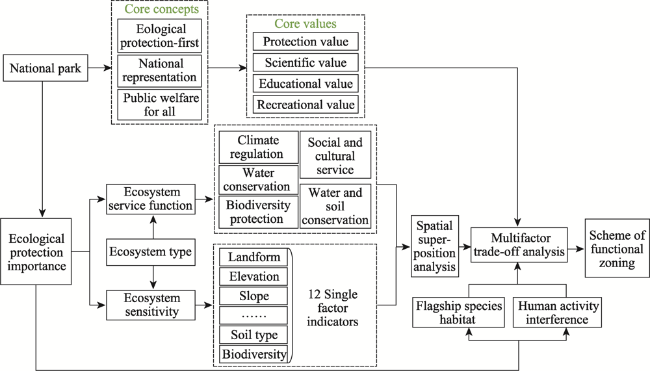
Figure 5 Technical method for functional zoning in Qinghai Lake National Park

3 Results

3.1 Results from the evaluation of the importance of ecosystem service functions

Through the division of functional importance values after normalization in GIS software, a distribution map of the ecosystem service functional importance values for Qinghai Lake National Park was obtained, as shown in Figure 6. Figure 6 shows that the ecosystem types in Qinghai Lake National Park play a very important role in climate regulation services. The area with extremely important climate regulation functions accounts for 39% of the overall area, and the area with highly important climate regulation functions accounts for 16% of the overall area; thus, both areas account for 55% of the park or more than half of the total area of the park. The water conservation function is strong, with the area having extremely important water conservation functions accounting for 20.3% of the overall area and the highly important area accounting for 22% of the overall area; thus, both areas account for 42.3% of the park or close to half of the total area of Qinghai Lake National Park. The overall soil and water conservation function is weak, and the areas with important and generally important soil and water conservation functions account for 45.4% and 34.8% of the overall area, respectively, while the extremely important soil and water conservation area accounts for only 3.3% of the overall area. The biodiversity protection function is very good, mainly occurring at the highly important level in 30.44% of the park, while the extremely important level of biodiversity protection accounts for 26.98% of the overall area; thus, the two areas account for 57.42% of the park. The biodiversity protection service function is strong. The social and cultural service function occurs mainly at the extremely important level in 45.67% of the park. The area of high importance accounts for 16.47%, and the overall proportion of these two areas reaches 62.14%, indicating that the social and cultural service function of Qinghai Lake National Park has a high value. In general, the dominant ecosys-ctem service functions in the study area are social and cultural service functions and biodiversity protection service functions. The order of importance of the ecosystem service functions of Qinghai Lake National Park is social and cultural service function > biodiversity protection service function > climate regulation service function > water conservation service function > water and soil conservation service function.
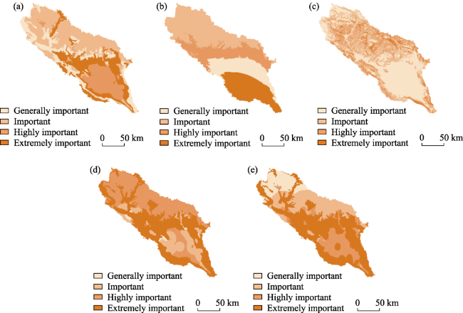
Figure 6 Analysis of the importance of the ecosystem service functions of Qinghai Lake National Park: (a) importance of the climate regulation function, (b) importance of the water conservation function, (c) importance of the water and soil conservation function, (d) importance of the biodiversity protection function, and (e) importance of the social and cultural service function
Based on the standard normalization of five types of ecosystem service functions, the weight of different layers is determined by entropy method. Then the spatial weighted superposition analysis is carried out through GIS special analyst tool according to the weight results, we obtained Figures 7 and 8, and from these figures, it can be seen that the important types of integrated ecosystem service functions in the study area are mainly at the important level and occur in an area of approximately 11,998 km2, accounting for 40.45% of the total area of the park. This area is mainly concentrated around Qinghai Lake and rivers. There are many natural ecosystems, such as mountains, rivers, forests, fields, lakes, grass, sand and ice, and wetland ecosystems; Yangkangqu and Hilgequ are in northwestern Tianjun County on the top of the mountain. Western Yangkang township, Tianjun County, and other areas are generally important areas with minimal ecosystem service functions. These areas cover approximately 8,136 km2, accounting for 27.43% of the total area of the park. This region has minimal social and cultural service functions, a low degree of human interference, and a good ecological environment.
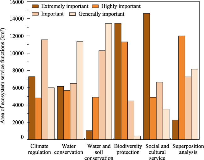
Figure 7 Structural characteristics of various important types of ecosystem service functions in Qinghai Lake National Park
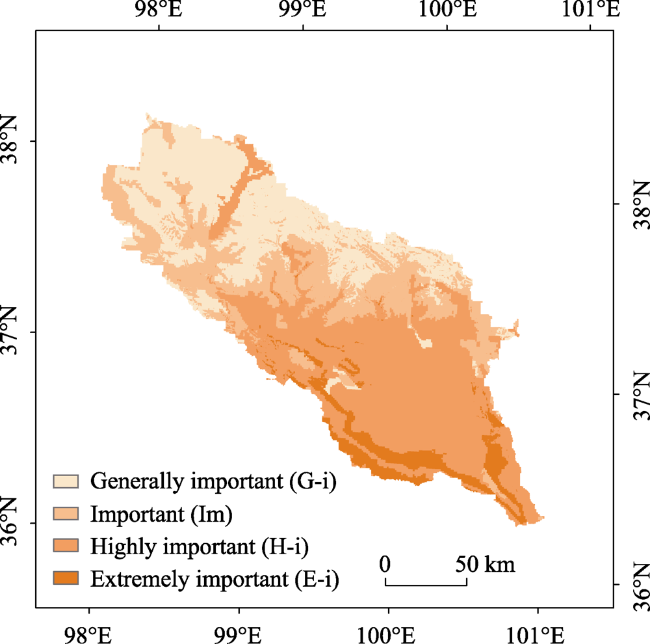
Figure 8 Superimposed analysis diagram of the ecosystem service function importance values in Qinghai Lake National Park

3.2 Results of the ecological sensitivity evaluation

The results of the ecological sensitivity evaluation for Qinghai Lake National Park were calculated by GIS software, as shown in Figure 9. The results show that the extremely sensitive areas are distributed in the park in areas with low vegetation coverage, high elevations, and steep slopes and in the upper reaches of rivers and lakes, mainly on the northeastern edge of Qinghai Lake because Qinghai Lake Basin has a special environment. Its hydraulic erosion, wind erosion and soil erosion coexist alternately as this area is vulnerable to hydraulic erosion and soil erosion. It can be seen that the periphery of Qinghai Lake is very sensitive to the reduction of rainfall from (Figures 9d, 9e and Tables 4-5). However, it is not sensitive to consider only from the single lower temperature. Due to the staggered distribution of sensitive areas at all levels, once the extremely sensitive areas and highly sensitive areas are damaged by nature or man-made, the recovery speed and degree will be slow. Additionally, the ecosystem function of the area will also be reduced.
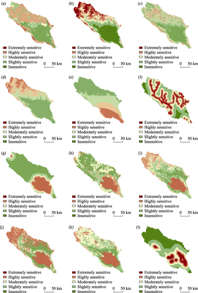
Figure 9 Ecological sensitivity analysis of Qinghai Lake National Park: (a) landform, (b) elevation, (c) slope, (d) temperature, (e) precipitation, (f) river, (g) lake, (h) vegetation type, (i) vegetation coverage, (j) NPP, (k) soil type, and (l) biodiversity
The highly sensitive area is small and concentrated. Slightly sensitive areas and insensitive areas account for a large proportion of Qinghai Lake National Park. Slightly sensitive areas were mainly distributed in areas with high vegetation coverage, high altitudes and low levels of human activity. Natural sensitivity induces and plays an important role in the development of ecoenvironmental sensitivity in Qinghai Lake National Park. Soil and land use types are sensitive to ecology. In the area around the lake, the higher the land use rate is, the higher the ecological sensitivity. The ecological sensitivity of other areas is generally positively correlated with vegetation cover, soil type and altitude gradient.
Based on the standard normalization of 12 single factor ecological sensitivities, the weight of different layers is determined by entropy method. Then the spatial weighted superposition analysis is carried out through GIS special analyst tool according to the weight results, Figures 10 and 11 shows that the sensitive ecosystem areas in the study area are evenly distributed. The extremely sensitive and highly sensitive areas account for 32.25% of Qinghai Lake National Park, and this area is suitable for ecological protection. These areas mainly include Qinghai Lake, which occurs in central and northern Shaliuhe town and Hargai town in Gangcha County, northern Zhihema township, northern Suli township, northwestern Longmen Township, and central-western Yangkang Township in Tianjun County. In other towns, the areas suitable for ecological protection are scattered. In the area with a high elevation, a low temperature and high vegetation coverage is the main habitat for Huangyu and waterfowl.
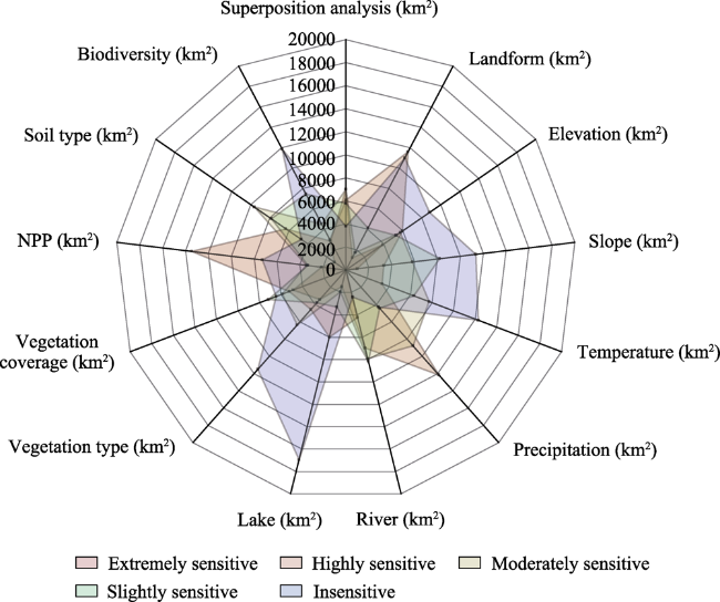
Figure 10 Structural characteristics of the ecological sensitivity of Qinghai Lake National Park
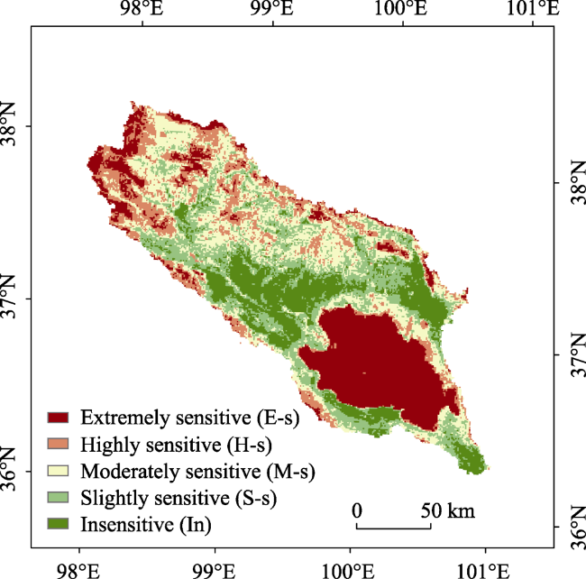
Figure 11 Superposition analysis of the ecological sensitivity of Qinghai Lake National Park
In comparison to the other areas, the moderately sensitive area accounts for 23.61% of Qinghai Lake National Park and is more suitable for the protection and restoration of natural ecosystems and scientific research and monitoring and other activities. This moderately sensitive area is mainly distributed incentral Jilmeng township, Quanji township, central and western Ikulan Township in Gangcha County, northern Zhihema township in Tianjun County and central Tole township in Haiyan County. In other towns around and in high-elevation areas, moderately sensitive areas are scattered. The slightly sensitive area and insensitive area account for 44.14% of Qinghai Lake National Park.

3.3 Results of the evaluation of human activity interference

At present, there are few national park ecosystems that are not affected by humans. Human activities in and around national parks often threaten their ecological security patterns. In some cases, although national parks are protected, they still lead to the decline of ecosystems (Wan et al., 2015; Han et al., 2020). Based on the actual situation of the study area, the human activity interference indicators that have a great impact on the ecosystem of Qinghai Lake National Park, namely, land use type, population level, transportation, industry, animal husbandry and other indicators, were selected to construct the human activity interference index, as shown in Figure 12. Then, the grid data of human activity interference indicators were processed in GIS. Because different human activity interference indicators have dif ferent dimensions, it was necessary to normalize each indicator layer and then determine the weight of different layers by the entropy weight method. Finally, the human interference index was obtained by superposition according to the weight results (Zhou et al., 2021).
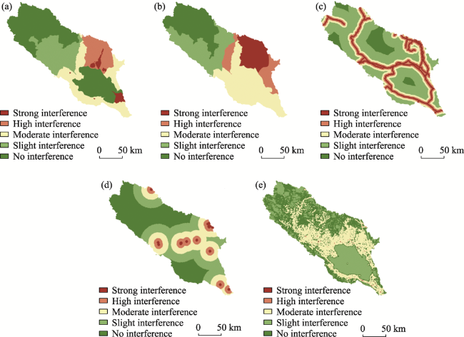
Figure 12 Analysis of the interference degree of human activities in Qinghai Lake National Park: (a) population, (b) animal husbandry, (c) transportation, (d) industry, and (e) land use
Overall, the intensity of human intervention in Qinghai Lake National Park is low, as shown in Figures 13 and 14. Areas with no interference and slight interference account for 61.14% of the park. They are distributed in the northwestern part of the basin, indicating that there are few human activities in this area. Generally, human impacts on ecosystem security in this area are low. The area with strong human activity interference accounts for only 6.23% of the park, but the distribution of human activity is dense, especially in Tianjun County, Gangcha County and Bird Island. Although the area of intense population expansion accounts for a relatively small proportion of the park, the ecosystem security of this area is greatly affected by human activities. Therefore, ecological environmental protection in this region is particularly important.
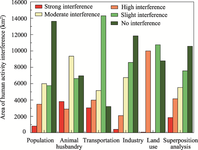
Figure 13 Structural characteristics of various types of human activity interferences in Qinghai Lake National Park
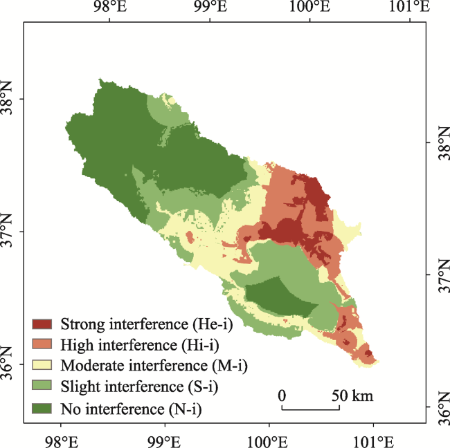
Figure 14 Superposition analysis of the degree of human activity interference in Qinghai Lake National Park

3.4 Functional zoning scheme

3.4.1 Partition of functional areas

Based on the above assessment results on the importance of ecological protection and the interference degree of human activities, a multifactor trade-off matrix analysis was conducted to determine key protection objectives, as shown in Figure 15. At the same time, this analysis is fully compatible with the needs of scientific research and monitoring, ecotourism, and popular science education and indigenous daily life and production needs to facilitate the feasible long-term planning and management of the national park, reduce the need for follow-up management and enhance the public welfare for all people. Thus, Qinghai Lake National Park was divided into five functional areas, as shown in Figure 16.
Figure 15 Multifactor trade-off matrix of the functional zones of Qinghai Lake National Park
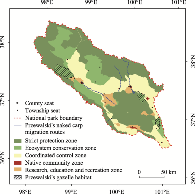
Figure 16 Functional zone of Qinghai Lake National Park

3.4.2 Zone characteristics and control requirements

(1) The strict protection zone has an area of 15,038.93 km2. It protects complete natural ecological geographic units, such as the original forest ecosystem and alpine meadow ecosystem. This zone also maintains the complex ecosystem function of the basin, ensures a smooth migration channel for naked carp at the source of Qinghai Lake, and promotes the connectivity of and quality improvements in important habitats of wild animals such as Przewalski’s gazelle and waterfowl. Thus, the sustainable development of the Qinghai Lake water supply and water quality are guaranteed. The upstream water conservation function and the stability, legitimacy and integrity of the water cycle in the basin will not be affected in this zone. Development, construction and human activities are strictly prohibited in this area. Upon approval, activities such as protection and law enforcement, management and patrols, resource investigation and monitoring, disaster prevention and control, restoration of farmland to forest or grassland, ecological corridor construction, scientific research, monitoring and protection facilities, and construction of major ecological protection and restoration projects can be carried out.
(2) The ecosystem conservation zone has an area of 6277.21 km2 and contains important and fragile ecosystems. It is necessary to restore the degraded natural ecosystem in this area, maintain the wildlife habitat under national key protection programs, and isolate or decrease the interference of the outside world in strict protection zones. This area enables naturally occurring restoration, which is supplemented by artificial measures if necessary. In principle, human activities are limited in this area. Through necessary ecological measures, the areas that are damaged to varying degrees and need to be restored are repaired to maintain the integrity of theses habitats and ecosystems and ensure the connectivity of ecological corridors.
(3) The coordinated control zone has an area of 6923.48 km2. In this area, there are natural and human resources. It is an area where long-term research and regular observations can be carried out to isolate or decrease the interference of science, education and recreation with ecosystem conservation zones. On the premise of regional ecological stability, this zone can be constructed where long-term research and regular observations can be carried out under certain constraints to reasonably develop ecological organic resources, further reduce pressure on grasslands that have livestock, increase the rate of converting herdsmen to other industries, and gradually reduce human activities. According to future ecological spatial changes, the spatial scope of this functional zone can be adjusted in a timely manner.
(4) The native community zone covers an area of 131.13 km2. This area has good pastures and relatively sustainable urban construction and infrastructure. This zone mainly provides production and living space for the indigenous people. This zone can also provide accommodations, restaurants and other business services for tourists. In principle, utilization of the area is limited. To ensure the basic living needs of the indigenous people, the urban and rural construction land is strictly controlled according to the overall land use plan.
(5) The research, education and recreation zone has an area of 1290.25 km2 and is relatively rich in natural and cultural resources. It is a gathering place for visitors to experience Qinghai Lake, Bird Island, Sand Island, Fairy Bay Wetland and Atomic City. This area has good recreational resources, a cultural landscape and a pleasant environment and is convenient enjoying natural experiences, ecotourism, rest, rehabilitation and other activities. It is a concentrated scenic area of Qinghai Lake National Park and an international ecotourism destination. In principle, this area is moderately utilized, and facilities can be constructed consistent with ecological environmental protection. It is the main area for ecotourism activities where popular science education, ecological experiences, ecological research summer camps, social practices, outdoor sports, cultural experiences and other activities can be carried out.
The characteristics and control requirements of each zone are described in Table 6.
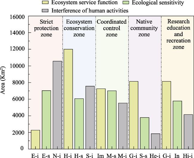
Table 6 Functional zones of Qinghai Lake National Park
Functional partition type Area (km2) Proportion (%) Number of areas Protection objectives and control requirements
Strict protection zone 15038.93 50.70 6 The most stringent protection to maintain the authenticity and integrity of the natural process of the ecosystem, and prohibit development, construction and human activities.
Ecosystem conservation zone 6277.21 21.16 7 Strictly protect to increase wetland diversity, protect flagship species habitat, and protect wildlife activities and feeding areas. In principle, human activities shall be restricted, the mining of key wild plants shall be prohibited, and appropriate watershed ecosystem and other related research shall be carried out.
Coordinated control zone 6923.48 23.34 2 Moderately protect to control and repair grass (wet) land, curb wetland shrinkage, increase the coverage of natural wetland grassland, and control water and soil loss. Areas where long-term research and regular observation can be carried out under certain constraints on the premise of regional ecological stability.
Native community zone 131.13 0.44 18 General protection, restricted use. Optimize the industrial structure and the structure of livestock breeds and herds. Animal husbandry shall be determined by grass, seasonal rest grazing and regional rotational grazing to realize the balance between grass and livestock. Ensure the basic living needs of indigenous residents.
Research education and recreation zone 1290.25 4.35 6 General protection and moderate utilization. Carry out moderately popular science education, ecological experience, recreation and sightseeing, health care and other activities. Carry out the undertakings of "national sports" and "plateau sports". The development and construction of industrialization and urbanization are prohibited.

4 Discussion

4.1 Determination of the main protection objects in the national park according to local conditions in the functional zoning

Our research results show that under the new policy of nature reserve system with national parks as the main body, Qinghai Lake National Park breaks the previous zoning model based on the three-circle structure proposed by the United Nations Educational Scientific and Cultural Organization and the traditional zoning model adopted by many national parks. It also breaks the functional zoning that only limits the pressure and threat of human activities (Katharina et al., 2018).
The national park is a new type of nature reserve in China. Its primary function is to protect a large area of natural ecosystem and flagship species, taking into account the comprehensive functions of scientific research, education, recreation and so on. In previous studies, most of them were set up to protect species habitats or suitable habitats (Leroux et al., 2010). However, our research is more to weigh what should be the key protection of national parks, to determine the key protection objects, and to use space through field investigation and discussion visits, data analysis and communication with the competent department of national parks. Therefore, quantitative analysis of ecosystem service function and ecological sensitivity, human activity interference and other factors in a certain period before the establishment of the National Park as well as qualitative analysis of management and control requirements and management feasibility are the key to realize the landing of functional zoning with the function of the National Park as the goal. Of course, due to the availability of some data, more indicators to analyze trade-offs need to be further studied.

4.2 Coordination of protection and utilization in functional zones

National parks are the most visible, natural education platforms and are extremely valuable naturally occurring scientific research bases. They have the dual tasks of protecting and utilizing natural and cultural resources (Zhang et al., 2018). The functional zoning of National Parks is a means to achieve both ecological protection and rational utilization of resources. However, in specific practice, due to the lack of standard technical specifications and appropriate evaluation methods, the subjectivity of functional zoning is often very strong. Therefore, it is necessary to establish an index system to determine the basis of zoning. The system not only pays attention to the importance and utility of ecological protection (Shadie et al., 2013), but can also meet the needs of production, life and development. In addition, it can guide the land use of national parks towards differentiated management and control and formulate corresponding management objectives.
In practice, for example, constructing new buildings in a strict protection zone is strictly prohibited. All production and business activities and building (structure) expansions are also prohibited. Recreational sightseeing, scientific research monitoring, ecological experiences and other activities can be carried out in the ecosystem conservation zone and native community zone. A traditional utilization area can be reconstructed at the original site after approval. This approach will help address the conflict inherent in coordinating the protection and utilization of national parks, facilitate zoning control and establish control measures, which cannot be ignored in delineating the functional zones of national parks.

4.3 Dynamic changes in the ecological environment in functional zones

Functional zoning is based on the concept that mountains, rivers, forests, fields, lakes, grass, sand and ice are biological communities that promote the healthy development of national park ecosystems (Zhang et al., 2018; Wang et al., 2020). To adapt to dynamic factors, such as water level increases and decreases, wetland spatial changes, desertification, grassland degradation and human disturbances, mainly caused by climate change, in the Qinghai Lake Basin, a coordinated control zone was set up as a functional zone to address future ecological spatial changes. National parks are dynamic spatial systems and can be considered a whole system. Zoning is implemented to control the spatial system of a park and ensure its spatial structure and functions evolve toward the development goal of ensuring ecological security and enhancing national involvement.
National park functional zoning is a dynamic process of constantly identifying and addressing new problems. After the functional zoning scheme is determined, it may only be applicable for a certain period of time, so it is necessary to monitor and evaluate the system. The zoning scheme should be adjusted and optimized in a timely manner in accordance with the succession and change in biodiversity in a national park at different stages and improvements in the surrounding ecological environment, and this approach is in line with the principle of continuously strengthening protection. This dynamic adjustment to zoning is also a positive and effective response to the inability to fully and accurately predict future ecological environmental changes.

4.4 Essential attributes of protection value and comprehensive functions in functional zones

In China, the primary function of national parks is to protect the legitimacy and integrity of important ecosystems. The comprehensive function of national parks is the scientific protection and appropriate utilization of spatial resources such as natural relics and natural landscapes with scientific research, educational, cultural and recreational values (Liu et al., 2020). If the function of a national park is compared to a coin, then the front is the primary function, and the other side is science, education and recreation. China's national park system essentially sets the functional scope of national parks from the two dimensions of protection value and comprehensive function. Overall, national parks should have at least four types of functional roles: protection, science, education and recreation. However, each functional zone in a national park does not have the above four functions at the same time.
In the process of determining the boundaries of functional zones, each functional zone should be considered an interrelated and interdependent whole so that the spatial layout can be reasonably determined and divided, while also considering the feasibility of natural resource management, structure management, protection management foundations and the potential for national involvement in national parks; in addition, providing convenient experience while also considering governance types, such as social governance, public welfare governance and common governance is important. It is often difficult to determine the boundary of a functional zone. For example, a boundary based on biological pattern characteristics and processes may be inconsistent with a boundary based on hydrological and aquatic ecological processes. To formulate a functional zoning plan for a national park, the focus should be place on performance characteristics and effectiveness of important ecological protection measures within the spatial area of the functional zone of the national park. In addition, attention should be given to leading and guiding the concepts, ideas and spirit of planning the main functional zones of land and space.

5 Conclusions

A national park is a complex ecosystem. The delimitation of functional zones requires an investigation and analysis of the characteristics of the spatial natural resources of the park, comprehensive research and assessments, and systematic planning according to local conditions. In this study, geospatial data and GIS were used to evaluate the importance of ecological protection; identify the importance values of ecosystem services and their corresponding areas and ecologically sensitive areas in the region; weight the interference degree of human activities; determine the spatial patterns of flagship species and their habitats, scientific research monitoring and ecotourism; and implement functional zoning. The main conclusions drawn are as follows:
(1) Qinghai Lake National Park is an extremely valuable natural landscape where mountains, rivers, forests, fields, lakes, grass, sand and ice coexist. More than 80% of the area has high natural integrity and ecological connectivity, suitable material and energy flows and biological diffusion and complete ecological processes. Due to the special environment of Qinghai Lake National Park, ecologically sensitive areas account for only 12.77% of the national park and consist mainly of the Qinghai Lake wetland ecosystem and the forest ecosystem that is above 4000 meters above sea level; in addition, hydraulic erosion, wind erosion and soil erosion coexist alternately. In comparison to other areas in the park, these sensitive areas are more vulnerable to hydraulic erosion and soil erosion where there is low vegetation coverage, high altitude slopes and the upper reaches of lakes and rivers. However, the regional ecosystem pattern is stable, and the overall ecological environment is improving and providing more comprehensive ecosystem service functions. In the Qinghai Lake Basin, to prevent the increase and decrease of water levels caused by global climate change and the interference pressure of human activities caused by the area being an international ecotourism destination, the protection of Qinghai Lake and the wetland ecosystems are the key factors that need to be focused on to maintain the regional ecological security pattern and the integrity and legitimacy of ecosystems.
(2) Taking the importance of ecological protection as the premise, the multifactor trade-off zoning process not only accounts for the primary function of a national park but also better balances the contradictory relationship between protection and development and improves the imbalance in emphasizing protection and neglecting development as occurs when zoning with single-resource protection as the goal or main protection object. This process changes the static pattern of functional zoning and reflects the dynamic characteristics of the human-land relationship by establishing a "dynamic zone". Through multifactor weighting, Qinghai Lake National Park was divided into five functional zones: strict protection zone, ecosystem conservation zone, coordinated control zone, native community zone and research, education and recreation zone, with zone proportions of 50.70%, 21.16%, 23.34%, 0.44% and 4.35%, respectively. According to the primary functions of the different zones, ecological, daily life and production activities can be carried out. Corresponding approval and restriction control requirements are suggested to maximize the overall utility of the protection value and comprehensive functions of the park. This research is conducive to enriching the basic theories and technical methods of national park functional zoning. The results provide a practical reference for spatial functional zoning methods for national land parks, nature reserves and other natural protected areas and can also serve as a reference for the protection of ecologically fragile areas in national parks and the sustainable utilization of resources.
[1]
Adams V M, Iacona G D, Possingham H P, 2019. Weighing the benefits of expanding protected areas versus managing existing ones. Nature Sustainability, 2(5): 404-411.

DOI

[2]
An C, Shen Q, 2013. Method of constructing network of green infrastructure based on ecological performance of space utilization. Landscape Architecture, 50(2): 22-32. (in Chinese)

[3]
Cao W, Wu D, Huang L et al., 2020. Spatial and temporal variations and signifcance identifcation of ecosystem services in the Sanjiangyuan National Park, China. Scientific Reports, 10: 6151.

DOI

[4]
Chen Z J, Wang L, Wei A S et al., 2019. Land-use change from arable lands to orchards reduced soil erosion and increased nutrient loss in a small catchment. Science of The Total Environment, 648: 1097-1104.

DOI

[5]
Cheng Q, Cheng X, Ma K X et al., 2020. Offering the win-win solutions between ecological conservation and livelihood development: National parks in Qinghai. Geography and Sustainability, 1(4): 251-255.

DOI

[6]
Craigie I D, Baillie J E M, Balmford A et al., 2010. Large mammal population declines in Africa’s protected areas. Biological Conservation, 143(9): 2221-2228.

DOI

[7]
Deng R, Shao H Y, Huang B R et al., 2021. Remote assessment on ecosystem integrity of the Qinghai-Tibet Plateau and research on National Parks Group construction sequence. Acta Ecologica Sinica, 41(3): 847-860. (in Chinese)

[8]
Domingo D, Palka G, Hersperger A M, 2021. Effect of zoning plans on urban land-use change: A multi-scenario simulation for supporting sustainable urban growth. Sustainable Cities and Society, 69: 102833.

DOI

[9]
Dudley N, 2008. Guidelines for Applying Protected Area Management Categories. Switzerland: Iucn.

[10]
Fan J, Zhong L S, Huang B R et al., 2019. Territorial function and feasibility of the Earth’s Third Pole National Park Cluster. Chinese Science Bulletin, 64(27): 2938-2948. (in Chinese)

[11]
Fu M D, Tian J L, Ren Y H et al., 2019. Functional zoning and space management of Three-River-Source National Park. Journal of Geographical Sciences, 29(12): 2069-2084.

DOI

[12]
Geldmann J, Barnes M, Coad L et al., 2013. Effectiveness of terrestrial protected areas in reducing habitat loss and population declines. Biological Conservation, 161(3): 230-238.

DOI

[13]
Geneletti D, Van D I, 2008. Protected area zoning for conservation and use: A combination of spatial multicriteria and multiobjective evaluation. Landscape & Urban Planning, 85(2): 97-110.

[14]
General Office of the CPC Central Committee (GOCPC), General Office of the State Council (GOSC), 2017. The general plan for the establishment of National Park System. Available online: http://www.gov.cn/zhengce/2017-09/26/content_5227713.htm. (in Chinese)

[15]
General Office of the CPC Central Committee (GOCPC), General Office of the State Council (GOSC), collab 2019. Guiding Opinions on Establishing a Natural Protected Area System with National Parks as the Main Body. Available online: http://www.gov.cn/zhengce/2019-06/26/content_5403497.htm. (in Chinese)

[16]
Han R, Feng C C, Xu N Y et al., 2020. Spatial heterogeneous relationship between ecosystem services and human disturbances: A case study in Chuandong, China. Science of The Total Environment, 721: 137818.

DOI

[17]
Hoffmann S, Irl S D H, Beierkuhnlein C, 2019. Predicted climate shifts within terrestrial protected areas worldwide. Nature communications, 10 (1): 4787.

DOI PMID

[18]
Hull V, Xu W H, Liu W et al., 2011. Evaluating the efficacy of zoning designations for protected area management. Conservation Biology, 144(12): 3028-3037.

[19]
Jiang N, Xu W H, Zhao J J et al., 2018. Concept and assessment method of ecosystem authenticity: The case of Changbai Mountains area. Biodiversity Science, 29(10): 1288-1294. (in Chinese)

DOI

[20]
Jiang Y F, Tian J, Zhao J B et al., 2021. The connotation and assessment framework of national park ecosystem integrity: A case study of Amur Tiger and Leopard National Park. Biodiversity Science, 29(10): 1279-1287. (in Chinese)

DOI

[21]
Job H, Bittlingmaier S, Mayer M et al., 2021. Park-people relationships: The socioeconomic monitoring of national parks in Bavaria, Germany. Sustainability, 13(16): 8984.

DOI

[22]
Keiser D, Lade G, Rudik I, 2018. Air pollution and visitation at U.S. national parks. Science Advances. 4(7): eaat1613.

DOI

[23]
Kong F, He Y B, Zhang H F et al., 2011. Present situation and Protection Countermeasures of Biodiversity in the Area around Qinghai Lake. Journal of Qinghai Environment, 21(2): 82-85. (in Chinese)

[24]
Kubacka M, Żywica P, Subiros J V et al., 2022. How do the surrounding areas of national parks work in the context of landscape fragmentation? A case study of 159 protected areas selected in 11 EU countries. Land Use Policy, 113:105910.

DOI

[25]
Lai M, Wu S H, Dai E F et al., 2013. The indirect value of ecosystem services in the Three-River Headwaters Region. Journal of Natural Resources, 28(1): 38-50. (in Chinese)

[26]
Laurance W F, Useche D C, Rendeiro J et al., 2012. Averting biodiversity collapse in tropical forest protected areas. Nature, 489(7415): 290-294.

DOI

[27]
Leroux S J, Schmiegelow F, Nagy J A, 2010. Potential spatial overlap of heritage sites and protected areas in a boreal region of Northern Canada. Conservation Biology, 21 (2): 376-386.

DOI

[28]
Liu Q Q, Yu hu, 2020. Functional Zoning Mode and Management Measures of Qianjiangyuan National Park Based on Ecological Sensitivity Evaluation. Journal of Resources and Ecology, 11(6): 617-623.

DOI

[29]
Liu Y, Fan L, Yang Y L et al., 2020. Discussion on the integration and optimization of natural reserves in Qinghai Lake Basin. Forest Resources Management, (2): 73-78. (in Chinese)

[30]
Maxwell S L, Cazalis V, Dudley N et al., 2020. Area-based conservation in the twenty-first century. Nature, 586(7828): 217-227.

DOI

[31]
Ministry of Natural Resources of the People’s Republic of China (MNRPRC), 2019. Xining Consensus of National Park Forum. Available online: http://www.mnr.gov.cn/dt/ywbb/201908/t20190826_2462111.html.

[32]
Nabokov P, Loendorf L, 2004. Restoring a presence:American Indians and Yellowstone National Park. Noman: University of Oklahoma Press.

[33]
Nandy S, Singh C, Das K K et al., 2015. Environmental vulnerability assessment of eco-development zone of Great Himalayan National Park, Himachal Pradesh, India. Ecological Indicators, 57(10): 182-195.

DOI

[34]
National Forestry and Grassland Administration (NFGA), 2020. 2019 China Forestry and Grassland Development Report. (in Chinese)

[35]
Norton, B A, Coutts A M, Livesley S J et al., 2015. Planning for cooler cities: a framework to prioritise green infrastructure to mitigate high temperatures in urban landscapes. Landscape and Urban Planning, 134: 127-138.

DOI

[36]
Pack S M, Ferreira M N, Krithivasan R et al., 2016. Protected area downgrading, downsizing, and degazettement (PADDD) in the amazon. Biological Conservation, 197: 32-39.

DOI

[37]
Pan F, Tian C Y, Shao F et al., 2012. Evaluation of ecological sensitivity in Karamay, Xinjiang, China. Journal of Geographical Sciences, 22(2): 329-345.

DOI

[38]
Pringle R M, 2017. Upgrading protected areas to conserve wild biodiversity. Nature, 546 (7656): 91-99.

DOI

[39]
Ross S R P J, Arnoldi J F, Loreau M et al., 2021. Universal scaling of robustness of ecosystem services to species loss. Nature Communications, 12(1): 5167.

DOI PMID

[40]
Schulze K, Knights K, Coad L et al., 2018. An assessment of threats to terrestrial protected areas. Conservation Letters, 11(3): e12435.

[41]
Shadie P S, Dudley, N. 2013. IUCN WCPA Best Practice Guidance on Recognising Protected Areas and Assigning Management Categories and Governance Types, Best Practice Protected Area Guidelines Series. IUCN, Gland, Switzerland.

[42]
Shen X L, Li S, McShea W J et al., 2020. Effectiveness of management zoning designed for flagship species in protecting sympatric species. Conservation Biology, 34(1): 158-167.

DOI PMID

[43]
State Council of the People’s Republic of China (SCPRC), 2017. Regulations of the People’s Republic of China on Nature Reserves. (in Chinese)

[44]
Su S, Yao A J, Zhao Q L et al., 2019. Natural resource protection zoning in a pilot area of the Beijing Great Wall National Park System. Acta Ecologica Sinica, 39(22): 8319-8326. (in Chinese)

[45]
Sun H Y, Yu L, Cai F et al., 2019. Discussion on controlled zoning and functional zoning of national park. Forestry Construction, (3): 1-6. (in Chinese)

[46]
Sun Q Y, Zhang Y J, 2020. Landscape character identification and its value assessment in natural areas: A case study of Qinghai Lake Basin. Chinese Landscape Architecture, 36(9): 76-81. (in Chinese)

[47]
Tang J, Lu H, Xue Y D et al., 2021. Data-driven planning adjustments of the functional zoning of Houhe National Nature Reserve. Global Ecology and Conservation, 29: e01708.

DOI

[48]
Ustaoglu E, Collier M J, 2018. Farmland abandonment in Europe: An overview of drivers, consequences, and assessment of the sustainability implications. Environmental Reviews, 26 (4): 396-416.

DOI

[49]
Yang J Y, Yang J, Luo X Y et al., 2019. Impacts by expansion of human settlements on nature reserves in China. Journal of Environmental Management. 248: 109233.

DOI

[50]
Yang R, Zhuang Z B, Zhao Z C, 2020. Planning for National Parks. Beijing: China Architecture & Building Press. (in Chinese)

[51]
Yin H W, Kong F H, 2014. Lab Manual for Spatial Analysis in Urban and Rural Planning. Nanjing: Southeast University Press. (in Chinese)

[52]
Ustaoglu E, Collier M J, 2018. Farmland abandonment in Europe: An overview of drivers, consequences, and assessment of the sustainability implications. Environmental Reviews, 26 (4): 396-416.

DOI

[53]
Visconti P, Butchart S H M, Brooks T M et al., 2019. Protected area targets post-2020. Science, 364(6437): 239-241.

DOI PMID

[54]
Wagner Frederic H, Hamilton Wayne L, Jeigley Richard B, 2006. Yellowstone’s Destabilized Ecosystem:Elk Effects, Science, and Policy Conflict. New York: Oxford University Press.

[55]
Wan B T, Xu H G, Ding H et al., 2007. Methodology of comprehensive biodiversity assessment. Biodiversity Science, 15(1): 97-106. (in Chinese)

DOI

[56]
Wan L L, Ye X Y, Lee J et al., 2015. Effects of urbanization on ecosystem service values in a mineral resource-based city. Habitat International, 46: 54-63.

DOI

[57]
Wang H, Hou P, Jiang J B et al., 2021. Ecosystem health assessment of Shennongjia National Park, China. Sustainability, 12(18): 7672.

DOI

[58]
Wang Y J, Yang H B, Qi D W et al., 2021. Efficacy and management challenges of the zoning designations of China’s national parks. Conservation Biology, 254: 108962.

[59]
Wei D Y, Feng A X, Huang J Y, 2020. Analysis of ecological protection effect based on functional zoning and spatial management and control. International Journal of Geoheritage and Parks, 8(3): 166-172.

DOI

[60]
Wu R D, Hua C L, Yu G Z et al., 2020. Assessing protected area overlaps and performance to attain China's new national park system. Biological Conservation, 241: 108382.

DOI

[61]
Zhang C Y, Xie N G, 2003. Principle of integrity and authenticity and protection of the World Heritage. Journal of Peking University: Philosophy and Social Sciences Edition, 40(2): 62-68. (in Chinese)

[62]
Zhang H F, Xia W C, Zhang C et al., 2021. Functional zoning of China’s protected area needs to be optimized for protecting giant panda. Global Ecology and Conservation, 25: e01392.

DOI

[63]
Zhang J H, Bai L, 2002. A general picture of Japan natural park. Journal of Chinese Landscape Architecture, 18(5): 87-90. (in Chinese)

[64]
Zhang T, Wang P, Sun Y, 2018. Research on resource protection for national parks in China based on goal orientation and value perception. International Journal of Geoheritage and Parks, 6(2): 72-85.

DOI

[65]
Zhang Z M, Sherman R, Yang Z J et al., 2013. Integrating a participatory process with a GIS-based multi-criteria decision analysis for protected area zoning in China. Journal for Nature Conservation, 21(4): 225-240.

DOI

[66]
Zhao Z C, Yang R, 2021. The concept of national park authenticity and integrity in China and its evaluation framework. Biodiversity Science, 29(10): 1271-1278. (in Chinese)

DOI

[67]
Zhou K, Wu J Y, Liu H C, 2021. Spatio-temporal estimation of the anthropogenic environmental stress intensity in the Three-River-Source National Park region. Journal of Cleaner Production, 318: 128476.

DOI

Outlines

/