Regular Articles

Evolutionary process and development implications of traditional trade routes in the Himalayan region

  • WU Shihai , 1 ,
  • YAN Jianzhong , 1, * ,
  • ZHANG Yili 2, 3 ,
  • PENG Ting 1 ,
  • SU Kangchuan 4
Expand
  • 1.College of Resources and Environment, Southwest University, Chongqing 400716, China
  • 2.Key Laboratory of Land Surface Pattern and Simulation, Institute of Geographic Sciences and Natural Resources Research, CAS, Beijing 100101, China
  • 3.College of Resources and Environment, University of Chinese Academy of Sciences, Beijing 100049, China
  • 4.College of Geographical Science, Southwest University, Chongqing 400716, China
*Yan Jianzhong (1972-), PhD and Professor, specialized in LUCC, global change and regional responses. E-mail:

Wu Shihai (1987-), PhD Candidate, specialized in land use and ecological process, global change and regional responses. E-mail:

Received date: 2022-01-11

  Accepted date: 2022-03-21

  Online published: 2022-11-25

Supported by

The Second Tibetan Plateau Scientific Expedition and Research Program(2019QZKK0603)

Strategic Priority Research Program of Chinese Academy of Sciences(XDA20040201)

National Natural Science Foundation of China(41761144081)

Abstract

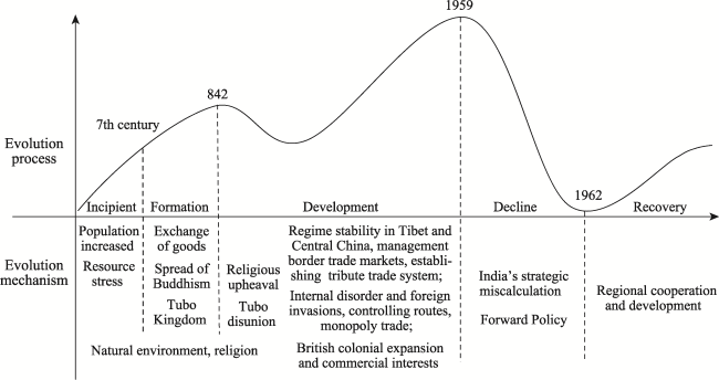
Traditional trade routes that penetrate the natural barrier of the Himalayas are critical for connecting major Chinese and South Asian markets. Research on these trade routes can contribute significantly to facilitating the construction of the South Asian Corridor and enhancing trans-Himalayan connectivity. Combining historical literature, field surveys, and geographic information system (GIS) techniques, this study examined the spatial distribution characteristics and evolution process of the routes, focusing on transverse valleys of the Himalayan arc. The key findings were as follows. First, there are 21 traditional trade routes traversing the Himalayan region: six Sino-Nepalese routes, four Sino-Bhutanese routes, and eleven Sino-Indian routes. Second, the evolution of traditional trade routes has entailed five distinct phases: an incipient period (pre-7th century), formation (7th century-842 AD), development (842-1959), decline (1959-1962) and recovery (1962-present). Third, the incipient and formative developmental phases were prompted by the spread of Buddhism and the exchange of goods. The stability of local governments in Tibet and Central China and favourable border trade policies along with Britain’s colonial expansion and commercial interests stimulated further development of traditional trade routes. However, India’s strategic miscalculation and “Forward Policy” instigated the decline phase, while the demands of regional cooperation and development are currently the key drivers of the restoration and construction phase. Finally, to shelve disputes, promote cooperation and development, and enhance political mutual trust, governments should recover and construct traditional trade routes by replanning and constructing border trade markets, expanding border trade, developing pilgrimage and tourism, and strengthening cross-border cooperative research under global climate change.

Cite this article

WU Shihai , YAN Jianzhong , ZHANG Yili , PENG Ting , SU Kangchuan . Evolutionary process and development implications of traditional trade routes in the Himalayan region[J]. Journal of Geographical Sciences, 2022 , 32(9) : 1847 -1865 . DOI: 10.1007/s11442-022-2026-1

1 Introduction

For centuries, the Himalayan mountain range has served as a natural barrier between the Tibetan Plateau and South Asia (Sun et al., 2012; Jeong et al., 2016), and this understanding has dominated the research orientation of emphasizing natural systems over human systems. The Himalayas, however, have not impeded trade and exchanges between the people of the north and south. Archaeological and historical documents indicate that a series of traditional trade routes have been formed along the fault valleys and passes of the mountains (Murton, 2016), and they became an important part of the ancient Silk Road (Tong, 2017). With the rapid development of traffic and communication technology, how to connect two huge markets in East Asia and South Asia across the Himalayas has become a strategic concern for China and other Asian countries. In May 2013, Chinese Premier Li Keqiang used “a handshake across the Himalayas” to describe the corporation and development of China-India relations (Murton et al., 2016). In August 2015, at the Sixth Chinese Government Conference on Assistance to Tibet, it was proposed “To build Tibet into an important passage for China to open to South Asia”. According to the outline of Tibet’s 13th Five-Year Plan (2016-2020), Tibet should integrate itself into the Silk Road Economic Belt and the Bangladesh-China-India-Myanmar Economic Corridor to promote economic cooperation across the Himalayas and serve as an important corridor open to South Asia. From October 11 to 13, 2019, Chinese President Xi Jinping attended the second informal meeting of Chinese and Indian leaders, paid a state visit to Nepal, and proposed to “accelerate the construction of trans-Himalayan connectivity”. Therefore, strengthening research on traditional trade routes, which are carriers across the Himalayas, is of great significance to the construction of the South Asian channel and trans-Himalayan connectivity.
As early as the 16th century, Roman Catholic missionaries crossed the Himalayas from northern India and Nepal to enter Ngari, Shigatse, and Lhasa in Tibet, China, to go on a missionary, and tried to explore a trade route from Europe through the Middle East, India, and Tibet to the Chinese mainland (Wu, 1992). In the 18th century, the British East India Company dispatched George Bogle and Samuel Turner into Tibet from Bengal in an attempt to open up a trade route with Tibet (Bergmann, 2016a). These attempts, however, failed for a variety of reasons. Therefore, the British Empire adopted a more forceful “Forward Policy” towards Tibet (Lamb, 1960; Liang, 2008). First, the British Empire annexed some kingdoms of the Himalayas, controlled the main traditional trade routes between them with Tibet, and then incorporated traditional trans-Himalayan trade into the UK-centric trading system (Pande, 2017). Second, the British Empire invaded Tibet in 1904 and opened up the trade route from Calcutta to Lhasa via Kalimpong. By the time of the Republic of China (1912-1949), the traditional Han-Tibetan trade routes from Kangding (Darchendo) along Batang to Lhasa were largely replaced by the trade route from Kalimpong to Lhasa. This situation continued until the peaceful liberation of Tibet (Dai, 2013a; Dai, 2013b). After the Sino-Indian War in 1962, traditional trade routes were interrupted, border trade declined, and border areas remained closed and semi-closed for a long time (Kreutzmann, 2007; Wallrapp et al., 2019). At the end of the 20th century, with the improvement of Sino-Indian relations, extensive attention was given to how to promote development in the Himalayan region by restoring traditional trade routes.
Chinese scholars have mainly studied the perspectives of history, historical geography, and geoeconomics. They focused on the construction and development of traditional border trade markets in Tibet (Zhang, 1993; Xie and Luosang, 1994; Ta and Pubu, 2014), small-scale border trade between China and Bhutan (Zha, 2015; Zha and Ao, 2017), traditional trade and modern trade between China and Nepal (Dong, 2008; Liang, 2017), traditional trade at Yadong port in Tibet (Chen, 2003), textual research on the traditional trade routes from Lhasa to Kashmir (Fang, 2015), the exploration of the trans-Himalayan trade routes during World War II (Zhang, 2002), and the layout of the Tibet border port under the background of the construction of the South Asian Corridor (Liu, 2018).
In contrast, Western scholars carried out research from the perspectives of anthropology and geopolitics. They studied the impact of closed traditional trade routes on the livelihoods and socioeconomic development of farmers and herdsmen in the Garhwal and Kumaon mountain regions (Bergmann et al., 2008; Wallrapp et al., 2019) and southern Tibet (Aiyadurai and Lee, 2017), the operation and existing problems of the reopened trade routes in the China-India border (Karackattu, 2013; Chettri, 2018), and the construction of the Trans-Himalayan Economic Corridor with the China-Nepal trade routes as the carrier (Datta, 2017). In summary, previous studies are mostly on the history or current situation of one or several trade routes, as well as the impact of the closure or reopening of trade routes on farmers’ livelihoods, and few investigate the spatial distribution characteristics and evolution process of traditional trade routes in the Himalayas.
Therefore, based on geographic information system (GIS) techniques, historical documents, and findings from field surveys (along the China-Nepal border from September to October 2018 and along the China-Bhutan border and China-India border from May to June 2019), this paper analyses the spatial distribution characteristics, evolution process and mechanism of traditional trade routes and proposes implications to promote the development and construction of traditional trade routes. This study will provide the basis for related research on the construction of trade routes, tourism development and cross-border cooperation in the Himalayan region and provide a scientific basis for the construction of the South Asian Corridor and trans-Himalayan connectivity.

2 Study area and method

2.1 Study area

The Himalayas, the highest and youngest mountain range on Earth, lie on the southern edge of the Tibetan Plateau, stretching from east to west across China, Bhutan, Nepal, India, and Pakistan. The mountain range runs approximately 2400 km long, covering a width of 200-350 km from north to south (Tong et al., 2013). Its western anchor, Nanga Parbat, lies in Kashmir. Its eastern anchor, Namcha Barwa, is the great bend of the Yarlung Zangbo River. The north is bound by the Yarlung Zangbo-Shiquan River, and the south is the main frontal fault on the northern boundary of the Indian Ganges Plain (Yin, 2006).
The northern and southern Himalayas are quite different. The southern mountain has a large drop, with a height difference of approximately 6000 m from the extremely high mountain to the Ganges Plain. Influenced by the southwest monsoon and westerly wind, the southern side is abundant in precipitation, which brings varied vegetation types and intense water erosion and obvious vertical zonality. Nevertheless, the north is relatively flat, with less precipitation, weak river erosion and cutting ability, sparse vegetation, flat valley terrain, and developed accumulation of landforms (Zheng, 1988). According to the flow direction of rivers and valleys, the Himalayas are divided into three sections from west to east, i.e., the western section (west of the Majia Zangbu River of Burang County in Tibet), the middle section (between the Majia Zangbu River and the Yadong River), and the eastern section (east of the Yadong River) (Qin, 1999). The western section is the Indus River Basin, the middle section is the Ganges River Basin, and the eastern section is the Brahmaputra River Basin (Lutz et al., 2014).
The Himalayan region refers to the mountainous areas in the northern and southern foothills of the Himalayas (Xia, 2004; Liu, 2017). In terms of administrative divisions, the northern foothills of the Himalayas include Ngari Prefecture (Ritu County, Gar County, Zanda County, Burang County, and Gyai County), Xigaze City, Lhasa City, Shannan City and Nyingchi City in the border area in Tibet, China, and the Ladakh region of Kashmir. The southern foothills of the Himalayas include Srinagar and Jammu in Kashmir, Himachal Pradesh, and Uttarakhand in India’s northwest border region, and Sikkim in the eastern region, as well as Nepal and Bhutan.
The Himalayan region is not only the transitional zone between the Tibetan Plateau and the South Asian subcontinent but also the hub connecting Central Asia, South Asia and East Asia (Figure 1). There are dozens of ethnic minorities in the Himalayan region, such as Tibetan, Monpa, Lhoba, Mishmi, Sherpa, Nawars, Sikkim, Bhutanese, and Kashmirians. Tibetan Buddhism is the main religious belief, with minorities believing in Bon, Shamanism, Hinduism and Islam (Xia, 2004). Traditional border trade and handicrafts play an important role in local socioeconomic development. Nevertheless, farmers’ livelihood relies more on animal husbandry and agriculture than on border trade due to their long isolation.
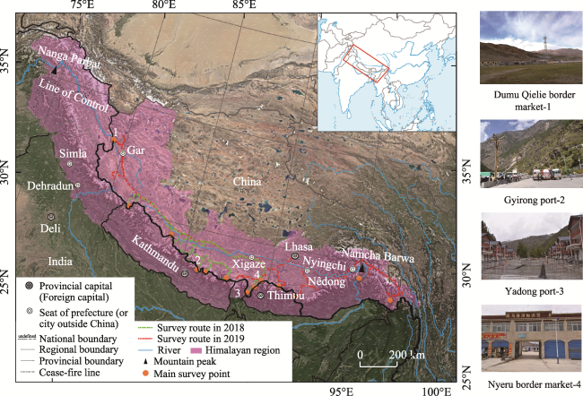
Figure 1 Location of the study area (Photos 2 and 3 were taken on 30 September and 12 October, 2018 respectively; Photos 1 and 4 were taken on June 20 and 11 June, 2019 respectively)
Written records, ethnography, and archaeological evidence all show that trade has played an important role in the Himalayan region since ancient times (Lv, 2017). A large number of ancient Greek and Latin records demonstrate that, as early as the 5th century BC, the western regions of the Tibetan Plateau had traded with the Indus Valley (Duojie, 1995). Through the traditional trade routes in the Himalayan region, Tibetan, Monpa, Lhoba, Sherpa, and other ethnic groups carried out continuous cultural and economic exchanges with people in South Asia, and many border trade points were formed in some mountain passes and along these trade routes. According to statistics, there are a total of 312 routes (44 annual passable routes and 268 seasonal passable routes) along the border of more than 3800 kilometres in the Tibet Autonomous Region of China, including 184 to Nepal, 85 to India, 18 to Bhutan, 8 to Sikkim, 5 to Myanmar and 12 to Kashmir (Feng, 2018). Nonetheless, most routes have been closed due to the influence of climatic change, human activities, and other reasons. Consequently, it is necessary to survey and analyse in detail these routes to promote socioeconomically sustainable development in the Himalayan region.

2.2 Methods

Affected by the special geological structure, several N-S-trending fault valleys have developed in partial sections of the Himalayas, forming tortuous turns and southward gaps in the mountains (SQTPCI, 1983). Over an extensive period of natural processes and human activities, these nearly N-S fault valleys, which have several rivers developed from north to south, gradually began to serve as natural channels for trade and exchanges between the Tibetan Plateau across the Himalayas and the southern neighbouring regions (TDTAR, 2001). These channels are also called “valley”.
Therefore, we first use visual interpretation to extract the fault valleys of the Himalayan region based on DEM data, river system and traffic data, and Google Earth high-definition images. Then, the main traditional trade routes are sorted according to historical documents, archaeological sites, county records of the border areas, and other factors. Finally, the spatial distribution characteristics and evolution process of traditional trade routes are analysed based on a field survey of the China-Nepal border from September to October 2018 and the China-India and China-Bhutan borders from May to June 2019 (Figure 2).
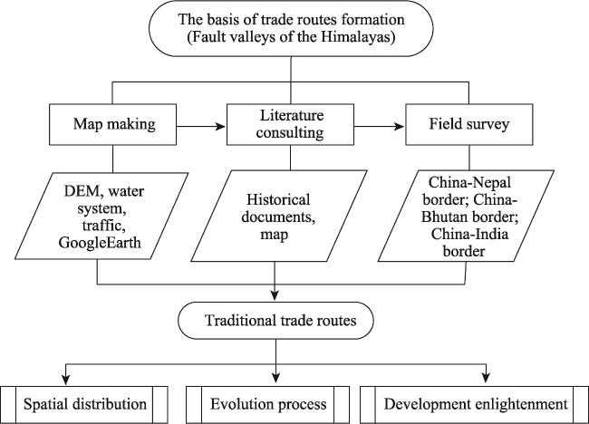
Figure 2 Research thoughts and structure
Data sources and processing: (1) The DEM adopts the SRTM DEM with a resolution of 90 m×90 m, which was obtained from the geospatial data cloud (http://www.gscloud.cn). (2) Data on river systems, traffic, and administrative boundaries were obtained from the Data Centre for Resources and Environmental Sciences, Chinese Academy of Sciences (http://www.resdc.cn/). (3) Data on historical documents in Chinese and foreign languages were collected mainly from the school library and Google Scholar, including monographs, documents, and maps, which were composed of explorers from British colonists from the end of the 19th century to the 20th century. (4) Archaeological site data were downloaded from the website of the Institute of Archaeology of the Chinese Academy of Social Sciences (http://kaogu.cssn.cn/zwb/). (5) The data obtained from field surveys include county chronicles, field surveys and interviews, as well as other relevant data and materials. Among them, county chronicles were collected from the local chronicle offices. The field survey involved 19 counties in Nyingchi City, Shannan City, Xigaze City, and Ngari Prefecture in the Tibet Autonomous Region of China: Zayu County, Medog County, Mainling County, Lhunze County, Cona County, Lhozhag County, Kangmar County, Yadong County, Gamba County, Tingkye County, Tingri County, Nyalam County, Gyirong County, Saga County, Zhongba County, Burang County, Zanda County, Gar County, and Rutog County. The field survey route is shown in Figure 1.

3 Results

3.1 Spatial distribution characteristics of traditional trade routes

Based on the identification of fault valleys in the Himalayas, combined with historical documents and field investigations, we found that there are mainly 21 traditional trade routes in the Himalayan region (Figure 3). Although previous research and statistics have revealed that there were 312 external routes along the border in the Tibet Autonomous Region of China (Feng, 2018), we discovered in the course of field investigation that many of them are difficult to pass, and some routes can only be passed by a single person or livestock. Consequently, most routes have not developed into major trade routes due to the high altitude, small radiation range, and other reasons.
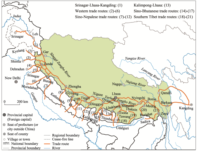
Figure 3 Spatial distribution of the traditional trade routes in the Himalayan region

3.1.1 Trade route from Srinagar to Lhasa to Kangding

This route consists of two sections: the first section is from Srinagar to Lhasa, and the second section is from Lhasa to Kangding (Figure 3, No.1). Almost all routes from the west to the east are connected to this route. Thus, this route was the most important traditional trade route in the Himalayan region. There was a large population and many settlements along the route, such as Srinagar in Kashmir, Leh in Ladakh, Gartok (Garyarsa, the centre of western Tibet), Shigatse, Lhasa, Qamdo, and Kangding. The section from Srinagar to Lhasa was regarded as “The Musk Road”, “The Wool Road”, and “The Salt Road” because musk, wool, and salt were the most representative commodities in these regions (Fang, 2015). According to the study of Fang (2015), there were 16 post stations from Srinagar to Leh, 18 post stations between Leh and Gartok, and 22 post stations from Gartok along the Yarlung Zangbo valley to Lhasa. Additionally, the traders could travel from Srinagar to India, Afghanistan, and other South and Central Asian regions. They could also travel from Leh through the Karakoram pass to the Tarim Basin in Xinjiang, China (Tong, 2017). The section from Kangding to Lhasa was the main Sino-Tibetan trade route and was of great significance to the stability and development of Tibet.

3.1.2 Western trade routes

Western trade routes, which primarily connected northwest India and western Tibet, were mainly used for pilgrimage and commerce by Hindus, Buddhists, farmers and herders, and others (Lv, 2017). Additionally, early Europeans entered Tibet for expedition mainly through these routes.
There were mainly five trade routes in the western Himalayas: Sumsan Sumba route, from Kyelang in Rahul and Spiti to Chulu Songjie and Tashigong in Tibet along the Spiti River (Figure 3, No.2); Shipki route, from Shimla, along Sutlej River, through Shipki La pass to Zanda and Gartok in Tibet (Figure 3, No.3); Gonggong Sumba route, from Dehradun to Toling, Gartok, and other places in Tibet along Bhagirathi River (Figure 3, No.4); Mana and Niti route, from Srinagar in Pauri Garhwal district, along Ganges River, through Mana pass or Niti pass to Zanda and other places in Tibet (Figure 3, No.5). In 1624, Andrade, a Jesuit missionary, and his fellows, taking the missionary opportunity, arrived at Guge in Tibet along the Sutlej valley through Mana pass to explore land routes from Europe to China, but the action eventually led to the war between Ladakh and Guge, resulting in the destruction of Guge (Wu, 1992). Lipu Lekh route, from Moradabad, along the Kali River, through Lipu Lekh pass to Burang, Gyanyima, Mount Kailash, and other places in Tibet (Figure 3, No.6).

3.1.3 Sino-Nepalese trade routes

The traditional trade between China and Nepal has a long history. Since the Han and Tang dynasties, there have been silk trade routes from the Chinese mainland through Tibet, Nepal and India. There were six trade routes between China and Nepal: Majia Zangbo route, from Nepal to Burang and Mount Kailash along Karnali River (Figure 3, No.7); Mustang route, from Mustang to Zhongba in Tibet along Kali Gandaki River (Figure 3, No.8); Gyirong route, from Katmandu to Gyirong, and other places in Tibet along Gyirong valley (Figure 3, No.9); Zhangmu route, from Katmandu to Nyalam, and other places in Tibet along Zhangmu valley (Figure 3, No.10); Rongxia route, from Nepal to Rongxia, Tingri, and other places in Tibet along Rongxia valley (Figure 3, No.11); Chentang route, from Nepal to Tingkye, and other places in Tibet along Chentang valley or Gama valley (Figure 3, No.12).
Among these routes, the Gyirong route and Zhangmu route were the most commonly used and the most prosperous. The Gyrong route is also known as the “Ancient Tubo-Nepal Road”, by which Bhrikuti of Nepal married Tubo from Nepal, and Tang Dynasty diplomats Li Yibiao and Wang Xuance arrived in India (Duojie, 1995).

3.1.4 Trade route from Kalimpong to Lhasa

This route was forced open by British colonists in 1904 and then became the most important trade route between Tibet and South Asia during the first half of the 20th century (Figure 3, No.13). The British colonists forced the signing of the “Lhasa Convention”, which opened trading ports in Yadong, Gyantse, and Gartok. Since then, this route has developed rapidly, with the British building 11 post stations from Yadong to Gyantse. Before the 1962 war, traffic across this route accounted for 80% of the total border trade volume between India and Tibet, China (Karackattu, 2013).

3.1.5 Sino-Bhutanese trade routes

Under the impacts of a special geographical environment and religious beliefs, the trade between Bhutan and Tibet has been ongoing for a long time, and several traditional trade routes have been formed along the fault valleys of the Himalayas (Williams, 2017; Zha and Ao, 2017), four of which are the main routes. Tremo La route, from Paro in Bhutan to Pagri in Tibet crossing Tremo La pass (Figure 3, No.14). In the 18th century, the British East India Company sent George Bogle to Tibet through this route in an attempt to open the trade route with Tibet (Sarkar and Ray, 2006). Sankosh route, from Punakha in Bhutan to Kangmar in Tibet along Sankosh River (Figure 3, No.15); Lhozhag route, from Tongsa in Bhutan to Lhakhang in Tibet, Shangnan, and Lhasa along Lhobrak River (Figure 3, No.16); Lebo route, from Tashigang in Bhutan to Tsona in Tibet along Manas River (Figure 3, No.17).

3.1.6 Southern Tibet trade routes

Southern Tibet, mainly inhabited by Chinese ethnic groups such as the Lopa, Menpa and Mishmi, was divided into the Loyu, Menyu, and Tsayul regions. Since ancient times, they have continued to trade with Tibetans and people from the Assam plains and have developed trade markets along border regions (Xu, 1936; Zha and Liu, 2014). There were mainly four routes: Tawang route, from Udalguri to Tawang, Tsona crossing Dirang and Se La pass (Figure 3, No.18); Subansiri route, from Assam plains to Thaksin and Lhuntse along Subansiri River (Figure 3, No.19); Motuo route, from Pasighat to Medog, Bome and other places in Tibet along Yarlung Zangbo River (Figure 3, No.20); Zayu route, from Sadiya to Zayu along Zayu River (Figure 3, No.21).

3.2 Evolution process of traditional trade routes

Influenced by both natural and human factors, the traditional trade routes in the Himalayan region have constantly evolved. According to major historical events that greatly impacted the traditional trade routes in different periods, the evolution of the trade routes is divided into five phases, i.e., incipient, formation, development, decline, and recovery (Table 1).
Table 1 The evolution of traditional trade routes in the Himalayan region
Phase Symbol Changes in routes
Incipient period
(Pre-7th century)
Tribal stages, many tribes formed on the Tibetan Plateau Preliminarily went through the trade route from Srinagar to western Tibet
Formation period
(7th century-842 AD)
In the 7th century, Songtsen Gambo established the Tubo Kingdom; in 842 AD, Tubo went into the era of fragmentation. Opened the trade routes from Srinagar to Lhasa, and from Kathmandu to Lhasa
Development period
(842-1959)
After the development of Yuan, Ming and Qing dynasties, and the exploration of European missionaries and British colonists, Tibetan rebelled in 1959. Opened the trade routes from the west to the east along the Himalayas but stopped to the southern Tibet owing to the World War II.
Decline period
(1959-1962)
Sino-Indian War of 1962 All trade routes were closed besides Gyirong route and Zhangmu route.
Recovery period
(1962-present)
The Sino-Indian relations has improved since the 1980s; the cooperation between China and Nepal constantly enhanced. The Sino-Indian trade routes have recovered Lipu Lekh pass, Shipki La pass, Nathu La pass; the Sino-Nepalese trade routes have opened Zhangmu, Gyirong, Riwu-Chentang, Lizi, Burang land ports.

3.2.1 Incipient period (pre-7th century)

In recent years, new archaeological discoveries and historical records have demonstrated that 5000 years ago (Upper Palaeolithic and Neolithic age), the Tibetan Plateau was closely connected with the surrounding areas of the Himalayas, South Asia, the Central Plains of China, and the upper reaches of the Yellow River (Huo, 2013; Liu, 2017; Xu, 2018). To the early metal-smelting age, small tribes stood in great numbers, and the trade between the tribes was carried out with the war. After a series of merges, the three powerful tribal alliances of Zhang Zhung (Chinese: Xiangxiong), Yarlung tribe, and Sumpa tribe had been gradually formed on the Tibetan Plateau (Zhang, 2016). Because of its superior geographical location, Zhang Zhung, which is centred on the western region of the Tibetan Plateau, has become a regional political, cultural and commercial centre closely related to the Xinjiang, Central Asia and South Asian subcontinents in the Han to Jin dynasties, preliminarily passing through the “Plateau Silk Road” from western Tibet to the Western Regions, Central Asia and the South Asian subcontinent (Huo and Huo, 2017). This road was connected mainly through Ladakh of the Himalayan region (Tong, 2017). After the 6th century AD, the Yalong tribe conquered Zhang Zhung and other tribes, established the Tubo Kingdom, and completed the unification of the Tibetan Plateau, laying the foundation for the formation and development of traditional trade routes.

3.2.2 Formation period (7th century-842 AD)

The Tubo Kingdom reached its peak in the 7th century to 842 AD. First, Tubo opened the “Ancient Tang-Tibet Road” and “Ancient Tubo-Nepal Road”, which were the branches of the Silk Road from Tubo to South Asia, by establishing its capital in Lhasa and allying itself with Zhang Zhung, Muya, Nepal, and Tang Dynasty through political marriage (Duojie, 2016). Second, with its resource advantage, the routes known as “The Musk Route” or “The Salt Route” were opened from Lhasa through Ngari Prefecture and Ladakh to Central Asia and South Asia (Li, 2017). Third, with Buddhism flourishing, Tibetan Buddhism began to spread rapidly to the southern foothills of the Himalayas, such as Bhutan, Sikkim and Ladakh, and gradually opened up trade and pilgrimage routes with these areas.

3.2.3 Development period (842-1959)

In 842 AD, Langdama was assassinated by a Buddhist hermit for persecuting Buddhists. From then on, Tubo entered a period of fragmentation, and western Tibet was further divided into three local regimes, Guge, Ladakh and Purang (Huang, 2012). For this reason, a large number of Buddhists fled to the surrounding areas, such as Ngari, Nepal, Bhutan, and Sikkim (Petech and Zhang, 2012), and the trade routes declined to some extent. At the end of the 13th century, the Yuan Dynasty incorporated Tibet into its territory. Yuan put an end to the separatist rule over Tibet and set up post stations along routes, which promoted the construction and development of the routes. The Ming Dynasty followed the Yuan Dynasty’s rule over Tibet and established suzerain-vassal relations with neighbouring areas such as Sikkim and Bhutan, gradually forming a “tributary trade” system. From the end of the 16th century to the middle of the 17th century, European missionaries entered Tibet from Ngari with the banner of missionaries. Their main purpose was to find a land route from Europe to China in the hope of exporting goods to China, but they were unsuccessful (Wu, 1992). In the 18th century, Britain intervened in the South Asian subcontinent and began to seek land access to the Chinese mainland from all directions in the Himalayas. First, Britain defeated Nepal, annexed the Garhwal and Kumaon districts in the western section of the Himalayas, and controlled the traditional trade routes in the western section between India and China (Bergmann, 2016b; Lamb and Deng, 2016a). Then, Britain invaded the Darjeeling of the Sikkim, Bhutan, and Assam plains and controlled the Sino-Bhutanese trade routes. Finally, British colonialists invaded Tibet by force in 1904, opened the trade route from Kalimpong through Yadong to Lhasa, and opened the three trading ports of Yadong, Gyantse, and Gartok (Lamb and Deng, 2016b). In 1914, Britain illegally delineated the McMahon Line and attempted to control and open the Tawang route, Medog route, and Zayu route in southern Tibet (Wu, 1988; Goldstein, 2005; Liang, 2015). After the founding of the People’s Republic of China, the Sichuan-Tibet Highway was constructed in 1954, which further strengthened the connection between Tibet and the hinterland. Subsequently, the agreement between the Republic of India and the People’s Republic of China on Trade and Intercourse between Tibet of China and India was inked on April 29, 1954. According to the agreement, Gartok, Pulanchung (Taklakot), Gyanima-Khargo, Gyanima-Chakra, Ramura, Dongbra, Pulang-Sumdo, Nabra, Shangtse and Tashigong were opened as markets for trade; Shipki La pass, Mana pass, Niti pass, Kungri Bingri pass, Darma pass and Lipu Lekh pass were opened as routes for traders and pilgrims. Meanwhile, the agreement (September 20, 1956) was inked to promote border trade between China and Nepal. Since then, the Sino-Nepalese trade routes have developed rapidly.

3.2.4 Decline period (1959-1962)

After independence (1947), India tried to inherit the legacy of British colonization, including monopolizing trade by controlling traditional trade routes and creating a buffer zone by implementing the “Forward Policy” (Maxwell, 1981). In March 1959, India took advantage of a rebellion in Lhasa of Tibet to interfere in China’s internal affairs. In April of that year, India began to impose an embargo on Tibet and blocked the trade route from Kalimpong to Lhasa, preventing Tibetan merchants and trade caravans from carrying goods through the route and disrupting the normal activities of Chinese commercial agencies in Kalimpong and Kolkata (Dai, 2013a; Dai, 2013b). In mid-1959, India provoked border disputes, including the Longjiu incident in August and the Kongka La incident in October, which led directly to a sharp deterioration in relations between the two nations. At the same time, given that the agreement between India and China (April 29, 1954) would expire on June 3, 1962, the Chinese government proposed that the two counties negotiate a new trade agreement. This proposal, however, was rejected by the Indian government twice, in December 1961 and May 1962. Thus, the Chinese government cancelled commercial agencies in Kalimpong and Kolkata after the agreement expired. Finally, the outbreak of the Sino-Indian war at the end of 1962 directly led to the closure of all traditional trade routes in the Himalayan region except the Zhangmu and Gyirong routes.

3.2.5 Recovery period (1962-present)

After the war of 1962, trade in the Himalayan region mainly focused on the Sino-Nepalese trade routes. Furthermore, the border areas of China and Nepal were successively opened, including ports of Zhangmu, Burang, Riwu-Chentang, Gyirong, and Lizi. According to statistical data from the Ministry of Commerce of China, the trade volume between China and Nepal increased from 204 million US dollars in 2000 to 1.1 billion US dollars in 2018. With increasing demands for regional cooperation and development, the Sino-Indian relationship improved in the 1980s, and some traditional trade routes were reopened. The border trade across the Lipu Lekh pass and Shipki La pass resumed in 1992 and 1993, respectively, followed by the reopening of trade across the Nathu La on July 6, 2006. Nathu La became a new pilgrimage route for India’s official pilgrims in June 2015. In addition, according to our field survey, although a few small-scale trade markets were recovered, they have been almost closed due to the impacts of Sino-Indian relations in recent years. Currently, owing to Indian-controlled Bhutanese diplomacy, the traditional trade routes between Bhutan and China remain closed, except for some small-scale border trades (Zha, 2015). According to our field survey, the small-scale trade markets between Bhutan and China, such as Nyeru in Kangmar, Kuju in Cona, Pagri and Tuna in Yadong, and Se in Lhozhag, faced the same challenges with the Sino-India border due to India’s intervention.

3.3 Evolution mechanism of traditional trade routes

Based on the natural environment and the spread of Buddhism, traditional trade routes in the Himalayan region were changing constantly by regime stability in Tibet and Central China, border trade policies, and strategic interests at different times (Figure 4).
Figure 4 Evolution mechanism of traditional trade routes in the Himalayan region

3.3.1 Exchange of goods and Buddhism expansion drive the incipient and formation of routes

With the rapid development of productivity, an increasing number of people across several tribes and additional pressure on natural resources, people needed to both survive and continue development of the region through the exchange of goods. On the northern side of the Himalayas, livestock farming was well developed and goods such as wool, salt and borax were abundant. On the southern side of the range, grain crops such as rice and wheat were abundant, so people began to meet their basic needs by exchanging salt and grain and gradually formed an interdependent agro-trader-pastoralist economy (Vasan, 2006). In addition, due to the difficulty of accessing these border regions from the mainland on either side, farmers and herders preferred to trade with each other (Karackattu, 2013). Therefore, the exchange of goods that developed to meet people’s basic needs drove the incipient and development of traditional trade routes.
The Tubo Kingdom not only opened the “Ancient Tang-Tibet Road” and “Ancient Tubo-Nepal Road” through Buddhism but also made Kashmir, Bhutan and Sikkim subordinate in the Himalayan region. Mount Kailash and Lake Manasarovar, located in the Ngari Prefecture of Tibet, are regarded as common to the spiritual beliefs by Hinduism, Buddhism, Benjamin and Jainism (Xia, 2004). The people of the Himalayan region have long had a tradition of making pilgrimages to the sacred mountains and lakes through routes such as the Lipu Lekh pass and the Shipki La pass, which serve as both pilgrimages and traditional trade routes.

3.3.2 Regime stability in Tibet and Central China, implementation of border trade policies, British colonial expansion and commercial interests stimulate the development of routes

The Tubo Kingdom unified the Tibetan Plateau and opened up external routes linking Central, South and East Asia with the interior of the Tibetan Plateau. During the period when a strong unified dynasty was established in Central China, an active frontier policy was adopted, great importance was attached to strengthening transport links with the frontier regions, including the Tibetan region, and a system of tribute trade was gradually established to promote the development of routes. Before the 18th century, trade in the Himalayan region was mainly controlled and privileged by merchants from Kashmir and Nepal, with trade concentrated along the Gyirong route and Nyalam route (Xu, 2018). After the Gurkha War of 1791-1793, which was triggered by commercial trade and currency, the Qing government promulgated the Imperially Approved Ordinance for Better Governance of Tibet (the 29-Article Ordinance), standardized border trade, and established tribute relations between the Qing Dynasty and the Himalayan periphery. In contrast, during the decline of successive dynasties and the period when the interior was under multiple regimes, the ability of the Central Plains dynasties to manage within the Tibetan Plateau region was relatively weakened, and the routes were controlled by external forces. From 1912 to 1949, due to domestic political turmoil, the British and other imperialist forces intervened and sabotaged the “independence of Tibet”, trying to block the links between the Chinese mainland and Tibet, control trade routes, and monopolize trade. In 1904, the British invaded Tibet and signed the Treaty of Lhasa, establishing commercial representative offices at the Yadong, Gyantse, and Gartok ports, enjoying trade privileges and using colonial means to gradually explore and control access to the Himalayan region (Zha and Liu, 2014).
Driven by colonial expansion and commercial interests, from Western missionaries to British colonists, they have sought to open land routes to the Chinese mainland. In terms of the way Britain opened routes, first, they reduced production costs by using industrial revolution technologies, growing tea, and exploiting minerals such as borax and salt to replace products from the Chinese mainland. Second, they improved accessibility, reduced transport costs, and enhanced trade between the Himalayan region and the Ganges Plain region by building infrastructures such as railways and roads. Third, they annexed Himalayan countries through war and established the treaty system centred on the British to replace the tribute system centred on China (Li, 2018), control trade routes, and monopolize the trade between the Himalayan region and South Asia. This also eventually led to the Himalayan region trading more closely with South Asia. However, as a result of the World War II, the opening of southern Tibet trade routes was not achieved.

3.3.3 India’s strategic miscalculation and forward policy instigated the decline of routes

After independence in 1947, India sought to inherit the legacy of British colonization, continued to control traditional trade routes, and monopolized trade in the Himalayan region. Between 1950 and 1962, India imposed two trade controls and embargoed Tibet in China using the control of trade routes (Dai, 2013a; 2013b). At the same time, as India exercised strategic provocation against China, believing that “as long as India did not attack Chinese positions, China would not intervene no matter how many posts and patrols India sent into the territories claimed and occupied by China”, and embarked on a “Forward Policy” (Maxwell, 1981). This eventually led to the Sino-Indian border conflict in 1962, which caused the rapid decline of traditional trade routes.

3.3.4 Demands of regional cooperation and development are driving the restoration and construction of routes

In the 1980s, some of the traditional trade routes began to reopen as Sino-Indian relations improved. Since 2004, China has been India’s largest source of imports and third- or fourth-largest export market and has become India’s largest trading partner in 2013. India’s exports to China are mostly primary products such as resource products and raw materials, whereas China’s exports to India are mainly labour-intensive manufactured goods, with strong complementarity between the two sides. However, the current trade between India and China is mainly done through the sea route, but there remains potential for the development of land routes in the Himalayan region.
As the Belt and Road Initiative continues to advance, the Himalayan region is receiving increasing attention and importance as a pivot between China and South Asia. China has proposed specific strategies, such as the Bangladesh-China-India-Myanmar Economic Corridor, the China-Pakistan Economic Corridor, the construction of the South Asia Corridor, the China-Nepal-India Economic Corridor and the Trans-Himalayan Economic Corridor. Traditional trade routes in the Himalayan region will be key to the implementation of these strategies. Therefore, the restoration and construction of traditional trade routes will be an opportunity.
At the same time, Nepal and Bhutan are often considered “the proverbial yam sandwiched between two boulders” of China and India (Harris, 2013). The transitional economic dependence of Nepal and Bhutan on India has led to frequent Indian intervention and control of their domestic politics. For this reason, both Nepal and Bhutan wish to break away from their overdependence on India and thus become a bridgehead for economic and cultural development between India and China through the rehabilitation and construction of traditional trade routes in the Himalayan region.

4 Conclusions and development implications

4.1 Conclusions

Based on GIS technology, historical documents and field survey data, this study analyses the spatial distribution characteristics and evolution of traditional trade routes in the Himalayan region. The major conclusions are as follows.
(1) There are 21 traditional trade routes in the Himalayan region, including six Sino-Nepalese routes, four Sino-Bhutanese routes, and eleven Sino-Indian routes.
(2) According to major historical events that significantly influenced the development of traditional trade routes in different periods, the evolution of the routes was divided into five phases: incipient, formation, development, decline and recovery. In the incipient period, the expansion of human activities and the war between tribes promoted the preliminary connection of traditional trade routes on the Tibetan Plateau. In the formation period, the unification and expansion of Tubo boosted the formation of trade routes. The period of development was shown in three aspects. First, traditional trade routes declined somewhat due to religious disputes. Second, the routes were soon restored and developed rapidly with the formation of tribute trade in the Himalayan region. Third, after long-term exploration of traditional trade routes by European missionaries and British colonists from the 17th century to the 20th century, the trade route between Kalimpong and Lhasa was opened by force and developed into the most important trade route in the Himalayan region in 1959. Nevertheless, the decline period showed that the trade routes were almost closed owing to the war of 1962. In the recovery period, some traditional trade routes were reopened with the improvement of the Sino-Indian relations.
(3) The natural environmental differences between the northern and southern sides of the Himalayas provided the basis for the formation of trade routes. Barter trade, in which grain was exchanged for salt to meet people’s daily needs, contributed to the sprouting of traditional trade routes. On the one hand, the introduction and spread of Tibetan Buddhism promoted the formation and development of traditional trade routes; on the other hand, these routes were weakened later by religious disputes. Tribute trade and British colonial expansion and commercial interests further promoted the development of trade routes. Nevertheless, India’s strategic miscalculation and forward policy caused border conflict between China and India, which directly led to the rapid decline of trade routes as well as the long-term closure and backwardness of the Himalayan region. At present, the demands of regional cooperation and development have, to some extent, promoted the recovery and development of traditional trade routes.

4.2 Development implications

In the evolution of traditional trade routes, the rise and fall of routes are closely related to the development and stability of the Himalayan region. The opening and construction of the routes have promoted the rapid social and economic development of the Himalayan region and made this region a trading hub connecting Central Asia, South Asia, East Asia, and even Europe. In contrast, the region was closed and backwards. Therefore, under globalization, speeding up the restoration and construction of trade routes from multiple perspectives is the key to shelving disputes and seeking common development.
(1) Due to changes in products and transportation modes, governments should plan and rebuild the border trade market to promote the construction and development of trade routes. With the development of transportation and technology, traditional goods such as salt and grain have been replaced by various commodities from the domestic markets of each country. Consequently, the products of border trade have changed from the traditional salt trade to modern light industrial products. Furthermore, goods are now transported by modern means such as cars rather than by people or horses. Moreover, highways or railways have replaced traditional mule caravan paths. The transformation of trade products, transportation methods and road types will bring new requirements to the construction of traditional border trade markets. Thus, it is necessary to replan and construct border trade markets to promote the construction and development of trade routes.
(2) Governments should take advantage of trade routes to realize the complementarity of the two major markets in East Asia and South Asia, thereby further improving cooperation and development in the Himalayan region. In the face of highly complementary trade between India and China, there is great potential for cooperation and development along land routes between China and India. However, the restoration and construction of traditional trade routes were slow due to the lack of strategic mutual trust and border disputes. Currently, only the Lipu Lekh pass, Shipki La pass, and Nathu La pass are operating along the actual control line of the land border between China and India for more than 2000 kilometres. The statistics also show that the trade volume through the Nathu la pass was 24 million US dollars in 2015, less than 1/9 of that across the China-Nepal border and negligible compared with the total trade between China and India. Furthermore, India has inherited and implemented the “Forward Policy” for a long time, which has resulted in the long-term closure of border crossings, the decline in traditional border trade markets, border hollowing (Bergmann, 2016a), changes to local farmers’ livelihood (Beszterda, 2015), and the absence of sociocultural cross-border interactions between two countries (Vasan, 2006). Therefore, cooperation is the best choice to serve the national interests of China and India and is also the expectation of poor inland countries and regions such as Bhutan and Nepal that have long been impacted by the Sino-India relation.
(3) Governments should make full use of trade routes for pilgrimage and tourism to enhance mutual political trust, deepen cultural exchanges, and promote China-India cooperation. There are many ethnic groups in the Himalayan region, most of which live across borders, with similar production and living habits. Since ancient times, there has been a friendly tradition in religion, trade, and culture. Mount Kailash and Lake Manasarovar, located in Ngari Prefecture in Tibet, China, were deemed to be the centre of the world by Hinduism, Tibetan Buddhism, Bon, and Jaina. For this reason, it has attracted countless pilgrims. Pilgrimage tourism has become the main driving force of social and economic development on the southern slope of the western Himalayas (Sati, 2015). In the border area in Himachal Pradesh of India, most respondents believe that the pilgrimage route across Shipki La pass is shorter and easier and thus has great potential for tourism (Vasan, 2006). To make it easier for Indian pilgrims to go to Mount Kailash and Lake Manasarovar, the Chinese government opened the Nathu La pass as a second pilgrimage route in 2015, increasing the number of Indian pilgrims from hundreds every year in the 1980s to more than 20,000 in 2018 (Chand, 2019). This expanded the nongovernmental and cultural exchanges between China and India to a certain extent. On October 12, 2019, Chinese President Xi Jinping and Indian Prime Minister Narendra Modi agreed that 2020 will be the year of cultural and people-to-people exchanges between China and India, which will further expand and deepen the nongovernmental and cultural exchanges and bring China-Indian relations to a new milestone. To this end, it is in the common interests of both countries to promote the restoration and construction of Sino-Indian trade routes, revitalize the border areas and enhance strategic mutual trust through tourism, cooperation and development.
(4) Dubbed “Asia’s water tower”, the Himalayan region is the birthplace of major rivers such as the Ganges, Brahmaputra and Indus in Asia, providing not only water for food and energy production downstream but also maintaining a range of ecosystem services (Immerzeel et al., 2020). This region is highly sensitive and prone to global climate change and human activities due to the extremely fragile ecological environment. In particular, as the population continues to grow, green, low-carbon sustainable development of the Himalayan region is critical to ensure the ecological security of the Asian region. The restoration and construction of traditional border trade will help improve the livelihoods of local farmers and herders, drive rapid development of tourism and promote sustainable development in the Himalayan region. Thus, governments should take advantage of the construction of traditional trade routes to carry out cross-border cooperative research on water resources, land resources, and biological resources under the backdrop of climate change in the future (Deng et al., 2013) to strengthen cooperation and communication in the comprehensive development of river basins, cope with the impact of global climate change, jointly serve regional development, and enhance regional strategic mutual trust.
[1]
Aiyadurai A, Lee C S, 2017. Living on the Sino-Indian border the story of the Mishmis in Arunachal Pradesh, northeast India. Asian Ethnology, 76(2): 367-395.

[2]
Bergmann C, 2016a. The Himalayan Border Region:Trade, Identity and Mobility in Kumaon, India, Cham: Springer International Publishing, 23-73.

[3]
Bergmann C, 2016b. Confluent territories and overlapping sovereignties: Britain’s nineteenth-century Indian empire in the Kumaon Himalaya. Journal of Historical Geography, 51: 88-98.

DOI

[4]
Bergmann C, Gerwin M, Nüsser M et al., 2008. Living in a high mountain border region: The case of the ‘Bhotiyas’ of the Indo-Chinese border region. Journal of Mountain Science, 5(3): 209-217.

DOI

[5]
Beszterda R, 2015. The Shipki La and its place in cross-border trade between India and Tibet. The Tibet Journal, 40(2): 239-259.

[6]
Chand B, 2019. Dynamics of rivalry between geographically contiguous regional powers: The case of Sino-Indian competition. Asian Politics & Policy, 11(1): 122-143.

[7]
Chen J D, 2003. The trade relation between Yadong of Tibet and India in modern history. South Asian Studies Quarterly, (4): 61-64, 80. (in Chinese)

[8]
Chettri P, 2018. India-China border trade through Nathu La Pass: Prospects and impediments. Himalaya, 38: 11-22.

[9]
Dai C W, 2013a. India’s trade controls and embargoes on Tibet and China’s reactions and policies (1950-1962) (I). CPC History Studies, (6): 24-37. (in Chinese)

[10]
Dai C W, 2013b. India’s trade controls and embargoes on Tibet and China’s reactions and policies (1950-1962) (Ⅱ). CPC History Studies, (7): 57-70. (in Chinese)

[11]
Datta S, 2017. India: The Bridge Linking South and Southeast Asia. London: Global Policy and Observer Research Foundation, 16-23.

[12]
Deng W, Zhang J F, Hu Y et al., 2013. A consideration of cooperation in science and technology of South Asia based on the geopolitical perspective. Bulletin of the Chinese Academy of Sciences, 28(6): 725-732. (in Chinese)

[13]
Dong L Y, 2008. Trade between Tibet and Nepal. China Tibetology, (1): 218-222. (in Chinese)

[14]
Duojie C D, 1995. On the ancient Tibet traffic route of the Silk Road. Chinese Culture Tradition and Modernization, (4): 45-54. (in Chinese)

[15]
Duojie C D, 2016. Tubo study two or three questions. China Tibetology, (Suppl.1): 122-132. (in Chinese)

[16]
Fang J C, 2015. Brief notes on modern Tibetan musk routes and its changes. Tibetan Studies, (4): 17-37. (in Chinese)

[17]
Feng K Y, 2018. Analysis of the border trade between Nepal and Tibet in modern China. China International Business, (2): 1-2. (in Chinese)

[18]
Goldstein M, 2005. A History of Modern Tibet, 1913-1951: The Demise of the Lamaist State. Beijing: China Tibetology Press. (in Chinese)

[19]
Harris T, 2013. Trading places: New economic geographies across Himalayan borderlands. Political Geography, 35: 60-68.

DOI

[20]
Huang B, 2012. Separation of the three dimensions: The political pattern and political differentiation of the Ali dynasty in the 11th century. China Tibetology, (3): 35-42. (in Chinese)

[21]
Huo C, Huo W, 2017. The open of “Plateau Silk Road” in west Tibet during the Han and Jin dynasties and its historic significance. Journal of Tibet University, 32(1): 52-57. (in Chinese)

[22]
Huo W, 2013. Rediscovering the prehistoric transportation and trade in Tibet from archaeological discoveries. China Tibetology, (2): 5-24. (in Chinese)

[23]
Immerzeel W W, Lutz A F, Andrade M et al., 2020. Importance and vulnerability of the world’s water towers. Nature, 577(7790): 364-369.

DOI

[24]
Jeong C, Ozga A T, Witonsky D B et al., 2016. Long-term genetic stability and a high-altitude East Asian origin for the peoples of the high valleys of the Himalayan arc. Proceedings of the National Academy of Sciences of the United States of America, 113(27): 7485-7490.

DOI PMID

[25]
Karackattu J T, 2013. India-China trade at the borders: Challenges and opportunities. Journal of Contemporary China, 22(82): 691-711.

DOI

[26]
Kreutzmann H, 2007. Boundaries and trade-geopolitical implications in the Indo-Chinese mountain barrier of eastern High Asia. Geographische Rundschau, 59(11): 4-11.

[27]
Lamb A, 1960. Britain and Chinese Central Asia: The Road to Lhasa, 1767 to 1905. London: Routledge and Paul.

[28]
Lamb A, Deng R L, 2016a. Selected translation of Tibet and the British Raj. Journal of Xizang Minzu University (Philosophy and Social Sciences Edition), 37(2): 39-54, 154. (in Chinese)

[29]
Lamb A, Deng R L, 2016b. Selected translation of British India and Tibet 1766-1910. Journal of Xizang Minzu University (Philosophy and Social Sciences Edition), 37(3): 47-57, 154. (in Chinese)

[30]
Li T, 2017. The salt road that was once as famous as the “Silk Road”. China Salt Industry, (18): 64-67. (in Chinese)

[31]
Li Y M, 2018. The main difference between late Qing Sino-foreign treaty relationships and tributary telationships. Historical Research, (5): 53-70, 190. (in Chinese)

[32]
Liang J Y, 2008. British landway strategy toward China from late 18th century to early 20th century. World History, (5): 47-55. (in Chinese)

[33]
Liang J Y, 2015. Translation of selected from the McMahon Line (V). Journal of Xizang Minzu University (Philosophy and Social Sciences Edition), 36(6): 37-48. (in Chinese)

[34]
Liang J Y, 2017. Study on the contemporary trade development between China and Nepal. China Tibetology, (3): 52-58. (in Chinese)

[35]
Liu Y, 2018. On the spatial layout, development and countermeasures of the land border crossings in Tibet from the geoeconomic perspective. Journal of Tibet University, 33(2): 195-204. (in Chinese)

[36]
Liu Z Y, 2017. Ethnic composition and cultural interaction on Qinghai-Tibet Plateau and its neighboring regions. Ethno-National Studies, (2): 55-67, 124. (in Chinese)

[37]
Lutz A F, Immerzeel W W, Shrestha A B et al., 2014. Consistent increase in High Asia’s runoff due to increasing glacier melt and precipitation. Nature Climate Change, 4(7): 587-592.

DOI

[38]
Lv H L, 2017. West of Tibet: The earliest mountain people in the Himalayas. Tibet Geographic, (3): 56-69. (in Chinese)

[39]
Maxwell N, 1981. India’s China War. Beijing: World Affairs Press. (in Chinese)

[40]
Murton G, 2016. Trans-Himalayan transformations:Building roads, making markets, and cultivating consumption between Nepal and China’s Tibet. In: Zhou Yongming (ed.). Roadology: Roads, Space, and Culture. Chongqing: Chongqing University Press, 328-340.

[41]
Murton G, Lord A, Beazley R, 2016. “A handshake across the Himalayas:” Chinese investment, hydropower development, and state formation in Nepal. Eurasian Geography and Economics, 57(3): 403-432.

DOI

[42]
Pande V, 2017. Borderlands, empires and nations: Himalayan and trans-Himalayan borderlands (c 1815-1930). Economic & Political Weekly, 52(15): 68-78.

[43]
Petech L, Zhang C H, 2012. Translation of western Tibet: Historical introduction. Journal of Tibetology, (1): 135-176. (in Chinese)

[44]
Qin D H, 1999. Map of Glacier Resources in the Himalayas. Beijing: Science Press, 7. (in Chinese)

[45]
Sarkar R, Ray I, 2006. Two nineteenth century trade routes in the Eastern Himalayas: The Bhutanese trade with Tibet and Bengal. Journal of Bhutan Studies: 56-83.

[46]
Sati V P, 2015. Pilgrimage tourism in mountain regions: Socio-economic and environmental implications in the Garhwal Himalaya. South Asian Journal of Tourism and Heritage, 8(2): 164-182.

[47]
Sciences Qinghai-Tibet Plateau Comprehensive Investigation (SQTPCI), 1983. Tibetan Landscape. Beijing: Science Press. (in Chinese)

[48]
Sun H L, Zheng D, Yao T D et al., 2012. Protection and construction of the national ecological security shelter zone on Tibetan Plateau. Acta Geographica Sinica, 67(1): 3-12. (in Chinese)

DOI

[49]
Ta S, Pubu T R, 2014. An analysis of the history and current state of Tibet’s border trade. Journal of Tibet University, 29(3): 1-7. (in Chinese)

[50]
Tong L Q, Nie H F, Li J C et al., 2013. Survey of large-scale debris flow and study of its development characteristics using remote sensing technology in the Himalayas. Remote Sensing for Land & Resources, 25(4): 104-112. (in Chinese)

[51]
Tong T, 2017. Silks and the Silk Road in western Tibet. Journal of National Museum of China, (2): 6-16. (in Chinese)

[52]
Transportation Department of Tibet Autonomous Region (TDTAR), 2001. Tibet’s Ancient and Modern Transportation History. Beijing: China Communications Press. (in Chinese)

[53]
Vasan S, 2006. Indo-Tibetan border trade in Himachal Pradesh. China Report, 42(1): 41-55.

DOI

[54]
Wallrapp C, Faust H, Keck M, 2019. Production networks and borderlands: Cross-border yarsagumba trade in the Kailash Landscape. Journal of Rural Studies, 66: 67-76.

DOI

[55]
Williams T, 2017. Silk roads in the Kingdom of Bhutan and the development of a national heritage inventory. Archaeology International, 19: 122-133.

[56]
Wu C Z, 1988. A brief history of the British invasion of southeastern Tibet. Tibetan Studies, (3): 35-42, 92. (in Chinese)

[57]
Wu K M, 1992. A History of the Actives of Early Missionaries in Tibet. Beijing: China Tibetology Press. (in Chinese)

[58]
Xia M, 2004. Ecological distribution of religions in the Himalayas. Journal of Xizang Minzu University(Philosophy and Social Sciences Edition), (6): 1-4, 9. (in Chinese)

[59]
Xie Y J, Luosang Q J, 1994. A historical review of the trade situation on the border of Tibet. Journal of Tibet University, (3): 48-51. (in Chinese)

[60]
Xu J Z, 1936. Trails on the frontier of Tibet and Sikang, their importance. Acta Geographica Sinica, 3(4): 713-726. (in Chinese)

DOI

[61]
Xu X Y, 2018. The history and reality of economic exchange between Tibet and South Asia. South Asian and Southeast Asian Studies, (4): 63-72, 119. (in Chinese)

[62]
Yin A, 2006. Cenozoic tectonic evolution of the Himalayan orogen as constrained by along strike variation of structural geometry, exhumation history, and foreland sedimentation. Earth Science Frontiers, 13(5): 416-515. (in Chinese)

[63]
Zha L, 2015. Small-scale border trade and border inhabitants' income increasing in Tibet: A fieldwork in Luozha county. China Tibetology, (3): 128-137. (in Chinese)

[64]
Zha L, Ao J, 2017. Three models of traditional trade between Bhutan and Tibet in China. China’s Borderland History and Geography Studies, 27(4): 126-135. (in Chinese)

[65]
Zha X, Liu Y, 2014. Analysis of traditional trade and its characteristics in ethnic distribution areas with small population at the border of Tibet. Research on the Development in Western China, (1): 15-22. (in Chinese)

[66]
Zhang W M, 1993. Development of border trade in Tibet and customs supervision. Tibetan Studies, (1): 12-20. (in Chinese)

[67]
Zhang Y, 2016. Research on the geographical location of Khyung-Lung-Dngul-Mkhar, The capital of Zhang Zhung Kingdom. China Tibetology, (2): 5-11, 47. (in Chinese)

[68]
Zhang Y P, 2002. China (Rima)-India (Asam) road, Indo-Tibet piggy road and British intervention. Journal of Xizang Minzu University (Philosophy and Social Sciences Edition), 23(1): 15-20. (in Chinese)

[69]
Zheng D, 1988. A comparative study on physico-geographic conditions between the Himalayas and Hengduan mountainous regions. Journal of Mountain Research, 6(3): 137-146. (in Chinese)

Outlines

/