Regular Articles

Monitoring periodically national land use changes and analyzing their spatiotemporal patterns in China during 2015-2020

  • KUANG Wenhui , 1 ,
  • ZHANG Shuwen 2 ,
  • DU Guoming 3 ,
  • YAN Changzhen 4 ,
  • WU Shixin 5 ,
  • LI Rendong 6 ,
  • LU Dengsheng 7 ,
  • PAN Tao 8 ,
  • NING Jing 3 ,
  • GUO Changqing 1 ,
  • DONG Jinwei 1 ,
  • BAO Yuhai 9 ,
  • CHI Wenfeng 10 ,
  • DOU Yinyin 1 ,
  • HOU Yali 1, 11 ,
  • YIN Zherui 8 ,
  • CHANG Liping 2 ,
  • YANG Jiuchun 2 ,
  • XIE Jiali 4 ,
  • QIU Juan 6 ,
  • ZHANG Hansong 3 ,
  • ZHANG Yubo 2, 12 ,
  • YANG Shiqi 1, 11 ,
  • SA Rigai 9 ,
  • LIU Jiyuan 1
Expand
  • 1.Key Laboratory of Land Surface Pattern and Simulation, Institute of Geographic Sciences and Natural Resources Research, CAS, Beijing 100101, China
  • 2.Northeast Institute of Geography and Agroecology, CAS, Changchun 130102, China
  • 3.Northeast Agricultural University, Harbin 150030, China
  • 4.Northwest Institute of Eco-Environment and Resources, CAS, Lanzhou 730000, China
  • 5.Xinjiang Institute of Ecology and Geography, CAS, Urumqi 830011, China
  • 6.Innovation Academy for Precision Measurement Science and Technology, CAS, Wuhan 430071, China
  • 7.Fujian Normal University, Fuzhou 350007, China
  • 8.Qufu Normal University, Rizhao 276826, Shandong, China
  • 9.Inner Mongolia Normal University, Hohhot 010022, China
  • 10.Inner Mongolia University of Finance and Economics, Hohhot 010070, China
  • 11.University of Chinese Academy of Sciences, Beijing 100049, China
  • 12.Jilin University, Changchun 130000, China

Kuang Wenhui (1978-), Professor, specialized in land use/cover change and remote sensing of urban ecology. E-mail:

Received date: 2022-03-25

  Accepted date: 2022-04-18

  Online published: 2022-11-25

Supported by

The Strategic Priority Research Program of the Chinese Academy of Sciences(XDA23100201)

National Key R&D Program of China(2018YFC1800103)

The Second Tibetan Plateau Scientific Expedition and Research Program(2019QZKK0608)

Abstract

High-resolution mapping and monitoring of national land use/cover changes contribute significantly to the knowledge of the interaction between human activities and environmental changes. China’s Land Use/cover Dataset (CLUD) for 2020 and its dynamic changes in 2015-2020 were developed to extend the CLUD to over 30 years (i.e., the 1980s to 2020 at 5-year intervals) by integrating remote sensing big data and knowledge-based human-computer interaction interpretation methods. This integrating method for CLUD 2020 improved the efficiency of national land use/cover mapping and the accuracy of land use pattern change detection compared to earlier CLUD products, with an overall accuracy of 95%. The intensity of land use change decreased across China in 2015-2020 compared to 2010-2015, although both characteristics of its spatial changes were similar. The cropland area continued to shrink at national scale in 2015-2020, with two regional hotspots including the widespread conversions from dry land into paddy land in Northeast China and the coexistence of widespread land cultivation and cropland abandonment in Xinjiang of Northwest China. Built-up land area continued to expand in China, showing consistency between 2015-2020 and 2010-2015, in which hotspots transited from the surroundings of coastal megacities to the city surroundings of the central and western zones. For natural land, although the woodland and grassland decreased in 2015-2020, its magnitude expanded compared to 2010-2015. In comparison, the water body area in Qinghai-Tibet Plateau increased significantly under the continuous impact of climate change. These characteristics of land use change were closely related to the development strategy of the top-level design of the 13th Five-Year Plan (2016-2020) (e.g., ecological civilization construction and high-quality development).

Cite this article

KUANG Wenhui , ZHANG Shuwen , DU Guoming , YAN Changzhen , WU Shixin , LI Rendong , LU Dengsheng , PAN Tao , NING Jing , GUO Changqing , DONG Jinwei , BAO Yuhai , CHI Wenfeng , DOU Yinyin , HOU Yali , YIN Zherui , CHANG Liping , YANG Jiuchun , XIE Jiali , QIU Juan , ZHANG Hansong , ZHANG Yubo , YANG Shiqi , SA Rigai , LIU Jiyuan . Monitoring periodically national land use changes and analyzing their spatiotemporal patterns in China during 2015-2020[J]. Journal of Geographical Sciences, 2022 , 32(9) : 1705 -1723 . DOI: 10.1007/s11442-022-2019-0

1 Introduction

Land use/cover change (LUCC), the consequence of human activities on terrestrial surface systems, primarily impacts the global environment through shifting the ecosystems, biogeochemical cycles, climate, and biodiversity at multiple scales (Foley et al., 2005; Liu et al., 2020; Meyfroidt et al., 2022). LUCC as a core and decades-long priority of research on global environmental change dates back to the 1990s when it was strongly promoted by the International Geosphere-Biosphere Program (IGBP) and the International Human Dimensions Programme (IHDP) (Lambin et al., 1999; IGBP, 2005; Ning et al., 2018). Against the backdrop of intensified human activities, the IGBP and IHDP jointly launched the Global Land Programme (GLP) at the beginning of the 21st century to understand the vulnerability and resilience of global land system change by comprehensively integrating and assessing the human-environment system of the terrestrial system (Moran et al., 2005; Liu et al., 2010; GLP, 2016; He et al., 2022). Driven by GLP, LUCC and its ecological and environmental impacts have become an important issue of global concern (Foley et al., 2005; Grimm et al., 2008; Popp et al., 2014; Newbold et al., 2015; Meyfroidt et al., 2022). As the understanding of LUCC deepened, the Future Earth initiative was officially launched with the initiative of the International Council for Science (ICSU) and the International Social Science Council (ISSC), and the co-funding and promotion of multilateral organizations such as the United Nations Educational, Scientific and Cultural Organization (UNESCO) and the United Nations Environment Programme (UNEP). Specifically, Future Earth aimed at breaking the discipline barriers to obtain deep insights into the changes in natural and social systems, looking forward to “build an ecologically civilized society in which humankind develops in harmony with nature” by technology (Future Earth, 2013). LUCC has also been the core theme of many emerging research domains and multilateral endeavors agreements in recent years. Studies under the term “planetary boundaries” that link LUCC and the safety thresholds of global land-system change have found that the impact of global land-system change on biodiversity had exceeded the planetary safety thresholds (Steffen et al., 2015; Newbold et al., 2016). On the way to achieving Sustainable Development Goals (SDGs) 2030, LUCC has received more attention and played an important role in land management (Seto et al., 2012; Creutzig et al., 2017; Gao et al., 2017; Seto et al., 2017; Nagendra et al., 2018; Pretty et al., 2018).
Land System Science (LSS) has become a core field of the Future Earth initiative (GLP, 2016), which leads the LUCC research towards a new discipline system that enhances human cognition of the terrestrial surface systems. LSS focuses on improving the understanding of the dynamics of land systems and their mutual feedbacks with the earth system during the interaction between humans and the natural environment, thus providing solutions to achieve the sustainability of land systems (Verburg et al., 2015; Meyfroidt et al., 2022). China has entered an unprecedented LUCC process since the beginning of the 21st century, during which land use and management strategies have shifted from being exploitation-oriented before 2000 to development of the equal importance of exploitation and conservation (Ning et al., 2018). Many observed LUCC processes (e.g., the rapid expansion of cities, factories, and mines as well as the encroachment of high-yield cropland) driven by macropolicies have resulted in high complexity in land use change and its associated human activities and behaviors (Kuang, 2020; Kuang et al., 2022). The spatial patterns of land use in China have thus changed dramatically, triggering many ecological and environmental issues (e.g., land degradation, desertification, biodiversity loss, and ecosystem degradation), which constrains the future sustainable development of territorial land space. With China’s determination to improve the land systems, long-term monitoring of the national LUCC through remote sensing technology can provide practical guidance for the construction of “ecological civilization” and scientific advices for achieving the “SDG 2030 targets” and “2050 vision” (Kuang et al., 2021; Kuang et al., 2022).
Monitoring LUCC at finer spatiotemporal resolution has a strategic significance in addressing land-related issues (e.g., ecology, resources, environment, and agriculture) and in making policies to address these issues for sustainable development (Liu et al., 2020). China’s Land Use/cover Database (CLUD) was developed based on remote sensing and satellite imageries, and has been continuously updated with consistent standards and data sources at 5-year intervals to monitor national land use/cover changes since the late 1980s (Liu, 1996; Liu et al., 2005; Liu et al., 2010; Liu et al., 2014; Ning et al., 2018). The latest version of CLUD in this study covers a national 1:100,000 database of land use distribution and change, as well as a 1-km resolution raster database that contains multiple land use fractions, both for seven intervals (i.e., the late 1980s, 1995, 2000, 2005, 2010, 2015, 2020) (Liu et al., 2005; Liu et al., 2010; Liu et al., 2014; Ning et al., 2018). Our study systematically delineated the characteristics and patterns of land use changes in China from 2015 to 2020, which has the practical significance for orderly territorial space development and cross-regional harmonious development as parts of the “Beautiful China” initiative.

2 Data and methods

2.1 Mapping and updating methods of land use change in China

China’s Land Use/cover Dataset in 2020 (CLUD 2020) was developed under the guidance of LSS methodology. Nearly 30 years of CLUD development has provided rich experience and talented practitioners for LUCC research in China, with the participation of remote sensing experts and uniformly trained staff from over ten institutions. This development continued the consistency of multi-year CLUD data in terms of methodology and data sources, ensuring the ability to analyze national LUCC (Liu, 1996; Liu et al., 2003; Liu et al., 2005; Liu et al., 2014; Ning et al., 2018). In addition, the land use categories were enriched to fit the large and complex land system composition and its changes in China. As a primary procedure, the approach to developing LUCC data for 2015-2020 was enhanced by integrating pixel- and object-oriented image analysis. Pixel-oriented analysis built on remote-sensing big data and cloud computing has improved the data processing efficiency. Further, the object-oriented image analysis built on expert knowledge has ensured the accuracy of LUCC data for 2015-2020. These advances made a robust development of CLUD 2020, generated by combining LUCC data from 2015-2020 and CLUD 2015 data (Figure 1).
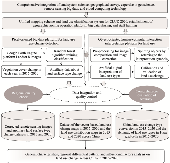
Figure 1 Flowchart on updating and mapping of land use change in China in 2015-2020
The primary data source for CLUD 2020 development is the Operational Land Imager (OLI) sensor images carried by the Landsat 8 satellite, which maintains the spatial resolution equivalent to earlier versions of CLUD data. A variety of Chinese-produced multispectral images of very high resolution (such as Gaofen-2) were supplemented where high-quality OLI images were lacking and used for accuracy assessment for CLUD 2020. The pre-processed images were distributed to remote sensing staff who detected LUCC using an object-oriented analysis on a human-computer interaction platform. To assist object-oriented analysis for improving efficiency, remote sensing experts provided pixel-level datasets of normalized difference vegetation index (NDVI) trends (Dong et al., 2016), city boundaries (Kuang et al., 2021), and preliminary LUCC for 2015-2020 by coding in the Google Earth Engine platform. Integrating object- and pixel-oriented analysis enables more accurate production of LUCC data by using expert knowledge (e.g., the texture, forms, color, and neighbor change in an object) to correct errors in pixel-level analysis (e.g., pseudo-spectral information, confusion of conversion and transition in land use).
A feature of CLUD 2020 is a special upgrade of the land use category system. Land for photovoltaic power generation (a second-level type, No. 54) has been added as an independent type in the built-up land (a first-level type, No. 50) based on field survey and expert knowledge, reflecting the prevalent distribution of land use in China. The quality of the entire data needed coordination due to splitting the whole update into regional assignments for corresponding institutes. The headquarters thus has ensured the accuracy and availability of CLUD 2020 by assessing the quality of regional data twice independently at the province level and providing the assessment to the responsible institutes for improvement. Thereafter, headquarters processed the regional data through integration, registration, and scale conversion and merged them into national-scale data for overall accuracy assessment. The final CLUD 2020 includes a 1:100,000 feature map that contains the land use distribution in 2020 and its change in 2015-2020, as well as 1-km resolution raster data that contains the land use type fractions in 2020 (Figure 2).
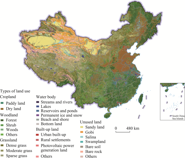
Figure 2 National land use pattern map of China in 2020

Note: The map is based on standard map No. GS (2019)1823 downloaded from the service website of standard maps, National Administration of Surveying, Mapping and Geoinformation, with no changes in the base map.

2.2 Accuracy assessment

The accuracy assessment of CLUD 2020 followed the established method to ensure the comparability of the multi-year CLUD data. Sufficient validation data, including survey records, live photos, and remotely sensed images, were acquired from fieldwork and onboard sensors with very-high-resolution (e.g., Google Earth, unmanned aerial vehicles, and Gaofen-2). Approximately 10% of the validation data was used by stratified random sampling at the national scale, with a 10:1 ratio of the changed patches to unchanged ones (Figure 3). The accuracy was assessed by quantitatively comparing the ground truth of validation data to the classified types from CLUD data in corresponding locations (Liu et al., 2003). Specifically, the assessment used the confusion matrix and generated four quantitative indicators, including User’s Accuracy (UA), Producer’s Accuracy (PA), Overall Accuracy (OA), and Kappa coefficient (Stehman, 2009; Congalton et al., 2019; Zhan et al., 2021).
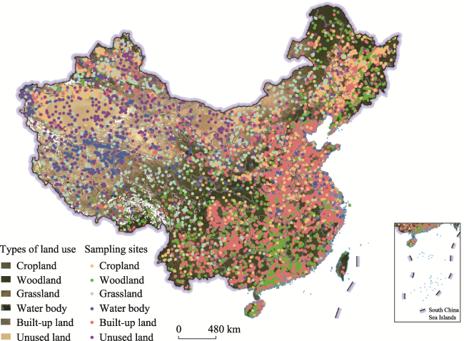
Figure 3 Distribution of sampling sites used for accuracy assessment of CLUD 2020

Note: The map is based on standard map No. GS (2019)1823 downloaded from the service website of standard maps, National Administration of Surveying, Mapping and Geoinformation, with no changes in the base map. The base map was a MODIS imagery generated in 2020.

A total of 19,040 independent sampling sites were used for assessment, of which 17,454 were for changed patches, and 1586 were for unchanged patches. More specifically, there were 6203, 1155, 1352, 1926, 7816, and 588 samples used for assessing the accuracy of cropland, woodland, grassland, water body, built-up land, and unused land, respectively. The assessment result shows that the OA of the first-level land use/cover category of CLUD 2020 was 95.53% (Kappa of 0.937), with cropland, woodland, and unused land all above 96% (Table 1). These indicators show that the CLUD 2020 data substantially agreed with the ground truth, indicating a robust availability.
Table 1 Confusion matrix of the accuracy of the first-level classification from CLUD 2020
The first level Sample size Number of
classified
samples
User’s
accuracy
(%)
Cropland Woodland Grassland Water
body
Built-up
land
Unused
land
Number of classified samples Cropland 5990 22 97 21 26 47 6203 96.57
Woodland 15 1123 3 3 0 11 1155 97.23
Grassland 27 2 1292 17 1 13 1352 95.56
Water body 34 1 30 1836 4 21 1926 95.33
Built-up land 294 58 43 20 7382 19 7816 94.45
Unused land 18 0 3 2 0 565 588 96.09
Sample size 6378 1206 1468 1899 7413 676 19040 -
Producer’s accuracy (%) 93.92 93.12 88.01 96.68 99.58 83.58 Overall accuracy (%) 95.53

2.3 Analysis of land use change

The patterns of LUCC in China from 2015 to 2020 were systematically delineated through three analyzing aspects, including the overall change of land use/cover, its regional differences, and the changes in national primary land use types. Further, in the corresponding three aspects, the differences between 2015-2020 and 2010-2015 were analyzed to reveal the features of LUCC and the development statuses of territorial land resources in the new era. On the basis of these analyses, the major drivers of LUCC in China have also been fully clarified.
The land use distribution and its change characteristics were independently analyzed within the seven geographic zones in China (i.e., North, Northeast, East, Central, South, Northwest, and Southwest) for the spatial differences of LUCC and its influencing factors. In addition, the spatial analyzing method was used to facilitate the identification and understanding of the primary patterns of national LUCC. The method analyzed the most predominant land use types and their areal changes within 10-km grids, which visualized the primary LUCC features for both temporal and spatial dimensions. The identified primary features include conversions from dry land to paddy land, and cropland to woodland/grassland, the expansion of water body, the expansion of built-up land, and the mutual conversion between woodland/grassland and cropland (Liu et al., 2010).

3 General characteristics of land use change in China

The total area of land use change in China in 2015-2020 was 450.35×10⁴ ha (square hundred meter), accounting for 0.47% of the total terrestrial area. Within the first-level land use type, the area of built-up land and water body increased by 200.40×10⁴ and 11.41×10⁴ ha, respectively. Conversely, the areal extent of cropland, grassland, and woodland decreased by 65.12×10⁴ ha, 64.80×10⁴ ha, and 25.25×10⁴ ha, respectively (Table 2).
Table 2 Land use conversion matrix across China during 2015-2020 (104 ha)
2015 2020
Cropland Woodland Grassland Water body Built-up land Unused land Total
Cropland - 6.31 26.92 9.94 142.08 5.19 190.44
Woodland 6.39 - 0.54 1.31 28.80 0.51 37.55
Grassland 60.30 3.03 - 13.73 23.26 3.29 103.61
Water body 16.80 0.90 5.30 - 6.63 4.26 33.89
Built-up land 8.36 0.81 1.49 1.31 - 1.50 13.47
Unused land 33.47 1.25 4.56 19.01 13.10 - 71.39
Total 125.32 12.30 38.81 45.3 213.87 14.75 -
While the changing trend of first-level land use type for 2015-2020 remained consistent with 2010-2015, the patterns of regional divergence changed in relation to diverse policies announced during the 13th Five-Year Plan (2016-2020). Compared to 2010-2015, the general characteristics of land use change in 2015-2020 are: (1) The aggregation of built-up land expansion has transited from coastal areas, megacities, and large cities to the surroundings of cities and towns in Central and Western China. (2) Cropland continued to be encroached by built-up land expansion nationwide. In Northeast China, the conversion area of dry land to paddy land decreased, and its hotspots shifted from the Sanjiang Plain to the Songnen Plain. In Xinjiang, Northwest China, cropland was generally reclaimed in the south but was reduced and abandoned in the north. (3) Woodland changed slightly, with a feature of wide distribution nationwide, the comparison shows that the concentration of woodland change was mainly found in the natural forest region of South China. (4) Grassland continued to shrink in North and South China and interconverted with cropland in Northwest China, built-up land encroachment on grassland was concentrated in Ningxia, Gansu, and Guizhou provinces; conversion from grassland to cropland distributed in the oasis agricultural region of Xinjiang and the Horqin region of Inner Mongolia. (5) Water body separately increased and decreased in West (e.g., Qinghai-Tibet Plateau) and East China (e.g., coastal areas and Northeast China) (Figure 4).
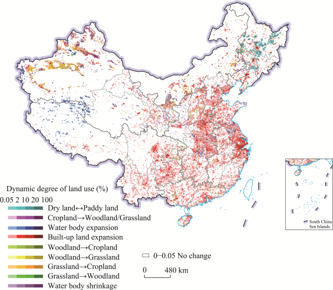
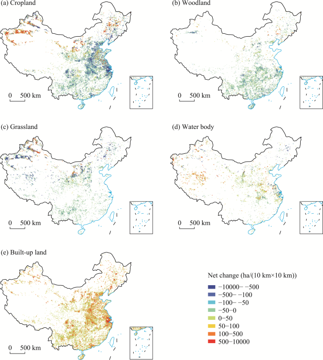
Figure 4 Distribution of dominant land use type conversion in China during 2015-2020

Note: The map is based on standard map No. GS (2019)1823 downloaded from the service website of standard maps, National Administration of Surveying, Mapping and Geoinformation, with no changes in the base map.

The features of land use conversion varied obviously across the seven geographic zones. In Northeast China, the primary features were the interconversion of dry land and paddy land and the built-up land expansion, with their areas being 49.55×10⁴ ha and 22.05×10⁴ ha, respectively. In North China, the primary features were the built-up land expansion and the conversion of grassland to cropland, with their areas being 29.61×10⁴ ha and 11.57×10⁴ ha, respectively. In both Central and South China, the dominant features were built-up land expansion, with areas of 32.98×10⁴ ha in the former and 17.71×10⁴ ha in the latter. In Northwest China, the conversions were complex, and the features included built-up land expansion (27.15×10⁴ ha), water body growth (23.19×10⁴ ha), reduction of cropland to woodland/grassland (22.55×10⁴ ha), and reclamation of grassland (43.75×10⁴ ha). In Southwest China, the area of built-up land and water body increased by 25.52×10⁴ ha and 8.67×10⁴ ha, respectively. In summary, the expansion of built-up land was consistent across the seven zones, despite differences in the characteristic and intensity of the land use conversion. Also, the dynamics of cropland types, including dry land and paddy land, were more significant in Northwest and Northeast China.
The individual type of land use conversion generated the pattern of spatial aggregation from 2015 to 2020. While built-up land expanded continually in all the geographic zones, East China (58.85×10⁴ ha) accounted for 27.52% of the total expansion. The conversion of cropland into built-up land mainly occurred in East and Central China, with the combined areas accounting for 51% of the total area of this type across all zones. Reclaimed cropland was mainly converted from grassland, and Northwest China accounted for 72.55% of the total area nationwide, with the aggregation being more significant in the oasis region of Xinjiang and Inner Mongolia. Also, the increase in water body was concentrated in Northwest and Southwest China, occurring mostly in the north of the Qinghai-Tibet Plateau (Table 3 and Figure 4).
Table 3 Land use types conversion matrix in different zones of China during 2015-2020 (104 ha)
Zone in China Dry land ↔Paddy land Cropland→
Woodland/
Grassland
Water body expansion Built-up land expansion Woodland

Cropland
Woodland

Grassland
Grassland

Cropland
Grassland →
Woodland
Water body shrinkage
Northeast 49.55 3.74 0.61 22.05 0.56 0.13 3.56 0.55 4.33
North 1.64 4.84 2.91 29.61 1.11 0.19 11.57 1.59 1.59
East 0.72 1.14 5.50 58.85 0.58 0.03 0.79 0.13 11.31
South 0.02 0.25 0.38 17.71 1.06 0.04 0.06 0.05 0.05
Central 0.26 0.42 4.04 32.98 0.28 0.01 0.01 0.17 0.41
Northwest 0.01 22.55 23.19 27.15 2.23 0.12 43.75 0.41 8.41
Southwest 0.00 0.30 8.67 25.52 0.58 0.02 0.56 0.12 1.08
Total 52.20 33.24 45.30 213.87 6.40 0.54 60.30 3.02 27.18
The intensity of land use change varied from 2010-2015 to 2015-2020. The net increase in built-up land expansion decreased from 246.82×10⁴ ha in 2010-2015 to 200.40×10⁴ ha in 2015-2020 nationwide. Nonetheless, the rate of urbanization accelerated slightly, i.e., the area of urban built-up land increased by 89.05×10⁴ ha in 2015-2020, higher than in 2010-2015 (84.74×10⁴ ha), indicating that the decrement in rural settlements, industrial and mining land, and transportation land was responsible for the general slowdown in the built-up land expansion during the investigation period. The reduction of cropland area sped up in China from 2015 to 2020 as the reclamation of cropland was offset by more loss. Specifically, China’s net loss of cropland area increased from 49.01×10⁴ ha in 2010-2015 to 65.12×10⁴ ha in 2015-2020. In addition, the shrinkage degree of woodland and grassland was lower in 2015-2020 than the previous five years (Figure 5).
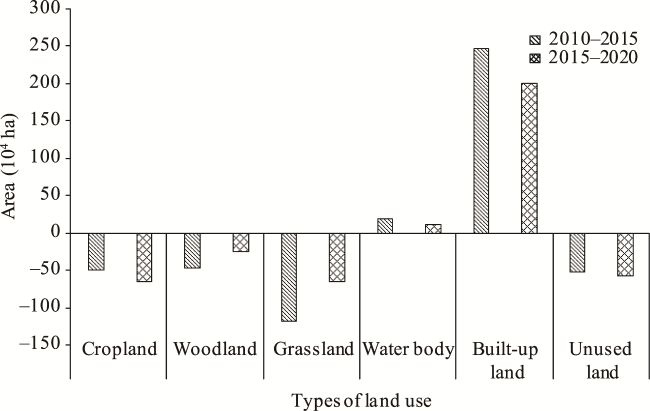
Figure 5 Comparison of area changes in dominant land use types in China between 2010-2015 and 2015-2020
As for the geographic zones, the spatiotemporal characteristics of land use change also varied between two temporal periods. In Northeast China, although the conversion from dry land to paddy land continued, its degree slowed, and its spatial hotspots shifted from the Sanjiang Plain to the Songnen Plain from 2010-2015 to 2015-2020. In the coastal region of Southeast China, the built-up land kept expanding, although slower in 2015-2020 compared to 2010-2015, with obvious expansion in city clusters, metropolises areas, and small-size cities. In Central China, the built-up land kept expanding, and the increase in water body was accelerating compared to 2010-2015. In Southwest and Northwest China, the expansion of built-up land always aggregated in regional economically-developed areas, such as the Sichuan Basin and Guanzhong urban agglomeration in 2010-2020. In addition, the oasis agricultural region of Xinjiang still acted as the key area for orderly ecological restoration of the oasis farming resource, depending on available water resources in Northwest China. The area of rivers and lakes further increased in the Qinghai-Tibet Plateau (Figures 4 and 5).

4 Regional differentiation of land use change across China

4.1 Regional characteristics of land use change in 2015-2020

While significant expansions of built-up land occurred for all the geographic zones, the expansion sources were inconsistent. In East, Southwest, Northeast, Central, and North China, the built-up expanded primarily by the encroachment on high-quality cropland, especially obvious in the southeastern coastal areas and the Sichuan Basin of Southwest China. Also, the expanded built-up land occupied more than 80% of the high-quality cropland in Northeast and East China, compared to above 70%, above 60%, and above 60% in the Central, Southwest, and North zones, respectively. The expansion sources of built-up land were slightly different in South and Northwest China. The expansion in South China encroached on above 50% of the cropland and above 42% of the woodland. In Northwest China, the expanded built-up land primarily encroached on unused land (above 35%) and grassland (above 34%).
The diversity of land use change across the geographic zones could be observed in addition to the built-up land expansion. Land reclamation was featured from Inner Mongolia of North China. The interconversion between dry land and paddy land was a main feature from the Sanjiang Plain and Songnen Plain in Northeast China. Land reclamation, cropland abandonment, and “Grain for Green” all existed in the drought and oasis agricultural regions of Northwest China. “Grain for Green” also occurred in North China. Besides, the conversion to rivers and lakes from cropland happened in areas with dense lakes/rivers in East and Central China. The conversion from grassland/unused land to water body was dominant in Northwest China and the Qinghai-Tibet Plateau of Southwest China.

4.2 Comparison of land use pattern between 2010-2015 and 2015-2020

The land use change across China in 2010-2015 and 2015-2020 were highly consistent in spatial distribution. However, the intensity of land use changes in 2010-2015 was slightly higher than that in 2015-2020, with identified regional features of the primary shifted type in the land use change in certain areas (Tables 4 and 5).
Table 4 Comparison of land use changes in different zones of China between 2010-2015 and 2015-2020 (104 ha)
Zone in
China
2010-2015 2015-2020
Cropland Woodland Grassland Water body Built-up land Unused
land
Cropland Woodland Grassland Water body Built-up land Unused
land
Northeast 5.02 -4.29 -2.76 -0.07 10.39 -8.29 -6.99 0.49 -3.49 -4.19 21.74 -7.52
North -12.76 1.30 -8.64 1.74 40.41 -15.85 -8.06 0.01 -14.91 0.57 25.82 -3.44
East -65.04 -9.35 1.71 5.39 67.74 -0.10 -33.78 -4.11 -2.72 -9.43 50.41 -0.13
South -10.59 -13.05 3.17 -0.35 20.77 0.04 -8.17 -8.33 -0.91 -0.06 17.44 0.03
Central -25.74 -10.12 -1.45 0.71 33.54 0.00 -28.74 -5.23 -1.53 2.72 32.64 0.11
Northwest 88.07 -3.37 -99.73 5.88 42.59 -28.74 35.52 -1.49 -32.32 14.36 26.90 -43.16
Southwest -27.97 -8.43 -10.01 5.37 31.38 1.48 -14.90 -6.59 -8.92 7.44 25.45 -2.53
Total -49.01 -47.31 -117.71 18.67 246.82 -51.46 -65.12 -25.25 -64.80 11.41 200.40 -56.64
Table 5 Regional characteristics and comparison of land use changes across China between 2010-2015 and 2015-2020
Zone in China Area
(106 ha)
2010-2015 2015-2020 Spatial differences
Northeast 78.79 Dominated by conversion from cropland to built-up land (about 8×10⁴ ha) and from unused land to cropland (about 6×10⁴ ha), followed by conversion from woodland/grassland to cropland (about 4×10⁴ ha) Dominated by conversion from cropland to built-up land (about 18×104 ha) and from unused land to cropland (about 7×10⁴ ha ), followed by conversion from water body/grassland to cropland (about 4×10⁴ ha) The primary land use change types changed with more cropland converted to built-up land, more water body converted to cropland, less woodland converted to cropland, the area of converted paddy land being further reduced, and the spatial dimension transferring from the Sanjiang Plain to the Songnen Plain and the junction between the two plains.
North 155.51 Dominated by conversion from cropland to built-up land (about 17×104 ha), followed by the conversion from grassland to built-up land (about 16×104 ha) Dominated by conversion from cropland to built-up land (about 18×104 ha), followed by conversion from grassland to built-up land (about 12×104 ha) The primary land use change types remained unchanged. The area converted from grassland to built-up land shrank by 25%. Spatially, for ecological restoration, the conversion from cropland to woodland further shrank, while the area of cropland reclamation increased slightly.
East 79.54 Dominated by conversion from cropland to built-up land (about 64×104 ha), followed by conversion from cropland to water body and from woodland to built-up land (about 8×10⁴ ha) Dominated by conversion from cropland to built-up land (about 48×104 ha), followed by conversion from cropland to water body (about 11×104 ha) The primary land use change types changed. The area of cropland converted to built-up land shrank by 25%. The area of woodland converted to built-up land decreased. Spatially, urban development encroaching on high-quality cropland slowed down.
South 44.78 Dominated by conversion from cropland to built-up land (about 11×104 ha), followed by conversion from woodland to grassland/ built-up land (about 8×10⁴ ha) Dominated by conversion from cropland to built-up land (about 9×10⁴ ha), followed by conversion from woodland to built-up land (about 8×10⁴ ha) The primary land use change types changed. The area of cropland converted to built-up land shrank. The area of woodland converted to built-up land remained unchanged. Spatially, deforestation and forest disturbance slowed down.
Central 56.47 Dominated by conversion from cropland to built-up land (about 24×104 ha), followed by conversion from woodland to built-up land (about 10×104 ha) Dominated by conversion from cropland to built-up land (about 26×104 ha), followed by conversion from woodland to built-up land (about 5×10⁴ ha) The primary land use change types remained unchanged. The area converted from cropland to built-up land increased. The woodland converted to built-up land decreased by 50%. Spatially, urban development encroaching on high-quality cropland grew slightly.
Northwest 308.26 Dominated by conversion from grassland to cropland (about 87×104 ha), followed by conversion from unused land to cropland (about 26×104 ha) Dominated by conversion from grassland to cropland (about 44×104 ha), followed by conversion from unused land to cropland (about 22×104 ha) The primary land use change types remained unchanged, while the area of land use change shrank. The area converted from grassland to cropland decreased by 50%. The area of unused land converted to cropland decreased. Spatially, there was a differentiation characteristic that reclamation in southern Xinjiang and de-farming/ abandonment in northern Xinjiang coexisted.
Zone in China Area
(106 ha)
2010-2015 2015-2020 Spatial differences
Southwest 236.65 Dominated by conversion from cropland to built-up land (about 24×104 ha), followed by conversion from unused land/grassland to water body (about 6×10⁴ ha) Dominated by conversion from cropland to built-up land (about 16×104 ha), followed by conversion from woodland to built-up land (about 6×10⁴ ha) and from grassland to water body (about 5×10⁴ ha) The primary land use change types changed. The area converted from cropland to built-up land decreased by one-third. The area of water body converted to unused land shrank dramatically. The area of woodland converted to built-up land increased, while the area of grassland converted to water body decreased. Spatially, the water body in the Qinghai-Tibet Plateau expanded significantly.
The net increment in built-up land across China in 2015-2020 (200.40×10⁴ ha) was lower than in 2010-2015 (246.82×10⁴ ha), and its primary source after 2015 was the growth of small cities, urban clusters, and metropolitan areas ongoing from 2010. As for regional features, from 2010-2015 to 2015-2020, the net increment of built-up land decreased by 35.25×10⁴ ha in the economically-developed zones, including North, East, and South China. In Northeast China, the economic revitalization zone, the net increment in built-up land increased by 11.35×10⁴ ha. In Northwest and Southwest China, the ecological security and protection zones, the net increment of built-up land decreased by 21.62×10⁴ ha.
The variation of cropland was more significant, with a continuous reduction from 2010 to 2020 but a higher net decrement in 2015-2020 than in 2010-2015. Large amounts of high-quality cropland were converted to built-up land in North China, East China, and Central China, as well as in the Huang-Huai-Hai region, the Yangtze River Delta, and the Pearl River Delta of South China. Cropland shifted from increment to decrement from 2010-2015 to 2015-2020 in Northeast China, with the ongoing interconversions between dry land and paddy land for ten years. The reclamation of cropland concentrated in Northwest China, but the area of grassland converted to cropland decreased by 50% in the oasis agricultural areas in Northwest China.
The area of woodland and grassland converted to cropland declined dramatically from 2010-2015 to 2015-2020, with the net loss dropping by 45% (from 165.02×10⁴ ha to 90.05×10⁴ ha). The gain in grassland was still aggregated in Inner Mongolia of North China and the oasis agricultural area in Xinjiang of Northwest China. The area of interconversion between grassland and woodland decreased substantially in South China. The total proportion of the conversion from woodland/grassland to built-up land decreased from 28% in 2010-2015 to 24% in 2015-2020.
The area of water body showed a growing trend, while the net increment of water body area dropped from 18.67×10⁴ ha in 2010-2015 to 11.41×10⁴ ha in 2015-2020. The water body area shifted from increment to decrement from 2010-2015 to 2015-2020 in East China, whereas, the growth of water body accelerated in Central, Northwest, and Southwest China. Among them, the conversion from cropland to rivers or lakes contributed to the expansion of water body in Central China. In Northwest and Southwest China, the growth primarily concentrated in the Qinghai-Tibet Plateau, with a growth rate of 94% from 2015 to 2020.
Unused land, as a crucial reserve resource for land use in China, decreased with a consistent trend from 2010 to 2020, with the net loss increasing by 5.18×10⁴ ha in 2015-2020. The resulting land use type converted from unused land became more diverse after 2015. Specifically, unused land mainly converted to built-up land (47%) and cropland (18%) from 2010 to 2015, while it went to cropland (33%), grassland (21%), water body (24%), and built-up land (18%) from 2015 to 2020. Northwest China had a large amount of unused land. With increasing state-level development and the exploitation of unused land, the proportion of unused land loss in Northwest China to the national total decreased from 71% in 2010-2015 to 60% in 2015-2020. The utilization of unused land was no longer solely for cropland reclamation and built-up land-it was also used to enhance the ecosystem services and ecological functions.

5 Change characteristics of dominant land use types in China

5.1 Changes in cropland in 2015-2020

The general trend of cropland changes was characterized by an expansion in the north part of China and a shrinkage in the south part of China in 2015-2020, with its primary change types as encroachment, reclamation, de-farming, and abandonment. In Northwest China, the reclamation occurring in southern Xinjiang coexisted with de-farming/abandonment in northern Xinjiang. The cropland area sharply decreased in East (33.78×10⁴ ha) and Central China (28.74×10⁴ ha). The loss of cropland was primarily due to the built-up land encroachment, as an average of 74.61% of lost cropland was converted to built-up land, with more than 90% in East, South, and Southwest China. The Yangtze River Delta, the Pearl River Delta, and the Sichuan Basin were the hotspots of conversion from cropland to built-up land. In comparison, 68.12% of the cropland was transformed into woodland/grassland in Northwest China under the continuous policies regarding cropland reduction and ecological oasis construction (Figures 4 and 6a).
The cropland area increased in certain areas owing to the exploitation of reserve cropland resources. The development of unused land and oasis agriculture primarily promoted the increase of cropland area under the trinity strategy aimed at protecting the quality, quantity, and ecology of cropland. The area of conversion from grassland to cropland in the Tarim Basin of Xinjiang was the largest in China, making Northwest China the only zone where cropland increased (by 35.52×10⁴ ha). Also, in the Songnen Plain of Northeast China, the Junggar Basin of Northwest China and the Hetao Plain of North China, the proportions of woodland/grassland converted to cropland were 26.04%, 66.95%, and 68.03%, respectively (Figure 6a).
Figure 6 Land use change area of main types in China during 2015-2020

Note: The map is based on standard map No. GS (2016)1603 downloaded from the service website of standard maps, National Administration of Surveying, Mapping and Geoinformation, with no changes in the base map.

Urbanization was the major driver of cropland loss. The area of urban expansion increased from 84.74×10⁴ ha in 2010-2015 to 89.05×10⁴ ha in 2015-2020, of which 64.46% came from cropland. Correspondingly, new cropland was reclaimed in southern Xinjiang of Northwest China, and North and Northeast China to replenish the cropland to a sufficient amount nationwide.

5.2 Changes in woodland and grassland in 2015-2020

Cropland reclamation and expansion of construction land were the major contributors to the loss of grassland and woodland in 2015-2020. Specifically, the area of woodland and grassland reduced by 137.59×10⁴ ha, of which 52.06×10⁴ ha was converted to built-up land and 66.69×10⁴ ha was converted to cropland. The dramatic loss of woodland and grassland aggregated in North and Northwest China, accounting for 54.09% of total losses in China (Table 2, Figures 6b to 6c).
The woodland conversion was generally weak but widely distributed in, e.g., the eastern part of Southwest China and East, Central, and South China. Also, the proportion of woodland-related conversions to the national total of land use conversions was slight at 8.34% in 2015-2020. The area of woodland loss was 37.55×10⁴ ha, of which 76.7% has transformed into expanded built-up land. However, the conversion speed from woodland to built-up land decreased from 6.93 km2/yr in 2010-2015 to 5.76 km2/yr in 2015-2020. The spatial distribution of woodland gain was sparse and was converted primarily from cropland/grassland distributed in the Junggar Basin of northern Xinjiang (Figure 6b).
The net loss of grassland accounted for 103.61×10⁴ ha from 2015 to 2020 in China, larger than that of woodland. However, similar to the trend in woodland, grassland loss decreased from 23.54×10⁴ ha/yr in 2010-2015 to 12.96×10⁴ ha/yr in 2015-2020. As for the loss of grassland, 58.2% and 22.45% were converted to the cropland and built-up land, respectively, with the former aggregated in Xinjiang and the Horqin region of Inner Mongolia, and the latter aggregated in the Ningxia, Guizhou, and southern Gansu (Figure 6c).
As essential land use types for ecological protection, woodland and grassland played a vital role in ecological functions in terms of wind break, sand fixation, and water/soil conservation. Since 2000, the Conversion of Cropland to Forest/Grassland Program, also known as the “Grain for Green”, has been implemented extensively in China. Correspondingly, the conversion intensity from cropland to woodland/grassland reached its peak, making the area of woodland and grassland turn to a decrease. These policies attributed the decrease in loss intensity of woodland and grassland after 2015 to ecological policies such as improving the political mechanism of grassland protection and developing the management system for woodlands and grasslands.

5.3 Changes in water body in 2015-2020

The area of water body increased by 45.30×10⁴ ha in China in 2015-2020. The growth of water body primarily gained from the contribution of unused land (41.97%) as well as grassland (30.31%) and cropland (21.94%) that were transformed into water body (Table 2). Among the geographic zones, Northwest and Southwest China aggregated the largest proportion of this growth. Specifically, with an increment of 23.19×10⁴ ha, Northwest China accounted for 51.19% of total water body growth nationwide, followed by Southwest China, with an increment of 8.67×10⁴ ha (Table 3). The growth of water body in Northwest and Southwest China was found in the junction of the first and second steps of China (e.g., near regions of the Kunlun Mountains and Qilian Mountains) and the Tianshan Mountains area of central Xinjiang. In addition, the water body area decreased by 33.89×10⁴ ha in China, concentrated in East, Northwest, and Northeast China. East China contributed the most water body loss at 15.05×10⁴ ha, accounting for 44.41% of the nation’s total loss (Figure 6d).
Both the increase and shrinkage of water body area has an obvious divergence in 2015-2020 in comparison to 2010-2015. Moreover, the changes in water body exhibited spatial heterogeneity regarding area and speed across the geographic zones in 2015-2020. In terms of the total change area in 2015-2020, Southwest China accounted for the largest increase in water body area, while East China, South China, and Northeast China experienced significant decreases. Especially in East China, which showed growth in 2010-2015, the water body area appeared to have the most severe loss in 2015-2020 (Table 4 and Figure 6 d). In addition to human activity, climate change was responsible for such changes in water body in China in 2015-2020, such as the contribution of melted snow could contribute to the growth of water body in the Qinghai-Tibet Plateau under global warming. Studies have shown that although precipitation acted as the primary driver, the melting of snow and frozen soil separately contributed 20.5%-45.5% and 2.1%-6.7% to the growth of 10 large lakes in the Qinghai-Tibet Plateau (Zhou et al., 2021).

5.4 Changes in built-up land in 2015-2020

The area of built-up land in China, consisting of urban and rural construction land, industrial and mining activities, and transport systems, increased by 200.40×10⁴ ha in 2015-2020. The conversion of cropland contributed the most to the total expansion of built-up land with 66.43%, followed by the conversion of woodland and grassland with 13.47% and 10.88%, respectively. Among the geographic zones, East China contributed the most with 50.41×10⁴ ha, accounting for 25.15% of the national increment, followed by Central China with 32.64×10⁴ ha. In contrast, South China contributed the smallest part of the national increment at 17.44×10⁴ ha. In East China, the built-up land expansion was observed in economically developed areas such as the Yangtze River Delta and the surroundings of cities and towns in the Shandong Peninsula. In Central China, such expansions were distributed in urban clusters within the middle reaches of the Yangtze River and the central plain. The expansion of built-up land occurred around urban areas in Northeast China, such as Harbin, Changchun, and Shenyang (Figure 6e).
Although the nation’s total built-up land expansion declined after 2015, the expanded area and its speed varied significantly across the geographic zones compared to 2010-2015. Except for Northeast China, which showed the more built-up land expansion than in 2010-2015, other zones showed a decrease in such expansions. Compared to 2010-2015, the decrease in built-up land expansion was 17.33×10⁴ ha, 15.69×10⁴ ha, and 14.59×10⁴ ha in East, Northwest, and North China, respectively, in 2015-2020. In general, the expansion of built-up land was centered in East China and spread to large-, medium- and small-sized cities in the west part of China from 2015 to 2020 (Figure 6e).
Increasing residents and land demands drove such expansions. The statistic shows that with an increase in urban population from approximately 771.11×10⁶ in 2015 to 901.99×10⁶ in 2020, China’s urbanization rate has increased from 56.10% to 63.89% (NBSC, 2021). Thus, to satisfy the land use demand for manufacturing, living, and ecological protection plus the demand of land use for mining and transportation, built-up land continued to expand in 2015-2020.

6 Conclusions

China’s Land Use/cover Dataset for 2020 (CLUD 2020) was updated by integrating remote sensing big data and an object-oriented human-computer interaction interpretation method. The applied integrating method has improved the efficiency of human-computer interpretation and the accuracy of the nation’s land use change detection, with an overall accuracy of the first level category of CLUD 2020 up to 95.53% and exceeded the data for previous mapping years.
The patterns and process of land use change in 2015-2020 were revealed based on CLUD 2020 during the 13th Five-Year Plan of China. We found that the intensity of national land resource exploitation in 2015-2020 entered a relatively stable stage compared to 2010-2015. Encroached by built-up land nationwide, the area of cropland has been on a decline since 2000. Although the increase in the built-up land in 2015-2020 was less than that in 2010-2015, urban expansion was still accelerated. As for the natural land, the areas of woodland and grassland continued being reduced but to a lesser intensity in 2015-2020, compared to 2010-2015.
Attributing to the 13th Five-Year Plan that leads China to enter a new era, the corresponding aims of improving development quality and ecological civilization construction significantly influenced the nation’s patterns of land use change, driving the changing intensity to become stable in 2015-2020. The regional intensity of land use change was also well-planned and controlled, with diminished dramatic changes. Nevertheless, the challenges in ecological conservation still should be highlighted in Northwest, North, and Southwest China. Enhancing the control of land exploitation and environmental pollution is still crucial to constructing an ecological civilization during the new era. In this regard, CLUD, contains long-term information on the nation’s land use change from the late 1980s to 2020, can strongly support territorial planning, ecological civilization construction, and the goal-setting of the “Beautiful China” initiative.

We thank the CLUD 2020 interpretation team for their contribution to data collection, as well as the anonymous reviews’ comments.

[1]
Congalton R G, Green K, 2019. Assessing the Accuracy of Remotely Sensed Data:Principles and Practices. Boca Raton: CRC Press.

[2]
Creutzig F, 2017. Govern land as a global commons. Nature, 546(7656): 28-29.

DOI

[3]
Dong J W, Xiao X M, Menarguez M A et al., 2016. Mapping paddy rice planting area in northeastern Asia with Landsat 8 images, phenology-based algorithm and Google Earth Engine. Remote Sensing of Environment, 185, 142-154

DOI PMID

[4]
Foley J A, DeFries R, Asner G P et al., 2005. Global consequences of land use. Science, 309(5734): 570-574.

PMID

[5]
Future Earth, 2013. Future Earth Initial Design:Report of the Transition Team. Paris: International Council for Science.

[6]
Gao L, Bryan B A, 2017. Finding pathways to national-scale land-sector sustainability. Nature, 544(7649): 217.

DOI

[7]
Global Land Programme(GLP), 2016. Science plan and implementation strategy, https://www.glp.earth/our-science/science-plan

[8]
Grimm N B, Faeth S H, Golubiewski N E et al., 2008. Global change and the ecology of cities. Science, 319(5864): 756-760.

DOI PMID

[9]
He C Y, Zhang J X, Liu Z F et al., 2022. Characteristics and progress of land use/cover change research during 1990-2018. Journal of Geographical Sciences, 32(3): 537-559.

DOI

[10]
InternationaI Geosphere Biosphere Programme (IGBP), 2005. Science plan and implementation strategy. Stockholm: IGBP Secretariat.

[11]
Kuang W H, 2020. 70 years of urban expansion across China: Trajectory, pattern, and national policies. Science Bulletin, 65(23): 1970-1974.

DOI

[12]
Kuang W H, Du G M, Lu D S et al., 2021. Global observation of urban expansion and land-cover dynamics using satellite big-data. Science Bulletin, 66(4): 297-300.

DOI

[13]
Kuang W H, Liu J Y, Tian H Q et al., 2022. Cropland redistribution to marginal lands undermines environmental sustainability. National Science Review, 9(1): 66-78.

[14]
Lambin E F, Baulies X, Bockstael N et al., 1999. Land-use and land-cover change: Implementation strategy. Stockhdm and Bonn: Scientific Steering Committee and International Project Office of LUCC.

[15]
Liu J Y, 1996. Macro-scale Survey and Dynamic Study of Natural Resources and Environment of China by Remote Sensing. Beijing: China Science and Technology Press.

[16]
Liu J Y, Kuang W H, Zhang Z X et al., 2014. Spatiotemporal characteristics, patterns, and causes of land-use changes in China since the late 1980s. Journal of Geographical Sciences, 24(2): 195-210.

DOI

[17]
Liu J Y, Liu M L, Tian H Q et al., 2005. Spatial and temporal patterns of China’s cropland during 1990-2000: An analysis based on Landsat TM data. Remote Sensing of Environment, 98(4): 442-456.

DOI

[18]
Liu J Y, Zhang Z X, Xu X L et al., 2010. Spatial patterns and driving forces of land use change in China during the early 21st century. Journal of Geographical Sciences, 20(4): 483-494.

DOI

[19]
Liu J Y, Zhang Z X, Zhang S W et al., 2020. Innovation and development of remote sensing-based land use change studies based on Shupeng Chen’s academic thoughts. Journal of Geo-information Science, 22(4): 680-687. (in Chinese)

[20]
Liu J Y, Zhang Z X, Zhuang D F et al., 2003. A study on the spatial-temporal dynamic changes of land-use and driving forces analyses of China in the 1990s. Geographical Research, 22(1): 1-12. (in Chinese)

[21]
Meyfroidt P, de Bremond A, Ryan C M et al., 2022. Ten facts about land systems for sustainability. Proceedings of the National Academy of Sciences of the United States of America, 119(7): e2109217118.

[22]
Moran E, Ojima D S, Buchmann B et al., 2005. Global land project: Science plan and implementation strategy. Stockholm: IGBP Secretariat. http://hdl.handle.net/102.100.100/180468?index=1

[23]
Nagendra H, Bai X, Brondizio E S et al., 2018. The urban south and the predicament of global sustainability. Nature Sustainability, 1(7): 341.

[24]
National Bureau of Statistics of China (NBSC), 2021. China Statistical Yearbook 2021. Beijing: China Statistics Press. (in Chinese)

[25]
Newbold T, Hudson L N, Arnell A P et al., 2016. Has land use pushed terrestrial biodiversity beyond the planetary boundary? A global assessment. Science, 353(6296): 288-291.

DOI PMID

[26]
Newbold T, Hudson L N, Hill S L L et al., 2015. Global effects of land use on local terrestrial biodiversity. Nature, 520(7545): 45.

DOI

[27]
Ning J, Kuang W H, Liu J Y et al., 2018. Spatiotemporal patterns and characteristics of land-use change in China during 2010-2015. Journal of Geographical Sciences, 28(5): 547-562.

DOI

[28]
Popp A, Humpenöder F, Weindl I et al., 2014. Land-use protection for climate change mitigation. Nature Climate Change, 4(12): 1095.

DOI

[29]
Pretty J, Benton T G, Bharucha Z P et al., 2018. Global assessment of agricultural system redesign for sustainable intensification. Nature Sustainability, 1(8): 441-446.

DOI

[30]
Seto K C, Golden J S, Alberti M et al., 2017. Sustainability in an urbanizing planet. Proceedings of the National Academy of Sciences of the United States of America, 114(34): 8935-8938.

DOI PMID

[31]
Seto K C, Güneralp B, Hutyra L R. 2012. Global forecasts of urban expansion to 2030 and direct impacts on biodiversity and carbon pools. Proceedings of the National Academy of Sciences of the United States of America, 109(40): 16083-16088.

DOI PMID

[32]
Steffen W, Richardson K, Rockström J et al., 2015. Planetary boundaries: Guiding human development on a changing planet. Science, 347(6223): 1259855.

DOI

[33]
Stehman S V, 2009. Sampling designs for accuracy assessment of land cover. International Journal of Remote Sensing, 30(20): 5243-5272.

DOI

[34]
Verburg P, Crossman N, Ellis E C et al., 2015. Land system science and sustainable development of the earth system: a global land project perspective. Anthropocene, 12: 29-41.

DOI

[35]
Zhan Q Q, Zhao W, Yang M J et al., 2021. A long-term record (1995-2019) of the dynamics of land desertification in the middle reaches of Yarlung Zangbo River basin derived from Landsat data. Geography and Sustainability, 2(1): 12-21.

DOI

[36]
Zhou J, Wang L, Zhong X Y et al., 2021. Quantifying the major drivers for the expanding lakes in the interior Tibetan Plateau. Science Bulletin, 67(5): 474-478.

DOI

Outlines

/