Special Issue: Disciplinary Structure and Development of Geographic Science

Disciplinary structure and development strategy of information geography in China

  • LI Xin , 1, 2 ,
  • YUAN Linwang 3 ,
  • PEI Tao 2, 4 ,
  • HUANG Xin 5 ,
  • LIU Guang 6 ,
  • ZHENG Donghai 1
Expand
  • 1.State Key Laboratory of Tibetan Plateau Earth System, Environment and Resources, Institute of Tibetan Plateau Research, CAS, Beijing 100101, China
  • 2.College of Resources and Environment, University of Chinese Academy of Sciences, Beijing 100049, China
  • 3.Ministry of Education Key Laboratory of Virtual Geographic Environment, Nanjing Normal University, Nanjing 210023, China
  • 4.State Key Laboratory of Resources and Environment Information System, Institute of Geographic Sciences and Natural Resources Research, CAS, Beijing 100101, China
  • 5.School of Remote Sensing and Information Engineering, Wuhan University, Wuhan 430079, China
  • 6.Key Laboratory of Digital Earth Science, Aerospace Information Research Institute, CAS, Beijing 100094, China

Li Xin, Professor, specialized in data integration and remote sensing of cryosphere. E-mail:

Received date: 2022-05-24

  Accepted date: 2022-06-12

  Online published: 2022-11-25

Supported by

National Natural Science Foundation of China(41988101)

Abstract

The advent of the information era has resulted in exceptional advances in geographic science. The domain of geographic science has expanded from traditional physical and human geography to physical, human, and information geography, resulting in the emergence of the field of information geography. Three subdisciplines have gradually formed, i.e., geographic remote sensing science, geographic information science, and geographic data science. With a view towards preparing a description of the disciplinary structure of geographic science for the “Development Strategy of Discipline and Frontier Research in China (2021-2035)”, this article summarizes the history, definition, and disciplinary structure of information geography. The strategic layout of the discipline, along with the goals and key directions of priority development fields, are also highlighted. The insights into this new discipline provided in this paper will promote the development and application of remote sensing and geographic information within the framework of geographic science, advancing the synthesis of geographic research and the integrated development of geographic science.

Cite this article

LI Xin , YUAN Linwang , PEI Tao , HUANG Xin , LIU Guang , ZHENG Donghai . Disciplinary structure and development strategy of information geography in China[J]. Journal of Geographical Sciences, 2022 , 32(9) : 1670 -1682 . DOI: 10.1007/s11442-022-2017-2

1 Formation of information geography

The context and conditions for the future development of geographic science have been dramatically changed by the rapid development and wide application of information science and technology, such as Earth observation, intelligent sensing, Internet of Things, big data, cloud computing, and artificial intelligence. The deep integration of information science and technology into geographic science has resulted in the emergence of information geography, endowing geographic science the features of technical science. The establishment and development of ‘space-air-ground’ integrated remote sensing observation, Internet of Things, and social sensing have enabled real-time dynamic acquisition and access to data and information related to various physical and human elements. Remote sensing and geographic information technologies have been major drivers in revolutionizing geographic science. The development of geographic data fusion and integration technologies, integrated geographic system models, and decision support systems has led to increasing reliance on integrated models and scenario-based prediction in information space for understanding the Earth’s surface system and optimizing decision-making in the real world. The development of technologies such as virtual reality, augmented reality, and digital twins has increasingly blurred the boundaries between the physical and virtual worlds, enabling multiple interactions among physical geographic space, human and social space, and information space. However, recent research in the field of geographic information has become excessively technically oriented towards information science, while becoming increasingly distanced from geographic science. Therefore, information geography must be urgently restructured to keep geographic science focused on serving the human-living environment and promote the integrated development of geographic science.
Information geography uses information technology as the main means to study distribution characteristics; spatial-temporal differentiation; and spatial connections among the physical, human, and geographic information elements in the Earth’s surface system (Li et al., 2022; Liu, 2022; Lü et al., 2022). Information geography also encompasses the collection, transmission, storage, expression, analysis, and application of geospatial data and information. Information geography is an emerging cross-cutting secondary discipline of geographic science that is deeply integrated with physical geography, human geography, and information science and technology. Information geography has a strong technical and scientific orientation and is a unique and indispensable component of geographic science (Chen et al., 2022). The main contributions of information geography to geographic science are summarized here. First, the incorporation of information geography has improved the disciplinary structure of geographic science by organically linking various branches of geographic science and facilitated the development of quantitative and scientific research dimensions through information means, enabling geographic science to achieve quantitative analysis not only for the past and present but also for future prediction. Second, information geography has enabled the introduction and integration of the latest advances in information science and other related disciplines, such as big data, artificial intelligence, and Internet of Things into geographic science. Consequently, the level of synthesis and integration of data and knowledge has been improved, and key tools have been provided for solving complex geoscientific problems and advancing understanding and modelling of the Earth’s surface system. Third, information geography provides a medium for physical geography, human geography, and social services that is useful for research fields that require results of geographic science research and thereby promotes regional and global sustainable development. Compared with traditional geographic information science and remote sensing, information geography is more focused on ‘geography’, which directs the development and application of remote sensing and geographic information science back towards geographic science (Table 1). Information geography is by no means a closed field but is continuously growing and serves as a stimulus for interactions among practitioners in the field. In this article, the disciplinary structure and development strategy of information geography is presented to stimulate discussion on how to improve and develop this discipline.
Table 1 Comparison of the concepts and definitions of information geography, geographic information science (GIScience), and remote sensing and GIScience
Discipline Pros Cons
Information
geography
Encompasses physical and human geography and unifies the technologies of geography (e.g., remote sensing, GIS, big geographic data, and surface Earth system modelling) Introduces the ambiguity of taking the spatial relationship of information as the research subject
GIScience Widely accepted Does not fully include either remote sensing or dynamic simulations of the Earth’s surface systems and mainly focuses on GIS and cartography
Remote sensing
and GIScience
Includes both remote sensing and GIScience This discipline has an overly long name; remote sensing not only falls under geographic science but also includes other disciplines such as remote sensor development and atmospheric and oceanic remote sensing

2 Subdisciplines of information geography

The rapid development of technologies such as remote sensing, geographic information, Internet of Things, big data, and artificial intelligence has been a major driver for the innovation of geographic science and facilitated the formation and development of information geography. Three subdisciplines have gradually formed: geographic remote sensing science, geographic information science, and geographic data science (Figure 1).
Figure 1 Disciplinary structure of information geography

2.1 Geographic remote sensing science

Remote sensing science and technology have been widely used in various branches of Earth system science and in many other fields, including ecology, environmental science, agriculture, forestry, transportation, and urban development. Geographic remote sensing science, as defined in this article, only refers to the fundamental scientific questions that arise from the intersection of remote sensing science and technology and geographic science and from the applications of remote sensing to various branches of geographic science (Figure 1).
The rapid development of remote sensing has provided both important information sources and scientific and technological support for the study of physical geography, human geography, sustainable development, and human-nature systems, and has promoted the development of fundamental remote sensing research such as quantitative inversion, remote sensing product validation, and scale transformation. Improvements in remote sensing radiative transfer modelling and quantitative remote sensing inversion theory based on a priori knowledge have facilitated development of the theory and method of synergetic inversion based on multisource remote sensing (Li et al., 2013; Li et al., 2016; Liang and Wang, 2019). The production of quantitative remote sensing products for the global land surface and the development of a synergetic inversion system based on multisource remote sensing data has enabled China to create long-time series global remote sensing products (Liang et al., 2021). The validation of quantitative remote sensing products has made great progress in the construction of relevant theories and methods. In particular, methods have been developed for acquiring ground truth at the remote sensing pixel scale, and the in situ networks have been constructed for validating remote sensing products. ‘Bottom-up inductive’ and ‘top-down deductive’ methods have been proposed for solving remote sensing scale problems (Li and Wang, 2013). Theory and experimental methods for remote sensing scale transformation have been gradually established through conducting the Heihe watershed allied telemetry experimental research (HiWATER) (Li et al., 2013).
Remote sensing science has been integrated into geographic science via the gradual formation of several major application branches, including vegetation remote sensing (Liu, 2014), land use/land cover remote sensing (Chen and Chen, 2018), geomorphological remote sensing, hydrological remote sensing, cryosphere remote sensing (Li et al., 2020a), and remote sensing of humanities and socioeconomic elements (Xu et al., 2016) (Figure 2). Geographic remote sensing science has thereby driven the development of geographic science to an unprecedented depth and breadth. Remote sensing has played an important role in mapping the 1:1,000,000 Chinese vegetation map and the national forest resource map. Chinese scientists have successively released the first global land cover datasets at resolutions of 30 meters and 10 meters (Chen and Chen, 2018; Gong et al., 2019b) and developed annual maps of global artificial impervious areas between 1985 and 2018 at a 30-m resolution and other high-resolution land cover products (Gong et al., 2020). Remote sensing and geographic information systems (GIS) technologies that integrate positioning and quantitative and qualitative methods have been used to compile the Geomorphological Atlas of the People’s Republic of China (Zhou and Cheng, 2010), thereby providing accurate key data for geomorphological research. The two-phase Heihe River remote sensing experimental project was completed over a 10-year span and has realized the deep integration of remote sensing with integrated eco-hydrological study (Li et al., 2013). In addition, remote sensing has also facilitated the quantitative assessment of the United Nations Sustainable Development Goals based on long-period, multiscale, macroscopic and microscopic information from multisource remote sensing observations and the usage of big Earth data (Guo, 2020).
Figure 2 Integration of remote sensing and geographic science

2.2 Geographic information science

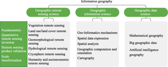
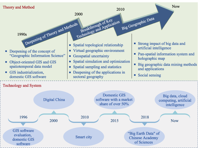
Geographic information systems (GIS) emerged in the 1960s, and Goodchild proposed the concept of geographic information science (GIScience) in 1992 (Goodchild, 1992). GIS was introduced to China in the late 1970s, and pioneering Chinese scientists, such as the academician Shupeng Chen, advocated for and introduced geographic information science research to China. These scientists proposed a series of concepts and methods, such as the ‘geographic information graph’, that facilitated the methodological development of geographic information science (Figure 3). From 1990 to 2000, Chinese scientists mainly conducted theoretical and methodological studies in the fields of GIS construction models, digital elevation analysis, vector-raster integrated spatiotemporal data models (Gong and Xia, 1999), object-oriented GIS (Gong, 1997), GIS-based spatiotemporal data models, and spatial statistics and analysis. A series of domestic GIS softwares with independent intellectual property rights, such as Super Map, MapGIS, and GeoStar, were developed. Since 2000, the in-depth study of geographic information science and demand for developing Digital Earth and Digital China has resulted in the increasingly intensive application of GIS, accompanied by methodological and technological innovations by Chinese scientists in the virtual geographic environment (Lü, 2011), spatial topological relations (Chen and Guo, 1998), geospatial statistics (Wang and Xu, 2017), geographic data mining, geospatial uncertainty, cellular automata and geographic simulation systems (Li et al., 2017), and geospatial prediction. Since 2010, the rapid development of smart city construction (Li et al., 2014; Gong et al., 2019a) has made GIS the fundamental support platform for urban management, land use, public health, disaster monitoring, and other applications. GIS platforms and related softwares in China have developed rapidly and independently. The market share of domestic GIS software exceeded 50% for the first time in 2015. Since 2018, outstanding progress has been made in the geographic information science in China in the fields of new information and communications technology (ICT), big geographic data (Pei et al., 2019), artificial intelligence, and ubiquitous geographic information services. A series of internationally prominent fundamental theories and key technologies have been developed, including full-space information systems (Zhou, 2015), panoramic maps (Zhou et al., 2011), geoscenography (Lü et al., 2018), and social sensing (Liu et al., 2015). China’s geographic information science efforts have led to remarkable progress in the fields of big Earth data integration (Guo, 2018) and behavioural trajectories and space. The development and application of geographic information science and technology have gone far beyond the scope of geographic science research, gradually moving from scientific research and industrial applications to public and social services.
Figure 3 Development history and key achievements of geographic information science over the past three decades

2.3 Geographic data science

The main research fields in geographic data science (Singleton and Arribas-Bel, 2021) are mathematical geography, big geographic data, machine learning, and artificial intelligence geography (Figure 1). Big data and artificial intelligence have driven the formation and development of geographic data science. Chinese scientists have developed mathematical geography methods that go beyond the scope of statistical methods, while incorporating machine learning, evolutionary methods, and complex network theories (Yuan et al., 2019). A variety of geographic data, such as Earth observations, sensor networks, volunteered geographic information (VGI), and human behavioural data, have rapidly converged into a series of massive geographic data resource pools. Consequently, a series of standards and specifications, data models, aggregation methods, transmission models, sharing models, and infrastructures have been established for big geographic data. This progress has enabled the seamless integration of GIS, remote sensing, global positioning systems (GPS), and spatial decision support systems (SDSS) along with improved scientific data integration and the sharing network for the Earth’s surface system (Chen et al., 2020; Li et al., 2020b). Chinese scientists have used massive Earth observation data and multisource fused data to build a large Earth data platform (Guo, 2018) that provides new methodologies for Earth science research and has provided extremely significant support for the United Nations Sustainable Development Goals (Guo, 2020) and the ‘Digital Belt and Road Initiative’ (Guo, 2018). Big data for human behaviour have been used to establish methods for analysing human spatiotemporal behaviour characteristics. A research framework for social sensing has thus been developed (Liu et al., 2015) that has triggered the development and breakthroughs of big social data. Traditional statistical methods are limited utility for exploring complex and nonlinear relationships, multivariate collaborative and spatiotemporal coupling features, and ultralarge-scale computations embedded in geographic data. Along with rapid developments in big geographic data, breakthroughs in artificial intelligence methods represented by deep learning have infused vitality into research on processing big data, whereby computational methods have been quickly developed. Chinese scientists have applied deep learning neural networks to process big data, such as remote sensing images, street view images, text data, and social media data, resulting in important breakthroughs. For example, deep learning has significantly outperformed traditional methods in the fusion of multisource information such as time series, space, spectrum, and semantics (Zhang and Luo, 2020).

3 Strategic layout for the disciplinary development of information geography

As the development of information geography is related to the holistic development of geographic science, a forward-looking strategic plan requires consideration of multiple aspects, including disciplinary structure design, fundamental theoretical research, key method development, integrated platform construction, and support for sustainable development and major national decision-making. First, fundamental research on information geography must be intensified, and a comprehensive disciplinary structure of information geography should be constructed based on a detailed consideration of core geographic science issues. Second, the results of cutting-edge research in the information field should be used to advance the development of key fundamental theories and methods for intelligent geographic analysis, big Earth data, comprehensive simulation of Earth surface systems and data assimilation. In addition, the big geographic data platform, Earth surface system modelling platform, and sustainable development decision support system should be established to consolidate the information infrastructure of geographic science. Third, the development and promotion of comprehensive application of information geography and integration of geographic data, information, knowledge, and decision-making will provide increased support for national and regional sustainable development.

3.1 Geographic remote sensing science

Tasks that must be accomplished for geographic remote sensing science include vigorous development of fundamental theories and methods, wide application of remote sensing to various branches of geographic science, development of basic geographic remote sensing products, and improving the capability of supporting geographic science and the United Nations Sustainable Development Goals. Future tasks include performing more studies on the mechanism of remote sensing, Earth surface system models, big Earth data methods, and the assimilation of remote sensing information into Earth surface system models. In particular, efforts should be focused on solving three major scientific challenges in geographic remote sensing science, i.e., quantitative remote sensing inversion, scale transformation, and remote sensing product validation, to realize major breakthroughs and discoveries in geographic science.

3.2 Geographic information science

Emerging information technologies can be embedded in geographic information science to develop geospatial cognition, expression, analysis, simulation, prediction, and optimization methods and to explore methods for mapping natural geographic spaces and human and social spaces to geographic information space. Future tasks include geographic scene modelling, solving fundamental scientific problems for the realization and application of geographic information systems, and establishing fundamental theories and key technologies to solve stranglehold problems in China’s geographic information industry.

3.3 Geographic data science

Geographic data science should deeply integrate observations, data, and model simulations facilitated by rapid developments in the areas of digital Earth, big data, cloud computing, artificial intelligence, and other emerging technologies in combination with remote sensing information analysis and application, geographic information, and geographic analysis methods. In addition, automatic extraction and discovery of hidden geographic knowledge and patterns are used to determine the spatial-temporal relationship between multiscale geographic events and geographic elements and characterize the occurrences of these elements. The main problem of ‘geographic data is exploding while geographic knowledge is still lack’ can thus be effectively addressed.

4 Development goals for priority research areas in information geography

The priority development goals of information geography are as follows: (1) to continuously develop fundamental theoretical research on geographic remote sensing science and remote sensing radiation transfer models of geographic elements and prioritize theoretical and methodological breakthroughs in challenging areas, such as remote sensing scale transformation and product validation; (2) to develop observation, data, and model infrastructure and simulation platforms for the Earth’s surface system; formulate novel advanced remote sensing algorithms for natural and human elements; improve the production and application capabilities of domestic satellite remote sensing data products and continuously provide remote sensing product services; completely solve the problems of there being more data than available products and the heavy reliance of geographic science research on foreign remote sensing data products, thereby laying a solid geographic information foundation to support the leapfrog development of geographic science in China and the exploration of the frontiers of Earth surface system science; (3) to develop comprehensive geographic information models and big data methods for ternary space; develop technologies and methodological systems with independent intellectual property rights for geographic scene modelling and integrated analysis, location aggregation analysis and services of big geographic data, and multimodal geographic information visualization and interaction; develop geo-intelligence and geo-simulation systems in combination with physically based process models and machine learning methods; and increase efforts to develop geographic information platforms and industry software with independent intellectual property rights and international competitiveness; and (4) to build a comprehensive geographic modelling platform that supports multirole, multidata, multisphere, and multiscene collaborative simulations and realizes the integration of geographic data, information, knowledge and decision-making. Thus, information geography can be used to make contributions to national spatial planning and regional sustainable development activities.

5 Key directions for priority research areas in information geography

5.1 Fundamental theories and principles of information geography

(1) Key directions for developing a fundamental theoretical framework of information geography include systematically analysing the spatial-temporal distribution, evolution process, and elemental interaction laws of information in information space and formulating theories and methods for analysing the spatial-temporal distribution and pattern characteristics of information. (2) Key directions in the area of fundamental theories and methods of intelligent analysis and simulation of multifaceted information are to combine the integrated expression theory of multifaceted information with the fusion of ‘geometric representation, algebraic calculus, mechanistic processes, and cyber systems’ and to explore unified organization and integration methods for multisource data. Other key directions in this area are performing spatial analysis, inference, decision-making, and service modelling on structured and unstructured geographic data, along with building geo-intelligence and geo-simulation systems in combination with physically based process models and machine learning methods. (3) Key directions in the area of the theory and methods of adaptive computing of multifaceted information include the development of geographic law-driven spatial data structuring and indexing methods in addition to data models, data structures, collaborative computing, and system modelling methods for the high-dimensional spatial description and analysis of big geographic data and to break through performance bottlenecks in spatial computing methods in mobile GIS, three-dimensional (3D) GIS, big data, and smart cities. (4) Key directions in the area of geospatial information visualization and holographic mapping are advancing key theoretical methods of high-dimensional spatial description, real-time dynamic visualization, and virtual-real fusion display of big geographic data and developing data-driven virtual geographic environment construction methods. Holographic visualization of geographic information with full perspective, full factors, full information, and full contents would thereby be realized.

5.2 Geographic remote sensing science research

(1) Key directions in quantitative remote sensing inversion involve achieving breakthroughs in remote sensing mechanisms for dense vegetation, glacier tomography, and urban structures. Other key directions in this area include studying synergistic inversion theory and model-data assimilation for land surface process parameters based on multisource remote sensing and developing novel theories and methods of quantitative remote sensing inversion based on big data, machine learning, artificial intelligence, and other cutting-edge technologies. (2) Key directions in remote sensing product validation include developing novel observation technologies that go beyond remote sensing pixel-scale observations and novel theories of pixel-scale truth estimation that integrate spatial-temporal changes in geographic elements. (3) Key directions in scale transformation are to develop more effective remote sensing observation experiments to collect multiscale data and develop the scale transformation theory and methodology for processing spatiotemporal geographic data. (4) Key directions in vegetation remote sensing involve developing methods for high-resolution dynamic monitoring of vegetation, including the 3D structure and functional factors, expanding fluorescent remote sensing applications, and developing long-time series products of vegetation parameters at global and regional scales. (5) Key directions in land use/land cover remote sensing include building a land cover classification system for big geographic data, developing deep learning-oriented intelligent land cover mapping methods, and generating a time series for medium- and high-resolution land cover products at global and national scales. (6) Key directions in geomorphological remote sensing involve performing more in-depth analyses of geomorphology-oriented multisource remote sensing data and developing comprehensive utilization capabilities and methods that can automatically extract and identify landform information based on artificial intelligence algorithms and high-resolution remote sensing monitoring systems for landform changes. (7) Key directions in hydrological remote sensing are to develop observation systems for key watershed hydrological variables based on the integrated space-air-ground observing system and build a big hydrological data platform by integrating multisource space-air-ground remote sensing observations, models, data assimilation, artificial intelligence, and other methods. Other directions include developing long-term/real-time, high-precision, and high spatial-temporal resolution hydrological remote sensing products with hydrological cycle closure and improving hydrological prediction and water resource management capabilities. (8) Key directions in cryosphere remote sensing involve improving monitoring systems and developing satellite observation plans specifically for monitoring rapid changes in the cryosphere and performing satellite constellation observations in addition to long-term and high-quality cryosphere data products. (9) Key directions in remote sensing for human geography and sustainable development are to carry out innovative researches on big data platforms, Digital Earth, intelligent information processing algorithms, and active service models and to integrate remote sensing products into geoscience modelling and analysis, along with national strategies and needs such as the United Nations Sustainable Development Goals, ‘Belt and Road Initiative’, ‘Beautiful China’, and ‘New Urbanization’.

5.3 Geographic information science research

(1) Key directions in Earth information modelling and scene GIS include the development of conceptual and information models to create abstract descriptions of the Earth system; fundamental theories and methods for scene GIS and geographic information location aggregation; novel theories and methods for material/event-based geographic information modelling and analysis; information geography for the evolution of ternary space; and virtual-real fusion visualization methods for geographic scenes. (2) Key directions in information modelling and simulation of geographic systems are to study acquisition methods for full-azimuth, full-perspective, and full-content geographic information and develop a spatiotemporal integration framework and data fusion method for multisource geographic data. Other key directions are studying comprehensive modelling, simulation, and analysis methods for geographic systems and performing collaborative modelling of geographic scenes to improve analysis of process simulations and spatial optimization of geographic systems. (3) Key directions in vital technologies of geographic information systems include developing automated and efficient construction methods for geographic scene models and studying GIS modelling and analysis methods in addition to intelligent geographic analysis methods for the Earth’s sphere structure and integrated multiple geographic elements. Other key directions include developing mobile GIS, 3D GIS, big data, smart cities, and other GIS application platforms and innovating GIS full-media visualization and interaction methods to support applications for national strategies, regional development and other fields.

5.4 Geographic data science research

(1) Key directions in the theory and application of big geographic data are to study theories and methods for analysing, aggregating, and sharing big geographic data and ubiquitous geographic data; advance key technologies for processing and analysing big geographic data; and investigate data models, data structures, collaborative computing, and system modelling methods for the integrated analysis of spatiotemporal big data. Other key directions include further development of vital methods and technologies such as high-dimensional spatial description, real-time dynamic visualization, virtual-real integration presentation, and deep learning of spatial information of big geographic data, in addition to improving big geographic data standards and formulating a national development strategy for the analysis of big geographic data. (2) Key directions in social computing and sensing involve coordinating the popularization and application of ubiquitous sensors to integrate big spatial data in areas such as social media, human trajectories, and crowdsourced tags with remote sensing data to help ‘understand geography through human activities’ and ‘understand human activities through geography’. (3) Key directions in artificial intelligence geography include developing novel geographic deep neural networks that integrate visualization, analysis, and computing dimensions based on geographic laws and interactions and establish deep intelligent networks exclusively for geoscience scenarios. Other key directions involve studying integrated modelling, dynamic sensing, and causal network analysis methods for complex multisource big geographic data based on artificial intelligence and breaking through bottlenecks in artificial intelligence technology for geographic information organization and management, spatiotemporal analysis, modelling and simulation, and interactive visualization to improve the intelligence level of digital reconstruction, analysis, and prediction of the past, present, and future of the physical geographic world. (4) Key directions in mathematical geography are to investigate the geographic space-time framework for space-time fusion based on non-Euclidean geometry and construct multimeasure, multiscale, formalized, and computable mathematical models for unified visualization of geographic space and time. Other key directions include establishing mathematical expressions and feature measurement models for multiscale and multilevel geographic phenomena and constructing methodological systems for modelling and simulating mathematical geography.

6 Conclusion

Information geography is a branch of geographic science that enables us to understand and utilize geographic information based on theories and methods from information science. In particular, the rapid development of information technology has resulted in a swift increase in the quantity of geographic information and data, whereby information geography has become increasingly prominent. With a view towards the preparation of the “Development Strategy of Discipline and Frontier Research in China (2021-2035)”, this article summarizes the formation history, definition, and disciplinary structure of information geography and provides the strategic layout, goals and key directions for priority development fields in information geography. The restructuring of the definition, disciplinary structure, and development direction of information geography presented in this article will direct the development and application of remote sensing and geographic information science and technology back towards geographic science. Increasing research efforts will make geographic science more systematic, scientific, and modernized and promote its holistic development. The purpose of this article is not to draw conclusions about information geography but to stimulate discussion (Li et al., 2022; Liu, 2022; Lü et al., 2022). The disciplinary structure and development strategies for information geography reviewed in this article still need to be further improved to accelerate the development of information geography.

We would like to thank Professors Fahu Chen, Huadong Guo, Jianya Gong, Guonian Lü, Xia Li, Yu Liu, Bing Zhang, Yong Ge, Lianyun Liu, and colleagues for constructive comments.

[1]
Chen F H, Li X, Wu S H et al., 2022. Disciplinary structure of geographic science in China. Journal of Geographical Sciences, 32(9): 1637-1641.

DOI

[2]
Chen J, Chen J, 2018. GlobeLand30: Operational global land cover mapping and big-data analysis. Science China Earth Sciences, 61(10): 1533-1534.

DOI

[3]
Chen J, Guo W, 1998. A matrix for describing topological relationships between 3D spatial features. Journal of Wuhan Technical University of Surveying and Mapping (WTUSM), 23(4): 359-363. (in Chinese)

[4]
Chen M, Voinow A, Ames D P et al., 2020. Position paper: Open web-distributed integrated geographic modelling and simulation to enable broader participation and applications. Earth-Science Reviews, 207: 103223.

DOI

[5]
Gong J Y, 1997. An object-oriented spatio-temporal data model in GIS. Acta Geodaetica et Cartographica Sinica, 26(4): 289-298. (in Chinese)

[6]
Gong J Y, Xia Z G, 1999. An integrated data model in three dimensional GIS. Geo-spatial Information Science, 22(1): 7-15.

[7]
Gong J Y, Zhang X, Xiang L G et al., 2019a. Progress and applications for integrated sensing and intelligent decision in smart city. Acta Geodaetica et Cartographica Sinica, 48(12): 1482-1497. (in Chinese)

[8]
Gong P, Li X C, Wang J et al., 2020. Annual maps of global artificial impervious area (GAIA) between 1985 and 2018. Remote Sensing of Environment, 236: 111510.

DOI

[9]
Gong P, Liu H, Zhang M N et al., 2019b. Stable classification with limited sample: transferring a 30-m resolution sample set collected in 2015 to mapping 10-m resolution global land cover in 2017. Science Bulletin, 64(6): 370-373.

DOI

[10]
Goodchild M F, 1992. Geographical information science. International Journal of Geographical Information Systems, 6(1): 31-45.

DOI

[11]
Guo H D, 2018. A project on big Earth data science engineering. Bulletin of Chinese Academy of Sciences, 33(8): 818-824. (in Chinese)

[12]
Guo H D, 2020. Big Earth data facilitates sustainable development goals. Big Earth Data, 4(1): 1-2.

DOI

[13]
Li D R, Yao Y, Shao Z F et al., 2014. Big data in smart city. Geomatics and Information Science of Wuhan University, 39(6): 631-640. (in Chinese)

[14]
Li X, Che T, Li X W et al., 2020a. Remote Sensing of Cryosphere. Beijing: Science Press. (in Chinese)

[15]
Li X, Che T, Li X W et al., 2020b. CASEarth Poles: Big data for the Three Poles. Bulletin of the American Meteorological Society, 101(9): E1475-E1491.

DOI

[16]
Li X, Cheng G D, Liu S M et al., 2013. Heihe Watershed Allied Telemetry Experimental Research (HiWATER): Scientific objectives and experimental design. Bulletin of the American Meteorological Society, 94(8): 1145-1160.

DOI

[17]
Li X, Li D, Liu X P et al., 2017. Geographical Simulation and Optimization System (GeoSOS) and its application in the analysis of geographic national conditions. Acta Geodaetica et Cartographica Sinica, 46(10): 1598-1608. (in Chinese)

[18]
Li X, Zheng D H, Feng M et al., 2022. Information geography: The information revolution reshapes geography. Science China Earth Sciences, 65(2): 379-382.

DOI

[19]
Li X W, Wang Y T, 2013. Prospects on future developments of quantitative remote sensing. Acta Geographica Sinica, 68(9): 1163-1169. (in Chinese)

DOI

[20]
Li Z L, Duan S B, Tang B H et al., 2016. Review of methods for land surface temperature derived from thermal infrared remotely sensed data. Journal of Remote Sensing, 20(5): 899-920. (in Chinese)

[21]
Liang S L, Cheng J, Jia K et al., 2021. The Global Land Surface Satellite (GLASS) Product Suite. Bulletin of the American Meteorological Society, 102(2): E323-E337.

DOI

[22]
Liang S L, Wang J D, 2019. Advanced Remote Sensing:Terrestrial Information Extraction and Applications. New York: Academic Press.

[23]
Liu L Y, 2014. Principles and Applications of Quantitative Remote Sensing of Vegetation. Beijing: Science Press. (in Chinese)

[24]
Liu Y, 2022. Core or edge? Revisiting GIScience from the geography-discipline perspective. Science China Earth Sciences, 65(2): 387-390.

DOI

[25]
Liu Y, Liu X, Gao S et al., 2015. Social sensing: A new approach to understanding our socioeconomic environments. Annals of the Association of American Geographers, 105(3): 512-530.

DOI

[26]
G N, 2011. Geographic analysis-oriented virtual geographic environment: Framework, structure and functions. Science China Earth Sciences, 54(5): 733-743.

DOI

[27]
G N, Yu Z Y, Yuan L W et al., 2018. Is the future of cartography the scenario science? Journal of Geoinformation Science, 20(1): 1-6. (in Chinese)

[28]
G N, Yuan L W, Yu Z Y et al., 2022. Information geography: A new fulcrum of geographic ternary world. Science China Earth Sciences, 65(2): 383-386.

DOI

[29]
Pei T, Liu Y X, Guo S H et al., 2019. Principle of big geodata mining. Acta Geographica Sinica, 74(3): 586-598. (in Chinese)

DOI

[30]
Singleton A, Arribas-Bel D, 2021. Geographic data science. Geographical Analysis, 53(1): 61-75.

DOI

[31]
Wang J F, Xu C D, 2017. Geodetector: Principle and prospective. Acta Geographica Sinica, 72(1): 116-134. (in Chinese)

DOI

[32]
Xu G H, Liu Q H, Chen L F et al., 2016. Remote sensing for China’s sustainable development: Opportunities and challenges. Journal of Remote Sensing, 20(5): 679-688. (in Chinese)

[33]
Yuan L W, Yu Z Y, Luo W et al., 2019. Towards the next-generation GIS: A geometric algebra approach. Annals of GIS, 25(3): 195-206.

DOI

[34]
Zhang L P, Luo F L, 2020. Review on graph learning for dimensionality reduction of hyperspectral image. Geo-spatial Information Science, 23(1): 98-106.

DOI

[35]
Zhou C H, 2015. Prospects on pan-spatial information system. Progress in Geography, 34: 129-131. (in Chinese)

DOI

[36]
Zhou C H, Cheng W M, 2010. Research and compilation of the Geomorphological Atlas of the People’s Republic of China. Geographical Research, 29(6): 970-979. (in Chinese)

[37]
Zhou C H, Zhu X Y, Wang M et al., 2011. Panoramic location-based map. Progress in Geography, 30(11): 1331-1335. (in Chinese)

DOI

Outlines

/