Original article

Assessment of recharge capacity potential of groundwater using comparative multi-criteria decision analysis approaches

  • Ionut MINEA , 1, * ,
  • Daniel BOICU 1 ,
  • Oana-Elena CHELARIU 2 ,
  • Marina IOSUB 3 ,
  • Andrei ENEA 3
Expand
  • 1. Alexandru Ioan Cuza University of Iași, Romania, Faculty of Geography and Geology
  • 2. Alexandru Ioan Cuza University of Iași, Romania, The Institute of Interdisciplinary Research, Department of Exact Sciences and Natural Sciences
  • 3. Alexandru Ioan Cuza University of Iasi, Integrated Centre of Environmental Science Studies in the North Eastern Region-CERNESIM
*Ionut MINEA, E-mail:

All authors contributed equally to this research paper.

Received date: 2021-04-29

  Accepted date: 2021-11-15

  Online published: 2022-06-25

Supported by

Romanian Ministry of Education and Research CNCS-UEFISCDI(No.PN-III-P1-1.1-TE-2019-0286, POSCCE- O 2.2.1, SMIS-CSNR 13984-901)

Romanian Ministry of Education and Research CNCS-UEFISCDI(No.257/28.09.2010 Project, CERNESIM)

Abstract

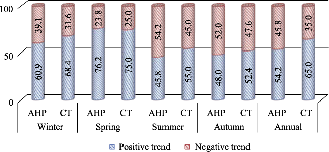
Groundwater resources have always been some of the most valuable resources of human settlements. Climate changes and ever-increasing water demands registered in the last century have led to diminishing levels of groundwater reserves, as well as reduced recharging potential. Therefore, in order to use groundwater aquifers in a sustainable manner, it is required to identify areas with higher replenishing potential. The current study addresses the issue of generating a map for identifying differently ranked groundwater recharging potential values, in the aquifers of the Moldavian Plain region, Romania. For the purpose of conducting the analysis, maps were created through GIS based multi-criteria Analytic Hierarchy Process (AHP) and Catastrophe Theory (CT), with seven relevant, thematic, spatial layers: precipitation distribution, lithological strata, soil texture, declivity, drainage density, land use and the distribution of groundwater level tendencies. The results of the two methods of analysis are similar. Prediction differences are of maximum 3%, in the case of extreme classes (very bad and very good) and in the case of middle classes the deviation is not greater than 0.4%. Following the validation of the results generated by the two methods that were applied, it was observed that the predictions offered by CT are more accurate. This aspect can be based on the fact that the main factors that contribute to the prediction are different. This type of workflow emphasizes the necessity of implementing appropriate groundwater management plans for mitigating reservoir scarcity/depletion, and recommending sustainable solutions for future groundwater exploitation practices.

Cite this article

Ionut MINEA , Daniel BOICU , Oana-Elena CHELARIU , Marina IOSUB , Andrei ENEA . Assessment of recharge capacity potential of groundwater using comparative multi-criteria decision analysis approaches[J]. Journal of Geographical Sciences, 2022 , 32(4) : 735 -756 . DOI: 10.1007/s11442-022-1970-0

1 Introduction

Human communities have evolved and are continuously evolving in tight relation to the exploitable water sources. Some of the oldest settlements have appeared and developed in close proximity to surface water sources, but the evolution of society and technology has determined the ever-increasing demand for exploiting underground aquifers. These are a valuable, alternative resource for the development of both urban and rural areas, which require more water (Çelik, 2019). The process of exploiting groundwater represents a crucial component in managing and optimizing water consumption, especially in rural environments (Das and Pardeshi, 2018). In contrast to surface water sources, which have high potential recharging rates (mostly from snowmelt and rainfall), underground aquifer regeneration is significantly slower, and is considered to be a restrictive factor for the sustainable usage of groundwater reserves (Dȍll and Fielder, 2008; Das, 2019). Analysis of aquifer regeneration processes is a major, world-wide concern, mostly due to the high pressure exerted by human related aspects (increase in demographics, intensification of agricultural practices, industrial growth, expansion and concentration of living areas in urban conglomerations, pollution) (Vörösmarty et al., 2010). In addition to these pressure sources, there are increasing climate change derived modifications to piezometric levels (Treidel et al., 2011; Taylor et al., 2013; Famiglietti, 2014). This aspect was emphasized in most climatic evolution and impact scenarios, related to the reduction in access for groundwater sources (Hiscock et al., 2011; IPCC, 2014; Gorelick and Zheng, 2015). Following several climate simulations concerning rainfall evolution, a series of scenarios foresee a drop of 40% in total precipitation amount, during winter and spring, and a possible frequency increase in the warm season (Busuioc et al., 2012; Bandoc and Prăvălie, 2015). These changes will lead to reduction in groundwater availability for numerous, large communities (Bădăluță et al., 2019). In order to emphasize the importance of each relevant factor, Analytic Hierarchy Process (AHP) approaches are largely used, aiding in identifying effective regeneration capacity for aquifers, and the corresponding recommendations for sustainable management plans (Nag and Ghosh, 2013; Kaliraj et al., 2014; Mallick et al., 2019; Kumar et al., 2020). It is a well proven method widely adopted by the scientific community, considered highly efficient when used as a tool in complex decision making, starting from relevant, thematic, spatial layers (Machiwal et al., 2011), and has been successfully used in evaluating the recharging potential of aquifers in semiarid regions (Murthy, 2000; Min et al., 2019), as well as urban areas (Aneesh et al., 2015).
As far as Romania is concerned, for 2020, 72,4% of the resident population is connected to the centralized water supply system. The lowest degree of households connected to the central system is found in the north-eastern region, accounting for 52.1% of the entire population (data source: The Romanian National Institute of Statistics). Furthermore, critical situations generated by the droughts of 2000, 2007, 2011, 2012, 2015 (Sfîcă et al., 2017) have only deepened the water supply crisis from underground sources, for local population. Northeastern part of Romania is embedded in this exact situation. Geological conditions and changes undergone in the type of land use, over the last centuries, have determined that the entire region would be transformed from a heavily-forested area, into an intensely-cultivated, agricultural one (Stângă and Niacșu, 2016). Furthermore, the spatial expansion of villages and cities has played an important role in the scarcity of alternative water sources, frequently undergoing water supply issues for the corresponding population (Țurcănașu, 2006).
Considering the social and economic conditions, associated with a region located at the eastern periphery of the European Union, it is required to reevaluate the recharging conditions of the aquifers, mostly in the context of poor monitoring of groundwater in the area (Minea and Craciun, 2012; Minea et al., 2012; Minea and Croitoru 2017; Boicu et al., 2019). For this purpose, a comparative multi-criteria decision analysis was applied to indicate the aquifers’ recovery capacity, over a plain region, located in the north-eastern part of Romania, encompassing a series of specific, thematic layers: lithology, land use, soil texture, slope, precipitation, drainage density, to which another relevant layer was added, consisting in the evaluation of the tendency for variation of piezometric levels, by applying the Innovative Tendency Analysis method (ITA) proposed by Șen (2012). Comparative multi-criteria analysis was performed using AHP and CT, these two methods are widely used in international literature to predict the recharging capacity of aquifers. Analyses that used this comparative method were performed by Jenifer and Jha (2017), Singh et al. (2018), Kaur et al. (2020), etc. The application of the two methods is scientifically validated by a series of articles for arid environment (Al-Abadi and Shahid, 2015; Al-Abadi et al., 2016; Boufekane et al., 2020). The novelty of this article is given by the fact that it transposes this methodology on a study area located in the temperate zone, with continental influences from the European area. The results obtained from this comparative analysis indicate that the CT method provides more accurate results that AHP for predicting the recharging capacity of groundwater. The prediction differences do not exceed values of 3% (in the case of extreme classes), and are reduced to 0.4% for the middle classes. The reasons that lead to these differences are given by the importance of some factors, in prediction process.

2 Materials and methods

2.1 Study area

The Moldavian Plain is located in the north-eastern region of Romania, and extends over a surface of approximately 8000 km2, with heights varying between 30 and 250 m (Figure 1). The location itself implies the existence of a temperate-continental type of climate, which is associated with a series of climate characteristics, such as multiannual average temperatures ranging from 8℃ (in the North), to 9℃ (in the South), and multiannual precipitation values varying from 520 mm/yr (in the south-eastern area), up to 600 mm/yr (in the western side) (Sandu et al., 2008; Iosub et al., 2020).
Figure 1 Location of the study area

2.2 Data used in Analytic Hierarchy Process

The analyzed data for the AHP methodology was obtained based on datasets already existing at national or international scale. The initial digital elevation model (DEM) used was ASTER GDEM, at a spatial resolution of 30×30 m per pixel (https://lpdaac.usgs.gov/), and the declivity raster was derived, based on it. In order to generate the thematic layers comprising of the tendency of the groundwater level, datasets were analyzed from 71 hydrogeological drillings, containing monthly level recordings, spanning from 1983 to 2018, monitored by the Prut-Bârlad Water Administration Branch, managed by National Water Administration. Precipitation distribution for the current study was generated from the ROCADA (Romanian Climate Dataset) dataset, which has national coverage (Bîrsan and Dumitrescu, 2014; Dumitrescu and Bîrsan, 2015). The layers containing information about the pedological and geological details were created by digitizing maps at 1:200,000 scale both from The Institute of Pedological and Agrochemical Research, Bucharest (1990), and the Geological Institute, also at a 1:200,000 scale (Romanian Geological Institute). Land use layer was extracted from Copernicus database, from the Corine Land Cover set, by choosing the most recent year with available data, 2018 respectively (https://land.copernicus.eu/).

2.3 Analytic Hierarchy Process and Catastrophe Theory simulation

AHP (Analytic Hierarchy Process) is a multi-criteria analysis methodology, widely adopted in numerous fields of research. It was developed by Saaty in 1980, suffering subsequent reevaluations, allowing for use at broader scale. The evaluation algorithm for each aforementioned factor, as well as each particular stage of the AHP methodological workflow, is encompassed in Figure 2. For the purpose of the present study, the analytic hierarchy process involved the completion of five different stages.
Figure 2 Flowchart of the applied methodology
The first stage consisted in the preparation of spatial, thematic layers, included in the AHP analysis. During the second stage, derived from these layers, several weighted scores have been granted, with values ranging from 1 to 5, for each aforementioned layer (Table 1). This type of methodological approach, using scores from 1 (value for the minimum impact) to 5 (value for the maximum impact), was previously undergone successfully, and proven to be relevant and quantitatively correct, when applied on factors influencing catastrophic floods in Romania (Hapciuc et al., 2016; Romanescu et al., 2018), or for other kinds of natural phenomena which pose significant threat on inhabited areas, such as landslides (Papathoma-Köhle et al., 2007), or the effect of large scale, tsunami waves (Sambah and Miura, 2013).
Table 1 Weight assessment using Analytic Hierarchy Process
Drainage density (km/km2) Ground
water level tendency
Precipitation (mm/yr) Slope (degree) Soil texture Land use Lithology (hardness) Evaluation rate
11.5-0.99 1.1-5.5 519.4-537.8 >15 Inland water bodies, Inland marshes Discontinuous urban fabric, Industrial or commercial units, Road and rail networks and associated land, Airports, Mineral extraction sites, Green urban areas, Sport and leisure facilities Limestone with flint, sandy limestone, limestone, marl, limey sandstone, gypsum 1
0.98-0.78 0.4-1 537.9-548.3 15-11 Clayey loamy, Clayey loamy -loamy, Loamy, Non-irrigated arable land, Vineyards, Fruit trees and berry plantations, Pastures, Land principally occupied by agriculture, with significant areas of natural vegetation Compact marls with sand intersections 2
0.77-0.59 ‒0.1-0.3 548.4-560.4 10-6 Clayey sandy-clayey loamy, Clayey sandy-loamy, Clayey-clayey loamy Inland marshes, Water courses, Lakes loamy marls with sand intersections, sands, gravels, marls 3
0.58-0.13 ‒0.9 to ‒0.2 560.5-577.5 5-2 Clayey sandy-clayey, Clayey,
Varied texture
Mixed forests, Coniferous forests, Deciduous forests, Natural grasslands, Transitional woodland-shrub Gravels, sands, river deposits, gravel terraces, sands-diluvial proluvial deposits 4
- ‒2.3 to ‒1 577.6-603.1 <1 Sandy clayey -clayey sandy, Sandy clayey -
clayey loamy Sandy-sandy clayey, Clayey-sandy
- - 5
The third stage involved establishing a dual comparison matrix (in pairs) for the thematic layers, which were subjected to weighted scores during the second stage, in order to identify the impact of each factor in the water level restoration process (Table 2).
Table 2 The main criteria and their relative importance
Groundwater level tendency Land use Drainage density Lithology Slope Soil texture Precipitation
Groundwater level tendency 1 1/3 1/2 1/4 1/2 1/3 1/4
Land use 1 1/2 1/4 1/2 1/3 1/4
Drainage density 1 1/3 1/2 1/2 1/2
Lithology 1 1/2 1/3 1/3
Slope 1 1/2 1/3
Soil texture 1 1/3
Precipitation 1
The fourth stage of the analysis implied normalizing the values that were generated in the aforementioned matrix, created during the third stage of the methodology. Based on this normalization process, the value depicting the degree of importance associated to each factor in the analysis could be identified. Validating the results was done by applying the Random Consistency Index (Saaty, 1980), and by also calculating the Consistency Index (1) (Çelik, 2019; Forman and Gass, 2001).
C.I=((λmax-n))/((n-1))
The final stage consists of the final model validation, by calculating the consistency ratio, resulted by dividing the consistency index (C.I.) to the value of the random consistency index (R.C.I.). Subsequently, a value of 0.086 was obtained for the consistency ratio. Considering the fact that the value of the ratio is below the 0.1 threshold, it is safe to affirm that the result is favorable and valid, and the entire matrix can be considered validated (Mohammad, 2014; Hapciuc et al., 2016). The final result, expressed in cartographic form, represents the recharging potential of groundwater in the Moldavian Field, and calculation of the corresponding layer was conducted by performing a weighted addition of each factor (expressed through a raster-based GIS layer), with their previously calculated, corresponding weights, as seen in Equation 2.
GRP = (3.02*P) + (1.98*L) + (1.49*ST) + (1.40*S) + (0.93*DD) + (0.69*LU) + (0.48*GRLT)
where GRP-Groundwater potential recharge; P-Precipitation; L-Lithology; ST-Soil texture; S-Slope; DD-Drainage density; LU-Land use; GRLT-Groundwater level tendency
CT or the Catastrophe Theory represents a modelling method which allows the analysis of the changes that occur within a natural phenomenon with immediate or discontinuous effects in its development environment (Thom, 1975). The corresponding methodology was first proposed back in 1960, by the mathematician Rene Thom, and his idea was borrowed and used in various fields. The occurrence probability of the discontinuities for each catastrophe type is expressed based on several equations whose control parameters are the coefficients (a, b, c, d, e) and the system’s behavior is provided by the use of two variables, x and y. The applicability of this method in determining the recharge potential is given and highlighted by the fact that it provides a multi-criteria analysis using multiple thematic layers, with varying degrees of importance, much like the AHP method.
The first stage in deploying the method was focused on establishing the thematic layers and, consequently, defining their corresponding classes (Table 3).
Table 3 Weight assessment using Catastrophe method
No. Theme Feature class Index value (Xij) Stdv. index value (Yij) Feature class weight (fwi) Mean
(Mj)
Theme weight (twj)
1 Drainage density (km/km2) 11.5-0.99 6.2 0.00 0.00 0.74 7
0.98-0.78 0.9 0.91 0.97
0.77-0.59 0.7 0.94 0.99
0.58-0.13 0.4 1.00 1.00
2 Groundwater level
tendency
1.1-5.5 3.3 0.00 0.00 0.73 6
0.4-1 0.7 0.53 0.81
‒0.1-0.3 0.1 0.65 0.90
‒0.9 to ‒0.2 ‒0.55 0.78 0.95
‒2.3 to ‒1 ‒1.65 1.00 1.00
3 Precipitation (mm/yr) 519.4-537.8 528.6 0.00 0.00 0.67 5
537.8-548.3 543.1 0.23 0.62
548.4-560.4 554.4 0.42 0.80
560.5-577.5 569 0.65 0.92
577.6-603.1 590.3 1.00 1.00
4 Slope
(degrees)
>15 15 0.00 0.00 0.67 3
15-11 13 0.14 0.53
10-6 8 0.50 0.84
5-2 3.5 0.82 0.96
<1 1 1.00 1.00
5 Soil texture Inland water bodies, Inland marshes 0.1 0.00 0.00 0.68 4
Clayey loamy, Clayey loamy-loamy, Loamy, 0.3 0.25 0.63
Clayey sandy-clayey loamy, Clayey sandy-loamy, Clayey-clayey loamy 0.4 0.50 0.84
Clayey sandy-clayey, Clayey, Varied texture 0.6 0.75 0.94
Sandy clayey-clayey sandy, Sandy clayey-clayey loamy, Sandy-sandy clayey, Clayey-sandy 0.7 1.00 1.00
6 Land use Discontinuous urban fabric, Industrial or commercial units, Road and rail networks and associated land, Airports, Mineral extraction sites, Green urban areas, Sport and leisure facilities 0.1 0.00 0.00 0.65 1
Non-irrigated arable land, Vineyards, Fruit trees and berry plantations, Pastures, Land principally occupied by agriculture, with significant areas of natural vegetation 0.3 0.33 0.70
Inland marshes, Water courses, Lakes 0.4 0.67 0.90
Mixed forests, Coniferous forests, Deciduous forests, Natural grasslands, Transitional woodland-shrub 0.6 1.00 1.00
7 Lithology (hardness) Limestone with flint, sandy limestone, limestone, marl, limey sandstone, gypsum 0.1 0.00 0.00 0.65 2
Compact marls with sand intersections 0.3 0.33 0.70
Loamy marls with sand intersections, sands, gravels, marls 0.4 0.67 0.90
Gravels, sands, river deposits, gravel terraces, sands-diluvial-proluvial deposits 0.6 1.00 1.00
The second stage involved the use of standardization equations for eliminating any anomalous values or outliers (Yij) (Equation 3), according to Jenifer and Jha (2017). Selecting the optimal equations for the standardization process was carried-out on the following criteria: if the thematic layer emphasizes good recharge conditions through low values for any given class, then the efficiency type equation is used. If the same, good recharge conditions are shown for low class values, the cost type equations are selected. As for the layers (soil texture, lithology and land cover), their classification was performed with respect to the infiltration rate, and the determined values were then divided into the number of layers used in the study.
${{Y}_{ij}}=\left\{ \begin{align} & \frac{{{x}_{il}}\min ({{x}_{ij}})}{\max ({{x}_{ij}})-\min ({{x}_{ij}})}\left( \text{For}\ \text{cost}\ \text{type} \right) \\ & \frac{\max ({{x}_{ij}})-{{x}_{ij}}}{\max ({{x}_{ij}})-\min ({{x}_{ij}})}\left( \text{For}\ \text{efficiency}\ \text{type} \right) \\ \end{align} \right.$
where
j is the number of thematic layers used in the study;
i is the number of classes corresponding to each layer;
xij is the average for each class for each layer;
yij is the standardized value for each class;
min(xij) and max(xij) are the minimum and maximum values for the classes of a given thematic layer.
The standardization process was preceded by a third, normalization stage (fwi). Within this stage, the equations from Table 4 were used, in accordance with the number of classes for each layer. The use of complementary and non-complementary approaches in the standardization process is a common practice. With the complementary approach, the control variables within a system have a tendency of complementing and compensating themselves. As a consequence, the general tendency of such variables is to reach an average value, which can be defined as:
$x=\frac{x_{a}+x_{b}+x_{c}+x_{d}}{4}$
Table 4 Normalization equation for the catastrophe models
Model Control variables State variables Function
Cusp 2 1 xa = x1/2, xb = x1⇓/3
Swallowtail 3 1 xa = x1/2, xb = x1⇓/3, xc = x1⇓⇓/4
Butterfly 4 1 xa = x1/2, xb = x1⇓/3, xc = x1⇓⇓/4, xd = x1⇓⇓⇓/5
Wigwam 5 1 xa = x1/2, xb = x1⇓/3, xc = x1⇓⇓/4, xd = x1⇓⇓⇓/5, xe = x1⇓⇓⇓⇓/6
The non-complementary approach is governed by the fact that the control variables cannot complement themselves, and as such, the lowest value for each state variable is considered instead, x = min (xa, xb, xc, xd) (Zhang, 2009). The complementary approach was applied in this study, because the thematic layers used to define the groundwater recharge process have the propensity to complement themselves.
The final stage involved the structuring of the layers according to their weighted averages (Mj) and yielding a cartographical output, which depicts the groundwater recharge potential in the Moldavian Plain, based on Equation 3.

3 Results and discussion

In order to assess the importance of each factor in the process of groundwater recharging for aquifers, the results were firstly analyzed individually, and afterwards, cumulatively.

3.1 Drainage density (DD)

The drainage density of the river network is defined as the cumulated, total length of rivers, overlapping a 1 km2 area. The drainage density influences both the distribution of water drainage, and the capacity of groundwater reserves to replenish themselves (Abdalla, 2012). Therefore, the lower the values that the drainage density records, the more potential for recharging groundwater aquifers the corresponding area has; these two parameters are related through inverse proportionality (Saha et al., 2010; Vasanthavigar et al., 2011). The highest density values are recorded in the northern and north-western regions (between 1.13 and 1.47 km/km²), while the lowest ones are found in the eastern and south-eastern parts (between 0.46 and 0.13 km/km²) (Figure 3a). The highest values for drainage density of the river network correspond to a 1-point score, by contrast to the lowest values, which form the highest scoring class (with values of 4). Scores of 1 and 4 represent a total of 3.8% and 7.3%, respectively, of the total surface of the Moldavian Plain. Classes that were attributed to the second and third scoring classes, correspond to 33.2% and 55.7%, respectively, of the total land area.

3.2 Precipitation (P)

In order to correctly address the manner in which the precipitation values influence the spatial distribution of subterranean water levels, a series of scientific studies based on analytical methods were taken into consideration (Viswanathan, 1984), and also statistical models, using multiple regressions (Matsumoto, 1992). Furthermore, precipitation is considered to be one of the most important sources for both groundwater input, and spatial distribution of groundwater quantity (Wu et al., 1996), making it a mandatory factor to be included in the current study.
The datasets that were analyzed, related to rainfall, are multiannual (1961-2013), and have been extracted out of ROCADA dataset (Romanian Climate Dataset), which have nation-wide coverage. The most consistent multiannual average rainfall values are recorded in the higher area, respectively in the western part, registering approximately 600 mm/yr. From a percentage perspective, it has been calculated that in the first class (corresponding to the minimum recharging potential), there is a total of 17.4% of the study area, while inside the class associated with a weight of 4, depicting the maximum recharging potential for groundwater, there are only 2.5% of the entire surface. The largest areas of the Moldavian Plain, encompassing 72.1%, belong to the class with a weight score of 2 (540-560 mm/yr).

3.3 Slope

The slope raster for the current study was automatically generated from the ASTER GDEM model. Slopes greater than 5 degrees, which occupy 0.02% of the analyzed area, generate more powerful runoff, in case of water originating from rainfall or snowmelt, reducing the possibility of it, infiltrating into the underlying strata.
The majority of the Moldavian Plain overlaps declivity classes that range from 1 to 5 degrees (64%), and also under 1% (18%), which favor decreased runoff speeds, especially on the longer slopes, and also the accumulation of water in microdepressions on ground surface, or along the general direction of river floodplains (Figure 3d). In these areas, there is a higher probability of water infiltrating the underlying strata, aiding in recharging of groundwater reserves (Chakrabortty et al., 2018).

3.4 Soil texture (ST)

Weight scores for the impact of the soil layer were given according to the hydrological soil classes recommended by the SCN-CN methodology (Iosub et al., 2020). In conjunction with this methodological approach, four soil classes were identified, each with its own weighted score. The highest value (4) was awarded for soil types with sandy, loamy and derived variants, in opposition to the soil classes which are characterized by a loamy-clayey texture, which received a weighted score of 1. Areas covered with large water extents (rivers, lakes and wetlands) have been given a score of 1 (Bagyaraj et al., 2013), due to the fact that the rock layers that lead to their formation are impermeable, with low chances of letting water infiltrate in the deeper, underlying strata (Figure 4a). According to the classification of the hydrological soil types, made by Chendeș (2011), based on the infiltration capacity of the water throughout the rock layers, where a score of 1 represents group D, a score of 2 corresponds to group C, a score of 3 is associated with group B, and 1 is awarded to group A. Out of all the different types of soil in the Moldavian Plain, the majority is given by soil group D, with an estimated 43.2%, while the pedological strata with high permeability, correlated with group A, only add up to 6%.

3.5 Lithology

The lithological characteristics of a given area play a fundamental role in the distribution of groundwater aquifers. The Moldavian Plain has evolved on a platform domain, where sedimentary deposits have settled and cemented together during a succession of geological periods (Ionesi et al., 2005). Towards the surface, Sarmatian deposits prevail, in a succession of marl and compact clay strata, with sandy intercalations, while along the hydrological network, there are alluvial deposits (terraces and floodplains), where sands and Quaternary gravel are deposited, with thicknesses varying from 0.5 to 1.5 m (Minea, 2012). In the northern part of the region, there are isolated locations where marly limestone and sand stone-intercalated limestone surface encapsulate reduced volumes of groundwater (Figure 4b). The impact scores were attributed based on the rocks’ capacity to allow water to infiltrate into underlying strata (permeability).
Figure 3 Selected factors for Analytic Hierarchy Process analysis (a. drainage density; b. groundwater level tendency; c. precipitation; d. slope)
A score of 1 reflects the types of rocks that obstruct water from infiltrating. Rocks associated with high infiltration values were awarded a score of 4, corresponding mainly with areas of sand deposits. Based on the spatial distribution, the largest surfaces are formed on clayey marlstone, with sand intercalations, with a cumulated area of 79.2%.
Figure 4 Selected factors for Analytic Hierarchy Process analysis (a. soil texture; b. Lithology)

3.6 Land use (LU)

The land use spatial distribution layer was derived from the Corine Land Cover dataset, for 2018 (Figure 5). This layer was taken into consideration not only because it reflects the current land use of a given area, but also the effect each class plays on the water recharge capacity into the ground (Yashon and Ryutaro, 2014). Alongside physical processes, and their association with different climate, geologic, topographic, pedological, vegetation conditions, and water presence, it can be noted that this particular spatial layer has a tremendous role in emphasizing the locations where water can be stored underground (Pareta and Pareta, 2011). Depending on how the land use is distributed, areas with intensive agricultural activity have been granted a score of 4, while the built-up areas, along which water infiltration is almost completely inhibited, were attributed a score of 1. For reference, the built-up areas cumulate a total of 10.3%, while the areas with high values of water infiltration into the underlying strata occupy a total of 79.8% (Table 1).
Figure 5 Selected factors for Analytic Hierarchy Process analysis: land use

3.7 Groundwater level tendency

The groundwater level tendency (GRLT) represents the positive or negative value of the groundwater level. Although the methodology suggested by Sen (2012) has its applications for extreme values of flowrate, precipitation and temperature, for the purpose of the current study, it was adapted to and applied for the variation of groundwater levels, considering that its excessive exploitation can induce significant harmful effects, from an economic, ecologic and environmental point of view (Celik, 2019). The proper methodological workflow involves dividing the dataset associated with the piezometric water level into two equal halves, arranged ascendingly. Depending on the particular place on which point values appear that are in relation to a 1:1 line, the exact type of variation is established, of growth of decrease (Wang et al., 2020).
For estimating the trend, an Innovative Trend Analysis (ITA) slope is required to be calculated. The equation itself is based on an equation first proposed by (Sen, 2017), which was adapted to and applied for calculating and detecting extreme variations (5).
s=$\frac{2(\bar{y_{2}}-\bar{y_{1}})}{n}$
where s denotes slope; $\bar{y_{2}}$, the average of the first data series; $ \bar{y_{1}}$ the average of the second data series; n denotes the number of recordings
The slope value resulting from Equation 6, is related to a confidence limit (CL). In the situation that the value of slope is greater than the value of the confidence limit, a trend is considered to exist in the analysis.
CL(1-α)=0±scritσs
where α is the percent of significance level; scrit is standard deviation values; σs is the slope of standard deviation.
Data referring to the tendency of the groundwater level were spatialized in GIS software, by means of Kriging-based interpolation (Sun et al, 2009).
The spatial distribution of the groundwater level tendency in the old avian Field reveals that approximately 43% of its entire area is associated with a positive tendency, while, by contrast, the remaining 57% fit in the negative tendency values (Figure 3b). The final class with values ranging between 1.1 and 5.5 represents a total of 21.7% of the analyzed surface. Taking into consideration its association with the most negative impact it poses upon the land areas it overlaps on, it was integrated in the 5th class (Table 1).

3.8 Groudwater potential index maps

Analyzing the pair comparison matrix of all factors revealed that the atmospheric precipitations and the lithology play the most important roles, cumulating a weight score of approximately 50%, result also confirms in the independent study of Çelik (2019), for precipitation, and Mallick et al. (2019), for lithology, precipitations being also considered the main factor in the recharging process. To these dominant factors, less decisive contributions come from the soil texture (which contributes by 15%), slope value (with a score of 14%), the drainage density for the river network (9%), land use-which accounts for 7%, and finally, 5% for the tendency of the groundwater level. The impact of climate change, which is ever more pregnant in this region (Minea and Croitoru, 2015; 2017), to which human influence is added into equation (determined by the increase in population density in numerous areas), is well emphasized in the southern part of the study area. The southern area, characterized by increased problems concerning groundwater recharging, cumulates a total number of 700,000 inhabitants (Hârlău, Târgu Frumos, Podu Iloaiei, Iași), while the opposite, northern region, with issues associated to remote areas, add up to a total of 400,000 inhabitants, for 2011 (Flămânzi, Botoșani, Bucecea, Săveni, Dorohoi, Darabani) (http://www.insse.ro/cms/). This problematic aspect is also emphasized by analyzing the groundwater level tendency, with negative values in proportions of approximately 57% of the entire area, overlapping mostly over the regions with high growth in built-up spaces, and also high population densities, as well as low values of precipitation, in strict correlation to the lower heights.
Results of the study upon the recharging potential of groundwater reserves are underlined in Figures 6 and 7, depicting five classes for the groundwater potential recharge (Huang et al., 2018). By analyzing the data obtained after classification, it has been observed that 45% of the study area is characterized by very low and low recharge potential for the groundwater reserves, with a total of approximately 3600 km2.
Figure 6 Groundwater potential index map obtained using Analytic Hierarchy Process
The overlapping of the average multiannual precipitation values reaching 600 mm/yr in the western side, on top of the sandy substrate generate the highest type of recharge potential, corresponding to 5% of the surface, or approximately 380 km2.
Applying the Innovative Trend Analysis (ITA) methodology in order to obtain a thematic layer integrated into the analysis of the recharging potential for groundwater, resulted in highlighting the regions where the groundwater reserves are subjected to anthropic stress.
Although the weight of the thematic layer corresponding to the groundwater level tendency had a value of just 5% (Equation 2) inside the analysis matrix (implicitly placed on the last spot, as importance), it has been observed that the application of innovative trend analysis (ITA) interpolation strongly correlates with the final result-groundwater potential recharge (GPR), revealing the fact that the greatest problems in groundwater level are located in the southern part of the Moldavian Plain. As a consequence, the implementation of the ITA methodology for the generation of the GRP map can represent a potential, future instrument that will aid in establishing rationally throughout the management plans for groundwater resources, acknowledging its accuracy in association with the areas that are associated with these usage issues.
Figure 7 Groundwater potential index map obtained using Catastrophe Theory

3.9 Validation of AHP and CT using map generated from ground/field data

Validating the results and isolating the optimal method was done using the data obtained based on the innovative trend method, which was applied in a study that was undertaken on the same research area, that had at its core, the analysis of the trends for 71 hydrogeological drillings (Minea et al., 2020). Since the data is sourced directly from the field, the precision validation for the two analysis methods for the groundwater potential within drillings can be seen as a shift towards a quantitative approach.
The validation process was focused on overlaying the drillings layer onto the yielded cartographical products and extracting the drill locations, which fell within the established classes. For each class delineation based on the groundwater recharge criteria (very bad, bad, medium, good and very good), this pattern was performed: in a class which shows a very bad and bad recharge, the negative trend from the drillings must emphasize a high percentage for an optimal validation. For a class which shows medium recharge potential, the drillings must highlight a trend that has a pronounced positive shift for achieving good validation values. For the classes with good and very good recharge potential, the optimal validation can be achieved if the drillings show an almost net percentage shift towards the positive spectrum for the trend. The method with the best validation is CT, as it manages to offer the best emphasis when relating the underground conditions to the resulting data. For the areas which show very bad and bad recharge capacity, it was found that approximately 60% of the drillings which fall within this class carry an inherent negative trend, for the CT method, and 40% for the AHP method (Figure 8). For the median class (medium recharge capacity), the positive trend was represented with a 50% percentage for both methods, but the CT method does highlight the results more (Figure 9). For the good and very good recharge capacity classes, the CT method is also well represented, with 73% for the positive trend drills, as opposed to only 61% for the same drills but with the AHP method (Figure 10). One reason behind the effectiveness of the CT method could be the fact that it focuses on the drainage network more, and it accounts it as a prime factor, and not on precipitations, which is the main factor considered in the AHP method. However, one must also highlight the fact that the drillings used in the study are located mostly in the floodplains of the rivers and not on the slopes or ridges.
Figure 8 Validation for low and very low classes
Figure 9 Validation for medium classes
Figure 10 Validation for high and very high classes
Besides the annual analysis, this validation method can also be used for emphasizing the seasonal stages, which are characteristic to the climate specific to the study area. The negative trends which occur during autumn, presented in Figure 8, are characterized by the fact that the soil saturation, which is reached mainly through precipitation, occurs at a diminished rate, because the drought periods prevent the aquifer from initializing or even completing its regeneration. The positive trends however, are a consequence of the seasonal overlap of the snowmelt and spring precipitations, which result in a better overall groundwater recharge.

3.10 Comparative analysis of Analytic Hierarchy Process and Catastrophe Theory

When looking at the extension area for both the AHP and CT, the two methods manage to highlight comparatively similar surfaces for the given classes. The most notable differences occur within the very bad and very good classes. For the very bad class, the AHP method provides an overestimation of the references surface by 12%, as opposed to CT, which stands at 9.8%. For the very good class, the CT method overestimates the surface with 12% values and the AHP method with 10% values (Figure 11). For the average and good classes, the AHP method yields slightly larger values than CT, with 31.7% and 22.3%, respectively and 31.4% and 21.7%, respectively. The values for the two methods for the bad class are separated by only a 0.4% difference, with 24.2% for CT and 23.8% for AHP.
Figure 11 Groundwater potential zones
Table 5 Groundwater potential zones AHP
Potential classes Potential value Potential index Area (km2) Area (%)
Very low 17.4-25.2 1 963 12
Low 25.2-28.3 2 1906.7 23.8
Medium 28.3-31.4 3 2544.1 31.7
High 31.4-35.6 4 1790.7 22.3
Very high 35.6-54.1 5 807.3 10
CT
Potential classes Potential value Potential index Area (km2) Area (%)
Very low 8.8-11.9 1 784.3 9.8
Low 11.9-13.3 2 1942.5 24.2
Medium 13.3-14.6 3 2516.3 31.4
High 14.6-16.1 4 1739.8 21.7
Very high 16.1-24.8 5 1027.9 12.8

5 Conclusions

For the purpose of determining the recharging potential of groundwater for the north-eastern region of Romania, seven thematic layers were analyzed: precipitation distribution, lithological conditions, soil texture, slope, river drainage density, land use classes and the tendency of the groundwater water level. The layers were pre-processed and prepared using GIS techniques, and the importance weight of each parameter was generated by applying the AHP (Analytic Hierarchy Process) and CT (Catastrophe Theory) methodologies. First of all, following the application of the two methods, it was found that the results obtained are similar with small differences in the prediction of extreme values. After validating the results, by associating them with the water level in the hydrological boreholes, it was concluded that the CT method generates a better prediction rate than AHP, for the study area. Also, the prediction can vary in accuracy, when analyzed by seasons. Second of all, the analysis of the maps indicates the fact that the recharge potential reveals low values for 35% of the surface, which emphasizes the requirement of implementing novel, more sustainable administrative measures. This is required, in order to mitigate the degradation and overexploitation of groundwater for better resource management in the future. Thirdly, the average values account for approximately 31% of the entire study area. In these areas, problems that arise with the recharging potential of groundwater are not major, but require the implementation of a rational use plan for the summer seasons, which are commonly associated with hydrological droughts. This potential class is found mostly in the areas where the soil texture dominantly corresponds to loam and clay, and rocks associated with reduced permeability values, therefore inducing low infiltration potential for surface water sources, such as rainfall or snowmelt. Fourthly, the areas with the highest potential benefit from significant contributions of water into the underlying strata, favoring normal requirements for various sectors, such as household consumption, agriculture, or industrial activities, on a year-long basis. These areas cumulate 22% of the total area of the Moldavian Plain. The study reveals that the class with the highest generated recharge potential is mostly concentrated in the western region, overlapping a sandy lithological stratum, specific to river floodplains, to which precipitation values aid significantly with a multiannual average value of 600 mm/yr. Lastly, by applying a methodological approach based on a comparison between AHP and CT workflows, the spatial results were cross-validated, therefore confirming the findings of the areas studied. The results reveal the distribution of the groundwater recharge potential throughout the Moldavian Plain.

Acknowledgments

This work was supported by a grant of the Romanian Ministry of Education and Research CNCS-UEFISCDI, project number PN-III-P1-1.1-TE-2019-0286, within PNCDI III, the Department of Geography, Faculty of Geography and Geology, from “Alexandru Ioan Cuza” University of Iasi, and the infrastructure was provided through the POSCCE-O 2.2.1, SMIS-CSNR 13984-901, No.257/28.09.2010 Project, CERNESIM.
[1]
Abdalla F, 2012. Mapping of groundwater prospective zones using remote sensing and GIS techniques: A case study from the Central Eastern Desert, Egypt. Journal of African Earth Sciences, 70: 8-17.

DOI

[2]
Al-Abadi A M, Shahid S, 2015. A comparison between index of entropy and catastrophe theory methods for mapping groundwater potential in an arid region. Environmental Monitoring and Assessment, 187(9) 576: 1-21.

DOI

[3]
Al-Abadi A M, Al-Temmeme A A, Al-Ghanimy M A, 2016. A GIS-based combining of frequency ratio and index of entropy approaches for mapping groundwater availability zones at Badra-Al Al-Gharbi-Teeb areas, Iraq. Sustainable Water Resources Management, 2(3): 265-283.

DOI

[4]
Aneesh R, Paresh Chandra D, 2015. Groundwater potential recharge zonation of Bengaluru Urban District: A GIS based Analytic Hierarchy Process (AHP) technique approach. International Advanced Research Journal in Science, Engineering and Technology, 2(6): 129-136.

[5]
Bagyaraj M, Ramkumar T, Venkatramanan S et al., 2013. Application of remote sensing and GIS analysis for identifying groundwater potential zone in parts of Kodaikanal Taluk, South India. Frontiers of Earth Science, 7(1): 65-75.

DOI

[6]
Bandoc G, Prăvălie R, 2015. Climatic water balance dynamics over the last five decades in Romania’s most arid region, Dobrogea. Journal of Geographical Sciences, 25(11): 1307-1327.

DOI

[7]
Bădăluță C A, Perțoiu A, Ionita M et al., 2019. Stable H and O isotope-based investigation of moisture sources and their role in river and groundwater recharge in the NE Carpathian Mountains, East-Central Europe. Isotopes in Environmental and Health Studies, 55(2): 161-178.

DOI

[8]
Bîrsan M V, Dumitrescu A, 2014. ROCADA: Romanian daily gridded climatic dataset (1961-2013)V1.0. Bucharest, Romania: National Meteorological Administration.

[9]
Boicu D, Minea I, Chelariu O E, Iosub M, 2019. Evaluation on groundwater recharges capacity using AHP method-Case study: The Moldavian Plain. Air and Water-Components of the Environment, 181-188.

[10]
Boufekane A, Meddi H, Meddi M, 2020. Delineation of groundwater recharge zones in the Mitidja plain, north Algeria, using multi-criteria analysis, Journal of Hydroinformatics, 22(6): 1468-1484.

DOI

[11]
Busuioc A, Caian M, Bojariu R et al., 2012. Climate change scenarios in Romania for 2001-2030. Bucharest, Romania: National Meteorological Administration.

[12]
Çelik R, 2019. Evaluation of groundwater potential by GIS-based multicriteria decision making as a spatial prediction tool: Case study in the Tigris River Batman-Hasankeyf Sub-Basin, Turkey. Water, 11(12): 2630.

DOI

[13]
Chakrabortty R, Pal S C, Malik S et al., 2018. Modeling and mapping of groundwater potentiality zones using AHP and GIS technique: A case study of Raniganj Block, Paschim Bardhaman, West Bengal. Modeling Earth Systems and Environment, 4(3): 1085-1110.

DOI

[14]
Chendeş V, 2011. Resursele de apă din Subcarpaţii de la Curbură. Evaluări geospaţiale. Bucharest, Romania: Romanian Academy Publishing. (in Romanian)

[15]
Copernicus Land Monitoring Service, 2020. Available online: https://land.copernicus.eu/

[16]
Das S, Pardeshi S D, 2018. Morphometric analysis of Vaitarna and Ulhas river basins, Maharashtra, India: Using geospatial techniques. Applied Water Science, 8: 158.

DOI

[17]
Das S, 2019. Comparison among influencing factor, frequency ratio, and analytical hierarchy process techniques for groundwater potential zonation in Vaitarna basin, Maharashtra, India. Groundwater for Sustainable Development, 8: 617-629.

DOI

[18]
Dȍll P, Fielder K, 2008. Global-scale modeling of groundwater recharge. Hydrology and Earth System Sciences, 12: 863-885.

DOI

[19]
Dumitrescu A, Bîrsan M V, 2015. ROCADA: A gridded daily climatic dataset over Romania (1961-2013) for nine meteorological variables. Natural Hazards, 78(2): 1045-1063.

DOI

[20]
Famiglietti J S, 2014. The global groundwater crisis. Nature Climate Change, 4: 945-948.

DOI

[21]
Forman E, Gass S, 2001. The analytic hierarchy process: An exposition. Operations Research, 49(4): 469-486.

DOI

[22]
Gorelick S M, Zheng C, 2015. Global change and the groundwater management challenge. Water Resources Research, 51: 3031-3051.

DOI

[23]
Hapciuc O E, Iosub M, Tomasciuc A I et al., 2016. Identification of the potential risk areas regarding the floods occurrence within small mountain catchments. Geobalcanica, 177-183.

[24]
Hiscock K, Sparkes R, Hodgson A, 2011. Evaluation of future climate changes impacts on European groundwater resources. In: Treidel H, Martin-Bordes J J, Gurdak J J (IAH International Contributions to Hydrogeology, eds.). Climate Change Effects on Groundwater Resources: A Global Synthesis of Findings and Recommendations. 351-366.

[25]
Huang Y, Zuo R, Li J et al., 2018. The spatial and temporal variability of groundwater vulnerability and health risk in the Limin District, Harbin, China. Water, 10(6): 686.

DOI

[26]
Institutul de Cercetări pentru Pedologie și Agrochimie, 1990. Harta solurilor României, scara 1: 200000. Bucharest, Romania.

[27]
Institutul Geologic Român, 1968. Harta geologică a României, scara 1:200000. Bucharest, Romania.

[28]
Institutul National de Statistica. Available online: http://www.insse.ro/cms/

[29]
Ionesi L, Ionesi B, Roșca V et al., 2005. The Middle and Upper Sarmatian on the Moldavian Platform. Bucharest, Romania Romanian: Academy Press. (in Romanian)

[30]
Iosub M, Minea I, Chelariu O E, Ursu A, 2020 Assessment of flash flood susceptibility potential in Moldavian Plain (Romania). Journal of Flood Risk Management, 13(4): 1-12.

[31]
IPCC, 2014. Climate Change 2014: Synthesis Report. Contribution of Working Groups I, II and III to the Fifth Assessment Report of the Intergovernmental Panel on Climate Change [Core Writing Team, R.K. Pachauri and L.A. Meyer (eds.)]. IPCC, Geneva, Switzerland, 151pp.

[32]
Jenifer A M, Jha M K, 2017. Comparison of analytic hierarchy process, catastrophe and entropy techniques for evaluating groundwater prospect of hard-rock aquifer systems, Journal of Hydrology, 548: 605-624.

DOI

[33]
Kaliraj S, Chandrasekar N, Magesh N S, 2014. Identification of potential groundwater recharge zones in Vaigai Upper Basin, Tamil Nadu, using GIS-based analytical hierarchical process (AHP) technique. Arabian Journal of Geosciences, 7(4): 1385-1401.

DOI

[34]
Kaur L, Rishi M S, Singh G et al., 2020. Groundwater potential assessment of an alluvial aquifer in Yamuna sub-basin (Panipat region) using remote sensing and GIS techniques in conjunction with analytical hierarchy process (AHP) and catastrophe theory (CT). Ecological Indicators, 110: 105850.

DOI

[35]
Kumar V, Mondal N C, Ahmed S, 2020. Identification of groundwater potential zones using RS, GIS and AHP techniques: A case study in a part of Deccan volcanic province (DVP), Maharashtra, India. Journal of the Indian Society of Remote Sensing, 48: 497-511.

DOI

[36]
Machiwal D, Jha M K, Mal B C, 2011. Assessment of groundwater potential in a semi-arid region of India using remote sensing, GIS and MCDM techniques. Water Resources Management, 25: 1359-1386.

DOI

[37]
Mallick J, Abad Khan R, Ahmed M et al., 2019. Modeling groundwater potential zone in a semi-arid region of Aseer using fuzzy-AHP and geoinformation techniques. Water, 11: 2-29.

DOI

[38]
Matsumoto N, 1992. Regression analysis for anomalous changes of ground water level due to earthquakes. Geophysical Research Letters, 19(12): 1193-1196.

DOI

[39]
Min L, Qi Y, Shen Y et al., 2019. Groundwater recharge under irrigated agro-ecosystems in the North China Plain: From a critical zone perspective. Journal of Geographical Sciences, 29(6): 877-890.

DOI

[40]
Minea I, 2012. Bahlui Drainage Basin:Hydrological Study. Iași, Romania: Alexandru Ioan Cuza University Press, pp366. (in Romanian)

[41]
Minea I, Boicu D, Chelariu O E, 2020. Detection of groundwater levels trends using innovative trend analysis method in temperate climatic conditions. Water, 12(8): 2129.

DOI

[42]
Minea I, Butelcă D, Niacşu L, 2012. Models of variation of the groundwater level in drought conditions: Case study of the Barlad upper basin. Geographia Napocensis, 4(1): 75-82. (in Romanian)

[43]
Minea I, Crăciun I, 2012. Simulation models to evaluate the groundwater resources in Bahlu river basin, Romania. Journal of Environmental Protection and Ecology, 13(3): 1600-1607.

[44]
Minea I, Croitoru A E, 2015. Climate Changes and their impact on the variation of groundwater level in the Moldavian Plateau (Eastern Romania). 15th International Multidisciplinary Scientific Geoconference (SGEM), 1: 137-145.

[45]
Minea I, Croitoru A E, 2017. Groundwater response to changes in precipitations in North-Eastern Romania. Environmental Engineering and Management Journal, 16(3): 643-651.

DOI

[46]
Mohammad R, 2014. Landslide susceptibility zonation using analytical hierarchy process and GIS for the Bojnurd region, northeast of Iran. Landslides, 11(6): 1079-1091.

DOI

[47]
Murthy K S R, 2000. Ground water potential in a semi-arid region of Andhra Pradesh: A geographical information system approach. International Journal of Remote Sensing, 21(9): 1867-1884.

DOI

[48]
Nag S K, Ghosh P, 2013. Delineation of groundwater potential zone in Chhana Block, Bankura District, West Bengal, India using remote sensing and GIS techniques. Environmental Earth Sciences, 70(5): 2115-2127.

DOI

[49]
Papathoma-Köhle M, Neuhäuser B, Ratzinger K et al., 2007. Elements at risk as a framework for assessing the vulnerability of communities to landslides. Natural Hazards and Earth System Sciences, 7: 765-779.

[50]
Pareta K, Pareta U, 2011. Quantitative morphometric analysis of a watershed of Yamuna basin, India using ASTER (DEM) data and GIS. International Journal of Geomatics and Geosciences, 2(1): 248-269.

[51]
Romanescu G, Hapciuc O E, Minea I et al., 2018. Flood vulnerability assessment in the mountain-plateau transition zone: Case study for Marginea village (Romania). Journal of Flood Risk Management, 11: 502-513.

DOI

[52]
Saaty T L, 1980. The Analytic Hierarcy Process. New York, NY, USA: McGraw-Hill.

[53]
Saha D, Dhar Y R, Vittal S S, 2010. Delineation of groundwater development potential zones in parts of marginal Ganga alluvial plain in south Bihar, eastern India. Environmental Monitoring and Assessment, 165(1-4): 179-191.

DOI

[54]
Sambah A, Miura F, 2013. Remote sensing, GIS, and AHP for assessing physical vulnerability to tsunami hazard. International Journal of Environmental, Chemical, Ecological Geological and Geophysisical Engineering, 7(10): 671-679.

[55]
Sandu I, Pescaru V I, Poiana I et al., 2008. Climate of Romania. Bucharest, Romania: Romanian Academy Press, 365. (in Romanian)

[56]
Sfîcă L, Croitoru A E, Iordache I et al., 2017. Synoptic conditions generating heat waves and warm spells in Romania. Athmosfere, 8(3): 50.

[57]
Singh L K, Jha M K, Chowdary V M, 2018. Assessing the accuracy of GIS-based Multi-Criteria Decision Analysis approaches for mapping groundwater potential. Ecological Indicators, 91: 24-37.

DOI

[58]
Stângă I C, Niacșu L, 2016. Using old maps and soil properties to reconstruct the forest spatial pattern in the late 18th century. Environmental Engineering and Management Journal, 15(6): 1369-1378.

DOI

[59]
Sun Y, Kang S, Li F et al., 2009. Comparison of interpolation methods for depth to groundwater and its temporal and spatial variations in the Minqin oasis of northwest China. Environmental Modelling & Software, 24(10): 1163-1170.

[60]
Șen Z, 2012. Innovative trend analysis methodology. Journal of Hydrologic Engineering, 17(9): 1042-1046.

DOI

[61]
Șen Z, 2017. Innovative trend significance test and applications. Theoretical and Applied Climatology, 127: 939-947.

DOI

[62]
Taylor R, Scanlon B, Döll P et al., 2013. Ground water and climate change. Nature Climate Change, 3(4): 322-329.

DOI

[63]
Thom R, 1975. Structural Stability and Morphogenes. Reading, Mass.: W. A. Benjamin: Taylor and Francis.

[64]
Treidel H, Martin-Bordes J L, Gurdak J J, 2011. Climate Change Effects on Groundwater Resources. A Global Synthesis of Findings and Recommendations. London, UK:CRC Press, Taylor & Francis Group, pp. 351-365.

[65]
Ţurcănaşu G, 2006. The evolution and current state of the settlement system in Moldova. Iaşi, Romania: Demiurg, pp. 397. (in Romanian)

[66]
U.S. Geological Survey-Earth Data. Available online: https://lpdaac.usgs.gov/,

[67]
Vasanthavigar M, Srinivasamoorthy K, Vijayaragavan K et al., 2011. Groundwater potential zoning in Thirumani-muttar sub-basin Tamilnadu, India: A GIS and remote sensing approach. Geo-spatial Information Science, 14(1): 17-26.

DOI

[68]
Viswanathan M N, 1984. Recharge characteristics of an unconfined aquifer from the rainfall-water table relationship. Journal of Hydrology, 70(1-4): 233-250.

DOI

[69]
Vörösmarty C, McIntyre P, Gessner M et al., 2010. Global threats to human water security and river biodiversity. Nature, 467: 555-561.

DOI

[70]
Wang Y, Xu Y, Tabari H et al., 2020. Innovative trend analysis of annual and seasonal rainfall in the Yangtze River Delta, eastern China. Atmospheric Research, 231: 104673.

DOI

[71]
Wu J, Zhang R, Yang J, 1996. Analysis of rainfall-recharge relationships. Journal of Hydrology, 177(1/2): 143-160.

DOI

[72]
Yashon O, Ryutaro T, 2014. Urban flood vulnerability and risk mapping using integrated multi-parametric AHP and GIS: Methodological overview and case study assessment. Water, 6(6): 1515-1545.

DOI

[73]
Zhang T, 2009. Application of the catastrophe progression method in predicting coal and gas outburst. Mining Science and Technology (China), 19(4): 430-434.

DOI

Outlines

/