Original article

The recent evolution of dune landforms and its environmental indications in the mid-latitude desert area (Hexi Corridor)

  • ZHU Bingqi
Expand
  • Key Laboratory of Water Cycle and Related Land Surface Processes, Institute of Geographic Sciences and Natural Resources Research, CAS, Beijing 100101, China

Zhu Bingqi, PhD and Professor, specialized in Quaternary geomorphology and Quaternary environmental changes.

Received date: 2021-12-03

  Accepted date: 2022-01-22

  Online published: 2022-06-25

Supported by

National Natural Science Foundation of China(No.41930640)

National Natural Science Foundation of China(No.41771014)

The Second Tibetan Plateau Scientific Expedition and Research(No.2019QZKK1003)

Abstract

The history of dune landform changes and dust activity at mid-latitudes is a good archive for exploring environmental changes and related landscape response. In this study, the dynamic changes, material sources, dust activity history and the influencing factors of typical sand dunes in the Hexi Corridor were comprehensively analyzed from the aspects of aeolian geomorphology, grain-size sedimentology, geochemistry and climatology. The results show that in the past half century, the typical crescent-shaped dunes and chains of crescent-shaped dunes in the study area have moved or swayed greatly, with an average speed ranging from 0.8 m/a (Dunhuang) to 6.2 m/a (Minqin). The dynamic changes of sand dunes are mainly affected by annual precipitation, annual average wind speed and annual gale days, which indicates that climate is the primary influencing factor of dune landform changes. The three-stage grain-size curve model of dune sands is obviously different from that of gobi sediments (two-stage), revealing the “immaturity” of the latter in sedimentology, while the former has experienced efficiently aeolian differentiation and non-local origin. The comprehensive evidences of paleogeography, sedimentology and geochemistry reveal that the source materials of sand dunes are mainly alluvial/proluvial and palaeo-fluvial sediments, including clastic sediments in the denudation/erosion zones of the north and south piedmonts. Indicators such as the proportion of surface fine particles, the coverage of surface salt crusts, and the content of erodible sandy materials indicate that the western gobi areas are not the main source areas of wind-blown dust in the central and eastern parts of the Hexi Corridor. The spatial distribution of the movement direction of sand dunes is similar to that of the regional dominant wind direction, which indicates that the difference in the dynamic evolution of dune landforms between the east and west of the Hexi Corridor should be controlled by the regional-scale wind system, that is, controlled by the dynamic mechanism rather than the difference in material sources. The warming and humidification of the Hexi climate is a synchronous response to the global warming and the strengthening of the Asian Summer Monsoon. It is also the main reason for the reduction of dust storms in the study area, which means that a potential inverse desertification process exists in the Hexi Corridor during the same period and it is also controlled by climate change. However, the process of desertification in the oasis areas during the period is caused by groundwater fluctuation affected by human activities.

Cite this article

ZHU Bingqi . The recent evolution of dune landforms and its environmental indications in the mid-latitude desert area (Hexi Corridor)[J]. Journal of Geographical Sciences, 2022 , 32(4) : 617 -644 . DOI: 10.1007/s11442-022-1964-y

1 Introduction

Aeolian sand landform and its sedimentary strata have recorded the environmental changes in the upwind source areas or desert areas and their response to global climate changes and human activities. It is usually an important and even unique environmental archive for the evolution of dryland landscapes (Goudie, 2002; Lancaster et al., 2013, 2016; Williams, 2014; Yang et al., 2019). About 566,000 km2 of land area in China are covered by aeolian sands, covering a variety of geomorphological and tectonic backgrounds ranging from 155 m below sea level to 5000 m above sea level (Yang, 2006). Among them, the desert landscape dominated by active sand dunes is mainly distributed in arid and extremely arid areas with an annual average precipitation of less than 200 mm, while the sandy landscape dominated by semi-fixed dunes and vegetation dunes (fixed dunes) mainly appear in semi-arid areas with an annual average precipitation between 200 and 400 mm (Zhu et al., 1980). These desert landscapes are the products of the interaction between the internal forces and external forces of the earth system on the long-term and short-term scales. In turn, these deserts may directly affect the global climate and ecosystem through the wind-blowing dust cycles (Goudie, 2002; Yang, 2006). Therefore, the understanding of desert landscape evolution will increase our understanding of the earth system.
Regarding the formation and evolution of desert landscapes in inland China, a typical mid-latitude arid region in the Northern Hemisphere (NH), the paleoenvironmental records of depositional sequences of the loess and paleosol on the Loess Plateau from the periphery of the deserts show that the deserts in northwestern China may have existed as early as 22 Ma (Gou et al., 2002, 2004), but the geomorphological and sedimentological evidence found in the hinterland of the deserts shows that the modern-scale landscapes of these deserts may be formed much younger (Yang, 2006; Yang et al., 2004, 2006). In many desert areas in northwestern China, lacustrine and fluvial sediments from the Late Pleistocene or even Holocene are unconformably buried under sand dunes, indicating that the environment of these desert areas has undergone abrupt changes during the Late Quaternary (Yang, 2006; Chen et al., 2020). For example, in the Hexi Corridor in the mid-latitudes of China and the Badain Jaran Desert on its northern margin, although disputes still exist in people’s understanding of the formation mechanism of giant sand dunes (also called “Sand Mountains”), such as “climate control”, “tectonic/geomorphological control”, “groundwater control” and other hypotheses, the geomorphological investigation is still crucial to resolve these disputes. It is conceivable that any state of the dynamic formation process of sand dunes, i.e., the process of regional desertification, will be key to understanding this problem, because the “ancient/modern desertification” process covers almost all the important information related to the earth system parameters.
The migration of aeolian sediments and the formation and evolution of dune landforms in arid areas of northern China are the result of the movement and accumulation of sandy sediments in the mid-latitudes under the action of diverse climatic systems and underlying surfaces, and are the direct cause of surface desertification (Zhu et al., 1980; Zhu and Wang, 1992; Yang et al., 2004, 2019; Zhu, 2022). For example, the ancient city ruins buried by flowing sand and some historically famous grasslands in northern China now present desert landscapes of undulating sand dunes, which is the evidence of land desertification in the past 2000 years (Zhu and Wang, 1992). The movement of sand dunes not only affects the development and safety of agriculture and transportation, but also reflects the modern geomorphological process in arid continents and its response to global environmental changes. Therefore, the study on the formation and dynamic characteristics of various types of dune landforms in different regions of the world has important implications for revealing the desertification of drylands and their environmental changes.
For nearly half a century, the frequent dust storms in northern China have been regarded as the prominent manifestation and direct consequence of its environmental changes, and the Hexi Corridor is regarded as the main source area and the engine area of dust storms in China and even in the northern hemisphere (NP) (Zhang and Ren, 2003; Pu, 2005; Li and Zhang, 2007). Therefore, the problem of desertification in the Hexi Corridor is one of the major environmental problems to be urgently solved in Gansu Province and even northern China for half a century.
Examining the evolution of aeolian landforms in a region undoubtedly requires evidence on a long-term scale (Yang et al., 2011, 2012). This is the case for the aeolian landforms in the Hexi Corridor, because many of them have been formed since the Late Pleistocene (Zhu et al., 1980; Nottebaum et al., 2015). The strata of aeolian deposits here are almost all the products of the Late Quaternary, and there are significant differences between the east and the west of the Hexi Corridor (Nottebaum et al., 2015). Evidence from geochronology and sedimentary stratigraphy shows that the accumulation process of aeolian landforms (including sand dunes, loess, loess like, etc.) in the Hexi Corridor mainly occurred during the Pleistocene-Holocene transition period (about 12 ka BP), while the wind erosion process mainly occurred during the Holocene period. However, the aeolian activities in the Holocene period were far less stable than those in the Pleistocene-Holocene transition period, and frequent sediment recycling occurred (Nottebaum et al., 2015). Due to the lack of strong sedimentation/erosion recycling forces, the glacial and aeolian deposits since the late Quaternary (Late Pleistocene) have been preserved in the west part of the Hexi Corridor, while the surface strata in the east part of the Hexi Corridor are mainly aeolian strata developed in the Holocene period and multi-episode reworking sedimentations are prevalent (Nottebaum et al., 2015). Therefore, in general, changes in regional hydrological conditions and surface processes since the Late Pleistocene have restricted the formation and evolution of aeolian landforms in the Hexi Corridor, especially the influence of the monsoon precipitation and related fluvial processes. However, on modern time scales, such as in the near past half century, many evidences show that the aeolian activities and aeolian landform in the Hexi Corridor have also undergone drastic changes, while its environmental backgrounds in the same period, in addition to climate change (global warming), have varied greatly, including drastic changes in human activities such as land use and social economy in the Hexi Corridor since 1949. So, what are the reasons for the above-mentioned changes in landform geomorphology? Evidence based on sedimentary process mainly focuses on the evolution of the landform under the changes of natural environment. It is difficult to be used to divide the differential impacts of various environmental factors under the background of superimposed natural and human factors, which is the starting point of this study.
Based on comprehensive evidence of extensive dune landform surveys, sedimentological and geochemical analysis of dune sediments, and meteorological analysis of regional meteorological records in the Hexi Corridor in recent decades, this paper aims to understand the formation causes, dynamic changes, and influencing factors of dune landforms in the Hexi Corridor in the near past half century and to explore the environmental implications of the regional landform evolution.

2 Natural background and research methods of the study area

2.1 Geographical, geomorphological, climatic, and hydrological backgrounds of the Hexi Corridor

The Hexi Corridor is located in the central and western regions of Gansu Province in northwestern China (Figure 1), with a total area of approximately 5100 km2. In terms of regional geomorphology, the Hexi Corridor is situated in the lowlands between the Qilian Mountains and the Alashan Plateau. The Alashan Plateau in the north is distributed with large active desert landscapes in northern China, such as the Badain Jaran Desert, the Tengger Desert, and the Ulan Buh Desert. The melting water of ice and snow at high latitudes in the southern Qilian Mountains has developed several large rivers flowing northward into the Hexi Corridor, such as the Heihe, Shiyang, and Shule rivers. In the middle and lower reaches of these rivers that flowing through the Hexi Corridor, landforms of diluvial fans or alluvial fans are developed. They are also the main overflow sites of springs in these major watersheds in terms of hydrology. Oases are widely developed in the fan margins of these alluvial/diluvial fans and are the main development zones of agriculture and the population gathering areas in the arid regions of northwestern China.
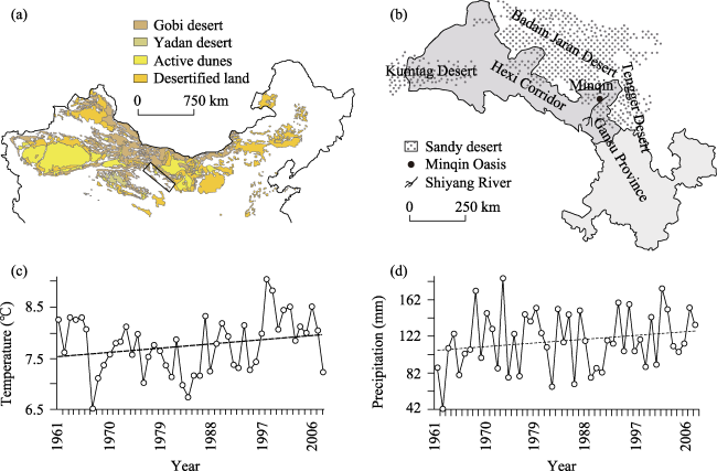
Figure 1 The geographical location of the Hexi Corridor (HXC) in northern China and the related changes in climate parameters of typical desert areas in HXC in 1960-2010
In terms of climate, the Hexi Corridor lies in the center of the temperate desert zone in the mid-latitudes of the NH. Except for the forests and grasslands in the middle and high mountains in the south, most of it has a desert climate and develops corresponding desert landforms. The main types of desert landforms are gobi deserts and sand deserts, which account for about 46.6% of the total area of the region.
Aeolian landforms such as sand dunes or dune fields in the Hexi Corridor are mainly distributed in the corridor between the Qilian Mountains to the south, the Heli Mountain to the north, the Wushaoling to the east, and the ancient Yumenguan to the west. Compared with the dune landforms in the Badain Jaran and Tengger deserts in the neighboring areas, where sand dunes of the two deserts are often centralized in terms of spatial distribution, while those in the Hexi Corridor are different. Almost all the dunes here are scattered, mainly distributed in the areas along river channels, such as oasis and gobi deserts.
The total area of dune fields in the Hexi Corridor is about 754 km2 (Zhu et al., 1980), and there are a large number of high crescent-shaped dunes and crescent-shaped dune chains at the edge of oasis. The Minqin Basin is a typical area with sand dunes developed in the Hexi Corridor. It is located at the lower reaches of the Shiyang River and the western edge of the Tengger Desert. The annual average precipitation is about 116.4 mm and the annual average temperature is about 7.8℃ (Figure 1). The annual average wind speed is about 2.25 m/s.

2.2 Analysis methods and data

Many researchers have systematically investigated different types of sand dunes such as crescent-shaped dunes, crescent-shaped dune chains, pyramid dunes, parabolic dunes, and longitudinal dunes in different areas of the Hexi Corridor, and obtained their geomorphological parameters and characteristics based on field observations and satellite remote sensing image data in different periods (Zhang and Dong, 2014; Chang et al., 2016b, 2017; Lang et al., 2017; Lv et al., 2021). The geomorphological parameters of some crescent-shaped dunes and other types of dunes are shown in Table 1 and the research results of Nottebaum et al. (2015).
Table 1 The locations, heights, movement directions, and lengths of different sand dunes in the Hexi Corridor (Chang et al., 2016b, 2017)
Dune type Dune ID Geographic location Height of dunes
(m, ±0.2 m)
Movement direction of dunes (Cartesian coordinate system, 0° east) NEFS* length
(m, ±0.5 m)
Latitude (N) Longitude (E) Upwind NEFS* Downwind NEFS*
Crescent- haped dunes 1 38°37'52'' 102°55'16'' 9.8 48 438.5 252
2 38°38'00'' 102°55'13'' 11.2 48 163.3 492.7
3 38°36'06'' 102°55'05'' 9.5 48 129.2 163.3
4 38°37'51'' 102°55'02'' 3.7 48 304.2 484.1
5 38°32'11'' 102°56'34'' 7.9 45 271.7 229.4
6 38°31'59'' 102°56'43'' 7.6 46 762.3 430.1
7 38°25'47'' 102°54'37'' 3.9 45 295.9 80.8
8 38°25'17'' 102°52'56'' 5.9 87 42.6 52
9 39°57'41'' 98°49'44'' 5 51 350.4 254.5
10 39°58'07'' 98°49'59'' 2.6 54 222.8 437.9
11 40°00'41'' 98°49'18'' 7.2 57 184.6 197.3
Chains of crescent- haped dunes 12 38°37'46'' 102°54'53'' 6.4 54 726.9 752.8
13 38°37'48'' 102°55'55'' 5.8 54 443.4 406.7
14 38°37'24'' 102°54'46'' 11.1 50 794.8 658.4
15 39°57'59'' 98°51'17'' 13.8 53 413.6 361.1
16 39°57'31'' 98°51'31'' 8.7 54 501.8 466.2
17 39°58'50'' 98°48'04'' 9.6 53 554 445
Pyramid dunes 18 40°05'16'' 94°42'23'' 25.8 SW-NE - -
19 40°05'14'' 94°42'10'' 90.3 SW-NE - -
20 40°05'11'' 94°41'47'' 76.6 SW-NE - -
21 40°05'11'' 94°40'53'' 121.8 SW-NE - -
22 40°05'09'' 94°40'43'' 114.1 SW-NE - -
23 40°05'24'' 94°40'12'' 88.9 SW-NE - -
Parabolic dunes 24 38°36'27'' 102°57'15'' 4.6 - 286.1 35.3
25 38°36'26'' 102°57'42'' 4.4 - 228.9 188
26 38°36'10'' 102°58'15'' 3.3 - 133.3 198.5
27 38°37'08'' 93°59'40'' 3.7 - 396 302.2
28 41°35'64'' 98°41'36'' 4.4 - 59.9 0
29 40°08'51'' 98°41'20'' 4.1 - 15.7 17.7
Accumulated sand-belts (longitudinal dune-belts) 30 38°47'57'' 103°12'36'' 15.2 - 70.4 -
31 38°48'36'' 103°13'30'' 17.1 - 44 -
32 39°02'12'' 103°32'03'' 18.6 - 811.7 -
33 39°02'10'' 103°31'29'' 5.6 - 707.7 -
34 39°02'34'' 103.29°49'' 12.2 - 1557.6 -
35 39°02'20'' 103°26'19'' 9.4 - 207.1 223.4

*Notes: NEFS, an area with non-erodible flat surface that is in front or back of the dune; Upwind NEFS, an area with non-erodible flat surface that is in front of the dune; Downwind NEFS, an area with non-erodible flat surface that is back of the dune.

In addition to the above-mentioned intuitive investigation of geomorphological parameters, quantifying the structure of near-surface sand-bearing airflow and the movement rate of sand dunes is also the most direct and effective means to explore the dynamic changes of sand dunes and their geomorphological evolution (Dong et al., 1998; Chen and Liu, 2011; He et al., 2012; Dong and Huang, 2013; Wang J et al., 2013; Hu et al., 2016; Mao et al., 2016). There are usually two methods for studying the moving speed of sand dunes. One is in-situ high-resolution observation (MDCES, 1975; Dong et al., 1998; He et al., 2012; Lv et al., 2021;) and the other is interpretation based on remote sensing images (Chen and Liu, 2011; Dong and Huang, 2013; Mao et al., 2016). Research work based on the above two methods has been widely carried out in the dune fields of the Hexi Corridor. On this basis, this paper will integrate and sort out the multiple-parameter observation data of sand dunes in the Hexi Corridor and discuss its geomorphological evolution.
In addition, the grain-size sedimentological characteristics of aeolian sediments are also an important aspect in understanding the formation and development of sand dunes (Bagmold, 1959; Pye, 1987; Goudie, 2002; Lancaster et al., 2013). This is because the grain size parameters of sediment particles can be used not only to identify the depositional environment of sediments (i.e., aeolian, alluvial, diluvial, fluvial, lacustrine, glacial, or other facies created by different forces such as wind, water, glacier and so on), but also to identify the transportation form of the sediments (creep, saltation, or suspension). In aeolian geomorphology, saltation is considered to be the most significant of the three basic forms of sand movement blown by wind. At present, research work has been carried out extensively on the grain-size sedimentology of aeolian sediments and related deposits in the Hexi Corridor, such as alluvial/diluvial fan sediments, lacustrine sediments, fluvial sediments, etc. (Zhu and Yu, 2014; Zhu et al., 2014; Zhang and Dong, 2015; Zhang et al., 2016; Pan et al., 2019; Zhang et al., 2020). On this basis, the sedimentological data are collected and sorted systematically in this study and then a sedimentological comparison of sand dunes in different areas of the Hexi Corridor is carried out.
Erodible clastic sediments and their provenance are the material basis for the formation of sedimentary landforms (Pettijohn et al., 1972; Taylor and McLennan, 1985). Therefore, identifying the provenance of aeolian sediments in an arid environment is a prerequisite for understanding the formation of dune landforms (Zhu et al., 1980, 1981; Yang et al., 2012). Among the methods of source-sediment identification, elemental analysis based on the geochemical composition of clastic sediments, such as trace and major element composition including rare earth elements, has become a reliable method to detect the source materials of desert sediments (Muhs et al., 1995, 1996; Pease et al., 1998; Honda and Shimizu, 1998; Wolfe et al., 2000; Pease and Tchakerian, 2003; Zimbelman and Williams, 2002; Muhs, 2004; Yang et al., 2007; Zhu and Yang, 2009; Jiang and Yang, 2019). The geochemical differences in the assemblages and concentrations of trace elements such as rare earth elements in different sediments are largely controlled by the parent-rock composition, because some of these elements only exist in specific minerals and are difficult to be lost during transportation (Pettijohn et al., 1972; Taylor and McLennan, 1985). Combining the trace element characteristics (stable and inherent signals of parent rock) with the characteristics of “variation” or “differentiation” of the target sediments under the processes of erosion- and deposition-recycling and chemical weathering indicated by major element and particle size compositions (changeable and secondary signals), we can effectively identify the source material of aeolian sediments. In the Hexi Corridor, preliminary data have been widely obtained in the case studies using geochemical methods of major and trace elements to analyze the compositional characteristics of aeolian sediments (Wang and Wang, 2013; Ren et al., 2014; Pan et al., 2019; Zhang et al., 2020), which provides basic data for this study to comprehensively understand and identify the source materials of different dunes in the study area.
In addition, the continuous meteorological parameter records of different meteorological stations in the Hexi Corridor from 1960 to 2010 are collected. They are not only the basis for this study to explore the regional climatic response to the global change under the background of global warming, but also the basis for discussing the response of aeolian landforms to regional and global climate change, based on the statistical relationship between the geomorphological and climatic parameter data on interannual and interdecadal scales.

3 Analytical results

3.1 Geomorphological parameters and dynamic changes of sand dunes in the Hexi Corridor

From Table 1 and the research results of Nottebaum et al. (2015), it can be seen that the average height of the typical crescent-shaped dunes in the Hexi Corridor is about 6.75 m. The maximum value is 11.2 m and the minimum value is 2.60 m. The average height of other types of typical dunes is distributed between 4.08 m (parabolic dunes, 3.38-4.60 m), 9.23 m (crescent-shaped dune chains, 5.80-13.8 m), 13.1 m (longitudinal dunes, 5.60-18.6 m), and 86.3 m (pyramid dunes, 25.8-121.8 m).
Regarding the dynamic changes of sand dunes in the study area, as early as 1959-1964, the Minqin Desert Control Comprehensive Experimental Station had carried out the positioning observation and study of the sand-bearing airflow in the Hexi Corridor (Zhu et al., 1980; Zhu and Wang, 1992; Wang, 2003; Zhu and Chen, 1994; Zhu, 1999), and the research work continued to carry out relevant research on different areas of the Hexi Corridor in the later period (MDCES, 1975; Zhu et al., 1980; Zhang et al., 2004; Qu et al., 2005; Wang X et al., 2013; Yin et al., 2014; Chang et al., 2016b, 2017; Zhang et al., 2016; An et al., 2019; Chang, 2019; Hu et al., 2020). Based on the above research results, in Hexi Corridor, about 80% of the sand particles in the wind-blown airflow are flowing within the height range of 20-30 cm near the surface, and about half of the sand particles are within the height range of 0.3-0.5 cm near the surface. At a wind speed of 7 m/s, the sand particles within a height of 10 cm account for 75% of the total, and the sand grains within the height of 75-200 cm account for only 0.035% of the total.
Based on the field observation (such as the measurement of ETS, Electronic Total Station) and satellite imagery (Google Earth) data in different periods (Ren et al., 2010; Chang et al., 2016b), the geomorphological parameters and the dynamic change parameters of different sand dunes are obtained in this study, as shown in Table 1.
The average moving speed of the crescent-shaped dunes is about 6.62 m/a. The maximum is 12.5 m/a and the minimum is 1.01 m/a. The average moving speed of the crescent-shaped dune chains is about 6.54 m/a, the maximum value is 8.30 m/a, and the minimum value is 5.34 m/a. Compared with the crescent-shaped dunes, the movement of the crescent-shaped dune chains is relatively slow, and the movement speed changes little. In general, the crescent-shaped dunes and crescent-shaped dune chains in the Hexi Corridor move along the NW-SE direction, the movement direction of the eastern part of the corridor is about N45°-W, and the movement angle of sand dunes increases in the Jinta area in the western part of the corridor (Table 1). The average swing speed at the top of the pyramid dunes is about 6.32 m/a, the maximum can reach 97.4 m/a, and the minimum is 1.14 m/a. The movement direction of the pyramid dunes will also change, but the main movement direction is SW-NE.
In terms of aeolian geomorphology, the geomorphic types of sand dunes can be divided into four categories according to the average moving speed of sand dunes: slow type (≤1 m/a), medium type (1-5 m/a), fast type (6-10 m/a), and ultra-fast type (≥20 m/a) (Wang, 2003). The research results of Shi et al., (2018) indicate that the moving speed of sand dunes in the Hexi Corridor, except for Dunhuang (<1.0 m/a, slow type), is mainly between 1.4-6.2 m/a, which belongs to medium type or fast type.
Judging from the spatial distribution of deserts in the middle latitudes on a large scale, the Hexi Corridor is almost located at the boundary of two kinds of sand dunes in northern China (Figure 2) in terms of moving trend and moving direction of sand dunes, that is, the sand dunes to the east of the Guyumen show a NW-SE or W-E trend, while the sand dunes to the west of the Guyumen (ancient Yumen) show a NE-SW or E-W trend (Figure 2). The reason is that the main prevailing wind direction in northern China in the winter half year is NE-SW or E-W in the west part of the Hexi Corridor, while it is NW-SE or W-E in the east part (Figure 3), that is, the different movement directions of sand dunes between the east and west parts of the study area are consistent with the differentiation of the regional dominant wind directions. The similarity in the spatial distribution pattern between the dune movement trend and the dominant wind direction indicates that the difference in the evolution of the dune landforms between the east and west parts of the Hexi Corridor should be firstly controlled by the regional-scale dominant wind system or the atmospheric circulation pattern, that is, a control by the dynamic forces rather than the source materials. That is to say, in the cause of the dynamic changes of sand dunes, the synthetic wind direction controls the process of sediment transportation near the surface of the region and thus controls the movement trend of sand dunes in the Hexi Corridor.
Figure 2 Sand-flow field and movement direction of sand dunes in northern China (modified from Dong et al., 1998)
Figure 3 Schematic diagram of the main wind direction in sandy deserts of China in the winter half year (modified from Dong et al., 1998)
In this study, the moving speed of sand dunes in the Hexi Corridor is compared with that of other sand dunes in the desert areas of northwestern China. The observation results of several crescent-shaped dunes along the Oil-Transportation Highway in the Taklimakan Desert show that the dune movement from 1991 to October 1992 was 4.81-10.9 m (average 7.29 m), and the dune movement from 1992 to October 1993 is 3.33-8.89 m (average 5.56 m) (Dong et al., 1998), indicating that sand dunes in the Taklimakan Desert are mainly the medium type and fast type in the dune movement speed. According to the interpretation results of the dune moving speed in the Tengger Desert based on high-resolution remote sensing images in 2010, 2013, and 2014 (assuming that the high-resolution remote sensing images can reflect the changes in sand dune locations within a year), the average movement speed of sand dunes in the Tengger Desert from 2010 to 2013 was about 4.36 m/a, and the average movement speed of sand dunes from 2013 to 2014 was about 2.43 m/a (He et al., 2012), indicating that sand dunes in the Tengger Desert are mainly the medium type in the dune movement speed. Study on the moving speed of the crescent-shaped dunes in the Mu Us Desert based on the interpretation of Google Earth image data shows that the movement speed of sand dunes in this desert is between 3.5-9.5 m/a, indicating that sand dunes in the Mu Us Desert are mainly the medium type in the dune movement speed (Wang J et al., 2013). In addition, the width of the Mu Us dunes is significantly related to the horizontal length of the leeward slope of the dunes. During the movement, the width of the dunes and the horizontal length of the leeward slope of the dunes decrease, while the horizontal length of the windward slope of the dunes increases. There is a good correlation between the moving speed and the width of the dunes (Wang J et al., 2013), indicating that the dynamic changes of sand dunes are not only controlled by the dynamic forces of the wind system, but also controlled by the morphological factors of the dunes themselves.
Compared with the above-mentioned dynamic processes of sand dunes in different sandy deserts of northern China, the dynamic changes of the crescent-shaped dunes in the Hexi Corridor also have obvious spatial differences. From 2006 to 2015, affected by factors such as wind speed and strong wind days, the sand dunes at the edge of the oasis in the Minqin area moved the fastest, with a moving speed of about 6.2 m/a. Affected by the main wind direction and other factors, the sand dunes at the edge of the oasis in the Dunhuang area moved the slowest, with a moving speed of about 0.8 m/a. Affected by different meteorological factors, compared with 2006, the horizontal length of the windward slope of sand dunes in most areas of the Hexi Corridor increased in 2015, while the horizontal length of the leeward slope decreased (Shi et al., 2018). It can be seen that the main factors affecting the dynamic changes of sand dunes in the Hexi Corridor are annual average wind speed and annual strong wind days. Therefore, meteorological (or climatic) factors have an important impact on the dynamic changes of sand dunes in the Hexi Corridor.

3.2 Grain-size sedimentological characteristics of sand dunes in the Hexi Corridor

Based on the results of grain-size sedimentology of different aeolian sediments and related sediments, such as alluvial/diluvial, lacustrine, and fluvial sediments in the Hexi Corridor (Zhu and Yu, 2014; Zhu et al., 2014; Zhang and Dong, 2015; Zhang et al., 2016; Pan et al., 2019; Zhang et al., 2020; Zhu et al., 2022), the sand dunes in different areas of the Hexi Corridor have different grain size compositions, that is, there are obvious spatial differences in grain size of dune sands. This reflects the different source materials and transportation modes of sand dunes in their formation and development.
In the Jiuquan-Gaotai area in the middle part of the Hexi Corridor, the grain size parameters (mean value, standard deviation, skewness, and kurtosis, etc.) of sand dunes in different geomorphic parts such as the sharp corners of the windward and leeward slopes, surface of the slopes, and top of the slope show that most of the particle size frequency curves of sediment materials on the surface of dunes (referred to as dune surface sands) are unimodal distribution, and a few are bimodal (Zhang and Dong, 2015). The dune surface sands are mostly fine sand and very fine sand, with an average particle size of 0.07± 0.01-0.24 ± 0.06 mm, which is similar to the average size of sand dunes in the world’s desert. Like most deserts in China, the dune sands here also have the characteristics that the finer the particle size is, the better the sorting, and the average grain size increases with the increase of the skewness value and decreases with the increase of the kurtosis value (Zhu et al., 2014). From the upwind to the downwind, the dune sands become finer, the medium sand fraction decreases, and the fractions of fine sand, very fine sand, silt, and clay increase. According to Sahu’s granularity discrimination function (Sahu, 1964) and the above grain size parameters, it can be identified that the sedimentary environment of the clastic sediments in the study area mainly includes three types of facies, i.e., aeolian facies, lacustrine facies, and alluvial-diluvial facies, of which aeolian facies dominates (about 50%) (Zhang and Dong, 2015). In the study area, there are three types of grain size distribution patterns on the unit scale of sand dunes: the sands of the dune top are coarser (sands of the slope and inter-dune land are finer), the sands of the dune top are finer (sands of the slope and inter-dune land are coarser), and there is no significant difference among the top, windward slope and leeward slope of the dune (Zhu and Yu, 2014; Zhu et al., 2014; Zhang and Dong, 2015). Among them, the coarser top is the most common type (69% of all dunes), and the finer top is the second common one (24%) (Zhang and Dong, 2015).
The grain-size sedimentological study of the crescent-shaped dunes developed on the gobi areas and the ancient lake plains in the Jinta-Jiayuguan-Huahai area in the central and western parts of the Hexi Corridor shows that the grain size of surface sands of the crescent-shaped dunes is mainly medium sand (21.7%-57.4%), followed by fine sand (23.2%-53.0%) (Pan et al., 2019). The average grain size is 0.27-0.43 mm, which is obviously coarser than the ancient lacustrine sediments (0.10-0.21 mm) (Pan et al., 2019), indicating that the palaeo-lake deposits in this area are not the source of the main particles of dune sands. In comparison, the average grain size of dune sands in this area is larger than that in the Jiuquan-Gaotai area in the central-eastern part of the Hexi Corridor, and it is also larger than that in deserts of other regions. The grain-size sorting of surface sands of the crescent-shaped dunes here is mainly medium and good, the grain-size frequency distribution curve is nearly symmetrical (unimodal distribution), and the kurtosis is medium. The grain size characteristics of the sand dunes are related to the shape of the dune and the properties of the underlying gobi surface (Pan et al., 2019).
The grain size probability accumulative curve of aeolian sediments has a feature that it is usually displayed as 2-4 independent line segments with different slope values and inflection points, indicating that there are 2-4 movement modes occurred during the transportation process of aeolian sediments (Visher, 1969). The grain size probability accumulative curves of dune sands in the Hexi Corridor basically present a three-segment line pattern, indicating that the dune sands here are dominated by a “saltation” movement mode under the action of wind, and are superimposed with a small amount of particles dominated by “suspension” and “creeping” movement modes. This feature has been observed in sand dunes in different areas of the Hexi Corridor (Zhang and Dong, 2015; Zhang et al., 2016; Pan et al., 2019), including the sand dunes in the lower reaches of the Heihe River Basin (Zhu and Yu, 2014). The above-mentioned unimodal and three-stage distribution patterns of grain-size sedimentology of the sand dunes in the Hexi Corridor suggest that the dune sands are a typical aeolian origin. Its approximately normal-distribution pattern of the unimodal curve is a reflection of “high maturity and homogeneity” in grain-size sedimentology, and is a typical feature of the efficient mixing process after aeolian sorting. To a certain extent, it is a function of the sorting process of wind forces on a longer temporal scale or a larger spatial scale (long distance from source areas) (Zhu and Yu, 2014). The high-efficiency mixing characteristics of dune sands and the high degree of homogenization (normalization) characteristics of grain size of dune sands are obviously not fully explained by the mechanism of “local origin”, because it is difficult for the sediments of local origin (usually diversity in mineralogical and sedimentological compositions for original materials) to achieve high maturity (efficient mixing and high sorting) in grain size sedimentology within a relatively short time and a small transportation distance. Compared with dune sands, the movement modes of the gobi sediments, lacustrine sediments, and fluvial sediments in the Hexi Corridor revealed by the grain-size sedimentology are mainly “creeping-saltation” and “saltation-suspension” modes, respectively (Zhu and Yu, 2014; Zhang et al., 2016), presenting a typical two-stage mode. In addition, the frequency accumulative curves of gobi, fluvial, and lacustrine sediments are usually bimodal or multimodal in shape (Zhu, 2007; Zhu and Yu, 2014; Zhang et al., 2016), and rarely show the unimodal distribution pattern of aeolian sediment, which indicates that the gobi, fluvial, and lacustrine sediments not only move differently from dune sands, but also originate from different sources. The formers are of “in-suit/on-suit” or “local” origin, while the latter has experienced extensive and efficient material mixing and is not of local origin.

3.3 Geochemical characteristics of dune sands in the Hexi Corridor and their indicated sources of sand materials

Regarding the source of dune sands and other aeolian sediments in the Hexi Corridor, the Minqin Comprehensive Sand Control Experimental Station had conducted investigations on the provenance of the sand dunes as early as 1959-1964 (MDCES, 1975; Zhu, 1980; Chang, 2019), and the relevant studies based on different methods have continued to this day (Ren et al., 2010, 2014; Ferrat et al., 2011; Zhang and Dong, 2015; Zhang et al., 2016, 2020; Chang, 2019).
Due to the widespread application of mass spectrometry geochemical methods in recent years, more refined studies of sediment-provenance identification have become possible (Wang L, 2011; Wang and Wang, 2013; Ren et al., 2014; Pan et al., 2019; Zhang et al., 2020). Here, we take the study of sand dunes developed in some representative areas such as the gobi areas in the west and north of the Jiayuguan area in the west of the Hexi Corridor, the Jinta-Gaotai area in the central of the Hexi Corridor, and the Minqin Basin in the east of the Hexi Corridor as examples to explore their source materials based on geochemical evidence.
The Minqin Basin is dominated by an oasis landscape. It is located in the eastern part of the Hexi Corridor, the northern edge of the Loess Plateau (LP), and borders two large sand seas in northern China, namely, the Badain Jaran Desert in the northwest and the Tengger Desert in the southeast (Figure 1). The Minqin Basin is considered as a natural barrier preventing the convergence of these two deserts (Zhu et al., 1980). From a larger scale of geography and geomorphology, determining the source and migration of aeolian sediments in the Minqin Oasis and its adjacent desert areas will help to better understand the relationship between Chinese loess and deserts (Liu, 1985; Sun, 2002; Yang et al., 2011; Ren et al., 2014).
Previous research work has systematically collected aeolian sediment samples such as sand dunes from the Minqin Oasis and its surrounding desert areas. Through mass spectrometry geochemical analysis, combined with regional meteorological wind data and statistical cluster analysis methods, studies have conducted to discuss the spatial distribution characteristics of major and trace elements in dune sands in the Minqin Oasis and its adjacent deserts (Badain Jaran and Tengger deserts), as well as the potential sources and migration pathways of aeolian sands in these areas (Ren, 2010; Ren and Wang, 2010; Ren et al., 2014;). Combined the geochemical data above-mentioned and seen from the major elements compositions of the bulk samples from sand dunes in the Minqin Basin and its surrounding areas (the Badain Jaran Desert B, the Badain Jaran-Minqin transition zone BM, northeastern edge of the Tengger Desert TNE, Tengger-Minqin transition zone TM, southwest of the Tengger Desert TSW), the content of SiO2 is very high, reaching 72.2%-88.9% with an average value of 83.3%. In contrast, the content of most trace elements is relatively low, and only the content of Ba, Ce, Co, Mn, and Sr reaches >100 ppm (Ren et al., 2014). Compared with the average composition of the upper continental crust (UCC, representing the average composition of the unweathered and initial materials in the surface of the continental crust, the data comes from the literature (Taylor and McLennan, 1985)), Ba, SiO2, Rb, Sr, Al2O3 and K2O of dune sands in the Minqin Basin and its surroundings are relatively uniform (Ren et al., 2014), indicating that the spatial difference in the abundance of these elements is not large (relatively homogeneous), while other elements have some obvious changes in enrichment and loss (Ren et al., 2014), indicating that there are large spatial differences in the abundance of these elements (heterogeneous). Since these homogeneous and heterogeneous element compositions represent the similarities and differences in the sources of detrital sediments, respectively, they can be used as good geochemical indicators to identify the different sources of dune sands. In the composition of major elements, only SiO2 is enriched relative to UCC, and the others are relatively deficient. In the abundance of trace elements, most elements are deficient, except that Cr and Ni are enriched in B and BM areas and Cr is enriched in TNE. This indicates that the dune sands in the study area have experienced obvious “changes in the parent source’s information” compared with the original upper continental crust material (source rock). From the spatial distribution of geochemical elements in dune sands, the element binary diagrams of Cr, Ni, Cr/V, Y/Ni, Al, V, Zr, HF, Zr/HF and the ternary diagrams of major and trace elements reveal that the dune sands in the western part of the Minqin Basin (B and BM) and the southeastern part of the Minqin Basin (TSW) have different source materials. The geochemical compositions of the dune sands in the Minqin Basin (M) and the dunes on its southern margin (TM) are related to the two deserts respectively (Ren et al., 2014). These geochemical evidences indicate that the aeolian sands in the Badain Jaran Desert can be transported to the west side of the Minqin Oasis by the northwest wind for a long distance through the Yabulai Mountains, and the aeolian sands in the Tengger Desert provide a sediment source for the eastern part of the Minqin Oasis. However, the aeolian sands of the two deserts cannot directly reach or bypass the other side of the Minqin Oasis (crossing the oasis barrier) to achieve the confluence of the two deserts. This suggests that the sand dunes in the Minqin Basin have multiple sources and the Minqin Oasis is an effective barrier to prevent the migration and convergence of sand dunes between the Badain Jaran Desert and the Tengger Desert. However, the large number of sand dunes occurred in the oasis area of the Minqin Basin also indicates that the role of oasis landscape as an ecological barrier in preventing aeolian sand erosion in arid areas is also limited.
Compared with the east, the major and trace element geochemical characteristics of sand dunes such as the crescent-shaped dunes and others developed in the west part of the Hexi Corridor have also received extensive attention (Pan et al., 2019; Zhang et al., 2017). These dunes are mainly located in the gobi area to the north and west of Jiayuguan. The types of dunes are mainly the crescent-shaped dunes, the crescent-shaped dune chains, and the asymmetric crescent-shaped dunes (Pan et al., 2019; Zhang et al., 2017). After the UU standardization, the crescent-shaped dunes on the gobi surface in the west of the Hexi Corridor are significantly enriched in the major elements Cao and SiO2 (accounting for 5.55% and 66.1% of the bulk sample, respectively). The contents of Cao, MgO, and Fe2O3 are gradually enriched from northwest to southeast, that is, the degree of enrichment increases gradually along the dominant wind direction. The UCC standardized values of Na2O and K2O are significantly less than 1, indicating that alkali metal elements are significantly depleted or leached (Pan et al., 2019; Zhang et al., 2017). The contents of trace elements are different among the sand samples of different dunes, which also reflects the complexity of the provenance of dune sands in the study area. However, in different geomorphic locations of the same dune, the contents of trace elements are relatively similar (Pan et al., 2019), indicating that the trace-element compositions of dune sands are relatively consistent at the inter-dune geomorphological-unit scale. Compared with UCC, most of the trace elements are in a deficit state, except for the significant enrichment of Co, As, La, and Nd. It shows that the sand dunes in the west of the Hexi Corridor are similar to those in the east, and both have undergone significant “variation of parent rock’s information”. Compared with the geochemical elements in the Tengger and Badain Jaran deserts (Li, 2011), the content of SiO2 in the study area is lower, the content of K2O is similar, and the content of other trace elements is lower.
Aeolian sediments such as dune sands from the Jinta-Gaotai area in the central and eastern parts of the Hexi Corridor have also obtained systematic geochemical analysis on major and trace elements (Ferrat et al., 2011; Wang and Wang, 2013; Wang X et al., 2018; Zhang et al., 2020). Comparing the results of different studies, it can be found that the results of geochemical element analysis are similar to those observed based on mineralogical analysis. For example, the dune sands in the study area have similar mineralogical compositions (such as mica, quartz, illite, muscovite, and albite) with the dune sands in the adjacent areas of the Tengger and Badain Jaran deserts (Ferrat et al., 2011), and the analytical results of major and trace elements also reveal this feature (Ren et al., 2014; Zhang et al., 2020). This indicates that the aeolian sediments in the Hexi Corridor and its adjacent areas have a regional-scaled similarity in geochemical and mineralogical characteristics. Compared with the average geochemical composition of the upper continental crust (UCC), the dune sands in the Jinta-Gaotai area are also rich in CaO, which is not only similar to the west part of the Hexi Corridor, but also similar to the fluvial, lacustrine, gobi, and dune sediments near the Taklimakan and Badain Jaran deserts, but they are slightly different from the aeolian sands in the Kumtag and Tengger deserts (Zhang et al., 2020). Based on the multi-dimensional scaling analysis (MDS), principal component analysis (PCA), and regional topographical analysis, it indicates that the Hexi Corridor may not only be a sink of sediments from the Qilian Mountains, but also a sink of sediments from the Beishan Mountains (Zhang et al., 2020).
To synthesize the above geochemical evidence, dried fluvial and alluvial-diluvial sediments are the initial source materials of dune sands in the Hexi Corridor. These detrital sediments are mainly derived from the erosion and weathering of the Qilian Mountains in the southwest and the Beishan Mountains in the north of the corridor. As revealed by the above grain-size sedimentological analysis, sand dunes in the Hexi Corridor have the typical characteristics of aeolian origin, high-efficiency mixing, and high-efficiency differentiation (sorting), their similarities in the compositions of some major and trace elements can be explained. The similarity in the compositions of these materials can also be proved by regional comparisons. For example, comparing the major element abundances of different aeolian sediments in northern China (Table 2), the dune sands in the Hexi Corridor are to some extent both similar to the dune sands in the deserts of northwestern China (such as the Kumtag, Badain Jaran, Tengger, and Taklimakan deserts) and the aeolian loess in the Loess Plateau of China. In addition, the regional comparison results also show obvious local differences. For example, the Fe2O3 content of sand dunes in the Hexi Corridor reaches 3.50%, which is generally higher than other deserts. In addition, the CO content of sand dunes in the Corridor is also significantly higher than that in other regions (Ren et al., 2014). This indicates that the dune sands in the Hexi Corridor are rich in iron and cobalt elements, but the content of other elements is similar to other deserts.
Table 2 The average element contents of sandy dunes in the Hexi Corridor and other deserts and the average composition of the upper continental crust (%)
Regions Fe2O3 CaO MgO SiO2 Al2O3 Na2O K2O References
Hexi Corridor 3.5 5.55 2.07 66.12 9.24 2.45 2 (Zhang et al., 2017; Pan et al., 2019)
Badain Jaran Desert 1.93 2.06 1.19 80.27 7.78 1.9 2 (Zhu and Yang, 2009)
Tengger Desert 1.96 1.3 1.12 80.94 8026 1.88 2.25 (Zhu and Yang, 2009)
Kumtag Desert 2.88 4.64 2.19 70.13 9.59 2.52 1.98 (Dong et al., 2011)
Taklimakan Desert 3.1 7.88 2.2 62.05 10.6 2.58 2.11 (Zhu and Yang, 2009)
Loess (CLP) 4.56 8.62 2.31 58.65 11.86 1.68 2.44 (Dong et al., 2011)
Paleosol (CLP) 5.12 0.83 2.21 65.18 14.79 1.41 3.15 (Dong et al., 2011)
UCC 5 4.2 2.22 66 15.2 3.9 3.4 (Taylor and McLennan, 1985)
Terrestrial shale 7.22 1.3 1.2 62.8 18.9 1.2 3.7 (Taylor and McLennan, 1985)

4 Discussions

4.1 The formation mechanism of sand dunes in the Hexi Corridor

In general, the dune landforms in the Hexi Corridor are dominated by mobile dunes. The formation of these dunes was considered to have three genetic mechanisms in the early research work: (1) sand dunes are formed due to the destruction of the vegetation on the fixed shrub dunes in the oasis areas; (2) the gravel surface of gobi areas and the wind erosion areas in the Hexi Corridor provide abundant sandy sediment sources, which leads to the accumulation of aeolian sands and the formation of sand dunes; (3) due to the changes and diversions of river channels, the abandoned dry riverbeds are blown up by wind and the aeolian sediments accumulated nearby to form sand dunes (Zhu et al., 1980). The formation mechanisms of the above-mentioned aeolian landforms can all explain the characteristics of sporadic or flake distribution of sand dunes in the Hexi Corridor, especially the distribution characteristics of sand dunes in the gravel gobi areas, which are often distributed intermittently and meanderingly along the dry riverbed and scattered on the edge of the oasis near the gobi areas. From the perspective of spatial scale, the above three formation mechanisms of dunes can all be regarded as “local or in-suit forcing” mechanisms. However, with the deepening of research in recent years, compared with desertification in other parts of northern China, some scholars believe that the change in the amount of water resources transported downstream and controlled by the glaciers and snow in the Qilian Mountains, namely, water supply in the source area, is the key factor for the formation and evolution of sand dunes and the desertification in the Hexi Corridor (Xie et al., 2004). In addition, some studies have suggested that the weakening of large-scale wind activity in northern China and even the NH and the acceleration of regional water cycle (increasing water supply) jointly restrict the dune dynamics and desertification process in the Hexi area (Wang et al., 2002; Wang et al., 2008a; 2008b).
Taking a further comprehensive view, the above-mentioned formation mechanisms of dune landforms, whether on local scale, regional scale, or even hemispheric scale, can be attributed essentially to a natural mechanism, that is, the sand dunes in the Hexi Corridor are of natural origin. However, even such a simple point of view has been questioned a lot (Wang et al., 2006, 2008a). Many researchers believe that the formation of sand dunes in the Hexi Corridor is not all controlled by the influence of natural factors, and many sand dunes should have been formed during historical periods and are the result of human activities (Zhu et al., 1980; Zhu and Chen, 1994; Zhu, 1999; Yang et al., 2004; Chang et al., 2005; Li, 2007). For example, at present, some ruins and the sites of Great Wall of the Han, Tang, and Ming dynasties can be seen in some dune fields of the deserts, such as the Nanhu- Shouchang ruins in the Dunhuang area, the ruins in dune fields of the ancient Xicheng Post Station in the west of the Zhangye area, and the Ming-dynasty Great Wall ruins in dune fields of the Minqin area (Zhu et al., 1980; Zhu and Chen, 1994; Zhu, 1999).
From the above, there are at least two issues regarding the dune landforms in the Hexi Corridor and currently there is no consensus among the academic circles. On the one hand, since the formation of dune landforms is essentially the result of aeolian accumulation (not erosion), based on the understanding of the aerodynamical process and the mass balance principle, the upwind gobi area in the west of the Hexi Corridor, as a wind erosion area and with its wind erosion products, has always been considered as one of the reasons for the dust activities and aeolian landform changes in the downwind central and eastern parts of the Hexi Corridor (Zhu et al., 1980; Wang X et al., 2013; Zhang et al., 2016), because the former may provide the material basis (sand source) for the formation of sand dunes in the latter. However, the above evidence from grain size sedimentology and geochemistry shows that the dune sands in the central and eastern parts of the Hexi Corridor are not only multi-sourced, highly mixed, and homogeneous in terms of sediment provenance, but also related to the expansion of the large-scale outer deserts and the erosion and weathering of the north and south mountains. So, can the desertification in the central and eastern parts of the Hexi Corridor be only explained by wind-erosion in gobi areas and existence of the late glacial deposits in the western part of the Hexi Corridor? In other words, is desertification in the west driving the central and eastern in the Hexi Corridor? Secondly, in the past half century, are the dynamic changes of sand dunes in the Hexi Corridor mainly driven by natural or man-made causes? In view of these two issues, some preliminary discussions are made below.

4.2 Desertification in the Hexi Corridor: driven by the west?

In fact, as mentioned above, the movement of sand dunes between the west and east of the Hexi Corridor has different directions on a large scale (Figure 2), which is roughly consistent with the prevailing wind direction of the sub-region (Figure 3). This indicates that the dynamical pattern of dune movement between the two sub-regions is coupled with the pattern of the dominant winter-spring atmospheric circulation between the two regions, that is, in terms of the dynamical mechanism, the synthetic wind direction controls the sediment transportation process near the land surface and thus controls the dynamical evolution of sand dunes. Therefore, the dynamical evolution of sand dunes between the west and east of the Hexi Corridor is in a decoupled relationship in terms of the law of evolution of aeolian landforms. Therefore, the difference of wind systems determines that the desertification in the Hexi Corridor should not have the dynamical mechanism of “the west driving the east”.
In addition, regarding the aspects of eroded-sediment transport and mass balance, many studies have been carried out on the surface soil, wind-erosion (deflation) landforms, and wind erosion potential of the gobi areas in the west of the Hexi Corridor (Zhu et al., 1980; Zhang K et al., 2004; Qu et al., 2005; Wang X et al., 2013; Yin et al., 2014; Zhang et al., 2016; An et al., 2019), in order to explore the evolution of regional landforms from the perspective of the coupling process between erosion and accumulation and the basis of mass balance between sediment-erosion loss and source-sediment supply. As the potential sediment transport quantity (the erodibility of surface fine particles), the gravel coverage (surface roughness), and the average grain size of surface sediments are the main factors affecting dust emissions (Pye, 1987; Gillette and Stockton, 1989; Raupach et al., 1993), the three factors determine whether the erodibility of the gobi surface sediments in the west of the Hexi Corridor has a potential contribution to desertification in other regions of the study area.
From the perspective of the erosion process, wind-eroded sites are widely distributed in the western part of the Hexi Corridor, and wind erosion on the surface has formed long strip-shaped wind-eroded mounds and wind-eroded depressions roughly parallel to the wind direction. These wind-eroded landforms are generally about 1-3 m high and a few are up to 5 m (Zhu et al., 1980), which are roughly distributed along the lower reaches of the Shule River and the western part of the Dunhuang oasis. The existence of this type of eroded landforms indicates that the gobi area in the west of the Hexi Corridor has potential conditions of source material supply for the formation of aeolian landforms in the downwind area. However, from the perspective of the erodibility of surface clastic materials, the study on the surface properties of the gravel gobi in the west of the Hexi Corridor and its impact on dust emission shows that there is an obvious difference between gravel gobi desert and sandy desert (dune field), which is that the grain size composition of surface sediments and the sedimentary state (erodibility) of fine particles are completely different (Zhang K et al., 2004; Yin et al., 2014; Zhang et al., 2016; Hu et al., 2020). The surface of the gobi is usually composed of gravel, sand, fine sand, silt, and clay materials, and the coarse and fine materials are mixed, while the dune sediments are mainly composed of medium sand, with no or few coarse-grained gravel, fine-grained silt, and clay materials (Zhang et al., 2016; An et al., 2019). In addition, most of the surface of gobi areas has salt crusts, fine particles are consolidated due to the presence of cements (calcium carbonate, etc.), and the wind erodibility here is weak, while dune sands are generally loose and highly erodible (Zhang et al., 2016).
In addition, based on field surveys and high-resolution image data analysis using ImageJ software, some studies (Zhang et al., 2016) estimated the gravel coverage and the state of surface salt crusts in different Gobi areas in the west of the Hexi Corridor. The proportion of the total weight of gravel (diameter >2 mm) in surface sediments and the grain size distribution of different surface sediments in the gobi areas were also determined. The research results show that: (1) the gravel coverage on the gobi surface is dominated by medium coverage, which is mainly between 40% and 70% (average 52%, SD = ±17%) in the west of the Hexi Corridor. Previous studies have proved that the proportion of gravel in this numerical range can completely produce the maximum aerodynamic roughness on the surface (Lyles and Tatarko, 1988; Wolfe and Nickling, 1996; Dong et al., 2002a, 2002b; Liu and Dong, 2003; Uno et al., 2006; Rostagno and Degorgue, 2011) and prevent the emission of dust. (2) Salt crusts are formed between the surface gravel particles in most of the gobi areas (accounting for 75% of the area) and only the areas with high sediment transportation potential and the edge of sandy desert in the north of the Hexi Corridor have no surface crusts. (3) The content of erodible materials (sand, silt, and clay) on the gobi surface has a clear spatially differential distribution. The gravel surface sediments are mostly medium sand and fine sand (accounting for 52.5% and 25.0% of the total, respectively). While the content of silt and clay is 9.8% to 40.1% and most of the content (about 73% of the samples) is between 10% and 30%. (4) In most of the gobi areas, the potential erodible sand materials can migrate more than 200 vector units, but 75% of the ground surface in these areas has solid soil crusts, which are difficult to migrate (Zhang et al., 2016).
Based on the above analysis, the quantitative indicators such as the proportion of fine-grained dust, the coverage rate of surface salt crusts, and the potential migration of sand sediments all indicate that the high gravel coverage and surface crust rate in the gobi area can effectively reduce the dust emission and sand sediment migration on the surface. Therefore, on the material basis, the gobi area in the west of the Hexi Corridor should not be the main source area of dust storms in the central and eastern parts of the Hexi Corridor, while the north of it may be the main source area of dust. Therefore, from the perspective of dynamical mechanism and material basis, the western part of the Hexi Corridor cannot meet the conditions that drive desertification of the central and eastern parts of the Hexi Corridor.

4.3 Potential factors influencing desertification in the Hexi Corridor: climate warming?

To characterize the desertification process of a region, in addition to understanding the geomorphic parameters and their dynamic changes of sand dunes, there is another potential index that can be used to indicate the degree of regional desertification. It comes from the dust storm process in meteorological events, such as the strong wind days and dust storm days (Chang, 2019). Dust storm refers to a kind of windy and dusty weather phenomenon with the wind speed ≥ the onset sand-blowing wind speed and the horizontal visibility <1000 m.
In meteorology, the Hexi Corridor is considered to be one of the frequent occurrences of dust storms and strong wind days in northwestern China (Zhu and Chen, 1994; Zhu, 1999). From the meteorological data of the Hexi Corridor for nearly half a century (Chang et al., 2011, 2015), since 1956, the number of local dust storm days in the Hexi Corridor is about 11.2 d/a (days/a year), and the average number of strong wind (>grade 8) days is about 18.4d/a (Chang et al., 2015), but the dust storm events generally show a decreasing trend, with a decreasing rate of 0.68 times/a. In the past half century, the number of dust storm days in the Hexi Corridor (such as the Minqin area) has generally shown a decreasing trend, and there are three trends of change during this period, namely, the frequency and times of dust storms decreased rapidly (1956-1969), the frequency was high and stable (1971-1987), and the frequency was low and slowly decreased (1987-2008) (Chang et al., 2011).
From the comparison of large-scale spatial scope, the frequency of dust storms throughout northern China is also decreasing during the same period (Zhang and Ren, 2003; Li and Zhang, 2007). But on a global scale, it is opposite to the occurrence of global dust storms, because the number of global dust storm events has been increasing in recent decades due to global warming (Houghton et al., 2001; Ding, 2002a). This indicates that the dust storm process in the Hexi Corridor and even the entire area of northern China did not respond to global dust storm changes. The causes of dust storm events or potential desertification processes here may be different from those in other parts of the world.
Over the past half century, the temperature in the desert areas of the Hexi Corridor has gradually increased (Chang et al., 2011), which is consistent with global warming. This suggests that the climate of the study area is responding to global climate change. However, under the background of global and regional warming, why has the frequency of dust storm events in the Hexi Corridor not increased like the global dust storms, but has decreased? Isn’t climate warming the leading factor? To answer this question, it is also necessary to analyze the changes of climate with multiple meteorological parameters in northern China and even the Hexi Corridor since this period. That is, under the background of increasing temperature, how does the regional climate in the desert areas of northern China and the Hexi Corridor change and respond to global warming?
Regarding the issues of regional climate change in the mid-latitudes over the past half century, studies have been carried out in arid regions of northern China and the Hexi Corridor (Ding, 2002; Sha et al., 2002; Ding, 2002b; Chang et al., 2011; Chang et al., 2016a), which are briefly summarized as follows. (1) From 1961 to 2008, the annual average temperature in the Minqin area increased. The rate of increase was higher than the rate of global temperature increase in the 20th century and the rate of temperature in China increased in recent 100 years. Among them, the temperature increase in February was the largest and the monthly average temperature increased by 3.01°C. (2) From the 1980s to the 1990s, which was the warmest in the world in the 20th century, the extreme maximum temperature in the Minqin area increased significantly, while the extreme minimum temperature decreased intermittently. The instability of the extreme maximum temperature and the extreme minimum temperature increased in this period. The main manifestations are that the instability of the monthly average temperature in January and April has increased, the isothermal date in February is 10.36 earlier, the instability of the extreme maximum temperature in December and January has increased, and the variation coefficient of the extreme minimum temperature in May has reached 287%. (3) From 1961 to 2008, while the temperature in the Minqin area increased, the precipitation also showed an increasing trend, and the air humidity also increased significantly. (4) The instability of precipitation in January increased and the stability of annual precipitation increased in the Minqin area. (5) Overall, like the large-scale regional climate change in northern China, the problem of temperature instability in the Minqin area should be more worthy of attention than the problem of temperature warming (Ding, 2002; Sha et al., 2002; Ding, 2002b; Chang et al., 2011; Chang et al., 2016a). (6) From 1961 to 2008, the wind speed in the Minqin area continued to decrease. (7) There is a significant negative correlation between the multi-year and seasonal distributions of dust storms and the relative humidity of the air.
It can be seen from the above that although the temperature in the Hexi Corridor has increased (in response to global warming), the precipitation has increased (in response to the strengthening of the Asian summer monsoon), the relative humidity of the air has increased and the wind speed has decreased. As a result of these environmental changes, on the one hand, the driven force of the dust emission process will decrease (because the wind speed is reduced). On the other hand, the viscosity of sandy land surface will increase (because the humidity is increased), and the consequence will lead to the decrease in the frequency of dust storm events. Therefore, the decrease of dust storm days in the Hexi Corridor since 1961 is mainly due to the weakening of wind system and the increase in relative humidity of the air, that is, the windless, warming and humidification of the local climate is one of the important reasons for the reduction of dust storm. In other words, the Hexi Corridor has a potential inverse desertification trend in the past half century and one of its controlling factors is the climate change on a local scale.

4.4 Desertification in the oasis areas of the Hexi Corridor: natural or human factors?

The regional desertification in the Hexi Corridor has been in an inverse desertification trend for nearly half a century and is controlled by natural factors. However, is this also the same for the local desertification widely occurred in the oasis area of the Hexi Corridor?
In fact, the problem of oasis desertification in the Hexi Corridor is far more concerned than the problem of regional desertification. For more than half a century, the local government and organizations have systematically carried out the constructions of desertification control projects and the theoretical environmental research in response to the problem of oasis desertification in the Hexi Corridor. This is particularly significant in the ecological control of desertification, such as the study of the water physiology and ecology of desert xerophytes, the study of phenology of desert plants, and the study of sand accumulation at the edge of oasis (Zhu and Chen, 1994; Zhu, 1999). Over the past half century, with regional climate change and landform changes (desertification), the natural environment of oasis areas in the Hexi Corridor has also undergone great changes, which are prominently manifested in two aspects: the water environment and the vegetation/ecological environment, such as:
(1) The groundwater level in the Hexi Corridor has generally declined and the regional water resources have decreased. For example, the 26 motorized wells in the central and marginal areas of the Minqin Oasis showed that from 1985 to 2001, the decline rate of groundwater level in the central part of the Minqin Oasis reached 0.54 m/a (Chang, 2019). While the motorized wells at the edge of the Minqin Oasis indicated that the decline rate of groundwater level at the edge of the Minqin Oasis reached 0.56 m/a from 1985 to 2017 (Chang, 2019).
(2) The area of natural forest in the Hexi Corridor has declined. Due to the decline of groundwater level, the natural sand-fixing vegetation in the Minqin area has declined on a large scale, and the desert grasslands have become desertified. For example, the area of natural sand-fixation forest in the Minqin area was 203,951 hm2 in 1981, but the area of natural sand-fixation forest had been reduced to 197,353 hm2 by 2002 (Chang, 2019). In the early 1980s, there were 373 hm2 of Populus euphratica forests in Minqin, but they have now disappeared (Chang, 2019).
The above-mentioned changes in the ecological environment and groundwater environment indicate that the reason for the continuous reduction of vegetation in the oasis areas of the Hexi Corridor is neither the change in regional precipitation or relative humidity, nor the lack of afforestation, but the change of “effective moisture” of groundwater and soil water in the oasis (Chang, 2019). This suggests that the causes of regional desertification and local desertification in oasis areas are different in the Hexi Corridor.
As mentioned above, the dynamic changes of sand dunes in the Hexi Corridor are partially controlled by annual precipitation, that is, the regional desertification is partially controlled by the relative warming and humidification of the climate. Therefore, it can be said that in the Hexi Corridor, regional desertification is partially controlled by the “effective moisture” (relative humidity) of the atmosphere, while desertification in the oasis area is controlled by the “effective moisture” of the soil. In other words, effective and available water is the most restrictive factor in the oasis environment. Specifically, this effective water is neither atmospheric precipitation nor surface water, but soil water and groundwater.
In the past half a century, despite global warming, the climate of the Hexi Corridor in the mid-latitude arid zone becomes relatively more humid, not “the wet get wetter and the dry get drier” under the background of global warming (Greve et al., 2014; Feng and Zhang, 2015; Jensen et al., 2019). However, the humidification of the regional climate in the Hexi Corridor is obviously inconsistent with the degradation of groundwater (Chang, 2019) and the decline of natural forests in the oasis area during the same time. This indicates that the desertification in the oasis area of the Hexi Corridor is controlled by the influence of human activities, rather than the influence of natural factors.
Based on the above analysis, in the Hexi Corridor and the mid-latitude arid zone of northern China and even the world, the prevention and control of desertification in oasis area should follow the “balance of effective soil moisture” as the center. The rational utilization of groundwater is the key to the prevention and control of desertification in oasis areas (Chang, 2019).
Based on the above, changes in the water environment are an important factor restricting the desertification of oasis in arid regions. The degradation process of the ecological environment in the Minqin area of the Hexi Corridor is a good example. On a larger spatial scale, water resources are generally insufficient in the arid and semi-arid areas of northern China, so all the oasis landscapes may face similar and potential desertification problems.
At present, some studies believe that water transfer from outer river basins (such as the Yellow River Basin and the Yangtze River Basin) can appropriately alleviate the serious water shortage and desertification problems of the inland river basins in the Hexi Corridor. However, judging from the large-scale resource allocation in arid areas, firstly, water transfer from outer basins may not be the fundamental solution to the problem of water shortage in arid areas. This is because the water shortage in arid areas of the mid-latitudes is caused by the changes of the Cenozoic global cooling in geological period, the mid-latitude monsoon-westerly atmospheric circulation adjustments, and the changes in global ice volume and sea level variations. Therefore, it may be a permanent water shortage on the Anthropocene time scale. Secondly, water transfer from outer basins is likely to cause ecological problems in other basins, because almost every basin in an arid environment is short of water or is potentially short of water. Thirdly, large-scale water transfer may also be economically unrealistic. Due to the constraints of socio-economic conditions (such as the problem of water charge) and financial resources in the Hexi Corridor, at least water diversion from the outer basins is not feasible in the near future. Fourthly, under the background of the unsaturated state of the soil water (namely not under the stress of salt accumulation), or avoiding the occurrence of the next water environmental problem such as the Aral Sea Ecological Crisis (Micklin, 2007), the Loulan Ecological Crisis (Mischke et al., 2017), or the local “Qingtu Lake Ecological Crisis” (Chunyu et al., 2019) in the mid-latitude arid area due to the accumulation of salt and the diffusion of aeolian saline soil, there is still a lack of understanding on how to achieve regional water environment security (salinization issues) and effectively replenish soil water and groundwater rather than surface water by transferring water from other river basins. In addition, the inland river basins of the Hexi Corridor are not an absolute “resource-based water shortage”, but the coexistence of “resource-based water shortage” and “technology-based water shortage” (Chang and Liu, 2003). This means that comprehensive prevention and control are necessary measures for the prevention and control of desertification in the oasis of the Hexi Corridor.

5 Conclusions

The formation and dynamic changes of dune landforms in the Hexi Corridor are typical land desertification problems in the mid-latitudes of the NH. Study on the formation and evolution of aeolian dune landforms in this area is of great significance for revealing the mechanism of local desertification process and regional environmental change. Previous opinions were mostly based on the understanding of changes in the natural background on long-term scales such as the geological and historical level. In the past half century, what are the characteristics of aeolian sand landforms and dust activities in the Hexi Corridor, whether they respond to regional or global climate changes, whether the upwind gobi area is the source area and the engine area of dust storms in the downwind central and eastern areas of the corridor, and how do natural and human factors affect the process of regional desertification? The academic circles still lack a comprehensive understanding on these questions.
The results of this study show that in the past half century, the typical crescent-shaped dunes and chains of crescent-shaped dunes in the study area have moved or swung on the interannual and interdecadal scales. The dynamic changes of the dunes are mainly affected by the annual average wind speed and annual strong wind days, indicating that the primary influencing factor of the dynamic changes of sand dunes is the climatic factors. The grain size frequency accumulation curve of sand dunes in the Hexi Corridor basically presents a three-stage model, which is obviously different from the two-stage model of gobi sediments, indicating that the former has experienced efficient processes of wind differentiation and mixing and is not of local origin, while the “immaturity” of the latter in sedimentology indicates that it is of “in-situ/on-site” or “local” origin. Paleogeographical, sedimentological, and geochemical evidence indicate that the source materials of dune sediments in the Hexi Corridor are mainly alluvial/proluvial deposits and ancient fluvial sediments, including ancient lacustrine deposits, clastic deposits in the denudation zone of the north and south piedmonts, and aeolian sands from surrounding sand seas. In terms of major and trace element compositions, the crescent-shaped dune sands in the Hexi Corridor have certain similarities and differences with the dune sands and aeolian loess in desert areas of northern China, indicating the high-efficiency mixing characteristics of aeolian sediments. In general, dune sands in the Hexi Corridor are relatively rich in iron and cobalt elements. Considering the proportion of surface fine particles, the coverage of surface salt crust, and the content of erodible sandy materials, the gobi area in the west part of the Hexi Corridor is not the main source area of dust storms occurred in the central and eastern parts of the corridor, while the northern part may be the main dust source area. Over the past half century, the warming and humidification of the regional climate in the study area is a synchronous response to global climate change and the strengthening of the Asian summer monsoon. The weakened wind system is the main reason for the reduction of dust storms (weakening of dust activities) in the study area. During the same period, the Hexi Corridor has a potential reverse desertification trend on a regional scale, which is also controlled by climate change rather than human activities. But in the oasis areas, the desertification process is still controlled by groundwater changes under the influence of human activities.
[1]
An F, Zhang D, Zhao J et al., 2019. Physical and chemical properties of soils in different types in the Gobi areas of the Hexi Corridor. Soil and Water Conservation in China, (6): 42-47. (in Chinese)

[2]
Bagnold R A, 1959. Physics of Sand and Dunes in Desert. Beijing: Science Press.

[3]
Chang Z, 2019. Problems and solutions to desertification combating in the Hexi, Gansu for 60 years. Journal of Arid Land Resources and Environment, 33(9): 152-159. (in Chinese)

[4]
Chang Z, Han F, Zhong S, 2005. Natural and artificial factors and their transfer on sandy desertification of lower reaches of Shiyang River Basin. Arid Land Geography, 28(2): 150-155. (in Chinese)

[5]
Chang Z, Han F, Zhong S, 2011. Response of desert climate change to global warming in Minqin, China. Journal of Desert Research, 31(2): 505-510. (in Chinese)

[6]
Chang Z, Li Y, Zhang J et al., 2017. Stability mechanisms of barchan sand dunes: A case study in the Hexi Desert in Gansu. Acta Ecologica Sinica, 37(13): 4375-4383. (in Chinese)

[7]
Chang Z, Liu H, 2003. Desertification control in Hexi inland river basins of Gansu Province (II). Protection Forest Science and Technology, (2): 28-32. (in Chinese)

[8]
Chang Z, Ma Z, Wang D, 2016a. Instability of climate change in the Minqin desert area. Arid Zone Research, 33(3): 601-608. (in Chinese)

[9]
Chang Z, Wang Q, Zhang J, 2015. Environmental conditions of barchans dune and barchans chain: A case study from the Hexi Desert area of Gansu. Animal Husbanbandry and Feed Science, 7(6): 383-388.

[10]
Chang Z, Zhu S, Shi X et al., 2016b. Comparisons between movement speed of main types of dunes: A case study of desert areas in Hexi region of Gansu Province. Journal of Landscape Research, 8(6): 36-40. (in Chinese)

[11]
Chen F, Liu Y, 2011. Secular annual movement of sand dunes in Badain Jaran Desert based on geographic analyses of remotely sensed imagery. Remote Sensing Technology and Application, 26(4): 501-507. (in Chinese)

[12]
Chen F, Zhang J, Liu J et al., 2020. Climate change, vegetation history, and landscape responses on the Tibetan Plateau during the Holocene: A comprehensive review. Quaternary Science Reviews, 243: 106444. doi: 10.1016/j.quascirev.2020.106444.

DOI

[13]
Chunyu X Z, Huang F, Xia Z Q et al., 2019. Assessing the ecological effects of water transport to a lake in arid regions: A case study of Qingtu lake in Shiyang river basin, Northwest China. International Journal of Environmental Research and Public Health, 16(1): 145. doi: 10.3390/ijerph16010145.

DOI

[14]
Ding Y, 2002a. Global climate change. World Environment, (6): 9-12.

[15]
Ding Y, 2002b. Prediction of Environmental Changes in Western China. In: Qin D (ed.). Assessment of Environmental Evolution in Western China. Beijing: Science Press. (in Chinese)

[16]
Dong Y, Huang D, 2013. Preliminary observation of movement of coastal dunes in Feicui Island in Changli, Hebei Province. Journal of Desert Research, 33(2): 486-492. (in Chinese)

[17]
Dong Z, Chen G, Yan C, 1998. Movement laws of dunes along oil transportation highway in the Tarim Desert. Journal of Desert Research, 18(4): 328-333. (in Chinese)

[18]
Dong Z, Qu J, Liu X, 2002a. Experimental investigation of the drag coefficients of gobi surfaces. Science in China Series D: Earth Sciences, 45(7): 609-615.

DOI

[19]
Dong Z, Liu X, Wang X, 2002b. Aerodynamic roughness of gravel beds. Geomorphology, 43(1/2): 17-31.

DOI

[20]
Dong Z, Su Z, Qian G, 2011. Aeolian Landforms in the Kumtag Desert. Beijing: Science Press. (in Chinese)

[21]
Feng H, Zhang M, 2015. Global land moisture trends: Drier in dry and wetter in wet over land. Scientific Reports, 5: 18018. doi: 10.1038/srep18018.

DOI

[22]
Ferrat M, Weiss D J, Strekopytov S, 2011. Improved provenance tracing of Asian dust sources using rare earth elements and selected trace elements for palaeomonsoon studies on the eastern Tibetan Plateau. Geochimic & Cosmochimic Acta, 75: 6374-6399.

[23]
Gillette DA, Stockton PH, 1989. The effect of nonerodible particles on wind erosion of erodible surfaces. Journal of Geophysical Research, 94(12): 885-893.

[24]
Goudie A, 2002. Great Warm Deserts of the World:Landscapes and Evolution. New York: Oxford University Press.

[25]
Greve P, Orlowsky B, Mueller B et al., 2014. Global assessment of trends in wetting and drying over land. Nature Geoscience, 7. doi: 10.1038/NGEO2247.

DOI

[26]
Guo Z, Peng S, Hao Q, 2004. Late Miocene-Pliocene development of Asian aridification as recorded in the red-earth formation in northern China. Global and Planetary Change, 41: 135-145.

DOI

[27]
Guo Z, Ruddiman W, Hao Q et al., 2002. Onset of Asian desertification by 22 Myr ago inferred from loess deposits in China. Nature, 416: 159-163.

DOI

[28]
He J, Guo J, Xing E, 2012. Structure of wind-sand flow and law of dune movement along bank of Yellow River in Ulan Buh desert. Transactions of the Chinese Society of Agricultural Engineering, 28(17): 71-77. (in Chinese)

[29]
Honda M, Shimizu H, 1998. Geochemical, mineralogical and sedimentological studies on the Taklimakan Desert sands. Sedimentology, 45: 1125-1143.

DOI

[30]
Houghton J T, Ding Y, Griggs D J, 2001. Climate Change 2001:The Scientific Basis. Cambridge: Cambridge University Press, 15-108.

[31]
Hu F, Zhang K, An Z, 2020. Composition of wind dynamic environment among desert, oasis and gobi. Journal of Desert Research, 40(4): 113-119. (in Chinese)

[32]
Hu X, Wang M, Liu Y, 2016. Analysis of movement of dunes in the Tengger Desert based on high-resolution remote sensing images. China Science and Technology Review, (2): 337. (in Chinese)

[33]
Jensen L, Eicker A, Dobslaw H, 2019. Long-term wetting and drying trends in land water storage derived from GRACE and CMIP5 models. Journal of Geophysical Research Atmosphere, 124: 9808-9823.

DOI

[34]
Jiang Q, Yang X, 2019. Sedimentological and geochemical composition of aeolian sediments in the Taklamakan Desert: Implications for provenance and sediment supply mechanisms. Journal of Geophysical Research Earth Surface, 124: 1217-1237.

DOI

[35]
Lancaster N, Wolfe S, Thomas D et al., 2016. The INQUA Dunes Atlas chronologic database. Quaternary International, 410: 3-10.

[36]
Lancaster N, Yang X, Thomas D, 2013. Spatial and temporal complexity in Quaternary desert datasets: Implications for interpreting past dryland dynamics and understanding potential future changes. Quaternary Science Reviews, 78: 301-302.

DOI

[37]
Lang L, Wang X, Zhu B et al., 2017. Nebkha formation and variations in sediment availability and wind-energy regime of the western Hexi Corridor over the past several dacades. Journal of Desert Research, 37(4): 611-620. (in Chinese)

[38]
Li B, 2007. The oasis in the lower reaches of the Shiyang River has become the “the second Loulan” before the mid-Tang Dynasty. Research and Development, (2): 153-157. (in Chinese)

[39]
Li E, 2011. Comparative study on characteristics of aeolian sediments between the Badanjilin and Tengeli deserts[D]. Xi’an: Shaanxi Normal University. (in Chinese)

[40]
Li Y, Zhang S, 2007. Review of the research on the relationship between sand-dust storm and arid in China. Advances in Earth Science, 22(11): 1169-1176. (in Chinese)

[41]
Liu T, 1985. Loess and the Environment. Beijing: China Ocean Press. (in Chinese)

[42]
Liu X, Dong Z, 2003. Aerodynamic roughness of gravel bed. Journal of Desert Research, 23(1): 40-47. (in Chinese)

[43]
Lv P, Narteau C, Dong Z, 2021. Direct validation of dune instability theory. PNAS, 118(17): e2024105118. doi: 10.1073/pnas.2024105118.

DOI

[44]
Lyles L, Tatarko J, 1988. Soil wind erodibility index in seven northern central states. Transactions of the ASAE, 31(5): 1396-1399.

DOI

[45]
Mao D, Lei J, Zhou J, 2016. Movement rules of different shifting dunes and semi-shifting dunes in Cele, Xinjiang Uygur Autonomous Region. Research of Soil and Water Conservation, 23(3): 278-282. (in Chinese)

[46]
MDCES(Minqin Desert Control Experiment Station) , 1975. Deserts and Control in Gansu. Lanzhou: Gansu People’s Publishing House, 33-38. (in Chinese)

[47]
Micklin P, 2007. The Aral Sea disaster. Annual Review of Earth and Planetary Sciences, 35(1): 47-72.

DOI

[48]
Mischke S, Liu C L, Zhang J F, 2017. The world’s earliest Aral-Sea type disaster: The decline of the Loulan Kingdom in the Tarim Basin. Scientific Reports, 7: 43102. doi: 10.1038/srep43102.

DOI

[49]
Muhs D, 2004. Mineralogical maturity in dunefields of North America, Africa and Australia. Geomorphology, 59: 247-269.

DOI

[50]
Muhs D, Bush C, Cowherd S, 1995. Geomorphic and geochemical evidence for the source of sand in the Algodones dunes, Colorado Desert, southeastern California. In: Tchakerian V(ed.).Desert Aeolian Processes. London: Chapman & Hall, 37-74.

[51]
Muhs D, Stafford T, Cowherd S, 1996. Origin of the Late Quaternary dune fields of northeastern Colorado. Geomorphology, 17: 129-149.

DOI

[52]
Nottebaum V, Lehmkuhl F, Stauch G, 2015. Late Quaternary aeolian sand deposition sustained by fluvial reworking and sediment supply in the Hexi Corridor: An example from northern Chinese drylands. Geomorphology, 250: 113-127.

DOI

[53]
Pan K, Zhang Z, Dong Z, 2019. Physicochemical characteristics of surface sediments of crescent shaped sand dunes in the Hexi Corridor, Gansu, China. Journal of Desert Research, 39(1): 44-51. (in Chinese)

[54]
Pease P, Tchakerian V, 2003. Geochemistry of sediments from Quaternary sand ramps in the southeastern Mojave Desert, California. Quaternary International, 104: 19-29.

DOI

[55]
Pease P, Tchakerian V, Tindale N, 1998. Aerosols over the Arabian Sea: Geochemistry and source areas for aeolian desert dust. Journal of Arid Environments, 39: 477-496.

DOI

[56]
Pettijohn F J, Potter P E, Siever R, 1972. Sand and Sandstone. New York: Springer-Verlag.

[57]
Pu Z, 2005. For the lost oasis: A review of studies on desertification in the Hexi Corridor during the historical period. Collections of Essays on Chinese Historical Geography, 20(1): 157-158. (in Chinese)

[58]
Pye K, 1987. Aeolian Dust and Dust Storms. Gainesville: Academic Press.

[59]
Qu J, Huang N, Ta W, 2005. Structural characteristics of Gobi sanddrift and its significance. Advances in Earth Science, 20(1): 19-23. (in Chinese)

[60]
Raupach M R, Gillette D A, Leys J F, 1993. The effect of roughness elements on wind erosion threshold. Journal of Geophysical Research, 98(D2): 3023-3029.

DOI

[61]
Ren X, 2010. Element analysis of surface sediments from active dunes in the Minqin Oasis and its adjacent deserts[D]. Lanzhou: Lanzhou University. (in Chinese)

[62]
Ren X, Liu T, Wang Z, 2010. Characters of geomorphologic parameter about barchans dunes. Research of Soil and Water Conservation, 17(1): 163-166. (in Chinese)

[63]
Ren X, Wang Z, 2010. The provenance of eolian sediments in Minqin Oasis, Gansu Province. Journal of Ningxia University: Natural Science Edition, 31(1): 88-92. (in Chinese)

[64]
Ren X, Yang X, Wang Z, 2014. Geochemical evidence of the sources of aeolian sands and their transport pathways in the Minqin Oasis, northwestern China. Quaternary International, 334/335: 165-178.

DOI

[65]
Rostagno C M, Degorgue G, 2011. Desert pavements as indicators of soil erosion on aridic soils in north-east Patagonia (Argentina). Geomorphology, 134: 224-231.

[66]
Sahu BK, 1964. Depositional mechanisms from the size analysis of clastic sediments. Journal of Sedimentary Research, 34(1): 73-83.

[67]
Sha W, Shao X, Huang M, 2002. Climate warming and its impact on natural regional boundaries in China since 1980s. Science China in Series D, 32(4): 317-326.

[68]
Shi X, Li G, Liu S, 2018. Dynamic changes of barchans dunes and its relationship with meteorological factors along oasis fringe in Hexi Corridor. Journal of Gansu Agricultural University, 2: 86-93. (in Chinese)

[69]
Sun J, 2002. Provenance of loess material and formation of loess deposits on the Chinese Loess Plateau. Earth and Planetary Science Letters, 203: 845-859.

DOI

[70]
Taylor S R, McLennan S M, 1985. The Continental Crust: Its Composition and Evolution. London: Blackwell Scientific Publications.

[71]
Uno I, Wang Z, Chiba M, 2006. Dustmodel intercomparison (DMIP) study over Asia: Overview. Journal of Geophysical Research, 111: D12213. doi: 10.1029/2006JD006575.

DOI

[72]
Visher G, 1969. Grain size distributions and depositional processes. Journal of Sedimentary Research, 39(3): 1074-1106.

[73]
Wang J, Li W, Song D, 2002. The analysis of land desertification changing of Minqin County in recent 30 years. Journal of Remote Sensing, 8: 282-288.

[74]
Wang J, Liu L, Shen L, 2013. Research of movement laws of barchan dunes in the Mu Us Sandy Land based on Google Earth software. Remote Sensing Technology and Application, 28(6): 1094-1100.

[75]
Wang L, 2011. Surface deposits in the Hexi Corridor and its adjacent areas and implications for provenance of Asian dust[D]. Lanzhou: Lanzhou University. (in Chinese)

[76]
Wang L, Wang Q, 2013. Elemental compositions of surface deposits in the Hexi Corridor and its adjacent areas, northwestern China. Northwestern Geology, 46(2): 69-80. (in Chinese)

[77]
Wang T, 2003. Desert and Desertification in China. Shijiazhuang: Hebei Science and Technology Press. (in Chinese)

[78]
Wang X, Chen F, Dong Z, 2006. The relative role of climatic and human factors in desertification in semi-arid China. Global Environmental Change (Part A), 16: 48-57.

DOI

[79]
Wang X, Chen F, Hasi E, 2008a. Desertification in China: An assessment. Earth-Science Reviews, 88: 188-206.

DOI

[80]
Wang X, Hua T, Zhu B, 2018. Geochemical characteristics of the fine-grained component of surficial deposits from dust source areas in northwestern China. Aeolian Research, 34: 18-26.

DOI

[81]
Wang X, Lang L, Hua T, 2013. Gravel cover of Gobi desert and its significance for wind erosion: An experimental study. Journal of Desert Research, 33(2): 313-319. (in Chinese)

[82]
Wang X, Li J, Dong G, 2008b. Responses of desertification to variations in wind activity over the past five decades in arid and semiarid China. Chinese Science Bulletin, 53: 426-433.

DOI

[83]
Williams M, 2014. Climate Change in Deserts:Past, Present and Future. New York: Cambridge University Press.

[84]
Wolfe S, Muhs D, David P, 2000. Chronology and geochemistry of Late Holocene eolian deposits in the Brandon Sand Hill, Manitoba, Canada. Quaternary International, 67: 61-74.

DOI

[85]
Wolfe S A, Nickling W G, 1996. Shear stress partition in sparsely vegetated desert canopies. Earth Surface Processes and Landforms, 21: 607-619.

DOI

[86]
Xie Y, Chen F, Wang N, 2004. Spatial change of Minqin Oasis in Gansu over the last 2000 years. Acta Geographica Sinica, 59(5): 662-670. (in Chinese)

[87]
Yang X, 2006. Desert research in northwestern China: A brief review. Geomorphologie: Relief, Processus, Environment, 4: 275-284.

[88]
Yang X, Li H, Conacher A, 2012. Large-scale controls on the development of sand seas in northern China. Quaternary International, 250: 74-83.

DOI

[89]
Yang X, Liang P, Zhang D, et al., 2019. Holocene aeolian stratigraphic sequences in the eastern portion of the desert belt (sand seas and sandy lands) in northern China and their palaeoenvironmental implications. Science China Earth Sciences, 62: 1302-1315.

DOI

[90]
Yang X, Preusser F, Radtke U, 2006. Late Quaternary environmental changes in the Taklamakan Desert, western China, inferred from OSL-dated lacustrine and aeolian deposits. Quaternary Science Reviews, 25: 923-932.

DOI

[91]
Yang X, Rost KT, Lehmkuhl F, et al., 2004. The evolution of dry lands in northern China and in the Republic of Mongolia since the Last Glacial Maximum. Quaternary International, 118/119: 69-85.

DOI

[92]
Yang X, Scuderi L, Paillou P, 2011. Quaternary environmental changes in the drylands of China: A critical review. Quaternary Science Reviews, 30: 3219-3233.

DOI

[93]
Yang X, Zhu B, White P D, 2007. Provenance of aeolian sediment in the Taklamakan Desert of western China, inferred from REE and major-elemental data. Quaternary International, 175: 71-85.

DOI

[94]
Yin D, Qu J, Zu R, 2014. Impact of disturbing on amount of wind erosion of sandy Gobi. Journal of Desert Research, 34(1): 1-8. (in Chinese)

[95]
Zhang K, Qu J, Zu R, 2004. Wind tunnel simulation about the effects of the different underlying surfaces on the features of drifting sand current. Arid Land Geography, 37(3): 352-355. (in Chinese)

[96]
Zhang L, Ren G, 2003. Change in dust storm frequency and the climatic controls in northern China. Acta Meteorologica Sinica, 61(6): 744-750. (in Chinese)

[97]
Zhang Z, Dong Z, 2014. Dune field patterns and wind environments in the middle reaches of the Heihe Basin. Journal of Desert Research, 34(2): 332-341. (in Chinese)

[98]
Zhang Z, Dong Z, 2015. Grain size characteristics in the Hexi Corridor desert. Aeolian Research, 18: 55-67.

DOI

[99]
Zhang Z, Dong Z, Li J, 2016. Implications of surface properties for dust emission from gravel deserts (gobis) in the Hexi Corridor. Geoderma, 268: 69-77.

DOI

[100]
Zhang Z, Dong Z, Zhang C, 2017. The geochemical characteristics of dust material and dust sources identification in northwestern China. Journal of Geochemical Exploration, 175: 148-155.

DOI

[101]
Zhang Z, Pan K, Zhang C, 2020. Geochemical characteristics and the provenance of aeolian material in the Hexi Corridor Desert, China. Catena, 104483. doi: 10.1016/j.catena.2020.104483.

DOI

[102]
Zhu B, 2007. Geochemistry, hydrochemistry and sedimentology of the Taklamakan Desert in Tarim Basin, NW China[D]. Beijing: Institute of Geology and Geophysics, Chinese Academy of Sciences. (in Chinese)

[103]
Zhu B, 2022. Mechanisms of land degradation and their environmental implications in a middle-latitude desert area of China. Land Degradation and Development, 33: 145-178.

DOI

[104]
Zhu B, Yang X, 2009. Chemical weathering of detrital sediments in the Taklamakan Desert, northwestern China chemical weathering of detrital sediments in the Taklamakan Desert, northwestern China. Geographical Research, 47(1): 57-70.

DOI

[105]
Zhu B, Yu J, 2014. Aeolian sorting processes in the Ejina desert basin (China) and their response to depositional environment. Aeolian Research, 12: 111-120.

DOI

[106]
Zhu B, Yu J, Rioual P, 2014. Particle size variation of aeolian dune deposits in the lower reaches of the Heihe River basin, China. Sedimentary Geology, 301: 54-69.

DOI

[107]
Zhu B, Zhang J, Sun C, 2022. Potential links of gobi, dust, and desertification: A comprehensive understanding from aeolian landform evolution in a middle-latitude desert. Sedimentary Geology, 428: 106049, doi: 10.1016/j.sedgeo.2021.106049.

DOI

[108]
Zhu Z, 1999. Deserts, Desertification, Land Degradation and Strategies for Rehabilitation in China. Beijing: Environmental Press. (in Chinese)

[109]
Zhu Z, Chen G, 1994. Sandy Desertification in China. Beijing: Science Press. (in Chinese)

[110]
Zhu Z, Chen Z, Wu Z, 1981. Study on the Geomorphology of Wind-drift Sands in the Taklamakan Desert. Beijing: Science Press. (in Chinese)

[111]
Zhu Z, Wang T, 1992. Theory and practice on sandy desertification in China. Quaternary Sciences, 2: 97-106. (in Chinese)

[112]
Zhu Z, Wu Z, Liu S et al., 1980. An Outline of Chinese Deserts. Beijing: Science Press. (in Chinese)

[113]
Zimbelman J, Williams S, 2002. Geochemical indicators of separate sources for eolian sands in the eastern Mojave Desert, California, and western Arizona. Geological Society of America Bulletin, 114: 490-496.

DOI

Outlines

/