
Journal of Geographical Sciences >
Evaluation and structural analysis of the functions of the Tibetan Plateau National Park Cluster
|
Chen Dongjun (1992-), PhD, specialized in natural education of protected area, cultural and tourism geography. E-mail: dongjun925@163.com |
Received date: 2021-06-09
Accepted date: 2021-08-10
Online published: 2022-07-25
Supported by
The Second Tibetan Plateau Scientific Expedition and Research Program(2019QZKK0401)
Strategic Priority Research Program of the Chinese Academy of Sciences(XDA20020302)
National parks are useful entities for looking at coordinated efforts to improve the Tibetan Plateau’s function as an ecological safety barrier and the region’s green development. Research on the characteristics of the function structures of the Tibetan Plateau’s national parks is vital to promoting their systematic and coordinated development. This paper combines the pressure-state-response model, the rank-size rule and a coupling and coordination model to identify and evaluate the functions of national parks on the Tibetan Plateau and to analyze the categories, hierarchy and structures behind those functions. The results indicate the following: (1) The Tibetan Plateau National Park Cluster needs to maintain internal and external relations. Internally it needs to rationally allocate resources between ecological protection, recreation and community development, and externally it needs to promote its role as an ecological security barrier and promote regional green development by rationally ranking and organizing the individual national parks, so as to handle their co-evolution of functions at multiple scales. (2) Ecological protection, recreation and community development are the most prominent functions of the Tibetan Plateau National Park Cluster, but there is scope to develop their scientific research and education functions. The Zipf index shows that their multi-functional level conforms with the rank-size rule, indicating balanced development. Individual national parks need to strengthen their optimal functions according to their characteristic localization. (3) The degree of coupling between the functions of the Tibetan Plateau National Park Cluster is 0.7809, and the degree of coordination is 0.6227, which indicates a very strong coupling and moderate coordination. The coupling strength and degree of coordination between the multiple functions vary greatly among the individual national parks, which reflects their different function structures. There are four function structure types: fully coordinated, optimally developed, moderately developed and moderately underdeveloped. This study contributes to research on evaluating the functions of national park clusters and analyzing their structures, and it serves as a reference on optimizing and sustainably developing the Tibetan Plateau National Park Cluster.
CHEN Dongjun , ZHONG Linsheng , FAN Jie , YU Hu , YANG Ding , ZENG Yuxi . Evaluation and structural analysis of the functions of the Tibetan Plateau National Park Cluster[J]. Journal of Geographical Sciences, 2022 , 32(5) : 957 -980 . DOI: 10.1007/s11442-022-1980-y
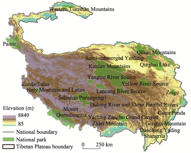
Figure 1 Location of the Tibetan Plateau National Park Cluster’s parks and reservesNote: This map is based on a map (GS (2019) 1838) downloaded from the website of the National Administration of Surveying, Mapping and Geoinformation of China. The base map has not been modified |
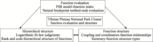
Figure 2 Logic diagram of the methods used in this study |
Table 1 System for evaluating the multiple functions of national parks |
| Function | Criterion | Indicator | Indicator analysis and nature of influence | Weight | |
|---|---|---|---|---|---|
| Ecological protection | Pressure | P1 | Human footprint | Degree of disturbance of human activities on the ecosystem (-) | 0.0703 |
| State | P2 | Ecological representation | Level and number of state-protected species (+) | 0.0342 | |
| State | P3 | Normalized difference vegetation index | Vegetation coverage and growth (+) | 0.0495 | |
| Response | P4 | Ecological elasticity | Ability of ecosystem to resist pressure and disturbance (+) | 0.0364 | |
| Response | P5 | Awareness and intensity of ecological protection | Communities and managers attach importance to ecological protection (+) | 0.0221 | |
| Scientific research | Pressure | R1 | Research infrastructure | Monitoring stations and other scientific research infrastructure (+) | 0.0578 |
| State | R2 | Research value | Citation frequency of relevant studies (+) | 0.0452 | |
| Response | R3 | Research funding | Funding for relevant research (+) | 0.0453 | |
| Education | Pressure | E1 | Education facilities and services | Signs, explanations and other educational services and facilities (+) | 0.0382 |
| State | E2 | Landscape educational value | Natural science and social cultural knowledge contained in the landscape (+) | 0.0565 | |
| Response | R3 | No. of educational venues | Educational venues/total population (+) | 0.0446 | |
| Recreation | Pressure | T1 | Traffic accessibility | Transport mileage/area (+) | 0.0481 |
| Pressure | T2 | Recreational environment suitability | Regional average elevation (-) | 0.0459 | |
| State | T3 | Tourist density | Tourists/area (+) | 0.0588 | |
| State | T4 | Tourism economic density | Tourism income/area (+) | 0.0537 | |
| Response | T5 | Tertiary industry employment percentage | Tertiary industry employees/total population (+) | 0.0440 | |
| Community development | Pressure | C1 | Urban-rural disposable income difference | Difference in disposable income of urban and rural residents (-) | 0.0474 |
| State | C2 | Per capita GRP | GRP/total population (+) | 0.0624 | |
| State | C3 | Level of urbanization | County town population/registered household population (+) | 0.0507 | |
| Response | C4 | Per capita personal savings | Personal savings/total population (+) | 0.0395 | |
| Response | C5 | Industrial structure | Value-added of primary and secondary industry/GDP (-) | 0.0494 | |
Table 2 Coupling and coordination rankings |
| Coupling | Level | Coordination | Level |
|---|---|---|---|
| (0.00, 0.30) | Weak coupling | (0.00, 0.20) | Severe imbalance |
| [0.30, 0.50) | Antagonistic (moderate) coupling | [0.20, 0.40) | Borderline imbalance |
| [0.50, 0.80) | Strong coupling | [0.40, 0.60) | Low-level coordination |
| [0.80, 1.00] | Very strong coupling | [0.60, 0.80) | Moderate coordination |
| - | - | [0.80, 1.00] | High-level coordination |
Table 3 Types of national park function structures |
| Type | Judgement criteria | Features | |
|---|---|---|---|
| Function evaluation | Coordination | ||
| Fully coordinated | 3 or more functions are optimal | ≥0.8 | Three or more functions are optimal and all functions are highly coordinated. |
| Optimally developed | 2 functions are optimal | ≥0.6 | Two functions are optimal and all functions are moderately coordinated. |
| Moderately developed | 1 function is optimal | ≥0.6 | One function is optimal and all functions are moderately coordinated. |
| Moderately underdeveloped | No functions are optimal | <0.6 | No functions are optimal or all functions are poorly coordinated. |
Figure 3 Evaluation of the multiple functions of the Tibetan Plateau National Park ClusterNote: This map is based on a map (GS (2019) 1838) downloaded from the website of the National Administration of Surveying, Mapping and Geoinformation of China. The base map has not been modified. |
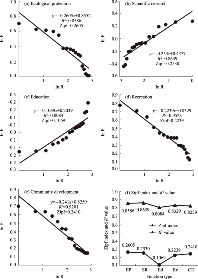
Figure 4 Tibetan Plateau National Park Cluster rank-size double logarithm fitting curve and Zipf exponential curve |
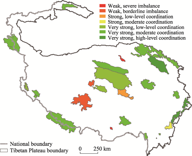
Figure 5 Coupling and coordination of the Tibetan Plateau National Park ClusterNote: This map is based on a map (GS (2019) 1838) downloaded from the website of the National Administration of Surveying, Mapping and Geoinformation of China. The base map has not been modified. |
Table 4 Function structure types of the Tibetan Plateau National Park Cluster |
| National park | Optimal function(s) | Coordination | Structure type |
|---|---|---|---|
| Pamir | Education, community development | Moderate | Optimally developed |
| Mount Qomolangma | — | Moderate | Moderately underdeveloped |
| Giant Panda | Ecological protection, scientific research, education, recreation | High-level | Fully coordinated |
| Yellow River Source | — | Moderate | Moderately underdeveloped |
| Selincuo Puruogangri | — | Borderline imbalance | Moderately underdeveloped |
| Holy Mountain and Lakes | Education | Moderate | Moderately developed |
| Yarlung Zangbo Grand Canyon | Education | Moderate | Moderately developed |
| Yangtze River Source | — | Low-level | Moderately underdeveloped |
| Daocheng Yading | Recreation | Moderate | Moderately developed |
| Dulong River and Three Parallel Rivers | — | Moderate | Moderately underdeveloped |
| Gongga Mountain | Ecological protection, recreation, community development | Moderate | Optimally developed |
| Qinghai Lake | Ecological protection, scientific research, education, community development | High-level | Fully coordinated |
| Kunlun Mountains | Community development | Moderate | Moderately developed |
| Lancang River Source | Scientific research | Low-level | Moderately underdeveloped |
| Qilian Mountains | Scientific research, education | Moderate | Optimally developed |
| Zoige | Ecological protection, scientific research | Moderate | Optimally developed |
| Semi-submerged Yardang | Community development | Severe imbalance | Moderately underdeveloped |
| Western Tianshan Mountains | Ecological protection | Moderate | Moderately developed |
| Shangrila | Ecological protection, education, recreation, community development | High-level | Fully coordinated |
| Zanda Tulin | Community development | Low-level | Moderately underdeveloped |
| Zhari Mountain | Education | Severe imbalance | Moderately underdeveloped |
Figure 6 Function structures of the Tibetan Plateau National Park ClusterNote: This map is based on a map (GS (2019) 1838) downloaded from the website of the National Administration of Surveying, Mapping and Geoinformation of China. The base map has not been modified. |
Table 5 Correspondence between the Tibetan Plateau National Park Cluster and natural ecological zones |
| Ecological zone | Code | National park (function structure; optimal function(s)) |
|---|---|---|
| Tianshan Mountains desert, grassland, coniferous forest | IID5 | Western Tianshan Mountains (moderate development; ecological protection) |
| Southern flank of Eastern Himalayas-mountain monsoon forest/evergreen broadleaf forest | VA6 | Yarlung Zangbo Grand Canyon (moderate development; education) |
| Golog-Nagqu plateau’s alpine shrub and meadows | HIB1 | Zoige (optimal development; ecological protection and scientific research), Lancang River Source (moderate underdevelopment; scientific research) |
| Southern Qinghai Plateau wide valley alpine meadow steppe | HIC1 | Yangtse River Source (moderate underdevelopment), Yellow River Source (moderate underdevelopment) |
| Qiantang Plateau lake basin alpine steppe | HIC2 | Selincuo Puruogangri (moderate underdevelopment), Holy Mountain and Lakes (moderate development; education) |
| Kunlun Mountains plateau and alpine desert | HID1 | Pamir (optimal development; education and community development) |
| Coniferous forest in the deep valleys of the eastern mountains of Sichuan and Tibet | HIIA/B1 | Dulong River and Three Parallel Rivers (moderate underdevelopment), Gongga Mountain (optimal development; ecological protection, recreation, community development), Shangrila (fully coordinated; ecological protection, education, recreation, community development), Daocheng Yading (moderate development; recreation), Giant Panda (fully coordinated; ecological protection, research, education, recreation) |
| Qilian Mountains basin eastern Qinghai-coniferous forest/steppe | HIIC1 | Qilian Mountains (optimal development; research, education), Qinghai Lake (fully coordinated; ecological protection, research, education, community development) |
| Southern Tibet high valley shrubland and steppe | HIIC2 | Mount Qomolangma (moderate underdevelopment), Zhari Mountain (moderate underdevelopment; education) |
| Qaidam Basin | HIID1 | Semi-submerged Yardang (moderate underdevelopment; community development) |
| Northern flank of Kunlun Mountains-desert | HIID2 | Kunlun Mountains (moderate development; community development) |
| Ngari mountain desert | HIID3 | Zanda Tulin (moderate underdevelopment; community development) |
| [1] |
|
| [2] |
|
| [3] |
|
| [4] |
|
| [5] |
|
| [6] |
|
| [7] |
|
| [8] |
|
| [9] |
|
| [10] |
|
| [11] |
|
| [12] |
|
| [13] |
|
| [14] |
|
| [15] |
|
| [16] |
|
| [17] |
|
| [18] |
|
| [19] |
|
| [20] |
|
| [21] |
|
| [22] |
|
| [23] |
|
| [24] |
|
| [25] |
|
| [26] |
|
| [27] |
|
| [28] |
|
| [29] |
|
| [30] |
|
| [31] |
|
| [32] |
|
| [33] |
|
| [34] |
|
| [35] |
|
| [36] |
|
| [37] |
|
| [38] |
|
| [39] |
|
| [40] |
|
| [41] |
|
| [42] |
|
| [43] |
|
| [44] |
|
| [45] |
|
| [46] |
|
| [47] |
|
| [48] |
|
| [49] |
|
| [50] |
|
| [51] |
|
| [52] |
|
| [53] |
|
| [54] |
|
| [55] |
|
| [56] |
|
| [57] |
|
| [58] |
|
| [59] |
|
| [60] |
|
/
| 〈 |
|
〉 |

