
Journal of Geographical Sciences >
Spatiotemporal distribution of sea-island prehistoric dune sites, Holocene sea levels, and aeolian sand activities in Fujian Province, China
|
Jin Jianhui (1981-), Associate Professor, specialized in aeolian geomorphology and luminescence chronology. E-mail: geojjh@fjnu.edu.cn |
Received date: 2021-09-09
Accepted date: 2021-12-23
Online published: 2022-08-25
Supported by
National Natural Science Foundation of China(41301012)
National Natural Science Foundation of China(41771020)
Natural Science Foundation of Fujian Province(2020J01185)
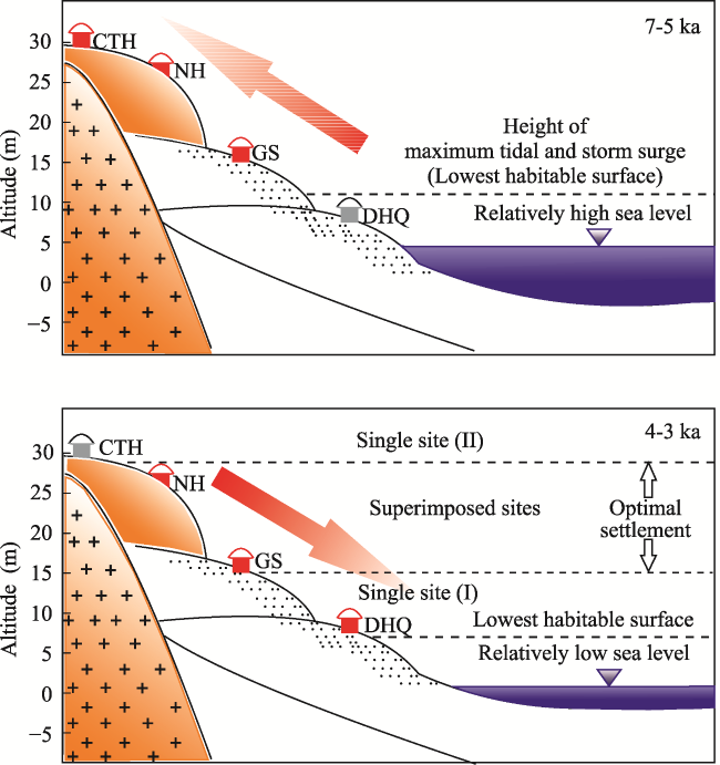
The lower reaches of the Minjiang River and its adjacent areas were among the most active prehistoric archaeological areas in Fujian Province. The accumulation types of Neolithic archaeological strata are roughly divided into dune sites and dune/shell mound sites. The sites can also be roughly divided into estuarine, coastal, and sea-island sites based on their geomorphic features. The cultural development of these prehistoric sites is of great significance for understanding the migration and spread of Austronesian civilization. Based on luminescence dating of typical Neolithic sites on Haitan Island, their quartz-OSL (optically stimulated luminecesence) burial ages were determined. Synthesizing previously published results, the temporospatial distribution characteristics of the sea-island sites on Haitan Island are discussed, and the relationship between Neolithic human activities and regional geomorphic processes is analyzed. The results show that: (1) the spatial and temporal distribution of the Haitan Island Neolithic sites are closely related to small-scale geomorphic features and are controlled by mesoscale geomorphic processes. The sites were mainly distributed in the foothills of two high hills along an NNE-SSW trend. With an increase in altitude, the features were distributed as “single site (I) - superimposed site - single site (II)” and appear successively. Single type sites (I) mainly appeared at low sea level, whereas single type sites (II) mainly appeared at high sea level. Superimposed sites were not subject to sea level changes. The relative elevation of the superimposed sites in the study area indicates the optimal residential area for human activities in the region. The single site with an elevation lower than the optimal residential area was mainly restricted by the lowest residential area, whereas the single site at a higher elevation than the optimal residential area was mainly affected by livelihood patterns. (2) High sea level caused by the “backwater effect” in low latitude areas in the southern hemisphere, and coastal aeolian sand activity influenced by sea level fluctuations in the middle Holocene correspond well with human activities recorded in the cultural stratigraphy of sea-island type sites. The altitude of coastal aeolian sand accumulation can be used as an indirect index to estimate the age of coastal dunes.
JIN Jianhui , LING Zhiyong , LI Zhizhong , ZUO Xinxin , FAN Xuechun , HUANG Yunming , WANG Xiaoyang , WEI Changfu , REN Yongqing , QIU Junjie . Spatiotemporal distribution of sea-island prehistoric dune sites, Holocene sea levels, and aeolian sand activities in Fujian Province, China[J]. Journal of Geographical Sciences, 2022 , 32(6) : 1157 -1176 . DOI: 10.1007/s11442-022-1990-9
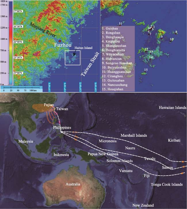
Figure 1 The location and the distribution of prehistoric sites and Austronesian migration routes |
Table 1 Overview of Neolithic-Bronze age sites in Haitan Island and its adjacent islands |
| No. | Name of site | Types | Location | Elevation (m) | Area (m2) | Remains | General characteristics | |||
|---|---|---|---|---|---|---|---|---|---|---|
| 1 | Guishan | Settlement | 25°37°53"N, 119°45°32"E | 16 | 1600 | Pottery, shell | It can be divided into 4 layers, from bottom to top, red brown old red sand, red brown medium sand (containing a small amount of pottery), gray brown medium and fine sand (containing a large number of pottery and stone tools), cultivated soil layer. | |||
| 2 | Rongshan | Settlement | 25°37°32"N, 119°45°06"E | 25 | 800 | Pottery | It can be divided into 4 layers, from bottom to top: red-brown old red sand layer (20 cm), light brown medium coarse sand layer (15 cm), yellow-brown medium coarse sand layer (40 cm) and light gray medium sand layer (20 cm). | |||
| 3 | Donghuaqiu | Settlement | 25°37°59"N, 119°45°45"E | 8 | 1500 | Pottery | It can be divided into 5 layers, which are yellow and orange medium sand, gray and brown clay sand, gray and yellow medium sand, gray and brown medium sand (including a small amount of sand-embedded ceramics and gray hard pottery) and light gray medium and fine sand from bottom to top. | |||
| 4 | Keqiutou | Settlement | 25°37°50"N, 119°45°40"E | 10 | 4000 | Pottery, shell | It can be divided into 7 layers, including 7-5 layers of red-brown old red sand layer (70-90 cm), yellow-orange medium sand layer (25 cm), yellow loose medium sand layer (15-20 cm), light yellow medium and fine sand layer (18-20 cm), gray yellow medium and fine sand layer (10-15 cm) from bottom to top. | |||
| 5 | Shengloushan | Settlement | 25°36°50"N, 119°44°29"E | 19 | 10000 | Pottery | It can be divided into 6 layers, from bottom to top, reddish-brown old red sand, reddish-brown old red sand containing a small amount of embedded pottery (5-28 cm), reddish-brown medium coarse sand containing a large amount of pottery (12-26 cm), gray-brown medium sand (12-21 cm), gray-yellow medium sand (18-26 cm), cultivation layer (24-30 cm). | |||
| 6 | Dongbiansha | Settlement | 25°36°59"N, 119°44°11"E | 14 | 10000 | Pottery | It can be divided into 6 layers. From bottom to top, the layers are reddish-brown medium sand, dark brown fine sand (including a small amount of rope grain, cloud thunder grain sand and clay clay), yellow-brown medium sand, dark brown fine sand, yellow-orange medium sand (including a small amount of porcelain), brown medium sand and cultivation layer. | |||
| No. | Name of site | Types | Location | Elevation (m) | Area (m2) | Remains | General characteristics | |||
| 7 | Wayaoshan | Settlement | 25°35°41"N, 119°44°15"E | 13 | 1500 | Pottery | It can be divided into 4 layers, from bottom to top, the yellow medium coarse sand layer, gray brown medium sand layer (20-30 cm) containing sand red pottery and yellow pottery, a small amount of shell and terra-cotta soil, light gray medium sand layer (50cm) and cultivation layer (10-20 cm). | |||
| 8 | Hubiancun | Settlement | 25°35°27"N, 119°53°31"E | 5 | 2500 | Pottery | A small amount of sand-gray and gray printed hard pottery was collected. | |||
| 9 | Songcuo Houshan | Settlement | 25°33°38"N, 119°47°43"E | 40 | 4000 | Pottery | It can be divided into 4 layers, from bottom to top, the reddish brown sandy clay, the light gray sandy clay containing pottery (18-23 cm), with carved patterns, the light gray sandy clay containing a small amount of terrazzo (6-14 cm), and the top layer of gray sandy clay (10-18 cm). | |||
| 10 | Baiyunshan | Settlement | 25°33°15"N, 119°51°54"E | 8 | 3000 | Pottery, stone tools | A small amount of stone tools and pottery were collected. | |||
| 11 | Huangguan- shan | Unknown | 25°34°24"N, 119°34°15"E | 15 | 1000 | Stone tools, pottery | A small amount of stone tools and pottery were collected. | |||
| 12 | Citanghou | Settlement | 25°28°50"N, 119°43°53"E | 30 | 600 | Pottery, shell | It can be divided into 5 layers. From bottom to top, the layers are gray black clay, yellowish brown fine sand, gray black medium sand (including terra-cotta soil, sand embedded red pottery), gray yellow medium sand, gray brown medium sand. | |||
| 13 | Guitoushan | Settlement | 25°28°13"N, 119°45°28"E | 10 | Unknown | Stone tools, pottery | No cultural layers. | |||
| 14 | Nancuochang | Settlement | 25°26°02"N, 119°44°21"E | 10 | 1500 | Pottery, shell | It can be divided into 5 layers, from bottom to top, they are reddish brown medium coarse sand, silty sand, black brown shell layer with a little corded sand red pottery, reddish brown medium sand and cultivation layer. | |||
| 15 | Houqishan | Unknown | 25°22°35"N, 119°43°09"E | 25 | 800 | Stone tools, pottery | It can be divided into 3 layers, from the bottom to the top, they are red-brown old red sand (containing a small amount of terra-cotta and sand-embedded pottery), red-brown medium sand (including printed hard pottery), and red-brown clay sand. | |||
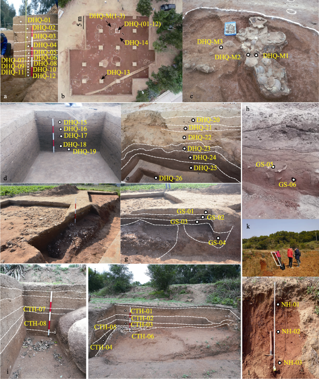
Figure 2 The sampling locations and sedimentary structure of typical Neolithic sites in Haitan Island and its adjacent islands (a-e. Donghuaqiu Site; f-h. Guishan Site; i-j. Chitanghou Site; k-l. Houqishan Site) |
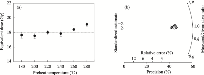
Figure 3 Results of preheat plateau test and dose recovery test for sample DHQ-09 |
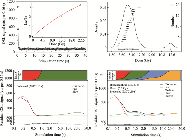
Figure 4 The dose response curve obtained using the SAR protocol for sample DHQ-09 and CW-OSL signals from natural quartz for the corresponding sample |
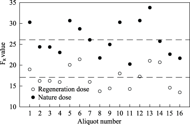
Figure 5 OSL fast ratios of sample DHQ-09 measured from the natural OSL signals and regenerative dose OSL signals |
Table 2 The optically stimulated Luminescence dating results of sediment of typical Neolithic sites |
| Lab. No. | name | U (µg/g) | Th (µg/g) | K (%) | Moisture content (%) | Aliquots | Dose rate (Gy/ka) | De (Gy) | Age model | Age (ka) |
|---|---|---|---|---|---|---|---|---|---|---|
| 2018029 | DHQ-01 | 1.61±0.08 | 5.17±0.26 | 0.91±0.05 | 10±5 | 9/20 | 1.67±0.09 | 0.23±0.12 | CAM | 0.14±0.07 |
| 2018030 | DHQ-02 | 1.37±0.07 | 5.25±0.26 | 1.00±0.05 | 10±5 | 17/20 | 1.71±0.09 | 0.13±0.06 | CAM | 0.08±0.04 |
| 2018031 | DHQ-03 | 1.19±0.06 | 4.84±0.24 | 1.08±0.05 | 10±5 | 7/20 | 1.70±0.09 | 0.68±0.20 | CAM | 0.40±0.12 |
| 2018032 | DHQ-04 | 1.52±0.08 | 9.39±0.47 | 0.65±0.03 | 10±5 | 6/20 | 1.68±0.08 | 0.51±0.02 | CAM | 0.31±0.02 |
| 2018033 | DHQ-05 | 1.36±0.07 | 6.19±0.31 | 0.92±0.05 | 10±5 | 8/20 | 1.69±0.09 | 0.82±0.10 | CAM | 0.49±0.07 |
| 2018034 | DHQ-06 | 1.93±0.10 | 9.36±0.47 | 0.83±0.04 | 10±5 | 16/16 | 1.93±0.10 | 3.49±0.30 | CAM | 1.82±0.18 |
| 2018035 | DHQ-07 | 1.61±0.08 | 8.11±0.41 | 0.77±0.04 | 10±5 | 36/36 | 1.74±0.09 | 5.06±1.94 | CAM | 2.96±1.14 |
| 2018036 | DHQ-08 | 1.79±0.09 | 8.11±0.41 | 0.97±0.05 | 10±5 | 20/25 | 1.95±0.10 | 4.54±1.13 | CAM | 2.36±0.60 |
| 2018037 | DHQ-09 | 1.87±0.09 | 9.02±0.45 | 0.91±0.05 | 10±5 | 18/20 | 1.97±0.10 | 5.12±0.37 | CAM | 2.63±0.23 |
| 2018038 | DHQ-11 | 1.98±0.10 | 9.84±0.49 | 0.85±0.04 | 10±5 | 18/25 | 2.00±0.10 | 11.84±1.86 | CAM | 6.01±0.99 |
| 2018039 | DHQ-10 | 2.09±0.10 | 10.58±0.53 | 0.74±0.04 | 10±5 | 21/25 | 1.97±0.10 | 7.13±0.71 | CAM | 3.67±0.44 |
| 2018040 | DHQ-12 | 2.12±0.11 | 10.08±0.50 | 0.79±0.04 | 10±5 | 23/25 | 2.00±0.10 | 12.05±1.74 | CAM | 6.14±0.97 |
| 2018041 | DHQ-13 | 2.09±0.10 | 9.72±0.49 | 1.08±0.05 | 10±5 | 19/25 | 2.21±0.11 | 11.58±1.87 | CAM | 5.29±0.89 |
| 2018042 | DHQ-14 | 1.41±0.07 | 5.82±0.29 | 0.83±0.04 | 10±5 | 15/25 | 1.59±0.08 | 10.38±0.87 | CAM | 6.59±0.65 |
| 2017007 | DHQ-15 | 1.49±0.07 | 5.85±0.20 | 1.44±0.05 | 10±5 | 15/32 | 2.24±0.12 | 0.10±0.05 | CAM | 0.05±0.02 |
| 2017008 | DHQ-16 | 1.18±0.06 | 5.45±0.19 | 1.42±0.05 | 10±5 | 12/32 | 2.11±0.12 | 0.47±0.02 | CAM | 0.23±0.02 |
| 2017009 | DHQ-17 | 1.45±0.07 | 8.72±0.27 | 1.44±0.05 | 10±5 | 19/30 | 2.40±0.13 | 0.70±0.03 | CAM | 0.30±0.02 |
| 2017010 | DHQ-18 | 1.08±0.06 | 5.13±0.18 | 1.33±0.05 | 10±5 | 30/30 | 1.92±0.11 | 1.11±0.04 | CAM | 0.58±0.04 |
| 2017011 | DHQ-19 | 1.41±0.07 | 5.69±0.20 | 1.29±0.05 | 10±5 | 29/30 | 2.01±0.11 | 4.90±0.30 | CAM | 2.48±0.20 |
| 2016100 | DHQ-20 | 1.08±0.06 | 7.10±0.23 | 1.36±0.05 | 10±5 | 35/40 | 2.02±0.11 | 3.29±0.17 | CAM | 1.60±0.12 |
| 2017001 | DHQ-21 | 0.94±0.05 | 7.67±0.25 | 1.14±0.05 | 10±5 | 40/40 | 1.84±0.10 | 2.19±0.13 | CAM | 1.18±0.09 |
| 2017002 | DHQ-22 | 1.09±0.06 | 6.19±0.21 | 1.14±0.05 | 10±5 | 40/40 | 1.79±0.09 | 2.04±0.26 | CAM | 1.13±0.16 |
| 2017003 | DHQ-23 | 0.97±0.05 | 5.23±0.18 | 1.33±0.05 | 10±5 | 70/70 | 1.91±0.11 | 2.11±0.13 | CAM | 1.12±0.10 |
| 2017004 | DHQ-24 | 0.66±0.04 | 2.75±0.12 | 0.93±0.04 | 10±5 | 26/32 | 1.38±0.08 | 6.60±0.50 | CAM | 5.06±0.48 |
| 2017005 | DHQ-25 | 1.23±0.06 | 7.12±0.23 | 1.2±0.05 | 10±5 | 28/32 | 1.98±0.10 | 13.77±1.51 | CAM | 7.08±0.86 |
| 2017006 | DHQ-26 | 1.04±0.06 | 6.21±0.21 | 1.34±0.05 | 10±5 | 30/32 | 2.12±0.12 | 0.72±0.11 | CAM | 0.37±0.06 |
| 2020022 | DHQ-M1 | 1.99±0.10 | 10.6±0.53 | 1.21±0.06 | 10±5 | 21/32 | 2.34±0.12 | 9.56±1.20 | MAM | 4.09±0.56 |
| 2020023 | DHQ-M2 | 2.04±0.10 | 11.3±0.57 | 1.34±0.07 | 10±5 | 25/32 | 2.51±0.13 | 11.03±1.51 | MAM | 4.39±0.65 |
| 2020024 | DHQ-M3 | 1.97±0.10 | 11.3±0.57 | 1.19±0.06 | 10±5 | 26/32 | 2.36±0.12 | 6.71±0.88 | MAM | 2.84±0.4 |
| 2017012 | GS-04 | 1.40±0.07 | 10.90±0.32 | 1.11±0.04 | 10±5 | 20/20 | 2.06±0.10 | 22.50±0.68 | CAM | 10.51±0.6 |
| 2017013 | GS-03 | 1.44±0.07 | 10.30±0.30 | 1.24±0.05 | 10±5 | 19/20 | 2.14±0.11 | 11.48±0.67 | CAM | 5.15±0.4 |
| 2017014 | GS-02 | 1.71±0.08 | 10.30±0.30 | 1.18±0.05 | 10±5 | 20/20 | 2.21±0.11 | 7.25±0.27 | CAM | 3.25±0.25 |
| 2017015 | GS-01 | 2.45±0.10 | 15.60±0.42 | 1.66±0.06 | 10±5 | 13/20 | 3.35±0.17 | 0.11±0.02 | CAM | 0.03±0.01 |
| 2020020 | GS-05 | 0.97±0.05 | 10.30±0.30 | 1.21±0.06 | 10±5 | 15/16 | 2.10±0.11 | 15.44±1.52 | MAM | 7.36±0.82 |
| 2020021 | GS-06 | 1.91±0.10 | 15.30±0.42 | 1.13±0.06 | 10±5 | 22/32 | 2.55±0.13 | 15.05±2.25 | MAM | 5.90±0.93 |
| 2020025 | CTH-01 | 1.28±0.06 | 8.36±0.42 | 2.95±0.15 | 10±5 | 12/12 | 3.58±0.23 | 0.24±0.06 | CAM | 0.07±0.02 |
| 2020026 | CTH-02 | 1.57±008 | 9.92±0.50 | 2.54±0.13 | 10±5 | 32/32 | 3.38±0.21 | 1.55±0.17 | CAM | 0.46±0.06 |
| 2020027 | CTH-03 | 1.53±0.08 | 10.6±0.53 | 2.36±0.12 | 10±5 | 10/32 | 3.26±0.20 | 2.92±0.51 | MAM | 0.90±0/17 |
| 2020028 | CTH-04 | 1.66±0.08 | 13.2±0.66 | 1.89±0.09 | 10±5 | 14/32 | 3.03±0.17 | 7.43±0.40 | CAM | 2.45±0.19 |
| 2020029 | CTH-05 | 1.79±0.09 | 14.9±0.75 | 1.79±0.09 | 10±5 | 14/16 | 3.08±0.17 | 18.58±1.45 | CAM | 6.03±0.58 |
| 2020030 | CTH-06 | 1.38±0.07 | 11.2±0.56 | 1.84±0.09 | 10±5 | 21/22 | 2.80±0.16 | 15.23±0.45 | CAM | 5.44±0.35 |
| 2020031 | CTH-07 | 1.69±0.08 | 14.7±0.74 | 2.50±0.13 | 10±5 | 4/22 | 3.67±0.27 | 5.16±1.15 | CAM | 1.40±0.33 |
| 2020032 | CTH-08 | 1.87±0.09 | 14.2±0.71 | 2.65±0.13 | 10±5 | 20/20 | 3.81±0.28 | 9.82±0.35 | CAM | 2.57±0.21 |
| 2017029 | NH-01 | 2.00±0.09 | 7.97±0.26 | 1.11±0.04 | 10±5 | 10/15 | 1.99±0.11 | 1.81±0.04 | CAM | 0.87±0.05 |
| 2017030 | NH-02 | 2.23±0.09 | 8.27±0.26 | 1.20±0.04 | 10±5 | 15/15 | 2.11±0.11 | 6.19±0.69 | CAM | 2.77±0.36 |
| 2017031 | NH-03 | 1.40±0.07 | 6.95±0.23 | 1.29±0.05 | 10±5 | 15/15 | 2.05±0.11 | 9.66±0.51 | CAM | 4.71±0.35 |
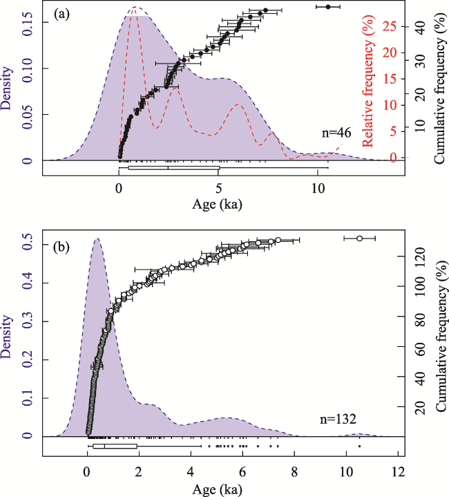
Figure 6 Comparison of the age of typical dune sites on Haitan Island and the Holocene aeolian sand along the coast of Fujian Province |
Figure 7 Schematic diagram of the coupling relationship between Haitan Island settlement site distribution and sea level fluctuation |
| [1] |
|
| [2] |
|
| [3] |
|
| [4] |
|
| [5] |
|
| [6] |
|
| [7] |
|
| [8] |
|
| [9] |
|
| [10] |
|
| [11] |
|
| [12] |
|
| [13] |
|
| [14] |
|
| [15] |
|
| [16] |
Fujian Tanshishan Museum (FTM), 2018. Archaeological Investigation and Research of Prehistoric Sites in the Lower Reaches of Minjiang River. Beijing: Science Press. (in Chinese)
|
| [17] |
|
| [18] |
|
| [19] |
|
| [20] |
|
| [21] |
|
| [22] |
|
| [23] |
|
| [24] |
|
| [25] |
|
| [26] |
|
| [27] |
|
| [28] |
|
| [29] |
|
| [30] |
|
| [31] |
|
| [32] |
|
| [33] |
|
| [34] |
|
| [35] |
|
| [36] |
|
| [37] |
|
| [38] |
|
| [39] |
|
| [40] |
|
| [41] |
|
| [42] |
|
| [43] |
|
| [44] |
|
| [45] |
|
| [46] |
|
| [47] |
|
| [48] |
|
| [49] |
|
| [50] |
|
| [51] |
|
| [52] |
|
| [53] |
|
| [54] |
|
| [55] |
|
| [56] |
|
| [57] |
|
| [58] |
|
| [59] |
|
| [60] |
|
/
| 〈 |
|
〉 |