Research article

Scientific attributes and expression methods of geographical boundary

  • TANG Guoan , 1, 2, 3 ,
  • LI Jilong , 1, 2, 3, 4, * ,
  • XIONG Liyang 1, 2, 3 ,
  • NA Jiaming 1, 2, 3
Expand
  • 1.Key Laboratory of Virtual Geographic Environment, Ministry of Education, Nanjing Normal University, Nanjing 210023, China
  • 2.School of Geography, Nanjing Normal University, Nanjing 210023, China
  • 3.Jiangsu Center for Collaborative Innovation in Geographical Information Resource Development and Application, Nanjing 210023, China
  • 4.School of Geography and Planning, Ningxia University, Yinchuan 750021, China
* Li Jilong, Lecturer, specialized in digital terrain analysis. E-mail:

Tang Guoan, Professor, specialized in geographical information science. E-mail:

Received date: 2022-02-08

  Accepted date: 2022-03-20

  Online published: 2022-08-25

Supported by

National Natural Science Foundation of China(41930102)

Abstract

A scientific delineation of geographical boundaries reflects the cognitive level of scientific abstraction and systematic analysis of the spatial variation of geographical objects and is a basic scientific issue of geography. From the perspective of earth system science, this study first explicates the core issues (e.g., basic concepts, scientific contents, and basic properties) of geographical boundaries. Based on the principles of scientificity and systematicness, we then classify geographical boundaries in terms of intrinsic mechanisms, extrinsic appearance and scientific attributes. Furthermore, this paper analyzes the mathematical connotation and representation methods of geographical boundaries, discusses the characteristics of and differences between traditional and modern methods for geographical boundary delineation. Finally, we present a framework for a “geographical boundary model” with an integration of qualitative, quantitative, and positioning methods. Focusing on geographical boundary (a basic theoretical problem in geography), this study engaged in concept definition and method analysis, with the findings enriching the theory and methodology of geographical information science.

Cite this article

TANG Guoan , LI Jilong , XIONG Liyang , NA Jiaming . Scientific attributes and expression methods of geographical boundary[J]. Journal of Geographical Sciences, 2022 , 32(6) : 1119 -1135 . DOI: 10.1007/s11442-022-1988-3

1 Concept of the geographical boundary

The spatial spread of geographical objects has both similarities and differences in their properties. There are not only relatively clear and definite geographical boundaries (e.g., a coastline dividing the ground into land and sea, a border line dividing a territory into two different countries, and a ridge line dividing the two sides of a mountain into different watersheds), but also relatively fuzzy and comprehensive geographical boundaries (e.g., the “Hu Line” that divides China into two different population-density zones on its east and west sides and the demarcation line between a red and yellow soil). Systematic classification and spatial positioning of geographical boundaries are a key issue in both single-factor geographical studies and systematic comprehensive geographical studies. Unclear delineation of geographical boundaries not only adversely affect geographical cognition but also fail to fully reveal and represent the laws of geospatial differentiation, thus failing to reflect the interrelationship between geographical boundaries, patterns, and regularities. Therefore, a correct understanding of the scientific connotation, external manifestation, and clear definition of geographical boundaries is a fundamental theoretical issue in geography.
The general concept of “boundary” is interpreted in The Contemporary Chinese Dictionary as “the demarcation line between different areas” (Dictionary Editorial Office, 2016) and in Webster’s English Dictionary as “something that indicates or fixes a limit or extent” (Staff, 2003). In fact, the definition or representation of “boundary” varies across different disciplinary fields. In topology, a boundary refers to the interior of a closure minus a subset of topological space (Mendelson, 1990), whereas in thermodynamics, a boundary refers to an actual or hypothetical two-dimensional closed surface that surrounds or demarcates the spatial region occupied by a thermodynamic system and through which matter, heat, or work are allowed to flow (Perrot, 1998).
The study scale of geography is the surface-layer space of the earth, on which scale geographical boundaries are studied to solve various geography problems. Geographical boundaries have both basic geographical properties and certain special properties relative to other types of boundaries. The Dictionary of Modern Geography defines a geographical boundary as “a line or belt that distinguishes adjacent geographical units and which is usually positioned in the belt with the greatest gradient of variation in geographical elements or comprehensive geographical features” (Zuo, 1990). The definition highlights the following points: 1) objects distinguished by a geographical boundary are adjacent and distinct geographical units; 2) the properties of geographical objects differ significantly across different geographical units; 3) the “greatest gradient of variation” includes the relative change in geographical phenomena; however, the definition of geographical boundaries according to the change in gradient alone lacks the structural basis of geographical boundaries (Zhou, 1992); and 4) boundaries are usually manifested as abruptly-changing lines or gradually-changing belts that reflect the transitiveness and fuzziness of geographical boundaries. Additionally, Chinese researchers argue that a geographical boundary is a continuum of points from quantitative change to qualitative change, and on two sides of the boundary there exist zones with alternating similarities and differences (Zheng et al., 2005, 2008). The National Geographical Society defined geographical boundaries as lines that separate different regions of the earth and classified them into physical boundaries, political boundaries, and other boundaries. Moreover, certain researchers noted that the definition and concept of geographical boundaries should consider two major types of geographical boundaries: fixed natural boundaries (e.g., coastlines, rivers, and mountains); and artificially defined, large-range boundaries (e.g., air-pollution boundaries and urban boundaries) (Haining, 1993). In summary, a geographical boundary can be explicitly defined as a line or transitional zone that possesses a number of different transitional properties (e.g., dominant abrupt change and fuzzy gradual change) that distinguish various geographical units.
However, the actual definition of geographical boundaries faces many theoretical and methodological issues that are yet to be clarified. First, geographical boundaries are a mapping of certain geographical phenomena or processes in terms of spatial similarities and differences. Regardless of which perspective the concept of “geographical boundary” is discussed, we must fully consider scale, matching pattern, and correction of geographical units’ issues in this mapping relationship (Burt et al., 2009).
Second, geographical boundaries are a way to depict the world, and their objective existence is inevitable. However, the results of geographical boundary delineation can vary according to the methods used, thus resulting in considerable subjectivity in the studies of geographical boundaries. Objective and subjective delineation methods are interdependent. Specifically, objective delineation methods are mostly based on subjective cognition of geographical phenomena or processes, whereas subjective methods must rely on objective properties of geographical boundaries for highly-targeted definition of geographical boundaries. Therefore, how to combine subjective and objective delineation methods and effectively interrelate qualitative and quantitative delineation methods is an important orientation of current studies. The development of geographical information science (GIS) provides an effective solution to this problem.
GIS is the third-generation language of geography (Chen, 1983) and digitally represents the extremely complex real world in an abstract way (Jacquez et al., 2000; Hu et al., 2012), with the development of GIS-related theories and methods providing a qualitative/quantitative/positioning-integrated approach and more diverse representation methods for the studies of geographical boundaries. One of the core features of GIS is the modeling language, which can transform the traditional studies of geographical boundaries into quantitative model-based studies, thus developing a discretized and modeled concept of geographical boundaries in the context of GIS (Xiao and Li, 1998; Cao et al., 2001).

2 Scientific connotation of geographical boundary

Geography is a discipline that studies spatial-differentiation regularities, temporal-evolution processes, and the regional characteristics of geographical elements and complexes (Fu, 2017). Defining a geographical boundary involves a high degree of abstraction and condensation of spatial-differentiation regularities, the temporal-evolution process, and regional characteristics of the earth surface system and also represents the most basic problem in geography. Geographical boundaries are an extremely complex, abstract, and comprehensive theoretical problem (Xiong et al., 2021) that involves deep scientific connotations.
First, geographical boundaries can fully reveal the spatiotemporal homogeneity, heterogeneity, and similarity characteristics of geography. Tobler (1970) argued that everything is related to everything else, but near things are more related than distant things (this is referred to as the First Law of Geography). Goodchild (2004) subsequently proposed the Second Law of Geography, stating that geographical variables exhibit uncontrolled variance (i.e., spatial heterogeneity). For example, landscape heterogeneity refers to the degree of variation in a landscape or its attributes (Qiu et al., 2000). As a complex of natural and human landscapes, geographical systems are no exception. Heterogeneity is an essential property of geographical systems, and the studies of landscapes and heterogeneity are closely related (Risser, 1987). Therefore, spatiotemporal heterogeneity is an important objective feature in geographical phenomena, and this feature is most directly manifested in geographical boundaries. Based on geographical environments, Zhu et al. (2020) proposed the Third Law of Geography, stating that the more similar of geographical configuration, the more similar the attribute values and the processes. Compared with the First and Second Laws of Geography, the Third Law of Geography has a certain degree of independence and places more emphasis on the interaction of multiple elements in geographical phenomena (Zhu et al., 2018). This specifically addresses the interrelationship or interaction across the combination of target geographical elements and other geographical elements at the point of positioning (Zhu et al., 2018), which can be directly manifested by the boundaries of geographical environment bodies. In particular, interactions at points determine the complexity of geographical boundaries, which can in turn reflect the status of interactions between multiple elements in geographical phenomena.
These laws of geography describe the universal laws followed by geographical systems and are highly objective. Although none of the three laws specially refer to geographical boundaries, the provided analysis reveals that geographical boundaries exist objectively (i.e., they are a combination of homogeneity, heterogeneity, and similarity results in the complexity of geographical boundaries). Therefore, geographical boundaries are determined by a combination of spatiotemporal homogeneity, heterogeneity, and similarity of geographical environments or properties.
Second, geographical boundaries and their delineation processes are the most intuitive manifestation of the nonlinearity of geographical systems. Geographical phenomena are complex, with an integration of necessity and occasionality and bound to have certain complex and nonlinear characteristics (Ma, 2001). As exemplified by geomorphic systems, Phillips (2003) argued that such systems usually present complex and obvious randomness in spatial and temporal domains, with this randomness usually arising from the cumulative effect of a single process-response mechanism. Because nonlinear mechanisms are too numerous to be explained in terms of a single factor or a series of spatial and temporal response relationships controlled by diverse factors, thus resulting in nonlinear features (e.g., chaos, dissipation, bifurcation, and abrupt change), these jointly cause a complex relationship between inputs and outputs in geographical systems. Whether from a micro or macro perspective, geographical units in a complete geographical system inevitably depend on and interact with each other spatially, thus developing an extremely complex nonlinear developmental relationship (Zhou, 1992).
In fact, the nonlinearity of geographical systems is a complex characteristic of changes in these systems and is classifiable (Swain et al., 2016). Regions are delimited using certain indicators and methods based on an objective knowledge of the spatiotemporal differences of geographical systems. The boundary of a system does not depend on a specific objectively existent geographical entity (Wei, 1986); however, as a manifestation of the nonlinear characteristics of the earth surface system, geographical boundaries are essentially an objective reflection of geographical change in geospatial matter and energy, and this change also follows the universal law of the objective world from quantitative change to qualitative change (Tang, 1987; Schonewald, 2000). Therefore, the delineation of geographical boundaries is not only a necessary way to understand the objective world but also an important means of recognizing geographical phenomena and regularities.
Moreover, geographical boundaries are an important bridge for the self-organization process of geographical systems and also a result of the contradiction between the disorderliness and orderliness in the earth surface system. For the whole geosystem, the spatiotemporal changes of its internal geographical elements are usually nonlinear and non-stationary (Li et al., 2003; Li et al., 2019) and result in a chaotic and disorderly state of the geosystem. The geographical dissipative structure theory posits that a geographical system is an open system far from the equilibrium state, has significant self-organizational characteristics, and can develop a new stable and orderly structure under certain conditions by continuously exchanging matter and energy with the outside, thus transforming from disorderliness to orderliness (Fang, 1989). As important critical conditions in the spatial and temporal dynamic changes of geographical elements, geographical boundaries effectively partition these nonlinear and non-stationary geographical phenomena and processes. As the belt with the most frequent matter and energy exchange in geographical systems, geographical boundaries intuitively reflect changes in matter, energy, and/or information exchange and dynamic balance.
Although geographical boundaries distinguish geographical phenomena and processes, they also offer a bridge for interactions and interconnections (e.g., matter migration, energy conversion, and information transfer) between neighboring regions (Zhang and Jacob, 2013). When changes in certain phenomena or properties in a geographical system reach certain critical conditions, their geographical boundaries also face a dynamic adjustment, which maps the deep mechanism of the change process.
In summary, the delineations of entities, units, types, and regions are all closely related to geographical boundaries. The scientific connotation of geographical boundaries fully embodies the regularities of geographical spatiotemporal changes and reflects the potential pattern of natural and human changes. Geographical boundaries are of great significance in revealing the transitional and gradual characteristics of geospatial units, analyzing the complexity of geographical elements in the geographical system space, and exploring the relationship between the dynamic changes of geographical boundaries and geographical elements.

3 Basic properties of geographical boundaries

The basic properties of geographical boundaries manifest in a concentrated manner in the unity of opposites: subjectivity and objectivity, abrupt and gradual changes, and stability and change.

3.1 Dialectical unity of subjectivity and objectivity

Geographical boundaries do not exist concretely in geographical space but are abstractions based on the regularities of geospatial differentiation. Owing to the complexity and diversity of study objectives, criteria, methods, and delimitation factors, as well as the differences in cognitive perspectives between different researchers (Gao et al., 2010), there are subjective differentiated results in finalized geographical boundaries. However, from another perspective, the existence of geographical boundaries is an objective reality of spatial differences in geographical objects and phenomena. Some geographical boundaries can be easily distinguished spatiotemporally due to natural barriers or the significant characteristics of geographical objects themselves. For other geographical phenomena, geographical boundaries need to be scientifically delineated according to a certain scientific basis and by appropriate means. Regardless of the manifestation of geographical boundaries, their objectivity is independent of the differences in subjective judgments.

3.2 Dialectical unity of stability and change

The delineation of geographical boundaries must rely on a delimitation factor or indicator or a set of delimitation factors or indicators (Tang, 1987), and the matter and energy exchange between the interior and exterior of a geographical system continues to change spatiotemporally. Therefore, the delimitation indicators are apt to change within a certain spatiotemporal scale, eventually leading to the movement or structural changes of geographical boundaries. The Second Law of Geography also states that the spatial changes of geographical elements are uncontrollable (i.e., the spatial changes of geographical phenomena are inevitable), and geographical boundaries will remain dynamically stable when the external environmental variables and response variables of the geographical system reach a contradictory unity (Figure 1a).
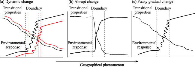
Figure 1 Types of transition properties for geographical boundaries (an amendment after Fagan et al., 2003)
The contradictory unity of stability and change in geographical boundaries also manifests in their scale-dependence. The boundary of the same geographical phenomenon or ground feature is smooth and simple when observed on a large scale but has a complex, marginal, banded structure when observed on a small scale (Long, 2013). Moreover, geographical boundaries are usually determined based on spatiotemporal data at different scales. Therefore, the indicators calculated to delineate a geographical boundary have specific scale effects (e.g., data, analysis, and representation scales) and constitute a hierarchical structure with different levels, making the boundary-delineation results scale-dependent. To completely represent the homogeneity, heterogeneity, and similarity of geographical phenomena and processes, it is of great importance to understand the multi-scale characteristics of geographical boundaries and construct multi-scale geographical boundary models.

3.3 Dialectical unity of abrupt change and gradual change

The French mathematician Rene Thom proposed catastrophe theory, positing that in all natural processes, catastrophes are fundamental, and that a gradual change comprises innumerable small catastrophes (Thom, 1977). Catastrophe theory can be transplanted to geography to construct the geographical catastrophe theory, where a number of tiny and continuous catastrophic features can produce a “cumulative effect” that causes a system catastrophe upon reaching a certain degree (in the form of a critical value or a combination of critical values) (Figure 1b).
In geography, if geographical elements have clear directions and marks (e.g., mountains, rivers), there will be obvious abrupt changes in the geographical environment. For example, the endorheic basin and exorheic basin of China are demarcated by the Yinshan-Helan Mountains-Qilian Mountains-Bayan Har Mountains-Gangdise Mountains. However, the spatial-differentiation phenomena of the earth surface system are mostly continuous and gradually transitional with few major changes; therefore, most geographical boundaries are fuzzy and usually manifest as transitional zones with a certain width and complex genesis (Figure 1c) but free of “either-or” features. Moreover, catastrophe theory posits that under strictly controlled conditions, a qualitative change is a gradual-change process if the intermediate transition state is stable (Fang, 2017). In summary, the abrupt and gradual changes in geographical boundaries are essentially a process of quantitative to qualitative changes. Both natural and human phenomena essentially comprise innumerable abrupt changes but mostly manifest in the form of gradual changes. From the GIS perspective, the contradictory unity of abrupt and gradual changes can also be analyzed and represented in light of other theories, such as set theory and fuzzy mathematics.

4 Basic types of geographical boundaries

Delineation of geographical boundaries involves characterization of geographical processes, phenomena, and objects and requires creation of an environmental-response relationship according to the inherent properties of geographical boundaries. Therefore, based on the principles of scientificity and systematicness, we classified geographical boundaries into different types in terms of internal mechanisms, external manifestation, and scientific properties (Figure 2).
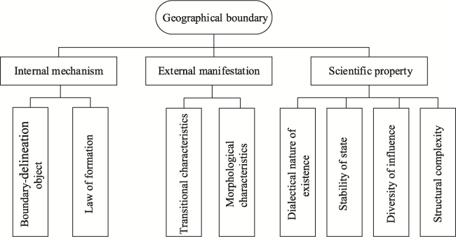
Figure 2 Schematic diagram of the basis of geographical boundaries classification
1) Internal mechanisms mainly include the delineation objects and formation law of boundaries. The delineation objects mainly include types and regions (Huang, 1965; Zheng et al., 1997; Zheng and Fu, 1999), which enable geographical boundaries to be classified into type boundaries and regional boundaries [e.g., geomorphological type boundaries and geomorphological regionalization boundaries; regionalization boundaries include geographical boundaries formed by natural factors, human factors, or a combination of the two factors (e.g., watersheds, Hu Line, and regional tourism-resource boundaries)].
2) External manifestation mainly includes transition characteristics and morphologic characteristics. In terms of the difference and complexity of geographical environments, geographical boundaries with transitional properties can be classified into geographical boundaries with dominant abrupt-change characteristics formed by natural barriers (e.g., mountains and rivers), geographical boundaries with fuzzy gradual-change characteristics of continuous and smooth transitions, and geographical boundaries with more complex alternating-transition characteristics, such as watershed boundaries, the Qinling-Huaihe line, and boundaries of soil and water loss region. Geographical boundaries show diverse morphological characteristics. In terms of the degree of regularity, geographical boundaries can be classified into regular and irregular boundaries.
3) Scientific properties include the dialectical nature of existence, stability of state, diversity of influence, and structural complexity. Regarding the dialectical nature of existence, geographical boundaries themselves are abstract and can either refer to objectively existent physical objects or be defined according to actual study objectives. Therefore, geographical boundaries can be classified into objective geographical boundaries, subject-objective integrated boundaries, such as the boundary between the Eurasian plate and African plate, and boundaries of urban development. Regarding the stability of state, none of the geographical boundaries are absolutely stable; therefore, geographical boundaries can be classified into stable geographical boundaries and dynamically changing boundaries, such as mountain boundaries and boundaries between monsoon and non-monsoon areas. Regarding the diversity of influence, the delineation of geographical boundaries is influenced by a variety of environmental elements. In terms of the quantity of and relationship between environmental elements, geographical boundaries can be classified into simple-element boundaries and complex-element boundaries, such as sea-land boundaries and comprehensive physical regionalization boundaries. Regarding structural complexity, the earth surface system has a certain hierarchical nested structure, which enables geographical boundaries to be further delineated under different scales, such as watershed boundaries of different levels.

5 Mathematic representation of and methods of delineation geographical boundaries

5.1 Mathematic representation

Geosystems are complex spatial systems, the representation of which requires scientific abstraction in a mathematical way (Chen, 2011), with the same true for representing geographical boundaries. Mathematically, geographical boundary delineation can be considered a problem of determining a range (i.e., set), with neighborhoods an underlying topology above the set. Therefore, the mathematical connotation of geographical boundaries is underpinned by sets and their neighborhood characteristics. Geographical boundaries are essentially represented by partitioning geographical processes or phenomena into a number of neighborhoods and defining arbitrarily small sets within the neighborhoods. For any neighborhood of a certain object, “a”, in geographical space, there exist both points belonging to the set of the geographical phenomenon, “A”, and points not belonging to such a set. Therefore, “a” can be considered a geographical boundary point of “A”, and the set of all boundary points of “A” is referred to as the geographical boundary of “A” (Figure 3).
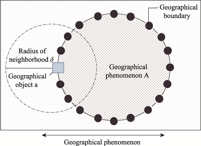
Figure 3 Schematic diagram of a simple mathematical representation of geographical boundaries
Geographical boundaries are best characterized by three transitional properties: dominant abrupt change, fuzzy gradual change, and complex alternating change. These properties are essentially a manifestation of uncertainty in the process of geographical boundary delineation. Uncertainty is an inherent property of the objective world, and the process of defining a geographical boundary is influenced by diverse factors (e.g., semantics, data, scale, model, and representation) that directly or indirectly affect the scientificity and accuracy of the boundary delineation and are also related to the decision-making and application in various fields. Fuzzy sets and rough sets can be widely applied in measuring and evaluating geographical uncertainty and can be used to represent the geographical boundaries with fuzzy-gradual changes or complex-alternating changes, thereby not only objectively evaluating the results of boundary delineation but also quantifying and controlling its uncertainty. Moreover, the diverse types of geographical boundaries can also be represented by other mathematical models or methods according to the criteria and objectives of boundary delineation. According to the most representative transitional properties of geographical boundaries (e.g., dominant-abrupt change, fuzzy-gradual change, and complex-alternating change), the mathematical connotation of geographical boundaries is modeled and represented using various theoretical methods (e.g., potential function, fuzzy set, and rough set) in this paper. The objective is to attain an in-depth understanding of the quantitative representation of geographical phenomena and processes to better facilitate the construction of geographical boundary models (Table 1).
Table 1 Mathematical model representation and comparison of geographical boundaries

5.2 Geographical boundary-delineation methods

Objective cognition and accurate delineation of geographical boundaries are important ways to reveal the spatiotemporal regularities of geographical environments. The methods for defining geographical boundaries are determined by the type of geographical boundaries and associated mathematical models, and the process of classification and mathematical representation of geographical boundaries is a process of continuous improvement in the delineation methods. Although mathematical representation provides an important theoretical basis for geographical boundary delineation, it remains a complex problem (Lin, 1954) and has always been among the most important problems in geographical studies. Additionally, geographical boundaries have unique properties. These characteristics increase the difficulties associated with the related studies; therefore, it is of great importance to adopt appropriate methods and technical means to delineate geographical boundaries according to specific goals.

5.2.1 Traditional geographical boundary-delineation methods

Traditional methods for geographical boundary delineation are usually focused on geographical regionalization, making them highly similar to geographical regionalization methods (e.g., the dominant-factor method, superposition method, geographical correlation-analysis method, and landscape-mapping method) (Zheng et al., 2008). Previous studies discussed the methods used to delineate geographical boundaries from the perspective of geographical regionalization, where geographical boundaries are the most important geographical object reflecting the differences between geospatial units. The importance of the boundaries of regionalization units is emphasized in almost all studies of geographical regionalization in both China and abroad, and geographical boundaries are a prerequisite for the existence of geographical regions (Ding, 2001).
Numerous findings concerning geographical boundary delineation in relation to geographical regionalization have been presented. Zheng et al. (2005, 2008) systematically summarized geographical regionalization in China, stressing that the determination of boundaries has always been difficult in geographical regionalization. Even in the golden period of geographical regionalization in China, the determination of many important geographical boundaries included assumptive and speculative factors due to the constraints of technical means and data, with indicator selection and construction of the indicator system yet to be further improved (Fan, 2015). Regionalization-based geographical boundary delineation requires both scientific theoretical support and technical methodological breakthroughs. Under the constraint of a priori knowledge, geographical regionalization is traditionally conducted using the expert-integration method, which is highly subjective and reliant on experiential judgment in terms of the determination of regionalization indicators and specific boundary directions, as well as insufficiently quantitative in terms of boundary delineation (Gao et al., 2010). Although these studies present a macro viewpoint, more detailed micro-level information is required (Fu, 2017). Because of the nonlinearity of geosystems and transitional properties of geographical boundaries, it is a matter of urgency to develop geographical boundary models and methods that integrate qualitative, quantitative, and positioning approaches in order to improve traditional methods for geographical boundary delineation.

5.2.2 Quantitative methods for geographical boundary delineation

With the development of geography, diverse quantitative-analysis and data-acquisition methods have emerged, and many studies have applied diverse mathematical models and representation methods to the delineation of geographical boundaries. In particular, GIS has become an indispensable technical means to quantitatively delineate geographical boundaries. GIS-related theoretical and technical methods can quantify and model spatiotemporal environmental elements and related information involved in the process of geographical boundary delineation and present the results quickly and effectively in a visual manner. However, current GIS-related theory and technology are inadequate and limited in their ability to delineate geographical boundaries. Therefore, it is important to scientifically and effectively model the wisdom and experience of geographers for applications in geographical boundary delineation. Previous studies have addressed methods capable of directly extracting geographical boundaries based on high-resolution geographical data (Li et al., 2009; Wagner and Oppelt, 2020). This method remarkably simplifies the process of delineating geographical boundaries but still has various limitations in the delineation of geographical boundaries with specific properties, such as fuzzy-gradual changes. Therefore, implementation of this method requires certain scientific theoretical support and methodological breakthroughs.
As early as 1989, Mark and Csillag (1989) proposed a ‘area-class’ model for the delineation of soil-type boundaries, with this regarded as an early study of quantitative delineation of geographical boundaries based on fuzzy mathematics. Subsequently, Geographical Objects with Indeterminate Boundaries, a collection of papers primarily edited by Burrough and Frank (1996), argued that all natural objects have indeterminate and fuzzy boundaries and systematically described the basic concept, language, and conceptual framework of geographical boundaries, thereby developing a complete research system. These studies provided an important foundation for quantitative delineation of geographical boundaries. Afterward, the fuzzy mathematics theory was widely applied for the delineation of geographical boundaries. Wang and Hall (1996) proposed a fuzzy representation method of geographical boundaries in GIS, and Jiang (1998) studied the visual representation of fuzzy boundaries of geographical objects. Additionally, Cao et al. (2001) used the fuzzy membership function to construct a geographical phenomenon model for fuzzy boundaries. Using the Bayesian areal wombling method, Lu and Carlin (2005) proposed an analysis pattern for fuzzy geographical boundaries. With the development of spatial statistical modeling theories and methods, the studies of geographical boundaries have refocused on quantitative modeling. Yan (1999a, 1999b, 2003) delineated the boundary line between the central and southern subtropical zones in Fujian Province using fuzzy comprehensive judgment, extension-engineering method, and Fisher discriminant analysis, respectively. Moreover, Li et al. (2002, 2008) used Self-organizing Feature Mapping (SOFM) model, Strategic Cyclical Scaling (SCS) paradigm and a spatial wavelet transform to identify eco-geographical boundary, respectively. Hong et al. (2008) constructed a discriminant model to divide physical geographical boundaries via modified projection pursuit method which based on the modified simplex method of optimization the projection function and direction of projection pursuit technique directly. In recent years, new methods for geographical boundary delineation have constantly emerged, including multi-faceted semantics (Gómez Álvarez and Bennett, 2017) and the Geodetector (Wang and Xu, 2017; Dong et al., 2017). Existing studies of quantitative methods for geographical boundary delineation must be conducted under the guidance of mathematical theories. Regardless of what transitional properties in the geographical boundaries, the methods can be roughly classified into the following: 1) direct extraction of boundaries from data, 2) fuzzy mathematical theory, 3) spatial statistical modeling, and 4) new delineation methods that have emerged in recent years. These methods have both advantages and disadvantages (Table 2).
Table 2 Comparison of quantitative geographical boundary delimitation methods
Method Advantage Disadvantage
Direct method This method is data-driven, follows a simple idea, and is suitable for the delineation of geographical boundaries with dominant-abrupt changes or obvious geographical barriers. The use of this method is limited, or specifically, it is not sufficient to address complex geographical phenomena or processes.
Fuzzy mathematics This method is in line with geographical cognition; can represent geographical phenomena, objects, or processes more naturally; and is suitable for the delineation of boundaries with fuzzy transitional characteristics. The fuzzy membership function can be obtained according to expert knowledge, experimental data, or clustering of dataset properties, with the results of geographical boundary delineation differentiated.
Spatial statistical
modeling
This method fully considers both the importance of delineation indicators and scale dependence in the process and is suitable for the delineation of geographical boundaries with diverse transitional properties. This method requires the knowledge of specific fields and statistics and usually needs to assume that the spatial-distribution data are statistically free of spatial autocorrelation and stationarity. However, for the process of geographical boundary delineation, spatial-attribute correlation is inevitable.
New delineation method This method is heuristic and data-centered and provides stable efficiency and accuracy based on geographical cognition. This method requires a large number of initial parameters (e.g., network topology, weights and thresholds, and a delineation-process black box).
Numerous studies reported findings related to geographical boundary delineation based on quantitative analysis and GIS technology; however, failure to combine pure quantitative analysis with qualitative analysis can lead to the deviation of the results of geographical boundary delineation from actual geographical boundaries. Therefore, the study of geographical boundaries requires the development of a system that integrates the quantitative, qualitative, and positioning methods. Epistemology, methodology, and ontology provide important support for the paradigm of geography studies and constitute the basic pattern, structure, and functionality of the scientific system (Li, 2013). Existing studies of geographical boundaries lack systematic cognition and unified standards or guidelines in methodology, and the objective world portrayed by geographical boundaries are also controversial. In the final analysis, all of these issues are a consequence of existing studies of geographical boundaries being insufficient to model and integrate geographical boundary theories and methods. In the background of GIS and spatiotemporal big data, it is a matter of urgency to develop a standard model for geographical model delineation that integrates qualitative, quantitative, and positioning methods (i.e., a “geographical boundary model”). This would be an important contribution to geography studies.

6 Conclusion and discussion

Geographical boundaries are the most basic theoretical problem in geography, as well as an objective reality of nature; however, their external manifestation is extremely complex, fully reflecting the combined action of multiple geographical elements and multi-scale coupling influences of the earth surface system. A scientific and systematic understanding of the basic concept, existence conditions, scientific connotation, and basic properties of geographical boundaries is of great significance to the scientific guidance of geographical boundary delineation.
Based on the principles of scientificity and systematicness, this study classified geographical boundaries into several basic types in terms of internal mechanism, external manifestation, and scientific properties. The classification system will deepen the understanding of the basic characteristics of geographical boundaries and facilitate the classification and partitioning in practical thematic mapping.
The mathematical origin of geographical boundary delineation is set theory. In this study, we defined the mathematical representation of geographical boundaries based on transitional properties as the most intuitive and effective way to bridge qualitative and quantitative representations of geographical boundaries according to the potential function, fuzzy-set, and rough-set theories. This not only promotes an understanding of the quantitative representation modes of geographical phenomena and processes but also facilitates the construction of future geographical boundary models.
With the development of modern earth observation technologies and the increased studies of GIS theory and methods, the sources and forms of data continue to diversify, and new technical methods are constantly emerging, thus providing a new approach to the studies of geographical boundaries that integrate qualitative, quantitative, and positioning methods. Geographical boundaries have been extensively studied; however, existing methods for geographical boundary delineation still face certain difficulties in the use of massive earth observation data and unstructured geographical big data. In particular, the current development of GIS tends to deviate from the oriented geography. Owing to an insufficient understanding of basic theories and methods of geographical regional analysis, many GIS researchers or developers present a considerable misconception (even misjudgment) of the basic concepts, internal mechanisms, and delineation methods of various geographical boundaries. Additionally, multiple types of GIS software confuse geographical typing and regionalization, causing errors in thematic mapping. In the context of spatiotemporal big data, the form, scale, and content of data have changed fundamentally, posing a challenge to the methods for geographical boundary delineation. Therefore, it is a matter of urgency to develop a geographical boundary model by applying the concepts of scientificity and systematicness under the guidance of earth system science.
[1]
Burrough P A, Frank A, 1996. Geographic Objects with Indeterminate Boundaries. London: Taylor & Francis.

[2]
Burt J, Barber G, Rigby D L, 2009. Elementary Statistics for Geographers. 3rd ed. New York: Guilford Press.

[3]
Cao H, Chen J, Du D S, 2001. Geographic phenomena data model with fuzzy boundaries. Journal of Northwest University (Natural Science Edition), 31(2): 108-110. (in Chinese)

[4]
Chen S P, 1983. Geographic information system exploration and experiments. Scientia Geographica Sinica, 8(4): 287-302. (in Chinese)

[5]
Chen Y G, 2011. Mathematical Methods for Geography. Beijing: Science Press.

[6]
Dictionary Editorial Office, Institute of Linguistics of the Chinese Academy of Social Sciences, 2016. The Contemporary Chinese Dictionary. 7th ed. Beijing: The Commercial Press.

[7]
Ding S B, 2001. Province-regions in China: Positivity of their geographical boundary and development. Human Geography, 16(2): 12-16. (in Chinese)

[8]
Dong Y X, Xu Q, Yang R et al., 2017. Delineation of the northern border of the tropical zone of China’s mainland using Geodetector. Acta Geographica Sinica, 72(1): 135-147. (in Chinese)

[9]
Fagan W F, Fortin M J, Soykan C, 2003. Integrating edge detection and dynamic modeling in quantitative analyses of ecological boundaries. BioScience, 53(8): 730-738.

DOI

[10]
Fan J, 2015. Draft of major function oriented zoning of China. Acta Geographica Sinica, 70(2): 186-201. (in Chinese)

[11]
Fang C L, 1989. Dissipative structure theory and geography system. Arid Land Geography, 12(3): 51-56. (in Chinese)

[12]
Fang C L, 2017. Theoretical foundation and patterns of coordinated development of the Beijing-Tianjin-Hebei Urban Agglomeration. Progress in Geography, 36(1): 15-24. (in Chinese)

[13]
Fu B J, 2017. Geography: From knowledge, science to decision making support. Acta Geographica Sinica, 72(11): 1923-1932. (in Chinese)

[14]
Gao J B, Huang J, Li S C et al., 2010. The new progresses and development trends in the research of physio-geographical regionalization in China. Progress in Geography, 29(11): 1400-1407. (in Chinese)

[15]
Gómez Álvarez L, Bennett B, 2017. Classification, individuation and demarcation of forests: Formalising the multi-faceted semantics of geographic terms. 13th International Conference on Spatial Information Theory.

[16]
Goodchild M F, 2004. The validity and usefulness of Laws in Geographic Information Science and Geography. Annals of the Association of American Geographers, 94: 300-303.

DOI

[17]
Haining R, 1993. Spatial Data Analysis in the Social and Environmental Sciences. Cambridge: Cambridge University Press.

[18]
Hong T, Guo Y, Wu C Z et al., 2008. The research of the Projection Pursuit method for the physical geography boundary. Journal of Mountain Science, 26(6): 665-671. (in Chinese)

[19]
Hu Z, Tang G A, Lv G N, 2012. The concept and characteristics of GIS language. Acta Geographica Sinica, 67(7): 867-877. (in Chinese)

[20]
Huang B W, 1965. On the comprehensive physical regionalization of China. New Construction, (3): 65-74. (in Chinese)

[21]
Jacquez G M, Maruca S, Fortin M J, 2000. From fields to objects: A review of geographic boundary analysis. Journal of Geographical Systems, 2(3): 221-241.

DOI

[22]
Jiang B, 1998. Visualisation of fuzzy boundaries of geographic objects. Cartography, 27(2): 41-46.

[23]
Li J L, Na J M, Yang X et al., 2019. Application of the Hilbert-Huang transform for recognition of active gully erosion sites in the Loess Plateau of China. Transactions in GIS, 23(1): 137-157.

DOI

[24]
Li S C, 2013. On Paradigms of Physical Geography. Beijing: Science Press.

[25]
Li S C, Zhao Z Q, Gao J B, 2008. Identifying eco-geographical boundary using spatial wavelet transform. Acta Ecologica Sinica, 28(9): 4313-4322. (in Chinese)

[26]
Li S C, Zheng D, Zhang Y L, 2002. Application of SOFM neural network to ecological assets regionalization in Qinghai-Tibet Plateau. Journal of Natural Resources, 17(6): 750-756. (in Chinese)

[27]
Li W Z, Ai C, Peng S K, 2009. A method to extract the subcompartment boundary from contour of the relief map supported using GIS technology. Journal of Nanjing Forestry University (Natural Science Edition), 33(2): 69-72. (in Chinese)

[28]
Li Z, Khoshelham K, Zheng D et al., 2003. Empirical Mode Decomposition (EMD) transform for spatial analysis. In: Li Z, Zhou Q, Kainz W. Advances in Spatial Analysis and Decision Making. Boca Raton: CRC Press.

[29]
Lin C, 1954. Outline of physical geography regionalization in China: An abstract. Acta Geographica Sinica, 20(4): 395-418. (in Chinese)

[30]
Long Y J, 2013. The geographical gray boundary and its research value. Journal of Guizhou Normal College, 29(9): 53-58. (in Chinese)

[31]
Lu H L, Carlin B P, 2005. Bayesian areal wombling for geographical boundary analysis. Geographical Analysis, 37(3): 265-285.

DOI

[32]
Ma A N, 2001. Geographical complexity system and geographical nonlinearity model. Journal of Systemic Dialectics, 9(4): 19-23. (in Chinese)

[33]
Mark D M, Csillag F, 1989. The nature of boundaries on “area- class” maps. Cartographica: The International Journal for Geographic Information and Geovisualization, 26(1): 65-78.

DOI

[34]
Mendelson B, 1990. Introduction to Topology. 2nd ed. New York: Dover.

[35]
Perrot P, 1998. A to Z of Thermodynamics. Oxford: Oxford University Press.

[36]
Phillips J D, 2003. Sources of nonlinearity and complexity in geomorphic systems. Progress in Physical Geography: Earth and Environment, 27(1): 1-23.

DOI

[37]
Qiu Y, Zhang J T, Zheng F Y, 2000. The kernel of landscape ecology: Spatial and temporal heterogeneity in ecological systems. Chinese Journal of Ecology, 19(2): 42-49. (in Chinese)

[38]
Risser P G, 1987. Landscape ecology:State of the art. In: Turner M G. Landscape Heterogeneity and Disturbance:Ecological Studies. New York: Springer.

[39]
Schonewald C M, 2000. Introduction to boundary space. Complexity, 6(2): 41-57.

[40]
Staff M W, 2003. Merriam-Webster’s Collegiate Dictionary. 11th ed. Springfield: Merriam-Webster.

[41]
Swain J B, Sahoo M M, Patra K C, 2016. Homogeneous region determination using linear and nonlinear techniques. Physical Geography, 37(5): 361-384.

DOI

[42]
Tang W Y, 1987. The muddy and variable characters of physi-geographic regional boundary and its clustered judgment. Journal of Central China Normal University, 21(1): 110-116. (in Chinese)

[43]
Thom R, 1977. Structural stability, catastrophe theory, and applied mathematics. SIAM Review, 19(2): 189-201.

DOI

[44]
Tobler W R, 1970. A computer movie simulating urban growth in the Detroit region. Economic Geography, 46(Suppl.): 234-240.

DOI

[45]
Wagner M P, Oppelt N, 2020. Extracting agricultural fields from remote sensing imagery using graph-based growing contours. Remote Sensing, 12(7): 1205. doi: 10.3390/rs12071205.

DOI

[46]
Wang F, Hall G B, 1996. Fuzzy representation of geographical boundaries in GIS. International Journal of Geographical Information Systems, 10(5): 573-590.

DOI

[47]
Wang J F, Xu C D, 2017. Geodetector: Principle and prospective. Acta Geographica Sinica, 72(1): 116-134. (in Chinese)

[48]
Wei S M, 1986. Theoretical explanation of the time-space sequence in geographic environment. Journal of Northwest University (Natural Science Edition), 16(4): 84-91. (in Chinese)

[49]
Xiao P, Li D R, 1998. The geographic boundary sharpness and a method to calculate the membership in fuzzy GIS. Journal of the PLA Institute of Surveying and Mapping, 15(3): 204-206. (in Chinese)

[50]
Xiong L Y, Tang G A, Yang X et al., 2021. Geomorphology-oriented digital terrain analysis: Progress and perspectives. Journal of Geographical Sciences, 31(3): 456-476.

DOI

[51]
Yan L M, 1999a. Application of extension engineering method to division of physical geography boundary. Geographical Research, 18(1): 53-58. (in Chinese)

[52]
Yan L M, 1999b. A matter-element model to division of physical geography boundary. System Engineering Theory and Practice, 19(12): 85-89. (in Chinese)

[53]
Yan L M, 2003. The discriminant analysis on physical geography boundary based on GIS. Journal of Applied Statistics and Management, (Suppl.1): 286-291. (in Chinese)

[54]
Zhang G, Jacob E K, 2013. Understanding boundaries: Physical, epistemological and virtual dimensions. Information Research, 18(3): paper C21. http://InformationR.net/ir/18-3/colis/paperC21.html.

[55]
Zheng D, Fu X F, 1999. A preliminary study on issues of integrated geographical regionalization. Scientia Geographica Sinica, 19(3): 193-197. (in Chinese)

[56]
Zheng D, Ge Q S, Zhang X Q et al., 2005. Regionalization in China: Retrospect and prospect. Geographical Research, 24(3): 330-344. (in Chinese)

[57]
Zheng D, Ou Y, Zhou C H, 2008. Understanding of and thinking over geographical regionalization methodology. Acta Geographica Sinica, 6(3): 563-573. (in Chinese)

[58]
Zheng D, Yang Q Y et al., 1997. Researches on Regional Physio-geographical System. Beijing: China Environmental Science Press.

[59]
Zhou J Q, 1992. On geographic boundary. Yunnan Geographic Environment Research, 4(1): 51-59. (in Chinese)

[60]
Zhu A X, Lv G N, Liu J et al., 2018. Spatial prediction based on Third Law of Geography. Annals of GIS, 24(4): 225-240.

DOI

[61]
Zhu A X, Lv G N, Zhou C H et al., 2020. Geographic similarity: Third Law of Geography? Journal of Geo-information Science, 22(4): 673-679. (in Chinese)

[62]
Zuo D K, 1990. A Modern Dictionary of Geography. Beijing: The Commercial Press, 1990.

Outlines

/