Research article

Dynamic changes and transitions of agricultural landscape patterns in mountainous areas: A case study from the hinterland of the Three Gorges Reservoir Area

  • HUANG Mengqin , 1 ,
  • LI Yangbing , 1, 2, * ,
  • RAN Caihong 1 ,
  • LI Mingzhen 1
Expand
  • 1.School of Geography and Tourism, Chongqing Normal University, Chongqing 401331, China
  • 2.Key Laboratory of Surface Process and Environment Remote Sensing in the Three Gorges Reservoir Area, Chongqing 401331, China
* Li Yangbing (1968-), PhD and Professor, specialized in land use and ecological process. E-mail:

Huang Mengqin (1996-), Master, specialized in land use and landscape process. E-mail:

Received date: 2021-12-21

  Accepted date: 2022-02-20

  Online published: 2022-08-25

Supported by

National Natural Science Foundation of China(41661020)

Chongqing Basic and Frontier Research Innovation Project(cstc2018jcyjAX0539)

Chongqing Basic and Frontier Research Innovation Project(cstc2017jcyjB0317)

Chongqing Normal University Graduate Student Research Innovation Project(YKC20049)

Chongqing Normal University Graduate Student Research Innovation Project(YKC20030)

Academician Expert Workstation Academician Guided Science and Technology Innovation Special Project(CXTDX201601017)

Abstract

Analyzing the agricultural landscape patterns in mountainous areas is critical to clarify the dynamic changes and development direction of agricultural landscapes. This also plays a significant role in the rational planning and management of agricultural land. A theoretical framework for agricultural landscape pattern transitions in mountainous areas is proposed to fill the gap of current research with an empirical study in the Caotangxi Watershed, Three Gorges Reservoir Area (TGRA), China. The transition characteristics of agricultural landscape patterns from 2000 to 2018 as represented by sloping farmland, abandoned land, and orchards are analyzed from a holistic-local perspective. The results indicate that the orchards expanded along river valleys, and abandoned land expanded at high elevations, which led to reduced sloping farmland. This phenomenon gives regional landscape differences at the holistic and local levels. Namely, it enhances the region’s holistic landscape diversity but causes fragmentation and aggregation of landscape patches in local areas. The agricultural landscape pattern transitions within the farming range in the study area are manifested primarily in four modes: sloping farmland-orchard conversion type (FOCT), comprehensive conversion type (CCT), partially abandoned type (PAT), and wholly abandoned type (WAT). Each transition mode reveals different development stages of the mountainous agricultural landscape patterns. In general, the agricultural landscape pattern transition is driven by socioeconomic factors in mountainous areas of the TGRA and is bidirectional. This attribute is expressed as the transition from the traditional grain-planting landscape with an even distribution to the eco-economic win-win orchard in valleys and transitions from sloping farmland to abandoned land in high-elevation areas. Overall, the results of this study reveal the uniqueness of agricultural landscape pattern evolutions in China’s mountainous areas in recent decades, which has enlightened the in-depth understandings of rural land use and agricultural ecosystems in mountainous areas of the TGRA, as well as improvements in rural developments and ecological environments.

Cite this article

HUANG Mengqin , LI Yangbing , RAN Caihong , LI Mingzhen . Dynamic changes and transitions of agricultural landscape patterns in mountainous areas: A case study from the hinterland of the Three Gorges Reservoir Area[J]. Journal of Geographical Sciences, 2022 , 32(6) : 1039 -1058 . DOI: 10.1007/s11442-022-1984-7

1 Introduction

Landscape patterns are the most significant characteristic of land-use change (Wan et al., 2015). Agricultural areas all over the world, especially in Asia, are experiencing drastic landscape changes under the comprehensive influence of human activities and the natural environment (Long et al., 2008; Pribadi and Pauleit, 2015). Therefore, many scholars have explored changes in the landscape patterns of agricultural areas to reveal the evolution of agricultural landscapes (Fu, 1995; Pandey and Seto, 2015). However, most agricultural landscape pattern research objects have included all agricultural landscape elements. It was found that few scholars excluded the “forest-shrub-grassland” and other landscape elements, which are natural attributes, to only retain the agricultural attributes. Thus, research on the fluctuations and transitions of typical agricultural landscape types—such as farmland, abandoned land, and intensive agricultural land—to explore the agricultural landscape pattern characteristics is relatively rare.
In the context of economic transitions, the dominant position of agricultural land in China has declined, and the configuration of landscape patterns is accelerating (Fu et al., 2005). Moreover, changes in agricultural landscape patterns appear through changes in agricultural land use (You, 2017). As the most important agricultural land, large areas of farmland in the eastern coastal and plain areas of China have been transformed into construction land and intensive agricultural land (Tan et al., 2004). However, farmland use in mountain rural areas follows one of two completely different evolutionary tracks. On the one hand, farmland use function morphology has gradually transformed from a social-ecological to a socio-economic and eco-economic (Long, 2012; Song and Li, 2019). On the other hand, farmland has been abandoned due to marginalization (Shao et al., 2016; Liang et al., 2020). Research on the evolution of farmland along one of these paths has made good progress (Li and Li, 2018; Liang and Li, 2019a). Exploring these farmland transition paths in mountainous areas at the same time is more conducive to accurately clarifying the dynamic trajectory and direction of agricultural landscape transitions, which reveals the evolution of man-land relationships in mountainous rural areas.
In recent decades, rural land use in the mountainous areas of China has undergone significant transitions (Zhang et al., 2018). The transition trends of land use patterns inevitably lead to significant changes in rural landscape patterns, such as shrinkage and abandonment of sloping farmland (Liang et al., 2020). Meanwhile, new agricultural landscapes, such as orchards and abandoned land, have gradually replaced sloping farmland, and the diversity of agricultural landscapes has increased. Orchards and farmland in the flat areas of river valleys show large-scale and intensive use; therefore, the layout of agricultural production has focused on river valleys. These phenomena indicate that the components and patterns of the agricultural landscape in China’s mountainous areas have undergone subtle changes (Wang and Han, 2000). Therefore, discussing the agricultural landscape pattern transition in China’s mountainous areas is theoretically and practically important to gain a deeper understanding of mountainous agricultural system changes. This further develops the theory of land-use transitions.
The Three Gorges Reservoir Area (TGRA) is a typical ecologically sensitive area that integrates mountainous, rural, and immigration areas. It is also the most concentrated distribution area at the national level for poverty-stricken counties in China (Yu et al., 2015). Existing studies have shown that the abandonment of sloping farmland coexists with the intensification of the TGRA in recent years (Shao et al., 2015; Liang and Li, 2019b). Thus, the traditional agro-ecosystem has transformed (Liang and Li, 2020), and regional landscape patterns have changed dramatically (Fu, 2010). Therefore, this study proposes the theory of agriculture landscape pattern transitions based on land-use transitions, traditional agroecosystem transitions, farmland function transitions, and landscape transitions by constructing a research paradigm of “theoretical analysis-empirical research-trend prediction.” The Caotangxi Watershed in the TGRA is taken as an example to explore the spatial and temporal patterns and driving forces of the agricultural landscape pattern transitions from a holistic-local perspective. The objectives of this paper are to (1) reveal the change characteristics of the agricultural landscape patterns in the TGRA, (2) analyze the spatial and temporal distribution patterns of the sloping farmland and its main transition directions (orchards and abandoned land), and (3) explore the fluctuations of sloping farmland, abandoned land, and orchards within the current farming range. Furthermore, the results of this study provide new ideas to reveal the transitions and evolution of agricultural landscapes in the TGRA and similar underdeveloped mountainous areas.

2 Geography of the study region

The Caotangxi Watershed is located in Caotang Town, Fengjie County, TGRA (Figure 1), with a total land area of approximately 210 km2. Its geographical coordinates are 109°31°03″-109°45'20″E and 31°02°40″-31°10°06″N. The Caotang River is the first-level tributary flowing from the northeast to southwest on the north bank of the Yangtze River with east and west tributaries. Low and medium mountains dominate the regional landform. In addition, soil erosion in the study area is significant as cultivated land within the watershed is distributed primarily at the 6°-25° slopes, and sloping farmland is over-reclaimed (Wang et al., 2014). To strengthen the ecosystem, many navel orange trees were planted in the low-altitude river valley areas when the Grain for Green Project (GGP) was implemented. Therefore, there is a natural expansion of forests and the obvious conversion of farmland to orchards in the study area. The orchards tend to expand toward the roads, rivers, and settlements (Liang and Li, 2019a). In summary, the Caotangxi Watershed is a research area that reflects the agricultural landscape pattern transitions in mountainous areas.
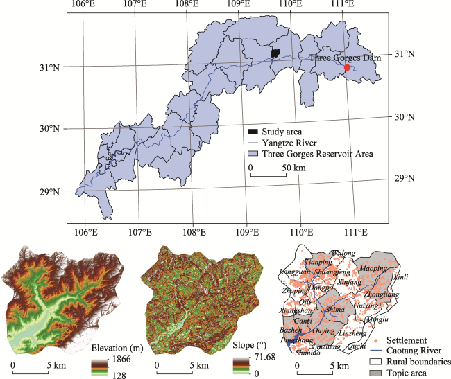
Figure 1 Location map of the study area (Caotangxi Watershed, Three Gorges Reservoir Area)

3 Theoretical analysis, materials, and methods

3.1 Theoretical model for agricultural landscape pattern transitions in mountainous areas

Rural, land use, and traditional agroecosystem transitions in mountainous areas (Long, 2012; Liang and Li, 2020) lead to spatial and temporal distribution changes in agricultural landscape elements. Such change inevitably creates agricultural landscape pattern transitions (Figure 2). Therefore, this study proposes the transition theory of agricultural landscape patterns based on the research of land-use transitions, traditional agroecosystem transitions, and cultivated land function transitions. Agricultural landscape pattern transitions refer to fundamental changes in the type, number, spatial distribution, and configuration of agricultural landscape components as caused by the long-term cumulative changes or mutations of agricultural land use and farmer behaviors. The agricultural landscape transforms from one pattern to another and from one function to another (or multiple functions) with a turning trend (Figure 3). The agricultural landscape pattern transitions also include that of land managers from households that meet subsistence to companies and enterprises that meet market needs as well as the transition of farmland functions from a single production to an ecological or eco-economy function. The agricultural landscape is laid out in good conditions areas; thus, the uniformity of the landscape spatial distribution is reduced. Meanwhile, field research and long-term thinking are utilized in this study to further propose that mountainous agricultural landscape patterns that do not completely follow the transition progress of pre-settlement, frontier, subsistence agriculture, intensifying agriculture, and intensive agriculture (Foley et al., 2005). The evolution of mountainous agricultural landscape patterns has shown uniqueness in recent decades, at least in China.
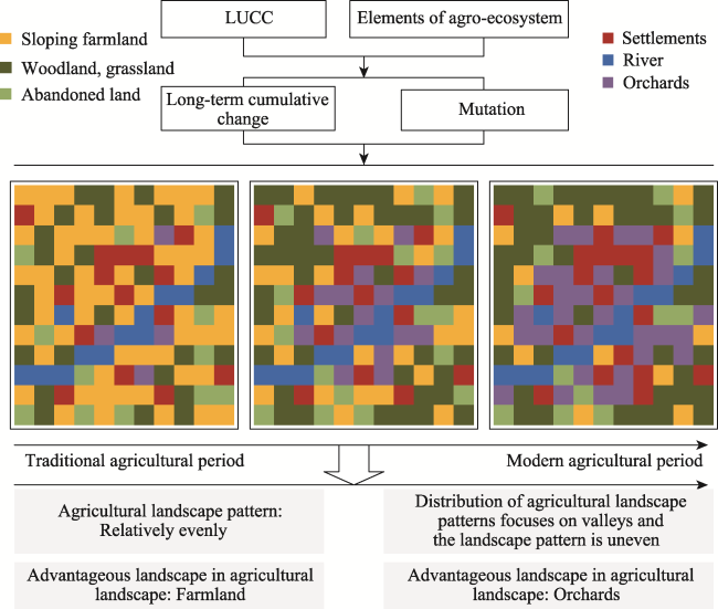
Figure 2 Sketch of the rural agricultural landscape pattern transitions in mountainous areas
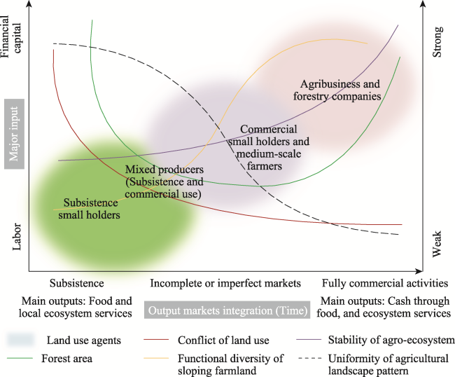
Figure 3 Theoretical framework of rural agricultural landscape pattern transitions in mountainous areas

3.2 Data sources and processing

This study used the Quick Bird high-definition remote sensing imagery as the data source, which was primarily Google Earth remote sensing data from 2000, 2010, and 2018 with a resolution accuracy of 0.51 m. Land use in the study area was divided into 11 types based on the land use classification methods described in the Resource and Environment Information Database of the Chinese Academy of Sciences using man-computer interactive interpretations. These include cultivated land, shrubland, forest land, orchards, abandoned farmland, township settlements, and rural settlements. Finally, the land use interpretation results were sampled and verified via field inspections. We used the FRAGSTATS 4.2 software to measure landscape patterns. Land-use type data were converted into a raster format with a 5-m resolution to fit the software requirements. The Digital Elevation Model (DEM) image data of the Caotangxi Watershed with a 30-m resolution were derived from the Geographical Information Monitoring Cloud Platform (http://www.dsac.cn/). The required data for the socioeconomic status were taken from Fengjie County’s statistical yearbooks in 2000, 2010, and 2018.

3.3 Research methods

3.3.1 Landscape index analyses

The landscape pattern index, which is a simple indicator to quantitatively analyze landscape structure compositions and spatial configurations, can reflect highly concentrated landscape pattern information (Wu, 2000). To comprehensively and simply reflect the landscape spatial characteristics, a set of landscape metrics was selected to analyze the landscape pattern characteristics from prior findings (Peng et al., 2010) and regional overviews. The selected class-level metrics included the percentage of landscape (PLAND), aggregation index (AI), landscape-level metrics included aggregation index (AI*), contagion (CONTAG), and Shannon’s diversity index (SHDI). Relevant studies have shown that these indices can greatly reflect the characteristics of landscape patterns (Peng et al., 2010). Definitions and their associated landscape interpretations and calculations are described elsewhere (Wu, 2000).

3.3.2 Moving window

This study applied a moving window combined with spatial metrics to analyze agricultural landscape transitions within the Caotangxi Watershed. The moving window, which is an effective method to analyze the spatial heterogeneity of landscape pattern indices (Kong and Nakagoshi, 2005), was first proposed by Whittaker to analyze vegetation changes along water gradients (Whittaker, 1960). It was then applied to study landscape heterogeneity in urban-rural interlaced zones (McDonnell and Pickett, 1990). This study selected 100 m as the size of the moving window and calculated and counted the selected landscape indicators within the window before finally observing spatial variations in the landscape patterns.

3.3.3 Selection of typical areas and determination of farming range

Changes in farmer settlements impact the utilization and transition of the sloping farmland system within farming areas (Ran, 2020). Bazhen Village, Ganzi Community, Ouying Village, Shima Village, Maoping Village, Zhongliang Village, and Tianping Village have large areas and obvious transitions of sloping farmland. Thus, they are selected as typical areas to analyze the fluctuations of the main agricultural landscapes within the farming range. Based on the “equalization method” of Jiao et al. (2006), this study superimposed buffer zones of 300, 400, and 500 m with landscape types and counted the areas of farmland, orchards, and abandoned land in each buffer zone. The statistical results show that the 400-m buffer zone around the settlements is the most appropriate space farming radius. As shown in Table 1, the cultivated land in this buffer zone reached more than 94% of the total cultivated land in each typical area, and the orchard area reached more than 99%.
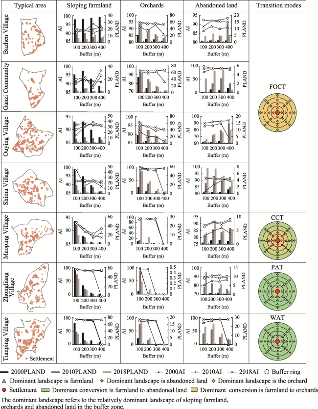
Table 1 Cultivated land, orchards, and abandoned land within a 400-m buffer zone of settlements in typical areas of Caotangxi Watershed, Three Gorges Reservoir Area
Topic area Total area (ha) Area in the 400-m buffer zone (%)
Cultivated land Orchards Abandoned land Cultivated land Orchards Abandoned land
Bazhen Village 219.57 247.40 33.04 94.79 99.27 98.75
Ganzi Community 123.59 160.15 20.25 98.98 100.00 87.51
Maoping Village 408.88 168.06 122.21 99.70 100.00 73.01
Ouying Village 598.94 693.00 108.14 99.69 99.55 95.02
Shima Village 491.28 437.73 102.70 99.79 99.48 98.46
Tianping Village 436.75 89.76 177.09 99.99 100.00 98.28
Zhongliang Village 319.99 1.14 104.68 99.76 100.00 99.46

Note: To unify the maximum buffer distance and ensure that the buffer zone contains all cultivated land, orchards, and abandoned land during the study period to the maximum extent according to the associated changing trends, the cultivated land data in the table is taken from 2000, and the orchards and abandoned land data are taken from 2018.

4 Results

4.1 Spatial and temporal characteristics of landscape patterns in the study area

The overall SHDI of the study area gradually increased, the CONTAG decreased year by year, and the AI* gradually increased from 2000-2018 (Table 2). This indicates that the landscape patterns of the study area tend to be diversified, and patches gradually fragment but become more aggregated, which is related to the emergence and expansion of abandoned land and orchard landscapes. The spatial characteristics of the landscape pattern indices show that there are obvious differences in the landscape patterns over different terrains. Namely, the landscape was heterogeneous in the river valley and homogenous in the non-river valley (Figure 4). There were no strong local spatial differences in the CONTAG, but the high-value area was transferred from the northwest of the study area with sloping farmland in 2000 to downstream with orchards in 2018. Meanwhile, the low-value CONTAG area was significantly reduced, which indicates an increased landscape agglomeration.
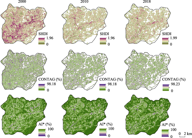
Table 2 Changes in landscape pattern indices for different years in the Three Gorges Reservoir Area
Year SHDI CONTAG (%) AI* (%)
2000 1.58 61.50 95.04
2010 1.74 59.03 95.97
2018 1.76 58.48 96.01
Figure 4 Spatio-temporal distributions of landscape pattern indices in the Caotangxi Watershed, Three Gorges Reservoir Area

4.2 Spatial pattern characteristics of the primary agricultural landscapes

The spatial and temporal changes in the PLAND and AI values on the spatial grid in the study area show that the spatial distribution of the sloping farmland, abandoned land, and orchards changed significantly from 2000 to 2018 (Figure 5). The sloping farmland was evenly distributed throughout the entire region and mostly concentrated in the valley at the northwest with gentle slopes in 2000. However, the sloping farmland in the entire region was significantly reduced and the patches were fragmented in 2018, but its dominant area was still in the valley at the northwest. Orchards were distributed primarily in the low-altitude areas of the southwestern riverbank and east tributary of the study area, and the PLAND and the AI were low, which indicates the patches were relatively fragmented in 2000. However, with the transition of rural household subsistence and the support of the government, the orchard distribution gradually expanded, and the agglomeration of orchards with larger patch areas increased along both sides of the river in 2018. The distribution pattern of abandoned land was spotty and disorderly in 2000. The abandonment of sloping farmland led to growth in area and density of abandoned land, and the advantageous area was above a 700-m elevation in 2018.
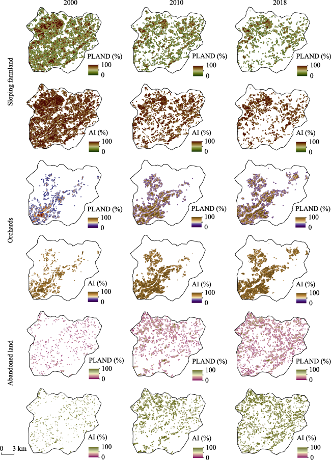
Figure 5 Spatio-temporal patterns of sloping farmland, orchards, and abandoned land in the Caotangxi Watershed, Three Gorges Reservoir Area in 2000, 2010 and 2018

4.3 Major agricultural landscape transitions within the farming range in typical areas

The sloping farmland and orchards in most typical areas were distributed in the 300-m buffer zone of the settlement during the study period, which results in different landscape indicesfrom the 400-m buffer zone (Figure 6). Therefore, only the primary trend is retained when analyzing changes in the landscape indices with different buffer distances. As the buffer distance increased, the sloping farmland and orchard PLAND and AI decreased and fluctuated in most areas. Among them, the sloping farmland PLAND in the Ouying Village and Ganzi Communities first increased and then decreased with the buffer distance, which shows a decreasing trend. The farmland PLAND and AI in Maoping, Zhongliang, and Tianping Villages decreased and fluctuated. Only the Bazhen Village sloping farmland area increased slightly with the buffer distance. This is because the 400-m buffer zone of the settlement in Bazhen Village contains less farmland (Table 1) and there is more cultivated land that was not counted. The abandoned land PLAND in Bazhen Village, Ganzi Community, Ouying Village, and Maoping Village increased and fluctuated with the buffer distance. The abandoned land AI in Bazhen, Ouying, Maoping, Zhongliang, and Tianping Villages increased and fluctuated with the buffer distance.
Figure 6 Changes in sloping farmland, orchards, and abandoned land within the farming range in typical areas of the Caotangxi Watershed, Three Gorges Reservoir Area
In terms of time, the sloping farmland PLAND within the buffer ring decreased and fluctuated from 2000 to 2018, while the abandoned land and orchard PLAND and AI values increased and fluctuated, which reflects the different degrees of farmland transformation into orchards and abandoned land near the settlements of typical areas. Bazhen Village, Ganzi Community, Ouying Village, and Shima Village located in the river valley had larger areas of sloping farmland within 400 m of settlements compared with orchards in 2000. However, the orchard area was larger than the sloping farmland in 2018, which shows these regions transformed dramatically and were used intensively. In 2000, the relatively dominant landscape within each buffer ring of Maoping Village settlements in the northeast was sloping farmland. By 2018, the dominant landscape transformed to orchards within 100 m, was unchanged within 100-200 m, and transformed to abandoned land within 200-400 m. This indicates the coexistence of abandonment and the intensive use of sloping farmland in Maoping Village. The sloping farmland of Tianping Village in the northwest changed to abandoned land and orchards within 100 m, but the sloping farmland still occupied a dominant position. However, beyond 100 m, the sloping farmland mostly transformed into abandoned land, which became the dominant landscape.
Four transition modes of agricultural landscape patterns can be summarized based on the agricultural landscape patterns as represented by sloping farmland, abandoned land, and orchards within the farming range in the above area (Figure 6):
(1) Sloping farmland-orchard conversion type (FOCT): The sloping farmland shrinks and the orchard quickly gathers and becomes a dominant landscape, such as in Bazhen Village, Ganzi Community, Ouying Village, and Shima Village.
(2) Comprehensive conversion type (CCT): The primary conversion is sloping farmland to orchards near the settlements, but farmland abandonment is mostly conversions far from settlements. The dominant landscapes from the settlement to the far regions are orchards, sloping farmland, and abandoned land, with Maoping Village as a typical example.
(3) Partially abandoned type (PAT): Sloping farmland abandonment occurs within the 400-m buffer zone of settlements, but sloping farmland is still the dominant landscape in most buffers. Abandoned land is the dominant landscape far away from settlements, with Zhongliang Village as a typical example.
(4) Wholly abandoned type (WAT): The proportion of orchards is small in the 400-m buffer zone of the settlements, and the conversion of sloping farmland to orchards is not strong. However, sloping farmland is transformed into abandoned land, which results in abandoned land becoming the dominant landscape, with Tianping Village as a typical example.

5 Discussion

5.1 Agricultural landscape pattern transition trends in the study area

Based on the analysis of the agricultural landscape pattern transitions in each typical area, we summarized four agricultural landscape pattern transition modes: FOCT, CCT, PAT, and WAT. The above modes are applied to all settlements in the watershed to explore each mode’s distribution over the entire region. As shown in Figure 7, there are other modes in the 400-m buffer zone of the study areas in addition to the FOCT, CCT, PAT, and WAT. However, the study area is dominated by the above four modes, and the spatial distributions of each model in each typical area conform to the overall characteristics of its agricultural landscape pattern transitions. Meanwhile, the FOCT and CCT are distributed primarily in the valley area, which coincides with the distribution pattern of orchards. The PAT and WAT are roughly consistent with the distribution space of cultivated land and abandoned land.
Figure 7 Transition results of agricultural landscape patterns in the Caotangxi Watershed, Three Gorges Reservoir Area
The FOCT, CCT, PAT, and WAT reveal the development process of agricultural landscape patterns in mountainous areas. Specifically, the PAT represents the starting point of mountainous agricultural landscape pattern transitions, which corresponds to the agricultural system model of traditional small-scale subsistence agriculture (Luo, 2017). The PAT has two transition trajectories in mountainous rural areas. One is driven by the transition of farmers’ livelihoods. They gradually transformed into CCT, and then with further expansions of the conversion of farmland to orchards, the agricultural landscape pattern transforms to intensive FOCT in good conditions areas. This is consistent with the essence of the HLH-LHL-LLH transition trajectory of the traditional agro-ecosystem in the TGRA (Liang and Li, 2020). The second is a transformation to WAT under the restrictions of the environmental or ecological needs, which is a manifestation of mountainous farmland degradation (Li and Li, 2018).
Some scholars have divided the progress of land-use transitions into pre-settlement, frontier, subsistence agriculture, intensifying agriculture, and intensive agriculture (Foley et al., 2005). However, these land-use stages and landscape pattern evolutions may only represent plain areas. Mountainous area land use and landscape pattern transitions are distinct from plains. This case study shows that the landscape pattern evolution in mountainous areas has unique characteristics (Figure 8). Unlike the unidirectional intensification of plain areas, the agricultural landscape pattern transitions in mountainous areas are bidirectional. Thus, the agricultural landscape patterns not only transform towards intensification but the abandonment of sloping farmland is also its notable feature. In addition, the agricultural landscape pattern transitions in mountainous areas also have vertical spatial changes. A larger terrain gradient gives a stronger ecological orientation of the agricultural landscape pattern transition; while a smaller terrain gradient gives a stronger economic orientation. Therefore, agricultural landscape pattern transitions in mountainous areas consist of a three-dimensional and two-way transition model. This paper uses typical case studies to reveal the transition and associated evolution processes and their particularities, which is a further development based on previous studies and has strong theoretical significance.
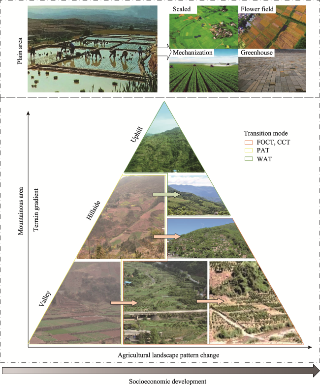
Figure 8 Comparison of changes in agricultural landscape patterns between mountains and plains. The mountainous photos in this picture are all taken by the research team in Caotang Town.

5.2 Agricultural landscape pattern transition mechanisms

This paper integrates qualitative and quantitative methods to analyze the driving mechanism of regional agricultural landscape pattern transitions from the aspects of nature, population, agricultural economy, and policies. As Caotang Town occupies about 90% of the Caotangxi Watershed, this paper uses the associated social and economic statistics to represent the watershed for the driving factor analysis. The landscape pattern presents a topographic gradient under the influence of topographic factors (Liang and Liu, 2010). The bivariate correlation analysis results from the SPSS software (Table 3) show that the PLAND and AI of abandoned land are positively correlated with the altitude, slope, and topographic relief. Moreover, all the results passed the significance test at the 0.01 level. The PLAND and AI of cultivated land and orchards are negatively correlated with these parameters. Elevation has the most obvious influence on the distribution of orchards. In altitudes suitable for orchards growth, the influences of the slope and topographic relief are not obvious. Therefore, the correlation between the slope and topographic relief with the landscape pattern indices of orchards is low. In addition, areas with extremely poor conditions are high-cover forests, so changes in the sloping farmland and abandoned land indices in these areas have a low correlation with the topographical factors. This illustrates that the topographical factors are not the primary contributors that affect the agricultural landscape pattern index changes in the study area. Liang and Li (2019b) also agree that the driving force of agricultural transitions in the TGRA are mainly social and economic factors at the township level.
Table 3 Correlations between agricultural landscape pattern indices and topographic factors
Terrain factor Sloping farmland Orchards Abandoned land
PLAND AI PLAND AI PLAND AI
Elevation -0.061 -0.099 -0.526 -0.552 0.019 0.006
Slope -0.067 -0.029 -0.121 -0.069 0.038 0.028
Topographic relief -0.140 -0.092 -0.214 -0.170 0.034 0.024
Figure 9 shows that under the constraints of topography, the settlements and their surrounding agricultural landscape pattern transitions in the watershed are concentrated primarily in the slope range of 10º-40º and the topographic relief of 80-240 m. From 2000 to 2018, the FOCT and CCT were concentrated mostly in the elevation range of 200-700 m, the PAT and the WAT were in areas above 700-m elevation, and the other modes were mainly distributed above 1000-m elevation.
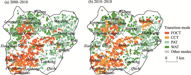
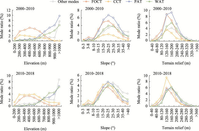
Figure 9 Spatial and temporal distributions of different modes for agricultural landscape pattern transitions in the Caotangxi Watershed, Three Gorges Reservoir Area
The rate of urban population in Caotang Town was only 1.99% in 1996 and reached 28.04% by 2017. Thus, the population urbanization rate has increased significantly (Figure 10a). The loss of labor in rural areas caused by urbanization is the most direct driving force for the transformation of rural land use in mountainous areas (Li and Li, 2017). Field interviews show that farmers’ dependence on land is gradually decreasing, and farmers’ main source of subsistence is mostly from non-agricultural income, such as working in cities. The loss of young and middle-aged male labor has led to an aging and feminized labor force in rural areas, which has increased the risk of farmland abandonment (Rey et al., 2007).
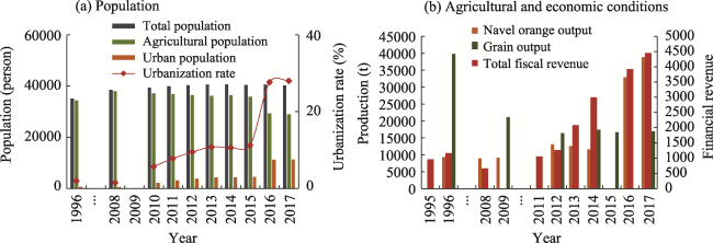
Figure 10 Partial socioeconomic statistics of Caotang Town
From 1995 to 2017, the output of navel oranges in Caotang Town increased significantly,while the grain output gradually decreased (Figure 10b). One reason is the increased orchard area and decreased farmland. In addition, improvements in navel orange planting technology and the large-scale management of orchards have grown navel orange outputs. Over the past 20 years, the annual fiscal revenue of Caotang Town and the living consumption level of local farmers have increased rapidly, which has provided a solid financial foundation for regional agricultural landscape pattern transitions.
Policy plays an important guiding role in land use and landscape pattern changes (Wang et al., 2007). The abandonment of sloping farmland and the formation of orchard landscapes in the region was promoted by the government’s Grain for Green Project (GGP) after 1998. Improvements in farmers’ subsistence required removing poverty and prosperity while prompting the transition of agriculture, which resulted in the rural labor force in mountainous areas transforming traditional farming into modern, part-time, and working-type farming. The ownership of farmland also significantly impacts the agricultural landscape patterns and functions (Sklenicka, 2016). During the study period, China implemented the land policy of the “Household Contract Responsibility System,” and each household's land in mountainous areas was scattered and fragmented. Therefore, the abandoned land landscape showed a dot-star rather than block-shaped distribution pattern when some farmers abandoned their farmlands. The continuous distribution of large orchards is inseparable from government support to develop the fruit industry (He et al., 2016). In general, the agricultural landscape pattern transitions in the mountainous areas of the TGRA are driven primarily by social and economic factors, which manifest as transitions from traditional and even agricultural landscapes of crops to the eco-economic win-win landscapes of the valley and the ecological landscape in higher altitudes (Figure 11).
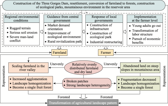
Figure 11 Transition driving mechanism of agricultural landscape patterns in mountainous areas of the Three Gorges Reservoir Area

5.3 Effects of agricultural landscape pattern transitions

The cropland landscape in the study area rapidly shrunk with the reconfiguration of land use structures and the transition of farmer subsistence. Specifically, it transformed into scattered and fragmented abandoned land in areas above 700-m elevation, and into intensive and contiguous economic orchards in low-altitude river valleys, which is an induced production substitution as driven by social and economic developments (Song and Li, 2019). The overall agricultural production landscape has transformed from a single and even distributed pattern to diversified as gathered at river valleys, and from a single-function agricultural landscape to an eco-economic win-win landscape. This is in line with the positioning of the soil and water conservation ecological function zone of the TGRA based on land and space development planning. Meanwhile, from the construction to operations of the Three Gorges Project, eco-economic win-win agriculture has gradually become the characteristic that drives the rapid economic development of each district and county under the implementation of land consolidation and forest protection projects in the TGRA (He et al., 2016; Liang and Li, 2019b). Scholars in other areas also agree that the economic orchard agriculture in mountainous areas coincides with the development mode of “poplar expansion and cropland shrinkage” in the North China Plain and “facility agriculture” in the Qinghai-Tibet Plateau (Zhao et al., 2012; Wei et al., 2019). This is an effective way to ensure a win-win situation for the regional economy and ecology (Lambin and Paracchini, 2010; Santos-matin, 2019), which also explains how China leads the world in green development through land consolidation at the watershed level (Chen, 2019).
It is noted that the agricultural landscape transition in the Caotangxi Watershed has improved soil erosion, and the development of orchards has allowed the region to achieve both ecological and economic benefits. However, the advantageous cropland landscape in the region has changed from seasonal cropland to a single perennial orchard landscape. This gives a smaller cropland ecosystem stability with less cropland diversity. The original purpose of planting orchards in the Caotangxi Watershed was to prevent soil erosion, but surveys found that farmers often removed weeds and shrubs under the trees to ensure the production of oranges, which resulted in bare soil and significant loss of soil nutrients. There is evidence that the supply of soil nutrients has become increasingly incompatible with the growth requirements of orchards, and soil quality is severely affected by the extension of orchard planting (Guo et al., 2010). Therefore, in the study area, a combination of orchards-vegetables and orchards-cash crops methods can be promoted to enhance the vegetation coverage of orchards, which is conducive to realizing the sustainable ecological and economic win-win of agricultural landscapes.
The farmland transition in mountainous rural areas has reduced the crop planting area, which may not be conducive to the country’s food security at the macro-level or to the regional economic development and farmers' subsistence security at the regional and household levels. However, mountainous land quality is poor, and grain products are low. There are examples in Western Europe and the United States that have proven that the intensive production of high-quality farmland in plain areas can offset the decreased grain production caused by mountainous area abandonment with poor-quality farmlands (Li, 2008; Zhao et al., 2016). The decline of the rural economy in mountainous areas means the optimization of the overall social and economic development layout of the region. Due to the spontaneous pursuit of farmers as rational economic individuals (Zhang et al., 2018), the non-agricultural benefits generated by the subsistence of farming transitions are often more than the benefits from farming (Shi and Yang, 2011). Therefore, mountainous rural land improvements should conform to the law of regional land-use transitions, follow the positioning of land and space development planning, and turn to comprehensively improve the quality of land and space utilization and the welfare of the people in the TGRA.

6 Conclusions

This paper introduces the theory of agricultural landscape pattern transitions in mountainous areas and verifies this in the Caotangxi Watershed based on studies of land-use transitions, the traditional agro-ecosystem transition, and the cultivated land function transition in mountainous areas. The results show that the overall diversity of the regional landscape increased but differences in local topography were obvious. This caused patches to become more fragmented but with a gradually increasing agglomeration from 2000 to 2018. This change is caused by the emergence and expansion of abandoned land at higher elevations and orchards along river valleys in the TGRA.
The mountainous area of the TGRA has four transition modes for agricultural landscape patterns: PAT, CCT, FOCT, and WAT. These four models reveal the bidirectional transition process of mountainous agricultural landscape patterns, which is specifically expressed as PAT-CCT-FOCT and PAT-WAT. Driven by economic and social factors, the agricultural landscape patterns in the mountainous areas of the TGRA have gradually transformed from a single and evenly distributed agricultural landscape of food crops to economic orchards of the valley and abandoned land at higher altitudes. This shows the transition process of the TGRA’s mountainous agricultural landscape patterns from a single function to the eco-economy win-win landscape pattern. This reflects the uniqueness of the evolution of mountainous agricultural landscape patterns; namely, the transition is a three-dimensional bidirectional transition model and is oriented by the economy of comprehensive intensification and the ecology of abandonment.
This paper lacks quantitative research on the economic and ecological effects of agricultural landscape pattern transitions. Therefore, we will evaluate the ecosystem service value of agricultural landscape transitions in future works. The spatial farming radius of rural settlements only reflects the straight-line distance between rural settlements and farming areas, while the actual farming distance in mountainous areas is often farther than 400 m. This paper mainly analyzed conversations of the sloping farmland transformation to abandoned land and orchards in the study area. However, there are a few tea gardens and greenhouses in the TGRA mountainous area, so the spatial characteristics of the regional agricultural landscape patterns may not be fully reflected. The research results still reveal the main transition directions and trends of the agricultural landscape patterns in the mountainous areas of the TGRA.
[1]
Chen C, Park T, Wang X H et al., 2019. China and India lead in greening of the world through land-use management. Nature Sustainability, 2: 122-129.

DOI PMID

[2]
Foley J A, Defries R, Asner G P et al., 2005. Global consequences of land use. Science, 309(5734): 570-574.

DOI

[3]
Fu B J, 1995. Analysis of agricultural landscape spatial pattern in loess region. Acta Ecologica Sinica, 15(2): 113-120. (in Chinese)

[4]
Fu B J, 2010. Three Gorges Project: Efforts and challenges for the environment. Progress in Physical Geography, 34(6): 741-754.

[5]
Fu B J, Hu C X, Chen L D, et al., 2005, Evaluating change in agricultural landscape pattern between 1980 and 2000 in the loess hilly region of Ansai County, China. Agriculture, Ecosystems and Environment, 114(2): 387-396.

DOI

[6]
Guo H C, Liao P F, Chen F S, 2010. Seasonal changes of soil nutrient supply and enzyme activities in navel orange orchards of south Jiangxi. Journal of Ecology, 29(4): 754-759. (in Chinese)

[7]
He W F, Yan J Z, Zhou H, et al., 2016. The micro-mechanism of forest transition: A case study in the mountainous areas of Chongqing. Journal of Natural Resources, 32(1): 102-113. (in Chinese)

[8]
Jiao Y M, Hu W Y, Su S H, et al., 2006. Spatial pattern and farming radius of Hani’s settlements in Ailao Mountain using GIS. Resources Science, 30(3): 66-72. (in Chinese)

[9]
Kong F H, Nakagoshi N, 2006. Spatial-temporal gradient analysis of urban green spaces in Jinan, China. Landscape and Urban Planning, 78(3): 147-164.

DOI

[10]
Lambin E F, Meyfroidt P, 2010. Land use transitions: Socio-ecological feedback versus socio-economic change. Land Use Policy, 27(2): 108-118.

DOI

[11]
Li S F, Li X B, 2017. Global understanding of farmland abandonment: A review and prospects. Journal of Geographical Sciences, 27(9): 1123-1150.

DOI

[12]
Li S F, Li X B, 2018. Economic characteristics and the mechanism of farmland marginalization in mountainous areas of China. Acta Geographica Sinica, 73(5): 803-817. (in Chinese)

[13]
Li X B, 2008. Theoretical hypotheses about agricultural land use changes and the relevant propositions about environmental impacts. Advances in Earth Science, 23(11): 1124-1129. (in Chinese)

[14]
Liang F C, Liu L M, 2010. Analysis on distribution characteristics of land use types based on terrain gradient: A case of Liuyang city in Hunan province. Resources Science, 32(11): 2138-2144. (in Chinese)

[15]
Liang X Y, Li Y B, 2019a. Spatio-temporal variation of farmland-fruit forest conversion and its enlightenment in Three Gorges Reservoir area: A case study on Caotangxi watershed. Journal of Natural Resources, 34(2): 385-399. (in Chinese)

DOI

[16]
Liang X Y, Li Y B, 2019b. Spatio-temporal features of scaling farmland and its corresponding driving mechanism in Three Gorges Reservoir area. Journal of Geographical Sciences, 29(4): 563-580.

DOI

[17]
Liang X Y, Li Y B, 2020. Traditional agroecosystem transition in mountainous area of Three Gorges Reservoir Area. Journal of Geographical Sciences, 30(2): 281-296.

DOI

[18]
Liang X Y, Li Y B, Zhou Y L, 2020. Study on the abandonment of sloping farmland in Fengjie County, Three Gorges Reservoir Area, a mountainous area in China. Land Use Policy, 97: 1-14.

[19]
Long H L, 2012. Land use transition and rural transformation development. Progress in Geography, 31(2): 131-138. (in Chinese)

[20]
Long H L, Liu Y S, Wu X Q, et al., 2008. Spatio-temporal dynamic patterns of farmland and rural settlements in Su-Xi-Chang region: Implications for building a new countryside in coastal China. Land Use Policy, 26(2): 322-333.

DOI

[21]
Luo S M, 2017. The transformation situation of agricultural ecology and the path of China’s ecological agriculture construction. Chinese Journal of Eco-Agriculture, 25(1): 1-7. (in Chinese)

[22]
McDonnell M J, Pickett S T A, 1990. Ecosystem structure and function along urban-rural gradients: An unexploited opportunity for ecology. The Ecological Society of America Ecology, 71(4): 1232-1237.

[23]
Pandey B, Karen C S, 2015. Urbanization and agricultural land loss in India: Comparing satellite estimates with census data. Journal of Environmental Management, 148: 53-66.

DOI

[24]
Peng J, Wang Y L, Zhang Y, et al., 2010. Evaluating the effectiveness of landscape metrics in quantifying spatial patterns. Ecological Indicators, 10(2): 217-223.

DOI

[25]
Pribadi D O, Stephan P, 2015. The dynamics of peri-urban agriculture during rapid urbanization of Jabodetabek Metropolitan Area. Land Use Policy, 48: 13-24.

DOI

[26]
Ran C H, Li Y B, Liang X Y, 2020. Effect of settlements change on land use in typical watersheds in the Three Gorges Reservoir area. Acta Ecologica Sinica, 40(12): 3879-3890. (in Chinese)

[27]
Rey B J, Martins A, Nicolau J, et al., 2007. Abandonment of agricultural land: An overview of drivers and consequences. CAB Reviews: Perspectives in Agriculture, Veterinary Science, Nutrition and Natural Resources, 2(57): 1-14.

[28]
Santos-matin F, Zorrilla-mias P, Garcia-llorente M, et al., 2019. Identifying win-win situations in agricultural landscapes: An integrated ecosystem services assessment for Spain. Landscape Ecology, 34: 1789-1805.

DOI

[29]
Shao J A, Zhang S C, Li X B, 2015. Farmland marginalization in the mountainous areas: Characteristics, influencing factors and policy implications. Journal of Geographical Sciences, 25(6): 701-722.

DOI

[30]
Shao J A, Zhang S C, Li X B, 2016. The role of rural farmland transfer in preventing farmland abandonment in the mountainous areas. Journal of Geographical Sciences, 26(2): 203-218.

DOI

[31]
Shi Z L, Yang Y Y, 2011. Migrant workers of rural labor ability development influence and policy implication. Management World, (12): 40-54. (in Chinese)

[32]
Sklenicka P, 2016. Classification of farmland ownership fragmentation as a cause of land degradation: A review on typology, consequences, and remedies. Land Use Policy, 57: 694-701.

DOI

[33]
Song X Q, Li X Y, 2019. Theoretical explanation and case study of regional cultivated land use function transition. Acta Geographica Sinica, 74(5): 992-1010. (in Chinese)

[34]
Tan M H, Li X B, Xie H, et al., 2004. Urban land expansion and arable land loss in China: A case study of Beijing-Tianjin-Hebei region. Land Use Policy, 22(3): 187-196.

DOI

[35]
Wan L H, Zhang Y W, Zhang X Y, et al., 2015. Comparison of land use/land cover change and landscape patterns in Honghe National Nature Reserve and the surrounding Jiansanjiang Region, China. Ecological Indicators, 51: 205-214.

DOI

[36]
Wang X H, Lu C H, Fang J F, et al., 2007. Implications for development of Grain-for-Green policy based on cropland suitability evaluation in desertification-affected north China. Land Use Policy, 24(2): 417-424.

DOI

[37]
Wang Y L, Han D, 2000. Ecological planning and designing in agricultural landscapes. Chinese Journal of Applied Ecology, 11(2): 265-269.

PMID

[38]
Wang Y Y, Li Y B, Shao J A, et al., 2014. Optimizing theory and case studies of cultivated slope land in the center of Three Gorges Reservoir area based on patch-scale land evaluation. Acta Ecologica Sinica, 34(12): 3245-3256. (in Chinese)

[39]
Wei H, Lu C H, Liu Y Q, et al., 2019. Spatial distribution and temporal changes of facility agriculture on the Tibetan Plateau. Resources Science, 41(6): 1093-1101. (in Chinese)

[40]
Whittaker R H, 1960. Vegetation of the Siskiyou Mountains, Oregon and California. Ecological Monographs, 30(3): 280-338.

[41]
Wu J G, 2000. Landscape Ecology:Pattern, Process, Scale and Hierarchy. Beijing: Higher Education Press. (in Chinese)

[42]
You H Y, 2017. Agricultural landscape dynamics in response to economic transition: Comparisons between different spatial planning zones in Ningbo region, China. Land Use Policy, 61: 316-328.

DOI

[43]
Yu H, Luo Y, Liu S Q, et al., 2015. The influences of topographic relief on spatial distribution of mountain settlements in Three Gorges Area. Environmental Earth Sciences, 74(5): 4335-4344.

DOI

[44]
Zhang B L, Gao J B, Gao Y et al., 2018. Land use transition of mountainous rural areas in China. Journal of Geographical Sciences, 73(3): 503-517. (in Chinese)

[45]
Zhao Y L, Li X B, Xin L J et al., 2012. Driving forces of “popular expansion and cropland shrinkage” in the North China Plain: A case study of Wen’an County, Hebei Province. Geographical Research, 31(2): 323-333. (in Chinese)

[46]
Zhao Y L, Zhang M, Li X B, et al., 2016. Farmland marginalization and policy implications in mountainous areas: A case study of Renhuai City, Guizhou. Journal of Resources and Ecology, 7(1): 61-67.

DOI

Outlines

/