Features of the long-term transformation of the Krasnodar reservoir, near the mouth of the Kuban River, Russia

  • POGORELOV Anatoly , 1 ,
  • LAGUTA Andrey 2 ,
  • KISELEV Evgeny 1 ,
  • LIPILIN Dmitry , 1, 3, 4, *
Expand
  • 1. Kuban State University, Krasnodar 350040, Russia
  • 2. Aerogematica LLC, Krasnodar 350063, Russia
  • 3. Kuban State Agrarian University Named after I.T. Trubilin, Krasnodar 350044, Russia
  • 4. Tuapse Branch of the Russian State Hydrometeorological University, Krasnodar Region, Tuapse 352800, Russia
* Lipilin Dmitry (1989‒), PhD Candidate and Assistant Professor, E-mail:

Pogorelov Anatoly (1956‒), PhD and Professor, specialized in the application of GIS in regional studies. E-mail:

Received date: 2021-03-04

  Accepted date: 2021-08-13

  Online published: 2022-02-25

Supported by

The Kuban Science Foundation in the Framework of the Scientific Project(МFI-20.1/123)

Copyright

Copyright reserved © 2021. Office of Journal of Geographical Sciences All articles published represent the opinions of the authors, and do not reflect the official policy of the Chinese Medical Association or the Editorial Board, unless this is clearly specified.

Abstract

The article considers the long-term (1941-2018) transformation of the Krasnodar valley reservoir, the largest in the North Caucasus. The main functions of the Krasnodar reservoir are irrigation of rice systems and flood protection of land in the Krasnodar reservoir region and the Republic of Adygea. According to topographic maps, Landsat satellite images (1974-2018) and field observations (2016-2018), four stages of transformation of the floodplain reservoir are identified. The selected stages are characterized by both natural causes (the transformation of the filling deltas into the extended deltas, etc.) and man-made causes (runoff diversions in the delta areas, etc.). The key factor of transformation is the formation of deltas of rivers flowing into the reservoir. Each of the selected stages, against the background of a gradual reduction in the area and volume of the reservoir, is characterized by the peculiarities of the formation of river deltas with the formation of genetically homogeneous sections of delta regions. During the period of operation of the reservoir, the delta of the main Kuban River moved up to 32.4 km and took away an area of 35.4 km2 of the reservoir. During the formation of the deltas of the Kuban and Belaya rivers, a bridge was formed on the Krasnodar reservoir. The evolution of the delta regions led to the division of the reservoir into two autonomous reservoirs. The total area of the delta regions was 85.9 km2 by 2018, i.e., 21% of the initial area of the reservoir. The transformation of the Krasnodar reservoir leads to a decrease in its regulated volume and gradual degradation.

Cite this article

POGORELOV Anatoly , LAGUTA Andrey , KISELEV Evgeny , LIPILIN Dmitry . Features of the long-term transformation of the Krasnodar reservoir, near the mouth of the Kuban River, Russia[J]. Journal of Geographical Sciences, 2021 , 31(12) : 1895 -1904 . DOI: 10.1007/s11442-021-1928-7

1 Introduction

The Krasnodar reservoir, located in the lower reaches of the Kuban River on the territory of two regions of the Russian Federation, is the largest artificial reservoir in the North Caucasus. The Kuban’s left tributaries: Belaya, Pshish, Marta, Apchas, Shunduk and Psekups are flowing into this valley reservoir, except the Kuban River. When operated in 1973, the reservoir had an area of about 400 km2, a length of 46 km, a width of up to 8-11 km, an average depth of 5.9 m, a maximum depth of 24.7 m, and a useful water volume of 2.2 km3 with a full capacity of about 3 km3 (Lurie et al., 2005). The main functions of the Krasnodar reservoir are irrigation of rice systems and flood protection. Thanks to the reservoir, it is possible to avoid flooding in the lower reaches of the Kuban River in situations with heavy precipitation and high snow flooding (Pogorelov et al., 2007; Rules, 2008; Belchikov et al., 2010).
An artificial reservoir changes the flow of water and sediments in seasonal and long-term plans (Berkovich, 2008). During the operation of the reservoir, its initial operational characteristics have significantly changed (mirror area, useful volume, average depths, etc. have decreased) (Kurbatova, 2012; Laguta and Pogorelov, 2018, 2019a; Litovka et al., 2019). In the mouths of rivers flowing into the reservoir, which have very high turbidity rates (Lurie et al., 2005, Alekseevsky et al., 2012; Lurie, 2002), the process of intensive delta formation has started (Laguta and Pogorelov, 2019b). The processes of transformation of the Krasnodar reservoir have not been sufficiently studied yet (Kurbatova, 2014; Pogorelov et al., 2017; Laguta and Pogorelov 2018; Laguta and Pogorelov, 2020). The observed changes in the reservoir (in fact, degradation), despite its economic significance, deserve a detailed quantitative analysis.

2 Materials and methods

The analysis of long-term and intra-annual transformations of the reservoir configuration was carried out using the data of Landsat satellite images (1974-2018) (Glovis.usgs.gov, McFeeters, 1996; Xu, 2006; Antonenko et al., 2015), topographic maps of 1940-1942, and field observations of 2016-2019. The interaction of the reservoir with the flowing rivers can be represented by transformation stages with geomorphological processes which are specific for these stages, changes in morphometric characteristics and corresponding signs of degradation of the reservoir. The gradual transformation of the reservoir is accompanied, first of all, by changes in the size of the deltas of the flowing rivers and the formation of areas of different genesis.
The GIS “Krasnodar reservoir” was created, which includes the initial data and the results of their processing. For the correct analysis of long-term changes based on the survey materials, the current level of the reservoir was taken into account. Each of the 376 satellite images used is assigned a name “level” based on the data at 8:00 a.m. (Kbvu-fgu.ru).

3 Results and discussion

The structure and stage transformation of the Krasnodar reservoir are closely related to the geomorphological features of the Kuban river valley in the area under study (Figure 1). The main factor influencing the change in the morphometric parameters of the reservoir is the delta formation of the main rivers flowing into it - the Kuban and Belaya rivers. River deltas are usually divided into two large groups (Credner, 1878; Mihajlov, 2001): a) Deltas of filling bays, estuaries, etc., and b) deltas of extension (extended deltas) formed in an open receiving reservoir. The development of estuaries of rivers has its own stages (Mihajlov et al., 2018). The stages of transformation of the Krasnodar reservoir are based on the stages of delta formation of the rivers of the receiving reservoir, which have a decisive impact on the transformation of the reservoir. Thus, the delta of the Belaya River began its formation in the Tshchik reservoir; later, the river flowed directly into the Krasnodar reservoir, and now it is a tributary of the Kuban River, which led to a significant change in the material balance in the delta of the main river.
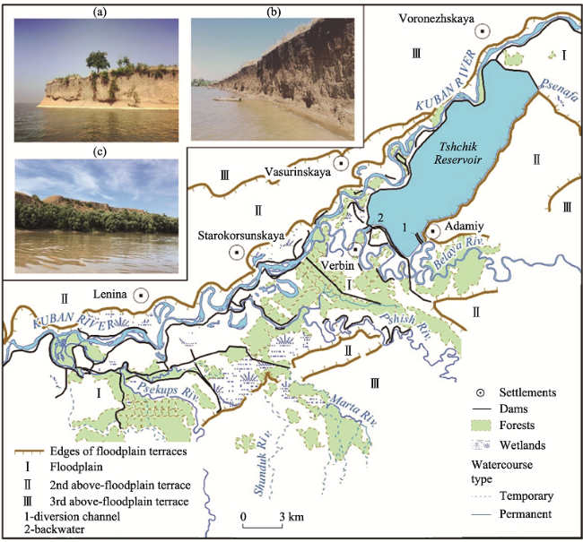
Figure 1 The valley of the Kuban River in the area of the Tshchik reservoir after its operation in 1941. Geomorphological situation: a) a wave-breaking cliff created on the edge of the 2nd above-floodplain right-bank terrace; an eastern suburb of the settlement of Lenin; b) a coastal cliff, created on the sideline of the 2nd above-floodplain left bank terraces in the interfluves of the Psekups River and the gully Gatskan; c) an edge of the 3rd above-floodplain terrace of the right bank near the settlement of Voronezhskaya
Within the analyzed period of 1941-2018, we have identified four stages, including the time of the existence of the Tshchik reservoir.
1) The first stage (1941-1975): The leading circumstance of the transformation is the formation of the delta extension of the Belaya River into the Tshchik reservoir.
2) The second stage (1976-1992) is the formation of the delta made by the Kuban River top of the Krasnodar reservoir between Ust-Labinsk and the village of Vasyurinskaya at full supply level (hereinafter NRL) in 33.65 m in the Baltic system of heights (hereafter BS); termination by the end of the phase controlled water exchange between the Tshchik and Krasnodar reservoirs in the development of the delta extension of the Belaya River.
3. The third stage (1993-2004) is the development of the delta extension of the Belaya River in two reservoirs with different levels of regimes (Krasnodar reservoir and separated Tshchik reservoir) in the conditions of the NRL equal to 32.75 m BS.
4. The fourth stage (2005-present): The river flows into the Kuban River; the beginning of the formation of the delta extension of the Kuban River in the open waters; fading during the phase of the Belaya River delta extension into the Krasnodar reservoir. The length of the dam is 32.4 km, and the height is 3.5-7.5 m (Kurbatova, 2014).

3.1 The first stage: 1941-1975

The Tshchik reservoir, which was later included in the Krasnodar reservoir, was built in 1941 and in the beginning it had a length of 16.6 km and a width of up to 5.2 km (Figure 2). The southeastern shore of the reservoir is bordered by the edge of the Kuban left bank terrace, and the northwestern, western and eastern are diked. The dam is 32.4 km long and 3.5-7.5 m high (Kurbatova, 2014). The northwestern longitudinal section of the dam separated the created reservoir directly from the Kuban riverbed, narrowing the floodplain of the river along its length to the width of 0.5-1.5 km. The inflow of water to the Tshchik reservoir was provided by the Belaya riverbed redirected to the formed reservoir below the village of Adamiy. The discharge was organized along the duct into the old Belaya riverbed in the area of the existing village of Verbin. Simultaneously with the operation of the economic facility, the formation of the “delta extension” of the river flowing into the reservoir started. To understand the mechanisms of transformation, it is important that by the time when the Krasnodar reservoir was put into operation and the delta of the Belaya River was included in its borders, the Belaya Delta had already been intensively formed for more than 30 years.
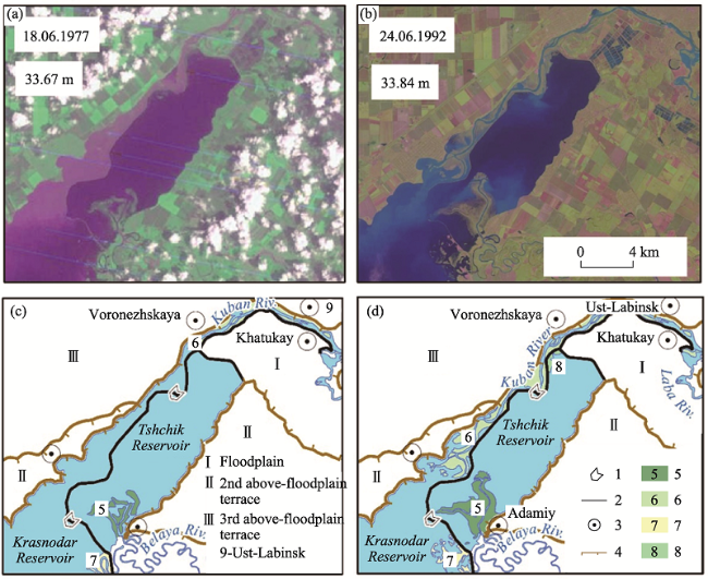
Figure 2 Dynamics of estuaries of rivers in the Krasnodar reservoir system in 1976-1992 (1. Water discharge structure and gateway in the Tshchik reservoir dam; 2. Tshchik reservoir dam; 3. Settlements; 4. Edges of the above-floodplain terraces; 5. Delta extension of the Belaya River in the Tshchik reservoir; 6. Delta of the estuary bay of the Kuban River; 7. Riverine ramparts of the old riverbed of the Belaya River; 8. Areas of shallow water overgrowth of the Tshchik reservoir)

3.2 The second stage: 1976-1992

Filling of the basin of the Krasnodar reservoir began in November 1972, but the level of the confluence with the Tshchik reservoir was reached in 1975. The design mark of the NRL (33.65 m BS) was reached in 1977. At this mark, the water levels in the Kuban River are provided with a backwater from the reservoir, which can be traced 17.8 km upstream from the village of Voronezhskaya. Backwater causes a decrease in the slope of the water surface, the speed of the river flow and, as a result, the transporting capacity of the watercourse, which leads to an increase in the riverbed marks and siltation of the upper part of the reservoir water area. As a result of the deposition of suspended sediments corresponding to the flow velocities, the formation of the “delta extension” of the Kuban River started. The intensity of its development at this stage has affected a relatively small area and width of the water surface over the direction of the Kuban River, limited by the right bank of the floodplain terrace, the Tshchik dam reservoir and the dike in the area of the village of Khatukay (Figure 2). By the end of the stage, the river almost restored its way to the village of Vasyurinskaya, but at the same time, during siltation, it significantly increased the marks of the bottom of the riverbed and floodplain that existed before the flooding.
Despite the merger, the Krasnodar and Tshchik reservoirs were separated by a dam throughout the entire joint operation (Figure 2), while having a connection through the discharge structure and gateways in the northern part of the Tshchik reservoir. The water masses in these reservoirs did not have a joint natural circulation and a single field of velocities. During this stage, the dam prevented most of the sediment of the Belaya River from entering the Krasnodar reservoir, localizing sediment deposition in the Tshchik reservoir. By 1988-1989, the delta extension of the Belaya River came close to the dam and almost separated the eastern part of the reservoir along with the discharge structure. One of the branches of the delta reached directly to the discharge structure, raising the level of the bottom in front of it and making it impossible to discharge water from the Tshchik reservoir to the Krasnodar reservoir through the sluices. The riverbed bifurcation appeared in the delta: the mainstream turned to the west along the dam, and released to the old riverbed of the Belaya River, which operated until 1941, the dam of 170 meters north of the water discharge facility was destroyed; the secondary channel turned to the east, into the Tshchik reservoir. Thus, regulated through the sluices and the water discharge facility, the water exchange between the Krasnodar and Tshchik reservoirs had actually stopped by this time.

3.3 The third stage: 1993-2004

The beginning of the stage is associated with a change in the operating mode of the Krasnodar reservoir - a decrease in the NRL by 0.9 m to 32.75 m BS. As a result, large littoral areas began to be drained during the year for a longer period, sufficient for the growth of shrub and tree vegetation. As a result, a solid “bridge” was finally formed in the waters of the reservoir between the villages of Adamiy and Vasyurinskaya (Figure 3). Essentially, the “bridge” presents as a restored “diked floodplain” characteristic for the lower reaches of the rivers with large sediment load and the high rate directional accumulation (Chalov, 2016). Here the submerged “saucers” are separated by relatively high riverbed watercourses.
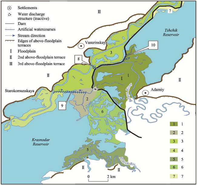
Figure 3 Genetic types of river mouth areas of rivers in the system of the Krasnodar reservoir in 2018 (1. Delta extension of the Belaya River into the Tshchik reservoir, growing continuously since 1941; 2. Delta extension of the Belaya River into the Krasnodar reservoir, developed with the end of the second stage and fading at the present time; 3. Delta of the estuary bay of the Kuban River, which developed from the entrance of the Krasnodar reservoir, has been in operation since 2004; 4. Delta extension of the Kuban River into the open water area of the Krasnodar reservoir, developing from 2004 to the present time; 5. Delta extension of the Pshish River; 6. Riverine ramparts of the old Belaya River; 7. Sections of overgrowing of shallow water in the Tshchik reservoir. Artificial watercourses: 8. Branch of the Belaya River in the Kuban River, built in 2004; 9. Branch of the Belaya River in the Kuban River, built in 2013; 10. Channel of the Belaya River in the Tshchik reservoir, built in 1990)
The autonomous (from the point of view of the distribution and accumulation of suspended sediments) existence of the Tshchik and Krasnodar reservoirs led to the excess of the southern part of the “bridge” separated by the dam over the northern one by an average of 0.5 m. The excess, in turn, contributed to an increase in the flow velocity at the point where the Belaya riverbed broke into the Krasnodar reservoir and increased the intensity of the formation of the extended delta at this stage (Figure 3). The Belaya River, which had previously been diverted into its old channel, silted it up and gradually cut through a new one in a westerly direction. At low water levels of the reservoir, the upper part of the reservoir was separated by the riverbed ramparts of the Tshchik reservoir, forming a temporary body of water supplied by the Belaya River. The flow of the river at the third stage during the period of maximum water discharge of the Krasnodar reservoir (September-October) did not participate in the total inflow, falling into the Tshchik and temporary reservoirs. Similar processes were observed in the Pshish River delta in 2001-2002: the river, which had previously restored its old (flooded) channel during the annual water discharge, broke through in a westerly direction, and now, at low reservoir levels, forms a temporary reservoir, bounded from the west by the riverbed of the Marta River. The situation is generally similar with the part of the Tshchik reservoir when a stepped longitudinal profile flooded floodplain crossed by the rivers tributaries, creates the preconditions to the separation of the upper parts of the reservoir by lowering the level of the upper reach. Seasonal changes in the levels of the Krasnodar reservoir with their development cycles prepare the breakthrough of the tributaries of the Kuban, located in the zone of variable backwater, in the adjacent relief depressions. Thus, the difference in the relief marks of the riverbed ramparts and the semi-closed depressions of the diked floodplain, that existed before the reservoir was filled, is leveled.
By the end of the stage, the mouth of the Kuban River moved to the main open part of the reservoir. The mechanism of a new stage - the formation of the delta extension - was activated at the border of the open water area.

3.4 The fourth stage: After 2004

The beginning of the next stage was the creation of the offtake from the riverbed of the Belaya River into the Kuban River at the site of the village of Vasyurinskaya (Figure 3) for water seizure and transfer into the Kuban River. It is known that measures of significant seizure of liquid runoff are accompanied by a radical restructuring of the sediment regime below the water discharge (Kondrat’ev et al., 1982). Thus, the channel connecting the rivers divided the flow of the Belaya River, partially directing it into the Kuban riverbed, which increased the process of sedimentation in its delta. To date, the near-shore ramparts, anchored by woody vegetation, have actually separated the water body near the village of Starokorsunskaya from the main basin of the Krasnodar reservoir (Figure 3).
On the contrary, the delta extension of the Belaya River has decreased its growth rate since 2004, and at present the rate of its change does not stand out against the background of the general transformation of the upper part of the reservoir. The marks of the bottom of the channels of the branches of the Belaya River delta below the branch are steadily growing, their river mouths are overgrown, and the last areas free of willows are littered with tree trunks lying on the bottom for up to 1.5 km. The flow through the river arms is carried out only at the levels above 32.2 m in the Tshchik or in the Belaya rivers. With a greater response of the Krasnodar reservoir according to the bathymetric survey of 2016 (Laguta and Pogorelov 2018), these river arms stopped functioning. In 2013, a new channel with a length of about 3.3 km was created between the Kuban and Belaya riverbeds (Figure 3). Such side river arms, being pumping, are quickly silted up (Chalov, 2016). So, through the “Kuban” section of the channel, the intensive siltation of the estuary bay of the Krasnodar reservoir began, with the channel turning into an inverse form at the bottom of the reservoir (Kurbatova, 2014).
The current regime of the Tshchik reservoir, which has become essentially autonomous, has its own peculiarities. During the period of high water on the Kuban River, received by the Krasnodar reservoir with a level close to the NRL, in the floodplain along the northwestern section of the dike, an excess of water levels above the level behind the dam is formed. This leads to a typical inflow of water into the Tshchik reservoir through the holes in the embankment dam, which is typical for this period. Water discharge from the reservoir at this time occurs through the channel into the bed of the Belaya River and then-until the separation into the branch into the Kuban River and the fading delta. The water level in the area near the mouth of the Belaya River, is in the backwater from the full Tshchik reservoir from the junction of the channel to it and up to the drainage. As a result, the part of the Kuban River’s flow falls into Tshchik reservoir, then from it to the Belaya River, and from there back to the Kuban River and partly into the Belaya River delta.
When the Krasnodar reservoir is operated and the flood subsides, the levels in the specified section of the Kuban River flow no longer provide filling of the Tshchik reservoir. At the same time, the reservoir is supplied only during periods of high water on the Belaya River. Part of the river flow in this time is over (back) to the Tshchik reservoir, continuing the formation of the delta extension, the other part (main) - on the discharge into the Kuban river, and the third, below discharge - in river arms of the fading delta. When the river levels drop below 32.2 m, the flow is carried out only by discharging it into the Kuban River, and the water volume in the Tshchik reservoir is preserved only by groundwater and discharges from reclamation systems. This situation contributes to increased eutrophication and pollution of this part of the reservoir, minimizing its ability to self-cleaning.
Information about length and rate of rise of the Kuban River delta for selected periods is given in Table 1.
Table 1 Dynamics of the Kuban River delta in the Krasnodar reservoir
Periods Linear growth of the delta (km) Average growth rate (km/year)
1976-1992 16.06 1.03
1993-2004 8.32 0.69
2005-2018 8.04 0.57
1976-2018 32.42 0.77
At the initial stage, the delta was formed in the conditions of a narrow estuarine bay, which provided a high rate of its formation. Later, when entering an open reservoir, the delta changed its type and stage of formation, and, despite the “increase” of the solid flow of the Belaya River, the speed of its movement to the dam decreased. In addition, the growth rate of the delta was affected by an increase in the length of the channel itself with a corresponding decrease in the slope of water surface of the stream and the flow rates. In this case, the proportion of sediments deposited within the delta itself increases. Table 2 shows the areas of selected locations that reflect the transformation of the Krasnodar reservoir in connection with the processes of delta formation.
Table 2 Formation of estuaries of rivers of the Krasnodar reservoir
Location Area (km2)
1975 1992 2004 2018
Total Including over NRL
Delta extension of the Belaya River into the Tshchik reservoir 4.05 7.65 16.35 19.82 7.10
Delta extension of the Belaya River into the Krasnodar reservoir - - 0.82 5.40 1.04
Delta of the Kuban River execution 4.15 13.47 25.62 27.85 16.76
Delta extension of the Kuban River - - - 13.56 1.36
Delta extension of the Pshish River - - 4.93 9.32 2.47
Sub-riverbed ramparts of the old riverbed of the Belaya River 2.16 4.17 7.07 11.57 4.95
Areas of littoral overgrowth in the Tshchik reservoir - 0.83 2.03 4.36 -
Tshchik reservoir - - - 48.68 -
Total 10.36 26.12 54.80 1405.6 33.69

4 Conclusions

According to Landsat satellite images, topographic maps and field studies, four stages of the transformation of the Krasnodar reservoir have been identified, starting with the formation of the Tshchik reservoir in 1941. The main reason for the morphological transformations of the basin is delta formation caused by the interaction of the receiving reservoir and the channels of the flowing rivers.
(1) The stages are characterized by natural causes (conversion of deltas of filling in the deltas of extension, etc.), coupled with anthropogenic causes (water runoffs in the delta areas, etc.). The processes of delta formation and division of the reservoir especially influenced by the local topography, in the first place - the presence in the floodplain of the Kuban riverbeds of diked channels of left tributaries. Among all the tributaries of the Belaya River, it is distinguished by increased water content and volumes of sedimentation.
(2) The specific division of the operation mode of the Krasnodar reservoir into periods with high and low levels led to the formation of two pronounced delta regions - the upper delta and the lower delta. During the delta formation of the Kuban and Belaya rivers, a “bridge” was formed in the Krasnodar reservoir, and the basin of the Tshchik reservoir was separated from the Krasnodar reservoir. The latter, having no regulated water exchange with the main basin, is now actually an autonomous reservoir with river power only during periods of flood on the Belaya River.
(3) According to our calculations, during the period of operation of the Krasnodar reservoir, the delta of the Kuban River flowing into it moved by 32.4 km, while taking off an area of 35.4 km2 at the reservoir. The total area of the delta regions that divided the reservoir into two independent basins was 85.9 km2 by 2018, i.e., 21% of the project area of the mirror. The observed transformation of the Krasnodar reservoir is accompanied by a significant decrease in its regulated volume and in the effectiveness of the flood control function.
[1]
Alekseevsky N I, Berkovich K M, Chalov R S et al., 2012. Spatial temporal variability of channel deformations on the rivers of Russia. Geography and Natural Resources, 3: 13-21. (in Russian)

[2]
Antonenko M V, Pogorelov A V, Yeletsky Yu B, 2015. Monitoring of the Kulikovo-Kurchanskaya group of estuaries (the Kuban River delta) in the area of the licensed area of Priazovneft LLC. Environmental Protection in the Oil and Gas Complex, 11: 55-63. (in Russian)

[3]
Belchikov V A, Borshch S V, Mukhin V M et al., 2010. Dangerous floods in the river basin. Kuban and methods of their forecasting. In: Collection: 80 Years of the Hydrometeorological Center of Russia. 1939-2010, St. Petersburg: Gidrometeoizdat, 401-422.

[4]
Berkovich K M, 2008. The principle of interaction between the flow and the channel and anthropogenic disturbances of the channel processes. Maccabean Readings, 19-27.

[5]
Chalov R S, 2016. Channel Processes (channel-study): A Tutorial. Moscow: INFRA-M, 565.

[6]
Credner G R, 1878. Die deltas, ihre morphologie, geographische, verbreitung, und entstehungs bedingungen. Petermans Geographische Mitheilungen (Erganzungsland), 12: 74.

[7]
Glovis.usgs.gov, 2021. The official site of the United States Geological Survey. Available at: Accessed 25 Jan. 2021].

[8]
Kbvu-fgu.ru. 2021. The official site of the Kuban Basin Water Administration of the Federal Agency of Water Resources. Available at: http://www.kbvu-fgu.ru/ Accessed 25 Jan. 2021].

[9]
Kondrat'ev N E, Popov I V, Snishhenko B F, 1982. Basics of Geomorphological Theory of the Channel Process. St. Petersburg: Gidrometeoizdat, 272.

[10]
Kurbatova I E, 2012. Space monitoring of negative situations in coastal zones of large water bodies. Current Problems in Remote Sensing of the Earth from Space, 9(2): 52-59. (in Russian)

[11]
Kurbatova I E, 2014. Transformation monitoring of the Krasnodar reservoir using high resolution satellite data. Current Problems in Remote Sensing of the Earth from Space, 11(3): 42-53. (in Russian)

[12]
Laguta A A, Pogorelov A V, 2018. Peculiarities of Krasnodar water reservoir silting. Evaluation based on the data of bathymetric surveys. Geographical Bulletin, 4(47): 54-66, DOI: 10.17072/2079-7877-2018-4-54-66. (in Russian)

DOI

[13]
Laguta A A, Pogorelov A V, 2019. Changes in the morphometric characteristics of the Krasnodar reservoir during the period of operation (1973-2018). In: Proceedings of the International Conference «InterCarto. InterGIS», 25(2): 5-15. (in Russian)

[14]
Laguta A A, Pogorelov A V, 2019. Transformation of the Krasnodar reservoir (1941-2018). Bulletin of Higher Education Institutes North Caucasus Region. Natural Sciences, 3: 45-54. (in Russian)

[15]
Litovka F S, Bandurin M A, Vanzha V V, 2019. Ways to solve the problem of silling of the Krasnodar reservoir for rational use of water resources of floodland territories. Engineering Journal of Don, 8(59): 32-48. (in Russian)

[16]
Lurie P M, Panov V D, Tkachenko Ju Ju, 2005. Kuban River: Hydrography and Flow Regime. St. Petersburg: Gidrometeoizdat, 498.

[17]
Lurie P M, 2002. Water Resources and Water Balance of the Caucasus. St. Petersburg: Gidrometeoizdat, 506.

[18]
McFeeters S K, 1996. The use of Normalized Difference Water Index (NDWI) in the delineation of open water features. International Journal of Remote Sensing, 17: 1425-1432.

DOI

[19]
Mihajlov V N, Mihajlova M V, Magrickij D V, 2018. Basics of River Mouths Hydrology. Moscow: Triumph Publishing, 314.

[20]
Mihajlov V N, 2001. River deltas: Structure, formation, evolution. Soros Educational Journal, 7(3): 60-66. (in Russian)

[21]
Pogorelov A V, Laguta A A, 2020. On the circulation of waters in the valley reservoir (Krasnodar reservoir). Bulletin of higher education institutes North Caucasus region. Natural Sciences, 4: 87-97. (in Russian)

[22]
Pogorelov A V, Lipilin D A, Kurnosova A S, 2017. Satellite monitoring of the Krasnodar reservoir. Geographical bulletin, 1(40): 130-137, DOI: 10.17072/2079-7877-2017-1-130-137. (in Russian)

DOI

[23]
Pogorelov A V, Salpagarov A D, Kiselev E N, et al., 2007. Geoinformation method in the practice of regional physiographic studies. In: Proceedings of the Teberda State Biosphere Reserve, 45, 200.

[24]
Rules for the use of water resources of the Krasnodar reservoir, 2008. Krasnodar: Kubanvodproekt, 158.

[25]
Xu H, 2006. Modification of normalized difference water index (MNDWI) to enhance open water features in remotely sensed imagery. International Journal of Remote Sensing, 27: 3025-3033.

DOI

Outlines

/