Quantitative relationship between channels and bars in a tidal reach of the lower Yangtze River: Implications for river management

  • YANG Yunping , 1, 2 ,
  • ZHENG Jinhai 1 ,
  • ZHANG Wei 1 ,
  • ZHU Yude , 2, * ,
  • CHAI Yuanfang 3 ,
  • WANG Jianjun 2 ,
  • WEN Yuncheng 4
Expand
  • 1. State Key Laboratory of Hydrology-Water Resources and Hydraulic Engineering, Hohai University, Nanjing 210098, China
  • 2. Tianjin Research Institute for Water Transport Engineering, Ministry of Transport, Tianjin 300456, China
  • 3. Vrije Universiteit Amsterdam, Department of Earth Sciences, Boelelaan 1085, 1081 HV Amsterdam, the Netherlands
  • 4. Nanjing Hydraulic Research Institute, Nanjing 210029, China
* Zhu Yude (1979-), Researcher, E-mail:

Yang Yunping, PhD and Research Assistant, E-mail:

Received date: 2020-08-20

  Accepted date: 2021-03-09

  Online published: 2022-02-25

Supported by

National Natural Science Foundation of China(51809131)

National Natural Science Foundation of China(U2040203)

Open Foundation of State Key Laboratory of Hydrology-Water Resources and Hydraulic Engineering(2017491211)

Fundamental Research Funds for Central Welfare Research Institutes(TKS20200404)

Fundamental Research Funds for Central Welfare Research Institutes(TKS20200312)

Copyright

Copyright reserved © 2021. Office of Journal of Geographical Sciences All articles published represent the opinions of the authors, and do not reflect the official policy of the Chinese Medical Association or the Editorial Board, unless this is clearly specified.

Abstract

Deep-water navigation channels in the tidal reaches of the lower Yangtze River are affected by water and sediment fluxes that produce complex shoals and unstable channel conditions. The Fujiangsha reach is particularly difficult to manage, as it has many braided channels within the tidal fluctuation zone. In this study, hydrologic and topographic data from the Fujiangsha reach from 2012 to 2017 were used to examine the variations in deposition and erosion, flow diversion, shoals, and channel conditions. Since the Three Gorges Dam became operational and water storage was initiated, the Fujiangsha reach has shown an overall tendency toward erosion. Channels deeper than 10 m accounted for 83.7% of the total erosion of the Fujiangsha reach during 2012-2017. Moreover, the dominant channel-forming sediments have gradually changed from suspended sediments to a mixed load of suspended and bed-load sediments. Deposition volumes of these sediments has varied significantly among different channels, but has mainly occurred in the Fubei channel. Furthermore, periodic variations in the Jingjiang point bar have followed a deposition-erosion-deposition pattern, and the downstream Shuangjian shoal mid-channel bar has been scoured and shortened. Approximately 44.0% of the bed load from the upstream Fujiangsha reach is deposited within the 12.5-m deep Fubei channel. The increased erosion and river flow from the Jingjiang point bar and the Shuangjian shoal during the flood season constituted 59.3% and 40.7%, respectively, of the total amount of siltation in the Fubei channel.

Cite this article

YANG Yunping , ZHENG Jinhai , ZHANG Wei , ZHU Yude , CHAI Yuanfang , WANG Jianjun , WEN Yuncheng . Quantitative relationship between channels and bars in a tidal reach of the lower Yangtze River: Implications for river management[J]. Journal of Geographical Sciences, 2021 , 31(12) : 1837 -1851 . DOI: 10.1007/s11442-021-1925-x

1 Introduction

With the ongoing economic and social development in the lower Yangtze River Basin, the volume of sediments transported along the river has steadily increased, and the Yangtze River has ranked first in freight volume globally for many years (Yang et al., 2019). Deep-water channels accommodating the associated shipping activities have been gradually extended from the estuary to upstream of the tidal influence. For example, a 12.5-m deep navigation channel was first extended through the north passage of the Yangtze River Estuary in 1998-2010, followed by extensions to the Tiansheng port in 2012-2014 and Nanjing in 2015-2017. These extensions represented early achievements in the goal to extend a trunk channel up the Yangtze River (Yang et al., 2017, 2019).
The water depth of these channels is maintained through various means, including dredging, dikes, beach protection belts, and bank protection (Noh et al., 2012). Waterway regulation is achieved through revetments and riprap protection. The revetments are installed on riverbanks or central bars, and the riprap protection covers the low beach parts of the point or the central bars. Dredging measures are necessary to prevent obstructions to navigation through the shipping channels, and despite this, the phenomenon of aback-silting occurs during and after the dredging process. The volume of back-silting is related to the type of sediments, and the sediment source is responsible for scouring the river islands in the vicinity of shipping channels. Thus, conducting a riverbed evaluation of river islands in the vicinity of the shipping channels and examining the siltation volume is of great importance. Such evaluation is particularly important in areas with many braided channels, such as the waterways in Jiepai (Liu et al., 2014), Dongliu (Liu et al., 2013), and Luochengzhou (Yang et al., 2020). Former studies have suggested that the periodic erosion and deposition of point and central bars and the associated sediment transportation directly influence the condition of the downstream braided channels, with point bars being particularly influential (Zhang et al., 2016).
Since the Three Gorges Dam (TGD) became operational in 2003, there has been an increase in erosion in the middle and lower reaches of the Yangtze River (Dai et al., 2016; Yang et al., 2018, 2019), impacting the tidal reach there (Wang et al., 2009; Song et al., 2015). During 1959-2003, before the TGD operation began, combined erosion and deposition of the riverbed changed to erosion only of the Datong to Xuliujing reach (Wang et al., 2009). However, in 2006-2011, during the construction of the TGD, a thalweg incision occurred in the Nanjing reach (Dai and Liu, 2013). According to the Yangtze River Sediment Bulletin, riverbeds in the Yangzhong reach (CWRC-MWR, 2017) and Chengtong reach (CWRC-MWR, 2016) were scoured after the TGD became operational. A negative relationship was observed between the increased split ratio of the Fushajiang channel and the decreased water flow (Chen et al., 2016). Moreover, the Jingjiang point bar had the most significant influence on the channel conditions and braided channel stability in the Fubei channel (Wen et al., 2018; Wang et al., 2020). Regarding the maintenance of the 12.5-m deep waterway in the lower reaches of Nanjing in the Yangtze River, the maintenance in the Fujiangsha reach was the most extensive, with a focus on the Fubei channel (Li and Leng, 2017). Sometimes, this channel still needs to be closed for dredging because of the high ship density that increases the risk of navigational safety (Jin, 2018). The Fubei channel is closely related to the evolution of nearby shoals and beaches and to adjustments in the flow direction through the river branches. Hence, a high priority for current research is to determine the quantitative relationship between and relative influential weights of the evolution of point bars and the evolution of mid-channel bars, as well as the amount of erosion and deposition in the channel of the 12.5-m waterway. In recent years, the dredging volume in the Fujiang reach has been the largest among all the channels of the Nanjing-Liuhekou reaches in the Yangtze River. In 2010-2016 for instance, the dredging volume of the Fubei channel accounted for 69% of the total dredging volume of the Nanjing-Liuhekou reaches (Li and Leng, 2017). During this period, at a pre-existing waterway with a depth of 10.5 m, the waterway water depth decreased within a year, meaning dredging was required during the dry season. However, the water depth also decreased within the same year at a waterway with a depth of 12.5 m. Therefore, dredging was required during the entire year, both in the flood and dry seasons. In these two scenarios, there was an increasing need for dredging of the channels (Wang et al., 2020). The Fujiangsha reach near the river’s mouth is braided at multiple levels during the flood season, and therefore, it requires a considerable dredging volume. Owing to the fact that the point bars are maintained under natural conditions, this location is considered a representative area for research on the influence of the bars on the channel conditions.
This study used observed water and sediment data from 2012 to 2017, along with topographic data, to analyze the flow and sediment diversion ratios and changes in erosion and deposition in the channels of the Fujiangsha reach. Quantitative relationships between the amount of erosion and deposition in the channel, point bars, and mid-channel bars were established, and the relationship between these characteristics and the flow was investigated. Finally, the relative influential weight of each factor was determined.

2 Materials and methods

2.1 Study area

The Fujiangsha reach (Figure 1a) is braided at two levels and divided into the Fuzuo and Funan channels by Fujiang Island and into the Fuzhong and Fubei channels by Minzhu Island (Figure 1b). The head of Minzhu Island is formed by a sediment tongue grading into the Shuangjian shoal. The operations of the TGD and other upstream reservoirs have affected the water and sediment flux in this reach, leading to several local conservation projects. As part of the Shuangjian shoal conservation project (2009-2011), a submerged breakwater was built at the head of the shoal as well as longitudinal dikes along its northern and southern boundaries. During the second stage of the 12.5-m deep-water channel conservation project (2015-2017), the following objects were constructed: four spur dikes on the left side of Fujiang Island, a submerged dike at the head of the Shuangjian shoal, four spur dikes to the north of the submerged dike, three spur dikes to the south of the submerged dike, and five spur dikes to the south of the southern boundary of the Shuangjian shoal.
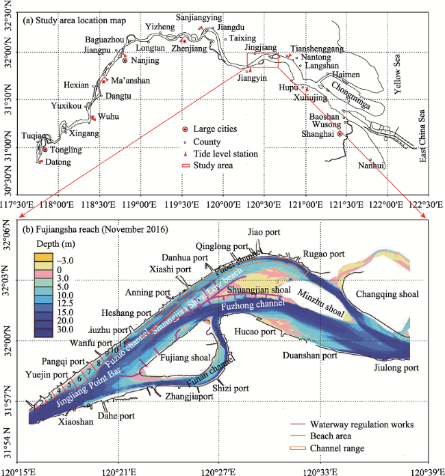
Figure 1 Fujiangsha reach: (a) geographical location of the study area located at the tidal reaches of the lower Yangtze River; (b) engineering layout of the marshland and branches

2.2 Research materials and parameters

In this study, we collected the measured annual and daily average discharge and sediment transport rate from the Datong hydrometric station from 1980 to 2017 to analyze their variation. Hydrological and sediment data from the Fujiangsha reach from 2013 to 2017 were also collected. The measurements were obtained twice a year, in February and August. The duration of a single measurement was approximately 15-20 days. The measurement of the water flow was acquired with an acoustic doppler current profiler (ADCP, United States Teledyne Technologies), and the branching ratio was calculated using the flow rate at ebb tide. Based on the requirements of the Chinese Code of Hydrology for Inland Navigation Engineering (JTS145-1-2011), the lateral spacing between the sampling spots was 100 m, and the fore-and-after measured spacing was 2000-3000 m. Filtration drying of sediment was carried out, and the suspended sediment was weighed using 1:10,000 electronic balances. The locations of the measurements of suspended sediment and flow velocity were the same. Topographic surveys were carried out by a differential global positioning system (DGPS) combined with an echo sounder, with a scale of 1:10,000. Specific parameters are listed in Table 1.
Table 1 Materials used in the study and parameter comparison
No Content Instruments/methods Measuring density Research content
1 Flow rate Acoustic doppler current profiler (ADCP) The transverse interval is 100 m and the longitudinal section interval is 2000-3000 m. Calculating diversion ratio of branching channels and analyzing the hydrodynamic changes in the marginal beach area.
2 Sediment concentration Filtration drying weighing method Weighing with 1:10,000 electronic balance Analyzing the sediment transport process and the suspended sediment concentration of the Xiaoshan section.
3 Topography Differential global positioning system (DGPS) combined with echo sounder A scale of 1:10,000 Analyzing the scouring and silting amounts and distributions of the rivers and researching the relationship between the evolution of the marginal shoal and the erosion and siltation of the navigation channel.

2.3 Analysis of water and sediment conditions

Datong hydrometric station is the last hydrological control station in the lower Yangtze River. There is no large-scale channel between Datong and Xiaoshan (at the head of the Fujiangsha reach) that has flow conditions typical of the study area (Chen et al., 2003). Within the Fujiangsha reach, a comparison of the data from the periods 1980-2002 and 2003-2017 (i.e., before and after the TGD became operational) showed that the volume of flow decreased by 6.9%, and the sediment discharge decreased by 63.5% (Figure 2a). There was a good correlation between the suspended sediment concentration recorded at the Xiaoshan and Datong stations (Figure 2b); that is, when the suspended sediment concentration at the Datong station decreased, a decrease was synchronously recorded at the Xiaoshan station (Yang et al., 2014, 2015). Previous studies have shown that the critical diameter of particles in the channel-forming sediments below Xiaoshan was 0.1 mm, and that the median diameter of grains decreased in the suspended sediments (SS) at the tidal limit (Wang et al., 2009; Luo et al., 2012). This indicates that the channel-forming effect of SS was reduced after the TGD became operational.
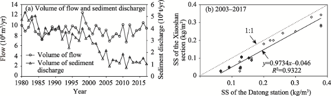
Figure 2 Variations in water and sediment conditions in the Fujiangsha reach before and after the TGD became operational (a); comparison of suspended sediments (SS) as recorded at the Datong and Xiaoshan sections (b)

2.4 Flow and sediment diversion ratios in the braided channels

During 2012-2017, the flow and sediment diversion ratios (FSDRs) in the Funan and Fuzhong channels in the dry seasons were higher than those in the flood seasons, whereas the reverse was true in the Fubei channel (Figure 3a). Based on the relationship between the flow diversion ratio and flow rate, Funan and Fuzhong are dry season-braided channels, whereas Fubei is a flood season-braided channel (Chen et al., 2016; Han et al., 2018). FSDR trends between December 2012 and May 2015 and those between August 2015 and February 2018 in the Funan channel increased by 0.2% and decreased by 1.1%, respectively (Figures 3b-1 and 3b-2); those in the Fuzhong channel increased by 2.6% and 1.9%, respectively (Figure 3b-3); and those in the Fubei channel decreased by 2.8% and 0.9%, respectively (Figure 3b-4).
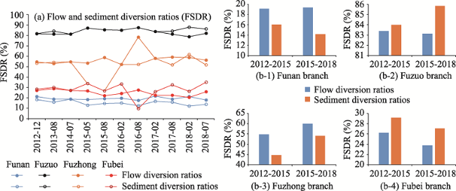
Figure 3 Flow and sediment diversion ratios (FSDRs) in the braided channels of the Fujiangsha reach. (a. FSDRs; b-1. FSDRs in the Funan reach; b-2. FSDRs in the Fuzuo reach; b-3. FSDRs in the Fuzhong reach; b-4. FSDRs in the Fubei reach
The size of the sediment ripples on the riverbed near the tidal limit is considered to be influenced by channel-forming, bed-load sediments (Zheng et al., 2016, 2018), and the bottom sediment transport in the Fujiangsha reach is considered to have bed-load motion characteristics. The sediment concentrations in this area, as computed using the Rousse equation, reached 15-20 kg/m3, implying that the channel-forming sediments mainly contained near-bottom sediments with bed-load movement characteristics on the riverbed (Liu et al., 2011). The sediment-laden capacity formula (Eq. 1), as presented by Dou (1995), can be used to derive the characteristics of suspended load and bed load, which can reflect the bottom sediment transport conditions and intensity while revealing the differences between branching channels. This reliable formula is widely used in simulations of sediment transport in tidal reaches and estuaries. For example, Cao et al., (2009) compared sediment-carrying capacities using the equations by Dou (1995) and showed that the equation-derived results were largely consistent with the measured values, both before and after the impoundment of large reservoirs. The formula stated by Dou (1995) is as follows:
${{Q}_{b}}=\frac{k}{C_{0}^{2}}\frac{{{\gamma }_{s}}\gamma }{\gamma -{{\gamma }_{s}}}h(V-{{V}_{c}})\frac{{{V}^{3}}}{gh\omega }$
where V is the near-bottom velocity (m/s), Vc is the critical incipient velocity with a value of 0.42 m/s, ${{\gamma }_{s}}$is the bulk density of sediment, $\gamma $ is the bulk density of water, ω is the sedimentation velocity given as $\omega =1.72\sqrt{\frac{{{\gamma }_{s}}-\gamma }{\gamma }gD}$, D is the sediment particle size, C0 is the dimensionless Chezy’s coefficient, k is an undetermined constant with a value of 0.01, g is the acceleration due to gravity with a value of 9.80 (m2/s), and h is the water depth (m).
The Funan channel carried approximately 24.0% and 9.0% of the bed-load sediments during the dry and flood seasons, respectively; the Fuzuo channel carried 76.0% and 91.0%; the Fuzhong channel carried 27.4% and 16.4%; and the Fubei channel carried 48.6% and 74.6%, respectively (Figures 4a and 4b). Thus, the Fubei channel was the main transportation route for bed-load sediments remaining at a higher proportion of the total bed-load sediments than that of suspended sediments.
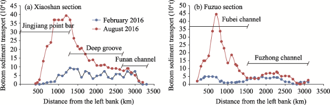
Figure 4 Distribution of bed-load sediments among channels in the Fujiangsha reach (a. Xiaoshan section; b. Fuzuo section)

3 Results and discussion

3.1 Riverbed evolution of point and middle-channel bars

3.1.1 Erosion and deposition in the channels
From August 2001 to October 2016, the Fujiangsha reach had an overall erosive tendency, with 83.7% of the erosion concentrated in channels at depths greater than 10 m. The locations that experienced the strongest amounts of erosion were the upstream and downstream ends of the Jingjiang point bar, the entrance to the Fuzuo channel, the upstream and right side of the Shuangjian shoal, and the area from Jiulong port to Xijie port (Figure 5a). In the periods from August 2001 to May 2006, May 2006 to July 2011, and July 2011 to October 2016, channel erosion at depths greater than 10 m accounted for 90.0%, 58.6%, and 110.9% of the total erosion, respectively (Figure 5b-1). Values higher than 100% mean that the riverbed deeper than 10 m was scoured, and that shallower than 10 m was deposited. Values smaller than 100% mean that the riverbed was scoured regardless of the depth. During these three periods, the sediment transportation mechanism in the section from Xiaoshan to Wangqiao changed from deposition to erosion, the section from Wangqiao to Xiashi continued to erode (sediment transportation first increased and then decreased), the section from Wangqiao to Hucao changed from erosion to deposition, and the section from Xiashi to Xijie maintained high levels of erosion (Figure 5b-2).
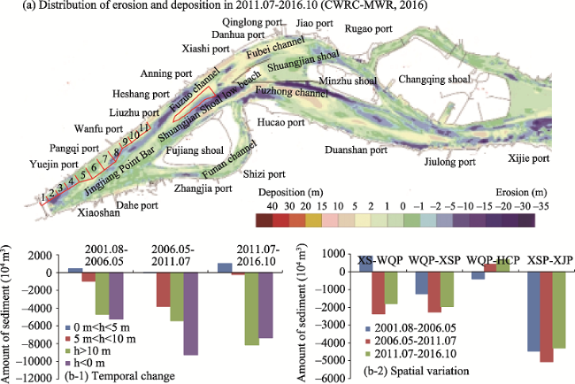
Figure 5 Erosion and deposition patterns in the Fujiangsha reach from August 2011 to October 2016 in terms of (a) map view, (b-1) erosion amount; and (b-2) individual reaches between Xiaoshan (XS), Wangqiao port (WQP), Xiashi port (XSP), Hucao port (HCP), and Xijie port (XJP). (b) Positive values represent siltation and negative values represent scouring
3.1.2 Interannual morphological variations in the Jingjiang point bar
Taking the 12.5-m depth contour as the research object, the sand tongue of Shuangjian shoal was connected with the beaches of Fujiang shoal (Figure 6a) before 2010, yet they have been separated since 2010, and the front of the sand tongue retreated (Figures 6b-6d). The end of the beaches in the Jingjiang point bar moved downstream in the form of cuts. The cutting phenomenon was more significant during years of abundant water (Figure 6b). For instance, in 2010, during the implementation of the second phase of the project, the development scale of the beaches in the Jingjiang point bar was smaller than that before the project began. Thus, the sand tongue of Shuangjian shoal and the beaches of Fujiang shoal were separating.
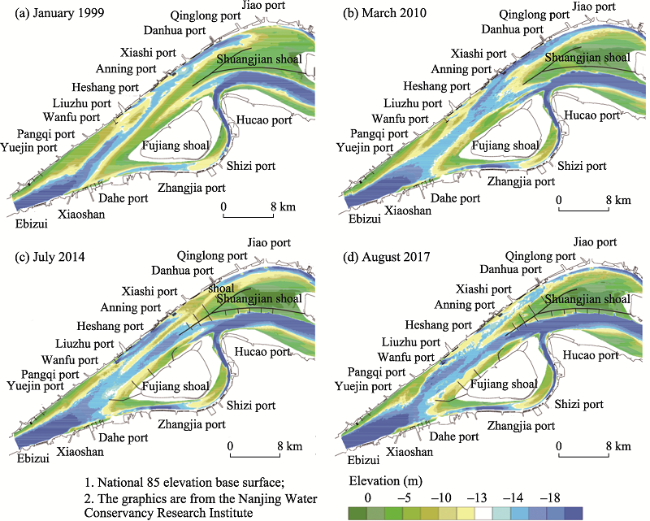
Figure 6 Morphological variations in the Jingjiang bar and Shuangjian shoal mid-channel bar over time
3.1.3 Intra-annual morphological variation in the Jingjiang point bar
We analyzed the seasonal variation of the Jingjiang point bar configuration above the 12.5-m isobaths using 1:10,000-scale topographic data and Tecplot software to extract the 12.5-m isobaths (Figure 7). During the dry season from November 2015 to February 2016, the Jingjiang point bar was slightly scoured, and there was weak erosion and deposition in the Fubei channel at a depth of 12.5 m. During the rising-water season from February to May 2016, the Jingjiang point bar underwent sediment accumulation, and sediments were deposited in the Fubei channel at a depth of 12.5 m. During the flood season from May to August 2016, the Jingjiang point bar and the Shuangjian shoal mid-channel bar were scoured, and sediments were deposited in the Fubei channel at a depth of 12.5 m; the navigation-obstructed area (depth < 12.5 m) increased. The flow volume and amount of erosion at the point and mid-channel bars were high during this flood season, and the transportation capacity of the bed-load sediments was high, leading to a large-volume of erosion and deposition in the Fubei channel.
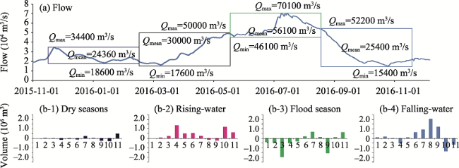
Figure 7 Seasonal variations in (a) flow and (b1-4) volume of sand at a 12.5-m depth for the Jingjiang point bar and Fubei channel. Positive values represent siltation and negative values represent scouring
During the falling-water season from August to November 2015, the Jingjiang point bar was scoured, whereas the overall tendency was depositional. During the periods from August to November 2015 and August to November 2016, the number of days during which the flow decreased from 45,000 m3/s to 25,000 m3/s were 68 and 21, respectively. The water flow in the dry season in 2015 was significantly lower than that in 2016. Correspondingly, the 12.5-m shipping channel of the Fubei channel was mainly scoured in the dry season in 2015, whereas it was mainly deposited in the dry season in 2016.
3.1.4 Sediment volume variation at the Jingjiang point bar and Shuangjian shoal mid- channel bar
During July 2014 to February 2017, there were only minor variations in the overall stable trend in sediment volume at the Jingjiang point bar. A channel depth control datum was taken as a reference, where the sediment volume with the channel depth greater than 12.5 m was approximately 4450 × 104-4790 × 104 m3, with a mean value of 4550 × 104 m3 (Figure 8a). In contrast, the volume at the Shuangjian shoal mid-channel bar steadily decreased at a rate of 310 × 104 m3 during July 2014 to February 2017, before stabilizing at a value of approximately 90 × 104 m3 during August 2016 to February 2017 (Figure 8b). From May to August 2015, the erosion volume at the Jingjiang point bar was 41 × 104 m3, whereas that at the Shuangjian shoal mid-channel bar was 72 × 104 m3; the volume of the corresponding erosion and deposition (VCED) in the Fubei channel at a depth of 12.5 m was 254 × 104 m3. From May to August 2016, the erosion volume at the Jingjiang point bar was 256 × 104 m3, whereas that at the Shuangjian shoal mid-channel bar was 121 × 104 m3; the VCED in the Fubei channel at a depth of 12.5 m was 360 × 104 m3. Thus, both the Jingjiang point bar and the Shuangjian shoal mid-channel bar were scoured during the flood season (Figure 8c), while erosion and deposition occurred in the Fubei channel at a depth of 12.5 m (Figure 8d).
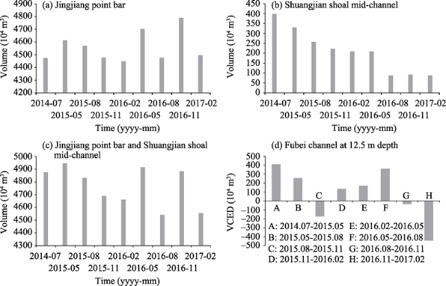
Figure 8 Variations in sediment volumes at the (a) Jingjiang bar, and (b) Shuangjian shoal mid-channel bar

3.2 Relationships among flow, erosion/deposition in point and mid-channel bars, and the Fubei channel

3.2.1 Conditions in the Fubei channel
In August 2016, the length of the Fubei channel at a depth of 12.5 m was 1737 m, with an increase of 730 m in its length recorded in November 2015. In the 2016 silting at the tail of the Jingjiang point bar, a shallow beach with a water depth of less than 12.5 m crossed the channel. Thus, the degree of obstruction to navigation was large during this period, as the navigational water depth at Liuzhu port (the entrance to the Fubei channel) was <12.5 m. During the same period, the length of the Fubei channel at depths of <12.5 m was 2800 m, with an increase of 387 m in its length recorded in November 2015. During a high-water year, the erosion volumes at the point bars of the Jingjiang point bar and the Shuangjian shoal mid-channel bar were higher than those in the middle- and low-water years. This shows that the significant obstruction in navigation was mainly related to the values of water flow in the Fubei channel in 2016, as the minimum water depth remained unchanged (Table 2). Due to the downstream movement of the Jingjiang point bar, the 12.5-m depth contour was disconnected from Xiashi and Qinglong during the period between November 2015 and August 2016. In November 2015 and in August 2016, at the entrance of the channel, the channel lengths at depths of <12.5 m were 6725 m and 9400 m, respectively. The length of channels obstructing navigation in this period increased by 2646 m, and the minimum water depth decreased by 1.1 m; the channel’s depth was less than 12.5 m, and its length was 9139 m. The length of the reaches in the Fubei channel with insufficient water depth was 9130 m in February 2017, an increase of 632 m from that in November 2016 (Table 2).
Table 2 Channel lengths at depths of <12.5 m and minimum depths in the Fubei channel over time (m)
Time Fuzuo channel Fubei channel entrance Fubei channel mid-section Total length
Length Minimum depth Length Minimum depth Length Minimum depth
2012.12 1544 12.2 6856 8.1 4765 5.6 13165
2013.07 0 - 6373 9.5 4737 6.1 11110
2014.07 0 - 6724 10.8 4604 5.8 11328
2015.05 532 12.3 3162 10.8 6893 7.8 10587
2015.08 1015 12.1 2750 10.6 6641 7.1 10406
2015.11 1007 11.9 2413 11.3 6754 7.1 10174
2016.02 1426 11.4 2553 10.3 6754 8.8 10733
2016.05 1198 11.7 2080 10.8 6710 7.5 9988
2016.08 1737 9.3 2800 11.3 9400 6.0 13937
2016.11 1675 8.1 2500 11.5 8498 6.0 12673
2017.02 1350 9.5 2985 11.5 9130 8.0 13465

Note: Regarding the side boundary of the 12.5 m shipping channel as the border line, we checked the length that had a water depth shallower and deeper than 12.5 m in the shipping channel, which was less than 260 m. Thus, the length of obstructed navigation was the sum of both (i.e., minimum depth less than 12.5 m and channel lengths less than 260 m.

3.2.2 Quantitative relationships
Figure 9 shows the relationships of the dredging volume in the 12.5-m shipping channel in the Fubei channel since 2012 with the Jingjiang point bar, the Shuangjian shoal mid-channel bar, and with the flow characteristics over different periods, respectively. In the dry season, the rising-water periods, and the flood season, siltation occurred in the channel at a depth of 12.5 m. The amount of deposition was the largest in the flood season, whereas erosion occurred in the falling-water stage. When the Jingjiang point bar and the Shuangjian shoal mid-channel bar were scoured, siltation occurred in the Fubei channel at a depth of 12.5 m (Figures 9a-9c). As recorded at the Datong hydrometric station, the amount of siltation increased with the increasing number of days at which Q (volumetric flow rate) was greater than 40,000 m3/s (Figure 9d).
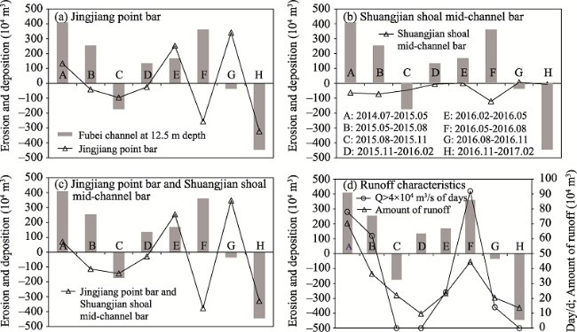
Figure 9 Relationships between erosion and deposition in the Fubei channel at a depth of 12.5 m in the (a) Jingjiang point bar; (b) Shuangjian shoal mid-channel bar; (c) Jingjiang point bar and Shuangjian shoal mid-channel bar; (d) flow characteristics over different time periods. Positive values represent siltation and negative values represent scouring
Taking Datong station as an example, the average annual sediment concentration during 2003-2016 decreased by approximately 70% of the totals during 1955-2002 (Yang et al., 2018; Guo et al., 2019). In this reach, the sediment involved in bed-forming processes was mostly bed load, the transport of which was mainly controlled by factors such as the magnitude of the water discharge and related processes within the year. Therefore, in an analysis of the quantity of sediment scouring and the siltation in the navigational channel, parameters that provide the sediment supply should be considered, such as the erosion of the point and side bars and the hydrograph of the flow.
Using these parameters, the following is obtained:
(1) The relationship between the amount of erosion and deposition in the channel at the point bars and mid-channel bars is as follows:
Vtrough = -0.52 × VJingjiang point bar + 197.36 R = 0.86 (P < 0.10)
Vtrough = -2.31 × VShuangjian shoal + 88.29 R = 0.87 (P < 0.10)
Vtrough = -0.44 × (VJingjiang point bar + VShuangjian shoal) + 178.30 R = 0.88 (P < 0.10)
where Vtrough is the amount of erosion and deposition (104 m3/y) in the Fubei channel, VJingjiang point bar and VShuangjian shoal are the sediment volumes at the Jingjiang point bar and Shuangjian shoal mid-channel bar, respectively (104 m3/y), and R is the correlation coefficient. For example, erosion at the Jingjiang point bar and Shuangjian shoal mid-channel bar causes siltation in the Fubei channel. Based on the fitting parameters of Eq. 4, approximately 44% of the bed load from the upstream reaches was deposited within the 12.5-m deep Fubei channel.
(2) When the water discharge at the Datong station was 40,000 m3/s, the tidal current limit moved downstream of the Fujiangsha reach. This water discharge was the critical flow for erosion and cutting at the end of the reaches. Based on the variation characteristics of the end of the reaches in the Jingjiang point bar and their relation to water discharge, when the water discharge at Datong station was higher than 40,000 m3/s, the end of the beaches in the Jingjiang point bar was cut (Yang et al., 2012; Wang et al., 2020). At this time, the transport of the bed load was active, and it flowed into the Fujiangsha reach. When the upstream water flow was higher than 40,000 m3/s, it was essential to focus on the duration of the discharge and its total volume from the perspective of water dynamics. The relationship between the amount of erosion and deposition in the channel and the flow characteristic parameters is as follows:
Vtrough = 0.081 × Vflow -40.61 R = 0.73 (P < 0.10),
Vtrough = 3.25 × Vdays + 51.53 R = 0.82 (P < 0.10),
where Vflow is the annual flow (1011 m3/yr) at the Datong hydrometric station and Vdays is the number of days per year when Q > 40,000 m3/s. In the flood season, when the amount of flow increased by 1000 × 108 m3, the amount of siltation in the Fubei channel increased by 81 × 104 m3. When the number of days with Q > 40,000 m3/s increased by 10 days, the amount of siltation in the channel increased by 32.5 × 10⁴ m3.
(3) The relationship between the amount of erosion and deposition in the channel and the parameters of the point and mid-channel bars and flow characteristics is as follows:
Vtrough=-0.348×(VJingjiang point bar VShuangjian shoal)+0.033×Vflow+93.82 R=0.91(P<0.05)
Overall, for each 100 × 104 m3 of sediment eroded at the point and mid-channel bars, approximately 34.8 × 10⁴ m3 were deposited in the Fubei channel. When the flow increased by 1000 × 108 m3, the amount of siltation increased by 33 × 104 m3. Erosion at the Jingjiang point bar mostly occurred in the flood season, especially in the years with high annual precipitation. In these cases, when the flow increased by 1000 × 108 m3, the amount of erosion at the Jingjiang point bar and Shuangjian shoal mid-channel bar increased by 138 × 104 m3. Converting to the same flow process, when the flow increased by 1000 × 108 m3, the amount of siltation in the channel caused by variation in the amount of erosion of the Jingjiang point bar and Shuangjian shoal mid-channel bar was 48 × 104 m3; and the amount of siltation caused by changes in flow characteristics was 33 × 104 m3. Based on Eqs. 4, 5, and 7, the increased erosion at the point bars and central bars and the increased sediment from the river flow during the flood season were responsible for 59.3% and 40.7% of the siltation in the 12.5-m shipping channel of the Fubei channel, respectively.

4 Conclusions

Ongoing economic and social development in the Yangtze River Basin has resulted in the extension of deep-water channels from the estuary to the upstream tidal reaches. However, the complex shoals and flow regimes in tidal reaches make the navigation channel unstable. The Fujiangsha reach in the tidal Yangtze River has many braided channels that require increased maintenance. In this study, the variations in flow, erosion, and deposition in Fujiangsha reach were analyzed, leading to the following conclusions:
(1) After the onset of water storage in the Three Gorges Dam, channels in the Fujiangsha were impacted by erosion, levels of which initially increased and then decreased. Overall, 83.7% of the erosion was concentrated in channels with a depth greater than 10 m, which favored improvements in channel conditions.
(2) According to the relationship between the flow diversion ratio and flow rate, the split ratio of the Funan and Fubei channels decreased with increased water flow (tending to branch in the dry season); whereas the split ratio of the Fubei channel increased with increased water flow (tending to branch in the flood season). The flow diversion ratio, suspended sediment diversion ratio, and bed-load sediment distribution ratio varied for each channel. The Fubei channel was the main watercourse for the transportation of bed-load sediments.
(3) The evolution of the Jingjiang point bar was characterized by a periodic deposition-erosion-deposition sequence, with further erosion occurring on the Shuangjian shoal mid-channel bar. Approximately 44 × 104 m3 of each 100 × 104 m3 of sediment that was eroded from these features were deposited in the 12.5-m deep Fubei channel. The relative weights of the effects of increased erosion from the Jingjiang point bar and the Shuangjian shoal mid-channel bar, and from the flow during flood seasons, on the amount of siltation in the Fubei channe were 59.3% and 40.7%, respectively.
The results of this study successfully established quantitative relationships between erosion and deposition in the Fubei channel, and between variable erosional/depositional patterns on the point and mid-channel bars. These results provide support for the improvement, dredging, and maintenance of the channels of lower Yangtze River reaches that are affected by fluctuating tidal zones and upstream impoundments. These results also serve as a model for the management of similar rivers.
[1]
Changjiang Water Resources Commission of the Ministry of Water Resources (CWRC-MWR), 2016. Changjiang Sediment Bulletin. Wuhan: Changjiang Press. (in Chinese)

[2]
Changjiang Water Resources Commission of the Ministry of Water Resources (CWRC-MWR), 2017. Changjiang Sediment Bulletin. Wuhan: Changjiang Press. (in Chinese)

[3]
Chen Xiqing, Wang Xiaoli, Zhang Erfeng, 2003. Water discharge changes of the Changjiang River downstream Datong during dry season. Journal of Geographical Sciences, 13(3): 355-362.

DOI

[4]
Chen Yongping, Li Jiangxia, Wu Zhigang et al., 2016. Dynamic analysis of riverbed evolution: Chengtong reach of Yangtze Estuary. Journal of Coastal Research, 75(Suppl.1): 203-207.

DOI

[5]
Dai Zhijun, Liu James T, 2013. Impacts of large dams on downstream fluvial sedimentation: An example of the Three Gorges Dam (TGD) on the Changjiang (Yangtze River). Journal of Hydrology, 480(4): 10-18.

DOI

[6]
Dai Zhijun, Fagherazzi Sergio, Mei Xuefei et al., 2016. Decline in suspended sediment concentration delivered by the Changjiang (Yangtze) River into the East China Sea between 1956 and 2013. Geomorphology, 268: 123-132.

DOI

[7]
Dou Guoren, Dong Fengwu, Dou Xiping, 1995. Sediment transport capacity of tidal currents and waves. Chinese Science Bulletin, 40(13): 1096-1096.

[8]
Han Jianqiao, Zhang Wei, Yuan Jing et al., 2018. Channel evolution under changing hydrological regimes in anabranching reaches downstream of the Three Gorges Dam. Frontiers of Earth Science, 12(3): 640-648.

DOI

[9]
Gao Youhua, Gan Beilin, Hou Weiguo et al., 2009. Application of different verification methods for sediment-laden capacity formulae in middle and lower Yangtze River. Journal of Yangtze River Scientific Research Institute, 26(2): 14-17. (in Chinese)

[10]
Guo Leicheng, Su Ni, Townend Ian et al., 2019. From the headwater to the delta: A synthesis of the basin-scale sediment load regime in the Changjiang River. Earth-Science Reviews, 197: 102900.

DOI

[11]
Jin Zhenyu, 2018. Caution for protection in structure regulation works of Fujiangsha waterway. Prot Engineering Technology, 55(4): 87-91. (in Chinese)

[12]
Li Dong, Leng Yuefei, 2017. Maintenance analysis of 12.5 m deep-water channel in Fujiangsha reach section of the Lower Reaches of the Yangtze River. China Water Transport, (2): 68-73.

[13]
Liu Gaofeng., Zhu Jianrong., Wang Yuanye et al., 2011. Tripod measured residual currents and sediment flux: Impacts on the silting of the deepwater navigation channel in the Changjiang Estuary. Estuarine Coastal & Shelf Science, 93(3): 192-201.

[14]
Liu Hongchun, Zhang Wei, Li Wenquan et al., 2013. Evolution characteristics of the left beach of Dongliu waterway and its effect on waterway condition. Port & Waterway Engineering, 482(8): 110-114. (in Chinese)

[15]
Liu Lin, Huang Chengtao, Li Ming et al., 2014. Periodic evolution mechanism of staggered beach in typical straight reach of the middle Yangtze River. Journal of Basic Science and Engineering, 22(3): 445-456. (in Chinese)

[16]
Luo Xiangxin, Yang Shilun, Zhang Jing, 2012. The impact of the Three Gorges Dam on the downstream distribution and texture of sediments along the middle and lower Yangtze River (Changjiang) and its estuary, and subsequent sediment dispersal in the East China Sea. Geomorphology, 179(1): 126-140.

DOI

[17]
Noh Joonwoo, Lee Sangjin, Kim Ji-Sung et al., 2012. Numerical modeling of flow and scouring around a cofferdam. Journal of Hydro-environment Research, 6(4): 299-309.

DOI

[18]
Song Chengcheng, Sun Xiaojing, Wang Jun et al., 2015. Spatio-temporal characteristics and causes of changes in erosion-accretion in the Yangtze (Changjiang) submerged delta from 1982 to 2010. Journal of Geographical Sciences, 25(8): 899-916.

DOI

[19]
Wang Jian, Bai Shibao, Liu Ping et al., 2009. Channel sedimentation and erosion on the Jiangsu reach of the Yangtze River during the last 44 years. Earth Surface Processes and Landforms, 34(12): 1587-1593.

DOI

[20]
Wang Jianjun, Yang Yunping, Shen Xia et al., 2020. Study on the deformation of the point/channel bar of the variable section of the tidal current limit of Yangtze River and its influence on the scouring and silting of dredged channel. Journal of Basic Science and Engineering, 28(4): 751-762. (in Chinese)

[21]
Wang Zhangqiao, Chen Zhongyuan, Li Maotian et al., 2009. Variations in downstream grain-sizes to interpret sediment transport in the middle-lower Yangtze River, China: A pre-study of Three-Gorges Dam. Geomorphology, 113(3): 217-229.

DOI

[22]
Wen Yuncheng, Xu Hua, Xia Yunfeng et al., 2018. Study on recent sedimentation cause of Xingang operation zone of Jingjiang port in lower Yangtze River. Yangtze River, 49(Suppl.1): 6-10. (in Chinese)

[23]
Yang Yunping, Deng Jinyun, Zhang Mingjin et al., 2015. The synchronicity and difference in the change of suspended sediment concentration in the Yangtze River Estuary. Journal of Geographical Sciences, 25(4): 399-416.

DOI

[24]
Yang Yunping, Li Yitian, Han Jianqiao et al., 2012. Variation of tide limit and tidal current limit in Yangtze Estuary and its impact on projects. Journal of Sediment Research, (6): 46-51. (in Chinese)

[25]
Yang Yunping, Li Yitian, Sun Zhaohua et al., 2014. Suspended sediment load in the turbidity maximum zone at the Yangtze River Estuary: The trends and causes. Journal of Geographical Sciences, 24(1): 129-142.

DOI

[26]
Yang Yunping, Zhang Mingjin, Liu Wanli et al., 2019. Relationship between waterway depth and low-flow water levels in reaches below the Three Gorges Dam. Journal of Waterway, Port, Coastal, and Ocean Engineering, 145(1): 04018032.

DOI

[27]
Yang Yunping, Zhang Mingjin, Zhu Lingling et al., 2017. Influence of large reservoir operation on water-levels and flows in reaches below dam: Case study of the Three Gorges Reservoir. Scientific Reports, 7: 15640.

DOI PMID

[28]
Yang Yunping, Zhang Mingjin, Zhu Lingling et al., 2018. Impact of the operation of a large-scale reservoir on downstream river channel geomorphic adjustments: A case study of the Three Gorges. River Research and Applications, 34(10): 1315-1327.

DOI

[29]
Yang Yunping, Zheng Jinhai, Zhang Mingjin et al., 2020. Driving mechanism of Sanyiqiao point bar and shoal evolution in flictution segment of tidal current limit in lower reaches of Yangtze River. Advances in Water Science, 31(4): 502-513. (in Chinese)

[30]
Zhang Wei, Yuan Jing, Han Jianqiao et al., 2016. Impact of the Three Gorges Dam on sediment deposition and erosion in the middle Yangtze River: A case study of the Shashi reach. Hydrology Research, 47(Suppl.1): 175-186.

DOI

[31]
Zheng Shuwei, Cheng Heqin, Shi Shengyu et al., 2018. Impact of anthropogenic drivers on subaqueous topographical change in the Datong to Xuliujing reach of the Yangtze River. Science China Earth Sciences, 61(7): 940-950.

DOI

[32]
Zheng Shuwei, Cheng Heqin, Zhou Quanping et al., 2016. Morphology and mechanism of the very large dunes in the tidal reach of the Yangtze River, China. Continental Shelf Research, 139: 54-61.

DOI

Outlines

/