Special Issue: Fluvial and Geomorphological Features

Flood assessment and early warning of the reoccurrence of river blockage at the Baige landslide

  • GAO Yunjian , 1 ,
  • ZHAO Siyuan , 1, * ,
  • DENG Jianhui 1 ,
  • YU Zhiqiu 1 ,
  • RAHMAN Mahfuzur 2
Expand
  • 1. State Key Laboratory of Hydraulics and Mountain River Engineering, College of Water Resource and Hydropower, Sichuan University, Chengdu 610065, China
  • 2. Key Lab of Mountain Hazards and Surface Processes, Institute of Mountain Hazards and Environment, CAS, Chengdu 610041, China
*Zhao Siyuan (1990-), Assistant Professor, specialized in mechanism and mitigation of geo-hazards. E-mail:

Gao Yunjian (1991-), PhD Candidate, specialized in geological engineering and geological hazards. E-mail:

Received date: 2020-09-15

  Accepted date: 2021-05-27

  Online published: 2022-01-25

Supported by

The Second Tibetan Plateau Scientific Expedition and Research Program(2019QZKK0905)

National Key R&D Program of China(2018YFC15050004)

National Natural Science Foundation Projects(42007248)

Copyright

© 2021 Science Press Springer-Verlag

Abstract

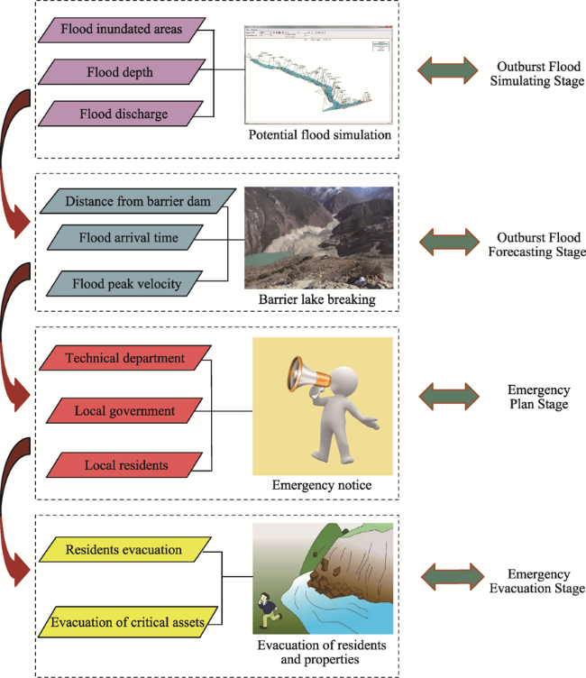
On 10th Oct. and 3rd Nov. 2018, two successive landslides occurred in the Jinsha River catchment at Baige Village, Tibet Autonomous Region, China. The landslides blocked the major river and formed the barrier lake, which finally caused the huge flood disaster loss. The hillslope at Baige landslide site has been still deforming after the 2018 slidings, which is likely to fail and block the Jinsha River again in the future. Therefore the investigation of 2018 flood disaster at the Baige landslide is of a great significance to provide a classic case for flood assessment and early warning for the future disaster. The detailed survey revealed that the outstanding inundations induced bank collapse disasters upstream the Baige landslide dams, and the field investigations and hydrological simulation suggested that the downstream of the Baige landslide were seriously flooded due to the two periods of the outburst floods. On these bases, the early warning process of potential outburst floods at the Baige landslide was advised, which contains four stages: Outburst Flood Simulating Stage, Outburst Flood Forecasting Stage, Emergency Plan and Emergency Evacuation Stage. The study offers a conceptual model for the mitigation of landslides and flood disasters in the high-relief mountainous region in Tibet.

Cite this article

GAO Yunjian , ZHAO Siyuan , DENG Jianhui , YU Zhiqiu , RAHMAN Mahfuzur . Flood assessment and early warning of the reoccurrence of river blockage at the Baige landslide[J]. Journal of Geographical Sciences, 2021 , 31(11) : 1694 -1712 . DOI: 10.1007/s11442-021-1918-9

1 Introduction

The southeastern Qinghai-Tibet Plateau, which is characterized by distinct topographic relief, has become one of the most vulnerable areas in China for landslide-damming events and outburst flood disaster (Robin et al., 2006; Wang et al., 2015; Damodar et al., 2016; Xu et al., 2016; Shi et al., 2017*The steep bank slope incised by major rivers in mountainous region intensifies the topographic conditions of the landslide dam event (Adam et al., 2016; Liao et al., 2018; Zhou et al., 2020*As a strongly constructed fractured zone, the suture belt of the Qinghai-Tibet Plateau critically dominates the developments of the landslide dam events (Chen et al., 2013; Liang et al., 2018*Increasing number of catastrophic landslide-damming events imply that outburst floods triggered by dam breach cannot be ignored in that it will induce wide range, long duration, and severe damage losses (Arpit et al., 2013; Emmer et al., 2014; Birendra et al., 2019).
The landslide dams are mainly composed of rock blocks and debris that deposits in the valley and blocks rivers commonly. It has been revealed that 44%-51% of landslide dams burst in one week, 59%-71% burst in one month, and 83% burst in six months after the blockage (Schuster and Costa, 1986; Peng and Zhang, 2012*As a result, they were susceptible to dam breached and trigger catastrophic outburst floods. From the perspective of flood disaster warning and forecasting, a better understanding of landslide-dammed lakes is required as these lakes sometime initiate destructive outburst floods (Robin and John, 2006; Rivas et al., 2015; Mihu et al., 2016; Dušan et al., 2018; Wang et al., 2019; Zhao et al., 2019*Floods induced by barrier lake outbursts can travel downstream for dozens or hundreds of kilometers in distance that causes widespread damages and losses to residents and properties (Christian et al., 2002; Dal et al., 2013; Yang et al., 2013; Abdul et al., 2018*Several catastrophic landslide-dammed lake events occurred at the southeastern Qinghai-Tibet Plateau has been reported (Zhu et al., 2002; Xu et al., 2012; Shi et al., 2017; Chen et al., 2018; Zhao et al., 2018*In particular, a historic catastrophic landslide occurred on the mountain peak upstream of the Zhamulong channel and blocked the Yigong River, forming the Yigong Lake which still exists at present (Shang et al., 2003; Hu et al., 2015; Zhou et al., 2015*On 9th Apr., 2000, a larger dammed lake was formed and a more serious flood disaster was produced by the secondary Yigong landslide. Substantial losses have been reported for the 2000 Yigong landslide, including 1765 deaths and the destruction of more than 5500 houses (Stephen and Keith, 2011; Xu et al., 2012; Keith and Stephen, 2015; Kang et al., 2016).
Given that the frequent occurrences of outburst floods in mountainous area, the survey and warning of outburst floods has become a critical task for flood prevention and mitigation (Robin et al., 2006; Yang et al., 2013; Adam et al., 2016; Liao et al., 2018; Wang et al., 2018*Based on the field investigation and simulation work, the assessments of flood disaster losses can be evaluated, and the warning and forecasting of the re-outburst floods can be effectively implemented (Mohsin et al., 2013; Jeremy et al., 2019).
On 10th Oct. and 3rd Nov. 2018, two successive landslides (the “10.10” and “11.3” landslides thereafter) occurred in Baige Village, Boluo Town, Jiangda County, Tibet Autonomous Region (Xu et al., 2018; Liang et al., 2019; Ouyang et al., 2019; Yang et al., 2019; Zhang et al., 2019a; Zhang et al., 2019b*The two landslides blocked the Jinsha River and formed two periods of barrier lakes, and the outburst flood caused serious property losses in the upstream and downstream of the barrier dam (Liang et al., 2019; Yang et al., 2019*Some scholars have simulated the different scenarios of the potential river blockage by a future landslide, and analyzed the downstream flood discharge process (Fan et al., 2019; Zhang et al., 2019*Some portions of the source area of the Baige landslide have been continuously deforming, which is likely to slide down and block the river again (Deng et al., 2019; Fan et al., 2019*Thus, the early warning of the potential outburst flood after the river blockage and dam breach is of particular importance. In this paper, the barrier lake formed by the Baige landslide provided an example to study outburst flood disaster and warning process. The outburst flood disaster and loss assessment were studied by field and simulation (HEC-RAS 5.0.4*A warning process of potential outburst floods was proposed based on the flood events. The conclusions we present were helpful measures for forecasting the risk of dam-break and for disaster prevention and mitigation.

2 Overview of the Baige landslide

The Baige landslide (31.08°N, 98.7°E) occurred in the Jinsha River, 20 km downstream of Boluo Town, Jiangda County, Tibet Autonomous Region (Figure 1*The Baige landslide occurred twice, formed barrier dams, and blocked the Jinsha River on 10th Oct. and 3rd Nov. 2018.
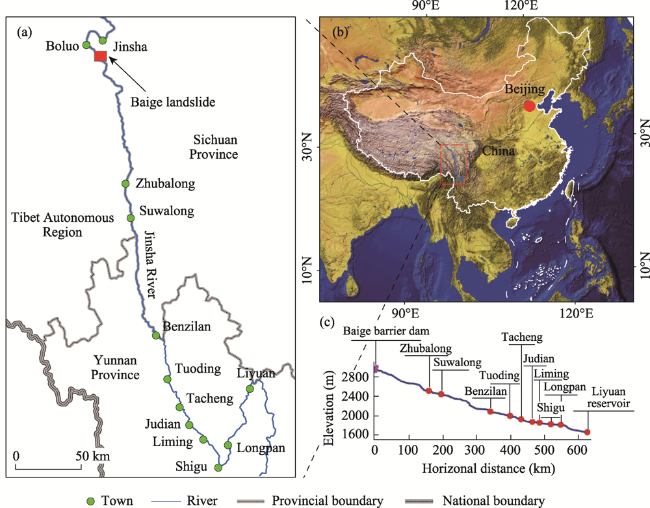
Figure 1 Geographical location (a. Submerged area of upper and lower reaches of the Baige landslide dam; b. Regional location of the study area; c. Longitudinal profile of the main channel downstream of the Baige landslide dam)
The dam breach of the landslide induced a serious outburst flood which affected the river segment within ~670 km downstream of the Baige landslide. The Jinsha River was blocked by the first landslide (10th Oct. 2018) that generated debris with a total volume of ~18.6×10⁶ m3, a length of ~1200 m, an average width of 143 m, a minimum height of 51 m and a maximum height of 125 m (Figure 2*The body of the second landslide (3rd Nov. 2018) blocked the Jinsha River again, and the barrier lake was formed and existed for 22 days until the dam breach on 25th Nov. 2018. This barrier dam had a length of 1005 m, an average width of 143 m, an average thickness of 40 m, an area of 0.206 km2, and a volume of~6.3×10⁶ m3. As shown in Figure 1, the study area is located along the trunk of the Jinsha River. The Baige landslide is located at the site which is ~70 km in the downstream of Jinsha Town and is ~670 km in the upstream of Liyuan Reservoir.
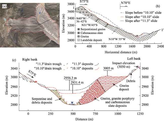
Figure 2 Landslide profile (a. Geomorphic characteristic of the Baige landslide; b. Cross section of the entire Baige landslide (modified from Chen et al*2021); c. Cross section of the Baige landslide deposition)

3 Methods

3.1 Field investigation and data acquisition

Field investigation is crucial for flood assessment, and obtaining the corresponding hydrological and disaster loss data is essential to carrying out effective early warning of potential dam events. We investigated the flood inundated region, bank collapse disaster, and property loss details from Nov. 2018 and Mar. 2019. The field survey on flood disaster was conducted along the segment of the Jinsha River over 400 km downstream of the Baige landslide in Dec. 2018. The contents of the investigations mainly included flood submerged water level, flood arrival time and disaster losses along the river, etc. The data obtained from the field investigation provided a reference for the simulation of the future flood, which is helpful to theoretically support the disaster prevention and mitigation of potential flood disaster.

3.2 Flood disaster simulation

3.2.1 Data preparation

Due to the large-scale and long-distance effects of the barrier lake outburst flood, the simulation method can be practicably applied for early warning of the potential outburst flood. Outburst flood stimulation is crucial for assessing the emergency risk of landslide-dam burst. Based on aerial photograph, digital elevation model (DEM), and some other remote sensing data, information such as location and geometry of the potential downstream flood region could be identified and analyzed. We used ASTER GDEM (resolution = 30 m) of the NASA Terra satellite to quantitatively analyze the topography. Field surveys and hydrographic monitoring were conducted downstream of the barrier dam. The discharge data were obtained from the documentation (Yu et al., 2020*Subsequently, remote sensing data was used for visual observations identifications of land-use type.

3.2.2 HEC-RAS simulation

The HEC-RAS 5.0.4 program, which is developed by Hydrologic Engineering Center (HEC) of the US Army Corps of Engineers, could be used to simulate the flooding upstream and downstream of the barrier lake. The HEC-RAS software allows the manipulation of one and two-dimensional steady flow, unsteady flow, and sediment transport calculations. The HEC-RAS project encompasses several aspects of hydrologic engineering: rainfall-runoff, river hydraulics, reservoir system simulation, flood damage analysis, and real-time river forecasting for reservoir operations.
HEC-RAS program can be applied to effectively calculate the key data of the flood including maximum inundation range, water depth, velocity, etc., which are critical to mitigate the risk of potential outburst flood and to propose the corresponding emergency measures. In this paper, HEC-RAS program was used to simulate flood damage for the lower reach of the Baige landslide along the Jinsha River. As shown in Figure 3, there were three steps required to perform the calculation process: 1) the relevant data for unstable flow simulation was input into HEC-RAS including elevation, cross-section, and Manning coefficient data; 2) the unsteady flow function was applied in the HEC-RAS software to simulate the outburst flood inundated area, and flow depth; 3) the influence of outburst flood regions was analyzed and the dangerous flood water level and hazard losses were assessed. The investigation of the outburst flood regions mainly relied on discharge data from the downstream river segment of the Baige landslide. Based on the results of the flood simulations, we assessed the scope and area of flooding for the different land-use types. The manning coefficient, which determines the velocity of burst output, was adapted from Chow et al*1988) in accordance with different land-use types (Table 1).
Figure 3 Flow chart of flood simulation for potential outburst floods
Table 1 Manning coefficient of land-use types for flood simulation
Parameter Land-use type Value
Manning coefficient Farmland 0.035
Housing land 0.150
Road 0.030
Forest land 0.100
Grassplot 0.030
Alluvial flat 0.025

4 Upstream inundation flood assessment

4.1 Water storage and inundation disaster caused by the “10.10” barrier lake

The “10.10” barrier dam was mainly composed of loose debris, which survived not long and the outburst flood occurred quickly. The water level of the first landslide damming event (“10.10” landslide) was raised from 2880 m to 2931 m, and the total storage capacity reached 180×106 m3. Around 17:30 pm (UTC+8 thereafter) on 12th Oct. 2018 (Zhang et al., 2019a), when the water level reached the highest 2931 m, the natural dam breached and the peak discharge was over 10,000 m3/s. By 22:00 pm on 13th Oct. the Baige barrier dam of Jinsha River has attained a balance of incoming and outgoing storage, and the flow rate reached a steady state.
According to the investigation of the upstream flood area and the height of the barrier dam in the Baige landslide, the backflow with a length of 45 km was formed in the upper reach of the dam. Two towns along the Jinsha River suffered serious flood inundation disaster (Figure 4*The flood disaster caused by the “10.10” damming event was serious around Boluo Town, where the water level rose from 2900 m to 2935 m. Farmland with an area of 0.043 km2 was inundated, and three houses located on the township platform of riverbank (2925-2970 m) collapsed during the inundation. Two villages (Tagong and Caima) between the barrier dam and Boluo Town along the river were seriously flooded. Four houses in Tagong Village were collapsed and the farmland with an area of 0.032 km2 was flooded. One house in Caima Village collapsed, and the nearby farmland was submerged over an area of ~0.065 km2.
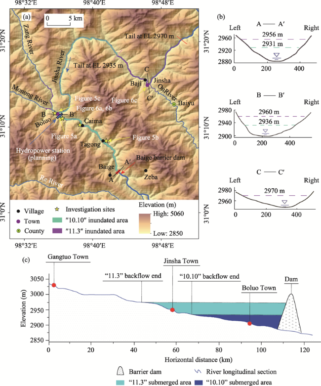
Figure 4 Barrier lakes at different elevations (a. Plan of flood area in upstream of barrier dam; b. Flood level of typical townships upstream of the barrier dam; c. Profiles of flood area in upstream of the barrier dam)

4.2 Riverbank slope disaster induced by inundation of the “10.10” barrier lake

Flood inundation of the “10.10” barrier lake caused substantial bank slope disasters as well, which mainly concentrated in the river segment from the dam to upstream Boluo Town along the Jinsha River. The right bank slope of the river 2.5 km downstream Boluo Town generated cracks on the surface as a result of creep deformation induced by the impoundment (Figure 5a*Farmlands and road facilities were also destructed by intense slope movements as well as by inundation. As the water level of the “10.10” barrier lake declined, a number of small collapse events continuously occurred along the river bank (Figures 5b and 5c*Furthermore, deposits of two paleo-landslides (the Xiaomojiu and Guili landslides) located at 5 km upstream the Baige dam was reactivated to deform valley-wards, which might slide towards the valley bottom in a future rainfall or earthquake event.
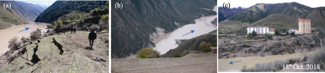
Figure 5 The “10.10” bank slope disaster (a. 5 km downstream of Boluo Town; b. Tagong Village; c. Boluo Town)

4.3 Water storage and flood disaster caused by the “11.3” barrier lake

The river blockage and inundation caused by the second landslide (“11.3” landslide) give rise to higher water level and longer water storage duration compared to the “10.10” barrier lake, although the volume of the “11.3” landslide is rather small. The later “11.3” landslide had blocked the river for 10 days until the dam breach occurred on 13th Nov. The highest water levels in Boluo and Jinsha towns in the submerged area reached 2960 m and 2970 m, respectively (Figure 4a*The depth of the barrier lakes at the two towns were up to 60 m and 26 m, respectively, which were deeper than that of the “10.10” inundation with the depths of 36 m and 0 m. The backwater of the “11.3” barrier lake submerged a 70-km-long river segment upstream the landslide dam with the peak storage capacity of ~500×106 m3. Then the barrier lake was discharged artificially on the morning of 13th Nov. 2018, and the peak flow was up to ~31×103 m3/s (Yu et al., 2020).
The “11.3” barrier lake caused serious inundation disaster in Boluo and Jinsha towns, which induced infrastructure damage and a great number of slope deformations along the 20-km-long river between Boluo Town and the barrier dam. The water levels of submerged area were investigated in detail. The highest water level attained the 9th floor of the highest building of the township government (11 floors in total) in Boluo Town (Figure 6a*Some wall cracks of the main temple were generated during the submergence (Figure 6b), whereas most of the surrounding buildings were destroyed. The school, the hospital, approximately 60 houses of local farmers, were flooded as well as the farmland with an area of 0.13 km2. The backwater of the “11.3” barrier lake reached the river site 15 km upstream Jinsha Town, resulting in severe damages and submergence of over ten houses, several bridges, and the farmland with an area of 0.085 km2 (Figure 6c).
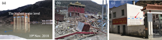
Figure 6 The “11.3” flood disaster (a. Boluo township government building; b. Boluo Temple; c. Jinsha Town)

4.4 Riverbank slope disaster induced by inundation of the “11.3” barrier lake

The water level of the inundated area rose rapidly as a result of river blockage by the two slope failures (the “10.10” and “11.3” landslides) at the Baige hillslope. The “10.10” barrier dam burst in 44 hours, while the “11.3” barrier dam had been surviving for 10 days prior to the dam breach, in which processes the water level dropped significantly. Slope movement is subject to such behavior of water level fluctuation, which reactivated the deposits of two old landslides (the Xiaomojiu and Guili landslides) on the right bank of the Jinsha River in the upper reaches of the Baige landslide dam (Figures 7a and 7b*The sliding distances of the two old landslides were not large, and their deposits still seated on the hillslope before the flood occurred. After the occurrence of the Baige landslide, the seepage force generated by the reservoir impounding and dam breach decreased shear strength of the old landslide deposits, which induced the further deformation of the Xiaomojiu and Guili landslides (Figures 7a and 7b).
The Xiaomojiu landslide with an area of 0.71 km2 and a volume of 12.7×10⁶ m3 was located 5 km upstream the Baige landslide dam, and then slope deformation was initiated by the flood behavior (Figure 7a and Table 2*The relative elevation of the landslide headscarp is ~710 m above riverbed. The rock types of the landslide area were dominated by plagioclase-gneiss and diorite. The tectonic setting of the landslide region is mainly characterized by the Jinsha River fault belt. Its major fault generally strikes NW-SE and is ~1 km away from the two old landslides, which could significantly control the landslide developments. Since the two slope failures of Baige landslide blocked the river twice, the water levels of the two periods of barrier lake were raised and submerged the slope toe of the landslide deposit. After the dam-breaks the water levels of the barrier lakes decreased rapidly and remobilized the deposit slopes. The secondary Xiaomojiu landslide started to deform intensely along the headscarp and sliding surface of the former landslide. The further deformation of the old landslide body continuously developed and created a number of cracks on the slope surface, and the crack width is ~20-30 cm (Figure 7c).
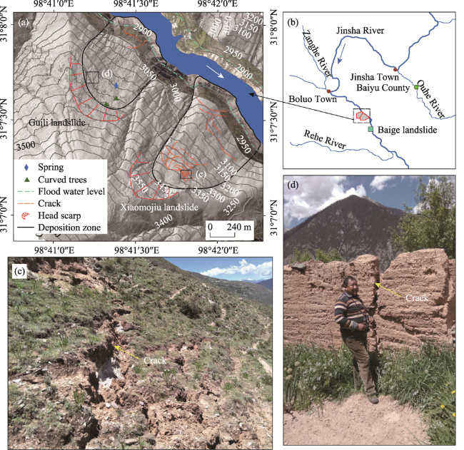
Figure 7 Landslides induced by the fluctuation of water level in barrier lake area
Table 2 Statistics on the basic information of typical landslide deformation induced by barrier lake
Landslide Deposition zone (km2) Volume (×106 m3) Average slope (°) Relative elevation (m)
Xiaomojiu 0.71 12.70 29 710
Guili 0.44 3.20 25 510
The adjacent Guili landslide with an area of 0.44 km2 and a volume of 3.2×10⁶ m3 was located 6.5 km upstream the Baige dam. The relative elevation of the Guili landslide is ~510 m above riverbed. The lithological and tectonic setting of the landslide area are similar to that of the Xiaomojiu landslide. An interview with local people suggested that the Guili landslide formed the outstanding headscarp in an earthquake event in the 1940s. The continuous heavy deformation of the deposit of the former Guili landslide was incipient after the two periods of the dam breaches in Oct. and Nov. 2018. Some new cracks on the old house wall could be observed on the slope surface (Figure 7d), which indicated that the slope had been further deformed in the recent time after the Baige landslide. To sum up, the Xiaomojiu and Guili landslides demonstrated the similar mechanism of slope deformation, which could be attributable to typical reservoir-induced landslides.

5 Downstream flood disaster assessment

5.1 The “10.10” flood disaster

The “10.10” landslide body slid down and dammed the Jinsha River at 22:06 pm on 10th Oct. 2018. The dam materials were mainly composed of heavily weathered rock mass and would be easily eroded (Chen et al., 2021), suggesting a great threat of potential flood disaster for the downstream catchment. Subsequently, the landslide dam was naturally overtopped at 17:30 pm on 12th Oct. 2018 and soon formed a large breach within the dam, which was 800 m in length, 116 m in average width, 53 m in thickness, and 4.9×10⁶ m3 in total volume. The variation of discharge at the dam suggested that the dam breach initiated on 12th Oct. and the discharge peaked at ~10,000 m3/s at 10:00 am on 13th Oct*Yu et al., 2020) (Figure 8a*Only 44 hours after the dam breach, the flooding process ended and the discharge decreased to a steady value of ~950 m3/s (Figure 8a*The flood finally flowed downstream along the river, posing moderately high risks to the residents and properties in hundreds-of-kilometers downstream river segment.
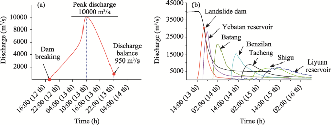
Figure 8 Discharge variation at the dam (a. The “10.10” break flood process of barrier dam; b. The “11.3” break flood process of the downstream dam)

5.2 The “11.3” flood disaster

One more landslide with a volume of 6.29×10⁶ m3 occurred at the Baige site on 3rd Nov. 2018. The scale of this later slope failure was rather small compared to the “10.10” landslide, however, the “11.3” landslide body deposited on the former breach of the “10.10” dam and newly formed a higher barrier dam than before (Deng et al., 2019*The source area of the “11.3” landslide developed on the upper left portion of the former sliding source area (Chen et al., 2021*The “11.3” landslide dam was ~25 m higher than the “10.10” landslide dam, which inundated a barrier lake with the higher water level. In order to mitigate the risk of flood disaster, the “11.3” barrier dam was breached artificially by human through the excavation of a discharge channel after 11 days, which finally brought about the dam break and flood at 7:30 am on 13th Nov. 2018. The highest water level was up to 72 m, and the peak discharge at the dam was ~31,000 m3/s and formed a new breach, which was ~1000 m in length, ~80 m in width, and ~72 m in height. The peak discharges in the flood-affected downstream catchment were also investigated from six hydrological stations (located in Yebatan Village, Batang County, Benzilan Town, Tacheng Town, Shigu Town, and Liyuan Village), which were 28,300 m3/s, 20,900 m3/s, 15,700 m3/s, 9700 m3/s, 7170 m3/s, and 7410 m3/s, respectively (Yu et al., 2020) (Figure 8b*The peak values were 6, 4.4, 3.3, 2, 1.5, and 1.6 times greater than the respective average annual values of discharges at the six stations. It was reported that over 54,000 people in total were affected by the flood disaster along the Jinsha River in the lower reaches of the Baige landslide. Over 41,000 people were urgently evacuated, over 27,000 houses were damaged to various degrees, and totally 33,000-hectares-wide farmlands were affected, one third of which were basically destroyed (Yu et al., 2020*Likewise, transportation facilities including eight bridges in total were heavily damaged in the downstream catchment of the Baige barrier dam (Figure 9), leading to great losses of infrastructures in Tibet and provinces of Sichuan and Yunnan along the Jinsha River.
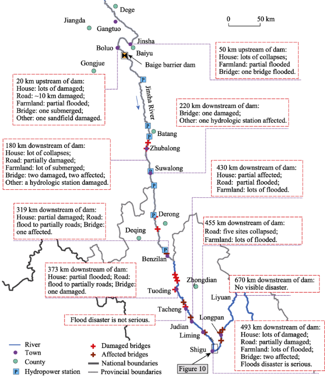
Figure 9 Flood disaster loss in the upstream and downstream of the dam
The maximum flood level plays a substantially significant role in flood hazard assessment. Thus flood-affected region caused by the dam break of the “11.3” landslide was simulated based on the one-dimensional unstable flow in the HEC-RAS 5.0.4 program. The size and discharge parameters of the breach were derived from the deposition of the “11.3” Baige landslide (Figure 4) and the flow data reported by Yu et al*2020*The inundated area and peak flood level could be calculated from the hydrological simulation. On the basis of the field investigation, the simulation results suggested the flood-affected region with an area of ~9.8 km2 in Shigu Town and nearby river segment (Figures 10 and 11), involving the submerged farmland with an area of 5.83 km2, forest land with an area of 0.76 km2, grassplot with an area of 1.38 km2. The houses of local people and roads were submerged and damaged as well even Shigu Town is ~500 km downstream from the Baige landslide dam.
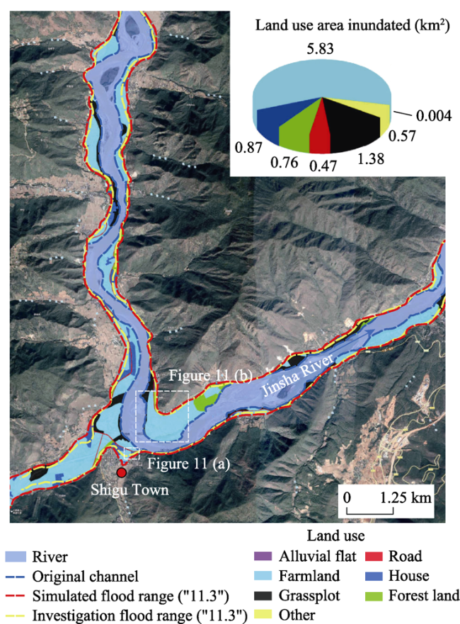
Figure 10 Land type of flood inundated area in Shigu Town
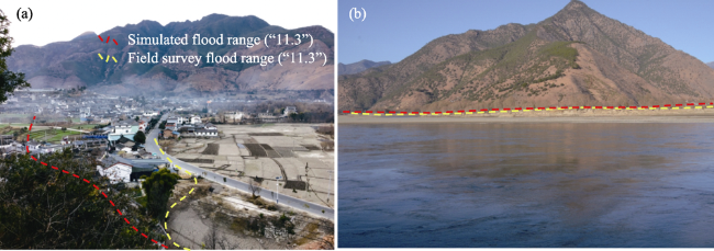
Figure 11 The field investigation area, as shown in Figure 10 (a. Right inundated area of Jinsha River, Shigu Town; b. Left inundated area of Jinsha River, Shigu Town)

6 Early warning of potential outburst floods

The early warning of potential flood is crucial to mitigate the risk and the loss of human beings and their properties, and it should be implemented based on the flooding features in terms of comprehensive investigation including field survey and flood disaster assessment. Then corresponding measurements of risk mitigation could be proposed in light of the early warning. The inundated area and arrival time of flood are critical parameters for disaster prevention and mitigation, which could be calculated by flood simulation via HEC-RAS 5.0.4. The downstream river segment with the length of ~670 km (from the Baige dam to the Liyuan Reservoir) experienced the severe flood disaster and property losses after the dam break of the “11.3” landslide. Shigu Town (belonging to Lijiang City, Yunnan Province) was one of the most affected regions by outburst flood of the “11.3” dam. This study took this region (see Figures 1 and 9 for the location) which was subject to the “11.3” outburst flood as the good case for flood simulation, hazard assessment and early warning (Figures 12 and 13*As shown in Figure 14, the early warning process of potential outburst flood could be mainly divided into following four stages:
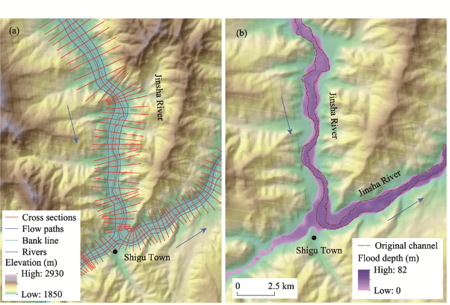
Figure 12 Flood simulation in the Shigu region (a. Section cross selection of simulated reaches; b. Flood inundation elevation)
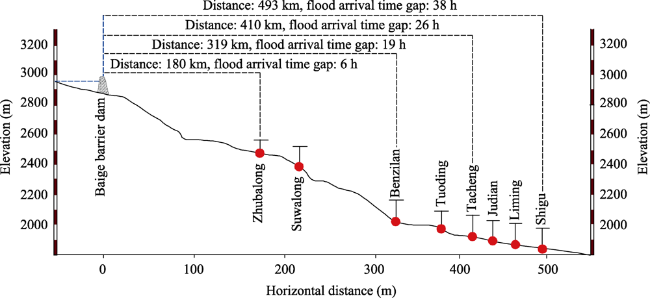
Figure 13 Time of flood arrival in the downstream catchment of the dam
Figure 14 Warning process of outburst floods
(1) Outburst Flood Simulating Stage: The key data containing flood inundated area, flood depth, and peak discharge were simulated in this early stage, as shown in Figure 12. Flood routing along the river can be simulated using HEC-RAS 5.0.4, and the main physical laws used by the program are the conservation of energy in steady flows and the conservation of mass and momentum in unsteady flows. The flood simulation is implemented to calculate the flood inundation elevation and flood depth (Figure 12*The simulation results in such a case demonstrate that flood inundation elevation ranged from 1829 m to 2107 m, and the flood depth was up to 82 m in the region of Shigu Town.
(2) Outburst Flood Forecasting Stage: Flood velocity, flood arrival time and potential inundated area should be assessed as the key data for the flood forecasting process in the downstream of the barrier dam. Flood arrival time determines the window period for the emergency evacuation of residents and properties, and flood potential inundated area determines the affected scope where the emergency evacuation is needed. Taking “11.3” outburst flood as an example, the peak discharge time of the Baige barrier dam occurred at 18:00 pm on 13th Nov. and the flood arrived in Shigu Town at 8:00 am on 15th Nov*38 hours in total*The time interval between the dam breach and the flood arrival depends on the flood velocity, and such time interval provides a crucial period to make the emergency response for disaster mitigations. The assessment results of the “11.3” dam breach illustrated the distance from the dam and arrival time of all the towns in the downstream (Figure 13).
(3) Emergency Plan Stage: In this stage the relevant departments of government issue the announcement of flood threat to inform residents of villages and towns along the risky river segment for urgent evacuation. Government departments at all levels along the river received flood disaster signals and urgently notified residents. Firstly, the risk assessment for the potential flood disaster is conducted by the professional technical department, who would submit the disaster forecasting report to the government; subsequently, the danger signal of flood disaster is released to the residents by the local government through network, telephone, early warning device, etc.
(4) Emergency Evacuating Stage: Organize emergency evacuation of residents and property according to the flood hazard area determined in Outburst Flood Simulating Stage. First of all, the evacuation route should be planned before the disaster, and the resettlement location should be evaluated to prevent unnecessary dangers and losses caused by underestimated flood threat. Secondly, it is noted that the evacuation of residents in the window period in Outburst Flood Forecasting Stage should be the priority, and the preservation of properties can be considered only if the time is sufficient. Finally, government departments and residents should pay attention to the flood danger in the later real disaster and prevent themselves from the secondary injury caused by the insufficient risk estimation.

7 Conclusions

This paper demonstrated an important investigation of the flood assessment of the 2018 catastrophic Baige landslide, and proposed the early warning process for potential outburst flood based on the flood disaster induced by “11.3” dam break. The investigation work in the upstream of the dam mainly included flood inundation process, bank collapse disaster, and the downstream catchment containing flood inundated area, flood-induced loss, and flood flow process. Furthermore, the early warning process and emergency response to outburst flood was proposed on the basis of simulation of the Baige outburst flood. Thus, the following conclusions can be drawn.
(1) The two landslides in Oct. and Nov. 2018 blocked the trunk of Jinsha River twice for 44 hours and 10 days, respectively. Four villages in the upper reaches of the barrier dam were flooded, and two large bank slope movements with severe deformation developed after the inundation and flooding (Xiaomojiu landslide and Guili landslide*The upstream backflow distances of the two periods of barrier lakes were 47 km and 68 km, respectively.
(2) The two outburst floods induced by the Baige landslide affected 11 towns in downstream, where the flood damaged 16 bridges, large areas of farmland, many houses, and some other infrastructures. The flood simulation of the “11.3” dam breach via HEC-RAS illustrated that the inundated area was up to 11 km2 in Shigu Town, which indicated that the dam break originated from the “11.3” landslide resulted in a much greater risk and threat than that of the “10.10” flood according to the flood inundated area, flood discharge, and flood disaster severity.
(3) Hydrological simulation on “11.3” landslide-induced flood disaster via HEC-RAS provides a good case to propose the early warning of a potential outburst flood. The early warning process could be mainly divided into following four stages: Outburst Flood Simulating Stage, Outburst Flood Forecasting Stage, Emergency Plan Stage and Emergency Evacuation Stage. This study examined the conceptual model that would be helpful for the mitigation and prevention of flood disaster caused by landslide-induced river blockage.
[1]
Abdul Hakeem K, Abirami S, Rao V V et al., 2018. Updated inventory of glacial lakes in Teesta Basin using remote sensing data for use in GLOF risk assessment. Journal of the Indian Society of Remote Sensing, 46(3): 463-470.

DOI

[2]
Adam E, Jan K, Martin M et al., 2016. 882 lakes of the Cordillera Blanca: An inventory, classification, evolution, and assessment of susceptibility to outburst floods. Catena, 147: 269-279.4

DOI

[3]
Alin M P, Andrei A, Ionut C N et al., 2016. Using GPR for assessing the volume of sediments from the largest natural dam lake of the Eastern Carpathians: Cuejdel Lake, Romania. Environmental Earth Sciences, 710 (75): 1-13.

[4]
Arpit A, Sanjay K J, Anil K et al., 2013. Glacial lake outburst flood risk assessment using combined approaches of remote sensing, GIS and dam break modeling. Geomatics, Natural Hazards and Risk, 7(1): 18-36.

[5]
Birendra B, Arun B S, Lokap R, 2019. Glacial lake outburst floods in the Sagarmatha region. Mountain research and development, 27(4): 336-344.

DOI

[6]
Chen F, Gao Y J, Zhao S Y et al., 2021. Kinematic process and mechanism of the two slope failures at Baige Village in the upper reaches of the Jinsha River, China. Bulletin of Engineering Geology and the Environment, 80(5): 3475-3493.

DOI

[7]
Chen J, Dai F C, Lv T G et al., 2013. Holocene landslide-dammed lake deposits in the upper Jinsha River, SE Tibetan Plateau and their ages. Quaternary International, 298: 107-113.

DOI

[8]
Chen J, Zhou W D, Cui Z J et al., 2018. Formation process of a larCge paleo landslide-dammed lake at Xuelongnang in the upper Jinsha River, SE Tibetan Plateau: Constraints from OSL and 14C dating. Landslides, 15: 2399-2412.

DOI

[9]
Chen K T, Wu J H, 2018. Simulating the failure process of the Xinmo landslide using discontinuous deformation analysis. Engineering Geology, 239: 269-281.

DOI

[10]
Chow V T, Maidment D R, Mays L W, 1988. Applied Hydrology. New York: McGraw-Hill.

[11]
Christian H, Andreas K, Wilfried H et al., 2002. Remote sensing based assessment of hazards from glacier lake outbursts: A case study in the Swiss Alps. Canadian Geotechnical Journal, 39: 316-330.

DOI

[12]
Dal Sasso S F, Sole A, Pascale S et al., 2014. Assessment methodology for the prediction of landslide dam hazard. Natural Hazards and Earth System Sciences, 14: 557-567.

[13]
Damodar L, Takanobu S, Teiji W et al., 2014. Assessment of glacial lake development and prospects of outburst susceptibility: Chamlang South Glacier, eastern Nepal Himalaya. Geomatics, Natural Hazards and Risk, 7(1): 403-423.

DOI

[14]
Deng J H, Gao Y J, Yu Z Q et al., 2019. Analysis on the formation mechanism and process of Baige landslides damming the upper reach of Jinsha River, China. Advanced Engineering Sciences, 51(1): 9-16. (in Chinese)

[15]
Dušan P, Dragoljub B, Jelena R, 2018. Assessment of historical flood risk to the groundwater regime: Case study of the Kolubara Coal basin, Serbia. Water, 588(10): 1-22.

[16]
Emmer A, Vilímek V, 2014. New method for assessing the susceptibility of glacial lakes to outburst floods in the Cordillera Blanca, Peru. Hydrology and Earth System Sciences, 18: 3461-3479.

DOI

[17]
Fan X M, Xu Q, Andres A R et al., 2019. Successive landsliding and damming of the Jinsha River in eastern Tibet, China: Prime investigation, early warning, and emergency response. Landslides, 16: 1003-1020.

DOI

[18]
Hu M J, Pan H L, Zhu C Q et al., 2015. High-speed ring shear tests to study the motion and acceleration processes of the Yiong landslide. Journal of Mountain Science, 12(6): 1534-1541.

DOI

[19]
Jeremy D B, Wolfgang S, Basanta R A et al., 2019. Performance of models for flash flood warning and hazard assessment: The 2015 Kali Gandaki landslide dam breach in Nepal. Mountain Research and Development, 37(1): 5-15.

DOI

[20]
Kang C, Chan D V, Su F H et al., 2017. Runout and entrainment analysis of an extremely large rock avalanche: A case study of Yigong, Tibet, China. Landslides, 14: 123-139.

DOI

[21]
Keith B D, Stephen G E, 2015. The 2000 Yigong landslide (Tibetan Plateau), rockslide-dammed lake and outburst flood: Review, remote sensing analysis, and process modeling. Geomorphology, 246: 377-393.

DOI

[22]
Liang L J, Dai F C, Jiang H C et al., 2018. A preliminary study on the soft-sediment deformation structures in the late Quaternary lacustrine sediments at Tashkorgan, northeastern Pamir, China. Acta Geologica Sinica, 92(4): 1574-1591.

DOI

[23]
Liang G L, Wang Z, Zhang G W et al., 2019. Two huge landslides that took place in quick succession within a month at the same location of Jinsha River. Landslides, 16: 1059-1062.

DOI

[24]
Liao H M, Yang X G, Xu F G et al., 2018. A fuzzy comprehensive method for the risk assessment of a landslide dammed lake. Environmental Earth Sciences, 77: 1-14.

DOI

[25]
Mohsin J B, Muhammad U, Raheel Q, 2013. Landslide dam and subsequent dam-break flood estimation using HEC-RAS model in northern Pakistan. Nature Hazards, 65: 241-254.

DOI

[26]
Ouyang C J, An H C, Zhou S et al., 2019. Insights from the failure and dynamic characteristics of two sequential landslides at Baige village along the Jinsha River, China. Landslides, 16: 1397-1414.

DOI

[27]
Peng S M, Zhang L M, 2012. Breaching parameters of landslide dams. Landslides, 9(1): 13-31.

[28]
Rivas D S, Somos-Valenzuela M A, Hodges B R et al., 2015. Predicting outflow induced by moraine failure in glacial lakes: The Lake Palcacocha case from an uncertainty perspective. Natural Hazards and Earth System Sciences, 15: 1163-1179.

[29]
Robin J M, John J C, 2006. A procedure for making objective preliminary assessments of outburst flood hazard from moraine-dammed lakes in southwestern British Columbia. Nature Hazards, 1-26.

[30]
Schuster R L, Costa J E, 1986. A perspective on landslide dams. In: Schuster R L (ed.). Landslide Dams: Processes, Risk, and Mitigation. American Society of Civil Engineers, Geotechnical Special Publication, 3: 1-20.

[31]
Shang Y J, Yang Z F, Li L H et al., 2003. A super-large landslide in Tibet in 2000: Background, occurrence, disaster, and origin. Geomorphology, 54: 225-243.

DOI

[32]
Shi Z M, Xiong X, Peng M et al., 2017. Risk assessment and mitigation for the Hongshiyan landslide dam triggered by the 2014 Ludian earthquake in Yunnan, China. Landslides, 14: 269-285.

DOI

[33]
Stephen G E, Keith B D, 2011. Characterization of the 2000 Yigong Zangbo River (Tibet) landslide dam and impoundment by remote sensing. Natural and Artificial Rockslide Dams, 543-559.

[34]
Wang S J, Qin D H, Xiao C D, 2015. Moraine-dammed lake distribution and outburst flood risk in the Chinese Himalaya. Journal of Glaciology, 61: 115-126.

DOI

[35]
Wang X, Liu S Y, Guo W Q et al., 2019. Assessment and simulation of glacier lake outburst floods for Longbasaba and Pida lakes, China. Mountain Research and Development, 28(3): 310-317.

DOI

[36]
Wang Y, Lin Q G, Shi P J, 2018. Spatial pattern and influencing factors of landslide casualty events. Journal of Geographical Sciences, 28(3): 259-374.

DOI

[37]
Xu F G, Yang X G, Zhou J W, 2016. Dam-break flood risk assessment and mitigation measures for the Hongshiyan landslide-dammed lake triggered by the 2014 Ludian earthquake. Geomatics, Natural Hazards and Risk, 8(2): 803-821.

DOI

[38]
Xu Q, Shang Y J, Theo V A et al., 2012. Observations from the large, rapid Yigong rock slide-debris avalanche, southeast Tibet. Canadian Geotechnical Journal, 49: 589-606.

DOI

[39]
Xu Q, Zheng G, Li W L et al., 2018. Study on successive landslide damming events of Jinsha River in Baige Village on Octorber 11 and November 3, 2018. Journal of Engineering Geology, 26(6): 1534-1551. (in Chinese)

[40]
Yang S H, Pan Y W, Dong J J et al., 2013. A systematic approach for the assessment of flooding hazard and risk associated with a landslide dam. Nature Hazards, 65: 41-62.

DOI

[41]
Yang W T, Wang Y J, Wang W Q et al., 2019. Retrospective deformation of the Baige landslide using optical remote sensing images. Landslides, 17: 659-668.

DOI

[42]
Yu Z Q, Deng J H, Gao Y J et al., 2020. Analysis on Baige landslide and barrier lake flood disaster in Jinsha River. Journal of Disaster Prevention and Mitigation Engineering, 40(2): 286-292. (in Chinese)

[43]
Zhang L M, Xiao T, He J et al., 2019a. Erosion-based analysis of breaching of Baige landslide dams on the Jinsha River, China, in 2018. Landslides, 16: 1965-1979.

DOI

[44]
Zhang Z, He S M, Liu W et al., 2019b. Source characteristics and dynamics of the October 2018 Baige landslide revealed by broadband seismograms. Landslides, 16: 777-785.

DOI

[45]
Zhao S, Chigira M, Wu X, 2018. Buckling deformations at the 2017 Xinmo landslide site and nearby slopes, Maoxian, Sichuan, China. Engineering Geology, 246, 187-197.

DOI

[46]
Zhao S, Chigira M, Wu X, 2019. Gigantic rockslides induced by fluvial incision in the Diexi area along the eastern margin of the Tibetan Plateau. Geomorphology, 338: 27-42.

DOI

[47]
Zhou J W, Cui P, Hao M H, 2015. Comprehensive analyses of the initiation and entrainment processes of the 2000 Yigong catastrophic landslide in Tibet, China. Landslides, 13: 39-54.

DOI

[48]
Zhou K, Liu B Y, Fan J, 2020. Post-earthquake economic resilience and recovery efficiency in the border areas of the Tibetan Plateau: A case study of areas affected by the Wenchuan Ms 8.0 Earthquake in Sichuan, China in 2008. Journal of Geographical Sciences, 30(8): 1363-1381.

DOI

[49]
Zhu L F, Zhang G R, Yin K L et al., 2002. Risk analysis system of geo-hazard based on GIS technique. Journal of Geographical Sciences, 12(3): 371-376.

DOI

Outlines

/