Special Issue: Fluvial and Geomorphological Features

Substrate damage and recovery after giant clam shell mining at remote coral reefs in the southern South China Sea

  • ZHOU Shengnan , 1, 2, 4 ,
  • SHI Qi , 2, 1, * ,
  • YANG Hongqiang 2, 1, 3 ,
  • ZHANG Xiyang 2, 1 ,
  • LIU Xiaoju 1, 2, 4 ,
  • TAN Fei 1, 2, 4 ,
  • YAN Pin 2, 1
Expand
  • 1. Key Laboratory of Ocean and Marginal Sea Geology, South China Sea Institute of Oceanology, CAS, Guangzhou 510301, China
  • 2. Southern Marine Science and Engineering Guangdong Laboratory (Guangzhou), Guangzhou 511458, China
  • 3. Nansha Marine Ecological and Environmental Research Station, CAS, Sansha 573199, Hainan, China
  • 4. University of Chinese Academy of Sciences, Beijing 100049, China
*Shi Qi (1971‒), PhD and Professor, specialized in coral reef geomorphology and sedimentology. E-mail:

Zhou Shengnan (1993‒), PhD Candidate, specialized in coral reef geomorphology and environment. E-mail:

Received date: 2020-01-04

  Accepted date: 2021-08-12

  Online published: 2022-01-25

Supported by

Key Special Project for Introduced Talents Team of Southern Marine Science and Engineering Guangdong Laboratory(Guangzhou)(GML2019ZD0206)

Key Special Project for Introduced Talents Team of Southern Marine Science and Engineering Guangdong Laboratory(Guangzhou)(GML2019ZD0104)

National Science & Technology Fundamental Resources Investigation Program of China(2018FY100103)

The Strategic Priority Research Program of the Chinese Academy of Sciences(XDA13010103)

Special Support Program for Cultivating High-level Talents in Guangdong Province(2019BT02H594)

National Natural Science Foundation of China(41776128)

National Natural Science Foundation of China(U1901217)

Copyright

© 2021 Science Press Springer-Verlag

Abstract

Giant clam shell mining (GCSM), a unique phenomenon occurring at remote coral reefs in the southern South China Sea (SCS), forms striking scars on the reef flats and damages the reef flat substrate. Through image analyses at three times (2004.02.02, 2014.02.26, and 2019.04.10) and in situ surveys at Ximen Reef, a representative site that has experienced GCSM, we quantified the GCSM-generated substrate damage and the corresponding recovery. GCSM was estimated to have occurred sometime between 2012 and 2014, causing reduction in live coral subarea and formation of micro-relief as trenches and mounds. GCSM-generated damage was restricted to the reef flat. After GCSM, coral and algae subarea increased, and the trenches and mounds tended to be filled and eroded, representing a natural recovery of the substrate. The legal prohibition on human disturbances at the coral reefs contributed to substrate recovery at Ximen Reef. This case also implied that recovery of the other coral reefs that suffered from GCSM is possible.

Cite this article

ZHOU Shengnan , SHI Qi , YANG Hongqiang , ZHANG Xiyang , LIU Xiaoju , TAN Fei , YAN Pin . Substrate damage and recovery after giant clam shell mining at remote coral reefs in the southern South China Sea[J]. Journal of Geographical Sciences, 2021 , 31(11) : 1655 -1674 . DOI: 10.1007/s11442-021-1916-y

1 Introduction

The huge, thick shell of the giant clam (Tridacna gigas) is an important raw material for handicrafts, such as jewelry and other ornaments, with vast markets established in China. Within the past several decades, the demand for giant clam shells has been growing with an increasing demand for giant clam shell crafts. Tanmen, a town in Hainan province, is the center of processing and marketing of giant clam crafts in China. Coral reefs in the South China Sea (SCS) are the major habitat of giant clam, which later became the traditional source. Fishermen had mined an amount of giant clam shells at different coral reefs in the SCS that led to extensive damage to the reefs. In order to protect the marine ecological environment and biological resources, the Chinese government, in 2016, amended laws and strengthened inspections to ban fishing and mining of critical species, including corals and giant clams in the SCS. Since then, giant clam shell mining (GCSM) and giant clam craft sales have essentially vanished.
GCSM usually occurs on the reef flat because most of the shells are buried under sediments. The apparatus used in GCSM is a propeller with a long shaft that extends below the water line from an outboard motor mounted on a boat (Figure S1a and S1c*The propeller is then spun into a reef flat substrate and swung laterally from side to side, stirring up the sediment to loosen the giant clam shells. Then, the buried shells are collected easily through diving and hoisted into a boat (Figure S1d*Generally, several boats mined around the reef flat, and a mothership stayed outside the reef and waited for the shells collected from the boats.
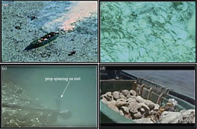
Figure s1 Giant clam shell mining on coral reefs in the South China Sea (from Lee, 2016) (a. a mining boat on a reef flat; b. arc-shaped scars on a satellite image; c. a propeller spinning on the reef flat; d. giant clam shells being moved into a boat)
The operation with the propeller blasts away the substrate, and the removed sediment is then redeposited, causing an overturn of coral communities on the reef flat. The first case concerning GCSM and its damage was reported by Chinese researchers (Li et al., 2015*In 2016, several reports were published concerning GCSM and its impact on the coral reefs in the SCS (Bale, 2016a, 2016b; Larson, 2016; Lee, 2016*GCSM tracks were found to distribute extensively around the reef flats of coral reefs in the SCS and appeared as arc-shaped scars on satellite images (Figure S1b) (Lee, 2016*The mining scars were so prominent to be believed responsible for the ecocide of coral reefs in the SCS (Lee, 2016).
GCSM not only destroyed the benthic biotic communities, but also altered the substrate topography. Satellite images recorded the extensive mining scars on the reef flats; however, the actual GCSM-generated damage and the substrate state after GCSM still remain to be unclear. In fact, GCSM using the propeller method has occurred only on the reef flats but not on the reef slopes, so the impact on the coral reefs as a whole is still to be assessed. However, there has been no new GCSM since the GCSM action, because these kinds of activities are banned on coral reefs in the SCS by the Chinese law. Although the reef flats return to their natural ecological dynamics after GCSM, the major concern is whether or not the reef flats damaged by GCSM will recover.
We had the opportunity to conduct a short survey of the reef flat of Ximen Reef in the southern SCS in June 2020, where GCSM occurred extensively. We attempted to identify the substrate damage on the reef flat caused by GCSM and assess the substrate recovery of the mining area after GCSM through a combination of analyses of Google Earth images and in situ surveys. The substrate damage and recovery at Ximen Reef will be significant for the coral reefs that suffered from GCSM in the SCS.

2 Materials and methods

2.1 Study site and in situ surveys

Jiuzhang Reefs, located in the southern SCS, is a large atoll comprising 15 coral reefs and islands (Figure 1a), most of which have experienced GCSM and were covered with massive mining scars on the satellite images (Lee, 2016*Since Jiuzhang Atoll is far from the mainland of China, there were only a few transient investigations at these coral reefs. In June 2020 we carried out a brief survey on the reef flat of Ximen Reef, a typical site with distinct mining scars on the Google Earth images. Ximen Reef, a member reef north of the Jiuzhang Reefs (Figure 1b), shows a kidney-shaped reef flat with a NW-SE long axis ~2.5 km, a NE-SW short axis ~2.0 km, and an area of ~2.78 km2. A shingle cay emerges above high tide level on the northwestern flat of Ximen Reef.
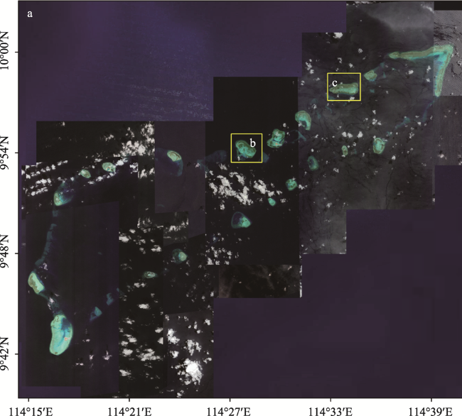
Figure 1 Location of the study area in the southern South China Sea (a. Jiuzhang Reefs; b. Ximen Reef; c. Changxian Reef. Image is from Google Earth)
The in situ survey included sounding and underwater observation and photography on the reef flat substrate. We equipped a Single Frequency Echo Sounder (SFES, ZHD HD-307) under the boat, a Real-Time Kinematic-Differential Global Positioning System (RTK-DGPS, UniStrong G10A) as a base station on the exposed shingle cay, and another RTK-DGPS (UniStrong G10A) as a mobile station on the boat synchronizing with the SFES. The sounding accuracy was ± 0.01 m, and the RTK positioning accuracy was ± 0.008 m. We measured the water depth using SFES along five lines traversing the reef flat within one hour (Figure S2*In addition, we observed and photographed the substrate components of the reef flat through scuba diving.
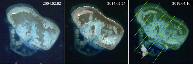
Figure S2 Google Earth images of Ximen Reef at three times. Green lines are the in-situ sounding lines.

2.2 Google Earth images and image processing

Google Earth provides a mass of multi-temporal processed satellite images of the world with high resolution suitable for image analysis. For Ximen Reef, the imaging times include 2004 and each year between 2014 and 2019. Based on the requirements for clarity, i.e., no or little cloudiness and slight waves, we chose and downloaded three images on 2004.02.02, 2014.02.26, and 2019.04.10 with a spatial resolution of 0.2 m (Figure S2) representing the natural state of the reef flat before GCSM, the damaged state shortly after GCSM, and the recovery state, respectively.
We adopted conventional remote sensing methods to analyze the images. There is a small spatial bias between the images from the three times. Considering the image taken on 2014.02.02 as a geometric reference image, 10 individual stationary reef rocks were selected as control points and were employed to adjust for positional bias. The root mean square errors (RMSE) were 1.52 and 0.96 pixels for the control points from the images taken on 2014.02.26 and 2019.04.10, respectively. Images from 2014.02.26 and 2019.04.10 were corrected using quadratic polynomial transformations, and the nearest neighbor interpolation algorithm was used to spatially match to the image taken on 2004.02.02. Since we focused on the areas where GCSM occurred, the reef flat was first extracted through masking the area outside the reef flat (Figure 2b*Based on the distribution of the distinct scars on the image taken on 2014.02.26, the boundary of the mining area was depicted (Figure 2b*In addition, there was some color deviation in the raw images (Figure S2) because of different imaging times and conditions. Similarly, regarding the image taken on 2014.02.02 as a color reference image, the gray values of the three bands (red, green, and blue) were corrected through histogram matching, and the corrected images taken on 2014.02.26 and 2019.04.10 were in accordance with the image from 2014.02.02 in color (Figure 2b).
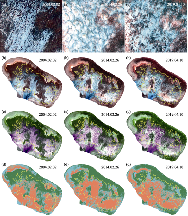
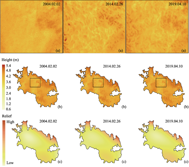
Figure 2 Image analyses of Ximen Reef at three times (a. enlarged part of the mining area showing the details of the mining scars; b. processed images; c. GRB pseudo-color images; d. classified subareas of the substrate (green: LC; cyan: CA; orange: RS) on the reef flat of Ximen Reef at three times. The yellow line shows the range of the mining area according to the distribution of the arc-shaped mining scars on the image from 2014.02.26, and the green rectangle shows the range of the enlarged part)

2.3 Classification and division of the substrate components

The processed images were used to identify and classify substrate components of the reef flat. Green and blue bands are stronger in penetrating water and reflecting relatively deep substrate than red bands. We rebuilt pseudo-color images (Figure 2c) for the three times using a combined order of green, red, and blue (GRB), highlighting the deep substrate that was reflected by the green band but not by the red band. The green and blue bands could be regarded as depth-invariant bands in this study because these two bands are good at penetrating shallow water and reflecting the reef flat substrate. Therefore, an unsupervised classification based on ISODATA (Iterative Self Organizing Data Analysis) was performed using the green and blue bands. Seven unlabeled classes were produced from the images, which almost matched the different distributions of live coral, dead coral, algae, coral skeletal rubble, and sand. In order to identify the changes in the main substrate components at the three times, the seven substrate classes were merged into three substrate categories. The mining area was divided into subareas of these three classes (Figure 2d).

2.4 Height inversion of the substrate

Through subtracting the minimum depth from all data, the measured water depth of the sub-strate was transformed into the substrate height. The gray values of three bands were extracted from the pixels along the sounding traverse lines from the image taken on 2019.04.10. Stumpf and Holderied (2003) suggested an empirical method to retrieve the water depth using the logarithmic ratio of two band reflectance values from satellite images against bathymetric data; their method was accurate at depths less than 10-15 m. We used this method to create different linear fitting relationships between the measured heights of the traverse lines and the logarithmic ratios of two bands. A best fitting model of the logarithmic ratio of blue and red bands against the substrate height was chosen in terms of the goodness of fit (Figure S3), and the mean absolute error (MAE), mean relative error (MRE), and RMSE were calculated for the retrieved heights. This linear fitting model was used to retrieve substrate height from the images, and the height data were used to reconstruct the substrate relief models of the reef flat at the three times (Figure S4 and 4b*Moreover, cubic polynomial fitting was used to simulate the trend surface of the substrate relief on the mining area at the three times (Figure 4c).
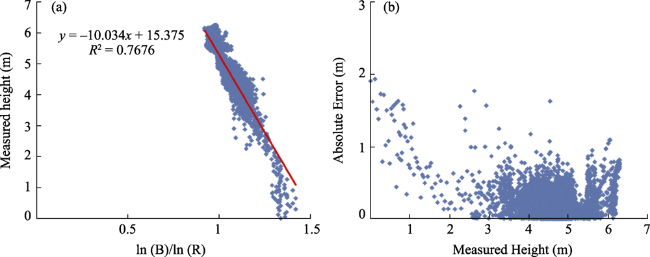
Figure S3 Linear fitting between measured height and logarithmic ratio of blue and red bands (ln(B)/ln(R)) and absolute error distribution against the measured height
Figure 4 Reconstructed substrate reliefs of the mining area at Ximen Reef at three times (a. enlarged part of the reconstructed substrate relief; b. reconstructed substrate relief; c: Relief trend surface)

2.5 Substrate change on the mining area

Area percentages relative to the total reef flat were calculated for the three subareas of the substrate components (Table S1) at the three times, and their differences were calculated between pairs of times (2014.02.26 and 2004.02.02, 2019.04.10 and 2014.02.26) as well (Table S2), revealing the distribution and change of the substrate components on the mining area. The percentile of the retrieved height was calculated for the mining area at the three times (Table S3), and the change of substrate relief was revealed by calculating the height difference (HD) of the mining area between two times. A value of 0.2 m was set as a threshold according to the MAE of the retrieved height data. The substrate relief was seen as no-change when HD was in the range of -0.2-0.2 m between two times, while an HD over 0.2 m or below -0.2 m represented rising and lowering relief, respectively. Finally, the change in substrate relief was mapped on the mining area in two periods (2014.02.02- 2014.02.26 and 2014.02.26-2019.04.10) (Figure 5).
Table S1 Percentages of LC, CA, and RS subareas on the mining area accounting for the total reef flat
LC (%) CA (%) RS (%)
2004.02.02 18.3 7.9 17.6
2014.02.26 10.8 8.2 24.8
2019.04.10 10.4 11.1 22.4
Table S2 Percentage differences of LC, CA, and RS subareas on the mining area accounting for the total reef flat during two periods
Initial class Final class 2004.02.02-2014.02.26 (%) 2014.02.26-2019.04.10 (%)
LC LC 7.9 7.0
CA 4.3 2.6
RS 6.1 1.2
CA LC 1.6 2.2
CA 1.7 3.3
RS 4.7 2.8
RS LC 1.3 1.2
CA 2.3 5.2
RS 14.0 18.4
Table S3 Percentiles of the retrieved height of the mining area at three times
5% (m) 25% (m) 50% (m) 75% (m) 95% (m)
2004.02.02 3.84 4.21 4.42 4.60 4.85
2014.02.26 3.88 4.21 4.42 4.59 4.88
2019.04.10 3.82 4.20 4.42 4.60 4.88
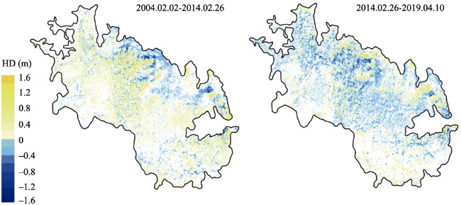
Figure 5 Variation of the substrate relief on the mining area during two periods (-0.2 m ≤ HD ≤ 0.2 m: no-change in relief; HD ≤ -0.2 m: trenches on 2014.02.26 and decreasing relief on 2019.04.10; HD ≥ 0.2 m: mounds on 2014.02.26 and rising relief on 2019.04.10)

3 Results

3.1 Distribution and changes in the substrate components on the mining area

The substrate was covered by various combinations of live coral, dead coral, algae, coral skeletal rubble, and sand. GRB pseudo-color images roughly reflected the main substrate components (Figure 2c*The purple in the figure represents the relatively deep substrate on the reef flat, where the main components are coral rubble and sand, and component identification was obstructed by the water depth. Comparing gray values of the three bands, we found that the reflection of the shallow substrate was consistent within three bands, but the bare coral rubble and sand were reflected more clearly than coral and algae. The green reflects areas of benthic organisms such as coral and algae on the reef flat, and color shades of green reflect different cover densities; the light green is sparse coral cover, and the deep green is dense coral cover. The gray and white correspond to the shallow deposits of bare coral rubble and sand.
Based on the unsupervised classification and the in situ survey, the substrate components were classified into the three classes of live coral (LC), live coral and algae (CA), and bare coral rubble and sand (RS), and the substrate was divided into three subareas of the three classes on the reef flat (Figure 2d*The underwater observations showed that the LC subarea was covered mainly by branched and digitate live corals (Figure 3a), and the CA subarea was partially covered by some live coral and large numbers of dead coral covered by algae (Figure 3b*It is worth noting that the coral bleaching phenomenon was found at both LC and CA subareas (Figures 3a and 3b*The RS subarea was covered by a mass of loose coral rubble and sand (Figure 3c), and trenches and mounds composed of coral rubble and sand were distributed on the RS subarea (Figure 3d).
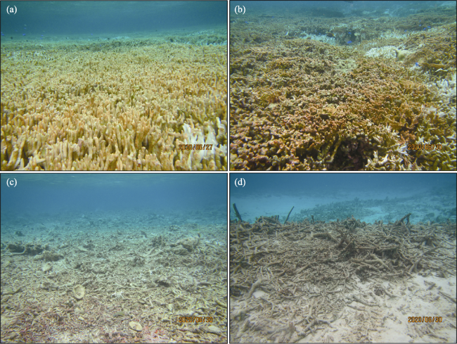
Figure 3 Photos of typical substrate classes on the reef flat of Ximen Reef (a. LC; b. CA; c. RS; d. trenches and mounds. Photos taken by Shi in June 2020)
The reef flat is ~2.36 km2 measured on the image (Figure 2b), and the mining area, which was delimited according to distribution of the mining scars in the 2014.02.26 image, is ~ 1.03 km2 accounting for ~43.9% of the total reef flat. On 2004.02.02 there was no occurrence of GCSM on the reef flat, representing the natural condition without human disturbance of the Ximen Reef (Figures 2a and 2b*Within the mining area, the LC subarea was ~18.3% of the total reef flat; CA and RS subareas were ~7.9% and ~17.3% of the total flat, respectively.
On 2014.02.26 the mining scars point to the occurrence of GCSM at Ximen Reef (Figures 2a and 2b*The LC subarea only retained ~7.9% on the mining area, and ~4.3% and ~6.1% of the LC subarea was converted into CA and RS subareas, respectively; the CA subarea changed into RS subarea by ~4.7% (Table S2*By 2014.02.26, the total LC subarea was ~ 10.8%, a decline of ~7.5% compared with 2004.02.02; changes in the CA subarea were not evident, and the RS subarea reached ~24.8%, an increase of ~7.2% (Table S2*Spatially, the LC subareas at the northern and middle mining areas decreased, and the RS subarea covering separately the southeastern, middle, and western mining areas increased and became connected (Figure 2d).
During 2014.02.26-2019.04.10 there was no new GCSM at Ximen Reef, and the mining scars formed before becoming indistinct on the 2019.04.10 image (Figures 2a and 2b*The cover of the three subareas was transformed during this period (Table S1*Most changes were ~1%-3%; only the RS subarea was converted into CA subarea by a larger percentage (~5.2%*Until 2019.04.10 the total LC area was ~10.4%, not significantly different compared with 2014.02.26; the CA subarea reached ~11.1% and increased by ~2.9%, and the RS subarea was ~22.4% and decreased by ~2.5% (Table S2*Spatially, part of the RS subarea changed to new CA subarea at the middle and southeastern mining areas (Figure 2d).

3.2 Distribution and variation of the substrate relief on the mining area

Based on the inversion model of double bands (Stumpf and Holderied, 2003), the best-fit linear model was chosen between logarithmic ratio of blue and red bands (ln(B)/ln(R)) and measured height data with the goodness of fit (R2) about 0.77 (Figure S3a*The fitting result showed that most of the data points for smaller measured heights were below the linear fitting line (Figure S3a), i.e., the retrieved height (water depth) was higher (lower) than the measured height (water depth) at these points. The largest absolute error appeared for the data points of measured height lower than 1 m (measured depth deeper than 5.27 m) with an error of ~1-2 m (Figure S3b*This is possibly related to the weak reflection of the red band in the relatively deep water. The MAE, MRE and RMSE were 0.18 m, 6.99%, and 0.23 m, respectively, between the retrieved and measured heights.
Using the linear fitting model (Figure S3a), we retrieved height data from the ratio of ln(B)/ln(R) of the images and reconstructed relief models of the reef flat (Figure S4) and the mining area (Figure 4b*At the three times, the average heights of the mining area were relatively equal, 4.39 ± 0.32 m (2004.02.02), 4.40 ± 0.30 m (2014.02.26), and 4.39 ± -0.31m (2019.04.10*The percentiles of the heights were close as well (Table S3), and 90% of the height data were within the range of 3.84-4.85 m (2004.02.02), 3.88-4.88 m (2014.02.26), and 3.82-4.88 m (2019.04.10), meaning that the height difference was only ~1 m on 90% of the mining area in each time. Spatially, the northern margin was relatively high; the southeastern part was second highest, and the central part was relatively low, showing a similar pattern with a high periphery and a low and planar center. The relief trend surfaces were relatively consistent on the mining area at three times (Figure 4c).
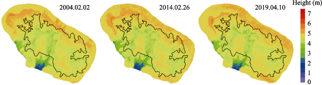
Figure S4 Reconstructed relief of the reef flat of Ximen Reef at three times. The black line shows the range of mining area according to the distribution of the arc-shaped mining scars on the image from 2014.02.26.
Although the whole surface trend of the substrate relief was maintained at the three times, the mining scars point to obvious variation of substrate micro-relief on the mining area (Figures 2a and 2b*GCSM-formed micro-relief is composed of paired arc-shaped trenches and fan-shaped mounds with a significant height difference (Figures 4a and 4b*During GCSM the substrate sediment was stirred up and moved away, forming low-lying arc-shaped trenches, and the sediments of corals, coral rubble, and sand were piled up alongside the trenches, forming high-bulging, fan-shaped mounds. In contrast to the distinct mining micro-relief on 2014.02.26, the micro-relief became indistinct on 2019.04.10 (Figures 4a and 4b), and some of the trenches and mounds tended to level off with the decreasing height difference.
Figure 5 shows variation of the micro-relief in two periods (2014.02.02-2014.02.26 and 2014.02.26-2019.04.10*Until 2014.02.26, the mounds and the trenches accounted for ~44.4% and ~26.1% of the mining area, respectively, and 29.5% of the substrate showed no obvious variation, i.e., GCSM caused variation of over 70% of the substrate relief. The mean heights of the mounds and trenches were about 0.29 ± 0.12 m and -0.28 ± 0.11 m, respectively. Until 2019.04.10, the substrate micro-relief experienced new variation. The new rising relief and new decreasing relief were about 33.2% and 43.2% of the mining area, re spectively, and 23.6% of the substrate showed no obvious variation, i.e., there was still variation of over 75% of the substrate relief under the natural conditions five years after the cessation of GCSM. The mean heights of the increases and decreases in relief were about 0.28 ± 0.11 m and -0.31 ± 0.14 m, respectively. Comparing micro-relief variation of the two periods, the mounds declined by ~41.0% in height, and the trenches increased by ~46.5% in height, while ~54.9% of the mounds and ~48.8% of trenches had no change in height. Moreover, there was a ~12.1% increase in height and ~15.5% decline in height in the no-change area in the previous period.

4 Discussion

Images of Ximen Reef are limited in Google Earth; the earliest image is from February 2004, and the latest image is from April 2019. Ximen Reef was still in a natural state without mining scars in the 2014.02.02 image. The image taken on 2014.02.26 shows extensive and distinct scars on the reef flat, implying that GCSM had occurred at Ximen Reef (Figure 2*Due to the lack of images before 2014, the exact timing of GCSM at Ximen Reef is uncertain, but it is speculated that GCSM appeared no later than 2014. Lee (2016) confirmed that GCSM occurred in the SCS mostly during 2012-2015 according to multi-temporal satellite images. Hence, we believe GCSM at Ximen Reef occurred sometime during 2012-2014.

4.1 Substrate damage caused by giant clam shell mining

The fishermen who were engaged in GCSM in the SCS came mainly from Tanmen Town, Hainan Province, China. We have visited some fishermen in Tanmen Town and obtained details concerning GCSM. GCSM aims to acquire giant clam shells as raw material for handicrafts. The ideal shell is from specimens of Tridacna gigas with complete, large, and thick shells. These types of giant clams are ones that had died a long time ago, and most of the shells had been moved and buried under sediment on the reef flat. The reef flat sediment is composed mainly of loose coral rubble and sand, with a shallow water cover, and the reef emerges out of the water at low tide at Ximen Reef. Hence, the fishermen used a propeller attached a small boat to stir up and remove the sediment and expose the shells to be collected. Actually, GCSM simply collected the shells without collecting live giant clams, as in mining mineral without poaching the wildlife. The reef slope is much deeper than the reef flat, making it unsuitable for GCSM using the propeller. GCSM and its damage occurred only on the reef flat, not on the reef slope.
For Ximen Reef, 2004 is representative of the pre-GCSM natural state, and 2014 reflects a damaged state shortly after GCSM. The mining area shows that nearly half of the reef flat suffered from GCSM. The substrate damage appears as changes in the original natural states of substrate components and relief. On 2004.02.02 the LC subarea was only ~18.3%, close to the RS subarea, meaning that live corals were not dominant in the mining area, even under natural conditions. The relief surface trend was relatively stable in the mining area at the three times (Figure 4b), implying that GCSM had not yet caused a significant change in the surface trend of the substrate relief. During GCSM, live corals and algae were broken and impaired; coral rubble and sand were moved and redeposited. Direct damage from GCSM was reflected in the reduction of LC subarea in the mining area. The approximate 7.5% decline in LC subarea indicates that almost half of the live corals were dead, and that coral communities were destroyed in the mining area. The first survey of the GCSM impact found that live coral cover declined by 10%-20% on the reef flat of Bei Reef in the middle of the SCS during 2012-2014 (Li et al., 2015), worse than the damage at Ximen Reef. However, the relative planar relief under natural conditions had reformed, with an extensive distribution of micro-relief with trenches and mounds covering over 70% of the mining area.
Reef flats represent the most recent growth at sea level of modern coral reefs in shallow water depths. Coral growth is controlled by the tidal changes on the reef flat. Referring to the tidal records at Yongshu Reef located about 170 km southwest of Ximen Reef due to the lack of tidal data at Ximen Reef, the mean high tide level is about 0.38 m, and the mean low-tide level is about -0.27 m (Li et al., 2014*About 90% of the measured water depth ranged within -0.46-0.31 m on the reef flat of Ximen Reef, meaning that most areas of the reef flat were exposed out of water at low tide. Periodic exposure killed some coral species and limited further vertical coral growth. Therefore, corals were not thriving on the reef flat as on the reef slope, and the live coral cover was low on the reef flat. Despite the fact that GCSM led to the losses of live corals on the reef flat, this was not representative of the destruction of the entire coral communities of Ximen Reef. A survey found extensive corals on the reef slope of Ximen Reef (Figure S5), with estimated coral covers of ~20%-40% (Zhou et al., 2019*The previous report exaggerated the destruction by GCSM on coral communities and suggested that GCSM had caused ecocide of the coral reefs in the SCS (Lee, 2016).
Figure S5 Photos of coral communities on the reef slope of Ximen Reef (taken by Yang in 2016 and 2017)
Continuous human activities had disastrous implications for coral reefs in the world. More than 60% of the world's coral reefs are under immediate threat from local human activities, especially from overfishing and destructive fishing, coastal development, and runoff of sediment and pollutants from lands (Burke et al., 2011; Bridge et al., 2013, Hughes et al., 2017*Overfishing and destructive fishing were the most widely practiced activities, affecting more than 55% of the world's coral reefs (Bruno and Selig, 2007; Burke et al., 2011*In China coastal development and overfishing have already destroyed 80% of the coral cover over the past 30 years (Hughes et al., 2013*An average loss of ~65% of the coral cover occurred on the outer reef flat of the Grand Recif of Toliara (GRT) at the southwestern coast of Madagascar between 1962 and 2011, and fisherman gleaning from the reef flats with destructive tools was the main driver of the destruction (Andrefoueot et al., 2013*During 1994-2014, coral cover declined drastically from an average of 24% of the live coral to 96% of the coral rubble at PANGKEP Regency, Spermonde Archipelago, Indonesia, and this was attributed to destructive fishing practices (Haya and Fujii, 2017*Both overfishing and destructive fishing caused a catastrophic decline in fishes, especially in herbivorous fishes, which contributed to a prolonged macoroalgal bloom and resulted in a shift from a coral-dominated phase to an algae-dominated phase preventing coral recruitment and growth (Hughes, 2003, 2007; Rogers and Miller, 2006; Smith et al., 2016*Thus, overfishing occurs over a short time, but its impact is persistent and wide on coral reefs. Different from the chronic remodification of overfishing to ecological components and habitat on coral reefs, GCSM is just a one-time event that caused limited coral loss on the reef flat and did not alter the coral community structure of Ximen Reef.
Another important destructive force toward coral reefs is tropical storms (tropical cyclones, typhoons, and hurricanes*Tropical storms bring severe immediate consequences on coral reefs worldwide. Generally, coral reefs suffer both physical and biological impacts from storms (Lugo-Fernandez and Gravois, 2010), including direct mechanical damages by waves and surges, sedimentation burials, water turbidity, salinity reduction by rain and runoff, as well as damages of coral colonies, and coral cover reduction. Damages of coral reefs vary with changing magnitudes and extent of storms. A study found that storms with maximum winds < 28 m/s for < 12 h inflicted only minor damage on any coral reefs, but storms with winds > 33 m/s and > 40 m/s caused catastrophic damage on coral reefs (Fabricius et al., 2008*The SCS experiences frequent typhoons, which cause losses to the coral communities at different locations. For example, the coral reefs at Eastern Samar, the Philippines, were completely wiped out by typhoon Yolanda in 2013, with ~30%-70% of the reduction in coral cover (Anticamara and Go, 2017*Typhoon Wutip and typhoon Pabuk reduced respectively ~46% and more than 60% of the coral cover in the shallow areas (depth < 3 m) at the Yongle Atolls in the central SCS in 2013 (Yang et al., 2015) and at Pulao Bidong in the southern SCS in 2019 (Safuan et al., 2020*Coral reefs at the Tho Chu Island in the southern SCS were destroyed with a loss of corals of ~40%-80% by Typhoon Ketsana in 2009 (Latypov, 2013*Compared to typhoons, GCSM appears to have similar abrupt impacts on coral reefs, but the damage from GCSM is much lower in magnitude and range than that caused by a typhoon.

4.2 Substrate recovery after giant clam shell mining

There was no new GCSM at Ximen Reef during 2014.02.26-2019.04.10, implying the return to a natural state without human disturbance on the reef flat. Although the LC subarea had an insignificant change during this period, some RS subarea changed into CA subarea at the middle and southeast parts of the mining area. Corals and algae grew again and covered bare rubble and sand on RS subarea. An increase of ~2.9% in CA subarea and a reduction of ~2.5% in RS subarea reflected a slow natural recovery of substrate components on the mining area after GCSM. However, there was variation of ~75% in the substrate micro-relief under the natural conditions that was not less than the magnitude and scope of variation under human disturbance. During 2014.02.26-2019.04.10 nearly half of the mounds and trenches experienced erosion and filling, and the micro-relief tended gradually to become planar as in the natural state from 2004.02.02. Hence, recurrence of the live coral and algae on the RS subarea and rebuilding of the GCSM-formed micro-relief represented a natural recovery of the substrate on the mining area after GCSM.
The preliminary recovery of the substrate was attributed to two factors: one was the end of GCSM, and the other was natural adaptation and regulation. GCSM ceased at Ximen Reef after the last GCSM. In fact, Chinese fishermen were banned from engaging in activities such as mining giant clam shells, poaching coral and other rare species, and destructive overfishing at the coral reefs in the SCS. This is attributed to the constant improvement and strict enforcement of the relevant laws and regulations by the Chinese government. The central government has enacted and amended The Law of the People's Republic of China on the Protection of Aquatic Wildlife (1988, 2004, 2009, 2016, 2018) and The Law of the People's Republic of China on the Marine Environment Protection (1999, 2016, 2017), both including specific terms concerning protecting coral reefs. The local government of Hainan Province, which has jurisdiction over the waters of the SCS, also enacted specific regulations on coral reefs in 1998, Regulations on Coral Reef Protection in Hainan Province, and the regulations were further amended to Regulations on Coral Reef and Giant Clam Protection in Hainan Province in 2016, specifically banning GCSM. The Chinese fisheries administration has issued The South China Sea Fishing Ban each year since 1999. Fishing activities were banned in the SCS from May to August each year to protect fishery resources and improve recovery of marine environments. Moreover, Chinese scientists carried out human-induced ecosystem restoration at multiple coral reefs in the SCS in an attempt to increase species of coral and giant clams through introduction, transplantation, and reproduction (Huang et al., 2020; Zheng et al., 2020).
Without human disturbance, the reef flat of Ximen Reef returned to the natural state. Supplied from the reef slope and the non-mining area on the reef flat, corals and algae attached and grew once again on the substrate of the RS subarea. The southern SCS is influenced by the prevailing winter and summer monsoons, but is also influenced by an occasional typhoon (Zhao et al., 1996*The reef flat was under strong hydrodynamic shear stress driven by the monsoon waves (Wang et al., 2012*Although there is a lack of in situ hydrodynamic observations, the shingle cay located at the northwestern reef flat indicated that there has been enough power moving and piling up coral rubble on the reef flat. Consistent height differences of the substrate between two periods point to the fact that the micro-relief variation caused by GCSM was no greater than that resulting from natural forces. GCSM formed extensive mounds and trenches quickly on the mining area; afterward, the substrate micro-relief was rebuilt by the strong waves and currents on the reef flat that gradually eroded the mounds and filled the trenches.
Coral reefs can usually recover from the impacts of discrete and acute natural disturbances, such as storms that allow sufficient times for new coral recruitment and coral community reassembly (Bythell et al., 2000), while most human disturbances such as overfishing and eutrophication are by contrast so persistent and pervasive as to destroy coral communities and allow no time for recovery (Bythell et al., 2000*The recovery state of coral reefs depends on a long-term monitoring practice before and after disturbances, which has been followed in the GBR and Caribbean for a long period. Observations in the GBR and Caribbean indicated that coral reefs damaged by tropical storms require up to a few years and even decades to recover naturally (Gardner et al., 2005; Adjeroud et al., 2009, 2018; Beeden et al., 2015; Puotinen et al., 2019), and full recovery of coral reefs from the most severe damages can take decades to centuries (Harmelin-Vivien, 1994; Connell, 1997; Hughes and Connell, 1999).
In many cases, coral reefs that suffered multiple impacts from natural and human disturbances show the limited recovery or weak potential to recover. In the Caribbean, for example, post-hurricane coral reefs lacked overall recovery, and this was associated with chronic human impacts (Gardner et al., 2005*Similarly, Andrefoueot et al*2013) concluded that the destroyed benthic habitat on the reef flat of GRT was unlikely to recover due to the non-decreasing chronic human stress in the near future. Coral reefs at Eastern Samar, the Philippines, affected by typhoon Yolanda, faced further collapse without future hope of recovery because of increased fishing pressure (Anticamara and Go, 2017*Coral reef surveys in southern Taiwan suggested that a diverse coral reef assemblage is unlikely to persist on this reef into the future considering frequent disturbances of typhoons combined with constantly growing human population (Kuo et al., 2012*In contrast, that an isolated coral reef in Western Australia recovered rapidly from disturbances is attributed to its isolation from chronic anthropogenic pressures (Gilmour et al., 2013*Human impact is so chronic and severe that it can weaken and even remove the capacity of new coral recruitment and community reassembly to impede coral recovery from multiple disturbances (Hughes and Connell, 1999*The core is that chronic human disturbances, such as overfishing and eutrophication, facilitate fast macroalgae growth and, in turn, reduce and prevent coral recovery (Hughes, 2003, 2007; Smith et al., 2016; MacNeil et al., 2019*Therefore, an additive or synergistic interaction between natural and human disturbances can exacerbate their impacts and may lead to a permanent loss of coral reef recovery.
Ximen Reef is far from the mainland and equal to an isolated coral reef from human. GCSM was a one-time action that was restricted to the reef flat, and its impact is limited. When GCSM finished and is banned, Ximen Reef reverted to a relatively stable natural condition suitable for the substrate recovery of the reef flat. Therefore, the reef flat of Ximen Reef is in a natural recovering process at present. Recovery of the GCSM-damaged reef flat at Ximen Reef is a special case, much like the case of an isolated coral reef recovery in Western Australia (Gilmour et al., 2013*The key is the disappearance of continuous human disturbances at Ximen Reef due to legal prohibition on human activities such as GCSM and overfishing in the SCS. In the SCS, there are many coral reefs that have been damaged by GCSM (Lee, 2016), and the case of Ximen Reef implies that natural recovery of the damaged coral reefs in the SCS can occur as long as human activities are limited and harvesting is banned.

4.3 Main threats to remote coral reefs in the South China Sea

Although the activities of mining and fishing were strictly limited and even banned at the coral reefs in the SCS, this does not mean the remote coral reefs are safe at present or will be in the future. Coral predators including Acanthaster planci (Figure 6a) and Terpios hoshinota (Figure 6b) were found respectively at Ximen Reef and Changxian Reef (Figure 1c), which are located about 12 km northeast of Ximen Reef. Both T. hoshinota and A. planci feed on corals, and their outbreaks cause a large decline in coral cover. Actually, the other coral reefs in the SCS have experienced outbreaks of T. hoshinota and A. planci. T. hoshinota outbreaks were found on coral reefs at Yongxing Island (2008-2010), Taiping Island (2017) and Tioman Island (2013) in the northern, middle, and southern SCS (Shi et al., 2012; Hoeksema et al., 2014; Yang et al., 2018*The years 2008-2010 saw outbreaks of A. planci on the coral reefs at Bruner in the southern SCS (Lane, 2012*At almost the same time, there was an A. planci outbreak at the Xisha Islands in the northern SCS, and then the Xisha Island entered a new period of A. planci outbreaks in 2019 (Li et al., 2019*In the last two years T. hoshinota and A. planci have frequently been found on multiple coral reefs in the southern SCS, implying an increasing potential threat of outbreaks of both coral predators at remote coral reefs in this region.
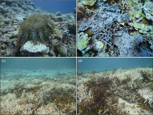
Figure 6 Coral predators and coral bleaching found at remote coral reefs in the southern South China Sea (a. A. planci found at Ximen Reef (Photo taken by Yang in June 2019); b. T. hoshinota found at Changxian Reef (Photo taken by Yang in May 2017); c and d. coral bleaching on the reef flat of Ximen Reef (Photos taken by Shi in June 2020))
Major reefs around the world suffer damage from episodic tropical storms. Threats from typhoons on remote coral reefs cannot be ignored in the SCS. The typhoons through the SCS generally originate from the western Pacific, and the main typhoon region is limited north of 10°N in the SCS (Zhao et al., 1996*In the southern SCS the typhoons occur on average 2-2.5 times each year (Chen et al., 1982); the typhoon-wave lasts for a short time, and its strength is equal to that of the monsoon-wave (Wang et al., 2019*Hence, typhoon impacts on coral reefs are more frequent and intense in the middle and northern SCS than in the southern SCS. As a result of global warming, tropical storms are projected to increase in frequency, duration, intensity, and scale (Knutson et al., 2010; Mendelsohn et al., 2012, Patricola and Wehner, 2018*The increased storms would give coral reefs insufficient time to recover, leading to a loss of recovery for the coral reefs (Salvat and Wiklinson, 2011*A study based on the storm records through lagoon sediments suggested that rising sea surface temperature will lead to more intense tropical storms in the SCS (Yue et al., 2019*It is foreseeable that typhoon storms will increase in the SCS, and the magnitude and extent of typhoon-generated damage will aggravate and further impede future recovery of remote coral reefs in the SCS.
With global warming, it is an indisputable fact that the seawater temperatures are continuously rising. Extreme high temperatures cause coral bleaching events and have killed coral reefs around the globe. In the last decade, coral bleaching has increased in frequency and intensity (Sully et al., 2019*Extreme heat has become the greatest threat to coral reefs worldwide. Several studies reported coral bleaching phenomena at various coral reefs in the SCS, for example, Meiji Reef and Zhubi Reef in the southern SCS in 2007 (Li et al., 2011) and Dongsha Atoll in the northeastern SCS in 2015 (DeCarlo et al., 2017*These studies analyzed the rising of seawater temperature in the SCS and identified typical coral bleaching events caused by the extreme heat.
During an in situ survey in June 2020 we found massive coral bleaching phenomena on the reef flat of Ximen Reef (Figures 6c and 6d*At the same time, the sea surface temperature (SST) rose significantly in the adjacent waters, where the mean SST anomalies were over 2°C (Figure 7a), Degree Heating Week (DHW) was over 7.0 (Figure 7b), and the level of Coral Bleaching Alert Area reached Alert Level 1 (Figure7c) (https://coralreefwatch.noaa. gov/product/5km/*Thus, the coral bleaching on the reef flat was associated with an extremely high SST, implying that an extensive coral bleaching event occurred at coral reefs around Ximen Reef and even extended to the coral reefs in the middle and northern SCS (Figure 7*Compared with human activities, predatory species, and tropical storms, the rising SST and coral bleaching have had a greater and more extensive impact on coral reefs in the SCS, as bleaching weakens the resistance of corals to other forms of damage in addition to directly causing massive coral death. A study on coral growth history in the SCS indicated that, suffering from the rising SST over the past century, coral growth declined mainly in the southern SCS rather than in the middle and northern SCS, and with the continuously rising SST in the SCS in the future, the severest coral growth decline is set to occur in the southern SCS as well (Yan et al., 2019*The southern SCS will become a major heat-influenced region with intensifying of the global warming, where the extreme thermal events and coral bleaching will occur more frequently, posing the primary threat to remote coral reefs.
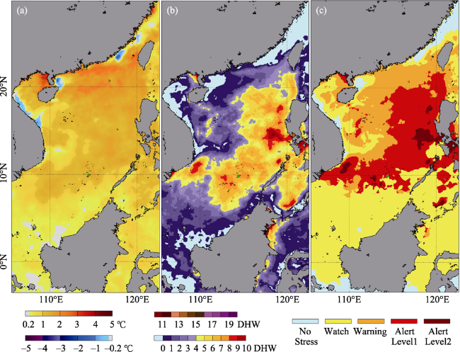
Figure 7 Distribution of parameters indicating coral bleaching event in the South China Sea on June 30, 2020*a. SST anomalies; b. DHW; c. Coral Bleaching Alert Area. Data from Daily Global 5 km Satellite Coral Bleaching Heat Stress Monitoring, Coral Reef Watch, NOAA (https://coralreefwatch.noaa.gov/product/5km/*The green solid circle shows the site of Ximen Reef)
For coral reefs, especially for the remote coral reefs in the SCS, managing local human activities has been critical to preventing degradation of coral reefs and promoting recovery of coral reefs. However, addressing climate change is becoming a new problem and it is the key to the survival of coral reefs. It is difficult to directly combat climate change and its results, such as global warming and intensifying storms, but the measures and practices to control greenhouse emissions can alleviate the risk of global climate change to a certain extent. In addition, they can assist in reducing climate-induced disturbances and making coral reefs more resistant and resilient to relevant disturbances.

5 Conclusions

GCSM had occurred extensively at coral reefs in the SCS. Based on image analysis and in situ surveys, we identified the substrate damage caused by GCSM and followed substrate recovery on the reef flat of Ximen Reef in the southern SCS. GCSM apparently occurred sometime between 2012 and 2014, causing obvious damage to the natural substrate components and substrate relief on the reef flat. GCSM resulted in decreases of LC and CA subareas and an increase of RS subarea and formed micro-relief of mounds and trenches on the mining area, while the substrate relief was consistent within the whole surface trend. However, GCSM-generated damage was restricted to the reef flat. Five years after GCSM, CA, and RS subareas showed a small increase and decline, respectively, and the mounds and trenches experienced slow erosion and filling, reflecting a gradual recovery under natural conditions. The substrate recovery is mainly attributed to the end of GCSM and the legal prohibition on fishing and mining at coral reefs in the SCS. This case study of Ximen Reef is indicative of recovery of the remote coral reefs that suffered from GCSM in the southern SCS. Actually, even though controlling human disturbances, the remote coral reefs in the southern SCS are still confronted with multiple threats, of which the severest is the continuous seawater warming and the resulting coral bleaching events.

Acknowledgement

The authors are grateful to the editor and anonymous reviewers for their hard work and constructive comments and suggestions that have helped improve this paper substantially. We also thank LetPub (www.letpub.com) for its linguistic assistance during the preparation of this manuscript.

Appendix: Supplementary Materials

Supplementary materials (Figures S1-S5 and Tables S1-S3) associated with this paper can be found in the supplementary materials file.
[1]
Adjeroud M, Kayal M, Iborra-Cantonnet C et al., 2018. Recovery of coral assemblages despite acute and recurrent disturbances on a South Central Pacific Reef. Scientific Reports, 8: 9680, doi: 10.1038/s41598-018-27891-3.

DOI PMID

[2]
Adjeroud M, Michonneau F, Edmunds P J et al., 2009. Recurrent disturbances, recovery trajectories, and resilience of coral assemblages on a South Central Pacific Reef. Coral Reefs, 28: 775-780.

DOI

[3]
Andrefoueot S, Guillaume M M M, Delval A et al., 2013. Fifty years of changes in reef flat habitats of the Grand Recif of Toliara (SW Madagascar) and the impact of gleaning. Coral Reefs, 32: 757-768.

DOI

[4]
Anticamara J A, Go K T B, 2017. Impacts of super-typhoon Yolanda on Philippine reefs and communities. Regional Environmental Change, 17: 703-713.

DOI

[5]
Bale R, 2016a. Giant clam poaching wipes out reefs in South China Sea. National Geographic, https://www.nationalgeographic.com/news/2016/06/south-china-sea-coral-reef-destruction/.

[6]
Bale R, 2016b. Critical reefs destroyed in poachers' quest for world's biggest clams. National Geographic, https://www.nationalgeographic.com/news/2016/08/wildlife-giant-clam-poaching-south-china-sea-destruction/.

[7]
Beeden R, Maynard J, Puotinen M et al., 2015. Impacts and recovery from severe tropical cyclone Yasi on the Great Barrier Reef. PLoS ONE, 10(4): e0121272, doi: 10.1371/journal.pone.0121272.

DOI

[8]
Bridge, T C, Hughes T P, Guinotte, J M et al., 2013. Call to protect all coral reefs. Nature Climate Change, 3: 528-530.

DOI

[9]
Bruno J F, Selig E R, 2007. Regional decline of coral cover in the Indo-Pacific: Timing, extent, and sub regional comparisons. PLoS One, 2: e711.

DOI

[10]
Burke L, Reytar K, Spalding M et al., 2011. Reefs at risk revisited. Washington DC: World Resources Institute, p 130.

[11]
Bythell J C, Hillid-Starr Z M, Rogners C S, 2000. Local variability but landscape stability in coral reef communities following repeated hurricane impacts. Marine Ecology Progress Series, 204: 93-100.

DOI

[12]
Chen S J, 1982. Natural situation of Nansha Islands. Ocean Bulletin, 1982, 1(1): 56-62. (in Chinese)

[13]
Connell J H, 1997. Disturbance and recovery of coral assemblages. Coral Reefs, 16: 101-113.

[14]
DeCarlo T M, Cohen A L, Wong G T F et al., 2017. Mass coral mortality under local amplification of 2℃ ocean warming. Scientific Reports, 7: 44586, doi: 10.1038/srep44586.

DOI PMID

[15]
Fabricius K E, De'ath G, Puotinen M L et al., 2008. Disturbance gradients on inshore and offshore coral reefs caused by a severe tropical cyclone. Limnology and Oceanography, 53(2): 690-704.

DOI

[16]
Gardner T A, Cote I M, Gill J A et al., 2005. Hurricanes and Caribbean coral reefs: Impacts, recovery patterns, and role in long-term decline. Ecology, 86(1): 174-184.

DOI

[17]
Gilmour J P, Smith L D, Heyward A J et al., 2013. Recovery of an isolated coral reef system following severe disturbance. Science, 340(5): 69-71.

DOI

[18]
Harmelin-Vivien M L, 1994. The effects of storms and cyclones on coral reefs: A review. Journal of Coastal Research, 12: 211-231.

[19]
Haya L O M Y, Fujii M, 2017. Mapping the change of coral reefs using remote sensing and in situ measurements: A case study in Pangkajene and Kepulauan Regency, Spermonde Archipelago, Indonesia. Journal of Oceanography, 73: 623-645.

DOI

[20]
Hoeksema B W, Waheed Z, de Voogd N J, 2014. Partial mortality in corals overgrown by the sponge Terpios hoshinota at Tioman Island, Peninsular Malaysia (South China Sea). Bulletin Marine Science, 90(4): 989-990.

DOI

[21]
Huang H, Zhang Y Y, Liu C Y, 2020. Coral reef habitat and resources restoration in tropical island marine ranching. Science and Technology for Development, 16(2): 225-230. (in Chinese)

[22]
Hughes T P, Connell J H, 1999. Multiple stressors on coral reefs: A long-term perspective. Limnology and Oceanography, 44: 932-940.

DOI

[23]
Hughes T P, Baird A H, Bellwood D R et al., 2003. Climate change, human impacts, and the resilience of coral reefs. Science, 301: 929-933.

PMID

[24]
Hughes T P, Rodrigues M J, Bellwood D R et al., 2007. Phase shifts, herbivory, and the resilience of coral reefs to climate change. Current Biology, 17: 360-365.

DOI

[25]
Hughes T P, Huang H, Young M A L, 2013. The wicked problem of China's disappearing coral reefs. Conservation Biology, 27: 261-269.

DOI PMID

[26]
Hughes T P, Barnes M L, Bellwood D R et al., 2017 Coral reefs in the Anthropocene. Nature, 546, 82-90.

DOI

[27]
Knutson T R, McBride J L, Chan J et al., 2010. Tropical cyclones and climate change. Nature Geoscience, 3: 157-163.

DOI

[28]
Kuo C Y, Yuen Y S, Meng P J et al., 2012. Recurrent disturbances and the degradation of hard coral communities in Taiwan. PloS ONE, 7(8): e44364, doi: 10.1371/journal.pone.0044364.

DOI

[29]
Lane D J W, 2012. Acanthaster planci impact on coral communities at permanent transect sites on Bruneian reefs, with a regional over view and a critique on outbreak causes. Journal of the Marine Biological Association of the United Kingdom, 92(4): 803-809.

DOI

[30]
Larson C, 2016. Shell trade pushes giant clams to the brink. Science, 351: 323-324.

DOI

[31]
Latypov Y Y, 2013. The composition and structure of reef community at the Chu Island (South China Sea) after Ketsana Typhoon. American Journal of Climate Change, 2: 284-291.

DOI

[32]
Lee V R, 2016. Satellite imagery shows ecocide in the South China Sea. The Diplomat, https://tribunecontentagency.com/article/satellite-imagery-shows-ecocide-in-the-south-china-sea/.

[33]
Li S, Yu K F, Chen T R et al., 2011. Assessment of coral bleaching using symbiotic zooxanthellae density and satellite remote sensing data in the Nansha Islands, South China Sea. Chinese Science Bulletin, 56(10): 1031-1037.

DOI

[34]
Li W F, Liang G J, Xu G, 2014. Analysis on the tide characteristics at the Yongshu Reef of the Nansha Islands. Journal of Ocean Technology, 33(5): 71-77. (in Chinese)

[35]
Li Y C, Han Y D, Chen S Q et al., 2015. Damage of coral reef ecosystem by the giant clam excavation: A case study on North Reef of Xisha Islands. Journal of Applied Oceanography, 34(4): 518-524. (in Chinese)

[36]
Li Y C, Wu Z J, Liang J L et al., 2019. Analysis on the outbreak period and cause of Acanthaster planci in Xisha Islands in recent 15 years. Chinese Science Bulletin, 64: 3478-3484. (in Chinese)

[37]
Lugo-Fernandez A, Gravois M, 2010. Understanding impacts of tropical storms and hurricanes on submerged bank reefs and coral communities in the northwestern Gulf of Mexico. Continental Shelf Research, 30: 1226-1240.

DOI

[38]
MacNeil M A, Mellin C, Matthews S et al., 2019. Water quality mediates resilience on the Great Barrier Reef. Nature Ecology and Evolution, 3: 620-627.

DOI PMID

[39]
Mendelsohn R, Emanuel K, Chonabayashi S et al., 2012. The impact of climate change on global tropical cyclone damage. Natural Climate Change, 2: 205-209.

[40]
Patricola C M, Wehner M F, 2018. Anthropogenic influences on major tropical cyclone events. Nature, 563: 339-346.

DOI

[41]
Puotinen M, Drost E, Lowe R et al., 2019. Towards modelling the future risk of cyclone wave damage to the world's coral reefs. Global Change Biology, doi: 10.1111/gcb.15136.

DOI

[42]
Rogers C S, Miller J et al., 2006. Permanent ‘phase shifts' or reversible declines in coral cover? Lack of recovery of two coral reefs in St. John,US Virgin Islands. Marine Ecology Progress Series, 306: 103-114.

[43]
Safuan C D M, Roselil N H, Bachok Z et al., 2020. First record of tropical storm (Pabuk-January 2019) damage on shallow water reef in Pulau Bidong, south of South China Sea. Regional Studies in Marine Science, https://doi.org/10.1016/j.rsma.2020.101216.

[44]
Salvat B, Wilkinson C, 2011. Cyclones and climate change in the South Pacific. Revolutional Ecology, 66: 105-115.

[45]
Shi Q, Liu G H, Yan H Q et al., 2012. Black disease (Terpios hoshinota): A probable cause for the rapid coral mortality at the Northern Reef of Yongxing Island in the South China Sea. AMBIO, 41: 446-455.

DOI

[46]
Smith J E, Brainard R, Carter A et al., 2016. Re-evaluating the health of coral reef communities: Baselines and evidence for human impacts across the central Pacific. Proceeding of Royal Society B, 283: 20151985. http://dx.doi.org/10.1098/rspb.2015.1985.

[47]
Stumpf R P, Holderied K, 2003. Determination of water depth with high resolution satellite imagery over variable bottom types. Limnology and Oceanography, 48: 547-556.

DOI

[48]
Sully S, Burkepile D E, Donovan M K et al., 2019. A global analysis of coral bleaching over the past two decades. Nature Communications, 10: 1264. https://doi.org/10.1038/s41467-019-09238-2.

DOI PMID

[49]
Wang L Q, Xia Y Q, Liang B C et al., 2019. Basic research on the characteristics of hazardous waves in the South China Sea. Acta Oceanologica Sinica, 41(3): 23-34. (in Chinese)

[50]
Wang T T, Liang G J, Zhou Z L et al., 2012. Analysis of the wave characteristics at Yongshu Reef. Marine Science Bulletin, 31(3): 278-282. (in Chinese)

[51]
Yan H Q, Shi Q, Yu K F et al., 2019. Regional coral growth responses to seawater warming in the South China Sea. Science of the Total Environment, 670(20): 595-605.

DOI

[52]
Yang H Q, Yu K F, Zhao M X et al., 2015. Impact on the coral reefs at Yongle Atoll, Xisha Islands, South China Sea from a strong typhoon direct sweep: Wutip, September 2013. Journal of Asian Earth Sciences, 114: 457-466.

DOI

[53]
Yang S Y, Chen H J, Ho M J et al., 2018. Outbreak of coral-killing cyanobacteriasponge, Terpios hoshinota, in Taiping Island (Itu Aba), Spratlys, South China Sea. Bulletin Marine Science, 94(4): 1543-1544.

DOI

[54]
Yue Y F, Yu K F, Tao S C et al., 2019. 3500-year western Pacific storm record warns of additional storm activity in a warming warm pool. Paleogeography, Paleoclimatology, Paleoecology, 521: 57-71.

DOI

[55]
Zhao H T, Wen X S, Sun Z X et al., 1996. Natural characteristics of coral reefs, Nansha Islands of South China Sea. Acta Oceanologica Sinica, 18(5): 61-70. (in Chinese)

[56]
Zheng X Q, Li Y C, Liang J L et al., 2020. Performance of ecological restoration in an impaired coral reef in the Wuzhizhou Island, Sanya, China. Journal of Oceanology and Limnology, https://doi.org/10.1007/s00343-020-9253-z.

[57]
Zhou S N, Shi Q, Zhou G Y et al., 2019. Geomorphic features of coral shingle cays in the Nansha Islands. Marine Sciences, 43(6): 48-59. (in Chinese)

Outlines

/