Special Issue: Fluvial and Geomorphological Features

Spatiotemporal differentiation and development process of tidal creek network morphological characteristics in the Yellow River Delta

  • MOU Kuinan , 1, 2 ,
  • GONG Zhaoning , 1, 2, * ,
  • QIU Huachang 1, 2
Expand
  • 1. College of Resource Environment and Tourism, Capital Normal University, Beijing 100048, China
  • 2. MCA Key Laboratory of Disaster Assessment and Risk Prevention, Capital Normal University, Beijing 100048, China
*Gong Zhaoning (1976-), Professor, specialized in remote sensing technology and geoscience application. E-mail:

Mou Kuinan (1996-), specialized in remote sensing technology and geoscience application. E-mail:

Received date: 2021-08-03

  Accepted date: 2021-09-20

  Online published: 2022-01-25

Supported by

National Key R&D Program of China(2017YFC0505903)

National Natural Science Foundation of China(41971381)

Copyright

© 2021 Science Press Springer-Verlag

Abstract

Tidal creeks are the main channels of land-sea ecosystem interactions, and their high dynamics are an important factor affecting the hydrological connectivity of tidal flats. Taking the Yellow River Delta as the research area, we selected remote sensing images obtained during five periods from 1998 to 2018 as the data sources. Based on the spatial analysis function in GIS, the typical morphological characteristics of tidal creeks, such as the level, length, density, curvature, bifurcation ratio, and overmarsh path length (OPL), were extracted to characterize the degree of development of the tidal creeks in the Yellow River Delta wetlands. The spatio-temporal evolution of the tidal creeks was studied, and the development process and the characteristics of the tidal creeks during the different stages of development were investigated. The results revealed that (1) The number, density, and bifurcation ratio of tidal creeks exhibit an increasing trend, but the growth of the trend is slowing. The number of tidal creeks increased by 44.9% from the initial stage of the Yellow River diversion to the late stage of the wetland restoration, but it only increased by 26.2% from the late stage of the wetland restoration to the slow expansion of the Spartina alterniflora*2) The curvature of the tidal creeks on the landward side is greater than that on the seaward side*3) The development degree of tidal creek has spatial heterogenetiy, which is Area III > Area II > Area I*4) The drainage efficiency is significantly correlated with the tidal creak density and bifurcation ratio. Based on the analysis of the various morphological parameters and the drainage efficiency, it was found that after the rapid change in the tidal creek system in the early stage, the tidal creeks entered a state of slow change, and the development state of the tidal creeks tends to be in dynamic balance. The results of this study are expected to provide scientific support for the sustainable development and utilization of coastal tidal flats.

Cite this article

MOU Kuinan , GONG Zhaoning , QIU Huachang . Spatiotemporal differentiation and development process of tidal creek network morphological characteristics in the Yellow River Delta[J]. Journal of Geographical Sciences, 2021 , 31(11) : 1633 -1654 . DOI: 10.1007/s11442-021-1915-z

1 Introduction

A tidal creek is a tidal channel formed by ocean dynamics, especially tidal action. It is the most active micro-topographic unit of land-sea interaction in tidal flats (Lv et al., 2016) and is an important channel for the exchange of energy, materials, and genes between land and marine ecosystems (Naiman et al., 1993*The morphological characteristics of tidal creek systems are similar to those of terrestrial river systems, but they differ from the one-way flow system of terrestrial river networks, and the tidal creek system exhibits two-way flow under the actions of waves and tides (Li et al., 1997).
The morphological characteristics of the tidal creek network development are the key factors affecting the hydrological connectivity and stability of tidal flats. In recent years, scholars in China and abroad have carried out a series of studies on the heterogeneity of typical morphological parameters. Marani et al*2002) constructed geometric parameters describing the local meandering of tidal creeks and quantitatively characterized the changes in the landform characteristics of tidal flats. Novakowski et al*2004) analyzed typical salt marsh tidal creeks in the southeastern United States using 0.7-m aerial data and used morphological characteristics such as the level and density of the surface river network as references for quantitatively characterizing the morphological characteristics of intertidal tidal creeks. In addition, studies have shown that there is a significant linear relationship between the length of the tidal creek system and the catchment area (Marani et al., 2003*Since it takes decades for a tidal creek network to reach an equilibrium state (Williams et al., 2002), it is also necessary to study the development of tidal creeks' morphological characteristics on a long time scale. The activity degree and morphological characteristics of tidal creek systems are highly heterogeneous due to the influences of multiple driving factors. Chen et al*2001) analyzed the development characteristics of tidal creeks in an area after a seawall was moved outward, and they found that the tidal creeks near the seawall rapidly deteriorated, while the stable tidal creeks farther away from the seawall were activated. Shen et al*2003) studied the geomorphic characteristics of the Spartina alterniflora invasion area from 1999 to 2000 and found that Spartina alterniflora caused significant difference in the morphological characteristics of the tidal creeks in the salt marsh and the plain tidal creeks by changing the dynamic characteristics of the tidal current and the composition of the surface material of the beach. Through a 13-year study in central Jiangsu, Wu et al*2003) found that the expansion of salt marsh vegetation and the reclamation of tidal flats caused planar morphological changes and swings of the tidal creek. Zhao et al*2019) reported that the quantitative analysis of the morphological characteristics of tidal creeks was helpful in understanding the evolution of tidal creeks and the spatial distribution of tidal flats. The differences in the morphological characteristics of tidal creeks are mainly related to the vegetation distribution, tidal flat width, and hydrodynamic conditions.
A dense tidal creek system has developed in the Yellow River Delta region. Due to the comprehensive influence of tides, runoff, storm surges (Gong et al., 2019), sea level rise, and human activities (Li et al., 2007), the morphological characteristics of the tidal creeks are complex and variable, with high spatio-temporal heterogeneities. The development of tidal creeks depends on the delicate balance between the sedimentary processes and hydrodynamics. Since the diversion of the Yellow River in 1996, a large number of coastal dam projects and wetland restoration projects have been carried out in the region, which has broken the original ecological balance. Since 2010, Spartina alterniflora has undergone a period of rapid expansion (Zhang et al., 2019; Gong et al., 2020), which has greatly changed the morphological characteristics of the tidal creeks, resulting in the loss of salt marsh wetland habitat and posing a substantial threat to the stability of tidal flat and coastal engineering (Chen et al., 2001*Therefore, it is essential to study the variations in the tidal creek morphological characteristics driven by human activities and the Spartina alterniflora invasion.
With the increase in the scale of coastal engineering construction and the increasing attention paid to the tidal flat environment, researchers have carried out a series of studies on the development and evolution of tidal creeks. Marani et al*2003) improved the method of calculating the tidal creek drainage density to ensure that it represents the degree of development of tidal creek networks with different degrees of tortuosity and different branching patterns. Vandenbruwaene et al*2012) and Kearney et al*2016) concluded that vegetation can increase the drainage density of tidal creeks. Through experiments, Zhou et al*2014) found that under different tidal conditions, the drainage efficiency of a tidal creek system increases rapidly in the earlier stage, and the adjustment process to a new equilibrium state is slow. Through field experiments, Vandenbruwaene et al*2013) found that the drainage density increases significantly during the evolution from a low-altitude bare tidal flat to a high-altitude vegetation marsh. However, the calculation of the key morphological parameters of tidal creek networks, such as the drainage density, lacks a wide range of research. Steel et al*1997) were the first to propose an evolutionary model of the development of tidal creeks, and they concluded that there are four major stages in the development of tidal creeks. Yan et al*2002) support this view, but sometimes, natural or human factors lead to a jump in the development of a tidal creek or the reversal of the development pattern. Through laboratory analysis, Stefanon et al*2009) and Vlaswinkel et al*2001) found that tidal creeks develop rapidly in the initial development stage. However, after this stage, tidal creeks tend to be stable, and only minor adjustments will be made locally. Chirol et al*2018) proposed a new equilibrium relationship related to the overmarsh path length (OPL), but they did not take into account the flow velocity, wind, waves, the sedimentation rate in the marsh, and the attracting and drainage effects of the sediments and vegetation, which affect the development of tidal creek networks. Most studies of the development process of tidal creeks have been limited to laboratory analysis. Some researchers have used evolutionary models to qualitatively describe the development of tidal creeks, but few have conducted quantitative characterization of the development process of tidal creeks under the synergistic influences of multiple factors.
In this study, based on important human events, such as the diversion of the Yellow River, the restoration project of the Yellow River Delta wetland, and the invasion of Spartina alterniflora, the key morphological characteristics of tidal creeks, including the length, level, density, curvature, bifurcation ratio, and OPL, were selected for five key periods from 1998 to 2018. The spatio-temporal and heterogeneities of the tidal creek morphological characteristics were quantitatively analyzed, the morphological heterogeneity of the tidal creek network was explored before and after large-scale human activities and the Spartina alterniflora expansion, and the development process and characteristics of the tidal creeks during the different stages of development were investigated in depth. The results of this study provide important decision-making support for the rational development and utilization of regional coastal tidal flats and for further understanding the evolution of the morphological characteristics of tidal creek systems under the influences of natural and human activities.

2 Overview of the study area and research methods

2.1 Overview of the study area

The Yellow River Delta National Nature Reserve in Shandong Province is a wetland nature reserve that was mainly established for the protection of the newborn wetland ecosystem and rare and endangered birds. It is located in Dongying City, on both sides of the new and old Yellow River estuaries. It is a national nature reserve and was approved by the State Council in 1992. It has three management stations: the Yiqianer, Huanghekou, and Dawenliu stations. Its geographical coordinates are 118°33°-119°20.7°E, 37°35°-38°12°N. The tidal creeks in the Yellow River Delta are crisscrossed and distributed in an obvious network pattern, and the various wetland landscapes are distributed in patches. In addition, in terms of the existing form of wetlands, the wetlands in the Yellow River Delta are predominantly perennial waterlogged wetlands (Liu et al., 2001*The research scope of this paper is the current Yellow River Estuary. Due to its unique geographical location, it is affected by the interactions of river, sea, and land, which form unique land and water conditions and hydrological conditions. However, since 1980, the sediment content of the Yellow River has decreased significantly, resulting in a substantial decrease in the sediment flow from the river estuary. This led to seawater back irrigation and serious coastal erosion, and soil salinization in the study area became increasingly obvious (Peng et al., 2009*Moreover, the soil salinization in the study area has become increasingly severe. The morphological characteristics of the tidal creek network in the Yellow River Delta exhibit large regional differences. In order to explore the spatio-temporal heterogeneities of the morphological characteristics of the tidal creek network in different regions, the old channel of the Yellow River before Qingbacha in 1996 and the current channel of the Yellow River are taken as the boundary. The entire study area can be divided into three regions (Figure 1): the north bank of the Yellow River (Area I), the east side of the south bank of the Yellow River (Area Ⅱ), and the west side of the south bank of the Yellow River (Area Ⅲ).
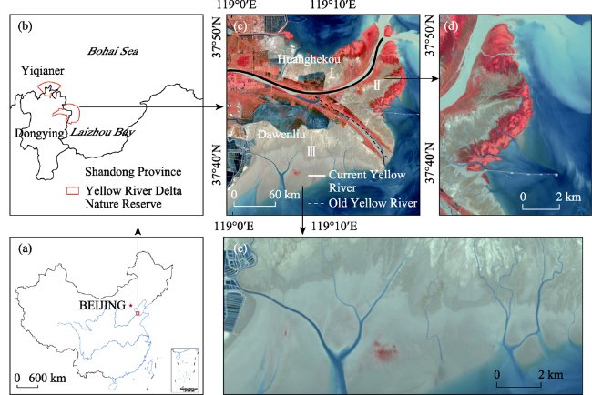
Figure 1 Location of the Yellow River Delta National Nature Reserve, Shandong Province, China (Area I on north bank of Yellow River, Area II on east side of south bank of Yellow River, and Area III on west side of south bank of Yellow River)

Note: This map is based on the standard map with approval number GS (2016)1569 on the standard map service website of the National Basic Geographic Information Center; the base map has not been modified.

2.2 Data source and data preprocessing

The Landsat remote sensing data were obtained from the National Aeronautics and Space Administration (NASA*Landsat5 TM images taken in 1998, 2004, and 2008 and Landsat8 OLI images taken in 2013 and 2018 were selected, with a spatial resolution of 30 m × 30 m. The images were preprocessed, including radiometric calibration, atmospheric correction, and geometric correction. The transverse Mercator 50 north latitude projection (UTM50N) was used, with WGS84 as the reference plane. Based on the Google Earth Engine (GGEE) platform, the improved fuzzy C-means clustering algorithm (MFCM) and the Gaussian Matching Filter (GMF) algorithm were used to extract the tidal creeks (Wang et al., 2019; Gong et al., 2020*The accuracy was verified through visual interpretation with reference to Google Earth and the collected high spatial resolution images in the neighboring period (Table 1), and the overall extraction accuracy was 85%. Complete tidal creek data were obtained after manual supplementation. Due to the frequent ebb and flow of the tides in the delta region, the tidal flat area of the exposed tidal creek is affected by the tidal level, and the dynamic distribution of the tidal creek in a given year cannot be effectively characterized by data for a single point in time. Therefore, the extraction results of the high- and low-tidal creeks in the same year were superimposed to obtain the tidal creeks' data for five important time nodes in the study area. The tidal creeks were classified using a fast automatic classification algorithm (Gong et al., 2020) in order to extract the morphological parameters of the tidal creeks. The characteristic variables were optimized using the random forest algorithm and were used to extract the typical wetland plant communities of Spartina alterniflora, Phragmites australis, and Suaeda salsa (Zhang et al., 2019; Gong et al., 2020*The accuracy was verified by referring to the visual interpretation of the Google Earth images in the neighboring period, and the overall extraction accuracy was >90%. In the study area, Phragmites australis mostly grows on both banks of the old and new Yellow River channels and in the restored area, but it almost does not grow in the tidal creek area. Suaeda salsa plants are short and grow mostly in coastal tidal flats and heavy salinized areas. Areas with a high flooding frequency are not conducive to the survival of the Suaeda salsa seedlings (Wang et al., 2019*In addition, previous research results have shown that Suaeda salsa has little influence on the morphological characteristics and development process of tidal creeks, but tidal creeks have a strong influence on the growth of Suaeda salsa (Fa et al., 2020*Spartina alterniflora is mainly distributed from the lower part of the high-tidal zone to the lower part of the middle-tidal zone in the coastal intertidal zone. Once Spartina alterniflora colonizes around a tidal creek, it expands outward on both sides of the tidal creek along the direction of its development, rapidly occupying the area surrounding the tidal creek and the living space of native species (Gong et al., 2020*Therefore, in this paper, the investigation of the influence of vegetation on the tidal creeks mainly focuses on the invasion of Spartina alterniflora.
Table 1 Essential information of remote-sensing images
Time Image type Path/Row Imaging time
Experimental image
1998 TM 121/34 04/19,06/06,09/26,12/15
2004 TM 121/34 03/18, 05/21, 09/10, 10/12
2008 TM 121/34 04/14, 07/03, 10/07, 10/23
2013 OLI 121/34 04/02, 06/15, 09/03, 11/22
2018 OLI 121/34 03/25, 07/31, 09/17, 10/19
Portal image
2013 SPOT-6 - 09/03
2018 GF-1 PMS - 07/16

2.3 Research methods

2.3.1 Temporal gradient of the study

In 2002, the Yellow River Delta National Nature Reserve restored 3,333.3 hm² of wetland by building dikes along the coast and diverting the Yellow River water to increase the freshwater supply to the wetlands. Another 6666.7 ha of wetland ecological restoration was completed during a project in 2006 (Shan et al., 2007*In 2008, Spartina alterniflora was first found on the north bank of the Yellow River. It expanded rapidly from 2010 to 2016, and the area of Spartina alterniflora reached 15.15 km² in 2013. From 2016 to 2018, the expansion slowed down, but the area still reached 40.53 km² in 2018. Therefore, in order to study the spatiotemporal differentiation of the tidal creek network, five key periods were selected in the study period, including the initial Yellow River diversion (1998), the initial wetland restoration (2004), the later wetland restoration (2008), the rapid expansion period of Spartina alterniflora (2013), and the slow expansion period (2018*Key parameters representing the degree of development of the tidal creeks, such as the level, number, length, density, curvature, bifurcation ratio, and OPL, were extracted to analyze the spatio-temporal heterogeneities and the morphological characteristics of the development stages of the tidal creek network.

2.3.2 Definition of tidal creek morphological parameters

The level of the tidal creeks is based on the Horton-Strahler principle (Horton et al., 1945; Strahler et al., 1952).
The length of a tidal creek (L) is described by its central axis (Wu et al., 2013).
The tidal creek density (D) refers to the density of tidal creeks in the catchment area. It can directly reflect the degree of development of the tidal creeks in the area (Wu et al., 2020), and it is one of the indicators used to measure the degree of development of tidal creeks in tidal flats. It is represented by the total length of the tidal creeks in the tidal flat per unit area (Marani et al., 2003*The calculation formula is given below:
$D=\Sigma L/A$
where $\Sigma L$is the total length of the tidal creeks in the tidal flat, and A is the area of the tidal flat.
The curvature r of a tidal creek reflects the degree of curvature of the tidal creeks, and it is usually represented by the ratio of the length of the tidal creek to the straight-line distance between the two endpoints of the tidal creek (Ichoku et al., 1994*The greater the curvature of the tidal creek, the greater the bending degree of the tidal creek. The calculation formula is shown below:
$r=L/{L}'$
where L is the length of the tidal creek, and L° is the straight-line distance between both ends of the tidal creek.
The bifurcation ratio (R) (Horton et al., 1945) is one of the indicators that reflect the degree of development of tidal creeks. It is usually expressed as the number of confluence points of the tidal creeks in a tidal flat per unit area. The calculation formula is shown below:
$R=\Sigma N/A$
where ΣN is the number of junctions of the tidal creeks in the tidal flat, and A is the area of the tidal flat.

2.3.3 Measurement of the degree of tidal creek development

The length of the non-channel path can quantitatively represent the drainage efficiency of the tidal creek system, which is of great significance for evaluating the degree of development of the tidal creek system (Chirol et al., 2018*This index is defined as the minimum slope distance between all of the points in the catchment area and the tidal creek system (Lohani et al., 2006*The tide gully catchment area is usually approximated as a convex hull, which is combined with Chirol's method to determine the catchment boundary. The shore side is the reclaimed area's boundary, the seaward side is the line at the end of the tidal creek, and in the middle and upper sections of the adjacent tidal creek, the adjacent tidal basin is determined by an equal distance. In order to quantitatively describe the non-channel path length of the tidal creek catchment, the OPL is often used to evaluate its drainage efficiency. Because the elevation gradient of the intertidal wetland is usually very low, the slope distance is usually replaced by the planar distance (Chirol et al., 2018*The semi-log model was used to fit the relationship between the length of the non-channel path and its probability density distribution function in each tidal creek's catchment area. The OPL was obtained from the negative reciprocal of the slope beyond the first 50 values of the probability distribution (i.e., the slope of the fitting line) (Figure 2*The OPL represents the average distance from any point in the catchment area to the tidal creek system. The smaller the value, the greater the density of the tidal creek system and the higher the drainage efficiency (Marani et al., 2003).
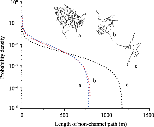
Figure 2 Probability density function of overmarsh path length evaluated for tidal creek network

3 Results and analysis

3.1 Spatio-temporal heterogeneities of the tidal creek network morphological characteristics

3.1.1 Level and number

Tidal creek level can quantitatively represent the morphological characteristics of the tidal creek system. The higher the tidal creek system grade, the higher the degree of tidal creek development, the larger the corresponding catchment area, and the greater the tidal prism (Mest et al., 2010*The number of tidal creeks conforms to the law of the number of rivers defined by Horton: as the level of the river increases, the number of corresponding rivers decreases exponentially (Horton et al., 1945*Based on the Horton-Strahler classification principle, the tidal creek system in the Yellow River Delta mainly contains first- and second-level tidal creeks, accounting for about 93% of the total number of tidal creeks, and the fifth highest level tidal creeks are located in Area III (Figure 3).
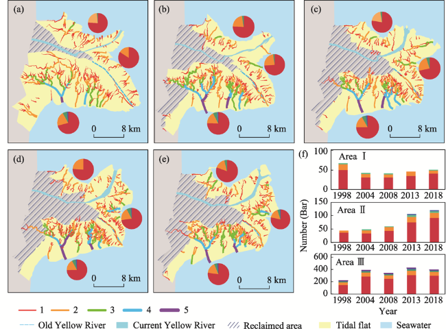
Figure 3 Distribution of various levels of tidal creeks in the Yellow River Delta National Nature Reserve: (a) 1998, (b) 2004, (c) 2008, (d) 2013, (e) 2018, and (f) statistics of the number of different levels of tidal creeks in each area annually
The level and number of the tidal creeks exhibit obvious spatio-temporal heterogeneities. As shown in Figure 3, from 1998 to 2004, the number of tidal creeks of each level in Area I decreased significantly, and then, it increased slowly from 2004 to 2018. The main reason for this may be that the diversion of the Yellow River led to a large reduction in the number of tidal creeks (Yu et al., 2018*After the adjustment of the amounts of water and sand, the tidal creeks in Area I recovered to a relatively stable and slow development state. In Area Ⅱ, the number of level-1 tidal creeks declined from 1998 to 2004, but the number of tidal creeks of various levels continued to increase after 2004. The main reason for this is that the large amount of silt blockage during the initial stage of the diversion caused siltation of the low-level tidal creeks, which reduced the number of tidal creeks. After the water and sediment regulation experiments, the number of tidal creeks increased significantly. In addition, due to the changes in the Yellow River Estuary, Area II has continued to experience siltation; so, more tidal creeks can develop, and the number of tidal creeks is also increasing. The number of tidal creeks of each level in Area Ⅲ is increasing, and the tidal creek level is the largest in the study area. After the Yellow River was diverted, the sediment supply to the mouth of the Yellow River was lost (Huang et al., 2004), and the tidal flats were continuously eroded and washed by sea water, which caused the tidal creek network to continue to develop. From 2004 to 2008, the number of low-level tidal creeks decreased. The main reason for this is that the wetland project reclaimed a large area of tidal flats (Huang et al., 2004; Shan et al., 2007), resulting in a large number of low-level tidal creeks being cut off, filling with silt, and gradually disappearing.

3.1.2 Length

Generally speaking, low-level tidal creek systems have larger numbers, shorter lengths, and simple structures, while higher-level tidal creek systems are more complex. Although the number is small, the length is longer. In the entire study area, nearly 80% of the tidal creek systems are at first or second level, but their length accounts for only 30% of the total length of the entire tidal creek system. In contrast, the number of third-, fourth-, and fifth-level tidal creek systems account for only 20% of the total, but their total length accounts for 70% of the total length of the tidal creek system. In Figure 3, it can be seen that the tidal flats in Area I are dominated by first- and second-level tidal creek systems, and the lengths of the primary and secondary tidal creeks are relatively large.
In order to explore the quantitative relationship between the level and length of the tidal creeks, the tidal creeks in the three areas were fitted. Due to the limited number of higher-level tidal creeks, only the first- and second-level tidal creeks were fitted, and the length frequency was found to be normally distributed. The length characteristics of the different levels of tidal creeks in the three areas are similar. As can be seen from Figure 4, the lengths of the first- and second-level tidal creeks in Area I and Area II are larger than those in Area III. The main reason for this may be that the tidal creeks in Area I are basically stable, while in Area II, due to the beach-fixing effect of Spartina alterniflora, the transformation speed between different levels of tidal creeks is slower (Gong et al., 2021*In Area III, the tidal creeks developed rapidly, and the tidal creeks continued to change from low-level to high-level ones. In addition, due to the increase in the absorption of the ebb tide on the beach surface by the branching tidal creeks on both sides and the reduction in the confluence area, the higher-level tidal creeks were degraded to the lower-level ones (Gong et al., 2021), and the conversion frequency between the different levels of tidal creeks was higher, resulting in low-level tides. The ditch cannot be extended, and the length is short.
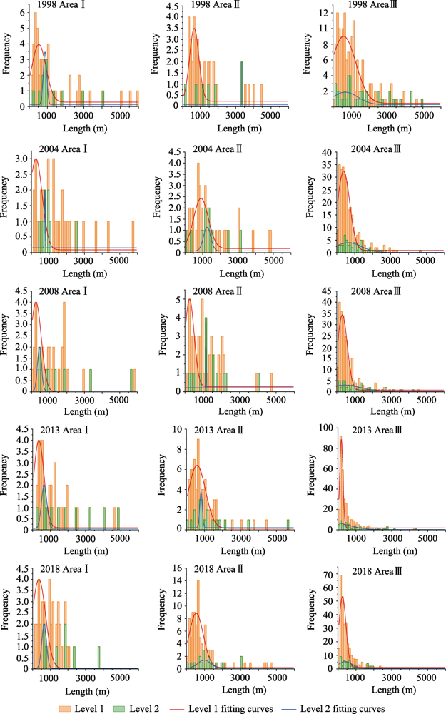
Figure 4 Frequency diagram of tidal creek length in different districts and levels; red and green lines are fitting curves for the first- and second-level creeks, respectively

3.1.3 Density

The greater the tidal creek density, the higher the degree of tidal creek development. The density of the tidal creeks was the smallest in Area I, followed by Area II, and the density was the largest in Area III. In Area I, after the Yellow River was rerouted, the number of tidal creeks was greatly reduced (Yu et al., 2018), which led to a decrease in the tidal creek density. After 2008, the tidal creek density remained basically unchanged, and the tidal creek system had a low degree of development but was relatively stable. In Area Ⅱ, the density of the tidal creeks increased after 2004, and during the expansion stage of Spartina alterniflora from 2013 to 2018, the density of the tidal creeks increased (Figure 5*The main reason for this is that after the water and sediment regulation experiment in 2002, the silted river channel in the lower part of the Yellow River was washed away, and the number of tidal creeks increased abnormally (Yu et al., 2018), which increased the density of the tidal creeks. The expansion of Spartina alterniflora increased the roughness of the underlying surface and raised the water level in the return channel. At low tide, more tidal water needs to be discharged (Shen et al., 2003*Therefore, the number of the tidal creeks increases, and the density of the tidal creeks also increases. Thus, the expansion of Spartina alterniflora promotes the development of tidal creeks. Area Ⅲ lost its sand supply after the Yellow River was diverted, and due to the continuous erosion by the tidal water, the area of the tidal flats decreased, and tidal creeks developed rapidly, resulting in a greater density of tidal creeks. The wetland restoration led to a reclamation of a large area of tidal flats and the cut-off upstream tidal creeks, making it impossible for the tidal creeks to extend upward. In order to maintain the overall balance in the tidal flats, the tidal creek system must adjust its shape, constantly swinging and developing laterally to increase the density of the tidal creeks. After 2008, the reclaimed area basically stopped increasing, the development speed of the tidal creek system slowed down, and the density of the tidal creeks increased slowly; thus, forming a relatively stable stage.
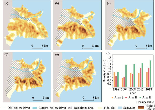
Figure 5 Kernel density of tidal creek in the Yellow River Delta National Nature Reserve: (a) 1998, (b) 2004, (c) 2008, (d) 2013, (e) 2018, and (f) statistics of tidal creek density by area

3.1.4 Curvature

The higher the curvature of the tidal creek, the greater the degree of bending and the stronger the meandering. In the initial stage after the Yellow River diversion, the curvature of the tidal creeks in the study area was relatively small, and the tidal creek development was low. As can be seen from Figure 6, the curvature of the tidal creeks in Area I was larger because the lowest amount of erosion by seawater occurred in this area (Gong et al., 2021*The curvature of the tidal creeks in Area II was generally higher (Figure 6f*The main reason for this is that this area is the Yellow River Estuary, which has sand source replenishment; so, the tidal flat changes from erosion to siltation, and the influence of the ocean dynamics is reduced. The curvature of the tidal creeks increased rapidly during the rapid expansion of Spartina alterniflora. This shows that the expansion of Spartina alterniflora promotes the development of meanders in the tidal creeks to a certain extent. The curvature of the tidal creeks near the wetland restoration area in Area Ⅲ was relatively large because the wetland restoration cut off the upward development channels of the tidal creeks. In order to maintain the balance of the tidal creek system, the tidal creeks are forced to change their shapes and increase their curvatures to maintain their drainage efficiency. Therefore, large-scale tidal flat reclamation activities have a certain promotion effect on the development of tidal creek meanders. In the coastal part of this area, the tides continuously wash the tidal creeks as the tides rise and fall, and the hydrodynamic force is strong (Wu et al., 2013), which makes the tidal creeks straighter. Moreover, when the degree of bending of a tidal creek reaches a certain level, the water volume in the tidal creek increases suddenly during heavy rain, storm surges, and other weather events, and the curved trench section will accelerate the speed of the cutting and straightening (Ren et al., 1983*This also shows that strong ocean dynamics have an inhibitory effect on the development of tidal creek meanders.
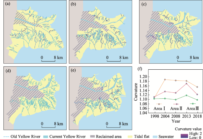
Figure 6 Curvature of tidal creek in the Yellow River Delta National Nature Reserve: (a) 1998, (b) 2004, (c) 2008, (d) 2013, (e) 2018, and (f) statistics of tidal creek curvature by area

3.1.5 Bifurcation ratio

The greater the bifurcation ratio of the tidal creeks, the higher the degree of development.
The bifurcation ratio in Area I was small and relatively stable, the bifurcation ratio in Area II increased during the rapid expansion period of Spartina alterniflora, and the bifurcation ratio in Area III was the largest. In the early stage of wetland restoration in 2004, the siltation of the current estuary in Area I increased the tidal flat area, and the development of tidal creeks was low, which reduced the tidal creek bifurcation ratio (Figures 7a and 7b*By the late stage of wetland restoration in 2008, the area of tidal flats decreased due to the restoration of the wetlands, and the tidal creeks continued to develop, which increased the bifurcation ratio (Figures 7b and 7c*From 2013 to 2018, a large amount of Spartina alterniflora grew in Area II, which to a certain extent, promoted the development of tidal creek branching and increased the degree of tidal creek development. From 1998 to 2004, due to the restoration of the wetlands and the erosion by tidal water, the area of tidal flats in Area III decreased, tidal creeks developed rapidly, and the number of tidal creeks increased, which significantly increased the bifurcation ratio. After the recovery of the wetlands, the tidal creek bifurcation ratio continued to increase to a more stable state. Under the combined influence of the diversion of the Yellow River, seawater erosion, tidal flat reclamation activities, and Spartina alterniflora expansion, the changes in the tidal creek bifurcation ratio were basically consistent with the changes in the tidal creek density.
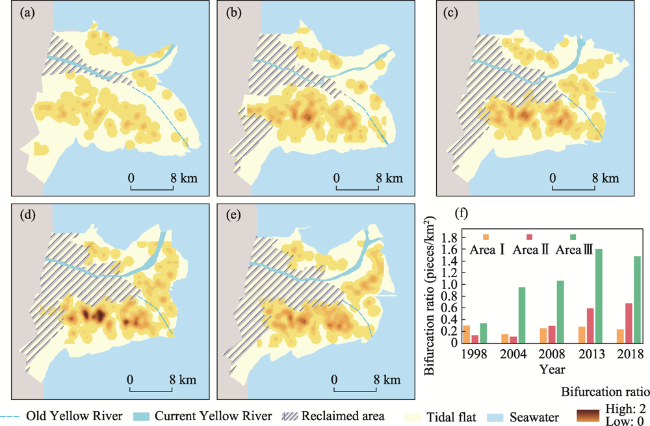
Figure 7 Distribution of tidal creek branch points in the Yellow River Delta National Nature Reserve: (a) 1998, (b) 2004, (c) 2008, (d) 2013, (e) 2018, and (f) statistics of tidal creek bifurcation ratio by area

3.2 Analysis of the drainage efficiency and development process of the tidal creek network

3.2.1 Correlation analysis of the drainage efficiency and morphological parameters of the tidal creek network

The shorter the OPL, the higher the drainage efficiency and the higher the degree of development of the tidal creek system. There is a certain correlation between the OPL of the tidal creek system and the morphological characteristics of the tidal creeks. Correlation analysis of the OPL of each catchment area and the morphological characteristics of the tidal creeks was conducted. The correlations between the OPL and the tidal creek density, curvature, and bifurcation ratio had correlation coefficients of about -0.82, 0.37, and -0.78, respectively. The OPL had a strong correlation with the tidal creek density, that is, the smaller the OPL, the greater the density of the tidal creek system, and the higher the drainage efficiency of the tidal creek system. The correlation between the OPL and the bifurcation ratio was also relatively high, and it exhibited a weak correlation with the average curvature of the tidal creeks.
Affected by the diversion, the number of tidal creeks was greatly reduced, the average trough length of the tidal creek system increased, the drainage efficiency decreased, and the development of tidal creeks was low. From 2004 to 2008, after the water and sand regulation experiments, the tidal creeks developed rapidly, the density increased, the bifurcation ratio increased, the OPL of the tidal creek system decreased, and the drainage efficiency increased. After 2008, the development of the tidal creeks was basically stable, the sediment deposition increased the area of the tidal flats, the density of the tidal creeks decreased slightly, and the OPL of the tidal creek system increased. After 2013, with the expansion of Spartina alterniflora, the density of the tidal creeks increased, the OPL of the tidal creek system decreased slightly, the drainage efficiency increased, and the level of tidal creek development was basically stable.
In Area Ⅱ a side-curved spur dike was built in 2006, which caused a large difference in the drainage efficiencies of the tidal creeks on the north and south sides of the spur dike (Figure 8f*Due to the diversion of the Yellow River, a new entrance to the sea was formed in Area II, a large amount of sediment was deposited, the area of the tidal flats increased, and the density of the tidal creeks decreased. Therefore, in 2004, the OPL of the tidal creek system increased, and the drainage efficiency decreased. After the side-curved spur dike was completed in 2006, the sediment that should have moved to the south side along with the tide was intercepted, and a large amount of silt was deposited on the north side of the spur dike (Li et al., 2019*This caused the northern coastline to extend toward the sea, the area of the tidal flats to increase, and the OPL of the tidal creek system to increase. However, with the rapid expansion of Spartina alterniflora, the required drainage efficiency was greater, which increased the density of the tidal creeks and reduced the OPL of the tidal creek system. The tidal flats on the south side of the side-curved spur dike were eroded by seawater, and the tidal flat area decreased. Under the erosion by seawater, the tidal creek system developed rapidly, the density gradually increased, the OPL decreased, and the drainage efficiency increased.
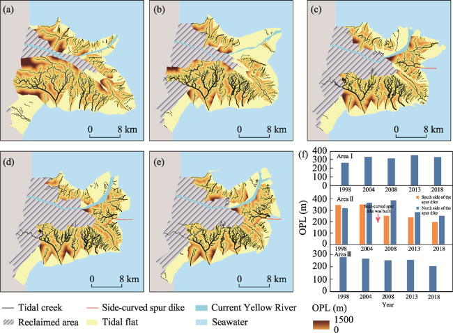
Figure 8 Overmarsh path length of main tidal creek systems in the Yellow River Delta National Nature Reserve: (a) 1998, (b) 2004, (c) 2008, (d) 2013, (e) 2018, and (f) statistical chart showing overmarsh path length of the main tidal creek networks annually
The OPL of the tidal creeks in Area Ⅲ steadily decreased. The main reason for this is that after the Yellow River diversion, the tidal flats where sediments had been deposited in the past were gradually eroded away by the seawater. In addition, the wetland restoration project resulted in the reclamation of the beach that was originally far from the tidal creeks. With the continuous development of the tidal creeks, the density of the tidal creeks continued to increase, the OPL continued to decrease, the drainage efficiency increased, and the degree of development of the tidal creek system increased.

3.2.2 Stages of tidal creek development

The effects of natural and human activities on different regions of the Yellow River Delta study area are different, and there are significant differences in the activity level and morphological characteristics of the tidal creek system in each region. There is no clear time period from the formation of the tidal creeks to its extinction, and it may take 4-13 years for a tidal creek system to reach a balanced state (Williams et al., 2002*According to the evolution model proposed by Steel and Pye, combined with the various morphological parameters and the drainage efficiency of a tidal creek, the development stage of the tidal creek system in each area was analyzed.
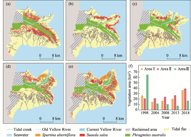
Figure 9 Changes in vegetation distribution in the Yellow River Delta National Nature Reserve: (a) 1998, (b) 2004, (c) 2008, (d) 2013, (e) 2018, and (f) statistics of vegetation coverage by area
The diversion of the Yellow River significantly changed the hydrodynamic conditions of the tidal flats. The initial stage of the Yellow River diversion was from 1998 to 2004. Affected by the diversion, the number of the tidal creeks in Area I decreased significantly, the various morphological parameters basically decreased, and the drainage efficiency decreased. At this time, Area I was in the juvenile stage of the tidal creek development, and the tidal creek system began to develop again. Area Ⅱ became the new Yellow River Estuary. Sedimentation reduced the density of the tidal creeks, the vegetation area remained basically unchanged, the drainage efficiency decreased, and the tidal creek system began to develop. The original estuary in Area Ⅲ lost its sand supply and was most strongly affected by the tidal erosion. In addition, in the early stage of wetland restoration, large areas of the tidal flats were reclaimed, blocking the upward development of the tidal creeks and making the tidal creek system very active. The various morphological parameters increased, the drainage efficiency significantly improved, and the tidal creek system reached a higher degree of development. Therefore, the tidal creek system was in the adolescent stage.
In the early stage of wetland restoration from 2004 to 2008, in Area I, the morphological parameters basically increased, and the efficiency of the tidal drainage improved. In 2008, it was discovered that Spartina alterniflora had begun to colonize the area, and the tidal creeks developed rapidly. At this time, the tidal creek system was in the adolescent stage. In 2002, the Yellow River was tested for water and sediment regulation for the first time, which eased the sedimentation in the downstream area and promoted the development and evolution of the tidal creeks in Area II. In addition, the current sedimentation at the mouth of the Yellow River has caused drastic changes in the location of the tidal creeks. Moreover, Spartina alterniflora began to colonize, the tidal creeks developed rapidly, the various morphological parameters increased, and the drainage efficiency increased. The tidal creek system was in the adolescent stage. During this period, the reclaimed area of the tidal flats in Area III reached the maximum, the tidal creeks swung the most, the bifurcation ratio and density increased, the upstream curvature of the tidal creek increased, and the drainage efficiency continued to increase. At this time, the tidal creek system was still in the adolescent stage.
In the late stage of wetland restoration from 2008 to 2013, in Area I, the number of tidal creeks increased slowly, all of the morphological parameters remained relatively stable, the drainage efficiency increased slightly, and the tidal creek development slowed. The tidal creek system was in the middle stage of development. In Area Ⅱ, the various morphological parameters increased rapidly, the drainage efficiency increased, and the tidal creek system was still in the adolescent stage. The recovery of the wetlands in Area Ⅲ was basically over, and the recovered wetlands cut off the upward development channel of the tidal creeks, but the loss of the tidal creeks was compensated for by the development of small low-level tidal creeks, which maintained the balance in the tidal flats. The activity of the tidal creek system significantly decreased, the various morphological parameters maintained a relatively stable state of growth, and the drainage efficiency improved. At this time, the tidal creek system was in the middle stage of development.
During the expansion period of Spartina alterniflora from 2013 to 2018, in Area I, the morphological parameters remained relatively stable, the drainage efficiency increased slightly, and the tidal creek system was in the middle stage of development. This period was the expansion period of Spartina alterniflora. The area occupied by Spartina alterniflora increased rapidly in the estuary in Area II, which significantly weakened the hydrodynamic force of the tidal flats (Wang et al., 2006), increased the development of the tortuosity of the tidal creeks, and increased the roughness of the underlying surface. The water level in the return channel in the Spartina alterniflora salt marsh tidal flat increased at ebb tide; thus, the drainage efficiency improved. At this time, the area was in the middle stage of development, and the development of the tidal creeks slowed down. In Area Ⅲ, all of the morphological parameters, except for the density of the tidal creeks, decreased, the drainage efficiency maintained a relatively stable state of growth, and the development of the tidal creeks slowed down and reached a balanced state. At this time, the tidal creek system was still in the middle stage of development. However, the amount of vegetation in Area III gradually increased. Under the rapid planting of vegetation, the development stage of the tidal creek system may be reversed in this area, and the adolescent stage with high tidal creek activity may once again be ushered in.

4 Discussion and conclusions

4.1 Discussion

In this study, the morphological characteristics of a large-scale, long-term tidal creek network and its development process were investigated under different conditions caused by the influences of ocean dynamics, human activities, and vegetation. Similar to the Yellow River Delta, the development of the tidal creeks in Jiuduansha in the Yangtze River Delta, Chongming Island, and the coast of central Jiangsu is affected by ocean dynamics, vegetation, and human activities (Liu et al., 2012; Wu et al., 2013).
The tidal current is controlled by the elevation gradient of the beach surface, causing erosion of the beach surface, which plays an important role in the development of the tidal creeks (D'Alpaos et al., 2005*The newly created tidal creeks are rapidly extending under the influence of traceable erosion and are widened and deepened due to the increase in the tidal velocity (Stefanon et al., 2009*After the diversion of the Yellow River in 1996, Area I and Area II were still affected by seawater micro-erosion, and the morphological characteristics of the tidal creeks changed greatly. Seawater erosion has become the main theme in Area III. The number, density, and bifurcation ratio of the regional tidal creeks have increased significantly. This shows that seawater erosion promotes changes in tidal creek morphology and the rapid development of tidal creeks. After 2008, due to the sediment replenishment of the upper reaches of the Yellow River and the expansion of Spartina alterniflora, entire Area I, along with the northern side of the side-curved spur dike in Area II, changed from micro-erosion to pure sedimentation, and the impact of the ocean dynamics was minimal. In Area Ⅲ, due to the Yellow River diversion and the construction of spur dams, the sediment supply was insufficient, and the impacts of the reduction of the amounts of water and sediments in the basin and the erosion by seawater led to a decrease in the tidal flat area (Murray et al., 2019; Li et al., 2021*Although Area III is most affected by the ocean dynamics, the changes in the morphological characteristics of the tidal creeks have begun to slow down, and the number, density, and bifurcation ratio of the tidal creeks have changed slightly. This may be because the area of the tidal flats has shrunk and the scouring effect of the flowing water has weakened. Erosion alone cannot further promote the changes in the morphological characteristics of the tidal creeks. The morphological characteristics of the tidal creeks have gradually stabilized (Stefanon et al., 2009) and reached an equilibrium state (Fagherazzi et al., 2004).
At present, the vegetation in the study area is mainly concentrated in Area I and Area Ⅱ. Area Ⅲ is dominated by mud flats, with scattered vegetation, mainly Suaeda salsa. The sedimentation in the estuary, which has suitable amounts of salt, water, and nutrients, provides good colonization conditions for the salt marsh vegetation in Area I and Area II (Zhang et al., 2019*Plants can stabilize both sides of the tidal creeks and promote the continuous development of the tidal creek system (Wilson et al., 2014; Kearney et al., 2016*During the rapid expansion period of Spartina alterniflora, the curvature, density, and bifurcation ratio of the tidal creeks in Area II increased significantly. The expansion of Spartina alterniflora promoted the winding development of the tidal creeks, increased the branching of the tidal creeks, and increased the drainage efficiency of the tidal creeks. These results are consistent with the results obtained by Shen et al*2003) based on a one-year field survey. During the period of slow expansion of Spartina alterniflora, the changes in the morphological characteristics, such as the tidal creek density and bifurcation ratio, slowed down. At this time, in the high and dense Spartina alterniflora zone, the vegetation became an important factor restricting the continued development of the tidal creeks (Liu et al., 2012*However, the situation identified by Chen et al*2013) in Chongming East Beach of the Yangtze River Estuary is as yet not seen in the Yellow River Delta, where vegetation grows, and the density of tidal gullies is often small. According to satellite remote sensing images, the expansion of Spartina alterniflora initially reached Area III in 2018 (Zhang et al., 2019*The vegetation distribution has shown a trend of expanding from the edges of the tidal flats to the center of the tidal flats in Area III. Taking into account the strong colonization ability and rapid expansion trend of Spartina alterniflora (Schwarz et al., 2014; Zhang et al., 2020), Area III may be transformed into a salt marsh in future, and the tidal creeks may change drastically again.
Human activities have a significant influence on the development of tidal creeks. In contrast to the restoration of the wetlands in the Yellow River Delta reclaimed area, the main purpose of the Yangtze River Delta reclamation is to stabilize the beach (Lu et al., 2013), and the main purpose of the efforts related to the central Jiangsu coast is to develop arable land and aquaculture (Li et al., 2015*From 2004 to 2008, due to the restoration of the wetlands in the Yellow River Delta, a large area of tidal flats was reclaimed, and the upstream tidal creeks were cut off. The tidal creeks were forced to change their shape and increase their curvature and density to maintain their drainage efficiency. Therefore, the large-scale reclamation of the tidal flats in the study area has had a certain promotion effect on the development of tidal creek meanders. In addition, the beach surface that was located far away from the tidal creeks was reclaimed, the OPL decreased, the drainage efficiency increased, the tidal creek density increased, and the degree of development of the tidal creek system increased. Similar to the study of Wu et al*2013) in central Jiangsu, the tidal flat reclamation activities reduced the length of the low-level tidal creeks, while the density of the tidal creeks in the mid-tidal zone increased. The large-scale reclamation activities on the Chongming East Beach of the Yangtze River Estuary, which were conducted to stabilize the beach, have gradually eliminated the tidal creek system in the northeast (Lu et al., 2013*The completion of the side-curved spur dike in the Yellow River Delta resulted in the development of the tidal creek network which is different between the north and south sides of the dike. The construction of the spur dam led to the interception of the sediment load (Syvitski et al., 2008), and the sedimentation on the north side of the spur dam (Li et al., 2019) decreased the drainage efficiency until the rapid expansion of Spartina alterniflora. The drainage efficiency gradually increased. The sediments on the south side of the spur dike were intercepted, the tidal flats were continuously eroded by seawater (Liu et al., 2012; Chen et al., 2013), more tidal creeks were developed, and the drainage efficiency increased. Due to the human activities in the Yellow River Delta, the overall trend of the tidal creek development in Area III has been the largest, followed by that in Area II, while the trend in Area I has not changed. The trend towards erosion on the south bank of the Yellow River has not changed. However, the top of Jiuduansha in the Yangtze River Estuary changed from weak erosion before the deep-water roadway construction to strong siltation (Du et al., 2005), which changed the hydrodynamic conditions needed for the development of tidal creeks and caused differences in the development of the tidal creeks on the north and south sides. Therefore, the development of the tidal creeks in the Yangtze River Delta has been more affected by human activities than that in the Yellow River Delta.

4.2 Conclusions

With the support of digital processing of remote sensing images and geospatial information technology, in this study, the effects of important human events such as the Yellow River Delta wetland restoration project and the construction of side-curved spur dike, as well as the effects of natural processes such as the invasion of Spartina alterniflora and ocean dynamics, were investigated. The spatio-temporal heterogeneities of the tidal creek morphological characteristics were quantitatively analyzed, and the development process and the characteristics of the tidal creek during different development stages were explored in depth. The main conclusions of this study follow*1) The tidal creeks in the study area in the Yellow River Delta exhibited significant regional differences between the north and south. The degree of tidal creek development was the largest in Area III, followed by Area II, while Area I was the least developed. The number, density, and bifurcation ratio of the tidal creeks exhibited an increasing trend, but the growth trend gradually slowed down. Due to the combined effects of seawater erosion and vegetation expansion, the lengths of the first and second level tidal creeks in Area I and Area II were larger than that in Area III. The curvature of the tidal creeks on the landward side was greater than that on the seaward side. The OPL was more strongly correlated with the tidal creek density and bifurcation ratio*2) The morphological characteristics of the tidal creeks are closely related to the ocean dynamics, vegetation development, and human activities. After experiencing rapid changes to the tidal creek system in the early stage, the three areas are currently in the middle stage of development. The tidal creek system as a whole has entered a state of slow change, and its developmental state is in dynamic equilibrium.
[1]
Chen C J, 2001. Change in tide creek after mudflat being enclosed in the middle coast in Jiangsu province. Marine Science Bulletin, 20(6): 71-79. (in Chinese)

[2]
Chen Y, He Z F, Li B et al., 2013. Spatial distribution of tidal creeks and quantitative analysis of its driving factors in Chongming Dongtan, Shanghai. Journal of Jilin University (Earth Science Edition), 43(1): 212-219. (in Chinese)

[3]
Chirol C, Haigh I D, Pontee N et al., 2018. Parametrizing tidal creek morphology in mature saltmarshes using semi-automated extraction from LIDAR. Remote Sensing of Environment, 209: 291-311.

DOI

[4]
D'Alpaos A, Lanzoni S, Marani M et al., 2005. Tidal network ontogeny: Channel initiation and early development. Journal of Geophysical Research: Earth Surface, 110(F2): 1-14.

[5]
Du J L, Yang S L, Zhang W X et al., 2005. Study of influence on erosion and accumulation of Jiuduansha Tidal Island by Deep-Water Channel Project at North Passage of the Yangtse River. The Ocean Engineering, (3): 78-83. (in Chinese)

[6]
Fagherazzi S, Gabet E J, Furbish D J, 2004. The effect of bidirectional flow on tidal channel planforms. Earth Surface Processes and Landforms, 29(3): 295-309.

DOI

[7]
Fan Y B, Zhou D M, Ke Y H et al., 2020. Quantifying the correlated spatial distributions between tidal creeks and coastal wetland vegetation in the Yellow River Estuary. Wetlands, 40(6): 2701-2711.

DOI

[8]
Gong Z N, Mou K N, Wang Q W et al., 2021. Parameterizing the Yellow River Delta tidal creek morphology using automated extraction from remote sensing images. Science of The Total Environment, 769: 144572.

DOI

[9]
Gong Z N, Wang Q W, Guan H L et al., 2020. Extracting tidal creek features in a heterogeneous background using Sentinel-2 imagery: A case study in the Yellow River Delta, China. International Journal of Remote Sensing, 41(10): 3653-3676.

DOI

[10]
Gong Z N, Zhang C, Zhang L et al., 2020. Assessing spatiotemporal characteristics of native and invasive species with multi-temporal remote sensing images in the Yellow River Delta, China. Land Degradation & Development, 32(3): 1338-1352.

DOI

[11]
Gong Z, Zhang Y S, Zhao K et al., 2019. Advances in coastal storm impacts on morphological evolution of mud tidal flat-creek system. Advances in Science and Technology of Water Resources, 39(4): 75-84. (in Chinese)

[12]
Horton R E, Horton R, Horton H, 1945. Erosional development of streams and their drainage basins, hidrophysical approach to quantitative morphology. Journal of the Japanese Forest Society, 37(6): 257-262.

[13]
Huang H J, Fan H, 2004. Change detection of tidal flats and tidal creeks in the Yellow River Delta using Landsat TM/ETM+ image. Acta Geographica Sinica, 59 (5): 723-730. (in Chinese)

[14]
Ichoku C, Chorowicz J, 1994. A numerical approach to the analysis and classification of channel network patterns. Water Resources Research, 30(2): 161-174.

DOI

[15]
Kearney W S, Fagherazzi S, 2016. Salt marsh vegetation promotes efficient tidal channel networks. Nature communications, 7: 12287-12294.

DOI

[16]
Li C C, 1997. On the estuarine system and its automatic adjustment. Acta Geographica Sinica, 52(4): 353-360. (in Chinese)

[17]
Li J L, Yang X P, Tong Y Q, 2007. Progress on environmental effects of tidal flat reclamation. Progress in Geography, 26(2): 43-51. (in Chinese)

[18]
Li J G, Pu L J, Xu C Y et al., 2014. The changes and dynamics of coastal wetlands and reclamation areas in central Jiangsu from 1977 to 2014. Acta Geographica Sinica, 70(1): 17-28. (in Chinese)

[19]
Li P, Ke Y H, Bai J H et al., 2019. Spatiotemporal dynamics of suspended particulate matter in the Yellow River Estuary, China during the past two decades based on time-series Landsat and Sentinel-2 data. Marine Pollution Bulletin, 149: 110518-110533.*-+

DOI

[20]
Li P, Ke Y H, Wang D W et al., 2021. Human impact on suspended particulate matter in the Yellow River Estuary, China: Evidence from remote sensing data fusion using an improved spatiotemporal fusion method. Science of The Total Environment, 750: 141612-141667.

DOI

[21]
Liu H Y, Lv X G, Liu Z Q, 2001. Deltaic wetlands in Bohai Sea: Resources and development. Journal of Natural Resources, 16(2): 101-106. (in Chinese)

[22]
Liu J H, Yang S L, Shi B W et al., 2012. Topography and evolution of the tidal trench in the eastern Chongming tidal flat, Changjiang River Estuary. Journal of Marine Sciences, 30(2): 43-50. (in Chinese)

[23]
Lohani B, Mason D C, Scott T R et al., 2006. Extraction of tidal channel networks from aerial photographs alone and combined with laser altimetry. International Journal of Remote Sensing, 27(1): 5-25.

DOI

[24]
Lu B, Jiang X Z, 2013. Reclamation impacts on the evolution of the tidal flat at Chongming Eastern Beach in Changjiang estuary. Journal of Remote Sensing, 17(2): 342-349. (in Chinese)

[25]
Lv T Y, Gong Z, Zhang C K et al., 2016. Reviews of morphological characteristics and evolution processes of silty mud tidal creeks. Journal of Hohai University (Natural Science Edition), 44(2): 178-188. (in Chinese)

[26]
Marani M, Belluco E, D'Alpaos A et al., 2003. On the drainage density of tidal networks. Water Resources Research, 39(2): 1040.

[27]
Marani M, Lanzoni S, Zandolin D et al., 2002. Tidal meanders. Water Resources Research, 38(11): 1-7.

[28]
Mest S C, Crown D A, Harbert W, 2010. Watershed modeling in the Tyrrhena Terra region of Mars. Journal of Geophysical Research: Planets, 115(E9): 1-27.

[29]
Murray N J, Phinn S R, Dewitt M et al., 2019. The global distribution and trajectory of tidal flats. Nature, 565(7738): 222-225.

DOI

[30]
Naiman R J, Decamps H, Pollock M, 1993. The role of riparian corridors in maintaining regional biodiversity. Ecological applications: A publication of the Ecological Society of America, 3(2): 209-212.

DOI

[31]
Novakowski K I, Torres R, Gardner LR et al., 2004. Geomorphic analysis of tidal creek networks. Water Resources Research, 40(5): 5401-5413.

[32]
Peng J, Chen S L, 2009. The variation process of water and sediment and its effect on the Yellow River Delta over the six decades. Acta Geographica Sinica, 64(11): 1353-1362. (in Chinese)

[33]
Ren M E, Zhang R S, Yang J H et al., 1983. The influence of storm tide on mud plain coasts: With special reference to Jiangsu Province. Marine Geology and Quaternary Geology, 3(4): 1-24. (in Chinese)

[34]
Schwarz C, Ye Q H, Wal D et al., 2014. Impacts of salt marsh plants on tidal channel initiation and inheritance. Journal of Geophysical Research: Earth Surface, 119(2): 385-400.

[35]
Shan K, 2007. Theory, methodology and practices of wetland ecological restoration in Yellow River Delta Nature Reserve. Wetland Science and Management, 3(4): 16-20. (in Chinese)

[36]
Shen Y M, Zhang R S, Wang Y H, 2003. The tidal creek character in salt marsh of Spartina alterniflora Loisel on strong tide coast. Geographical Research, 22(4): 520-527. (in Chinese)

[37]
Steel T J, Pye K, 1997. The development of salt marsh tidal creek networks: Evidence from the UK. Canadian Coastal Conference, 1: 267-280.

[38]
Stefanon L, Carniello L, D'Alpaos A et al., 2009. Experimental analysis of tidal network growth and development. Continental Shelf Research, 30(8): 950-962.

DOI

[39]
Strahler A N, 1952. Dynamic basis of geomorphology. Geological Society of America Bulletin, 63 (9): 923-938.

DOI

[40]
Syvitski J P M, 2008. Deltas at risk. Sustainability Science, 3(1): 23-32.

DOI

[41]
Vandenbruwaene W, Bouma T J, Meire P et al., 2013. Bio-geomorphic effects on tidal channel evolution: impact of vegetation establishment and tidal prism change. Earth Surface Processes and Landforms, 38(2): 122-132.

DOI

[42]
Vandenbruwaene W, Meire P, Temmerman S, 2012. Formation and evolution of a tidal channel network within a constructed tidal marsh. Geomorphology, 151/152: 114-125.

DOI

[43]
Vlaswinkel B M, Cantelli A, 2011. Geometric characteristics and evolution of a tidal channel network in experimental setting. Earth Surface Processes and Landforms, 36(6): 739-752.

DOI

[44]
Wang A J, Gao S, Jia J J, 2006. Impact of Spartina alterniflora on sedimentary and morphological evolution of tidal salt marshes of Jiangsu, China. Acta Oceanologica Sinica, 28(1): 92-99. (in Chinese)

[45]
Wang Q, Luo M, Qiu D D et al., 2019. Effect of hydrological characteristics on the recruitment of Suaeda salsa in coastal salt marshes. Journal of Natural Resources, 34(12): 2569-2579. (in Chinese)

DOI

[46]
Wang Q W, Gong Z N, Guan H L et al., 2019. Extracting method of tidal creek features under heterogeneous background at Yellow River Delta using remotely sensed imagery. Chinese Journal of Applied Ecology, 30(9): 3097-3107. (in Chinese)

DOI PMID

[47]
Williams P B, Orr M K, Garrity N J, 2002. Hydraulic geometry a geomorphic design tool for tidal marsh channel evolution in wetland restoration projects. Restoration Ecology, 10(3): 577-590.

DOI

[48]
Wilson C A, Hughes Z J, Fitzgerald D M et al., 2014. Saltmarsh pool and tidal creek morphodynamics: Dynamic equilibrium of northern latitude saltmarshes? Geomorphology, 213: 99-115.

DOI

[49]
Wu D L, Shen Y M, Fang R J, 2013. A morphological analysis of tidal creek network patterns on the central Jiangsu coast. Acta Geographica Sinica, 68(7): 955-965. (in Chinese)

[50]
Wu Y N, Wang Y, Zhang Z M, 2020. Effects of tidal creek morphology on succession of wetland plant communities in the Yellow River Delta. Ecological Science, 39(1): 33-41. (in Chinese)

[51]
Yan S G, 2002. The growth and evolution of tidal creeks on the prograding mud flat in Jiangsu province[D]. Nanjing: Nanjing Normal University. (in Chinese)

[52]
Yu X J, Zhang Z S, Xue Z S et al., 2018. Morphological characteristics and connectivity of tidal channels in the Yellow River Delta for 7 Periods since 1989. Wetland Science, 16(4): 517-523. (in Chinese)

[53]
Zhang L, Gong Z N, Wang Q W et al., 2019. Wetland mapping of Yellow River Delta wetlands based on multi-feature optimization of Sentinel-2 images. Journal of Remote Sensing, 23(2): 313-326. (in Chinese)

[54]
Zhang X, Xiao X, Wang X et al., 2020. Quantifying expansion and removal of Spartina alterniflora on Chongming Island, China, using time series Landsat images during 1995-2018. Remote Sensing of Environment, 247: 111916-111930.

DOI

[55]
Zhao B, Liu Y, Xu W et al., 2019. Morphological characteristics of tidal creeks in the central coastal region of Jiangsu, China, using LiDAR. Remote Sensing, 11(20): 2426.

DOI

[56]
Zhou Z, Stefanon L, Olabarrieta M et al., 2014. Analysis of the drainage density of experimental and modelled tidal networks. Earth Surface Dynamics, 2(1): 105-116.

DOI

Outlines

/