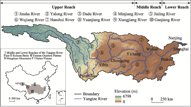
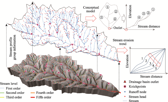
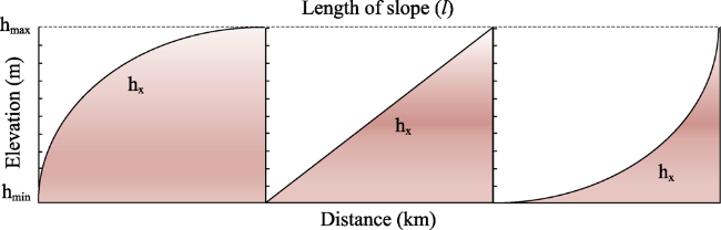
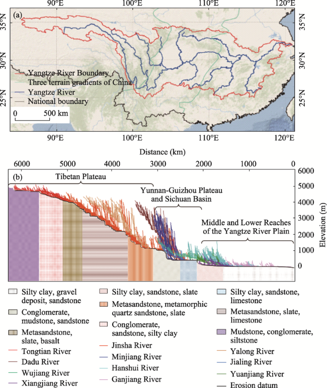
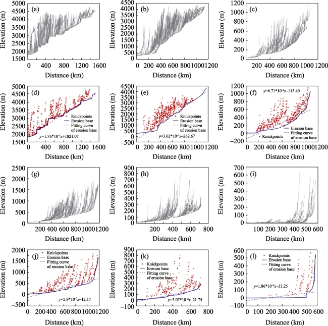
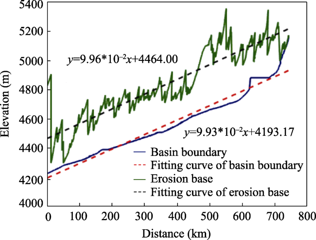
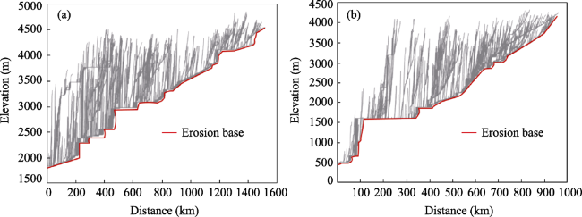
Therefore, the erosion base presents the characteristics of ladder shape for a long time (Figures 5a and 5d*The Minjiang River Basin is located in the eastern margin of the Tibetan Plateau, which is at the junction of the Minshan Uplift Belt, Longmenshan Structural Belt and Songpan-Ganzi Fold Belt. The Minjiang River originates from the hinterland of the plateau on the west side of the Minshan Uplift Belt. The main stream flows through the Longmenshan Structural Belt from north to south, intersects with three major tributaries, the Heishui River, Zagunao River and Yuxi River, and finally joins the Sichuan Basin. The Minjiang River spans the first and second topographic steps in China, and the height difference within the basin is great, reaching 3560 m. The uplift of the Tibetan Plateau provides topographic conditions for the evolution of modern glaciers in the upper reaches of the Minjiang River. The carrying capacity of runoff is poor and the stream fall is relatively small. In the middle and lower reaches of the Minjiang River, due to the long-term deep cutting of the Minjiang River, the stream erosion is strong and the elevation drops of streams are large (Kirby
et al.,
2000*Therefore, the overall stream profile clusters of the Minjiang River have a large drop, among which the elevation drops in the middle and lower reaches are higher than those of the upstream profiles (Figures 5b and 5e*The Yuanjiang River originates from the Yunnan-Guizhou Plateau. The upper reaches of the Yuanjiang River are composed of many alpine gorges. In the middle reaches of the Yuanjiang River, the slopes of the streams are gentle. Hilly mountains are mixed with the distribution of canyons in this reach. The canyons from Qiancheng to Hongjiang, Huangshi Cave to Copper Bay have lengths of tens of kilometers. The evolution of streams here is limited by the topography of the gorge, so in the middle reaches of the Yuanjiang River, the length of streams is short and the elevation drops are small. The Yuanjiang River Basin is geographically located in a region with good structural stability, which spans two tectonic units: the Yangtze Platform and the South China Fold Belt. There is no obvious tectonic uplift of the erosion base, and streams tend to be balanced gradually due to self-adjustment (Zhan
et al.,
2015*The erosion base in stream profile clusters is a smooth curve (Figures 5c and 5f*The Hanshui River originates near the Qinling-Daba Mountains, and there are many canyons and basins along the coast. The middle reaches of the Yangtze River flow from Danjiangkou to Zhongxiang county, through the Southeast Hills, and finally flow into the Middle and Lower Reaches of the Yangtze River Plain. From the perspective of plate theory, the Hanshui River is located near the Dabashan Tectonic Belt and the southern margin of the Qinling Fold Belt. The Dabashan Tectonic Belt was formed by the collision between the Qinling microplate and the Yangtze plate in the Late Triassic. Located at the eastern edge of the Tibetan Plateau, it is affected by a tectonic stress stretching from west to east (Wang
et al.,
2007*Therefore, in response to the eastward growth of the Tibetan Plateau, the height difference of the Hanshui River from upstream to its outlet decreases gradually, and the number of the knickpoints decreases gradually, and the group morphology of the stream profile clusters shows that the stream elevation drops decrease gradually from the upstream to the downstream (Figures 5g and 5j*The Ganjiang River Basin has a mountainous and hilly landform pattern, and there is an important regional fault in the basin called Ganjiang River Fault Zone. The main fault of the Ganjiang River Fault Zone is concealed at the bottom of the Ganjiang River. In addition, there are a few secondary faults perpendicular to the direction of the Ganjiang River in the middle reaches of the river. Tributaries in this reach flow into the nearby basin along the valleys formed by the faults (Xu
et al.,
1987*Therefore, in the middle reaches of the Ganjiang River Basin, the stream network is relatively scarce and the elevation drops are low (Figures 5h and 5k*The middle and lower reaches of the Yangtze River are located on the Yangtze platform. The geological unit is stable and there are few geological activities. Therefore, the stream course as a whole is very gentle, the elevation drops are small, and the distribution of knickpoints is few (Chun
et al.,
2003*In addition, the knickpoints are concentrated near the stream head points. This is because this reach of the Yangtze River flows from hilly mountains to plains. In the mountainous area, the underlying surface is mostly composed of conglomerate, sandstone and silty clay. In comparison, the plain area, where the underlying surface is mostly composed of sandstone, river deposits and other materials, is prone to be eroded. Runoff flows from the mountains to the plain, and at the junctions, the streambed cuts down rapidly, forming locally distributed knickpoints. In the plain region, the stream slows down and the stream is dominated by accumulation, so that the basin boundary formed by the head points of the stream is almost completely parallel to the erosion base (Figures 5i and 5l).

