Research Articles

The Bo-Tai Line: Establishing the concepts of a balanced regional development line and a national development backbone

  • FANG Chuanglin , 1, 2
Expand
  • 1. Institute of Geographic Sciences and Natural Resources Research, CAS, Beijing 100101, China
  • 2. College of Resources and Environment, University of Chinese Academy of Sciences, Beijing 100049, China

Fang Chuanglin (1966-), specialized in urban geography, urban agglomeration development and the resource and environmental effects of urbanization. E-mail:

Received date: 2021-01-12

  Accepted date: 2021-04-06

  Online published: 2021-08-25

Supported by

Major Program of the National Natural Science Foundation of China(41590840)

Major Program of the National Natural Science Foundation of China(41590842)

Abstract

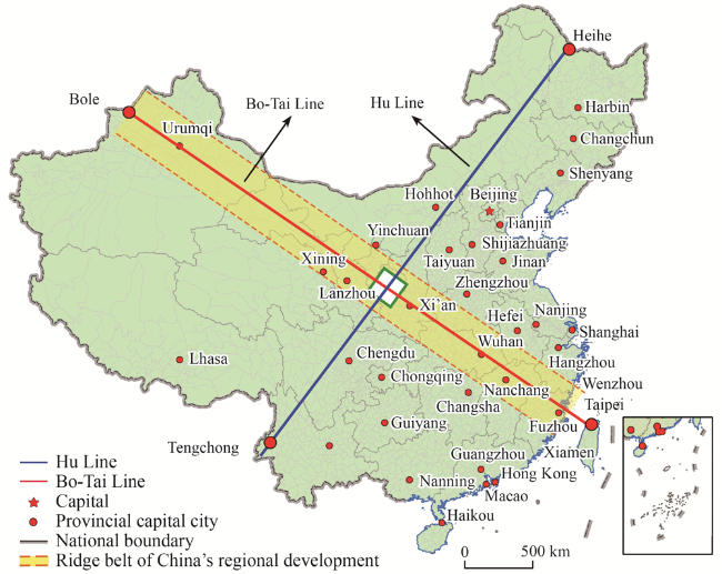
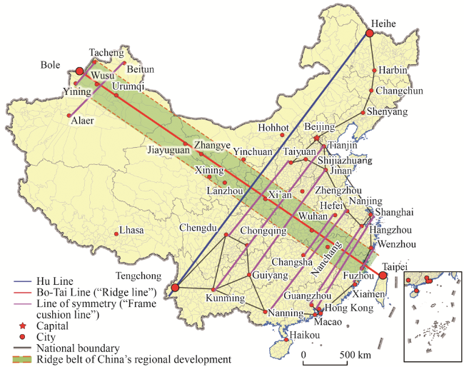
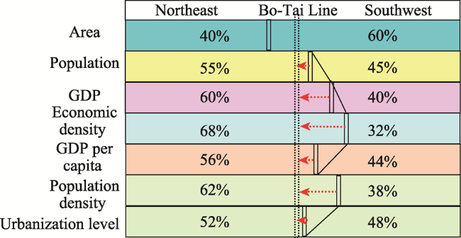
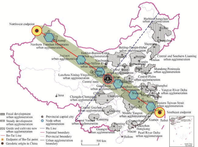
Promoting regional coordinated development strategy is one of the important strategies in the new period of China. Faced with the reality of unbalanced and insufficient regional development in China, it is objectively necessary to construct one or more main axes supporting the coordinated and balanced development of regions to become the identification line representing the pattern of coordinated regional development. The results show that the Bo-Tai line, the northwest-southeast axis connecting Bole of Xinjiang and Taipei of Taiwan, can be built into national development backbone line and regional balanced development line, just perpendicular to Hu Line. In 2016, the area of southwest half and northeast half of Bo-Tai Line accounts for 60%: 40%, while the population accounts for 45%: 55%, the economic aggregate accounts for 40%: 60%, the per capita GDP ratio accounts for 44%: 56%, the population density ratio accounts for 38%: 62%, the economic density ratio accounts for 32%: 68%, and the urbanization level ratio accounts for 48%: 52%. The main average indicators are gradually tending to balanced development pattern. Further analysis shows that Bo-Tai Line is a strategic shoulder pole connecting two core zones of “the Belt and Road”, and is the peaceful reunification line of China’s national tranquility and Taiwan’s return. Bo-Tai Line is also a solid line supported and connected by comprehensive transportation channels and a Pipa type symmetrical line for the development of cities and urban agglomerations. It is the backbone of the two-way opening up and the linkage development line between land and sea. It is also an important dividing line that promotes the coordinated development of the eastern, central and western regions, and addresses the imbalance and inadequacy of regional development. Bo-Tai Line plays an irreplaceable strategic role in promoting the coordinated and balanced regional development. It is suggested that the construction of Bo-Tai Line should be included in the national development strategy, and the development strategic plan of Bo-Tai Line should be formulated to fully release the multiple potential functions. We should build three strategic support points: the northwest endpoint, the central strategic node and the southeast endpoint; carry out a comprehensive scientific investigation of the Bo-Tai Line, and strengthen the scientific cognition and publicity; promote China’s development in a higher- level, higher-quality, more coordinated, safer and more civilized direction. Let Chinese know about the Bo-Tai Line, let the world know about the Bo-Tai Line, and let the Bo-Tai Line truly become the backbone of the great rejuvenation of the Chinese nation.

Cite this article

FANG Chuanglin . The Bo-Tai Line: Establishing the concepts of a balanced regional development line and a national development backbone[J]. Journal of Geographical Sciences, 2021 , 31(6) : 839 -858 . DOI: 10.1007/s11442-021-1874-4

1 Proposal of a balanced regional development line and creation of the Bo-Tai Line in China

1.1 Proposal of a balanced regional development line in China

China’s regional coordinated development strategy is one of its major national development strategies. Promoting regional coordinated and balanced development requires one or more major axes to support coordinated and balanced development of regions, which can become symbolic lines that characterize patterns of balanced regional development. The balanced regional development line in this study is a strategy for promoting coordinated and balanced development across China. Essentially, it is a strategic major axis that supports relatively balanced national economic and social development, which can evolve into the backbone of national development in the future. Through the balancing and radial effects of this balanced development axis, China will be urged toward a more coordinated, safer, and more civilized development path. Following a thorough examination of China’s regional development, it has been ascertained that China’s main geographical boundaries include geographical population distribution boundaries (Hu, 1935), topographical “step” boundaries, other topographical boundaries, climate boundaries, river boundaries, natural region boundaries, agricultural activity boundaries, administrative region boundaries and comprehensive geographical boundaries. Of these, the well-known Hu Huanyong Line (also known as Heihe-Tengchong Line, hereinafter Hu Line) represents a dividing line of China’s population geography (Hu, 1990). The first president of the Chinese Geological Society, Zhang Xiangwen, proposed as early as 1908 a north-south dividing line in China (known as the Qinling-Huaihe Line), which divided China’s north and south based on physical geography (Gong, 1994; Zheng, 2008; Zhang, 2012). None of these natural and human geography boundaries indicate the degree of balance in China’s regional development. Through repeated calculations, this author has found that the Bole-Taipei Line (hereinafter referred to as “Bo-Tai Line”), which connects the city of Bole in Xinjiang with Taipei in Taiwan in a northwest-to-southeast direction can be used as a dividing line for balanced development of China’s regions. National prosperity and territorial integrity require this line, and the great rejuvenation of the Chinese nation needs this line even more. Creating this balanced development line is an important measure for implementing the “Opinions on Establishing More Effective New Mechanisms for Regional Coordinated Development” issued by the Central Committee of the Communist Party of China and the State Council on November 18, 2018. It will effectively push China’s regional coordinated development to a new stage of development and will be of profound strategic significance for gradually solving the real-life problems of unbalanced and insufficient regional development, thereby improving the level and quality of coordinated regional development and helping to build a beautiful China and a strong modern socialist country (Fang, 2019).

1.2 The composition and direction of the Bo-Tai Line

The Bo-Tai Line refers to a straight line that runs northwest-to-southeast across China starting from the city of Bole in the Xinjiang Uygur Autonomous Region and extending southeast to Taipei in Taiwan. The part of the country that lies to the southwest of the line includes the whole of Tibet, Qinghai, Sichuan, Chongqing, Yunnan, Guizhou, Guangxi, Guangdong, Hunan, Fujian, Hainan, Taiwan, Hong Kong and Macau. It also includes the following parts of provinces and autonomous regions: Ili Kazakh Autonomous Prefecture, Urumqi, Bortala Mongolian Autonomous Prefecture, Kizilsu Kyrgyz Autonomous Prefecture, Bayingolon Mongol Autonomous Prefecture, the southern part of Changji Hui Autonomous Prefecture, Turpan, Aksu Prefecture, Kashgar Prefecture and Hotan Prefecture in Xinjiang; southwest Jiuquan, Zhangye, Wuwei, Lanzhou, Baiyin, Dingxi, Tianshui, Linxia, Gannan and Longnan in Gansu Province; Xi’an, Baoji, Hanzhong and Ankang in Shaanxi Province; Wuhan, Xianning, Shiyan and Enshi in Hubei Province; and Nanchang, Fuzhou, Xinyu, Yichun, Ji’an and Ganzhou in Jiangxi Province. The total land area southwest of the Bo-Tai Line is 5.6 million km2, accounting for 58.7% of China’s total land area. The remaining 41.3% of national land area lies northeast of the Bo-Tai Line (Figure 1).
Figure 1 Schematic diagram of the Bo-Tai Line for balanced regional development
The Bo-Tai Line and the Hu Line intersect perpendicularly at Zhenyuan County, Qingyang in Gansu Province, which borders Qingyang and Pingliang in Gansu as well as Xianyang and Baoji in Shaanxi. The point at which the two lines intersect perpendicularly is China’s geodetic origin point (Figure 2)1(1The geodetic origin point — also known as the geodetic datum point — is usually a relatively central point selected as the origin of a national geodetic network, from which astronomical longitude and latitude and astronomical azimuths to other points are measured with high precision. Using the “reference ellipsoid” positioning method it is possible to obtain latitude and longitude, altitude, and the azimuth angle to another point. These data are called “geodetic datum data.” The geodetic origin of the People’s Republic of China is located in Beiliu Village, Yongle Town, Jingyang County, Xianyang City, Shaanxi Province. It is the starting point and datum point of China’s latitude and longitude and also the starting point of the national geodetic coordinate system. It was established by the State Bureau of Surveying and Mapping in 1977 and completed and commissioned in 1978.). It is also one of the birthplaces of Chinese civilization. This intersection is of irreplaceable strategic significance in realizing the Chinese Dream of the great rejuvenation of the Chinese nation. In the context of China achieving balanced regional economic development, the land areas on both sides of the Bo-Tai Line and major economic indicators are roughly equal to each other, with the two sides relatively balanced. It is an important boundary for encouraging China to achieve balanced and coordinated regional development in the future, and it is the strategic backbone of China’s future development.
Figure 2 China’s geodetic origin point

1.3 The Bo-Tai Line and Hu Line

Looking at the direction of the Bo-Tai Line, it can be seen that it is perpendicular to the Hu Line and also to the northwest “Three Water Lines” proposed by academician Deng Mingjiang (Deng, 2019). The Hu Line, which runs perpendicular to the Bo-Tai Line, is an important geographical boundary and a line demarcating China’s demographic imbalance (Guoet al., 2016). It is an important boundary line for natural geography and the ecological environment (roughly the boundary line between the second and third “steps” of China’s topography, the boundary between semi-arid and semi-humid regions, the boundary of an annual average temperature of 12‒13 ℃, and other rigid constraints) (Lu et al., 2019); a boundary between national major function zones and national ecological function zones (more than 91% of optimized development zones and key development zones are concentrated southeast of the line, and more than 80% of national key ecological function zones are concentrated northwest of the line); the boundary between major areas of China’s new type of urbanization and non-major function zones (more than 95% of China’s new urbanization function zone urban clusters, more than 83% of new urbanization pilot areas, all national central cities, more than 90% of municipal cities, and 95% of designated towns are concentrated southeast of the line) (Fanget al., 2018); and the dividing line of China’s uneven regional development.
Using hyperspectral remote sensing and GIS technology to scientifically identify changes in various natural and human elements in the areas southeast and northwest of the Hu Line in the past 66 years from 1950 to 2016, it was found that the Hu Line is an important composite function line (Wu, 2001). It was determined that the northwest part is, in general, too “low” and the southeast half is too “high”. Although the land areas of both sides of the Hu Line are approximately similar, the population ratio has long been 5%:95%, the fixed asset investment ratio has long been 5%:95%, the ratio of utilized foreign investment has long been 4%:96%, the ratio of electricity consumption has long been 8%:92%, and local fiscal revenue ratio has long been 4%:96%. All of this indicates a totally unbalanced pattern in which “one side is very high, and the other side is very low” (Ding and He, 2015). This makes it a line demarcating China's unbalanced and insufficient economic and social development. This pattern will take a long time to change due to natural constraints; therefore, it is unable to serve as the national development backbone or a line of balanced regional development.
The Bo-Tai Line and the Hu Line divide China’s territory into quadrants: the first quadrant is northeast China, the second is southwest China, the third is northwest China and the Tibetan Plateau, and the fourth is the northern part of northern Xinjiang and Inner Mongolia (the fourth quadrant is the smallest by land area). Future regional development must gradually achieve China’s regional coordinated and balanced development goals through cooperation between the four quadrants and between cities in various regions within the quadrants, as well as using macro-strategic methods such as north China driving the northeast, south China driving the southwest, and special policies for Xinjiang and Tibet.

1.4 The physical and human geography of the Bo-Tai Line

From the southeast to the northwest along the Bo-Tai Line, China’s terrain gradually rises and its altitude gradually increases, average temperatures gradually decrease, average precipitation decreases, climate zones gradually change from humid and semi-humid to arid and semi-arid, temperature zones gradually change from tropical and subtropical to temperate, climate types gradually change from tropical and subtropical monsoon climates to a temperate continental climate or temperate arid climate, the natural landscape gradually changes from a forest landscape to a grassland landscape and then to desert landscape, population gradually changes from dense and relatively dense to sparse, ethnicity gradually changes from concentrations of Han people to concentrations of ethnic minorities, economic development gradually shifts from developed areas and moderately developed areas to underdeveloped areas, and the degree of openness gradually changes from a high degree to a medium or low degree. It can be seen, then, that the Bo-Tai Line runs not only through the eastern, central and western regions of China, but also connects the northern and southern regions of China. Conducting research on this line can provide an opportunity to find a new way of transcending the Hu Line and narrowing the development gap between China’s eastern and western regions.

2 The Bo-Tai Line as a line of balanced regional development

2.1 Land area on either side of the Bo-Tai Line

Based on preliminary calculations, the part of the country that lies southwest of the Bo-Tai Line covers an area of 5.6 million km2, accounting for 58.7% of China’s total land area, and the part that is northeast of the line accounts for 41.3% of China’s land area. The part of China that is southeast of the Hu Line accounts for 56.6% of China’s land area, and the northwest part accounts for 43.4%. This analysis indicates that the proportions of land area on either side of the Bo-Tai Line and the Hu Line are basically the same, at a ratio of roughly 6:4 (Table 1).
Table 1 Ratios of land area on either side of the Bo-Tai Line and Hu Line
Line name Side name Area (106 km2) Proportion to China’s total land area (%) Ratio of land area
on both sides
Bo-Tai Line Northeast 3.96 41.3 40:60
Southwest 5.64 58.7
Hu Line Northwest 4.17 43.4 40:60
Southeast 5.44 56.6
China 9.60 100.0

2.2 Proportions of population on either side of the Bo-Tai Line

An analysis of permanent population shows that from 1960 to 2016 the average ratio of China’s permanent population on the southwest and northeast sides of the Bo-Tai Line was 45%:55%, with an equal development trend (Table 2). The ratio of populations on either side was 44%:56% in 1960, 45%:55% in 1982, 46%:54% by 2000, and 46.06%:53.94% in 2016. There was a slight increase southwest of the line and a slight drop northeast of it (Figure 3). During the 56 years from 1960 to 2016, the proportion of the population southwest of the line increased at an average annual rate of 0.09%, with an average annual increase of 0.04 percentage points. The ratio may evolve to become balanced at 50:50 in the future.
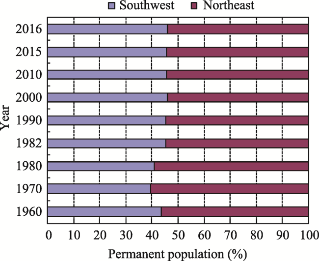
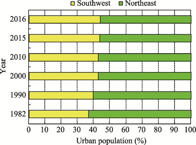
Table 2 Total population and urban population on either side of the Bo-Tai Line, 1960-2016
Year Total permanent
population (106)
Percentage of total permanent population (%) Urban population (106) Percentage of urban population (%)
Southwest Northeast Southwest Northeast Southwest Northeast Southwest Northeast
1960 289.99 372.08 43.80 56.20
1970 330.67 499.24 39.84 60.16
1980 403.86 583.19 40.92 59.08
1982 454.44 549.08 45.28 54.72 76.06 130.33 36.85 63.15
1990 513.86 616.65 45.45 54.55 117.33 178.80 39.62 60.38
2000 574.00 668.64 46.19 53.81 196.05 262.76 42.73 57.27
2010 609.92 722.89 45.76 54.24 287.68 382.33 42.94 57.06
2015 628.14 742.75 45.82 54.18 336.89 434.47 43.67 56.33
2016 641.22 7509.17 46.06 53.94 347.45 441.65 44.03 55.97
Average percentage (%) Increase Decrease 44.55 55.45 Increase Decrease 41.64 58.36

Notes: (1) In the table, the total population figures for 1982, 1990, 2000 and 2010 are based on census data from those years or 1% sampling statistical caliber data, mainly based on county data, with counties that straddle the line determined to be on the side of their county seat. The total population figures for the other years is based on statistical yearbook data. (2) Before 2000, total population data is used, and after 2000, total permanent population data is used. (3) The statistics in this table exclude Hong Kong, Macao and Taiwan.

Figure 3 Change in total population on either side of the Bo-Tai Line
Analysis of the proportions of the urban population on either side of the Bo-Tai Line shows that in the 34 years from 1982 to 2016 the average ratio for the areas southwest and northeast of the line was 42%:58%, with a consistent development trend (Table 2). In 1982, the urban population ratio was 37%:63%; in 1990, it became 40%:60%; in 2000, it was 43%:57%; and in 2016, it was 44%:56% (Figure 4). Thus, there was a slight increase in the proportion of southwest of the line and a slight decrease northeast of the line. In the 34 years from 1982 to 2016, the proportion of the urban population living southwest of the line increased at an average annual rate of 0.53%, with an average annual increase of 0.21 percentage points. The ratio may become balanced at 50:50 in the future.
Figure 4 Change in urban population either side of the Bo-Tai Line
Looking at the proportions of permanent residents living southeast and northwest of the Hu Line, based on the data from five censuses in 1953, 1982, 1990, 2000 and 2010 and estimated data from a 1% population sample survey in 2015, it can be seen that in the 62 years from 1953 to 2015, the total population of the Chinese mainland increased from 602 million to 1.37 billion (excluding active military personnel). The population southeast of the Hu Line increased from 571 million to 1.28 billion, while the population northwest of the line increased from 31 million to 87 million. The population ratio of the southeastern part to the northwestern part was 94%:6% and remained relatively stable (Qi et al., 2015). In this respect, the Hu Line has been relatively consistent (Huang and Yang, 2012; Chen, 2016; Wang and Deng, 2016). There have been slow changes, however. From 1953 to 2015, the proportion of the population living northwest of the Hu Line increased at an annual average rate of 0.3%.

2.3 GDP either side of the Bo-Tai Line

From an analysis of the proportions of GDP from 1960 to 2016, it can be seen that the areas southwest and northeast of the Bo-Tai Line had an average ratio of 40%:60% during the 56-year study period, with both sides maintaining an equal development trend (Table 3). In 1960, the GDP ratio was roughly 30%:70%. By 1982, it had changed slightly to 33%:67%. By 2000, it had changed again to 39%:61%. By 2016, the ratio had changed further to 40%:60% (Figure 5). This shows a slight increase in the southwest part and a slight decrease in the northeast. From 1960 to 2016, the share of GDP at current prices of the area southwest of the line increased at an average annual rate of 0.51%, with an average annual increase of 0.17 percentage points. The ratio may become balanced at 50:50 in the future.
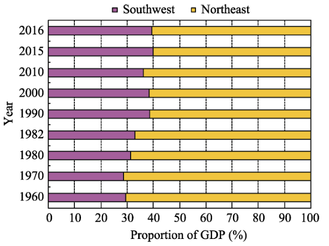
Table 3 Changes in GDP on either side of the Bo-Tai Line, 1960-2016
Year Southwest Northeast
GDP (109 yuan) Percentage (%) GDP (109 yuan) Percentage (%)
1960 43.26 29.69 102.44 70.31
1970 64.81 28.77 160.46 71.23
1980 144.63 31.53 314.13 68.47
1982 178.0 33.13 359.3 66.87
1990 731.1 38.74 1156.2 61.26
2000 3861.7 38.51 6166.3 61.49
2010 15058.6 36.46 26244.4 63.54
2015 27407.9 39.98 41142.6 60.02
2016 29365.6 39.46 45047.2 60.54

Notes: GDP uses current year values; statistics in this table do not include Hong Kong, Macao and Taiwan.

Figure 5 Changing proportions of economic output on either of the Bo-Tai Line
An analysis of the proportions of total economic output either side of the Hu Line in the 56 years from 1960 to 2016 shows that the ratio of GDP in the areas southeast and northwest of the Hu Line remained at around 94.93%:5.07% (Table 4). The percentage change in 56 years was only 1.84%, as the GDP growth rates of the southeast and northwest parts grew at very similar rates of 11.16% and 11.86%, respectively. This approximate ratio will be maintained for a long time in the future, so the imbalance in economic development on both sides will exist for a long time.
Table 4 Change in gross economic output either side of the Hu Line, 1960-2016 (%)
Year 1960 1970 1980 1990 2000 2010 2016 Change of proportion
Southeast 93.96 95.21 94.90 94.87 95.76 94.07 94.41 Slight decrease by 1.84%
Northwest 6.04 4.79 5.10 5.13 4.24 5.93 5.59 Slight increase by 1.84%
Ratio 94:6 95:5 95:5 95:5 96:4 94:6 94:6 Basically stable

2.4 GDP per capita and economic density on either side of the Bo-Tai Line

Analysis of GDP per capita data for both sides of the Bo-Tai Line shows that the ratio changed from 0.54:1 to 0.76:1 between 1960 and 2016, which indicates a balanced development trend (Table 5). In 1960, the ratio of GDP per capita of the two sides was 0.54:1, which changed slightly to 0.66:1 in 1980. In 2000 it was slightly changed again at 0.73:1, and in 2016 the ratio changed further to 0.76:1, when GDP per capita was 45,797 yuan in the southwest and 59,990 yuan in the northeast, with the gap gradually narrowing. This indicates that GDP per capita southwest of the Bo-Tai Line rose continuously, gradually approaching balanced development with GDP per capita in the northeast. During the 56 years from 1960 to 2016, the gap in GDP per capita between the two sides of the line narrowed at an average annual rate of 0.61%, and the ratio shrunk at an average annual rate of 0.0039 percentage points. A balanced development ratio of 1:1 may be achieved in the future.
Table 5 Changes in average economic indicators on either side of the Bo-Tai Line, 1960-2016
Year GDP per capita (yuan) Population density (people/km2) Economic density (yuan/km2)
Southwest Northeast Ratio of SW to NE Southwest Northeast Ratio of SW to NE Southwest Northeast Ratio of SW to NE
1960 149 275 0.54:1 51.46 93.84 0.55:1 0.77 2.58 0.30:1
1970 196 321 0.61:1 58.68 125.91 0.47:1 1.15 4.05 0.28:1
1980 358 539 0.66:1 71.67 147.09 0.49:1 2.57 7.92 0.32:1
1982 392 654 0.60:1 80.65 138.48 0.58:1 3.16 9.06 0.35:1
1990 1423 1875 0.76:1 91.19 155.52 0.59:1 12.97 29.16 0.44:1
2000 6728 9222 0.73:1 101.86 168.64 0.60:1 68.53 155.52 0.44:1
2010 24689 36305 0.68:1 108.24 182.32 0.59:1 267.23 661.90 0.40:1
2015 43633 55392 0.79:1 111.47 187.33 0.60:1 486.39 1037.64 0.47:1
2016 45797 59990 0.76:1 113.79 189.39 0.60:1 521.13 1136.12 0.46:1
Looking at the economic density of both sides of the Bo-Tai Line, it can be seen that the ratio of the southwest part to the northeast part changed from 0.3:1 to 0.46:1 from 1960 to 2016. As such, the gap in economic density between the two sides gradually narrowed, with a trend toward balanced development (Table 5). In 1960, economic density was 7,700 yuan/km2 in the southwest and 25,800 yuan/km2 in the northeast, giving a ratio of 0.77:1. By 1990, the ratio had changed slightly to 0.44:1. By 2016, economic density was 5.21 million yuan/km2 in the southwest and 11.36 million yuan/km2 in the northeast, changing the ratio further to 0.46:1. This indicates that economic density southwest of the line is increasing and gradually approaching balanced development in the northeast. In the 56 years from 1960 to 2016, the gap in economic density between the two sides of the Bo-Tai Line shrunk at an average annual rate of 0.76%, and the ratio fell at an average annual rate of 0.0029 percentage points. This may change to a 1:1 balanced development pattern in the future.

2.5 Population density and urbanization levels on either side of the Bo-Tai Line

Analysis of population density on both sides of the Bo-Tai Line from 1960 to 2016 shows that the ratio of southwest to northeast changed from 0.55:1 to 0.6:1. The population density gap between the two sides gradually narrowed, trending toward balanced development (Table 6 and Figure 6). In 1960, population density was 51.46 people/km2 on the southwest side of the line and 91.84 people/km2 on the northeast side, giving a ratio of approximately 0.55:1. By 1990, the population density ratio had changed slightly to 0.59:1. By 2016, population density on the southwest side was 113.79 people/km2, and on the northeast side it was 189.39 people/km2, changing the ratio further to 0.6:1. This indicates that population density on the southwest side is increasing and gradually approaching balanced development with the northeast side. From 1960 to 2016, the population density gap between the southwest side of the line and the northeast side shrunk at an average annual rate of 0.15%, at an average annual rate of 0.0008 percentage points. It may evolve into a 1:1 balanced development pattern in the future.
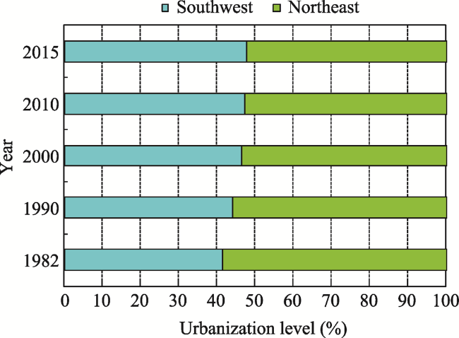
Table 6 Change in urbanization on either side of the Bo-Tai Line, 1960-2016 (%)
Year Southwest Northeast Ratio (SW to NE)
1982 16.74 23.74 0.71:1
1990 22.83 29.00 0.79:1
2000 34.16 39.30 0.87:1
2010 47.17 52.89 0.89:1
2015 53.63 58.49 0.92:1
Figure 6 Change in urbanization on either side of the Bo-Tai Line

3 The basic function and strategic role of the Bo-Tai Line

The Bo-Tai Line is a strategic line connecting the dual core areas of the Belt and Road Initiative (BRI). It is a line of national peace and reunification. It is a physical line that supports and connects comprehensive transportation channels and has intersecting lines of symmetry through national cities and urban agglomerations. The Bo-Tai Line forms the backbone of bidirectional opening up to the outside world, and it is a line of connection for mutual development by sea and land. It is also an important dividing line for promoting the coordinated development of China’s eastern, central and western regions and for solving the problems of uneven and insufficient regional development.

3.1 Strategic line connecting the dual core areas of the Belt and Road Initiative

The Bo-Tai Line connects the core area of the Silk Road Economic Belt (Xinjiang) with the core area of the 21st-Century Maritime Silk Road (Fujian), like a giant pole that “carries” the two core areas. It plays a very important leading role in the “Vision and Actions on Jointly Building the Silk Road Economic Belt and 21st-Century Maritime Silk Road.” This line further promotes the Silk Road spirit of “peaceful cooperation, openness and inclusiveness, mutual learning and mutual benefit,” and it firmly shoulders the important role of linking the prosperity and development of countries along the routes. It promotes the orderly and free flow of economic factors, the efficient allocation of resources and in-depth market integration in countries and regions along the BRI. It encourages countries along the BRI to coordinate their economic policies and carry out high-level as well as wider and deeper regional cooperation, as well as to jointly create an open, inclusive and balanced regional economic cooperation corridor. The Bo-Tai Line reflects the targets of co-creating and sharing policy communication, facility connectivity, unimpeded trade, financial connectivity and people-to-people contact, as set out in the “Vision and Actions on Jointly Building the Silk Road Economic Belt and 21st-Century Maritime Silk Road.”

3.2 A line of national peace and reunification

The Bo-Tai Line connects Bole in Xinjiang in northwest China to Taipei in Taiwan in China’s southeast. The western end is a key area for achieving the general goals of social stability and long-term peace in Xinjiang, and the eastern end, in Taiwan is a key area for achieving the goal of peaceful reunification of China. The Bo-Tai Line provides important strategic support for realizing Taiwan’s return to China and social stability and long-term peace in Xinjiang. It is conducive to further strengthening the Chinese nation’s high sense of responsibility and strong patriotism in defending the territorial integrity of the motherland. It is conducive to strengthening Taiwan’s position as an indispensable part of the ridgeline in China’s national development, to deepening cross-Strait economic cooperation, to expanding areas of cross-Strait cooperation, to enhancing the wellbeing of compatriots on both sides of the Strait, and to bolstering and promoting the peaceful development of cross-Strait relations. It lays a solid foundation for the realization of the Chinese Dream of the great rejuvenation of the Chinese nation. The construction of the Bo-Tai Line will surely play an important role in national strategic arrangements by “stabilizing the northwest and managing the southeast.”

3.3 Lines of symmetry for developing national cities and urban agglomerations

The symmetrical lines that run across the Bo-Tai Line, which serves as a territorial axis, forms lute-shaped ridgelines composed of 10 symmetrical urban axes of varying lengths and five pairs of urban agglomeration symmetrical axes. The 10 symmetrical urban axes, which run from northwest to southeast, are the Tacheng-Yining axis, the Beitun-Alar axis, the Chengdu-Taiyuan axis, the Kunming-Chongqing-Zhengzhou-Tianjin axis, the Guiyang-Jinan axis, the Changsha-Hefei symmetry axis, the Nanning-Nanjing axis, the Guangzhou-Hangzhou axis, the Shenzhen-Shanghai axis and the Xiamen-Wenzhou axis. These axes constitute 10 “ribs” of national development ( Figure 7). The central ridgeline and the 10 “ribs” of the Bo-Tai Line make up a lute-shaped structure of national development that dominate the arteries of national development and will play the strongest role in the great rejuvenation of the Chinese nation and support the realization of the Chinese Dream. In future regional development, the construction of these 10 symmetrical axes and the node cities on the axis is vital for narrowing the development gap between east and west and enhancing China’s international competitiveness. As such, it has far-reaching strategic significance.
Figure 7 Lute-shaped lines of symmetry of the Bo-Tai Line
The five pairs of symmetrical urban agglomerations spanning the Bo-Tai Line are the Chengdu & Chongqing-Beijing, Tianjin & Hebei symmetrical agglomerations, the Yangtze River Delta-Pearl River Delta symmetrical agglomerations, the Central Guizhou-Shandong Peninsula symmetrical agglomerations, the Central Yunnan-Central and Southern Liaoning symmetrical agglomerations, and the Beibu Gulf-Jianghuai symmetrical agglomerations. Of these, the Chengdu & Chongqing-Beijing, Tianjin & Hebei symmetrical agglomerations and the Yangtze River Delta-Pearl River Delta symmetrical agglomerations are the “double hearts and double lungs” of the Bo-Tai Line.

3.4 A physical line that supports and connects comprehensive transportation channels

While the Hu Line is a virtual line that lacks the support of continuous smooth and convenient transport arteries, the Bo-Tai Line is a cluster of integrated transportation channels made up of physical lines such as high-speed rail, other railways, highways, public roads and oil and gas pipelines. These include the Lanzhou-Xinjiang high-speed railway and ordinary railway, the Xi’an-Lanzhou high-speed railway and ordinary railway, the Xi’an-Wuhan- Fuzhou high-speed railway and ordinary railway, the Lanzhou-Xinjiang expressway and ordinary road, the Xi’an-Lanzhou expressway and ordinary road, the Xi’an-Wuhan-Fuzhou expressway and ordinary road, as well as the West-to-East Gas Pipeline. These high-speed railways and expressways are closely connected to China’s “four vertical and four horizontal” high-speed railway network and “five vertical and five horizontal” highway network, forming a comprehensive transportation network connecting China’s east and west and its north and south, which guarantees the normal operation of the national economy and the social development system. This physical line of transportation is on the route of the China-Europe Railway Express, which plays an important role in ensuring the transportation of goods to Central Asia and Europe, as it travels westward.

3.5 A backbone of bidirectional opening-up and a line connecting development by sea and land

The Bo-Tai Line is located on the main route of the westerly Silk Road. As a land port to the outside world and based on the strategy of “going west,” it connects China to Central and West Asia and on to Europe. To the east, it connects China to countries and regions in Southeast Asia, South Asia and the Pacific Rim, as well as the Americas and Oceania, via coastal ports along the 21st Century Maritime Silk Road. The Bo-Tai Line can comprehensively promote bidirectional opening up to the outside world, deepen international cooperation in production capacity and equipment manufacturing, promote the orderly flow of domestic and international factors of production, efficiently allocate resources, deeply integrate markets, improve utilization of foreign capital and foreign investment, cultivate new international competitive advantages, and form a new pattern of all-round opening-up from east to west. The construction of this backbone of bidirectional opening-up will play an important role in allowing China to participate in global economic governance, to promote an equal and fair international economic order, and to assume international responsibilities and obligations.
The Bo-Tai Line connects the arid areas of northwest China with the humid coastal areas of east China, forming a coordinated development line consisting of inland and coastal areas as well as internal and external links, which is conducive to the intensive development and utilization of land while continuously expanding the blue economy, rational development of marine resources, development of the marine economy, protection of the marine environment, and China’s development into a maritime power. By contrast, the Hu Line is a dividing line from China’s northeast territory to its southwest hinterland, and it does not incorporate China’s coastal areas.

3.6 A dividing line for solving uneven and insufficient development

The Bo-Tai Line spans the eastern, central and western regions of China and connects China’s different economic gradients. It is an important boundary linking China’s developed regions and underdeveloped regions. It is also an important zone for implementing policies on prioritizing development of China’s coastal regions, the rise of central China, and the large-scale development of the western region. This holds important strategic significance for narrowing the development gap between China’s east and west, allowing some areas to prosper first to drive the prosperity of other areas, and promoting the common development of developed and underdeveloped regions. The Bo-Tai Line traverses north and south China, connecting underdeveloped areas in northern China with developed areas in the south, giving it an important strategic role in narrowing the increasingly prominent gap between north and south. Promoting the Bo-Tai Line concept is conducive to exploring a new mechanism for regional links and coordinated development between developed and underdeveloped regions as well as to forming a new model of coordinated regional development characterized by effective overall planning, orderly competition, coordination on environmental issues, sharing and mutual benefit. It will also promote a transition from the current state of relatively balanced development on both sides of the Bo-Tai Line to a state of balanced development (Table 7, Figures 8 and 9). The Bo-Tai Line can be developed into a boundary that resolves unbalanced and inadequate development between the eastern, central and western regions, as well as north and south China, and it can act as a central axis for promoting coordinated regional development.
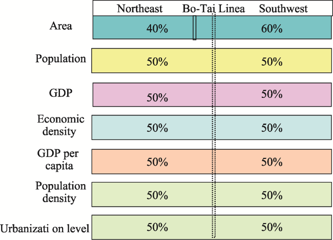
Table 7 Change in proportions of major economic and social indicators either side of the Bo-Tai Line
Unit of comparison 2016 development status Future balanced development Balanced development ratio (NE to SW)
Northeast Southwest Northeast Southwest
Area (%) 40 60 40 60 40:60
Population (%) 55 45 50 50 1:1
GDP (%) 60 40 50 50 1:1
GDP per capita (%) 56 44 50 50 1:1
Economic density (%) 68 32 50 50 1:1
Population density (%) 62 38 50 50 1:1
Urbanization level (%) 52 48 50 50 1:1
Figure 8 Current status and imbalance between the two sides of the Bo-Tai Line
Figure 9 Balanced development either side of the Bo-Tai Line

4 The basic concept of the Bo-Tai Line

The Bo-Tai Line has very important coordinating and balancing functions in China’s regional development, in which it can play a major strategic role. From northwest to southeast, the Bo-Tai Line passes through 10 provinces and autonomous regions, namely, Xinjiang, Gansu, Qinghai, Ningxia, Shaanxi, Hubei, Hunan, Jiangxi, Fujian and Taiwan. Many of them are old revolutionary base areas with backward economies. The five urban agglomerations (Tianshan North-Slope urban agglomeration, Lanzhou-Xining urban agglomeration, Guanzhong Plain urban agglomeration, Yangtze River Middle Reaches urban agglomeration, and Western Taiwan Strait urban agglomeration) that the Bo-Tai Line passes through, meanwhile, are China’s less developed or least developed urban agglomerations. In the future, it is necessary to improve the development of these urban agglomerations and promote the rapid rise of areas along the Bo-Tai Line. This is a very important strategy for reducing the development gap between China’s eastern, central and western regions, as well as the development gap between China’s north and south, and it is vital to promote more adequate and balanced regional economic development.

4.1 Incorporating the Bo-Tai Line in China’s 14th Five-Year Plan and regional development strategy with the support of urban agglomerations

Guided by the “Opinions on Establishing More Effective New Mechanisms for Regional Coordinated Development” issued by the Central Committee of the Communist Party of China and the State Council on November 18, 2018, there is a need to implement coordinated regional development strategies and incorporate the construction of the Bo-Tai Line into China’s coordinated regional development strategy, the outline of the 14th Five-Year Plan (2021-2025), the large-scale development strategy for China’s western region, and the national open border pilot zone. It is also necessary to formulate special supporting policies to give priority to the construction of the three strategic pivots at the northwest end, the central point and the southeast end of the Bo-Tai Line, and to promote development of the five urban agglomerations with relatively low development along the Bo-Tai Line (Fanget al., 2016; Wang and Deng, 2016). These five urban agglomerations will support the rapid rise of places along the Bo-Tai Line from low economic development areas by forming a “3+6” (three pivots and six urban agglomeration) spatial pattern. This spatial support pattern (Figure 10) will develop the Bo-Tai Line into a new growth belt and a high-quality development zone that promotes balanced regional development.
Figure 10 Spatial support pattern (“3+6”) of the Bo-Tai Line

4.2 Developing a plan for the Bo-Tai Line to realize its potential

To understand the strategic importance and practical urgency of developing the Bo-Tai Line, it is necessary to formulate a “Strategic Plan for the Development of the Bo-Tai Line” at the national level that clarifies the spatial scope, radial scope, development positioning, objectives, priorities, spatial layout and safeguards of the Bo-Tai Line. Through planning, it will be possible to fully unleash the multiple functions and huge potential of the Bo-Tai Line as a strategic line connecting the dual core areas of the BRI, a line of national peace and reunification, a line that connects comprehensive transportation channels, a backbone of bidirectional opening-up, a line connecting maritime and inland development, and a line for narrowing the gap in regional development to resolve inadequate and unbalanced regional development. It will also be possible to strengthen infrastructure construction, urban construction and the development of urban agglomerations on both sides of the Bo-Tai Line; to consolidate the balanced development ridgeline from Bole to Taipei, strengthen the 10 “ribs,” and build a supporting lute-shaped development framework, so as to support the Chinese Dream of the great rejuvenation of the Chinese nation.

4.3 Focusing on the three strategic pivots to enhance the Bo-Tai Line in national development

It is necessary to focus on the construction of the three strategically important pivot points of the Bo-Tai Line and cultivate them into new growth poles that support national development. The first is the northwest end of the Bo-Tai line at Bole in Xinjiang and its surrounding area consisting of the cities of Alashankou, Khorgas, Yining, Shuanghe (Fifth Division of the Xinjiang Production and Construction Corps) and Kokdala (Fourth Division of the Xinjiang Production and Construction Corps). The second is the central point of the Bo-Tai Line where it intersects with the Hu Line, which is composed of the four cities of Qingyang and Pingliang in Gansu Province and Baoji and Xianyang in Shaanxi. The third is the southeast end of the Bo-Tai Line, which is composed of the two cities of Fuzhou in Fujian Province and Taipei in Taiwan.

4.3.1 Accelerating construction of the northwest end of the Bo-Tai Line to enhance its strategic position

In accordance with the development model of military and local government integration as well as internal and external links, development should be centered on Bole City and combined with development of Alashankou, Khorgas, Yining, Shuanghe and Kokdala to create a six-city Silk Road Economic Belt urban agglomeration, along with the development of the western side of the Tianshan North-Slope urban agglomeration, to make the six cities an important part of the Tianshan North-Slope urban agglomeration (Ji and Gao, 2012; Fang and Yu, 2017). The city of Bole borders the Republic of Kazakhstan to the north, so it is recommended to enhance Bole’s strategic position in the Silk Road Economic Belt and the Bo-Tai Line by formulating special policies to build it into a northern bridgehead of the balanced national development line and a national key open development pilot zone.

4.3.2 Accelerating construction of the central point of the Bo-Tai Line to establish a center of gravity for the national balanced regional development line

The Bo-Tai Line and the Hu Line intersect perpendicularly at Zhenyuan County, Qingyang City in Gansu Province. The greater area comprises the four cities of Qingyang and Pingliang in Gansu Province and Baoji and Xianyang in Shaanxi Province, which together constitute the strategic central point of the Bo-Tai Line. This zone covers an area of approximately 65,700 km2, with a total population of 12.9 million at the end of 2018 and GRP of about RMB 57.5 billion yuan. Historically, the zone has had good natural conditions and a strong cultural heritage as one of the cradles of Chinese civilization. It is where emperors established capitals and military strategists fought battles in the past. Today, it benefits from abundant natural resources and good transportation links. In addition, it is an old revolutionary base area and red revolutionary base area. Xianyang is China’s geodetic origin point; Qingyang is a sacred communist area, the birthplace of traditional Chinese medicine and a new energy capital; and Baoji is a major industrial town in western China, a high-end equipment manufacturing base, a new material R&D and production base and known as China’s Titanium Valley. On the whole, the area’s economy is slightly underdeveloped. In 2018, GDP per capita was 44,500 yuan, which is only 69% of the national average. However, it has a sound development foundation and considerable development potential, so it could be developed with the support of the State to become the center of gravity of China’s balanced regional development line.

4.3.3 Accelerating the development of the southeast end of the Bo-Tai Line to achieve national reunification

The southeast end of the Bo-Tai Line is composed of the two cities of Fuzhou in Fujian Province and Taipei in Taiwan Province. In the future, development of the Fuzhou metropolitan area and the Western Taiwan Strait urban agglomeration can serve as breakthrough points for promoting cross-Strait connections, encouraging mutual development and prosperity, realizing Taiwan’s swift return to the motherland and laying the foundation for completing the great cause of peaceful reunification of China.

4.4 Scientifically investigating and promoting awareness of the Bo-Tai Line

The Bo-Tai Line is a line of balanced regional development in China, a line of peaceful reunification, and a strategic line connecting the dual core areas of the Silk Road. There is still a lack of scientific awareness regarding the line, however, unlike the Hu Line, which is well understood by academia and the public. It is recommended, therefore, that the State conducts comprehensive scientific investigations on the Bo-Tai Line, to create landmark results that will support balanced and coordinated regional development in China. This is of vital importance for narrowing the development gap between China’s east and west, as well as north and south. It is also recommended that traditional and new media and other publicity methods are used to promote the importance, strategic status and multiple functions of the Bo-Tai Line. This will improve understanding of the Bo-Tai Line in China and abroad, ensuring that it becomes a line of balanced regional development that can genuinely support the great rejuvenation of the Chinese nation.

5 Conclusion and discussion

(1) The Bo-Tai Line, which runs perpendicular to the Hu Line, can reasonably be expected to become a line of balanced regional development in China and the backbone of national development in the future. This line of balanced regional development fits with China’s important strategy of promoting coordinated and balanced national development. The focus is on developing a strategic axis that supports relatively balanced development of China’s economy and society. Through the balancing and radial effects of this axis, the country is urged toward more coordinated, more secure and more civilized development. Calculations show that the ratio of land area on the southwest and northeast sides of the Bo-Tai Line is stable at 60%:40%, which is basically the same as the ratio for the Hu Line; the population ratio either side of the Bo-Tai Line has remained stable at 45%:55%, but it is evolving toward a 50%:50% balanced pattern; the proportions of GDP accounted for by either side of the Bo-Tai Line has stabilized at 40%:60%, but this is becoming balanced at 50%:50%; GDP per capita and economic density are gradually tending toward a 1:1 balanced development pattern, as are population density and level of urbanization.
(2) The Bo-Tai Line has an irreplaceable important strategic function and role in promoting coordinated and balanced development between China’s regions. The Bo-Tai Line is a strategic line connecting the dual core areas of the BRI. It is a line of peaceful unity for bringing tranquility and the return of Taiwan to China. It is a physical line supporting comprehensive transportation channels and a lute-shaped symmetrical pattern for the development of national cities and urban agglomerations. It is the backbone of bidirectional opening-up and a line connecting maritime and land-based development. It is also an important dividing line for promoting the coordinated development of the east, middle and west as well as the north and south regions and for solving the problem of unbalanced and insufficient regional development.
(3) The following are the recommendations of this study: to include development of the Bo-Tai Line in China’s national development strategy, incorporate it into the 14th Five-Year Plan and coordinated regional development strategy, and use urban agglomeration development to support the rapid ascension of the Bo-Tai Line; to formulate a strategic plan for the development of the Bo-Tai Line to realize its potential functions; to highlight development of the Bo-Tai Line’s northwest end, strategic central point and southeast end by including the northwest end in the construction of the Tianshan North Slope urban agglomeration, developing the strategic central point into the center of gravity of national balanced development and leveraging the southeast end to achieve the peaceful reunification of China; and to carry out a comprehensive scientific investigation of the Bo-Tai Line, so as to boost awareness and publicity of it. It is hoped that these measures will improve understanding of the Bo-Tai Line in China and abroad, ensuring that it becomes a line of balanced regional development that can genuinely support the great rejuvenation of the Chinese nation.
(4) The Bo-Tai Line is a balanced regional development line for China proposed by this author after a long period of reviewing China’s regional development map, thinking about China’s regional development strategy and conducting field investigations of areas along the line. It also provides another explanation of whether the Hu Line, which has come to the attention of academia and political circles, can be transcended. As the Hu Line cannot be directly transcended, a new approach can be taken to overcome it. The Bo-Tai Line is one such line that can be used to make a breakthrough and to rise above difficulties, as it is not subject to such rigid natural constraints. China needs this line for prosperity, national stability and territorial integrity, as well as for the great rejuvenation of the Chinese nation. Developing the Bo-Tai Line is an important measure for implementing the “Opinions on Establishing More Effective New Mechanisms for Regional Coordinated Development” issued by the Central Committee of the Communist Party of China and the State Council on November 18, 2018. It will effectively push China’s regional coordinated development to a new stage of advancement and gradually solve the real-life problems of unbalanced and insufficient regional development, thereby improving the level and quality of coordinated regional development.
(5) The scientific understanding of the Bo-Tai Line still requires improvement. The Bo-Tai Line outlined in this study constitutes only a superficial exploration based on this author’s understanding of the degree of balance in China’s regional development, but different scholars may produce different lines of division and interpretations. As a discovery of a type of balanced regional development, it will inevitably lead to disputes or objections, which is both normal and necessary. It will be necessary to provide scientific answers to some of the following important strategic questions related to national development in future: What kind of natural and human factors are driving the trend toward balance behind this phenomenon? How wide should the Bo-Tai Line be on either side? When should the Bo-Tai Line become the national line of balanced regional development? After the Bo-Tai Line becomes the balanced development line, will the inherent balance be broken and a new state of equilibrium appear? Will it cause the line of balanced regional development to shift with it? How can the balanced development zone set out here be developed? Can the Bo-Tai Line become the backbone of the national development strategy in the future? As a scientific researcher, I stand ready to listen to the opinions and criticisms of all parties, and I would be very happy to work with elders, teachers and colleagues who are interested in balanced regional development in China.

During the writing of this article, academician Qin Dahe, Academician Ye Danian, and researcher He Shujin from the Institute of Geographic Sciences and Natural Resources Research of the Chinese Academy of Sciences provided valuable suggestions. Three anonymous reviewers also repeatedly proposed pertinent and constructive suggestions. My colleague Qi Wei, postdoctoral fellow Liu Haimeng, and doctoral student Ren Yufei collected and sorted relevant data and prepared figures for this article. To all of them, I would like to express my sincere thanks.

[1]
Chen M X, Li Y, Gong Y H et al., 2016. The population distribution and trend of urbanization pattern on two sides of Hu Huanyong population line: A tentative response to Premier Li Keqiang. Acta Geographica Sinica, 71(2):179-193. (in Chinese)

[2]
Fang C L, Yu D L, 2017. Urban agglomeration: An evolving concept of an emerging phenomenon. Landscape and Urban Planning, 162:126-136.

DOI

[3]
Deng M J, 2019. “Three Water Lines” strategy: Its spatial patterns and effects on water resources allocation in northwest China. Acta Geographica Sinica, 73(7):1189-1203. (in Chinese)

[4]
Ding J H, He S J, 2015. China’s demographic geography and the future of urbanization: A symposium to commemorate the 80th anniversary of the discovery of the Hu Line was held in Shanghai. Acta Geographica Sinica, 70(12):2. (in Chinese)

[5]
Fang C L, 2019. Strategic thinking and spatial layout for the sustainable development of urban agglomeration in northern slope of Tianshan Mountains. Arid Land Geography, 42(1):1-9.

[6]
Fang C L, Bao C, Ma H T, 2016. China’s Urban Agglomeration Development Report 2016. Beijing: Science Press,12-17.

[7]
Fang C L, Wang Z B, Liu H M, 2019. Exploration on the theoretical basis and evaluation plan of Beautiful China construction. Acta Geographica Sinica, 74(4):619-632. (in Chinese)

[8]
Fang C L, Wang Z B, Ma H T, 2018. The theoretical cognition of the development law of China’s urban agglomeration and academic contribution. Acta Geographica Sinica, 73(4):651-665. (in Chinese)

[9]
Gong S S, 1994. The geographical boundary of the Qinling mountains and Huaihe river in Yugong. Journal of Hubei University (Philosophy and Social Science), 21(6):93-97. (in Chinese)

[10]
Guo H D, Wang X Y, Wu B F et al., 2016. Cognizing population density demarcative line (Hu-Line) based on space technology. Bulletin of Chinese Academy of Sciences, 31(12):1385-1394. (in Chinese)

[11]
Hu H Y, 1935. Population distribution in China: Statistical tables and density maps are attached. Acta Geographica Sinica, 2(2):33-74. (in Chinese)

[12]
Hu H Y, 1990. The distribution, regionalization and prospect of China’s population. Acta Geographica Sinica, 45(2):139-145. (in Chinese)

[13]
Huang Y X, Yang B, 2012. A study of environmental determinism from the perspective of “Hu Huanyong Line”. Journal of Yunnan Normal University (Philosophy and Social Sciences), 44(1):68-73. (in Chinese)

[14]
Ji J, Gao X L, 2012. Research on the industry development of urban agglomeration of Tianshan Mountains’ northern slope under the Belt and Road initiative. Arid Land Geography, 35(4):687-694. (in Chinese)

[15]
Lu D D, Wang Z, Feng Z M et al., 2016. Academic debates on Hu Huanyong population line. Geographical Research, 35(5):805-824. (in Chinese)

[16]
Qi W, Liu S H, Zhao M F, 2015. Study on the stability of Hu Line and different spatial patterns of population growth on its both sides. Acta Geographica Sinica, 70(4):551-566. (in Chinese)

[17]
Wang K Y, Deng Y, 2016. Can new urbanization break through the Hu Huanyong Line? Further discussion on the geographical connotations of the Hu Huanyong Line. Geographical Research, 35(5):825-835. (in Chinese)

[18]
Wu C J, 2001. Hu Huanyong’s contribution to the development of China’s geography. Human Geography, 16(5):1-4. (in Chinese)

[19]
Zhang J, Liu X N, Tan Z H et al., 2012. Mapping of the north-south demarcation zone in China based on GIS. Journal of Lanzhou University (Natural Sciences), 48(2):1-8. (in Chinese)

[20]
Zheng D, 2008. Research on Eco-geographic Regional Systems in China. Beijing: The Commercial Press,25-36.

Outlines

/