
Journal of Geographical Sciences >
Contrasting characteristics and origin of Danxia arched rock shelters in Zhejiang, China, and natural arches and bridges on the Colorado Plateau, USA
|
Tan Yufang (1990-), specialized in engineering geology and geohazard. E-mail: tanyufang@mail.cgs.gov.cn |
Received date: 2020-03-31
Accepted date: 2020-09-11
Online published: 2021-08-25
Supported by
National Natural Science Foundation of China(41372322)
The red beds in Zhejiang province of China host the highest concentration of Danxia arched rock shelters in the world, just as the Colorado Plateau in the western USA hosts the world’s largest concentration of natural arches and bridges. This study investigated the geological background of the arched rock shelters and compared them to the natural arches and bridges, based on field study and a literature review. It was found that Zhejiang arched rock shelters differ from Colorado Plateau natural arches and bridges in geometry and formation mechanism. Statistical geometric data on arch geometry shows that Danxia arched rock shelters in Zhejiang tend to be relatively flat. They are relatively low features with long spans, and great depth. The natural arches and bridges on the Colorado Plateau are similar to each other, but the bridges are larger than the arches. The geometric differences between the arched landforms could be attributed to their different geologic history and to their different formation mechanisms. The arched rock shelters in Zhejiang are formed by differential weathering between sandstone and conglomerate due to moisture-induced tensile stresses. In contrast, natural arches on the Colorado Plateau are closely related to the Salt Valley anticline, vertical tectonic fractures, and horizontal discontinuities in rock fins. The Colorado Plateau natural bridges were formed by river erosion.
TAN Yufang , LI Lihui , HUANG Beixiu . Contrasting characteristics and origin of Danxia arched rock shelters in Zhejiang, China, and natural arches and bridges on the Colorado Plateau, USA[J]. Journal of Geographical Sciences, 2021 , 31(6) : 802 -818 . DOI: 10.1007/s11442-021-1872-6
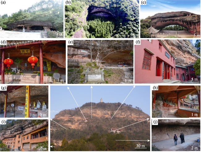
Figure 1 Photographs showing typical Danxia rock shelters (a. Meiyan with Taoist statues; b. Dafodong with a giant Buddha statue; c. A natural arch with giant Go board and black and white stone pieces under the arch; d. Zhongdong with Buddha statues of the monk Jigong; e. Canludong with three Taoist statues; f. Yujingdong with six Taoist statues; g. Ruixiadong with three Buddha statues of the monk Jigong; h. Baiyundong with hundreds of Buddha statues of the monk Jigong; i. Ziyundong serves as a Buddha convent; j. Lingxiadong serves as playground for natives) |
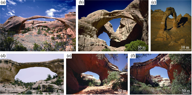
Figure 2 Typical natural arches and bridges on the Colorado Plateau, United States (a. Landscape Arch; b. Double Arch; c. Delicate Arch; d. Owachomo Bridge; e. Kachina Bridge; f. Sipapu Bridge; a-c are in Arches National Park, Utah; d-e are in Natural Bridges National Monument, Utah. The original pictures are taken by Jay Wilbur and downloaded from the Arches National Park Service, https://www.nps.gov/arch/index.htm.) |
Table 1 Geologic setting of red beds in Zhejiang province, China, and the Colorado Plateau, USA |
| Geological background | Red beds of Zhejiang province | Red beds of Colorado Plateau | |
|---|---|---|---|
| Tectonic activities | In red-bed formation | J3-K1, Yanshan Movement Act III; basin formation K1-K2, Yanshan Movement Act IV; fault and fold stratigraphic discordance K2-E, Yanshan Movement Act IV; differential vertical movement; magmatic intrusion | T3 Indosinian; plate subduction; continental deposit in Western Interior Basin J1-J2, Nevadan orogeny; continental aeolian sand deposit J2-K1, Seviler orogeny; Western Interior Seaway |
| In landscape formation | E-N, Himalayan movement crustal uplift | K2, Lamian orogeny; the Rocky Mountain uplifting, Colorado Plateau formation | |
| Basin types | Fault/down-warped basin | Back-arc basin | |
| Red-bed deposition time | K2, K1 | Mainly T3, J1, J2 | |
| Sedimentary facies | Continental (river-lake) facies, lack of marine facies | Mainly continental (aeolian)facies, consist of shore-neritic transitional facies | |
Table S1 Information of Danxia rock shelters in Zhejiang Province, China |
| Name | Latitude (°N) | Longitude (°E) | Mountain | Span | Width | Height | S/W | S/H | Strata | Source |
|---|---|---|---|---|---|---|---|---|---|---|
| Tianshengshiliang | 28.88 | 118.92 | Mt. Lanke | 28.97 | 30.66 | 7.06 | 0.94 | 4.10 | K1 Zhongdai Group | Field study |
| Meiyan shelter 1 | 28.87 | 118.92 | 16.11 | 20.70 | 4.15 | 0.78 | 3.88 | |||
| Meiyan shelter 2 | 28.87 | 118.92 | 9.18 | 22.71 | 4.18 | 0.40 | 2.20 | |||
| Meiyan shelter 3 | 28.87 | 118.92 | 4.43 | 14.62 | 2.08 | 0.30 | 2.13 | |||
| Dafo shelter | 28.76 | 120.46 | Mt. Longsheng | 128.13 | 41.54 | 9.69 | 3.08 | 13.22 | K1 Fangyan Group | |
| Canxia shelter | 29.17 | 121.02 | Mt. Chicheng | 8.00 | 9.60 | 3.80 | 0.83 | 2.11 | K2 Chicheng Group | |
| Ruixia shelter | 29.17 | 121.02 | 23.87 | 5.18 | 3.00 | 4.61 | 7.96 | |||
| Middle shelter | 29.17 | 121.02 | 12.46 | 8.72 | 4.63 | 1.43 | 2.69 | |||
| Yujing shelter 1 | 29.17 | 121.02 | 12.14 | 9.22 | 8.46 | 1.32 | 1.43 | |||
| Yujing shelter 2 | 29.17 | 121.02 | 7.39 | 7.81 | 6.56 | 0.95 | 1.13 | |||
| Ziyun shelter | 29.17 | 121.02 | 34.37 | 11.00 | 13.00 | 3.12 | 2.64 | |||
| Baiyun shelter | 29.17 | 121.02 | 27.00 | 10.00 | 8.50 | 2.70 | 3.18 | |||
| Lingxia shelter | 29.17 | 121.02 | 41.42 | 7.53 | 4.63 | 5.50 | 8.95 | |||
| Huixian shelter | 28.53 | 118.57 | Mt. Jianglang | 20.23 | 24.73 | 3.16 | 0.82 | 6.40 | K1 Fangyan Group | Peng et al., 2001 Zhu et al., 2009 Zhang et al., 2010 |
| Tiangong shelter | 28.53 | 118.57 | 15.73 | 8.67 | 4.60 | 1.81 | 3.42 | |||
| Jingxinshi shelter | 28.53 | 118.57 | 14.50 | 9.15 | 4.50 | 1.58 | 3.22 | |||
| Zhongguyan shelter | 28.54 | 118.57 | 20.50 | 4.35 | 3.77 | 4.71 | 5.44 | |||
| Xiaohuixian shelter | 28.54 | 118.57 | 30.40 | 6.70 | 9.80 | 4.54 | 3.10 | |||
| Xuankongsi shelter | 28.53 | 118.56 | 27.17 | 11.85 | 4.80 | 2.29 | 5.66 | |||
| Lingyansi shelter | 28.93 | 120.18 | Mt. Fangyan | 40.00 | 7.00 | 2.50 | 5.71 | 16.00 | Zhu et al., 2009 Ouyang et al., 2009 | |
| Hongfusi shelter | 28.93 | 120.18 | 100.00 | 21.00 | 15.00 | 4.76 | 6.67 | |||
| Wufeng canteen | 28.93 | 120.19 | 90.00 | 8.00 | 7.00 | 11.25 | 12.86 | |||
| Wufeng Yaodong | 28.93 | 120.19 | 56.00 | 36.00 | 30.00 | 1.56 | 1.87 | |||
| Wufeng academy | 28.87 | 120.13 | 21.12 | 51.29 | 4.30 | 0.41 | 4.91 | |||
| Gongpoyan shelter | 28.90 | 120.18 | 17.86 | 50.47 | 2.59 | 0.35 | 6.90 |
Table S2 Information of natural arches on the Colorado Plateau, USA |
| Name | Latitude (°N) | Longitude (°W) | Span | Width | Height | S/W | S/H | Strata | ||||||||||||||||||||||||||||||||
|---|---|---|---|---|---|---|---|---|---|---|---|---|---|---|---|---|---|---|---|---|---|---|---|---|---|---|---|---|---|---|---|---|---|---|---|---|---|---|---|---|
| Kolob Arch | 37.42 | 113.16 | 87.48 | 10.67 | 8.20 | Navajo | ||||||||||||||||||||||||||||||||||
| Jug Handle Arch | 37.20 | 112.99 | Navajo | |||||||||||||||||||||||||||||||||||||
| Square Arch | 37.64 | 112.85 | Abandoned | |||||||||||||||||||||||||||||||||||||
| Vermillion arch | 36.81 | 112.06 | 9.14 | Navajo | ||||||||||||||||||||||||||||||||||||
| Unnamed natural arch | 36.85 | 112.05 | 1.83 | Navajo | ||||||||||||||||||||||||||||||||||||
| Joannes arch | 36.99 | 112.01 | 3.05 | Navajo | ||||||||||||||||||||||||||||||||||||
| Dannys arch | 36.99 | 112.01 | 3.66 | Navajo | ||||||||||||||||||||||||||||||||||||
| Hole in the rock | 33.46 | 111.95 | 3.05 | Sandy | ||||||||||||||||||||||||||||||||||||
| Skylight Arch | 37.29 | 111.89 | Dalota entrada | |||||||||||||||||||||||||||||||||||||
| Fay canyon arch | 34.91 | 111.86 | 28.65 | Supai | ||||||||||||||||||||||||||||||||||||
| Hole in the rock | 36.94 | 111.85 | 9.14 | Navajo | ||||||||||||||||||||||||||||||||||||
| Wrather arch | 36.96 | 111.78 | 48.77 | Navajo | ||||||||||||||||||||||||||||||||||||
| Vultee arch | 34.94 | 111.77 | 12.19 | Supai | ||||||||||||||||||||||||||||||||||||
| Indian head arch | 34.94 | 111.75 | 14.63 | Navajo | ||||||||||||||||||||||||||||||||||||
| Metate Arch | 37.77 | 111.60 | Entrata | |||||||||||||||||||||||||||||||||||||
| Hole in rock | 36.57 | 111.41 | 1.07 | Navajo | ||||||||||||||||||||||||||||||||||||
| Navajo arch | 36.94 | 111.32 | 3.66 | Navajo | ||||||||||||||||||||||||||||||||||||
| Diagenetic arch | 36.97 | 111.21 | 7.62 | Navajo | ||||||||||||||||||||||||||||||||||||
| Sitting lizard arch | 36.63 | 111.18 | 9.14 | Navajo | ||||||||||||||||||||||||||||||||||||
| Tsai Skizzi | 36.81 | 111.09 | 12.19 | Navajo nation | ||||||||||||||||||||||||||||||||||||
| White craig arch | 36.55 | 111.02 | 9.14 | Navajo nation | ||||||||||||||||||||||||||||||||||||
| Arch in the sky | 36.90 | 110.99 | 22.86 | Navajo | ||||||||||||||||||||||||||||||||||||
| Buffalo rock | 36.75 | 110.98 | 1.52 | Navajo | ||||||||||||||||||||||||||||||||||||
| Stevens arch | 27.43 | 110.98 | 67.06 | |||||||||||||||||||||||||||||||||||||
| White Mesa arch | 36.47 | 110.98 | 16.15 | Dakota | ||||||||||||||||||||||||||||||||||||
| Mikes arch | 36.84 | 110.96 | 8.53 | Navajo | ||||||||||||||||||||||||||||||||||||
| Margaret arch | 36.55 | 110.96 | 12.19 | Dakota | ||||||||||||||||||||||||||||||||||||
| Quick arch | 36.98 | 110.94 | 10.36 | Navajo | ||||||||||||||||||||||||||||||||||||
| Egg shell arch | 36.68 | 110.79 | 33.22 | Navajo | ||||||||||||||||||||||||||||||||||||
| Flying Eagle Arch | 37.05 | 110.77 | Navajo | |||||||||||||||||||||||||||||||||||||
| Wild Horse Arch | 38.37 | 110.71 | 13.72 | |||||||||||||||||||||||||||||||||||||
| Eagle Canyon Arch | 38.99 | 110.69 | Wingate | |||||||||||||||||||||||||||||||||||||
| The Grotto | 37.81 | 110.43 | ||||||||||||||||||||||||||||||||||||||
| Honeymoon arch | 36.89 | 110.18 | 8.23 | Dechelly | ||||||||||||||||||||||||||||||||||||
| The spectacles | 36.92 | 110.14 | 12.19 | Dechelly | ||||||||||||||||||||||||||||||||||||
| Full moon arch | 36.91 | 110.14 | 8.23 | Dechelly | ||||||||||||||||||||||||||||||||||||
| Clara Bernheimer natural bridage | 36.88 | 110.03 | 8.23 | Dechelly | ||||||||||||||||||||||||||||||||||||
| Unnamed | 37.60 | 110.01 | 6.10 | 2.44 | 2.50 | Cedar mesa | ||||||||||||||||||||||||||||||||||
| Name | Latitude (°N) | Longitude (°W) | Span | Width | Height | S/W | S/H | Strata | ||||||||||||||||||||||||||||||||
| Unnamed | 37.60 | 110.01 | 4.57 | Cedar mesa | ||||||||||||||||||||||||||||||||||||
| Unnamed | 37.60 | 110.01 | 15.24 | Cedar mesa | ||||||||||||||||||||||||||||||||||||
| Skeleton arch | 36.89 | 109.97 | 12.19 | Dechelly | ||||||||||||||||||||||||||||||||||||
| Genevieves arch | 36.91 | 109.93 | 15.24 | Dechelly | ||||||||||||||||||||||||||||||||||||
| Sunrise arch | 36.91 | 109.93 | 10.67 | Dechelly | ||||||||||||||||||||||||||||||||||||
| Unnamed | 36.92 | 109.92 | 4.57 | Dechelly | ||||||||||||||||||||||||||||||||||||
| The Colonnade | 38.19 | 109.89 | 6.10 | 4.88 | 3.05 | 1.25 | 2.00 | |||||||||||||||||||||||||||||||||
| Forbidden arch | 36.96 | 109.88 | 7.62 | Dechelly | ||||||||||||||||||||||||||||||||||||
| Mesa Arch | 38.39 | 109.86 | 27.43 | Navajo | ||||||||||||||||||||||||||||||||||||
| Faraway Arch | 37.63 | 109.81 | 3.96 | Navajo | ||||||||||||||||||||||||||||||||||||
| Unnamed | 37.63 | 109.81 | 6.10 | Navajo | ||||||||||||||||||||||||||||||||||||
| Unnamed | 37.63 | 109.81 | 3.35 | 1.52 | 2.20 | Abandoned | ||||||||||||||||||||||||||||||||||
| Paul Bunyans Potty | 37.63 | 109.81 | 10.67 | Cedar mesa | ||||||||||||||||||||||||||||||||||||
| Musselman Arch | 38.17 | 109.76 | Organ rock | |||||||||||||||||||||||||||||||||||||
| Angel Arch | 38.17 | 109.76 | 36.58 | 41.15 | 0.89 | Cedar mesa | ||||||||||||||||||||||||||||||||||
| Castle Arch | 38.17 | 109.76 | 4.57 | 0.30 | 15.00 | Cedar mesa | ||||||||||||||||||||||||||||||||||
| Unnamed (Klingon Bird of Prey) | 38.17 | 109.76 | 13.72 | Cedar mesa | ||||||||||||||||||||||||||||||||||||
| Unnamed fin natural arch | 36.29 | 109.70 | 25.91 | Wingate | ||||||||||||||||||||||||||||||||||||
| Unnamed fin natural arch | 36.19 | 109.70 | 4.57 | Wingate | ||||||||||||||||||||||||||||||||||||
| Window rock | 36.28 | 109.69 | 10.67 | Wingate | ||||||||||||||||||||||||||||||||||||
| Hope arch | 36.20 | 109.69 | 19.81 | 1.83 | 21.34 | 10.83 | 0.93 | Wingate | ||||||||||||||||||||||||||||||||
| Window rock | 36.39 | 109.69 | 12.19 | Wingate | ||||||||||||||||||||||||||||||||||||
| Landscape Arch | 38.79 | 109.61 | 88.39 | Entrata | ||||||||||||||||||||||||||||||||||||
| Wall Arch (fallen) | 38.79 | 109.61 | 21.64 | 10.21 | 2.12 | Entrata | ||||||||||||||||||||||||||||||||||
| Window rock | 36.89 | 109.57 | 6.71 | Wingate | ||||||||||||||||||||||||||||||||||||
| Big Eye Arch | 38.68 | 109.57 | Entrata | |||||||||||||||||||||||||||||||||||||
| Double-O Arch | 38.68 | 109.57 | Entrata.double | |||||||||||||||||||||||||||||||||||||
| Top Story Window | 38.68 | 109.57 | Entrata | |||||||||||||||||||||||||||||||||||||
| Black Arch | 38.68 | 109.57 | 19.81 | 13.72 | 1.44 | Entrata | ||||||||||||||||||||||||||||||||||
| Surprise Arch | 38.68 | 109.57 | 18.29 | 15.24 | 1.20 | Entrata | ||||||||||||||||||||||||||||||||||
| Ribbon Arch | 38.68 | 109.57 | Entrata. abandoned | |||||||||||||||||||||||||||||||||||||
| Rock window | 36.62 | 109.56 | 21.34 | Wingate | ||||||||||||||||||||||||||||||||||||
| Hidden Canyon Rim Arch | 38.99 | 109.56 | 2.13 | 1.37 | 1.56 | Rim | ||||||||||||||||||||||||||||||||||
| Unnamed | 38.99 | 109.56 | Wingate | |||||||||||||||||||||||||||||||||||||
| Biscuit Arch | 38.99 | 109.56 | 2.44 | 1.37 | 1.78 | / | ||||||||||||||||||||||||||||||||||
| Window rock | 36.50 | 109.56 | 18.29 | 39.62 | 0.46 | Wingate | ||||||||||||||||||||||||||||||||||
| Unnamed | 38.57 | 109.55 | ||||||||||||||||||||||||||||||||||||||
| Gold Bar Arch | 38.57 | 109.55 | Navajo | |||||||||||||||||||||||||||||||||||||
| Corona Arch | 38.57 | 109.55 | Navajo | |||||||||||||||||||||||||||||||||||||
| Pritchett Arch | 38.57 | 109.55 | Navajo | |||||||||||||||||||||||||||||||||||||
| Double Arch | 38.69 | 109.54 | 45.11 | 31.70 | 1.42 | Entrata | ||||||||||||||||||||||||||||||||||
| Unnamed | 36.14 | 109.50 | 6.10 | Dechelly | ||||||||||||||||||||||||||||||||||||
| Name | Latitude (°N) | Longitude (°W) | Span | Width | Height | S/W | S/H | Strata | ||||||||||||||||||||||||||||||||
| Delicate Arch | 38.74 | 109.50 | 18.29 | Entrata | ||||||||||||||||||||||||||||||||||||
| Unnamed | 36.16 | 109.47 | 2.74 | Dechelly | ||||||||||||||||||||||||||||||||||||
| The window | 36.11 | 109.40 | 10.67 | Dechelly | ||||||||||||||||||||||||||||||||||||
| Arrowhead Arch (fallen) | 38.82 | 109.34 | 4.57 | Entrata | ||||||||||||||||||||||||||||||||||||
| unnamted butterss natural arch | 36.62 | 109.29 | 19.81 | 36.58 | Wingate | |||||||||||||||||||||||||||||||||||
| Royal arch | 36.61 | 109.24 | 23.16 | Wingate | ||||||||||||||||||||||||||||||||||||
| Unnamed fin natural arch | 36.61 | 109.23 | 1.22 | 3.66 | 0.33 | Wingate | ||||||||||||||||||||||||||||||||||
| Unnamed fin natural arch | 36.62 | 109.21 | 3.05 | Wingate | ||||||||||||||||||||||||||||||||||||
| Blackhorse arch | 36.70 | 109.18 | 9.14 | Wingate | ||||||||||||||||||||||||||||||||||||
| Unnamed | 37.21 | 109.16 | ||||||||||||||||||||||||||||||||||||||
| Elephant rock | 36.65 | 109.15 | 4.57 | Wingate | ||||||||||||||||||||||||||||||||||||
| Jonathan Jones Arch | 39.07 | 109.05 | 9.14 | Glen Group | ||||||||||||||||||||||||||||||||||||
| Window rock | 35.68 | 109.05 | 19.81 | Entrada | ||||||||||||||||||||||||||||||||||||
| Unnamed | 37.41 | 109.03 | 1.83 | Dakota | ||||||||||||||||||||||||||||||||||||
| Opinion Arch | 39.10 | 109.01 | 14.33 | 15.24 | 0.94 | Entrada | ||||||||||||||||||||||||||||||||||
| Unnamed | 35.92 | 109.00 | 4.57 | Entrada | ||||||||||||||||||||||||||||||||||||
| Sand Canyon Arch | 40.48 | 109.00 | 6.10 | Weber | ||||||||||||||||||||||||||||||||||||
| Unnamed | 40.50 | 108.98 | 2.44 | Park city | ||||||||||||||||||||||||||||||||||||
| Unnamed | 39.07 | 108.96 | 4.57 | Entrada | ||||||||||||||||||||||||||||||||||||
| Aperture Arch | 38.32 | 108.94 | ||||||||||||||||||||||||||||||||||||||
| The Great Eye | 35.93 | 108.94 | 4.57 | San Paphael group | ||||||||||||||||||||||||||||||||||||
| Unnamed | 38.97 | 108.93 | 2.44 | Kayenta | ||||||||||||||||||||||||||||||||||||
| Unnamed | 40.50 | 108.93 | 13.72 | Weber | ||||||||||||||||||||||||||||||||||||
| Unnamed | 38.97 | 108.92 | 9.14 | Wingate | ||||||||||||||||||||||||||||||||||||
| Outlaw Arch | 40.51 | 108.92 | 60.96 | Weber | ||||||||||||||||||||||||||||||||||||
| Dolores River Arch | 38.20 | 108.92 | ||||||||||||||||||||||||||||||||||||||
| Unnamed | 39.14 | 108.91 | 6.10 | 0.00 | Entrada | |||||||||||||||||||||||||||||||||||
| Will Minor Arch | 39.13 | 108.91 | 9.14 | 10.67 | 0.86 | Entrada | ||||||||||||||||||||||||||||||||||
| Bulwark Arch | 39.12 | 108.91 | 6.10 | Entrada | ||||||||||||||||||||||||||||||||||||
| Arete Arch | 39.12 | 108.91 | 6.10 | Entrada | ||||||||||||||||||||||||||||||||||||
| Unnamed | 38.98 | 108.90 | 9.14 | Wingate | ||||||||||||||||||||||||||||||||||||
| Crown Arch | 39.13 | 108.90 | 3.66 | Entrada double | ||||||||||||||||||||||||||||||||||||
| Tubloc Arch | 39.13 | 108.90 | 3.05 | Entrada | ||||||||||||||||||||||||||||||||||||
| Juanita Arch | 38.57 | 108.89 | 30.48 | Wingate meander | ||||||||||||||||||||||||||||||||||||
| Bent Pine Tree Arch | 38.98 | 108.89 | 14.94 | Chinle | ||||||||||||||||||||||||||||||||||||
| Two Feathers Arch | 39.14 | 108.89 | 3.05 | Entrada | ||||||||||||||||||||||||||||||||||||
| Unnamed | 39.05 | 108.89 | 6.71 | 3.96 | 1.69 | Entrada | ||||||||||||||||||||||||||||||||||
| Protractor Arch | 39.12 | 108.89 | 9.14 | Entrada double | ||||||||||||||||||||||||||||||||||||
| Unnamed (fallen) | 38.99 | 108.88 | 1.83 | Kayenta | ||||||||||||||||||||||||||||||||||||
| Unnamed | 39.15 | 108.86 | 2.44 | Entrada | ||||||||||||||||||||||||||||||||||||
| Trail Arch | 39.16 | 108.86 | Entrada | |||||||||||||||||||||||||||||||||||||
| Unnamed | 39.04 | 108.85 | 9.14 | Entrada | ||||||||||||||||||||||||||||||||||||
| Name | Latitude (°N) | Longitude (°W) | Span | Width | Height | S/W | S/H | Strata | ||||||||||||||||||||||||||||||||
| Unnamed | 39.15 | 108.85 | 3.05 | Entrada | ||||||||||||||||||||||||||||||||||||
| Unnamed | 39.15 | 108.85 | 2.13 | Entrada | ||||||||||||||||||||||||||||||||||||
| Centennial Arch | 39.14 | 108.85 | 19.81 | Entrada | ||||||||||||||||||||||||||||||||||||
| Unnamed | 39.14 | 108.85 | 4.57 | Entrada | ||||||||||||||||||||||||||||||||||||
| Unnamed | 39.03 | 108.85 | 13.72 | Entrada | ||||||||||||||||||||||||||||||||||||
| Finger Arch | 39.13 | 108.85 | 21.34 | Entrada | ||||||||||||||||||||||||||||||||||||
| Unnamed | 39.14 | 108.85 | Entrada | |||||||||||||||||||||||||||||||||||||
| Trap Arch | 39.14 | 108.84 | 9.14 | Entrada | ||||||||||||||||||||||||||||||||||||
| Cedar Tree Arch | 39.14 | 108.84 | 15.24 | Entrada | ||||||||||||||||||||||||||||||||||||
| Unnamed | 39.15 | 108.83 | 7.62 | Entrada | ||||||||||||||||||||||||||||||||||||
| Window Rock Tower | 39.14 | 108.83 | 1.83 | Entrada | ||||||||||||||||||||||||||||||||||||
| West Pollock Arch | 39.14 | 108.82 | 10.67 | Entrada | ||||||||||||||||||||||||||||||||||||
| Unnamed | 38.40 | 108.82 | 3.66 | Wingate | ||||||||||||||||||||||||||||||||||||
| Unnamed | 39.15 | 108.82 | ||||||||||||||||||||||||||||||||||||||
| Windows of Pollock Cyn | 39.12 | 108.82 | 15.24 | Entrada double | ||||||||||||||||||||||||||||||||||||
| E Rock Creek Cyn Arch | 37.37 | 108.81 | 10.67 | Entrada | ||||||||||||||||||||||||||||||||||||
| Unnamed | 39.45 | 108.78 | 3.35 | Mount garfield | ||||||||||||||||||||||||||||||||||||
| Unnamed | 39.84 | 108.74 | 3.05 | Mesa verde | ||||||||||||||||||||||||||||||||||||
| Unnamed | 39.08 | 108.73 | 1.22 | Wingate | ||||||||||||||||||||||||||||||||||||
| Window Rock | 39.11 | 108.73 | 4.57 | Kayenta | ||||||||||||||||||||||||||||||||||||
| Unnamed | 39.05 | 108.72 | 1.68 | Entrada | ||||||||||||||||||||||||||||||||||||
| Squaw Finger Arch | 39.07 | 108.72 | ||||||||||||||||||||||||||||||||||||||
| Kissing Couple | 39.09 | 108.71 | Wingate | |||||||||||||||||||||||||||||||||||||
| Culvert Arch | 39.03 | 108.65 | 0.91 | Wingate | ||||||||||||||||||||||||||||||||||||
| Unnamed | 37.57 | 108.26 | 3.66 | |||||||||||||||||||||||||||||||||||||
| Escarpment Arch | 40.30 | 108.12 | 2.44 | Fort union | ||||||||||||||||||||||||||||||||||||
| Unnamed | 35.62 | 108.11 | Point lookout | |||||||||||||||||||||||||||||||||||||
| Unnamed | 39.90 | 107.96 | 2.44 | 4.88 | 0.50 | Williams fork | ||||||||||||||||||||||||||||||||||
| La Ventana | 34.87 | 107.89 | 41.15 | 24.38 | 1.69 | Dakota | ||||||||||||||||||||||||||||||||||
| Rhoda's Arch | 37.66 | 107.00 | 15.24 | / | ||||||||||||||||||||||||||||||||||||
| Unnamed | 38.59 | 105.25 | 3.05 | |||||||||||||||||||||||||||||||||||||
| Seventeenth Hole Arch | 39.61 | 105.18 | 5.49 | Fountain formation | ||||||||||||||||||||||||||||||||||||
| Eighteenth Hole Arch | 39.61 | 105.18 | 3.66 | Fountain formation | ||||||||||||||||||||||||||||||||||||
| La Veta Arches | 37.45 | 105.03 | ||||||||||||||||||||||||||||||||||||||
| Elephant Rock | 39.12 | 104.89 | 5.49 | 10.67 | 0.51 | Dawson formation | ||||||||||||||||||||||||||||||||||
| Siamese Twins | 38.87 | 104.89 | 1.83 | Fountain formation | ||||||||||||||||||||||||||||||||||||
| Pigs Eye | 38.87 | 104.88 | 4.57 | Lyons formation | ||||||||||||||||||||||||||||||||||||
| Kissing Camels | 38.88 | 104.88 | 2.44 | Lyons formaiton | ||||||||||||||||||||||||||||||||||||
| Name | Latitude (°N) | Longitude (°W) | Span | Width | Height | S/W | S/H | Strata | ||||||||||||||||||||||||||||||||
| Picture Window | 37.62 | 103.61 | 1.83 | Dakolta | ||||||||||||||||||||||||||||||||||||
| Window Rock | 37.62 | 103.61 | 3.66 | 1.22 | 3.00 | Dakota abandoned | ||||||||||||||||||||||||||||||||||
| Wisdom Tooth | 37.02 | 102.77 | 7.62 | 4.57 | 1.67 | Dakota | ||||||||||||||||||||||||||||||||||
| Unnamed | 35.04 | 101.76 | 3.05 | |||||||||||||||||||||||||||||||||||||
| Judys Arch | 34.93 | 101.65 | 3.66 | 9.45 | 0.39 | Quartermaster formation | ||||||||||||||||||||||||||||||||||
| Unnamed | 34.39 | 87.63 | 37.19 | 8.23 | 4.11 | 4.52 | 9.04 | |||||||||||||||||||||||||||||||||
| Unnamed | 34.18 | 87.28 | 15.24 | 6.10 | 2.50 | |||||||||||||||||||||||||||||||||||
Table S3 Information of natural bridges on the Colorado Plateau, USA |
| Name | Latitude (°N) | Longitude (°W) | Span | Width | Height | S/W | S/H | Strata |
|---|---|---|---|---|---|---|---|---|
| NB Mountain Arch | 37.21 | 112.97 | 12.19 | Navajo sandstone, propped | ||||
| Devils NB | 34.90 | 111.81 | 13.72 | Supai sandstone | ||||
| Escalante,Utah | 37.77 | 111.60 | 39.62 | 3.66 | 21.34 | 10.83 | 1.86 | |
| Hickman Natural NB | 38.20 | 111.17 | 40.54 | Kayenta sandstone, shelter | ||||
| Rainbow NB | 37.08 | 110.96 | 71.32 | 74.68 | 0.96 | Navajo sandstone, menader | ||
| Kachina Natural NB | 37.60 | 110.01 | 58.52 | Cedar mesa sandstone, meander | ||||
| Owachomo Natural NB | 37.60 | 110.01 | 54.86 | 8.23 | 26.21 | 6.67 | 2.09 | Cedar mesa sandstone, meander |
| Sipapu Natural NB | 37.60 | 110.01 | 68.58 | 12.50 | 43.89 | 5.49 | 1.56 | Cedar mesa sandstone, meander |
| Hawkeye Natural NB | 37.63 | 109.81 | 45.42 | Navajo sandstone, alcove | ||||
| Moring glory NB | 38.61 | 109.53 | 74.07 | 22.86 | 3.24 | Sandstone, alcove | ||
| Three turkey natural NB | 36.02 | 109.40 | 15.24 | 5.49 | 6.71 | 2.78 | 2.27 | Sandtone, waterfall, wash |
| Black rock natural NB | 35.71 | 109.10 | 14.94 | Shinarump conglomerate, waterfall, creek | ||||
| Red Lake Natural NB | 35.93 | 109.02 | 30.48 | Entrada sandstone, shelter | ||||
| Snake NB | 36.42 | 109.02 | 62.18 | 6.10 | 18.59 | 10.20 | 3.34 | Entrada sandstone, meander |
| Hole in the NB Arch | 39.15 | 108.85 | 12.19 | Entrada sandstone, cave | ||||
| Ela Natural NB | 39.00 | 108.83 | 13.72 | Entrada sandstone, alcove | ||||
| Eagles Point Natural NB | 34.44 | 101.07 | 4.27 | 15.85 | 2.44 | 0.27 | 1.75 | Quartermaster formation, sandstone, gypsum, waterfall |
| Rock NB | 34.36 | 87.93 | 18.29 | 15.24 | 1.20 | |||
| Natural NB | 34.09 | 87.61 | 30.48 | |||||
| Hartselle natural NB | 34.48 | 86.89 | 6.10 | 0.91 | 6.67 |
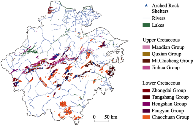
Figure 3 Map showing the distribution of Upper and Lower Cretaceous strata in Zhejiang province (Blue stars indicate arched rock shelters in red beds.) |
Table 2 The studied number of arches (shelters, arches and bridges) in the red-bed formations in Zhejiang province, China, and the Colorado Plateau, USA |
| Strata | Formation | I* | Strata | Formation | II* |
|---|---|---|---|---|---|
| K2 | Quxian Group | 1 | E | Fort Union Formation | 1 |
| Mt. Chicheng Group | 8 | Dawson Formation | 1 | ||
| K1 | Fangyan Group | 16 | K2 | Mesa verde sandstone | 1 |
| Zhongdai Group | 8 | Williams fork sandstone | 1 | ||
| Tangshang Group | 2 | Dakota sandstone | 8 | ||
| Hengshan Group | 2 | K1 | De Chelly sandstone | 12 | |
| Chaochuan Group | 2 | J2 | Mount Garfield, Escalante Member | 1 | |
| Entrada sandstone | 32 | ||||
| J1 | Navajo sandstone | 27 | |||
| T3 | Kayenta sandstone | 3 | |||
| Wingate sandstone | 23 | ||||
| Chinle sandstone | 1 | ||||
| Glen Canyon Group | 1 | ||||
| P2 | Lyons Formation | 2 | |||
| Strata | Formation | III* | P1 | Quartermaster Formation | 1 |
| J2 | Entrada sandstone | 4 | Cedar mesa sandstone | 7 | |
| J1 | Navajo sandstone | 3 | Organ Rock Formation | 1 | |
| P1 | Quartermaster | 1 | Supai sandstone | 2 | |
| Cedar mesa sandstone | 3 | C2 | Fountain Formation, Late Pennsylvanian | 3 | |
| Supai sandstone | 1 | Weber sandstone, Early Pennsylvanian | 3 |
* I-Numbers of Danxia arched rock shelters; II-Numbers of natural arches; III-Numbers of natural bridges |
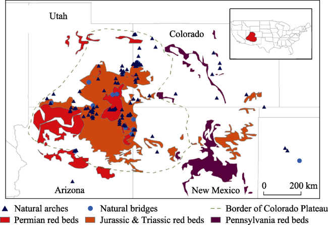
Figure 4 Map showing the distribution of Pennsylvanian, Permian, Triassic, and Jurassic red beds on the Colorado Plateau (updated from Pan et al. 2018; Blue symbols indicate natural arches and bridges in red beds.) |
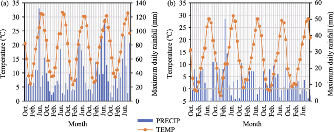
Figure 5 Temperature and precipitation features of two study areas (a. Zhejiang province; b. Colorado Plateau) |
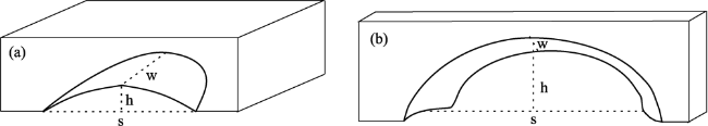
Figure 6 Schematic sketches showing measurement of (a) rock shelters and (b) natural arches and bridges (s - span; w - width; h - height) |
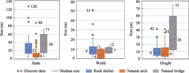
Figure 7 Box-whisker plot of the dimension of the arched rock shelter, natural arches and bridges. The box indicates the interquartile range (25%-75%) of all data. The whisker upper/lower limit is the maximum/minimum data point that extends to 1.5 times the height of the box at the top/bottom of the box. The discrete points are the data beyond the whisker upper and lower limits. Data 25, 167, and 20 are included in the statistic diagram of the rock shelter, the natural arch, and the natural bridge, respectively. |
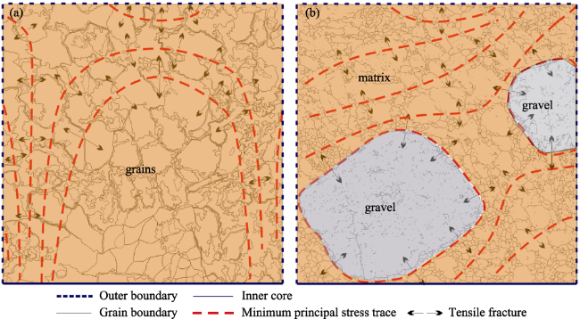
Figure 8 Schematic sketches showing the difference between moisture stresses in (a) sandstone and (b) conglomerate (Tan et al. 2019) |
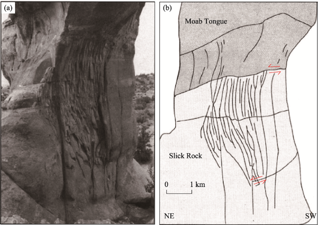
Figure 9 Photograph (a) and illustrative sketch (b) showing intense fractures and shear displacement on the southeast leg of Broken Arch, Arches National Park, Utah, USA. The fractures end close to the bedding plane between the Slick Rock and Moab Tongue Members of the Entrada Sandstone. The Moab Tongue Member is hard enough to stop the fractures and keep an intact roof on the natural arch (Cruikshank and Aydin, 1994). |
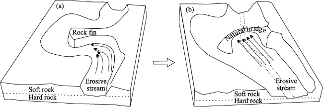
Figure 10 Formation of the natural bridge (a. Initial stage; b. Mature stage) |
The authors thank the photographer, Jay Wilbur, for providing the photos of natural arches and bridges, and David Brandt-Erichsen, the webmaster of Natural Arch and Bridge Society, for his assistance in obtaining the photographer’s permission to use the photos in this paper.
| [1] |
|
| [2] |
|
| [3] |
|
| [4] |
|
| [5] |
|
| [6] |
|
| [7] |
|
| [8] |
|
| [9] |
|
| [10] |
|
| [11] |
|
| [12] |
|
| [13] |
|
| [14] |
|
| [15] |
|
| [16] |
|
| [17] |
|
| [18] |
|
| [19] |
|
| [20] |
|
| [21] |
|
| [22] |
|
| [23] |
|
| [24] |
|
| [25] |
|
| [26] |
|
| [27] |
|
| [28] |
|
| [29] |
|
| [30] |
|
| [31] |
|
| [32] |
|
| [33] |
|
| [34] |
|
| [35] |
|
| [36] |
|
| [37] |
|
| [38] |
|
| [39] |
|
| [40] |
|
| [41] |
|
| [42] |
|
| [43] |
|
| [44] |
|
| [45] |
|
| [46] |
|
| [47] |
|
| [48] |
|
| [49] |
|
| [50] |
|
| [51] |
|
| [52] |
|
| [53] |
|
| [54] |
Zhejiang Bureau of Geology and Mineral Resources, 1989. Regional Geology of Zhejiang Province. Beijing: Geological Publishing House. (in Chinese)
|
| [55] |
|
| [56] |
|
| [57] |
|
/
| 〈 |
|
〉 |