Research Articles

Paleoclimatic proxies from global closed basins and the possible beginning of Anthropocene

  • LI Yu ,
  • HAN Qin ,
  • HAO Lu ,
  • ZHANG Xinzhong ,
  • CHEN Dawei ,
  • ZHANG Yuxin ,
  • XU Lingmei ,
  • YE Wangting ,
  • PENG Simin ,
  • LI Yichan ,
  • FENG Zhuowen ,
  • LIU Hebin
Expand
  • Key Laboratory of Western China’s Environmental Systems (Ministry of Education), College of Earth and Environmental Sciences, Center for Hydrologic Cycle and Water Resources in Arid Region, Lanzhou University, Lanzhou 730000, China

Li Yu (1981-), Professor, specialized in paleoclimatic change. E-mail:

Received date: 2020-06-17

  Accepted date: 2020-09-08

  Online published: 2021-08-25

Supported by

The National Key Research and Development Program of China(2019YFC0507401)

National Natural Science Foundation of China(42077415)

National Natural Science Foundation of China(41822708)

The Second Tibetan Plateau Scientific Expedition and Research Program(STEP)(2019QZKK0202)

The Strategic Priority Research Program of Chinese Academy of Sciences(XDA20100102)

Abstract

Global closed basins, occupying almost one fifth of the world’s land area, spatially coincide with arid and semiarid areas. Paleoclimatic proxies can indicate basin-wide environmental change and human activity. However, previous studies have not approached the use of proxies in the same way to reconstruct natural and anthropogenic processes at regional and global scales. Here we present a regional study to investigate the basic processes of paleoclimatic proxies, from a typical closed-basin system in arid China. We use multiple paleoclimatic proxies of surface samples and sediments, as well as groundwater and sediment ages to study environmental change and human activity. We then establish a dataset for paleoclimatic proxies from global closed basins and do a numerical analysis on it. Regional studies verify that human activity greatly impacts paleoclimatic proxies, especially with regard to surface samples, as well as groundwater age, but Holocene sediments are less affected. Results from global studies indicate that the major changing trend of the wet/dry status of closed basins is associated with the movement of the westerly jet streams controlled by long-term changes in winter insolation. There is an abrupt change between 1800 AD and 1900 AD, according to a numerical synthesis of paleoclimatic proxies from global closed basins, which can be linked to human impact. We suggest this time period can be considered as a start point for the Anthropocene based on the sedimentary evidence of closed basins, globally.

Cite this article

LI Yu , HAN Qin , HAO Lu , ZHANG Xinzhong , CHEN Dawei , ZHANG Yuxin , XU Lingmei , YE Wangting , PENG Simin , LI Yichan , FENG Zhuowen , LIU Hebin . Paleoclimatic proxies from global closed basins and the possible beginning of Anthropocene[J]. Journal of Geographical Sciences, 2021 , 31(6) : 765 -784 . DOI: 10.1007/s11442-021-1870-8

1 Introduction

Environmental change at different timescales varies and is stored in different carriers. Modern detection technology has been able to better extract information on environmental change from these carriers. Over the past few decades, published multi-proxy paleoclimatic data have been focused on climatic and environmental reconstruction, such as variation in precipitation, temperature, and vegetation (Xiao et al., 2014; Chen et al., 2015; Liu et al., 2015). It is generally believed that environmental change during the Holocene is strongly influenced by natural climatic forcing. However, paleoclimatic proxies, such as pollen, magnetic susceptibility, isotopes, and n-Alkanes, indicate that human activity has also contributed to environmental change (Park et al., 2010; Huang et al., 2017; Zhang et al., 2019). Scientists, however, do not use proxies in the same way to reconstruct natural and anthropogenic processes at regional and global scales. Moreover, modern processes involving paleoenvironmental proxies are currently poorly understood.
During the Holocene, the environment was affected by climate change and human activity (Park et al., 2010; Huang et al., 2017; Zhang et al., 2019). The intensity and scope of human activity have gradually increased since the late Holocene (Huang et al., 2017; Zhang et al., 2019), and exploring its impact on environmental evolution and the identification of proxies related to human activity has been the research focus of Holocene environmental change. Global closed basins, occupying almost one fifth of the world’s land area, spatially coincide with arid and semiarid zones (Liet al., 2017c; Wang et al., 2018). Given their low precipitation but high evaporation, the hydrological cycle of closed basins is aggravated by environmental change and human impact (Wang et al., 2018). Increasing evidence suggests a sharp decline in the water storage of closed basins, leading to a series of social and environmental challenges (Rodell et al., 2018; Wang et al., 2018). As there is no outlet or hydrological connection to the oceans in closed basins, terminal lakes function as oceans and concentrate the sedimentary information of the whole basin (Li et al., 2017c). Therefore, climate change and human activity in closed basins are reflected by terminal lake sediments. The term “Anthropocene” was coined by Crutzen and Stoermer in 2000 to describe an unprecedented epoch in which collective human activity is impacting earth’s surface (Crutzen and Stoermer, 2000; Zalasiewicz et al., 2011). Numerous studies have focused on the Anthropocene (Lewis et al., 2011), but the beginning of the Anthropocene is multiple and uncertain. Compared with open basins, paleoclimatic proxies in closed basins contain more information (Li et al., 2017c). Since the Anthropocene is a period of geological history, stratigraphic evidence is the most direct evidence, and the history of human activity, therefore, is studied using lake sediments in global closed basins.
The closed basins of the Qilian Mountains, which are located in the arid region of northwestern China, are considered an appropriate area in which to explore the process of climate change and the effects of anthropogenic activity (Huang et al., 2017; Li et al., 2017c). Here we investigate the basic processes involving paleoclimatic proxies in the closed basins of the Qilian Mountains as a case study. This facilitates the general exploration of the impact of human activity and climate change on the paleoclimatic proxies of closed basins. Multiple paleoclimatic proxies of surface and lake sediments, as well as groundwater ages, were used to estimate environmental change and human activity (Supplementary Figure 1). Using paleoclimatic proxies in the closed basins of the Qilian Mountains, we evaluated the impact of human activity and climate change on the paleoclimatic proxies of the closed basins. Data concerning paleoclimatic proxies from terminal lakes in 34 closed basins were gathered to study environmental change and human impact on a global scale. Finally, we identified the main factors affecting change in global paleoclimatic proxies and recommended the beginning of the Anthropocene.
Supplementary Figure 1 Lithostratigraphic units and ages from the closed basins of the Qilian Mountains (14C ages are shown on the right side of the profile, unit: cal yr BP)

2 Materials, data and methods

2.1 Regional setting

Closed basins are regions in which surface runoff cannot flow into an ocean, but only into inland lakes, swamps, or disappear in the interior. Global closed basins, occupying almost one fifth of the world’s land area, spatially coincide with arid and semiarid areas (Liet al., 2017c; Wang et al., 2018). Given their low precipitation but high evaporation, the hydrological cycle of closed basins is sensitive to environmental change and human activity (Wang et al., 2018); and terminal lakes function as an ocean for closed basins and concentrate on the sedimentary information of a whole basin (Li et al., 2017c). Therefore, closed basins are recognized as sentinel ecosystems regarding environmental change and human impact.
The closed basins of the Qilian Mountains are located at the intersection of the eastern monsoonal domain, northwestern arid area, and the Qinghai-Tibet Plateau region, with the geographical coordinates of 34°41'‒42°48'N, 87°49'‒104°12'E (Figure 1). The basins consist of the drainage basins of the Shiyang River, the Heihe River, the Shule River, the Qaidam Basin, and Qinghai Lake. Today’s climate is mainly controlled by the mid-latitude westerly circulation and the Asian monsoon. With changing elevation in the closed basins of the Qilian Mountains, the vegetation distribution presents obvious vertical zonality. The closed basins of the Qilian Mountains were an important part of the Silk Road, facilitating cultural exchanges between eastern and western Eurasia in prehistoric and historical times (Yanget al., 2016).
Figure 1 Elevation map of the closed basins in the Qilian Mountains (upper map), and maps showing sampling points in the river basins of Shiyang (a), Fengle (b), Shiyou (c), and Buha (d) (lower maps)

2.2 Surface soil paleoclimatic proxies and groundwater age in the closed basins of the Qilian Mountains

To obtain sufficient data covering the study area, field work was carried out during April 2017 in four drainage basins, namely, the Shiyang River basin, the Fengle River basin, the Shiyou River basin, and the Buha River basin (Figure 1). The Fengle and Shiyou rivers are the tributaries of the Heihe and Shule rivers, respectively. A total of 172 representative samples were obtained, including 43 groundwater samples and 129 surface soil samples.

2.2.1 14C dating and isotopic analysis of groundwater dissolved inorganic carbon

From the upstreams to the downstreams of the Shiyang River basin, Shiyou River basin, Fengle River basin, and the Buha River basin, samples were taken from mountain springs, water supply wells for urban residents, and irrigation wells. Before sampling, the wells were pumped for more than one hour. Sample bottles were washed three to five times with the collected water, sampling double for each sample site. pH and total dissolved solids (TDS) were measured onsite using a SevenGo DuoTM multi-parameter tester SG230. Basic information, such as latitude, longitude, altitude, and well depth of the sampling points, were recorded.
Using the method of Kusakabe (2001), dissolved inorganic carbon (DIC) was precipitated on site as BaCO3 by adding 90 ml of saturated Ba(OH)2 solution to 550 ml of a groundwater sample. The precipitated BaCO3 in the groundwater samples was filtered with quantitative filter paper, rinsed several times with deionized water, then sealed in a glass vial and dried in the laboratory. The δ 13C and δ 18O of the DIC samples were detected using a Finnigan Mat 253 Plus isotope mass spectrometer at the Beijing Createch Testing Technology Co., Ltd. 14C dating of the DIC in the groundwater (Figure 1) was carried out in the Radiocarbon Dating Laboratory of Beijing University, where the samples were treated and dated using accelerator mass spectrometry (AMS). The 14C concentration is given as “percent modern carbon” (PMC) and converted to a conventional radiocarbon age (AMS 14C). It is generally believed that after the inorganic carbon of groundwater is isolated from the 14C of soil, the exchange of 14C with the outside world is stopped, and in a closed system begins to decay, according to the law of radioactive decay. The decay equation is:
${{A}_{nd}}={{A}_{0}}\cdot {{e}^{-\lambda t}}$
Obtained by logarithmic transformation:
$t=\frac{1}{\lambda }\ln \frac{{{A}_{0}}}{{{A}_{nd}}}=-8267\ln \frac{{{A}_{0}}}{{{A}_{nd}}}$
where t is the 14C age (yr BP) of groundwater; And is the 14C concentration measured in the sample; A0 is the “initial”, corrected for changes due to the interaction with the aquifer matrix; and λis the 14C decay constant, generally taken to be 5730 (Clark et al., 1997). Since groundwater is affected by geochemical reactions during recharge and flow processes, A0 is usually less than 100 PMC. Therefore, the initial input value A0 is corrected during groundwater 14C dating. All 14C dates in this study were corrected based on the following models:
(1) Vogel model
The radiocarbon data were used semi-quantitatively here. In northwestern China, an upper limit of about 80 PMC for initial 14C activity has been broadly used (Zhu et al., 2008). This is similar to the value used in the study on Western Europe and South Africa (Vogel et al., 1970).
(2) Pearson model (Pearson et al., 1967)
${{A}_{0}}=\frac{[{{\delta }^{13}}{{C}_{DIC}}]-[{{\delta }^{13}}{{C}_{carb}}]}{[{{\delta }^{13}}{{C}_{soil}}]-[{{\delta }^{13}}{{C}_{carb}}]}({{A}_{soil}}-{{A}_{carb}})+{{A}_{carb}}(\% mod )$
where δ13CDIC and δ13Csoil are measured in the sample;δ13Ccarb is the value of dissolved calcite. Acarb = 0%, Asoil = 100%, δ13Ccarb = 0‰.δ13Csoil = ‒23‰/‒25‰/‒9‰ (The study area comprised mainly C3 vegetation, with a value of ‒23‰).
(3) Improved isotope correction model (Gates et al., 2008)
$q=\frac{{{\delta }^{13}}{{C}_{DIC}}-{{\delta }^{13}}{{C}_{carb}}}{{{\delta }^{13}}{{C}_{rech}}-{{\delta }^{13}}{{C}_{carb}}}$
where carb and rech represent solid phase carbonate and make-up water. Assuming δ13Ccarb = 0‰, the content of14C = 0 PMC; the content of soil gas phase 14C=100 PMC, δ13Csoil = ‒23‰.δ13Crech is calculated using the following equation:
${{\delta }^{13}}{{C}_{rech}}={{\delta }^{13}}{{C}_{soil}}+{{\varepsilon }^{13}}{{C}_{DIC-C{{O}_{2}}\left( soil \right)}}$
where ε13Cis the fractionation coefficient between DIC and soil CO2. δ13Crechis the pre-mountain recharge area, identified as modern water, such as the Badain Jaran Desert W34 sample by Gates et al. (2008) (δ13Crech= ‒9.8). So, δ13Crech= ‒9.8 for calculation here.
${{A}_{0}}=q\left( {{A}_{soil}}-{{A}_{carb}} \right)+{{A}_{carb}}\left( \% mod \right)$
(4) Fontes and Garnier model (Fontes and Garnier, 1979)
${{A}_{0}}=\frac{mDI{{C}_{meas}}-mDI{{C}_{carb}}_{{}}+mDI{{C}_{C{{O}_{2}}-exch}}_{{}}}{mDI{{C}_{meas}}_{{}}}\cdot {{A}_{soil}}$
where mDICcarb is the concentration of inorganic carbon from carbonate minerals (mDICcarb= 0 PMC. Considering that the exchange amount of matrix DIC and soil CO2is small, mDICCO2-carb can be neglected (Fontes and Garnier, 1979); that is, the isotope exchange between DIC and matrix DIC in groundwater is the main exchange process); mDICmeas is the dissolved inorganic carbon concentration in groundwater; mDICCO2-exch is the exchange amount of aquifer matrix and soil CO2.

2.2.2 Paleoclimatic proxy data analysis on surface soil

Adjacent surface sediments were taken in the Shiyang river basin, the Shiyou river basin, the Fengle river basin, and the Buha river basin at an interval of 2-5 km. Total organic carbon (TOC) and the carbon isotopic composition of organic matter (δ13Corg) are commonly used as organic matter proxies in paleoclimatic and paleoenvironmental studies (Meyers, 1994). TOC can directly indicate organic matter input, and then indicate regional primary productivity (Balascio et al., 2013). δ 13Corg is often used to support interpretations for the results of C/N ratios. Based on the principle that different photosynthetic pathways lead to different ranges of δ 13Corg distribution values between C3 and C4 plants (Meyers, 1994), δ 13Corg values are useful in identifying organic matter from different types of land plants (Meyers, 1994). C3 and C4 plants have different and non-overlapping carbon isotope distribution ranges, ranging from ‒34‰ to ‒23‰ and ‒22‰ to ‒6‰, respectively (O'Leary, 1988). Organic matter has little or almost no carbon isotope fractionation during plant death and burial. The δ 13Corg values of sedimentary organic matter originating from terrestrial plants can, consequently, be determined. The δ 13Corg composition of aquatic macrophytes is complex and has a broad range (Allen and Spence, 1981). TOC was measured by a Vario-type Ⅲ element analyzer at labs of Lanzhou University, and δ 13Corg was measured using a Thermo Electron Corporation Company Finnigan MAT 252 isotope mass spectrometer at the Lanzhou Institute of Geochemistry, Chinese Academy of Sciences.
The formation and positioning of soil pedogenic carbonate are mainly affected by climate (Li et al., 2020). δ 13Cinorg and δ 18Oinorg were detected by a Finnigan Mat 253 Plus isotope mass spectrometer at the Beijing Createch Testing Technology Co., Ltd.
Grain size is one of the important proxies in sedimentology, capable of reflecting the material source, transport mechanism, and environment of the sediments. All grain-size analysis in this paper was completed at the Key Laboratory of Western China’s Environmental Systems (Ministry of Education) of Lanzhou University. The test instrument was the Mastersizer 2000 particle analyzer (MALVERN), with a measuring range of 0.02-2000 μm and a repeat error of less than 2%.
Discriminant analysis was used to classify the environmental indicators of surface sediments into three categories, according to the different elevations of the watershed (Qi and Luo, 2005; Li et al., 2017b). The discriminant prior group was determined through an analysis of surface sediment samples. On this basis, a discriminant analysis method was used to determine the representativeness of paleoenvironmental proxies of surface sediment for a given watershed elevation; the discriminant function was then established. The distance between various points and the centroid of the prior group can be used to judge the representative strength of a sample from a given elevation; therefore, the characteristics of different samples were analyzed.

2.3 Paleoclimatic proxy data analysis of sediments in regional and global closed basins

This paper selected sedimentary cores based on literature searches aided with the ISI Web of Science platform using the terms “closed basins,” “lake records,” “lake sediments,” “endorheic basins,” “arid regions,” “Holocene,” “climate change,” “paleoclimatic proxies,” “human activity,” and “Anthropocene.” The location information of sediment cores, paleoclimatic proxy data, and sediment ages were extracted to analyze paleoclimatic change and human activity in global closed basins (Supplementary Table 2).
We compiled lake records of 34 sites in global closed basins from recently published literature. Wet/dry change is the primary controlling factor of lake evolution in closed basins in arid regions, so we mainly collected data reflecting wet/dry change. The terminal lake records in this region were selected from available published sources based on three criteria: (1) The record should have reliable chronologies and successive sedimentary sequences; (2) the proxies should be indicative of moisture changes in this study; (3) 14C ages were calibrated to calendar years (cal yr BP).
The key concept of principal component analysis (PCA) is to convert multiple factors into a few representative comprehensive factors by means of dimensionality reduction. These factors are sufficient to represent most of the original information, achieving the purpose of limiting the number of variables. Closed basins were relatively dispersed in a vast geographical range. To simplify the underlying mechanisms of paleoclimatic proxies, the PCA approach was used, which converts paleoenvironmental indicators of multiple lakes into a few comprehensive unrelated variables. By reducing composite indicators to a few principal components, the results will scientifically and effectively reflect the mechanism behind the indicators.
We unified the significance of different indicators. That is, if the indicators were more positive, it meant that the climate was more humid, otherwise it meant that the climate was drier. We interpolated each record at 30-year intervals and unified the time scale according to the chronology accuracy of the extracted data.
All selected paleoclimatic proxies of individual lakes were first analyzed using PCA to extract the first principal component (PCA1); then the PCA1 results of 34 lakes were analyzed again by PCA. PCA requires a consistent time step for reconstruction of each record. Due to limitations in the raw data, the paleoclimatic proxy archives of six lakes were analyzed over 6000-12,000 years, and six over 0-6000 years. Ten lakes located in the closed basins of the Qilian Mountains were studied regionally. Due to limitations in the raw data, the paleoclimatic proxy archives of the Gahai Lake and the Tiaohu Lake were analyzed over 1057-12,000 years, and the paleoclimatic proxy archives of the Juyanze Lake and the Hurleg Lake were established over 0-6770 years.

3 Results

3.1 Paleoclimatic proxies in the closed basins of the Qilian Mountains

Basic groundwater information, including altitude, well depth, pH, and TDS is presented in Supplementary Table 1. The TDS values of groundwater in the study area (excluding the Buha River basin) are between 504 and 1973 mg L-1, and the TDS increases from upstream to downstream along the direction of groundwater flow. In general, samples are slightly alkaline (pH 7.34-8.4). We collected 43 groundwater samples for 14C dating, shown in Figure 1. To better determine the initial 14C in groundwater, a variety of correction models are needed to determine the final age of the 43 groundwater samples in the closed basins of the Qilian Mountains (Supplementary Table 1 and Figure 2). The ages, corrected by the Pearson model, are all negative, indicating that the model is over calibrated, and that the assumptions of the model are not applicable in the study area. The final groundwater age is obtained by averaging the groundwater ages of the other three models. The AMS 14C results of the 43 groundwater samples, ranging from 45.83 to 98.61 PMC, with the corresponding residence time from zero to the thousands of years. The value of δ 13C is between ‒1.99‰ and ‒ 10.97‰. In the Shiyang River basin, groundwater age varies considerably, varying downstream from nearly 5000 yr BP to the present. In the Shiyang River basin, modern groundwater is mainly distributed in the area with an altitude of about 1400 m, which is the concentration area of population and agricultural activities. In the Fengle River basin, the14C concentration decreases from 62.61 to 38.85 PMC, and the δ 13C values lie between ‒1.99‰ and ‒ 4.25‰. DIC age, midstream and downstream of the Fengle River basin, is 3093-4899 yr BP The Shiyou River basin shows a similar pattern. The DIC ages of groundwater in the Buha River basin fluctuate relatively little. Modern groundwater is distributed in the lower reaches of the Buha River basin, and the corresponding sampling points for14C dating are located in Tianjun County and near Qinghai Lake.
Supplementary Table 1 Basic physical and chemical date, radiocarbon result, and corrected age of the groundwater samples in the Shiyang, Fengle, Shiyou and Buha river basins
Lab. Altitude
(m)
Apparent
(yr BP)
PMC +/- TDS PH Water
depth
(m)
δ13CV-PDB Vogel
(yr BP)
Pearson
(yr BP)
F-G
(yr BP)
Improved isotope correction
(yr BP)
Corrected
age
(yr BP)
Shiyang River
SY01 2622 3320 66.15 0.18 504 7.99 Spring -6.01 1572 -7673 3416 -620 1456
SY02 2504 3705 63.04 0.18 703 7.75 Spring -10.97 1970 -2307 3814 4745 3510
SY03 2386 1265 85.45 0.21 604 7.64 8 -10.07 -545 -5530 1300 1522 759
SY04 2268 2825 70.33 0.20 635 7.5 11 -7.15 1065 -6744 2910 308 1428
SY05 2160 2780 70.74 0.18 663 7.95 / -7.42 1017 -6492 2862 561 1480
SY06 2094 2115 76.84 0.19 1375 7.34 10 -8.61 333 -5946 2178 1107 1206
SY07 1931 1505 82.90 0.25 721 7.6 13 -9.78 -294 -5518 1550 1535 930
SY08 1840 275 96.62 0.22 949 7.47 5 -10.57 -1560 -6142 284 911 Modern
SY09 1498 300 96.34 0.23 868 7.6 / -10.04 -1536 -6542 308 511 Modern
SY10 1475 115 98.61 0.23 1110 7.89 / -9.16 -1729 -7493 116 -440 Modern
SY11 1455 1335 84.67 0.32 694 7.86 13 -8.46 -469 -6889 1376 163 357
SY12 1444 1495 83.04 0.24 817 7.92 / -8.07 -308 -7125 1536 -72 385
SY13 1433 1705 80.86 0.26 1353 7.96 / -10.34 -88 -4852 1756 2201 1290
SY14 1417 1085 87.34 0.25 1973 7.57 / -8.84 -726 -6787 1119 266 220
SY15 1416 2515 73.14 0.21 / / 17 -10.90 741 -3588 2586 3465 2264
SY16 1389 795 90.59 0.24 / / 11 -8.92 -1028 -7010 817 43 Modern
SY17 1385 585 92.98 0.25 / / 9 -10.78 -1243 -5666 602 1386 248
SY18 1368 1445 83.52 0.22 / / 12 -8.71 -356 -6536 1489 516 550
SY19 1356 1905 78.88 0.22 1252 7.54 15 -9.16 117 -5651 1961 1402 1160
SY20 1356 935 89.03 0.24 1925 7.43 / -9.40 -884 -6436 961 617 231
SY21 1344 2360 74.57 0.22 1489 7.54 35 -10.84 581 -3793 2426 3260 2089
SY22 1334 4995 53.68 0.18 1808 7.51 130 -9.36 3298 -2291 5143 4762 4401
SY23 1330 4070 60.27 0.20 1576 7.34 180 -8.51 2341 -4034 4186 3019 3182
SY24 1311 1415 83.83 0.24 1882 7.58 / -10.62 -387 -4930 1458 2123 1065
SY25 1362 3090 68.05 0.20 1728 7.63 80 -9.71 1337 -3947 3182 3105 2542
Fengle River
FL01 2316 3760 62.61 0.20 800 7.4 / -1.99 2026 -16377 3871 -9325 Modern
FL03 1424 7590 38.85 0.26 1056 7.51 22 -4.25 5971 -6142 7816 910 4899
FL05 1386 6270 45.83 0.16 1678 7.38 20 -3.62 4605 -8828 6450 -1775 3093
Shiyou River
SL01 2391 680 91.89 0.42 537 8.4 / -4.46 -1146 -12866 699 -5813 Modern
SL04 1639 2240 75.65 0.20 1395 7.62 / -7.45 462 -7010 2307 43 937
SL05 1465 3155 67.53 0.23 1895 7.9 / -5.89 1401 -8012 3246 -960 1229
SL06 1277 520 93.73 0.23 1288 7.4 / -10.37 -1309 -6049 535 1004 Modern
Buha River
BH01 3657 1415 83.86 0.25 / / / -8.98 -390 -6272 1455 781 615
BH02 3722 2165 76.40 0.27 / / 8 -10.18 381 -4771 2225 2282 1629
BH03 3484 620 92.59 0.23 / / 10 -9.15 -1208 -6035 636 1018 149
BH04 3460 1050 87.75 0.27 / / 7 -9.11 -764 -6719 1080 334 217
BH05 3443 1090 87.31 0.23 / / 11 -10.54 -723 -7289 1122 -236 Modern
BH06 3400 1550 82.43 0.33 / / / -10.09 -247 -5217 1597 1836 1062
BH07 3349 2650 71.88 0.24 / / 13 -8.32 885 -3721 2730 3331 2315
BH08 3332 1575 82.21 0.21 / / 9 -8.95 -225 -6034 1619 1018 804
BH09 3301 1725 80.70 0.22 / / / -10.26 -72 -5847 1773 1206 969
BH10 3264 630 92.46 0.23 / / / -9.03 -1197 -6087 648 966 139
BH11 3213 765 90.89 0.28 / / 14 -9.87 -1055 -6986 790 66 Modern
Figure 2 Groundwater ages of the Shiyang River basin, the Fengle River basin, the Shiyou River basin, and the Buha River basin (left) and groundwater isotopes from the four rivers (right)
Based on the distribution of climate zone and hydrological characteristic in the closed basins of the Qilian Mountains, they were divided into upper, middle, and lower reaches (Qi and Luo, 2005; Li et al., 2017b). The results of discriminant analysis confirm that the five environmental proxies have distinctive signatures represented by elevations, upstream, midstream, and downstream (Figure 3). A comparison of the predicted group (altitude) membership with the prior groups shows that 92.6% of the samples are properly classified. The centroid of paleoenvironmental proxies from different elevations can be clearly distinguished—upstream samples are clearly different from other samples, while downstream samples and midstream samples overlap in the Shiyang River basin (the middle and lower samples of other basins are close to each other). Environmental proxies of surface samples in the basin fluctuate significantly downstream (Figure 4). In the lower reaches of the Shiyang River basin, for example, the median grain size index increases rapidly from less than 50 μm to more than 150 μm, similar to what is found at the lake entrance of the Buha River basin.
Figure 3 Locations of the results of the discriminant analysis along discriminant functions 1 and 2
Figure 4 TOC, δ 13Corg, δ 13Cinorg, δ 18Oinorg, and median grain-size from surface samples versus elevations of the Shiyang River basin, the Fengle River basin, the Shiyou River basin, and the Buha River basin
In recent decades, a series of paleoclimatic records in the Holocene was published using lake sediment cores of the closed basins from the Qilian Mountains. In order to better understand the interaction between human and environment during the Holocene, we collected major classes of the published data from the cores of closed basins (Figure 1, Supplementary Figure 1 and Supplementary Table 2). Combining the results of moisture and precipitation proxies, such as pollen, isotope proxies (δ18O of carbonate), chemical content (TOC, carbonate, elemental concentrations and their ratios), magnetic susceptibility, and lake water level changes, we explored past climate change and human activity history. The uncorrected14C ages in original publications were calibrated to calendar years (cal yr BP) using Calib 7.1 software (Stuiver et al., 2019). The PCA results of paleoclimatic proxies in the closed basins of the Qilian Mountains demonstrate that the cumulative contribution rate of the first and second principal components is nearly 70%, while that of the other principal components is small. During the Holocene, the PCA1 of paleoclimatic proxies in the closed basins of the Qilian Mountains shows a fluctuating downward trend, decreasing from +4 to ‒4 (Figure 5). The second principal component (PCA2) shows a downward moisture trend in the early Holocene and a rising trend from the middle Holocene (Figure 5). Specifically, the time ~6000 cal yr BP seems to be a turning point.
Supplementary Table 2 Paleoclimatic records used in this study
Figure 5 Results of PCA in the closed basins of the Qilian Mountains during the Holocene. The orange lines are the PCA1 without 6770-12000 cal yr BP data; the blue lines are the PCA1 without 0-1057 cal yr BP data

3.2 Paleoclimatic proxies from global closed basins

To further understand climate change impact on paleoclimatic proxies in closed basins, globally, the paleoclimatic proxies of global closed basins were assessed based on the research from closed basins of the Qilian Mountains. This study attempts to understand the interaction between human and environment during the Holocene through a comprehensive compilation and synthesis of the existing data. From the paleoclimatic proxies of pollen, isotope proxies (δ18O of carbonate), chemical content (TOC, carbonate, elemental concentrations and their ratios), magnetic susceptibility from terminal lakes in 34 closed basins, the principal components are extracted from global closed basins (Supplementary Table 2). The extraction method of principal components is the same as that of the regional study. During the Holocene, the global first principal component curve shows a rising tendency to fluctuate, increasing from ‒6 to +3 (Figure 6). The Asian PCA1 trend conforms to the global PCA1 trend. With regard to the PCA1 in North America, distinct changes are observed in the early Holocene; then this trend conforms to the global PCA1 in the late Holocene. The PCA1 of paleoclimatic proxies in global and Asian closed basins shows a abrupt change at 1890 AD, and the PCA1 of paleoclimatic proxies in the closed basins of North America shows a abrupt change at around 1800 AD (Figure 6).
Figure 6 Results of global PCA during the Holocene. The orange lines are the PCA1 without 6000-12000 cal yr BP data; the blue lines are the PCA1 without 0-6000 cal yr BP data (BP means before present, in radiocarbon dating; the present is the calendar date for the year 1950 AD.)

4 Discussion

4.1 Human impact and climate change in the closed basins of the Qilian Mountains

As there is no outlet or hydrological connection to the oceans in closed basins, terminal lakes function instead as oceans, concentrating on the sedimentary information of the whole basin. Therefore, climate change and human activity in closed basins can be reflected in terminal lake sediments. The paleoclimatic proxies of surface sediments in the basins can indicate long-term climate change and human activity. Groundwater is the important carrier of sediment in closed basins. Combining paleoclimatic proxy analysis of surface sediments with age and stable isotope of groundwater not only elucidates sediment movement, but also the influence of human activity in the closed basins more accurately and effectively.
Theoretically, groundwater age should gradually increase from the main supply area to the main discharge area (Ruan et al., 2015). Figure 2 illustrates that modern groundwater can be detected in groundwater downstream from the Shiyang River basin, the Shiyou River basin, the Fengle River basin, and the Buha River basin. Young groundwater also appears in the basins and the lowest elevations of the sampling points. Groundwater age does not conform to the law of underground hydrology in arid area at the place that is near a city or agricultural irrigation district; this could be due to significant groundwater exploitation and recharge (Chen et al., 2006). In arid and semiarid areas, the agricultural sector requires substantial amounts of water, as it takes advantage of long growing seasons, high insolation, and low pet and disease risks (Siebert et al., 2010). When surface water re-enters an aquifer, the younger backwater in the aquifer mixes with the older groundwater, changing the age distribution of the original groundwater and making it younger (Chen et al., 2006). The effective utilization rate of irrigation water in the study area is low. Taking the Huahai irrigation area as an example, the effective utilization rate of irrigation water is only 0.6 (Hu et al., 2019). Another form of incidental recharge is obtained with urbanization (Siebert et al., 2010). In the Golmud River basin and the Nomhon River basin of the Qaidam Basin, due to human activity having only a limited influence, the spatial variation of groundwater age here is consistent with that of the spatial distribution of groundwater age in arid and semiarid areas (Xiao, 2010). Therefore, we propose that changes in groundwater age in the closed basins of the Qilian Mountains are a result of human activity. The enrichment of heavy isotopes and the increase in TDS in the lower-reach groundwater of the closed basins of the Qilian Mountains could reflect intense evaporation before recharge (Chen et al., 2006; Zhu et al., 2008).
Climate, i.e., precipitation and temperature, is the main factor controlling paleoclimatic proxies. In fact, altitude is a comprehensive reflection of climatic factors. The vertical zonality of the study area is obvious (Xu et al., 2006, Zhao et al., 2015), and its theoretical paleoclimatic proxies should possess the same characteristics as climate. A discriminant analysis of paleoclimatic proxies from surface soil samples of the closed basins of the Qilian Mountains shows that surface sediments have obvious zonality. The centroid of paleoenvironmental proxies from different elevations can be clearly distinguished; among them, the upstream samples are markedly different from the other samples, while the downstream and midstream samples are less different. Environmental proxies of surface samples in a basin fluctuate significantly downstream. Here, the vertical zonality of the sediments was destroyed. Intense human activity in the midstream and downstream of the closed basins of the Qilian Mountains might be a major reason for changes in environmental proxies of surface samples from downstream basins. TOC and δ 13Corg indicate the regional primary productivity (Meyers, 1994). Elevation directly affects the content of soil organic matter through vegetation type and vegetation productivity. The fluctuation in TOC and δ 13Corg may indicate changes in vegetation type due to human activity. The grain size of surface sediments in a basin varies with altitude, and clearly has spatial differentiation characteristics. Except in the Shiyou River basin, the silt-sand composition of the upper reaches is dominant in the study area, and the grain size frequency curve of a basin has the characteristics of fluvial sedimentation with low fluctuation. However, sand prevails over the lower reaches of a basin, and the grain size frequency curve has aeolian characteristics and high fluctuation, which indicates a great impact induced by human activity (Chen et al., 2020). The downstream median grain-size increases rapidly, which suggests a connection with detritus from the desert being blown into the dry lake by wind (Li et al., 2017a). Figure 7 shows that cultivated land and settlements are mainly distributed in the lower reaches of a basin, which is highly consistent with the fluctuation in paleoclimatic proxies. The strong disturbance of proxy values appears downstream, which may be caused by intense human activity there (Qi and Luo, 2005; Hu et al., 2017). Human-induced land use change has a direct impact on watershed landscape, thus strongly influencing paleoclimatic proxies, according to our numerical analysis of proxy values.
Figure 7 Land use map of the Shiyang River basin, the Fengle River basin, the Shiyou River basin, and the Buha River basin. WESTDC-land-cover-products 2.0. data come from the Data Center for Environmental and Ecological Sciences in Western China (http://westdc.westgis.ac.cn), of the National Natural Science Foundation of China
PCA is used to reduce the paleoclimatic proxies of multiple lakes to several principal components, and then the driving mechanism behind the proxies is explored. The more positive a PCA result, the more humid the climate, and vice versa. Therefore, the PCA1 of paleoclimatic proxies in the closed basins of the Qilian Mountains shows a downward trend during the Holocene, indicating that the closed basins of the Qilian Mountains become gradually dry (Figure 5). This trend is roughly in accordance with the variation of moisture recorded by most lake sediment cores in the closed basins of the Qilian Mountains (Shen et al., 2005; Li et al., 2012), and also with the Dongge Cave speleothem record, that is a typical monsoonal record from low latitudes (Dykoski et al., 2005) (Figure 8). Thus, the evidence suggests that the Asian summer monsoon is the main cause of wet/dry conditions in the closed basins of the Qilian Mountains.
Figure 8 Comparison of PCA results for the closed basins of the Qilian Mountains and for other climatic records during the Holocene. δ 18O of the stalagmite from Dongge Cave (Dykoski et al. 2005); trends of precipitation/moisture evolution indicated by the χ ARM/SIRM ratio of the LJW10 Holocene paleosol section (Chen et al. 2016); summer insolation and winter insolation (Berger et al. 1978)
The PCA2 of the closed basins of the Qilian Mountains has a decreasing trend in moisture in the early Holocene and a rising trend after the middle Holocene (Figure 8). Specifically, the time ~6000 cal yr BP seems to be a turning point. The preceding period is dry and the subsequent period is relatively wet. The lower δ 18O values after the early Holocene in Hala Lake also support the late Holocene’s being humid (Yanet al., 2014). A wet climate is indicated by paleoclimatic proxies in Hurleg Lake (Wang et al., 2010). The result shows the rapidly increasing influence of westerly circulation on regional humidity, following the overall weakening summer monsoon during the late Holocene.
Overall, the wet/dry status of the closed basins of the Qilian Mountains, as indicated by PCA, changes with orbitally induced summer insolation (Berger et al., 1978) (Figure 8). The humid climate from the early to middle Holocene is consistent with findings for the closed basins of the Qilian Mountains (Shen et al., 2005; Li et al., 2012). The increased summer insolation raises the temperature of Eurasia, which enhances the thermal contrast between land and sea in summer, leading to an enhanced Asian summer monsoon during the early Holocene. In contrast, a decrease in summer insolation after the middle Holocene weakens the Asian summer monsoon, subsequently reducing monsoon precipitation. Strong winter insolation leads to a steep meridional radiation gradient that increases the intensity of westerly circulation and southward movement of the jet streams (Jin et al., 2012). Meanwhile, winter insolation at mid-latitudes gradually increases, causing enhanced evaporation in the North Atlantic Ocean and injecting more moisture to the westerlies, therefore bringing more winter precipitation to the study area (Wang et al., 2013). The Genggahai Lake records show that the closed basins of the Qilian Mountains are both affected by the Asian summer monsoon and the westerlies (Qiang et al., 2017). An eolian sedimentary sequence in the northern Qinghai-Tibet Plateau also supports that climate change in the closed basins of the Qilian Mountains is both controlled by the Asian summer monsoon and the westerlies (Li et al., 2020).
Neolithic groups began habitation in closed basins of the Qilian Mountains, although human activity remained sparse until 4300 cal yr BP (Yang et al., 2016). By the time of the Western Han Dynasty, the population around the Qilian Mountains began to increase, with extended human activity extending to northwest China (Wang et al., 2003); but it is still difficult to recognize the impact of human activity on paleoclimatic proxies. Based on the PCA of paleoclimatic proxies in the closed basins of the Qilian Mountains, we discovered that long-term change in paleoclimatic proxies was influenced by climate change, but groundwater age and surface soil paleoenvironmental proxies show that the impact of human activity on the modern palaeoclimate proxies was significant.

4.2 Paleoclimatic proxies from closed basins and movements of the westerly jet streams

The PCA1 of global closed basins indicates increasing moisture levels in the Holocene. The general trend of the PCA1 of paleoclimatic proxies from global closed basins agrees with changes in orbitally induced mid-latitude winter insolation (Figure 9). Winter insolation at mid-latitudes increases after the early Holocene, which increased intensity of the westerly jet streams (Jin et al., 2012). The westerly jet streams are important features of general circulation in the mid-latitude areas of the Northern Hemisphere. They mark the convergence boundary of the warm and cold air masses, and control the paths of moving storm systems. The intensity and location of the westerly jet streams greatly influence temperature and precipitation in mid-latitudes, as well as climate change in the Northern Hemisphere. Climate simulation suggests that precipitation variation in western North America is mainly due to increasing intensity and movement of the jet streams during the Last Glacial Maximum (Unterman et al., 2011). The wetting trend in Xinjiang is affected by movement of the westerly jet streams (Wang et al., 2013). In addition, rainfall over northern Africa and northern Mexico is affected by westerly circulation (Metcalfe et al., 1997; Wassenburg et al., 2016). The PCA1 in North America shows distinctly different changing trends during the middle Holocene, which can be attributed to the influence of the North American monsoon (Metcalfe et al., 1997).
Figure 9 Comparison of results of PCA in global closed basins and other climatic records during the Holocene. Arid Central Asia moisture index (Chen et al. 2008); δ 18O record from the GISP ice core, Greenland (Stuiver et al. 1995)
Most global closed basins are located in the middle latitudes, the general trend of the PCA1 of paleoclimatic proxies from global closed basins agrees with changes in the Holocene moisture index for arid Central Asia (Chen et al., 2008) (Figure 9). Thus, we suggest that the westerly jet streams dominate the wet/dry changes in global closed basins during the Holocene.

4.3 Human impact on paleoclimatic proxies from global closed basins and the possible beginning of the Anthropocene

When the concept of the Anthropocene was first posited, the Industrial Revolution was considered to be its starting point (Crutzen and Stoermer, 2000; Steffen et al., 2011). The main reason was that, since 1750, increasing atmospheric CO2 and CH4 concentrations to a level not seen at possibly several million years. Lewis argued that 1610 was a more fitting start to the Anthropocene because this epoch boundary records changes in climatic, chemical, and paleontological signals (Lewis et al., 2011). Some scholars have proposed the mid-20th century as the start of the Anthropocene because of rapid population growth, fossil fuel consumption, and the nuclear explosions that followed World War II (Zalasiewicz et al., 2011). The global archaeological assessment of land use illuminates planet largely transformed by intensive agriculture by 3000 years ago (ArchaeoGLOBE Project et al., 2019).
The PCA1 of paleoclimatic proxies in Asian and global closed basins shows an abrupt change at 1890 AD, and the PCA1 of paleoclimatic proxies in the closed basins of North America shows a mutation at around 1800 AD (Figure 9). The Industrial Revolution started in northwestern Europe between 1760 AD and 1880 AD (Wallerstein, 1974). Thus, we agree that the Industrial Revolution, occurring between 1800 AD and 1900 AD, is the beginning of the Anthropocene. The earlier beginning of the Anthropocene in North America could be related to the earlier beginning of the Industrial Revolution there (Wallerstein, 1974). Since the Anthropocene is a period of geological history, sediments are more important than other evidence (Zalasiewicz et al., 2011). In the absence of major climate events, industrialization has led to the aggravation of human activity in agriculture and water resource utilization. Therefore, in the closed basins where water resources are in short supply, the mutation in paleoclimatic proxies could indicate the beginning of the Anthropocene. According to our work on global closed basins, the beginning of the Anthropocene, based on stratigraphic results, is the same as the recommended beginning of the Anthropocene by Crutzen and Stoermer, around the 19th century (Crutzen and Stoermer, 2000). Other stratigraphic fingerprints from remote arctic and alpine lakes support our point of view (Zalasiewicz et al., 2011).

5 Conclusion

We present a regional study to investigate the basic processes of paleoclimatic proxies, from a typical closed area in arid China, using multiple paleoclimatic proxies of surface samples and sediments, as well as ages of groundwater and sediments to study environmental change and human impact. We established a dataset of paleoclimatic proxies from global closed basins and conducted a numerical analysis on it. In this paper, three new understandings have been proposed: Firstly, human impact on paleoclimatic proxies in global closed basins has been proved. Secondly, paleoclimate changes in global closed basins are strongly affected by movement of the mid-latitude westerly jet streams. Thirdly, the possible beginning of the Anthropocene is around the 19th century.

Supporting Information:

References
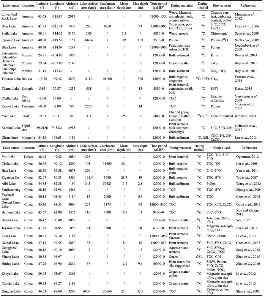
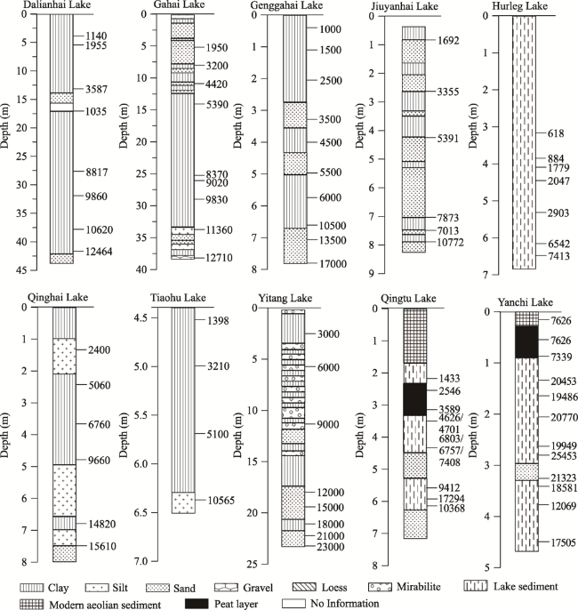
Chen Z, Ma H Z, Cao G C et al., 2007. Climatic-environmental evolution in Gahai Lake area of Qaidam Basin since late last deglacial period. Geochimica, 36: 45‒51. (in Chinese)
Chen C T A, Lan H C, Lou J Y et al., 2003. The dry holocene megathermal in Inner Mongolia. Palaeogeography, Palaeoclimatology, Palaeoecology, 193: 181‒200.
Dean W, Rosenbaum J G, Skipp G et al., 2006. Unusual Holocene and late Pleistocene carbonate sedimentation in Bear Lake, Utah and Idaho, USA. Sedimentary Geology, 185: 93‒112.
Fornace K L, Hughen K A, Shanahan T M et al., 2014. A 60,000-year record of hydrologic variability in the Central Andes from the hydrogen isotopic composition of leaf waxes in Lake Titicaca sediments. Earth and Planetary Science Letters, 408: 263‒271.
Heinecke L, Mischke S, Adler K et al., 2017. Climatic and limnological changes at Lake Karakul (Tajikistan) during the last ~29 cal ka.Journal of Paleolimnology, 58: 317-334.
Kassa T G, 2015. Holocene Environmental History of Lake Chamo, South Ethiopia [D]. Köln: Universität zu Köln.
Kröpelin S, Verschuren D, Lézine A Met al., 2008. Climate-driven ecosystem succession in the Sahara: The past 6000 years. Science, 320: 765‒768.
Lee M K, Lee Y I, Lim, H S et al., 2013. Late Pleistocene-Holocene records from Lake Ulaan, southern Mongolia: Implications for East Asian palaeomonsoonal climate changes. Journal of Quaternary Science, 28: 370‒378.
Li X Q, Liu H B, Zhao K L et al., 2013. Holocene climate and environmental changes reconstructed from elemental geochemistry in the western Hexi Corridor. Acta Anthropologica Sinica, 32: 112‒122. (in Chinese)
Li Y, Wang N A, Li Z L et al., 2012. Basin-wide Holocene environmental changes in the marginal area of the Asian monsoon, northwest China. Environmental Earth Sciences, 65: 203‒212.
Li Y, Wang N A, Li Z L et al., 2013. Climatic and environmental change in Yanchi Lake, northwest China since the late glacial: A comprehensive analysis of lake sediments. Acta Geographica Sinica, 23: 932‒946.
Liu X Q, Dong H L, Rech J A et al., 2008. Evolution of Chaka Salt Lake in NW China in response to climatic change during the Latest Pleistocene-Holocene. Quaternary Science Reviews, 27(7/8): 867‒879.
Liu Y H, Xia D S, Jin M et al., 2012. Holocene environmental change recorded by core magnetic properties of Juyan Lake, northwestern China. Journal of Desert Research, 32(4): 929‒937.
Louderback L A and Rhode D E, 2009. 15,000 Years of vegetation change in the Bonneville basin: The Blue Lake pollen record. Quaternary Science Reviews, 28(3): 0‒326.
Mumma S A, Whitlock C and Pierce K A, 2012. 28,000 year history of vegetation and climate from Lower Red Rock Lake, Centennial Valley, Southwestern Montana, USA. Palaeogeography, Palaeoclimatology, Palaeoecology, 326‒328: 30‒41.
Ogretmen N, Çağatay M N, 2012. Paleoenvironmental changes in Lake Van during the Last Glacial-Holocene. Conference: EGU.
Opitz S, Bernd W, Aichner B et al., 2012. Late glacial and holocene development of Lake Donggi Cona, north-eastern Tibetan Plateau, inferred from sedimentological analysis. Palaeogeography, Palaeoclimatology, Palaeoecology, 337/338: 159‒176.
Roy P D, Caballero M, Lozano R et al., 2010. Geochemical record of Late Quaternary paleoclimate from lacustrine sediments of paleo-lake San Felipe, western Sonora Desert, Mexico. Journal of South American Earth Sciences, 29(3): 586-596.
Roy P D, Quiroz-Jiménez, J D, Chávez-Lara C Met al., 2014. Humid Pleistocene? Holocene transition and early Holocene in sub-tropical northern Mexico and possible Gulf of California forcing. Boreas, 43(3): 577‒587.
Roy P D, Quiroz-Jiménez J D, Pérez-Cruz L Let al., 2013. Late Quaternary paleohydrological conditions in the drylands of northern Mexico: A summer precipitation proxy record of the last 80 cal ka BP. Quaternary Science Reviews, 78: 342‒354.
Scott A R, David F P, Amy M B et al., 2009. A multi-proxy paleolimnological reconstruction of Holocene climate conditions in the Great Basin, United States. Quaternary Research, 72(3): 347-358.
Shen J, Liu X Q, Wang S M et al., 2005. Palaeoclimatic changes in the Qinghai Lake area during the last 18,000 years. Quaternary International, 136(1): 131‒140.
Song L, Qiang M R, Lang L L et al., 2012. Changes in palaeoproductivity of Genggahai Lake over the past 16 ka in the Gonghe Basin, northeastern Qinghai-Tibetan Plateau. China Science Bulletin, 57(20): 2595‒2605.
Verschuren D, Damste J S S, Moernaut J et al., 2009. Half-precessional dynamics of monsoon rainfall near the East African equator. Nature, 462(7273): 637‒641.
Vincens, A, Buchet, G, Williamson, D et al., 2005. A 23,000 yr pollen record from Lake Rukwa (8°S, SW Tanzania): New data on vegetation dynamics and climate in central eastern Africa.Review of Palaeobotany & Palynology, 137(3): 147‒162.
Wang W, Feng Z D, Ran, M et al., 2013. Holocene climate and vegetation changes inferred from pollen records of Lake Aibi, northern Xinjiang, China: A potential contribution to understanding of Holocene climate pattern in East-central Asia. Quaternary International, 311: 54‒62.
Wu D, 2017. Changes of regional hydrology and summer monsoon since the Last Glacial Maximum recorded by Dalianhai Lake, Tibetan Plateau [D]. Lanzhou: Lanzhou University. (in Chinese)
Wu Y H, Lücke A, Wünnemann Bet al., 2007. Holocene climate change in the central Tibetan Plateau inferred by lacustrine sediment geochemical records. Science in China, 50(10): 1548‒1555.
Xue J, Zhong W, 2011. Holocene climate variation denoted by Barkol lake sediments in northeastern Xinjiang and its possible linkage to the high and low latitude climates. Science China(Earth Sciences), 54(4): 135‒146. CNKI:SUN:JDXG.0.2011-04-013.
Yan D D and Wünnemann B,2014. Late Quaternary water depth changes in Hala Lake, northeastern Tibetan Plateau, derived from ostracod assemblages and sediment properties in multiple sediment records. Quaternary Science Reviews, 95: 95‒114.
Zhang C J, Chen F H, Shang M H et al., 2004. The paleoenvironmental significance of organic carbon isotope in lacustrine sediments in the arid China: An example from Sanjiaocheng Palaeolake in Minqin. Quaternary Research, 24(1): 88‒94. (in Chinese)
Zhao C, Yu Z C, Zhao Y et al., 2010. Holocene millennial-scale climate variations documented by multiple lake-level proxies in sediment cores from Hurleg Lake, Northwest China. Journal of Paleolimnology, 44(4): 995‒1008.
Zhao L Y, Lu H Y, Zhang E L et al., 2015. Lake-level and paleoenvironment variations in Yitang Lake (northwestern China) during the past 23 ka revealed by stable carbon isotopic compoition of organic matter of lacustrine sediments. Quaternary Science, 35(1): 172‒179. (in Chinese)
[1]
Allen E D, Spence D H N, 1981. The differential ability of aquatic plants to utilize the inorganic carbon supply in fresh water. New Phytologist, 87(2):269-283.

DOI

[2]
ArchaeoGLOBE Project, 2019. Archaeological assessment reveals Earth’s early transformation through land use. Science, 365(6456):897-902.

DOI

[3]
Balascio N L, D'Andrea W J, Bradley R S et al., 2013. Biogeochemical evidence for hydrologic changes during the Holocene in a lake sediment record from southeast Greenland. The Holocene, 23(10):1428-1439.

DOI

[4]
Berger A L, 1978. Long-term variations of gaily insolation and Quaternary climatic changes. Journal of the Atmospheric Sciences, 35(12):2362-2367.

DOI

[5]
Clark I D, Fritz P, 1997. Environmental Isotopes in Hydrogeology. USA: Lewis Publishers.

[6]
Chen D W, Li Y, Zhang X Z et al., 2020. Study on grains size indicator of surface soil and terminal lake sediments in closed basins over Qilian Mountains. Quaternary Sciences, 40(5):1216-1230. (in Chinese)

[7]
Chen F H, Jia J, Chen J H et al., 2016. A persistent Holocene wetting trend in arid Central Asia, with wettest conditions in the late Holocene, revealed by multi-proxy analyses of loess-paleosol sequences in Xinjiang, China. Quaternary Science Reviews, 146:134-146.

DOI

[8]
Chen F H, Xu Q H, Chen J H et al., 2015. East Asian summer monsoon precipitation variability since the last deglaciation. Scientific Reports, 5:11186.

DOI

[9]
Chen F H, Yu Z C, Yang M L et al., 2008. Holocene moisture evolution in arid Central Asia and its out-of-phase relationship with Asian monsoon history. Quaternary Science Reviews, 27(3/4):351-364.

DOI

[10]
Chen Z Y, Nie Z L, Zhang G H et al., 2006. Environmental isotopic study on the recharge and residence time of groundwater in the Heihe River Basin, northwestern China. Hydrogeology Journal, 14:1635-1651.

DOI

[11]
Crutzen P J, Stoermer E F, 2000. The ‘Anthropocene’. Global Change Newsletters, 41:17-18.

[12]
Dykoski C A, Edwards R L, Cheng H et al., 2005. A high-resolution, absolute-dated Holocene and deglacial Asian monsoon record form Dongge Cave, China. Earth and Planetary Science Letters, 233(1/2):71-86.

DOI

[13]
Fontes J C, Garnier J M, 1979. Determination of the initial 14C activity of the total dissolved carbon: A review of the existing models and a new approach. Water Resources Research, 15(2):399-413.

DOI

[14]
Gates J B, Edmunds W M, Ma J Z et al., 2008. Estimating groundwater recharge in a cold desert environment in northern China using chloride. Hydrogeology Journal, 16(5):893-910.

DOI

[15]
Hu H Y, Xu B S, 2019. Evaluation on irrigated water use efficiency in the Shule River Irrigation District. China Water Resources, 11:53-55. (in Chinese)

[16]
Hu J F, Sha Z J, Ma Y J et al., 2017. Characteristics of grain size and their environmental significance of sediments at the Buha Estuary of the Qinghai Lake. Arid Zone Research, 34(2):445-451. (in Chinese)

[17]
Huang X Z, Liu S S, Dong G H et al., 2017. Early human impacts on vegetation on the northeastern Qinghai-Tibetan Plateau during the middle to late Holocene. Progress in Physical Geography, 41(3):286-301.

[18]
Jin L Y, Chen F H, Morrill C et al., 2012. Causes of early Holocene desertification in arid Central Asia. Climate Dynamics, 38(7/8):1577-1591.

DOI

[19]
Kusakabe M, 2001. A simple method for sampling total dissolved carbonate in carbonate-rich natural waters and CO 2 preparation for δ 13C determination. Geochemical Journal, 35(6):459-464.

DOI

[20]
Lewis S L, Maslin M A, 2015. Defining the Anthropocene. Nature, 519(7542):171-180.

DOI

[21]
Li Y, Li P C, Zhang C Q, 2017a. Long-term fine-grained sediment records in a drainage system in arid China: A new perspective from paleoclimatological records and simulations. Annals of the American Association of Geographers, 107(5):1216-1228.

DOI

[22]
Li Y, Peng S M, Liu H B et al., 2020. Westerly jet stream controlled climate change mode since the Last Glacial Maximum in the northern Qinghai-Tibet Plateau. Earth and Planetary Science Letters, 549:116529.

DOI

[23]
Li Y, Wang N A, Li Z L et al., 2012. Basin-wide Holocene environmental changes in the marginal area of the Asian monsoon, northwest China. Environmental Earth Science, 65:203-212.

DOI

[24]
Li Y, Zhang C Q, Li P C, 2017b. Basin-wide sediment gain-size numerical analysis and paleo-climate interpretation in the Shiyang River drainage basin. Geographical Analysis, 49(13):309-327.

DOI

[25]
Li Y, Zhang C Q, Wang N A et al., 2017c. Substantial inorganic carbon sink in closed drainage basins globally. Nature Geoscience, 10(13):501-508.

DOI

[26]
Liu J B, Chen J H, Zhang X J et al., 2015. Holocene East Asian summer monsoon records in northern China and their inconsistency with Chinese stalagmite δ 18O records . Earth-Science Reviews, 148:194-208.

DOI

[27]
Metcalfe S E, Bimpson A, Courtice A J et al., 1997. Climate change at the monsoon/Westerly boundary in Northern Mexico. Journal of Paleolimnology, 17:155-171.

DOI

[28]
Meyers P A, 1994. Preservation of elemental and isotopic source identification of sedimentary organic matter. Chemical Geology, 114(3/4):289-302.

DOI

[29]
O'Leary M H, 1988. Carbon isotopes in photosynthesis. Bioscience, 38(5):328-336.

DOI

[30]
Park J, Byrne R, Böhnel H et al., 2010. Holocene climate change and human impact, central Mexico: A record based on maar lake pollen and sediment chemistry. Quaternary Science Reviews, 29(5/6):618-632.

DOI

[31]
Pearson F J, White D E, 1967. Carbon 14 ages and flow rates of water in Carrizo sand, Atascosa County, Texas. Water Resources Research, 3(1):251-261.

DOI

[32]
Qi S Z, Luo F, 2005. Water environmental degradation of the Heihe River Basin in arid northwestern China. Environmental Monitoring & Assessment, 108:205-215.

[33]
Qiang M R, Song L, Jin Y X et al., 2017. A 16-ka oxygen-isotope record from Genggahai Lake on the northeastern Qinghai-Tibetan Plateau: Hydroclimatic evolution and changes in atmospheric circulation. Quaternary Science Reviews, 162:72-87.

DOI

[34]
Rodell M, Famiglietti J S, Wiese D N et al., 2018. Emerging trends in global freshwater availability. Nature, 557(7707):651-659.

DOI PMID

[35]
Ruan Y F, Zhao L J, Xiao H L et al., 2015. The groundwater in the Heihe River Basin: Isotope age and renewability. Journal of Glaciology and Geocryology, 37(3):767-782. (in Chinese)

[36]
Shen J, Liu X Q, Wang S M et al., 2015. Palaeoclimatic changes in the Qinghai Lake area during the last 18,000 years. Quaternary International, 136(1):131-140.

DOI

[37]
Siebert S, Burke J, Faures J M et al., 2010. Groundwater use for irrigation: A global inventory. Hydrology and Earth System Sciences, 7(3):1863-1880.

[38]
Stuiver M, Groots P M, Braziunas T F, 1995. The GISP2 δ18O climate record of the past 16,500 years and the roles of the sun, ocean and volcanoes. Quaternary Research, 44(3):341-354.

DOI

[39]
Stuiver M, Reimer P J Reimer R W, 2019. CALIB 7.1 [WWW program] at http://calib.org, accessed 2019-11-11.

[40]
Steffen W, Grinevald J, Crutzen J P et al., 2011. The Anthropocene: Conceptual and historical perspectives. Philosophical Transactions of the Royal Society A: Mathematical, Physical and Engineering Sciences, 369(1938):842-867.

[41]
Unterman M B, Crowley T J, Hodges K I et al., 2011. Paleometeorology: High resolution Northern Hemisphere wintertime mid-latitude dynamics during the Last Glacial Maximum. Geophysical Research Letters, 38(23):563-567.

[42]
Vogel J C, 1970. Carbon 14 Dating of Groundwater, Isotope Hydrology. Vienna: IAEA,225-239.

[43]
Wallerstein I, 2011. The Modern World-System I: Capitalist Agriculture and the Origins of the European World-Economy in the Sixteenth Century. University of California Press.

[44]
Wang J D, Song C Q, Reager J T et al., 2018. Recent global decline in endorheic basin water storages. Nature Geoscience, 11:926-932.

DOI

[45]
Wang N A, Zhao Q, Hu G et al., 2003. Climatic and humanistic background of desertification process in the recent 2000 years in Hexi Corridor, China. Journal of Desert Research, 23(1):95-100. (in Chinese)

[46]
Wang S P, Jia G D, Zhao Y et al., 2010. Plant wax n-alkanse record of the Holocene paleoclimatic changes from a core sediment of Hurleg lake in the Qaidam Basin. Quaternary Sciences, 30(6):1097-1104. (in Chinese)

[47]
Wang W, Feng Z D, Ran M et al., 2013. Holocene climate and vegetation changes inferred from pollen records of Lake Aibi, northern Xinjiang, China: A potential contribution to understanding of Holocene climate pattern in East-central Asia. Quaternary International, 311:54-62.

DOI

[48]
Wassenburg J A, Dietrich S, Fietzke J et al., 2016. Reorganization of the North Atlantic Oscillation during early Holocene deglaciation. Nature Geoscience, 9(8):602-605.

DOI

[49]
Xiao X Y, Haberle S G, Shen J et al., 2014. Latest Pleistocene and Holocene vegetation and climate history inferred from an alpine lacustrine record, northwestern Yunnan Province, southwestern China. Quaternary Science Reviews, 86:35-48.

DOI

[50]
Xiao Y, 2018. Groundwater circulation patterns and its change trend in southern Qaidam Basin, northwest China[D]. Beijing: China University of Geosciences (Beijing) (in Chinese)

[51]
Xu J, Zhang B P, Zhu Y et al., 2006. Distribution and geographical analysis of altitudinal belts in the Altun-Qilian Mountains. Geographical Research, 25(6):977-984. (in Chinese)

[52]
Yan D D, Wünnemann B, 2014. Late Quaternary water depth changes in Hala Lake, northeastern Tibetan Plateau, derived from ostracod assemblages and sediment properties in multiple sediment records. Quaternary Science Reviews, 95:95-114.

DOI

[53]
Yang Y S, Dong G H, Zhang S J et al., 2016. Copper content in anthropogenic sediments as a tracer for detecting smelting activities and its impact on environment during prehistoric period in Hexi Corridor, Northwest China. The Holocene,1-10.

[54]
Zalasiewicz J, Williams M, Fortey R et al., 2011. Stratigraphy of the Anthropocene. Philosophical Transactions Mathematical Physical & Engineering Sciences, 369(1938):1036-1055.

[55]
Zhang C, Zhao C, Zhou A F et al., 2019. Late Holocene lacustrine environmental and ecological changes caused by anthropogenic activities in the Chinese Loess Plateau. Quaternary Science Reviews, 203:266-277.

DOI

[56]
Zhao Y, Wu F L, Fang X M et al., 2015. Topsoil C/N ratios in the Qilian Mountains area: Implications for the use of subaqueous sediment C/N ratios in paleo-environmental reconstructions to indicate organic sources. Palaeogeography, Palaeoclimatology, Palaeoecology, 426:1-9.

DOI

[57]
Zhu G F, Su Y H, Feng Q, 2008. The hydrochemical characteristics and evolution of groundwater and surface water in the Heihe River Basin, northwest China. Hydrogeology Journal, 16:167-182.

DOI

Outlines

/