Spatial pattern and driving factors of migrants on the Qinghai-Tibet Plateau: Insights from short-distance and long-distance population migrants

  • QI Wei , 1, 2, 4 ,
  • YI Jiawei , 1, 3, 4, *
Expand
  • 1. Institute of Geographic Sciences and Natural Resources Research, CAS, Beijing 100101, China
  • 2. Key Laboratory of Regional Sustainable Development Modeling, CAS, Beijing 100101, China
  • 3. State Key Laboratory of Resources and Environmental Information System, CAS, Beijing 100101, China
  • 4. University of Chinese Academy of Sciences, Beijing 100049, China
*Yi Jiawei (1988-), PhD and Associate Professor, specialized in spatiotemporal data mining. E-mail:

Qi Wei (1989-), Associate Professor, specialized in urban geography and population geography. E-mail:

Received date: 2020-03-21

  Accepted date: 2020-09-15

  Online published: 2021-04-25

Supported by

The Strategic Priority Research Program of Chinese Academy of Sciences, Pan-Third Pole Environment Study for a Green Silk Road (Pan-TPE)(XDA20040401)

The Second Tibetan Plateau Scientific Expedition and Research Program (STEP)(2019QZKK1005)

National Natural Sciences Foundation of China(41701165)

Copyright

Copyright reserved © 2021. Office of Journal of Geographical Sciences All articles published represent the opinions of the authors, and do not reflect the official policy of the Chinese Medical Association or the Editorial Board, unless this is clearly specified.

Abstract

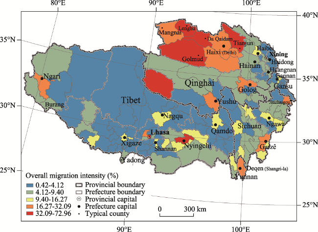
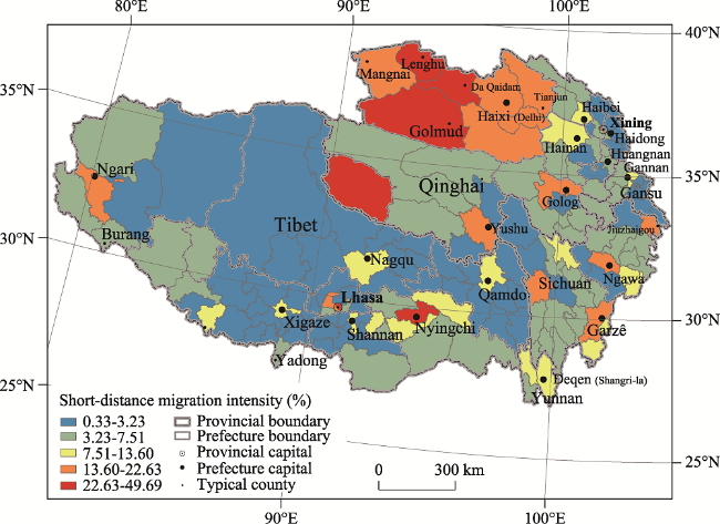
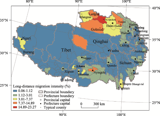
As one of the most ecologically sensitive issues in the world, migration now plays an important role in population growth on the Qinghai-Tibet Plateau. To promote sustainable development in the world’s third pole, it is necessary to investigate population migration on the Plateau. Using 2010 census data, a spatial database of county-level migrants on the Plateau was constructed, and migrants were divided into short-distance and long-distance migrants according to the hukou-registered origins. Measuring migration intensity allowed the spatial pattern of population migration on the Plateau to be ascertained. The driving factors were identified using spatial regression models, and the main conclusions are as follows: (1) In 2010, there were 1.23 million inter-county migrants on the Qinghai-Tibet Plateau, and the overall migration intensity reached 10.50%. There existed significant spatial differences in population migration intensity on the Plateau at that time, and the provincial or prefectural capitals were attractive destinations for migrants. Northwestern Qinghai, which boasted mining industries, constituted a significant spatial cluster with a relatively high migration intensity. However, most areas on the Plateau attracted relatively few migrants, especially in western and northern parts of Tibet, which were sparsely populated and uninhabitable. (2) There were 0.95 million short-distance migrants and 0.28 million long-distance migrants. The short-distance migration intensity was 8.14%, while the long-distance migration intensity was only 2.36%. Short-distance migration was the main form of population migration, with a pattern similar to the layout of overall population migration intensity. Only a few county-level units strongly attracted long-distance migrants, which were mostly distributed in northwestern Qinghai. (3) Economic factors were considered fundamental drivers for migrants to live on the Plateau. Destinations with high levels of economic development and more opportunities in non-agricultural jobs proved more attractive for migrants. For short-distance migrants, urbanization level also proved a considerable driving factor for in-migration. However, long-distance migrants were mainly affected by the job chances of the secondary industry on the Qinghai-Tibet Plateau.

Cite this article

QI Wei , YI Jiawei . Spatial pattern and driving factors of migrants on the Qinghai-Tibet Plateau: Insights from short-distance and long-distance population migrants[J]. Journal of Geographical Sciences, 2021 , 31(2) : 215 -230 . DOI: 10.1007/s11442-021-1843-y

1 Introduction

As the third pole on the earth, the Qinghai-Tibet Plateau is an area characterized by sparse population both from a Chinese and global perspective (Liao et al., 2003). Because of its arctic-alpine environment and fragile ecosystems, the Plateau is regarded as one of the most uninhabitable areas for human beings. Human occupation of the Plateau started at least 2100 years ago (Zhao et al., 2009), and because the population was kept at a low level and the inhabitants respected the fragile ecosystems, their presence caused little disruption (Shen et al., 2012; Qi et al., 2016; Cao and Dong, 2020). However, with modernization and urbanization, the population on the Qinghai-Tibet Plateau has increased dramatically during the past several decades (Liao et al., 2003; Fan et al., 2010). According to the Statistical Yearbook of China, the Tibet autonomous region only possessed 1.14 million residents in 1951 when it was established. Nevertheless, 3.43 million people resided in Tibet at the end of 2018, a tripling of the initial number over 67 years. Qinghai is another major province on the Plateau, with its fivefold population in 2018, according to a comparison of the national founding era in 1949. One of the key reasons was the relatively high natural population growth of local people, related to China’s preferential birth policy in ethnic-minority areas (Deng et al., 2015). Another key reason was an increase in in-migrants on the Plateau. With improvements in transportation systems, including railways, highways, and aviation, people around the world traveled with greater ease to the Qinghai-Tibet Plateau (Su, 2009). Population migration has increased significantly on the Plateau during the past few decades. According to the latest 1% population survey in 2015, the number of internal in-migrants in Tibet and Qinghai reached 0.40 million and 0.84 million, respectively. Notably, an increasing number of migrants have provoked concern because they contributed to the human footprints and consumed natural resources, placing environmental pressure on the third pole (Cheng et al., 2000; Du, 2004; Li et al., 2018). At present, the National Second Scientific Investigation of the Qinghai-Tibet Plateau is in progress, with emphasis on the impact of human activity. As a basic form of human activity, it is necessary to elucidate the mechanism of population migration to the Qinghai-Tibet Plateau—why do people migrate to this relatively uninhabitable place? How did they choose the destination? What were the attractions for migrants on the Qinghai-Tibet Plateau?
Numerous studies have focused on population migration in China; however, few have investigated population migration on the Qinghai-Tibet Plateau. Using a population census and survey data, the spatial patterns of China’s internal population migration in different periods were studied. Almost all studies showed a powerful population attraction in coastal areas or megacities (Shen, 1999; Fan, 2008; Chan, 2012; Li et al., 2014; Liang et al., 2014). Factors such as socioeconomic factors, the distance and institutions have been identified as the main drivers of population migration in China (Fan, 2005; Shen, 2013; Tan et al., 2016; Liu et al., 2017). However, most of them did not highlight population migration on the Qinghai-Tibet Plateau; the main reason for this may be that the migrant flux was significantly lower compared with other large flows. Migration related to the Plateau was always not striking in the system of China’s internal population migration. Studies that have specialized in migration on the Qinghai-Tibet Plateau have mainly been case studies. For instance, Clarke presented the history of population movement in Tibet and Qinghai (Clarke, 1994). Hu presented the relationship between migrants and the local market in Lhasa, the provincial capital of Tibet (Hu, 2004). Wang et al. (2010) investigated ecological migrants in the sources of the Yangtze, Yellow, and Lancang rivers, Qinghai. Xiao et al. (2014) explored the population migration trend in northern Tibet. Some case studies have investigated the ecological and environmental impacts of population change, such as energy consumption, air pollution, and ecosystem services, on the Plateau (Liu et al., 2008; Ye et al., 2020; Sun et al., 2020). However, there is still a lack of studies on the overall pattern and dynamics of population migration on the Qinghai-Tibet Plateau, especially for the period of rapid economic development in China. Along with China’s “western development strategy” and “the Belt and Road Initiative,” increasing numbers of modern industries, including international trade, plateau tourism, modern agriculture, and animal husbandry, are materializing on the Plateau, increasing its migrant footprint. Moreover, the Chinese government promotes in-suit urbanization in western China as part of a new urbanization strategy (Taylor, 2015). “In-suit” indicates geographical proximity, which is important in short-distance population movement on the Plateau. Hence, there is obvious motivation to investigate population migration on modern-day Qinghai-Tibet Plateau from the perspective of short-distance and long-distance migrants.
This paper presents the spatial pattern and driving factors of population migration on the Qinghai-Tibet Plateau. Both short-distance and long-distance population migrations are defined and investigated in the study. The remainder of this paper is organized as follows. Section 2 covers the methodology, which involves the study area, definition of migrants, measure of migration intensity, spatial regression models, and data sources. Section 3 presents the research results of spatial differences and driving factors of population migration in the Plateau. Sections 4 and 5 are the discussion and conclusions, respectively. The study focuses on data from 2010, when the sixth population census was conducted. For simplification, the expression “provinces” is applied to represent provincial units, including provinces, autonomous regions of ethnic minorities, and municipalities.

2 Methodology

2.1 The study area

From the perspective of natural geography, the Qinghai-Tibet Plateau covers the whole Tibet Autonomous Region, most parts of Qinghai, as well as some parts in Sichuan, Yunnan, Gansu, and Xinjiang. In Figure 1, we adopt the standardized area put forward by Zhang et al. as the natural boundary of the Qinghai-Tibet Plateau (Zhang et al., 2002; Zhang et al., 2016). However, the social and economic data were usually collected and counted based on administrative division boundaries, which do not correspond exactly with natural boundaries; hence, we use intact administrative division areas. The study area of the Qinghai-Tibet Plateau includes two provincial-level units and four prefectural-level units: the Tibet Autonomous Region, Qinghai Province, the Garzê Tibetan Autonomous Prefecture in Sichuan Province, the Ngawa Tibetan and Qiang Autonomous Prefecture in Sichuan Province, the Deqen Tibetan Autonomous Prefecture in Yunnan Province, and the Gannan Tibetan Autonomous Prefecture in Gansu Province. The study area not only covers most of the population and the majority of settlements on the Qinghai-Tibet Plateau, but also considers the traditional region of Tibetan home. The northern areas of the Qinghai-Tibet Plateau are mainly the depopulated zones, which are excluded from the study area.
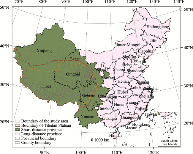
Figure 1 Location of the study area (Qinghai-Tibet Plateau)

(Note: The red boundary indicates the boundary of the Qinghai-Tibet Plateau, in terms of natural geography. The orange boundary shows the study area with the application of the intact administrative division areas of the Qinghai-Tibet Plateau. Green represents short-distance provinces, while pink represents long-distance provinces relative to Qinghai-Tibet Plateau)

The county level is adopted as the basic study scale because the definitions and regulating policies of population migration are mainly based on inter-county levels in China. According to the administrative division system in China, county-level units on the Qinghai-Tibet Plateau include counties (“xian”), county-level cities (“xianjishi”), executive committees (“zhixingwei”), and municipal districts (“shixiaqu”). County-level cities usually consist of units with high urbanization development, such as capitals of prefectures. In addition to normal counties, executive committees, including Da Qaidam, Mangnai, and Lenghu, are county-level units rooted in the industrialization of planning economy. For municipal districts, all districts in a city are merged to create a whole county-level unit, which creates a merged-district city.

2.2 Definition of migrants

There are several ways to define population migration. For example, the lifetime, five-year ago and latest migrations are defined in accordance with place of birth, residential places five years ago and the last residential places, respectively. In China, another definition is widely utilized, called non-hukou population migration (Chan et al., 1999). Hukou is considered as a permit for people to enjoy public services in a place. However, many migrants, on account of restricted conditions, usually do not possess hukou in the destination. Thus, they are considered a “floating population” (Liu et al., 2011). According to the report of the National Bureau of Statistics of China in 2018, the number for the floating population reached 241 million, comprising 17.27% of China’s population. Hence, we used the floating population to define migrants in our study, with the origin being the hukou-registered county and the destination being the residential place. Because the county level is the basic scale in our study, intra-county population movement is ignored.
In order to explore differences in population migration in terms of spatial proximity, definitions for short-distance migrants and long-distance migrants is given. As the name implies, short-distance migrants mainly migrate from adjacent regions, while long-distance migrants mainly migrate from distant regions. Because the origin-to-destination matrix of population migration in China was only available for the inter-provincial scale, we define migrants from provinces close to the Qinghai-Tibet Plateau (including Tibet, Qinghai, Xinjiang, Sichuan, Gansu, and Yunnan) as short-distance migrants. The inter-county migrants from these provinces are regarded as short-distance migrants. Conversely, migrants from other provinces are defined as long-distance migrants for Qinghai-Tibet Plateau. Figure 1 shows the short-distance and long-distance origins of migrants.

2.3 Measures of migration intensity

To describe the spatial distribution of migrants on the Qinghai-Tibet Plateau, we introduce the classic measure of migration intensity as an indicator of migrant attraction (Bell et al., 2015). The calculation formula is as follows:
$I_{i}^{{}}=\frac{M_{i}^{{}}}{P_{i}^{{}}}$
where $I_{i}^{{}}$ represents migrant intensity at unit i, equal to the share of migrant. ${{M}_{i}}$ and ${{P}_{i}}$ represent the number of migrants and the total population of unit i, respectively.
Accordingly, we extend formula (1) to measure the intensities of short-distance and long-distance population migration. The calculation formula is as follows:
$I_{i}^{{}}=I_{i}^{s}\text{+}I_{i}^{l}\text{=}\frac{M_{i}^{s}}{P_{i}^{{}}}+\frac{M_{i}^{l}}{P_{i}^{{}}}$
where $I_{i}^{s}$ and $I_{i}^{l}$ denote short-distance and long-distance migrant intensities of unit I, respectively. $M_{i}^{s}$and $M_{i}^{l}$ represent the number of short-distance and long-distance migrants of unit i, respectively. $M_{i}^{s}$includes both intra-provincial migrants and inter-provincial migrants from Tibet, Qinghai, Xinjiang, Sichuan, Gansu, and Yunnan.

2.4 Spatial regression models

To elucidate migrant distribution on the Plateau, we apply spatial regressions, including spatial lag regression and spatial error regression, to identify migration drivers (Anselin et al., 2006). Compared to the OLS model, the spatial regression model considers the spatial spillover effects of the neighbors. The spatial lag regression model is described as follows:
$y=\rho Wy+X\beta +\varepsilon $
$\varepsilon \tilde{\ }N(0,{{\delta }^{2}}{{I}_{n}})$
where y represents the dependent variable and X the independent variables, or explanatory variables; W represents a spatial weight matrix; β and ρ the function of independent variables and the spatial spillover effects of y, respectively; and ε white noise. In comparison, the formula for the spatial error model is:
$y=X\beta +\mu$
$\mu =\rho W\mu +\varepsilon $
$\varepsilon \tilde{\ }N(0,{{\delta }^{2}}{{I}_{n}})$
where the variables have the same meanings as those in formula (3). The modeling results can be tested using the natural log likelihood value, Akaike information criterion, Schwarz criterion, and the R-squared value. In order to determine the best model, it is necessary to compare the values between Robust LM (lag) and Robust LM (error). When one of them is significant and the other is not, the significant one is selected as the more suitable model. If they are equally significant, the larger Robust LM is preferred as a reference for the choice.
In this study, we focus on socioeconomic driving factors for population migration in the Plateau. One should be aware that economic attraction is the main motivation for migrant workers. We adopt per capita GDP to indicate the general economic development level. Additionally, the proportion of occupied population in secondary and tertiary industries is used to represent the underlying attractive capability of off-farm employment opportunities. Migrants are also motivated by social welfare, especially in education and medical care. We thus adopt the education level per capita and the average number of hospital beds per ten thousand people to reflect the education level and medical level, respectively. Furthermore, the fact that all migrants aspire to a better life, especially in cities and the towns, justifies the above mentioned. Hence, the urbanization level is applied to represent urban lifestyle.

2.5 Data sources

The most up-to-date in-migrant data at county level are only available from the 2010 sixth population census. The National Bureau of Statistics of China published the sum data of migrants, including numbers of the intra-county, intra-provincial, and inter-provincial migrants in each county-level unit. However, in order to distinguish between the short-distance and long-distance migrants, the number of inter-provincial migrants from different provinces is necessary, which is only available from the tabulations published by each province or each prefecture. Migrant data classified by origin province, i.e., Qinghai, Gansu, and Yunnan, can be directly acquired from the census tabulations of Qinghai Province, Gansu Province, and Yunnan Province, while the related data for Sichuan and Tibet need to be collected from prefecture census tabulations. Because the merged-district cities are regarded as whole administrative units, the number of intra-provincial migrants in these cities is equal to the number of intra-provincial migrants minus the number of intra-municipal-district migrants. The socioeconomic data for 2010 are from the China Statistical Yearbook for Regional Economy 2011 and the Statistical Yearbook 2011 in each province. All the geographic data are provided by the National Earth System Science Data Sharing Infrastructure in China. Through a combination of demographic and socioeconomic data with data from the county-level administrative units, a spatial database is constructed. In terms of the study area, the database contains 158 county-level units.

3 Results

3.1 General statistics for migrants on the Qinghai-Tibet Plateau

According to the statistics in Table 1, in 2010 there was 1.23 million inter-county migrants on the Qinghai-Tibet Plateau, including 0.95 million short-distance migrants and 0.28 million long-distance migrants—the number of short-distance migrants was 3.5 times the number of long-distance migrants. The overall migration intensity reached 10.50%, indicating that population migration had reached a considerable level on the Plateau. Specifically, the short-distance migration intensity was 8.14%, while the long-distance migration intensity was only 2.36%. In addition, the gap between short-distance and long-distance migration intensities was also significant from the perspective of the maximum and the minimum values in the 158 county-level units in the study area. Both the maximum and minimum values of short-distance migration intensity were larger than those of long-distance migration intensity, again demonstrating the advantages of short-distance population migration on the Qinghai-Tibet Plateau. Using the variable coefficient of migration intensity and a statistical indicator of values’ difference highlights that differences in long-distance migration intensity among all the county-level units were distinctly larger than those of short-distance migration.
Table 1 Basic statistics of migrants on the Qinghai-Tibet Plateau in 2010
Statistical indices All migrants Short-distance migrants Long-distance migrants
Number of migrants (person) 1229500 953544 275956
General migration intensity (%) 10.50 8.14 2.36
Max value of migration intensity (%) 72.96 49.69 23.27
Min value of migration intensity (%) 0.42 0.33 0.06
Variable coefficient of migration intensity 1.32 1.24 1.81
On the Qinghai-Tibet Plateau, short-distance migrants generally predominated in inter-county migration, mainly coming from such provinces as Tibet, Qinghai, Sichuan, Yunnan, Gansu, and Xinjiang. For long-distance migration, there existed apparent gaps in population migration intensity among different county-level units.

3.2 Spatial pattern of migration intensity on the Qinghai-Tibet Plateau

Figure 2 shows all county-level units classified into five hierarchies based on overall migration intensity. A natural break called Jenks was applied as a classification method because it showed the relative values in the hierarchical system. The county-level units in the top hierarchy numbered only six: Lhasa, Nyingchi, Golmud, Da Qaidam, Lenghu, and Tianjun. Lhasa is the provincial capital of Tibet, and Nyingchi the prefectural capital. Nyingchi, Golmud, and Da Qaidam were all notable for their mining industries, providing many secondary industry jobs for migrants. Tianjun was a county characterized by relatively developed stock farming and coal mining. Additionally, the second hierarchy covered 11 county-level units, such as Xining, the provincial capital of Qinghai. Some prefectural capitals, including Yushu, Kangding, Shangri-la, and Maqen, also had a relatively high migration intensity. In addition to the above capitals, the counties in northwest Qinghai, including Mangnai, Delhi, Dulan, and Ulan, all belonged to the second hierarchy. As for the third, or medium hierarchy, 19 county-level units were included, most of them the prefectural capitals or the counties close to Sichuan-Tibet arterial traffic. In terms of the counties in the fourth hierarchy, the distribution of primary areas was evident in the western and northern parts of the Qinghai-Tibet Plateau, relatively close to the interior areas of China. Moreover, some counties located on the national boundary were also listed in the fourth hierarchy, such as Yadong, Medog, Burang, and Zanda; and in the fifth hierarchy, most counties were included, with little attraction for migrants. Most of them were located in the hinterland of Tibet and eastern Qinghai.
Figure 2 Spatial distribution of overall migration intensity on the Qinghai-Tibet Plateau in 2010
In sum: firstly, most county-level units with a higher migration intensity were provincial or prefectural capitals. Secondly, there existed a spatial cluster of high migration intensity in northwestern Qinghai, where many mining cities and towns were located. Furthermore, adjacent counties close to eastern Sichuan, central Gansu, and eastern Yunnan usually had a higher migration intensity compared with counties in western Tibet. In addition, the vast area with minimal migrant attraction located in western and northern Tibet is sparsely-populated and uninhabitable.

3.3 Spatial differences between short-distance and long-distance migration intensities

According to Figures 3 and 4, using Jenks natural break, all the county-level units were classified into five hierarchies based on short-distance and long-distance migration intensities respectively. Clearly, the classification of hierarchies in Figure 3 is quite similar to that in Figure 1, indicating that short-distance migration played a key role in the spatial distribution of migrants on the Qinghai-Tibet Plateau. However, the spatial patterns of the five hierarchies in Figure 3 are quite different compared with those of Figures 1 and 4. County-level units with a relatively large long-distance migration intensity in the top two hierarchies were mainly distributed in northwestern Qinghai, where the advantages of mining industries were distinct. Moreover, Xining, the provincial capital of Qinghai, and Nyingchi, a prefectural capital, exhibited relatively strong attraction for remote migrants. For the third, or medium, hierarchy of long-distance migration intensity, most of county-level units were also distributed in northwestern Qinghai. Lhasa, the provincial capital of Tibet, was also assigned to this hierarchy. Nevertheless, for most county-level units on the Qinghai-Tibet Plateau, they all were in absence of the attraction for long-distance migrants.
Figure 3 Spatial distribution of short-distance migration intensity on the Qinghai-Tibet Plateau in 2010
Figure 4 Spatial distribution of long-distance migration intensity on the Qinghai-Tibet Plateau in 2010
To sum up, the spatial distributions for short-distance and long-distance migration intensities were quite different. In terms of migration intensity, in most areas of the Qinghai-Tibet Plateau, short-distance migrants clearly predominated. Only a few county-level units strongly attracted long-distance migrants, mostly distributed in northwestern Qinghai. For most areas on the Qinghai-Tibet Plateau, especially those counties which were not prefecture-level or provincial-level capitals, there was a lack of attraction to people from remote places.

3.4 Driving factors of short-distance and long-distance migration on the Qinghai-Tibet Plateau

Table 2 shows that by using OLS, spatial lag, and spatial error regression models, the functions for socioeconomic driving factors are derived. For the overall migration intensity, the spatial error model presented a high R-squared value. In addition, the value of Robust LM (error) was larger than that of Robust LM (lag). Therefore, the spatial error model was the best of the three regression models for overall migration intensity. For the economic development model, job opportunities in both the secondary and tertiary industries were considered as the significant explaining variables; while urbanization level and social influence factors were unimportant, reflecting migration to the Qinghai-Tibet Plateau because of economic as opposed to social attraction.
Table 2 Regression results of migration intensities on the Qinghai-Tibet Plateau in 2010
Explaining variables and regression
test variables
Explained variables
Overall
migration intensity
Short-distance
migration intensity
Long-distance
migration intensity
OLS
Constant -2.29* -1.95** -0.33
Economic development level 0.93*** 0.84*** 0.09
Secondary industry job opportunities 0.37*** 0.20*** 0.17***
Tertiary industry job opportunities 0.15** 0.12*** 0.03*
Urbanization level 0.08 0.08* -0.003
Education level 0.005 0.003 0.001
Medical level 0.01 0.02 -0.005
R2 0.766 0.761 0.711
Spatial lag
Constant -0.06* -1.84* -0.22
Economic development level 0.95*** 0.85*** 0.11
Secondary industry job opportunities 0.39*** 0.21*** 0.19***
Tertiary industry job opportunities 0.14** 0.12*** 0.02
Urbanization level 0.08 0.08* 0.0003
Education level 0.005 0.003 0.001
Medical level 0.01 0.02 -0.005
W_y -1.96 -0.02 -0.15
R2 0.767 0.762 0.717
Robust LM (lag) 4.88* 4.21 6.22*
Spatial error
Constant -2.33* -2.04** -0.34
Economic development level 0.90*** 0.82*** 0.09
Secondary industry job opportunities 0.38*** 0.21*** 0.17***
Tertiary industry job opportunities 0.16*** 0.13*** 0.03
Urbanization level 0.08 0.08* -0.002
Education level 0.004 0.003 0.001
Medical level 0.01 0.02 -0.005
LAMBDA 0.11 0.17 -0.04
R2 0.768 0.767 0.711
Robust LM (error) 5.13 7.12** 2.44

Note: (a) ***, **, and * mean that differences are significant at the 0.001 level, the 0.01 level, and the 0.05 level, respectively. (b) Italic variables are regression test variables. (c) Economic level, secondary industry job opportunities, tertiary industry job opportunities, urbanization level, education level, and medical level are measured by GDP per capita, share of employed persons of secondary industry, share of employed persons of tertiary industry, share of urban population, average educational year, and average number of hospital beds per ten thousand persons, respectively.

Table 2 shows that there exists distinct differences in driving factors between short-distance and long-distance migration intensities. For short-distance migration intensities, according to the R-squared and Robust LM (error) values, the spatial error model is the most suitable. In addition to economic factors, the short-distance migrants were also susceptive to urbanization level. Generally, places with a higher level of urbanization, including provincial and prefectural capitals, were the desired destinations of short-distance migrants. However, for long-distance migration intensity, according to the R-squared and Robust LM (lag) values, the spatial lag model was the most suitable. Only secondary industry job opportunities proved to be a significant driver for long-distance migration intensity on the Qinghai-Tibet Plateau. This explains why so many long-distance migrants migrated to northwestern Qinghai, where relatively advanced mineral industries existed on the Plateau.
Generally, economic driving factors should be regarded as the primary motivation for people migrating to the Qinghai-Tibet Plateau; these factors, including high levels of economic development and greater numbers of non-agricultural jobs, preferentially attract migrants. For short-distance migrants, urbanization level is carefully considered in pursuit of a better life in urban areas. However, for long-distance migrants, the only significant attraction is the number of secondary industry job opportunities on the Plateau. To a large extent, the driving factors just discussed and explained the spatial patterns of overall short-distance and long-distance migration intensities.

4 Discussion

4.1 Division of short-distance and long-distance population migration

Our study necessitated a clear division between short-distance and long-distance population migration. The classification of migrants by geographic range elucidated the effects of distance on migrant attraction on the Qinghai-Tibet Plateau. We found differences between short-distance and long-distance population migrations embedded in spatial patterns and driving factors. Unlike coastal areas or megacities in China, the Qinghai-Tibet Plateau clearly was not a popular destination for migrants due to its relatively uninhabitable environment and less well developed socioeconomic conditions. Therefore, most migrants on the Qinghai-Tibet Plateau were short-distance migrants, not only on account of the short distance between destinations and hometowns, but also the adaptive capacity in such cold and arid regions. It can thus be concluded that the special natural environment and cultural community were critical deciding factors in whether short-distance migration occurred on the Qinghai-Tibet Plateau. For example, it was common to find migrants from Sichuan and Gansu who worked in the catering, hotel, and driving industries. Only a few areas were attractive to long-distance migrants, and most of these were concentrated in the provincial capitals, prefectural capitals, and the industrial and mining places. Additionally, northwestern Qinghai had the most eye-catching spatial cluster for both short-distance and long-distance migrants after it changed from a sparsely populated area into a popular destination for migrants due to mineral resources available from the 1950s. Nevertheless, because information on migration origins was only accessible at the provincial scale, our division between short-distance and long-distance population migrations was based on the provincial boundaries on the Qinghai-Tibet Plateau. For other related studies, such divisions could also refer to physical distance, transportation distance, and the spatial relationships among neighbors (Long, 1998; Bell et al., 2002; Biagi et al., 2011; Niedomysl, 2011; Niedomysl et al., 2017).

4.2 Limitations of driving factor analysis

In our study, because of data availability, we selected only some possible representative socioeconomic factors that affected the spatial distribution of migrants on the Qinghai-Tibet Plateau. Similar to most motivations for migration worldwide, population migration onto the Qinghai-Tibet Plateau was mainly due to economic driving factors. However, the mechanism of population migration in different places may vary. For example, provincial and prefectural capitals were attractive on account of job opportunities in catering, hotel, and driving businesses; but the counties closest to national boundaries, including Yadong, Nyalam, and Burang, offered job opportunities in international trade. Moreover, counties adjacent to scenic zones, including Jiuzhaigou and Shangri-la, provided plenty of job opportunities in tourism. In addition, environmental and ecological factors were considered crucial in the urbanization of the Qinghai-Tibet Plateau; this was inferred from socioeconomic factors, in that most relatively well developed places were habitable areas with relatively better natural conditions for people to live in. For example, the provincial capitals and the prefectural capitals were mostly distributed in valley areas or flat ground. Qingtang, the famous depopulated zone located on the western Qinghai-Tibet Plateau, had the lowest attraction for migrants. In short, similar to many other studies on migrants in large cities, more field work and detailed investigation should be done to ascertain the spatial diversity of migration on the Qinghai-Tibet Plateau.

4.3 Policy implications

A key finding of our study is that short-distance migration was the main type of population migration on the Qinghai-Tibet Plateau. Short-distance migration was not only affected by economic factors but also by urbanization level. Nevertheless, education and medical conditions were not significant driving factors of migration. China now actively promotes local and adjacent urbanization in central and western regions. As modernization continues apace on the Qinghai-Tibet Plateau, increasing the numbers of off-farm employment have appeared in a short time. Moreover, people prefer to move to places with relatively high urbanization levels. Therefore, it is crucial to enhance social welfare for the benefit of migrants, including education and medical care. Meanwhile, social urbanization should catch up with economic development and population urbanization to maintain a balance in that region. The associated benefits are undoubtedly essential for urbanization of the Qinghai-Tibet Plateau from both quantitative and qualitative perspectives.
Moreover, the spatial distribution of migrants on the Qinghai-Tibet Plateau has been quite unbalanced, with a tendency of most of migrants to stay in the provincial capitals, prefectural capitals, and similar places which boast the advantages of mineral industries. It is necessary to seek a balance in the relationship between growth of population and natural resource preservation, such as water supplies in arid areas and land supply in valley areas. As an ecologically sensitive area, it is necessary to highlight the potential impact of migration on the local environment. More attention should be paid to sewage disposal, solid waste pollution, public toilet sanitation, automobile exhaust, and soil contamination in the popular migration destinations of the Qinghai-Tibet Plateau. In addition, in-migrants, especially long-distance migrants with a distinctive culture and lifestyle, should be encouraged to respect the local ecology and natural environment of the Qinghai-Tibet Plateau.

5 Conclusions

Using 2010 census data, a spatial database of county-level migrants on the Qinghai-Tibet Plateau is constructed. Migrants were classified into short-distance and long-distance migrants, according to their hukou-registered origins. By applying the measure of migration intensity, the spatial pattern of population migration on the Qinghai-Tibet Plateau was uncovered. The driving factors of the destinations were identified using spatial regression models. The main conclusions are listed as follows: (1) Significant spatial differences in population migration intensity were discovered for the Qinghai-Tibet Plateau. In 2010, there were 1.23 million inter-county migrants on the Plateau. The overall migration intensity reached 10.50%. Usually most provincial or prefectural capitals were the most popular migrant destinations. Northwestern Qinghai, which possessed mining industries, was a significant spatial cluster with a high migration intensity. However, most areas on the Qinghai-Tibet Plateau exhibited relatively low migrant attraction, especially in the western and northern areas of Tibet, which were regarded as sparsely-populated and uninhabitable. (2) The spatial distributions of short-distance and long-distance migration intensities were quite different on the Qinghai-Tibet Plateau, with 0.95 million short-distance migrants and 0.28 million long-distance migrants. The short-distance migration intensity was 8.14%, while the long-distance migration intensity was only 2.36%. Short-distance migration was the main form of population migration, with the similar pattern as the layout of overall population migration intensity. Only a few county-level units possessed strong attraction for long-distance migrants, which were mostly distributed in northwestern Qinghai. (3) Migrants considered economic factors to be the primary driver for them to migrate to the Qinghai-Tibet Plateau; these factors, including higher levels of economic development and more opportunities in non-agricultural jobs meant that migrants were strongly attracted to such places. For short-distance migrants, the urbanization level was also an important issue. However, long-distance migrants merely were sensitive to the job chances of the secondary industry in Qinghai-Tibet Plateau.
According to this study on short-distance and long-distance population migration on the Qinghai-Tibet Plateau in 2010, it is necessary to enhance social welfare for migrants, and to improve urbanization quality—the latter will promote local and adjacent urbanization on the Qinghai-Tibet Plateau. In addition, the potential adverse effects on natural resources and the environment caused by growth of population in migrant destinations should be highlighted. Yet, the spatial pattern and driving factors of population relocation were in change after 2010. Further study on the spatial dynamics of both short-distance and long-distance population migration on the Qinghai-Tibet Plateau should be conducted after the updating of census data.
[1]
Anselin L, Syabri I, Kho Y, 2006. GeoDa: An introduction to spatial data analysis. Geographical Analysis, 38(1):5-22.

[2]
Bell M, Blake M, Boyle P et al., 2002. Cross-national comparison of internal migration: Issues and measures. Journal of the Royal Statistical Society. Series A: Statistics in Society, 165(3):435-464.

[3]
Bell M, Charles-Edwards E, Ueffing P et al., 2015. Internal migration and development: Comparing migration intensities around the world. Population and Development Review, 41(1):33-58.

[4]
Biagi B, Faggian A, McCann P, 2011. Long and short distance migration in Italy: The role of economic, social and environmental characteristics. Spatial Economic Analysis, 6(1):111-131.

[5]
Cao H H, Dong G H, 2020. Social development and living environment changes in the Northeast Tibetan Plateau and contiguous regions during the late prehistoric period. Regional Sustainability, 1(1):59-67.

[6]
Chan K W, 2012. Migration and development in China: Trends, geography and current issues. Migration and Development, 1(2):187-205.

[7]
Chan K W, Liu, T, Yang Y, 1999. Hukou and non-hukou migrations in China: Comparisons and contrasts. International Journal of Population Geography, 5(6):425-448.

PMID

[8]
Cheng S, Shen L, 2000. Approach to dynamic relationship between population, resources, environment and development of Qinghai-Tibet Plateau. Journal of Natural Resources, (4):297-304. (in Chinese)

[9]
Clarke G E, 1994. The movement of population to the west of China: Tibet and Qinghai. In: Migration: The Asian Experience. London: Palgrave Macmillan, 221-257.

[10]
Deng Y, Liu S, Cai J et al., 2015. Spatial pattern and its evolution of Chinese provincial population: Methods and empirical study. Journal of Geographical Sciences, 25(12):1507-1520.

[11]
Du M, Kawashima S, Yonemura S et al., 2004. Mutual influence between human activities and climate change in the Tibetan Plateau during recent years. Global and Planetary Change, 41(3/4):241-249.

[12]
Fan C C, 2005. Interprovincial migration, population redistribution, and regional development in China: 1990 and 2000 census comparisons. Professional Geographer, 57(2):295-311.

[13]
Fan C C, 2008. China on the Move. East Central Europe.

DOI PMID

[14]
Fan J, Wang H, 2005. Spatial analysis of population development and discussion of sustainable urbanization in Tibet. Scientia Geographica Sinica, 25(4):3-10. (in Chinese)

[15]
Fan J, Wang H, Chen D et al., 2010. Discussion on sustainable urbanization in Tibet. Chinese Geographical Science, 20(3):258-268.

[16]
Hu X, 2004. The little shops of Lhasa, Tibet: Migrant businesses and the formation of markets in a transitional economy. UMI Dissertation Services.

[17]
Li S, Zhang Y, Wang Z et al., 2018. Mapping human influence intensity in the Tibetan Plateau for conservation of ecological service functions. Ecosystem Services, 30(PB):276-286.

[18]
Li Y, Liu H, Tang Q et al., 2014. Spatial-temporal patterns of China’s interprovincial migration, 1985-2010. Journal of Geographical Sciences, 24(5):907-923.

[19]
Liang Z, Li, Ma Z, 2014. Changing patterns of the floating population in China, 2000-2010. Population and Development Review, 40(4):695-716.

[20]
Liao S, Sun J, 2003. GIS based spatialization of population census data in Qinghai-Tibet Plateau. Acta Geographica Sinica, 58(1):25-33. (in Chinese)

[21]
Liu G, Lucas M, Shen L, 2008. Rural household energy consumption and its impacts on eco-environment in Tibet: Taking Taktse county as an example. Renewable & Sustainable Energy Reviews, 12(7):1890-1908.

[22]
Liu S, Hu Z, Deng Y et al., 2011. The regional types of China’s floating population: Identification methods and spatial patterns. Journal of Geographical Sciences, 21(1):35-48.

[23]
Liu Y, Shen J, 2017. Modelling skilled and less-skilled interregional migrations in China, 2000-2005. Population, Space and Place, 23(4):2000-2005.

[24]
Long L, Tucker C J, Urton W L, 1988. Migration distances: An international comparison. Demography, 25(4):633-640.

PMID

[25]
Niedomysl T, 2011. How migration motives change over migration distance: Evidence on variation across socio-economic and demographic groups. Regional Studies, 45(6):843-855.

[26]
Niedomysl T, Ernstson U, Fransson U, 2017. The accuracy of migration distance measures. Population, Space and Place, 23(1):e1971.

[27]
Qi W, Liu S, Zhao M et al., 2016. China’s different spatial patterns of population growth based on the “Hu Line”. Journal of Geographical Sciences, 26(11):1611-1625.

[28]
Shen J, 1999. Modelling regional migration in China: Estimation and decomposition. Environment and Planning A, 31(7):1223-1238.

[29]
Shen J, 2013. Increasing internal migration in China from 1985 to 2005: Institutional versus economic drivers. Habitat International, 39:1-7.

[30]
Shen X, Tan J, 2012. Ecological conservation, cultural preservation, and a bridge between: The journey of Shanshui Conservation Center in the Sanjiangyuan region, Qinghai-Tibetan Plateau, China. Ecology and Society, 17(4).

[31]
Su M M, Wall G, 2009. The Qinghai-Tibet Railway and Tibetan tourism: Travelers’ perspectives. Tourism Management, 30(5):650-657.

[32]
Sun Y, Liu S, Shi F et al., 2020. Spatio-temporal variations and coupling of human activity intensity and ecosystem services based on the four-quadrant model on the Qinghai-Tibet Plateau. Science of The Total Environment, 743.

[33]
Tan Y, Xu H, Zhang X, 2016. Sustainable urbanization in China: A comprehensive literature review. Cities, 55:82-93.

[34]
Taylor J R, 2015. The China Dream is an urban dream: Assessing the CPC’s national new-type urbanization plan. Journal of Chinese Political Science, 20(2):107-120.

[35]
Wang Z, Song K, Hu L, 2010. China’s largest scale ecological migration in the Three-River Headwater region. Ambio, 39(5/6):443-446.

[36]
Xiao B, Zhou W, Tang W et al., 2014. Migration trends and effect on urbanization of key ecological functional areas of the northern Tibetan Plateau. Mountain Research, 32(4):497-504. (in Chinese)

[37]
Ye W, Saikawa E, Avramov A et al., 2020. Household air pollution and personal exposure from burning firewood and yak dung in summer in the eastern Tibetan Plateau. Environmental Pollution, 263(Pt B):114531.

DOI PMID

[38]
Zhang Y, Li B, Zheng D, 2002. A discussion on the boundary and area of the Tibetan Plateau in China. Geographical Research, 22(1):1-8. (in Chinese)

[39]
Zhang Y, Li B, Zheng D, 2016. The data publication of the paper “A discussion on the boundary and area of the Tibetan Plateau in China”. Progress in Geography, 69(Suppl.):65-68. (in Chinese)

[40]
Zhao M, Kong Q P, Wang H W et al., 2009. Mitochondrial genome evidence reveals successful Late Paleolithic settlement on the Tibetan Plateau. Proceedings of the National Academy of Sciences, 106(50):21230-21235.

Outlines

/