
Journal of Geographical Sciences >
Attribution analysis for water yield service based on the geographical detector method: A case study of the Hengduan Mountain region
|
Dai Erfu (1972-), PhD and Professor, specialized in research on the impact of land use and climate change on ecosystems. E-mail: daief@igsnrr.ac.cn |
Received date: 2020-01-05
Accepted date: 2020-02-22
Online published: 2020-08-25
Supported by
National Basic Research Program of China(No.2015CB452702)
National Natural Science Foundation of China(No.41571098)
National Natural Science Foundation of China(No.41530749)
National Key R&D Program of China(No.2017YFC1502903)
Major Consulting Project of Strategic Development Institute, Chinese Academy of Sciences(No.Y02015003)
Copyright
Ecosystem services, which include water yield services, have been incorporated into decision processes of regional land use planning and sustainable development. Spatial pattern characteristics and identification of factors that influence water yield are the basis for decision making. However, there are limited studies on the driving mechanisms that affect the spatial heterogeneity of ecosystem services. In this study, we used the Hengduan Mountain region in southwest China, with obvious spatial heterogeneity, as the research site. The water yield module in the InVEST software was used to simulate the spatial distribution of water yield. Also, quantitative attribution analysis was conducted for various geomorphological and climatic zones in the Hengduan Mountain region by using the geographical detector method. Influencing factors, such as climate, topography, soil, vegetation type, and land use type and pattern, were taken into consideration for this analysis. Four key findings were obtained. First, water yield spatial heterogeneity is influenced most by climate-related factors, where precipitation and evapotranspiration are the dominant factors. Second, the relative importance of each impact factor to the water yield heterogeneity differs significantly by geomorphological and climatic zones. In flat areas, the influence of evapotranspiration is higher than that of precipitation. As relief increases, the importance of precipitation increases and eventually, it becomes the most influential factor. Evapotranspiration is the most influential factor in a plateau climate zone, while in the mid-subtropical zone, precipitation is the main controlling factor. Third, land use type is also an important driving force in flat areas. Thus, more attention should be paid to urbanization and land use planning, which involves land use changes, to mitigate the impact on water yield spatial pattern. The fourth finding was that a risk detector showed that Primarosol and Anthropogenic soil areas, shrub areas, and areas with slope <5° and 25°-35° should be recognized as water yield important zones, while the corresponding elevation values are different among different geomorphological and climatic zones. Therefore, the spatial heterogeneity and influencing factors in different zones should be fully considered while planning the maintenance and protection of water yield services in the Hengduan Mountain region.
DAI Erfu , WANG Yahui . Attribution analysis for water yield service based on the geographical detector method: A case study of the Hengduan Mountain region[J]. Journal of Geographical Sciences, 2020 , 30(6) : 1005 -1020 . DOI: 10.1007/s11442-020-1767-y
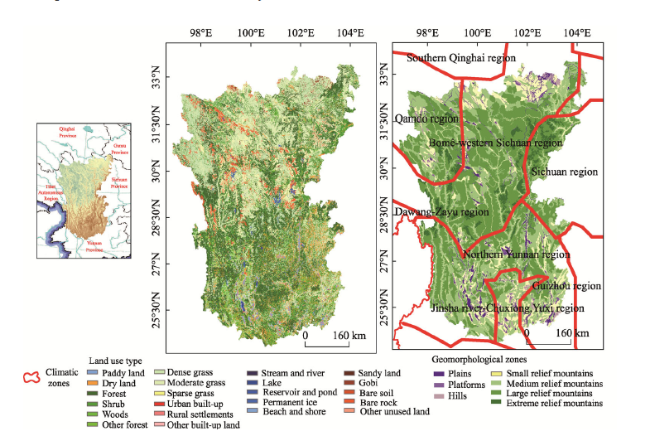
Figure 1 Location, land use type, geomorphology, and climate division of the Hengduan Mountain region |
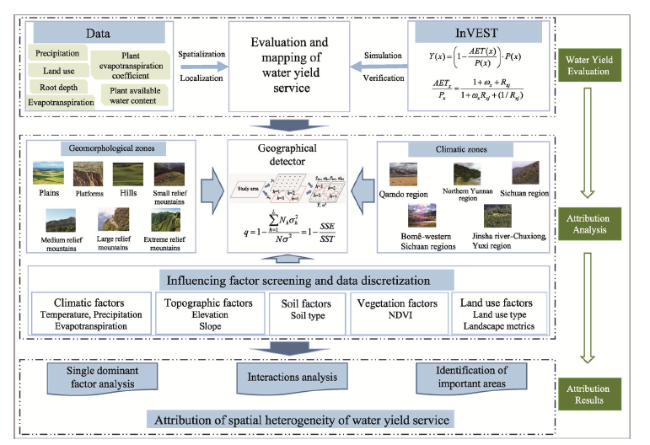
Figure 2 Framework for the spatial heterogeneity and driving mechanism of water yield service |
Table 1 Driving factors for water yield spatial heterogeneity in the Hengduan Mountain region |
| Category | Indicators | Data type | Category | Indicators | Data type |
|---|---|---|---|---|---|
| Climate | Annual average temperature | Continuous | Land use | Land use types | Discrete |
| Precipitation | Continuous | SHDI | Continuous | ||
| Solar radiation | Continuous | CONTAG | Continuous | ||
| Actual evapotranspiration | Continuous | MESH | Continuous | ||
| Topography | Elevation | Continuous | PLAND (cultivated land) | Continuous | |
| Slope | Continuous | PLAND (forests) | Continuous | ||
| Soil | Soil type | Discrete | PLAND (grassland) | Continuous | |
| Vegetation | NDVI | Continuous |
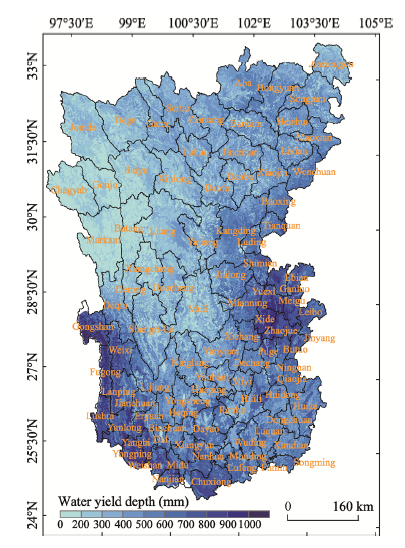
Figure 3 Spatial pattern of water yield service in the Hengduan Mountain region |
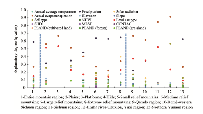
Figure 4 Influence of different driving factors on spatial heterogeneity of water yield in different climatic and geomorphological zones |
Table 2 The dominant interactions between two driving factors in different climatic and geomorphological zones in the Hengduan Mountain region |
| Regions | Dominant interactions |
|---|---|
| Entire mountain region | Precipitation∩actual evapotranspiration, precipitation∩land use type, precipitation∩soil type |
| Plains | Precipitation∩actual evapotranspiration, precipitation∩land use type, actual evapotranspiration∩soil type/elevation |
| Platforms | Precipitation∩actual evapotranspiration, precipitation∩land use type, actual evapotranspiration∩MESH metric |
| Hills | Precipitation∩actual evapotranspiration, actual evapotranspiration∩elevation, precipitation∩land use type |
| Small relief mountains | Precipitation∩actual evapotranspiration, precipitation∩land use type, precipitation∩soil type |
| Medium relief mountains | Precipitation∩actual evapotranspiration, precipitation∩land use type, precipitation∩soil type |
| Large relief mountains | Precipitation∩actual evapotranspiration, precipitation∩land use type, precipitation∩soil type |
| Extreme relief mountains | Precipitation∩actual evapotranspiration, precipitation∩land use type, precipitation∩PLAND(grassland) |
| Qamdo region | Precipitation∩actual evapotranspiration, actual evapotranspiration∩other factors |
| Bomê-western Sichuan region | Precipitation∩actual evapotranspiration, precipitation∩land use type, actual evapotranspiration∩other factors |
| Sichuan region | Precipitation∩actual evapotranspiration, actual evapotranspiration∩land use type |
| Jinsha river-Chuxiong, Yuxi region | Precipitation∩actual evapotranspiration, actual evapotranspiration∩land use type |
| Northern Yunnan region | Precipitation∩actual evapotranspiration, precipitation∩land use type, precipitation∩soil type |
Table 3 Water yield identification for important areas in different climatic and geomorphological zones in the Hengduan Mountain region |
| Regions | Elevation (m) | Slope (°) | Soil type | NDVI | Land use type |
|---|---|---|---|---|---|
| Entire mountain region | 1591-2484 | 25-35 | Primarosol | 0.78-0.94 | Shrub |
| Plains | 2069-2484 | 0.72-0.78 | Shrub | ||
| Platforms | 2069-2484 | Primarosol | 0.78-0.94 | Shrub | |
| Hills | 3377-3797 | Primarosol | 0.78-0.94 | Woods, shrub | |
| Small relief mountains | 2069-2484 | 25-35 | Primarosol | 0.78-0.94 | Shrub |
| Medium relief mountains | 2069-2484 | 25-35 | Primarosol | 0.78-0.94 | Shrub |
| Large relief mountains | 2069-2484 | Primarosol | 0.78-0.94 | Shrub | |
| Extreme relief mountains | 2924-3377 | 25-35 | 0.78-0.94 | Shrub | |
| Qamdo region | 3797-6808 | 0-5 | Primarosol | 0.78-0.94 | Shrub |
| Bomê-western Sichuan region | 347-1591 | 0-5 | Primarosol, anthropogenic soil | 0.78-0.94 | Shrub |
| Sichuan region | 347-1591 | 0-5 | Primarosol, anthropogenic soil | Shrub, other forests | |
| Jinsha river-Chuxiong, Yuxi region | 1591-2069 | 0-5 | Primarosol | 0.72-0.78 | Shrub |
| Northern Yunnan region | 3797-4548 | 25-35 | Primarosol | 0.78-0.94 | Sparse grass |
| [1] |
|
| [2] |
|
| [3] |
|
| [4] |
|
| [5] |
|
| [6] |
|
| [7] |
|
| [8] |
|
| [9] |
|
| [10] |
|
| [11] |
|
| [12] |
|
| [13] |
|
| [14] |
|
| [15] |
|
| [16] |
|
| [17] |
|
| [18] |
|
| [19] |
|
| [20] |
|
| [21] |
|
| [22] |
|
| [23] |
|
| [24] |
|
| [25] |
|
| [26] |
|
| [27] |
|
| [28] |
|
| [29] |
|
| [30] |
|
| [31] |
|
| [32] |
TEEB, 2013. The Economics of Ecosystems and Biodiversity for Water and Wetlands. IEEP, London and Brussels; Ramsar Secretariat Gland.
|
| [33] |
|
| [34] |
|
| [35] |
|
| [36] |
|
| [37] |
|
| [38] |
|
| [39] |
|
| [40] |
|
| [41] |
|
| [42] |
|
/
| 〈 |
|
〉 |