
Journal of Geographical Sciences >
Holocene hydro-environmental evolution and its impacts on human occupation in Jianghan-Dongting Basin, middle reaches of the Yangtze River, China
|
Zhao Chengshuangping (1991-), PhD Candidate, specialized in environmental evolution and geoarchae-ology. E-mail: zhaochengsp@pku.edu.cn |
Received date: 2019-10-27
Accepted date: 2019-12-10
Online published: 2020-05-25
Supported by
The Major Program of the National Social Science Foundation of China(No.11&ZD183)
Foundation for Distinguished Professors of Henan Province()
Zhengzhou Research Council for the Origins of Chinese Civilization()
National Key Project of Scientific and Technical Supporting Program of China(No.2013BAK08B02)
National Natural Science Foundation of China(No.41701220)
Copyright
Based on the comprehensive analyses of 18 core profiles’ sedimentary sequences and lithological characteristics in Jianghan-Dongting Basin of the middle reaches of the Yangtze River and the spatial-temporal distribution of archeological sites in this area, we reconstructed the Holocene hydro-environmental evolution, and its relationship with human occupation. The comparison reveals: 11.5-5.5 ka BP, the water level of rivers and lakes in the middle Yangtze River appeared a rising trend, concurrently, under the development of Neolithic culture and rice agricultural activities, human occupation extended from piedmont plain to inner basin plain in the study area. The water level fell in 5.5-4.0 ka BP, meanwhile, the number of human settlements of Qujialing-Shijiahe culture rapidly increased, especially in the inner basin plain. The water level rose again around 4.0 ka BP, floods spread massively in this period, which led to the decline of Shijiahe culture. The main causes for hydro-environmental evolution in the study area are the fluctuation of sea level and the aggradation of fluvio-lacustrine sediments.
ZHAO Chengshuangping , MO Duowen . Holocene hydro-environmental evolution and its impacts on human occupation in Jianghan-Dongting Basin, middle reaches of the Yangtze River, China[J]. Journal of Geographical Sciences, 2020 , 30(3) : 423 -438 . DOI: 10.1007/s11442-020-1735-6
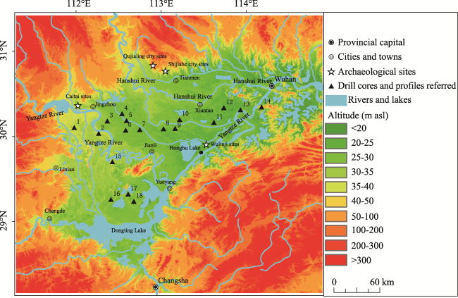
Figure 1 Location of Jianghan-Dongting Basin, middle reaches of the Yangtze River, China and drill cores1. Songzibabao188. 2. MHK02. 3. JZ-2010. 4. Zhangjinhai345. 5. 47. 6. QS01. 7. Xingou. 8. Zhoulao. 9. WS03. 10. M1. 11. DTH01. 12. Chunliangling454. 13. ZK76. 14. ZK84. 15. Wanzikou274. 16. CK37. 17. CK21. 18. ZK01. |
Figure 2 Geomorphologic map of Jianghan-Dongting Basin, middle reaches of the Yangtze River, China |
Table 1 The list of sediment cores |
| Number | Name | Location | References |
|---|---|---|---|
| 1 | Songzibabao188 | Babao town, Songzi city, Jingzhou city, Hubei province | Jin Boxin, 1992 |
| 2 | MHK02 | Mahaokou town, Gongan county, Hubei province | Chen and Wang, 2014 |
| 3 | JZ-2010 | Jiangbei farm, Jiangling district, Jingzhou city, Hubei province | Li F et al., 2014 |
| 4 | Zhangjinhai345 | Zhangjin town, Qianjiang city, Hubei province | Jin Boxin, 1992 |
| 5 | 47 | Liuheyuan farm, Jiangling district, Jingzhou city, Hubei province | Shi Zhixin, 1997 |
| 6 | QS01 | Qinshi town, Jiangling district, Jingzhou city, Hubei province | Chen and Wang, 2014 |
| 7 | Xingou | Xingou town, Jianli county, Hubei province | Wang and Li, 2009 |
| 8 | Zhoulao | Zhoulao town, Jianli county, Hubei province | Zhang Yufen et al., 2005 |
| 9 | WS03 | Yijiawan, Wangshi town, Jianli county, Hubei province | Chen and Wang, 2014 |
| 10 | M1 | Miancheng town, Xiantao city, Hubei province | Zhu Yuxin et al., 1997 |
| 11 | DTH01 | Datonghu farm, Honghu city, Hubei province | Chen and Wang, 2014 |
| 12 | Chunliang- ling454 | Chunliangling, Xiantao city, Hubei province | Jin Boxin, 1992 |
| 13 | ZK76 | Caidian district, Wuhan city, Hubei province | Chen and Wang, 2014 |
| 14 | ZK84 | Mentangwan, Jiangxia district, Wuhan city, Hubei province | Chen and Wang, 2014 |
| 15 | Wanzikou274 | Wanzikou, Shishou city, Jingzhou city, Hubei province | Jin Boxin, 1992 |
| 16 | CK37 | The western Dongting lake region, Hunan province | Zhang Xiaoyang et al., 1994 |
| 17 | CK21 | Zhuzikou town, Huarong county, Hunan province | Zhang Xiaoyang et al., 1994 |
| 18 | ZK01 | Zhuzikou town, Huarong county, Hunan province | Li Jun, 2009 |
Figure 3 Diagram illustrating the main Holocene sediment cores and profiles |
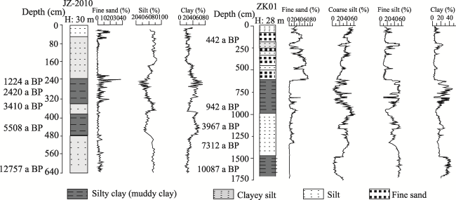
Figure 4 Grading curve of JZ-2010 (Li F et al., 2014) and ZK01 (Li Jun, 2009) |
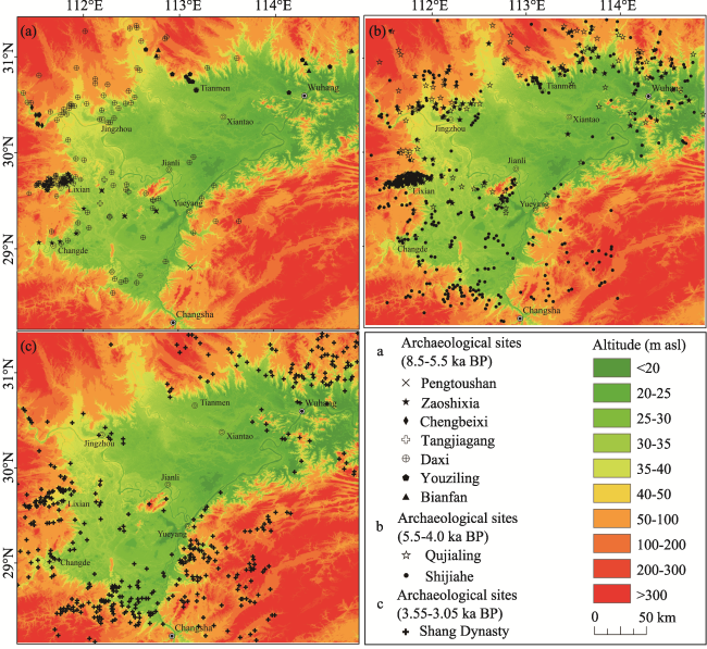
Figure 5 Settlement distribution during Holocene (adapted from Deng Hui, 2009) |
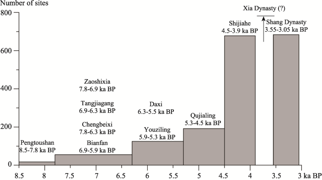
Figure 6 Histogram showing the number of sites in the middle reaches of the Yangtze River |
| [1] |
|
| [2] |
|
| [3] |
|
| [4] |
|
| [5] |
|
| [6] |
|
| [7] |
|
| [8] |
|
| [9] |
|
| [10] |
|
| [11] |
|
| [12] |
|
| [13] |
|
| [14] |
|
| [15] |
|
| [16] |
|
| [17] |
|
| [18] |
|
| [19] |
Hunan Institute of Cultural Relics and Archaeology (HICRA), 2006. Pengtoushan and Bashidang. Beijing: Science Press. (in Chinese)
|
| [20] |
Hunan Institute of Cultural Relics and Archaeology (HICRA), 2007. Chengtoushan in Lixian County. Beijing: Cultural Relics Press. (in Chinese)
|
| [21] |
|
| [22] |
|
| [23] |
|
| [24] |
|
| [25] |
|
| [26] |
|
| [27] |
|
| [28] |
|
| [29] |
|
| [30] |
|
| [31] |
|
| [32] |
|
| [33] |
|
| [34] |
|
| [35] |
Shijiahe Archaeology Team (SAT), 1992. An investigation report on Shijiahe sites. Southern Ethnology and Archaeology, ( 5):213-294. (in Chinese)
|
| [36] |
|
| [37] |
|
| [38] |
|
| [39] |
|
| [40] |
|
| [41] |
|
| [42] |
|
| [43] |
|
| [44] |
|
| [45] |
|
| [46] |
|
| [47] |
|
| [48] |
|
| [49] |
|
| [50] |
|
| [51] |
|
| [52] |
|
| [53] |
|
| [54] |
|
| [55] |
|
| [56] |
|
| [57] |
|
| [58] |
|
| [59] |
|
| [60] |
|
| [61] |
|
| [62] |
|
| [63] |
|
| [64] |
|
/
| 〈 |
|
〉 |

