

Journal of Geographical Sciences >
Traditional agroecosystem transition in mountainous area of Three Gorges Reservoir Area
|
Liang Xinyuan (1996-), Master, specialized in land use change and integrated physical geography. E-mail: liang_xiny @foxmail.com |
Received date: 2019-03-04
Accepted date: 2019-04-28
Online published: 2020-04-21
Supported by
Key Basic Science and Cutting Edge Technology Research Plan of Chongqing(No.cstc2015jcyjB0439)
Chongqing University Innovation Team for 2016(No.CXTDX201601017)
National Natural Science Foundation of China(No.41661020)
Chongqing Research Program of Basic Research and Frontier Technology(No.cstc2018jcyjAX0539)
Copyright
The Three Gorges Reservoir Area (TGRA) is typical of an ecologically vulnerable area, comprised of rural and mountainous areas, and with high immigration. Because of its economic and ecologic importance, studying the traditional agroecosystem changes in the TGRA is key to rural development and revitalization. In this study, we apply a framework of theoretical analysis, empirical study, and trend prediction to the Caotangxi River watershed within the TGRA. Using QuickBird high-resolution remote sensing images from 2012 to 2017 to evaluate natural resources and farmers’ behavior, we analyze the transition and trends in the traditional agroecosystem in mountainous areas of the TGRA at spatial scale of the man-land relationship. We find that the agroecosystem in the TGRA can be divided into four modes using 100 m interval buffer rings: high-low-low, high-low-high, low-high-low and low-low-high mode where the different modes represent the agricultural development stages in the TGRA. Furthermore, the traditional agroecosystem in TGRA, represented by system elements such as farmers and sloping farmland, is transforming to accommodate the diversification of farmer livelihoods. For example, sloping farmland, which was dominated by a production function, now has equal emphasis on ecological and economic functions. Spatially, the range of the agroecosystem transition has migrated beyond high mountain areas to flat valley areas. Generally, this study provides an overview of land use in rural areas, controls on soil and water loss in mountainous areas, and better rural living environments in the TGRA.
LIANG Xinyuan , LI Yangbing , SHAO Jing’an , RAN Caihong . Traditional agroecosystem transition in mountainous area of Three Gorges Reservoir Area[J]. Journal of Geographical Sciences, 2020 , 30(2) : 281 -296 . DOI: 10.1007/s11442-020-1728-5
Figure 1 The evolution theoretical model of the mountain agroecosystem |
Figure 2 Agroecosystem transition in the Three Gorges Reservoir Area (photographs from August 2017) |
Figure 3 Location of the study area in the mountainous hinterland of the Three Gorges Reservoir Area |
Table 1 Reference standards for different settlement attributes |
| Settlement type | Identification standard | Sources | Interpretation reference |
|---|---|---|---|
| Decline | Signs of cultivation near settlements are disappearing and abandoned land trends are clear; the landscape tends to be monotonous; the colors of residential locations are dim; and surrounding roads are gradually replaced by “forest-shrub-grass”. | CNES Astrium Quick Bird (0.51 m) |  |
| Stagnation | The distribution of the surrounding farmland is scattered and there are no signs of consolidation; the overall landscape pattern is balanced; the colors of residential locations are generally dark; and infrastructure construction is declining. |  | |
| Development | The surrounding farmland shows order and there are signs of consolidation; a weak fruit forest planting trend appears; the ecological landscape tends to be diverse; the colors of the residential locations are white; and individual homes are clear. |  | |
| Vigor | Clearly fruit forest planting trend near the settlements; the surrounding infrastructure is complete; the landscape is diverse; the colors of residential locations are bright; and the stereo perception of the settlements is strong. |  |
Figure 4 Framework to classify farmer livelihoods |
Table 2 Classification of land use degree |
| Land grade | Unused | Natural | Agricultural | Construction |
|---|---|---|---|---|
| Land use type | Unused land | Forest land, grass land, water and abandoned farmland | Sloping farmland, orchard and economic fruit forest | Urban land, rural residential land, industrial and mining land and transport land |
| Graded index | 1 | 2 | 3 | 4 |
Figure 5 Classification criteria of agroecosystem modes |
Figure 6 Selection of the landscape transect |
Figure 7 Examples of different agroecosystem modes |
Table 3 Typical landscape characteristics of the agroecosystem |
| Economic fruit forest | Abandoned farmland | Sloping farmland | Forest-shrub-grass land | |
|---|---|---|---|---|
| HLL | 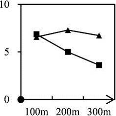 | 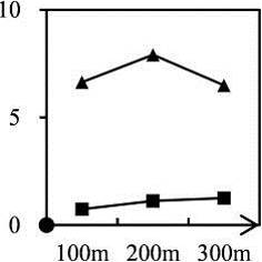 | 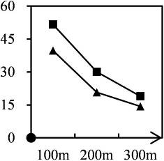 | 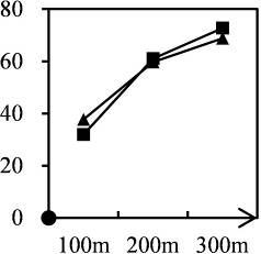 |
| HLH | 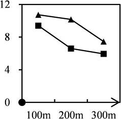 | 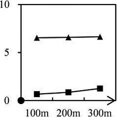 | 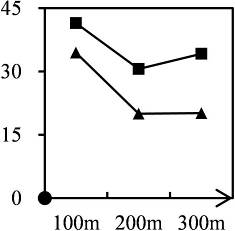 | 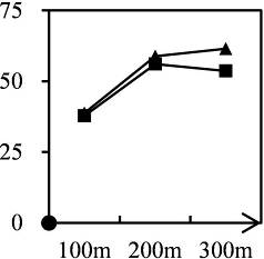 |
| LHL | 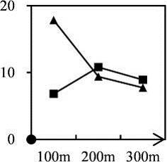 | 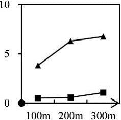 | 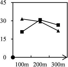 | 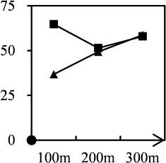 |
| LLH | 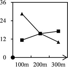 | 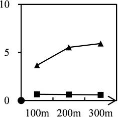 | 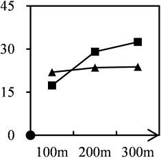 | 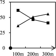 |
 | ||||
Note: Y-axis represents the proportion of typical landscape, and X-axis represents the buffer ring with different distances. |
Figure 8 The landscape characterization of the agroecosystem transition |
Figure 9 The changing relationships between system elements during the agroecosystem transition |
Figure 10 The changing modes of the agroecosystem transition from 2012 to 2017 in the Three Gorges Reservoir Area |
Figure 11 Trends in the agroecosystem transition |
| [1] |
|
| [2] |
|
| [3] |
|
| [4] |
|
| [5] |
|
| [6] |
|
| [7] |
|
| [8] |
|
| [9] |
|
| [10] |
|
| [11] |
|
| [12] |
|
| [13] |
|
| [14] |
|
| [15] |
|
| [16] |
|
| [17] |
|
| [18] |
|
| [19] |
|
| [20] |
|
| [21] |
|
| [22] |
|
| [23] |
|
| [24] |
|
| [25] |
|
| [26] |
|
| [27] |
|
| [28] |
|
| [29] |
|
| [30] |
|
/
| 〈 |
|
〉 |