
Journal of Geographical Sciences >
Compilation of 1:50,000 vegetation type map with remote sensing images based on mountain altitudinal belts of Taibai Mountain in the North-South transitional zone of China
|
Yao Yonghui (1975-), PhD and Associate Professor, specialized in GIS/RS application and mountain environment. E-mail: yaoyh@lreis.ac.cn |
Received date: 2019-04-17
Accepted date: 2019-06-20
Online published: 2020-04-21
Supported by
National Natural Science Foundation of China(No.41871350)
National Natural Science Foundation of China(No.41571099)
Scientific and Technological Basic Resources Survey Project(No.2017FY100900)
Copyright
The compilation of 1:250,000 vegetation type map in the North-South transitional zone and 1:50,000 vegetation type maps in typical mountainous areas is one of the main tasks of Integrated Scientific Investigation of the North-South Transitional Zone of China. In the past, vegetation type maps were compiled by a large number of ground field surveys. Although the field survey method is accurate, it is not only time-consuming, but also only covers a small area due to the limitations of physical environment conditions. Remote sensing data can make up for the limitation of field survey because of its full coverage. However, there are still some difficulties and bottlenecks in the extraction of remote sensing information of vegetation types, especially in the automatic extraction. As an example of the compilation of 1:50,000 vegetation type map, this paper explores and studies the remote sensing extraction and mapping methods of vegetation type with medium and large scales based on mountain altitudinal belts of Taibai Mountain, using multi-temporal high resolution remote sensing data, ground survey data, previous vegetation type map and forest survey data. The results show that: 1) mountain altitudinal belts can effectively support remote sensing classification and mapping of 1:50,000 vegetation type map in mountain areas. Terrain constraint factors with mountain altitudinal belt information can be generated by mountain altitudinal belts and 1:10,000 Digital Surface Model (DSM) data of Taibai Mountain. Combining the terrain constraint factors with multi-temporal and high-resolution remote sensing data, ground survey data and previous small-scale vegetation type map data, the vegetation types at all levels can be extracted effectively. 2) The basic remote sensing interpretation and mapping process for typical mountains is interpretation of vegetation type-groups→interpretation of vegetation formation groups, formations and subformations→interpretation and classification of vegetation types & subtypes, which is a combination method of top-down method and bottom-up method, not the top-down or the bottom-up classification according to the level of mapping units. The results of this study provide a demonstration and scientific basis for the compilation of large and medium scale vegetation type maps.
YAO Yonghui , SUONAN Dongzhu , ZHANG Junyao . Compilation of 1:50,000 vegetation type map with remote sensing images based on mountain altitudinal belts of Taibai Mountain in the North-South transitional zone of China[J]. Journal of Geographical Sciences, 2020 , 30(2) : 267 -280 . DOI: 10.1007/s11442-020-1727-6
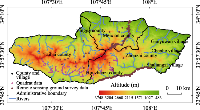
Figure 1 Outline of Taibai Mountain and the distribution of ground survey samples |
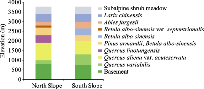
Figure 2 Mountain altitudinal belts of Taibai Mountain (after Fang and Gao, 1963; Li, 2007) |
Table 1 Remote sensing images of Taibai Mountain |
| Sensor | Time | Resolution | Sensor | Time | Resolution |
|---|---|---|---|---|---|
| GF2 | August 3, 2017 | 0.8 m | ZY3 | September 28, 2017 | 2 m |
| September 7, 2017 | 0.8 m | August 5, 2017 | 2 m | ||
| September 7, 2017 | 0.8 m | August 31, 2016 | 2 m | ||
| August 3, 2017 | 0.8 m | February 3, 2018 | 2 m | ||
| GF1 | August 28, 2016 | 2 m | February 8, 2018 | 2 m | |
| November 30, 2016 | 2 m | September 28, 2017 | 2 m | ||
| October 28, 2017 | 2 m | August 5, 2017 | 2 m | ||
| February 12, 2017 | 2 m | August 31, 2016 | 2 m | ||
| August 28, 2016 | 2 m | February 3, 2018 | 2 m | ||
| November 30, 2016 | 2 m | February 8, 2018 | 2 m | ||
| October 28, 2017 | 2 m | July 14, 2017 | 2 m | ||
| February 12, 2017 | 2 m | September 22, 2016 | 2 m | ||
| August 8, 2017 | 16 m | September 22, 2016 | 2 m | ||
| January 20, 2015 | 16 m | November 10, 2016 | 2 m | ||
| October 1, 2015 | 16 m | November 4, 2017 | 2 m | ||
| July 1, 2017 | 16 m | January 13, 2017 | 2 m | ||
| February 12, 2017 | 16 m | July 14, 2017 | 2 m | ||
| ZY3 | November 4, 2017 | 2 m | September 22, 2016 | 2 m | |
| January 13, 2017 | 2 m | November 10, 2016 | 2 m |
Table 2 Vegetation classification system of Taibai Mountain |
| Vegetation type groups | Vegetation types, sub-types | Vegetation formation groups, formations, sub-formation |
|---|---|---|
| Meadows | Kobresia, forbs alpine meadows | Polygonum macrophyllum D. D, Polygonum viviparum meadow |
| Temperate grasses, forbs meadows | Carex lanceolata, grasses meadow | |
| Carex lanceolata, forbs meadow | ||
| Shrubs | Subalpine deciduous broad-leaved shrubs | Salix cupularis shrub |
| Spiraea mongolica shrub | ||
| Subalpine evergreen leather-leaved shrubs | Rhododendron lapponicum shrub | |
| Rhododendron clementinae subsp. Aureodorsale shrub | ||
| Rhododendron purdomii shrub | ||
| Rhododendron capitatum shrub | ||
| Coniferous forests | Temperate coniferous forests | Platycladus orientalis forest |
| Pinus tabuliformis forest | ||
| Subtropical and tropical montane coniferous forests | Abies fargesii, Larix chinensis forest | |
| Abies fargesii forest | ||
| Larix chinensis forest | ||
| Subtropical coniferous forests | Pinus armandii, Larix chinensis forest | |
| Pinus armandii forest | ||
| Mixed forests | Temperate coniferous and deciduous broad-leaved mixed forests | Platycladus orientalis, Quercus aliena var. acuteserrata forest |
| Platycladus orientalis, Quercus variabilis forest | ||
| Pinus tabuliformis, Quercus serrata var. brevipetiolata forest | ||
| Pinus tabuliformis, Quercus aliena var. acuteserrata forest | ||
| Pinus tabuliformis, quercus variabilis forest | ||
| Subtropical montane coniferous and deciduous broad-leaved mixed forests | Abies fargesii, Betula albo-sinensis forest | |
| Abies fargesii, Betula albo-sinensis var. septentrionalis forest | ||
| Pinus armandii, Quercus spinosa forest | ||
| Pinus armandii, Quercus serrata var. brevipetiolata forest | ||
| Pinus armandii, Betula albo-sinensis forest | ||
| Pinus armandii, Quercus baronii forest | ||
| Pinus armandii, Quercus liaotungensis forest | ||
| Pinus armandii, Betula albo-sinensis var. septentrionalis forest | ||
| Pinus armandii, Quercus aliena var. acuteserrata forest | ||
| Pinus armandii, Fagus longipetiolata forest | ||
| Pinus armandii, Populus davidiana forest | ||
| Pinus armandii, Quercus variabilis forest | ||
| Broadleaf forests | Temperate deciduous broad-leaved forests | Betula albo-sinensis, Quercus liaotungensis forest |
| Betula albo-sinensis forest | ||
| Quercus baronii forest | ||
| Quercus liaotungensis forest | ||
| Vegetation type groups | Vegetation types, sub-types | Vegetation formation groups, formations, sub-formation |
| Betula albo-sinensis var. septentrionalis forest | ||
| Quercus aliena var. acuteserrata, Pterocarya stenoptera forest | ||
| Quercus aliena var. acuteserrata, Quercus acutissima forest | ||
| Quercus aliena var. acuteserrata, Populus davidiana forest | ||
| Quercus aliena var. acuteserrata forest | ||
| Populus davidiana, Quercus liaotungensis forest | ||
| Populus davidiana forest | ||
| Quercus variabilis, Quercus aliena var. acuteserrata forest | ||
| Quercus variabilis, Populus simonii forest | ||
| Quercus variabilis, Ulmus pumila forest | ||
| Quercus variabilis forest | ||
| Cultivated plants | Dry farming of three matures in two years or double cropping in one year | Triticum aestivum, Zea mays Linn. Sorghum bicolor (L.) Moench |
| Deciduous orchard | Castanea mollissima BL., Juglans regia L. |
Figure 3 Terrain constraint factor map with mountain altitudinal belts information |
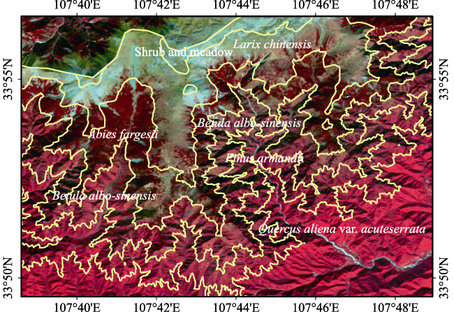
Figure 4 Terrain constraint factor map overlaying with remote sensing images (South slope, Time: 2017/02/12; Resolution: 2 m; Band combination: 432 pseudo-color) |
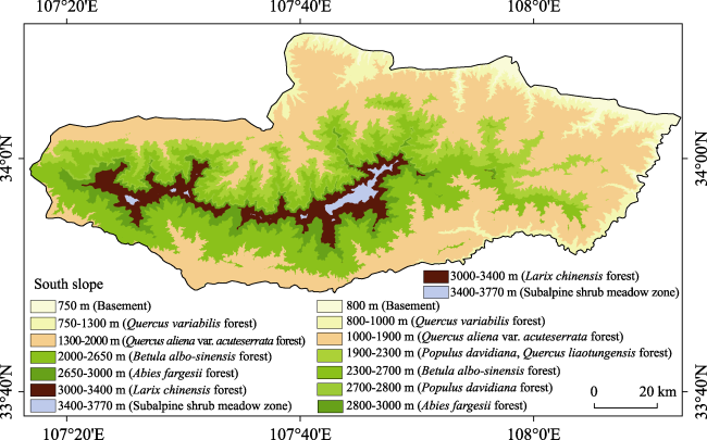
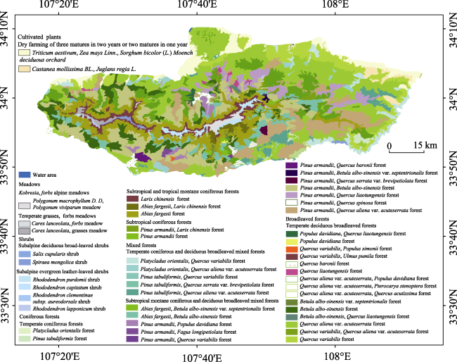
Figure 5 Vegetation type map of Taibai Mountain |
| [1] |
|
| [2] |
Chinese Vegetation Map Editorial Committee (CVMEC), Chinese Academy of Sciences, 2000. Atlas of 1:1000000 Chinese Vegetation. Beijing: Science Press. (in Chinese)
|
| [3] |
Chinese Vegetation Map Editorial Committee (CVMEC), Chinese Academy of Sciences, 2007. Vegetation and Its Geographical Patterns in China: Instructions for Vegetation Maps of the People’s Republic of China. Beijing: Geology Press. (in Chinese)
|
| [4] |
|
| [5] |
|
| [6] |
|
| [7] |
|
| [8] |
|
| [9] |
|
| [10] |
|
| [11] |
|
| [12] |
|
| [13] |
|
| [14] |
|
| [15] |
|
| [16] |
|
| [17] |
|
| [18] |
|
| [19] |
|
| [20] |
|
| [21] |
|
| [22] |
|
| [23] |
|
| [24] |
|
| [25] |
|
| [26] |
|
/
| 〈 |
|
〉 |