Research Articles

Evolution and driving forces of rural functions in urban agglomeration: A case study of the Chang-Zhu-Tan region

  • TAN Xuelan 1, 2 ,
  • OUYANG Qiaoling 1 ,
  • AN Yue 1 ,
  • MI Shengyuan 1 ,
  • JIANG Lingxiao 1 ,
  • ZHOU Guohua , 2, *
Expand
  • 1. College of Resources and Environment, Hunan Agricultural University, Changsha 410128, China
  • 2. Department of Resources and Environment Science, Hunan Normal University, Changsha 410081, China
*Zhou Guohua (1965-), Professor, E-mail:

Tan Xuelan (1978-), PhD and Associate Professor, specialized in rural geography and regional development. E-mail: txl780120@163.com

Received date: 2018-09-05

  Accepted date: 2018-11-28

  Online published: 2019-12-13

Supported by

National Natural Science Foundation of China(No.41571168)

Key Project of Philosophy and Social Science Foundation of Hunan Province(No.18ZDB015)

Copyright

Copyright reserved © 2019. Office of Journal of Geographical Sciences All articles published represent the opinions of the authors, and do not reflect the official policy of the Chinese Medical Association or the Editorial Board, unless this is clearly specified.

Abstract

As the Rural Revitalization Strategy is gradually implemented, China’s rural areas are set to have more diverse function requirements. This paper selects the Changsha-Zhuzhou-Xiangtan region (Chang-Zhu-Tan) consisting of 23 county-level units) as a case study and looks at its economic development, agricultural product supply, social security and ecological service functions during 1996-2016. It then constructs an index system to evaluate the temporal evolution of the region’s rural functions. SPSS 19.0 and DPS 7.05 software, as well as Pearson’s correlation coefficient analysis, system clustering, optimal segmentation of ordered samples and other methods, are used to study the evolution traits, regional differentiation characteristics and driving forces of rural functions in the region. The results show, first of all, that the overall evolution trend is increasing in functions with periodic characteristics, the key nodes being 2000 and 2008. Second, there is clear geographical differentiation in the evolution of rural functions. The economic development function shows rapid growth in the urban agglomeration’s center and relatively weak growth at the periphery; the agricultural product supply function and ecological service function are concentrated in county-level units with abundant cultivated and forest land; and the social security function displays similar geographical differentiation to the economic development function. Overall, there is an obvious discrepancy in the degree of development of rural functions among county-level units of the Changsha-Zhuzhou-Xiangtan urban agglomeration; the rural functions of the agglomeration and peripheral county-level units have different development traits; and county-level units display functional differentiation. Third, rural functions have evolved as a result of interactions between various factors, such as natural resources, socio-economic conditions and local transport conditions. The new driving forces caused by urbanization are ultimately leading the evolution of rural functions toward multi-functional comprehensive development.

Cite this article

TAN Xuelan , OUYANG Qiaoling , AN Yue , MI Shengyuan , JIANG Lingxiao , ZHOU Guohua . Evolution and driving forces of rural functions in urban agglomeration: A case study of the Chang-Zhu-Tan region[J]. Journal of Geographical Sciences, 2019 , 29(8) : 1381 -1395 . DOI: 10.1007/s11442-019-1665-3

1 Introduction

The coordinated development of rural areas has become an important topic of geographical research. The Chinese government’s Targeted Poverty Alleviation Project and Rural Revitalization Strategy focus on rural areas and highlight the value of rural functions. They provide scientific bases for guiding rural development, with a view to encouraging unified and integrated development between urban and rural areas. As rapid socio-economic development and gradual urbanization have occurred in China, realities such as population flows from rural to urban areas, the reorganization and interaction of urban and rural social and economic factors, changes in interactions between urban and rural areas, and diversification of conflicts between urban and rural areas have had a tremendous influence and impact on rural functions, creating an urgent need to carry out research in this area (Chen et al., 2008; Liu and Liu, 2012; Long, 2012; Long and Zhang, 2012; Fang and Liu, 2015; Tan et al., 2017; Tang et al., 2018; Zhang et al., 2018).
Scholars from China and abroad have conducted a number of studies on rural functions. Many of these studies are by Polish scholars who have evaluated and zoned rural functions (Stola, 1984). Scholars from other developed countries in Europe as well as from Japan, the US and Australia have carried out research on rural functions, with most focusing on the interplay of agricultural, ecological landscape, social and other functions in rural areas (Holmes, 2006; Hamblin, 2009; Holmes, 2012; Todorova and Ikova, 2014; Ondetti, 2016; McCann et al., 2017).
Research on rural functions by Chinese scholars began slightly later, but it has progressed quickly. With the launch of the Rural Revitalization Strategy, rural functions have become a hot topic of rural research in China, particularly the concepts and connotations of rural functions, function classification, function evaluation and zoning, and influencing factors (Zhen et al., 2010; Liu et al., 2011; Liu et al., 2012; Liu et al., 2013; Hong et al., 2016; Tan et al., 2017). Li Zhi, for example, conducted a study on the hierarchical evaluation and spatial differentiation of rural functions at the village scale (Li et al., 2017). Li Pingxing used quantitative evaluation methods to study spatial differences and influencing factors of rural functions (Li et al., 2014). Tan Xuelan, meanwhile, conducted a study that evaluated and identified features of regional differentiation of rural functions (Tan et al., 2018).
Looking at existing research perspectives, most studies focus on static research, that is, they focus on evaluating and analyzing regional differences in rural functions at a certain point in time, with many dwelling on the static principles of spatial differentiation of rural functions, whereas few studies look at the characteristics and principles of the evolution of rural functions at different time sequences, and there is a particular lack of studies that look in-depth at the mechanisms driving the evolution of rural functions. In terms of research methods, many studies adopt a single-method approach, and few use a combination of quantitative methods. Looking at the scale of studies, most are at the macro scale, such as at the national or regional scale, or at the micro scale, such as villages, with few studies looking at the meso scale of counties within urban agglomerations.
Rural functions display clear variation and spatial differentiation characteristics in the process of rural transformation and reconstruction. Studying the spatial and temporal evolution, stage-based features and regional differentiation of rural functions in the new era have become breakthrough areas of research on rural functions. As such, this study attempts to create a comprehensive index system for evaluating rural functions and then looks at the sequential evolution of rural functions of county-level units in the Changsha-Zhuzhou-Xiangtan region over two decades. It then considers the principles governing changes to, as well as the evolution mechanisms of, rural functions to provide a theoretical basis for the optimization and regional division of labor of rural functions and to enrich and improve the body of knowledge on rural functions.

2 Overview of study area

The Changsha-Zhuzhou-Xiangtan urban agglomeration is located in central China, and belongs to the central and eastern parts of Hunan Province close to Jiangxi Province. The terrain is hilly, and it is surrounded by mountains on three sides. The Xiangjiang River flows through the agglomeration, and Dongting Plain lies to the north. It consists of the three main cities of Changsha, Zhuzhou and Xiangtan and contains 23 counties (as well as county-level cities and municipal districts, hereinafter “county-level units”), with a land area of 28,000 km2, accounting for 13.34% of Hunan’s total land area. The agglomeration’s population was 14.49 million people in 2016, or 21% of the province’s total population, and with a rural population of 4.6 million. The agglomeration’s gross output is 40% of Hunan’s total, while the output value of the agriculture, forestry, livestock and fishery industries account for 18.5% of the province’s total. The Changsha-Zhuzhou-Xiangtan urban agglomeration has clear location advantages. It is a transition zone between China’s eastern coastal region and the central and western hinterland, and it is a crossover region of the Yangtze River Open Economic Belt and the Coastal Open Economic Belt. Interregional resource complementarity and economic cooperation have provided the conditions for development of the agglomeration’s three core cities, resulting in continuous overall improvement in urban and rural economies and a new stage of rapid transformation and reconstruction of rural and agricultural development. Influenced by the development of the urban agglomeration and based on its own conditions, Changsha’s rural infrastructure investment has increased significantly, Xiangtan’s manufacturing industry has become its dominant industry, while its rural economy has weakened, and agritourism has thrived in Zhuzhou’s rural areas, displaying the clear traits of diversification and differentiation of rural functions. Taking Changsha, Zhuzhou and Xiangtan as a typical case study of rural functions in urban agglomerations, this paper studies the evolution characteristics and developmental differences of rural areas in urban agglomerations and analyzes the typical and representative mechanisms driving their evolution.

3 Research method and data sources

3.1 Data sources

The 23 county-level units of the Changsha-Zhuzhou-Xiangtan urban agglomeration were selected as the study area. With consideration given to how representative and available data is for the study area, this study used panel data, including rural socio-economic statistical data, population statistical data and land use data, from the period 1996 to 2016 for each county-level unit in the urban agglomeration. Data was mainly sourced from the Hunan Statistical Yearbook, Hunan Rural Statistical Yearbook and the Annual Social and Economic Bulletins of County-level Administrative Areas from 1997 to 2017. As data for the core cities of Changsha, Zhuzhou and Xiangtan is given for the entire urban areas and not divided into districts, the missing data for municipal districts has been supplemented using linear interpolation.

3.2 Constructing the evaluation index system

This study constructed an index system for evaluating rural functions using four subsystems: economic development function, agricultural product supply function, social security function and ecological service function. The indicators (22 in total, see Table 1) were selected to reflect the rural nature of the region, with a focus on the overall status of rural functions of county-level units. The indicators of gross regional product; output value of agriculture, forestry, livestock and fisheries; fiscal revenue; industrial structure and rural employment structure were used to characterize the rural economic development function. Given that the agricultural product supply function is the main function of rural areas, indicators including the coefficient of cultivated land, quality of cultivated land, area of land planted with crops, and per capita grain, meat and subsidiary agricultural product consumption were used. The social security function is reflected in production, living, employment and healthcare conditions, so indicators such as per capita net income, level of urbanization, Engel’s coefficient, power facilities and health service levels were used. The ecological service function cannot afford to be overlooked in rural areas, but due to the difficulty of obtaining relevant data, this study uses indicators such as area of afforestation, area of land subject to water and soil conservation measures, area of land affected by natural disasters and fertilizer intensity to represent it.
Table 1 Index systems for measuring rural functions of the Changsha-Zhuzhou-Xiangtan urban agglomeration
Subsystem Indicator Weight Indicator attribute Data source
Economic development function Gross regional product 0.336 GRP/total area
Average fiscal contribution 0.346 Regional fiscal revenue/total area
Industrial structure 0.018 Output value of secondary and tertiary industries/GRP
Agricultural employment structure 0.028 Non-agricultural rural labor force/total rural labor force
Number of agricultural workers 0.181 Rural statistical yearbook
Per capita output value of agriculture, forestry, livestock and fisheries 0.091 Output value of agriculture, forestry, livestock and fisheries/total population
Agricultural product supply function Quality of cultivated land 0.271 Effective irrigated area/area of cultivated land
Coefficient of cultivated land 0.106 Area of cultivated land/total area
Area of crop land 0.253 Rural statistical yearbook
Per capita grain consumption 0.140 Total grain output/total population
Per capita meat consumption 0.115 Total meat output/total population
Per capita fresh subsidiary agricultural product consumption 0.115 Total output of fresh fruit and vegetables/total population
Social security function Income level 0.068 Per capita net income of rural residents
Social consumption level 0.309 Total retail sales of consumer goods/total population
Urbanization level 0.189 Non-rural population/total population
Engel’s coefficient 0.088 Food expenditure/total living expenses
Rural power facilities 0.056 Rural electricity consumption/rural population
Health service level 0.290 Number of beds in healthcare institutions per 10,000 people
Ecological service function Afforestation area 0.410 Rural statistical yearbook
Area of water and soil conservation 0.494 Rural statistical yearbook
Area affected by natural disasters 0.047 Rural statistical yearbook
Fertilizer intensity 0.049 Volume of fertilizer applied/area of cultivated land

3.3 Research method

3.3.1 Function index evaluations
The linear weighted sum method was used to synthesize the 22 evaluation indicators in order to calculate the rural function index for each year, which will reflect the evolution characteristics and differences in rural functions of the Changsha-Zhuzhou-Xiangtan urban agglomeration as a whole as well as its constituent county-level units. To eliminate dimensional influence between indicators and ensure their comparability, the extreme value method was used to standardize the data for each indicator, as follows:
Positive indicators:
${{X}_{ij}}=\frac{{{X}_{n}}-{{X}_{\min }}}{{{X}_{\max }}-{{X}_{\min }}}$
Negative indicators:
${{X}_{ij}}=\frac{{{X}_{\max }}-{{X}_{n}}}{{{X}_{\max }}-{{X}_{\min }}}$
where Xij is the normalized value (dimensionless) of indicator i for geographical unit j; Xn is the original value of indicator n; Xmax is the maximum value of indicator n; and Xmin is the minimum value of that indicator. Having used the entropy method to determine the weight Wj of each indicator, the economic development function index (EDFi), agricultural product supply function index (APFi), social security function index (SSFi) and ecological service function index (ESFi) were calculated for each county-level unit in turn:
$EDFi=\sum{Xij*Wj}$S
where EDFi is the economic development function index of geographical unit i, Xij is the standardized value of the indicators, and Wj is the weight of the corresponding indicators. The larger the value of EDFi, the stronger the economic development function is for that location, and the lower the value, then the weaker the function. The calculation methods for the agricultural product supply, social security and ecological service functions are the same as for EDFi.
3.3.2 Optimal segmentation of ordered samples
With the function scores for each county-level administrative unit used as the original data matrix X, optimal segmentation of ordered samples was conducted using DPS software to cluster the development time sequences of each rural function into several time periods. First, the data variation matrix D was calculated, with the variation of the entire data matrix as follows:
${{d}_{ij}}=\sum\nolimits_{b=i}^{j}{\sum\nolimits_{a=1}^{p}{{{(zab-za(ij))}^{2}}}}$
where dij is the squared deviation and variation of each sample. The entire variation matrix D can be obtained by calculating n(n-1)/2 dij. The error function of each function time sequence matrix can be calculated as follows:
$\Psi [p(k,n)]=\sum\nolimits_{j=1}^{k}{(Dij,ij+1-1)}$
3.3.3 Spatial and temporal differentiation diagnosis model
By constructing a vertical comparison coefficient model for evaluating the rural functions of county-level units, long-term variations in rural functions were diagnosed by showing the index changes in rural functions from the base year to the end year. Taking the economic development function of the Changsha-Zhuzhou-Xiangtan region as an example to illustrate spatial and temporal differences in changes, the diagnostic model is as follows:
$VED{{F}_{i}}={EDFi2016}/{EDFi1996}\;$
where VEDFi is the vertical comparison coefficient model of the economic development function for region i, which is obtained by dividing the economic development function index of the end year by the base year. If the VEDFi value is lower than one, it means the economic development function of region i has increased during a certain time period, and if it is higher than one, it has decreased. The vertical comparison coefficients of the other functions are calculated the same way and are expressed as VAPFi, VSSFi and VESFi.

4 Analysis of results

4.1 Trends of rural function evolution in the Changsha-Zhuzhou-Xiangtan region

Pearson’s correlation coefficient of the annual rural function indexes and changes over time for the 23 county-level units of the Changsha-Zhuzhou-Xiangtan urban agglomeration for the period 1996-2016 was used to calculate the evolution trends of each rural function for the whole region. The results were 0.505 for the economic development function, -0.169 for the agricultural product supply function, -0.211 for the social security function and 0.564 for the ecological service function (Figure 1).
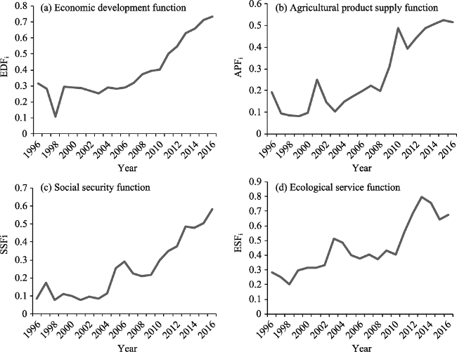
Figure 1 Rural function trends in the Changsha-Zhuzhou-Xiangtan urban agglomeration, 1996-2016
The agricultural product supply and social security functions had slight negative correlations. Although the overall values for indicators including the production of agricultural products and rural social security increased, the increases lagged behind increases in population, which meant that per capita agricultural product output and per capita public service levels actually decreased slightly in certain years.
The growth in the rural economic development function benefited from rapid socio- economic development, with rural areas of the region being strongly influenced by the radial effects and strong momentum of the core cities’ economic development, making rural areas strong reserve forces and important growth points of economic development.
Fluctuations in the evolution of the ecological service function reflect the game between the function and economic development. In recent years, increases in the ecological service function are proof of President Xi Jinping’s assertion, “Lucid waters and lush mountains are as valuable as gold and silver”. By implementing the “river chief” system, strengthening soil erosion control, encouraging rural eco-tourism, developing beautiful villages and other measures, government departments have enabled rural areas to make better use of their inherent ecological service function. Overall, the various rural functions of the Changsha-Zhuzhou-Xiangtan region have been on an upward trend over the past two decades, with an increase in the total number of rural functions.

4.2 Stage-based characteristics of rural function evolution in the Changsha-Zhuzhou- Xiangtan region

By plotting the development of rural functions for the 23 county-level administrative units in the Changsha-Zhuzhou-Xiangtan urban agglomeration between 1996 and 2016, it was possible to see the time sequence differences in the overall evolution of the functions. Using the optimal segmentation method in the DPS 7.05 software, each function of rural areas in the Changsha-Zhuzhou-Xiangtan region was clustered into several development stages. The results are shown in Table 2.
Table 2 Time cluster analysis of the rural functions of the Changsha-Zhuzhou-Xiangtan urban agglomeration, 1996-2016
Error function Time intervals
Economic development function 0.288 1996-1999, 2000-2007, 2008-2016
Agricultural product supply function 0.637 1996-2001, 2002-2007, 2008-2016
Social security function 0.152 1996-2004, 2005-2007, 2008-2016
Ecological service function 0.272 1996-2001, 2002-2008, 2009-2016
The time sequence for the economic development function was divided into three periods (1996-1999, 2000-2007 and 2008-2016) based on an optimal segmentation error function of 0.288, with the key nodes being 2000 and 2008. Since 2000, China has entered an urbanization transition period, and the Changsha-Zhuzhou-Xiangtan urban agglomeration has entered a period of integration, in which rural areas have been driven on by urban areas, the number and scale of rural industries has increased, and increased gross output and fiscal
revenue have enabled rapid development of the rural economic development function. In 2008, the Changsha-Zhuzhou-Xiangtan urban agglomeration was designated by the government as a key urban agglomeration for encouraging the development of China’s central region. Since then, its urban economy has developed rapidly, while rural areas have been swept along by the development of urban areas, resulting in continuous improvement in rural economic output.
Changes in the agricultural product supply function were divided into three periods (1996-2001, 2002-2007 and 2008-2016) based on an error function of 0.637, with the key nodes being 2002 and 2008. In the period 2002-2007, the agricultural product supply function decreased by an average of 0.0127 compared to the previous period. The main reasons are industrial transformation and a fall in per capita agricultural product consumption. The main plan for the Changsha-Zhuzhou-Xiangtan urban agglomeration in Hunan Province’s development strategy has been to develop manufacturing and tertiary industries. Agricultural production functions have mainly been shifted to regions with optimal agricultural conditions such as Dongting Lake. More and more rural areas are thus being hollowed out as the area of land given over to cultivation and utilization rates gradually decreases and the agricultural labor force shrinks. The number of agricultural products for which the Changsha-Zhuzhou-Xiangtan urban agglomeration is self-sufficient has decreased. The poor condition of irrigation facilities and the frequent occurrence of natural disasters such as floods and droughts are taking their toll on agricultural production.
Changes in the social security function were divided into three periods (1996-2004, 2005-2007 and 2008-2016) based on an error function of 0.152, with the key nodes being 2005 and 2008. By effectively integrating such factors of production as land, labor, new forms of agriculture and online sales, the Changsha-Zhuzhou-Xiangtan urban agglomeration has continuously expanded its rural industry chain. Since 2008, the region’s ratio of urban to rural income has narrowed from 2.36:1 to 2.22:1. The construction of the Changsha-Zhuzhou-Xiangtan trunk road and inter-city railway as well as other public facilities and employment and medical facilities raised living standards and employment levels of the rural population in the region, especially in the third period, from 2008 to 2016. But because population growth has outstripped the increase in investment in social public services, the social security function has declined slightly.
Changes in the ecological service function were divided into three periods (1996-2001, 2002-2008 and 2009-2016) based on an error function of 0.272, with the key nodes being 2002 and 2009. Damage to the environment as a result of the rapid growth of the economy since 2000, excessive use of agricultural fertilizers and improper disposal of rural garbage are the main reasons for the decline in rural ecological functions. To achieve regional transformation and coordinated development, in 2011, Hunan Province implemented the Changsha-Zhuzhou-Xiangtan Urban Agglomeration Ecological Green Area Regional Master Plan. The plan delineated the urban agglomeration’s ecological protection area, which serves as a demonstration area for ecological restoration, ecological reconstruction and benefiting farmers through conservation. The plan has played a leading role in promoting ecological awareness and ecological protection efforts in the urban agglomeration, leading to greater awareness of rural ecology and an increase in the ecological service function after a decline in the previous period.
On the whole, the key nodes affecting the development of rural functions in the Changsha-Zhuzhou-Xiangtan urban agglomeration over the past two decades are 2000, 2002, 2005, 2008 and 2010. This largely corresponds with the wider context of the urbanization process and government plans and policies that have encouraged or hindered rural functions in the region.

4.3 Regional characteristics of rural function evolution in the Changsha-Zhuzhou- Xiangtan region

Based on the results of the vertical comparison coefficient for the rural functions of the 23 county-level administrative units in the Changsha-Zhuzhou-Xiangtan urban agglomeration between 1996 and 2016, the system clustering method in the SPSS software package was used to divide the change values for the rural functions of the county-level units in the agglomeration into three categories: first-level areas, second-level areas and third-level areas. The results are shown in Figure 2.
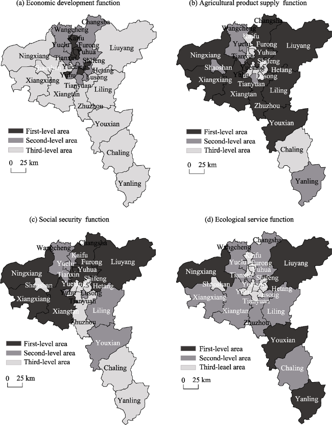
Figure 2 Classification of rural functions in the Changsha-Zhuzhou-Xiangtan urban agglomeration, 1996-2016
Growth in the economic development function has the clear characteristic of gradually decreasing from the core to the periphery of the urban agglomeration. Areas with faster growth of the economic development function are mainly concentrated in municipal districts, including the six regional units of Furong District, Tianxin District, Kaifu District, Yuhua District, Shifeng District and Yuhu District, which have an average vertical comparison coefficient of 1.201. These regions are the most developed in the agglomeration in their economies and industrial structures, and they are forerunners in the agglomeration in resource-saving and environmental efforts. They have a relatively solid foundation of economic development, and they often take the lead in the province’s gross output value and fiscal revenue. They have relatively complete industrial systems, encompassing national and provincial economic development zones and industrial parks. They also play a strong role in driving regional economic development. The second-level areas are located next to the core cities of the urban agglomeration on both the east and west sides. The third-level areas are located in the outermost parts of the Changsha-Zhuzhou-Xiangtan region, including Zhuzhou County, Shaoshan City, Xiangxiang City, Xiangtan County, Youxian County, Chaling County and Yanling County. These areas have few locational advantages as they are far from the core cities, they are reliant on single industries or have underdeveloped industries, and growth of rural economic functions is significantly below the rural areas of the core cities.
The spatial pattern of the evolution of the agricultural product supply function is the opposite of the economic development function. The first-level areas are located in peripheral counties and county-level cities, including Liuyang City and Ningxiang County. These places have large land areas with large tracts of cultivated land. They have long been known for growing rice and other food crops, as well as for their tea plantations, orchards and livestock farming in hilly areas. Per capita consumption of agricultural products is high, and there is plenty of scope for growth in rural functions. The second-level areas are located around Xiangtan and Zhuzhou, including Chaling County, Yanling County and Shaoshan County. These places have the second largest rural land areas, but they have the advantage of being close to markets, so demand for their agricultural products is high. As such, their agricultural product industrial chain is relatively complete, and their agricultural product supply function has increased in recent years. The third-level areas of the agricultural product supply function are all municipal districts. These areas have extremely high levels of urbanization and large populations. Although they have a high demand for agricultural products, agricultural land area is small and there is no large-scale agricultural cultivation. Agricultural products in these areas have, for a long time, been provided mostly by first-level areas.
The average vertical comparison coefficient for the social security function was 0.938, but 1.378 for the first- and second-level areas only, including Ningxiang County, Liuyang City, Changsha County, Furong District, Yuhua District, Xiangxiang City and Xiangtan County. The rural per capita incomes, rural power facilities and rural medical facilities of these county-level units were significantly higher or better than other county-level units in the region. This is because urbanization in the past 20 years has improved living and employment levels in rural areas, and rural industrial and social structures have been thoroughly transformed from traditional to modern over time. The third-level areas of the social security function include Tianyuan District, Yuhu District, Hetang District and Shifeng District in the heart of the agglomeration and Yanling County in the south. Although county-level areas in the center of the urban agglomeration have higher levels of urbanization and rural per capita net incomes are relatively high, the lack of power facilities and inadequate medical standards pulls down the overall level of the rural social security function.
There are only four first-level areas of ecological service function evolution, namely Ningxiang County, Liuyang City, Youxian County and Yanling County, but they account for 44% of the land area of the Changsha-Zhuzhou-Xiangtan urban agglomeration. The four county-level units have vast land areas, mountainous terrain, high levels of forest cover, and abundant eco-tourism resources. Ningxiang County and Liuyang City, in particular, have excellent natural scenery and rural cultures and are close to the core cities so they are popular with urban residents from those places. Rural ecology, tourism and agritourism have developed rapidly as a result. Yanling County is an important ecological county in the region, as it pays particular attention to rural ecological protection. It is conducting afforestation over large areas of land and developing its ecotourism industry. It has considerable ecological value. The third-level ecological service function areas include almost all the municipal districts of Changsha, Zhuzhou and Xiangtan. These county-level units have high levels of urbanization, extremely small areas of cultivated land and afforestation, limited development space, and thus poorer growth in the ecological service function.
Overall, there are large differences in the changing rural functions of county-level units in the Changsha-Zhuzhou-Xiangtan urban agglomeration, and intraregional differences in function evolution are stark. As such, dominant functions based on local advantages should be highlighted, balanced development of multi-functionality should be promoted in rural areas and the function gap should be narrowed to achieve coordinated regional development.

4.4 Driving mechanisms of rural function evolution in the Changsha-Zhuzhou- Xiangtan region

The evolution of rural functions is the result of interactions between multiple factors. These factors affect the evolutionary features, manifestations, strength and future development of rural functions in different aspects, degrees and ways. Natural resources and the environment are basic guarantees for the formation and development of rural functions. In the primary stage of a region’s development, these two factors play a decisive role in changing rural functions, and they continue to play a role throughout their evolution. Due to natural conditions and a combination of other factors, including socio-economic conditions, local transport, public infrastructure and ecological construction, rural functions evolve at different paces, which creates the overall development pattern of the urban center and rural periphery of the urban agglomeration (Figure 3).
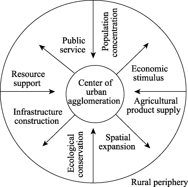
Figure 3 Development pattern of the urban center and rural periphery
When industrial transformation and spatial reconstruction began, industries in the center and periphery of the urban agglomeration started shifting and adjusting. Peripheral county-level cities and villages fed on the economic development of the urban agglomeration’s center to develop traditional industries, manufacturing and logistics. These adjustments to urban and rural industries resulted in improvements to the rural economic development function. Improvements to urban and rural travel infrastructure stimulated urban and rural population flows as well as flows of agricultural products and industrial resources, opened up rural areas of the agglomeration, and provided significant impetus to the rural economic development, agricultural product supply and social security functions.
To address such problems as the dual urban-rural structure and backward public services and infrastructure in rural areas, efforts have been made in recent years to equalize urban and rural public facilities, which has played an important role in improving the social security system and, therefore, the rural social security function. Nevertheless, any improvement in rural functions must be based on a sound ecological and resource environment. People are paying more attention to ecological issues nowadays, and there has been clear improvements in ecological issues, which has driven the development of the ecotourism industry. This means that the ecological service function is no longer restrained by the economic development function but has become an industry in its own right in rural areas. Moreover, a sound natural ecological environment is a necessary condition for rural functions to evolve to a higher level.
In the different development stages of urbanization, the development of rural functions has different characteristics, and the urban-rural mode of action, development form, industrial characteristics, driving forces and utility of rural functions are manifested differently (Figure 4).
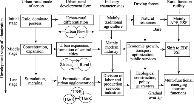
Figure 4 Evolution and driving forces of rural functions at different stages of urbanization
In the initial stage of urbanization, links between urban and rural areas are relatively weak, cities have less impact on rural areas, there is clear separation between urban and rural areas, and urban-rural differentiation is beginning to take shape. During this stage, rural functions are affected by natural conditions, and the agricultural product supply function dominates. At this point, rural areas are dependent on single industries, and the rural economic base is still in its infancy, which is represented by the fact that people mainly rely on the land to survive and on simple human and animal labor for agricultural production. The style of living and working is subsistence, and the social security function is weak. There is a low level of agricultural mechanization, but the agricultural product supply function is still the most important rural function at this stage, followed by the ecological service function. There are few rural functions in total.
In the middle stage of urbanization, as urbanization gathers pace, factors of production of urban and rural areas are constantly being adjusted and combined, and interaction between urban and rural areas is increasing. The long-term priority given to developing cities and industries means that cities are “commandeering” the resources, space and development opportunities of rural areas. The rural agricultural product supply function, cultural function and ecological service function are rapidly deteriorating or have disappeared. At this point, urban and rural areas have entered a stage of rapid industrial transformation, heavy and manufacturing industries are gradually shifting from urban areas to rural areas. Cities mainly develop high-value-added industries such as high-tech and tertiary industries, while rural areas mainly develop modern heavy and manufacturing industries, which promote the rural economic development function. As urban and rural transportation networks and urban and rural public service facilities improve, they gradually become important drivers of rural functions, which shift toward the economic development and social security functions.
In the late stage of urbanization, integration between urban and rural areas becomes more obvious, and the urban agglomeration pattern gradually takes shape. As the rural economic development function strengthens, more attention is paid to coordinating the development of production, living standards and the environment in rural areas based on the “beautiful villages” development plan. Dominant functions suited to each county-level area are strengthened and weak functions are improved, creating a new pattern of multi-functional integrated development between urban and rural areas inside and outside the urban agglomeration. Using agriculture as the jumping off point, and with the aim of developing functions adapted to the demands of urban areas, rural areas focus on creating concentrations of rural ecotourism and modern agricultural industries. They also aim to improve the rural standard of living and medical facilities as well as ecological protection, while retaining their characteristic rural landscapes and cultures to achieve the strategic goal of rural revitalization, consisting of “strong agriculture, beautiful villages and rural prosperity.”

5 Conclusions and discussion

5.1 Conclusions

(1) The Changsha-Zhuzhou-Xiangtan region showed an upswing in the evolution of its rural functions between 1996 and 2016, and the total number of rural functions increased. The key nodes influencing the development of rural functions in the region over this 20-year period were around 2000 and 2008. The regulations and policies of governments in the Changsha-Zhuzhou-Xiangtan urban agglomeration as well as the wider context of urbanization had a relatively significant impact on the rural functions of the region.
(2) The Changsha-Zhuzhou-Xiangtan region’s rural functions displayed clear regional differentiation. The economic development function showed more rapid development in central areas of the urban agglomeration, with a vertical comparison coefficient of 1.201, but lower growth in peripheral county-level units. The agricultural product supply and ecological service functions were concentrated in county-level units with abundant cultivated land and forestry resources, such as Liuyang City and Ningxiang County. The social security and economic development functions were synchronized, showing that the economic development function drives the growth of the social security function. Overall, there were significant differences in the rural functions of different county-level units in the Changsha-Zhuzhou-Xiangtan urban agglomeration, and intraregional differences in changes to functions were stark. As such, dominant functions based on local advantages should be highlighted, balanced development of multi-functionality should be promoted in rural areas and the function gap should be narrowed to achieve coordinated regional development.
(3) The evolution of rural functions was the result of interactions between multiple factors, including natural conditions, socio-economic conditions and local transport conditions, with different factors acting as the dominant influence on rural functions at different stages of urbanization. In the initial stage of rural development, the rural functions of agricultural product supply and ecological service were dominant. When rural areas entered the stage of industrial transformation, the economic development and social security factors increased and, in particular, there was sudden growth in the economic development function. Subsequently, as rural areas entered the multifunctional integrated development stage, coordinated development of production, living standards and the environment constantly deepened, there was comprehensive and balanced development of each function, and the ecological service function increased rapidly in importance.

5.2 Discussion and prospects

This study looked at the evolution and driving forces of rural functions of the Changsha-Zhuzhou-Xiangtan urban agglomeration over a continuous time period. It supplemented and improved content on dynamic changes in research on rural functions, which holds important practical significance for promoting urban and rural planning and the regional division of labor of rural functions. Nevertheless, research on interactions between functions has not gone far enough. In the future, it will be necessary to address new challenges urban functions may encounter in the course of urban agglomeration development to understand future trends. In particular, there is a need for deep theoretical research on issues such as mechanisms for enhancing and ways of controlling rural functions in the course of urban-rural transformation and reconstruction. Methods and directions of rural development in the future should take into consideration the development background and actual characteristics of rural areas, optimize advantageous functions and the factors that drive them, and adapt to the requirements of the Rural Revitalization Strategy, so as to become the core driving force of that revitalization, create a development pattern that is coordinated and has great potential, and achieve the integrated development of urban and rural areas.
[1]
Fang Y G, Liu J S , 2015. Diversified agriculture and rural development in China based on multifunction theory: Beyond modernization paradigm. Acta Geographica Sinica, 70(2):257-270. (in Chinese)

[2]
Hamblin A , 2009. Policy directions for agricultural land use in Australia and other post-industrial economies. Land Use Policy, 26(4):1195-1204.

[3]
He Y H, Fan S G, Zhou G H et al., 2018. Evaluation of rural transformation development in Hunan Province based on major function oriented zoning. Progress in Geography, 37(5):667-676. (in Chinese)

[4]
Holmes J , 2006. Impulses towards a multifunctional transition in rural Australia: Gaps in the research agenda. Journal of Rural Studies, 22(2):142-160.

[5]
Holmes J , 2012. Cape York Peninsula, Australia: A frontier region undergoing a multifunctional transition with indigenous engagement. Journal of Rural Studies, 28(3):252-265.

[6]
Hong H K, Liao H P, Li T et al., 2016. Analysis of spatio-temporal patterns of rural space function based on entropy value method and Dagum Gini coefficient. Transactions of the Chinese Society of Agricultural Engineering, 32(10):240-248. (in Chinese)

[7]
Li P X, Chen W, Sun W , 2014. Spatial differentiation and influencing factors of rural territorial multifunctions in developed regions: A case study of Jiangsu Province. Acta Geographica Sinica, 69(6):797-807. (in Chinese)

[8]
Li Z, Zhang X L, Li H B et al., 2017. Research on rurality at village scale and rural development model: A case of Jintan City, Jiangsu Province. Scientia Geographica Sinica, 37(8):1194-1202. (in Chinese)

[9]
Liu Y, Liu Y S , 2012. Progress and prospect in the study of rural region multifunctions. China Population, Resources and Environment, 22(10):164-169. (in Chinese)

[10]
Liu Y, Liu Y S, Guo L Y , 2013. SOFM-based functional subareas of rural area along the Bohai Rim in China. Human Geography, 28(3):114-120. (in Chinese)

[11]
Liu Y S, Liu Y, Chen Y F , 2011. Territorial multi-functionality evaluation and decision-making mechanism at county scale in China. Acta Geographica Sinica, 66(10):1379-1389. (in Chinese)

[12]
Liu Z Q, Zhou A L, Lu Q , 2012. The transition of rural territorial leading function and the classification of rural development stages. Journal of Arid Land Resources and Environment, 26(4):49-54. (in Chinese)

[13]
Long H L , 2012. Land use transition and rural transformation development. Progress in Geography, 31(2):131-138. (in Chinese)

[14]
Long H L, Zhang X N , 2012. Progress in international rural geography research since the turn of the new millennium and some implications. Economic Geography, 32(8):1-7, 135. (in Chinese)

[15]
McCann T, Cooper A, Rogers D et al., 2017. How hedge woody species diversity and habitat change is a function of land use history and recent management in a European agricultural landscape. Journal of Environmental Management, 196:692-701.

[16]
Ondetti G , 2016. The social function of property, land rights and social welfare in Brazil. Land Use Policy, 50:29-37.

[17]
Stola W , 1984. An attempt at a functional classification on rural areas in Poland: A methodological approach. Geographia Polonica, 50:113-129.

[18]
Tan X L, An Y, Su Y et al., 2018. Spatio-temporal dynamics of agricultural function in Changsha-Zhuzhou- Xiangtan urban agglomerations. Scientia Geographica Sinica, 38(5):708-716. (in Chinese)

[19]
Tan X L, Ouyang Q L, Yu S Y et al., 2017. Knowledge structure of rural function in China: An analysis based on Citespace map. Economic Geography, 37(10):181-187. (in Chinese)

[20]
Tan X L, Yu S Y, Ouyang Q L et al., 2017. Assessment and influencing factors of rural hollowing in the rapid urbanization region: A case study of Changsha-Zhuzhou-Xiangtan urban agglomeration. Geographical Research, 36(4):684-694. (in Chinese)

[21]
Tang C L, He Y H, Zhou G H et al., 2014. The research on optimization mode of spatial organization of rural settlements oriented by life quality. Acta Geographica Sinica, 69(10):1459-1472. (in Chinese)

[22]
Tang C L, He Y H, Zhou G H et al., 2018. Optimizing the spatial organization of rural settlements based on life quality. Journal of Geographical Sciences, 28(5):685-704.

[23]
Todorova S, Ikova J , 2014. Multifunctional agriculture: Social and ecological impacts on the organic farms in Bulgaria. Procedia Economics and Finance, 9:310-320.

[24]
Zhang Y N, Long H L, Ma L et al., 2018. Farmland function evolution in the Huang-Huai-Hai Plain: Processes, patterns and mechanisms. Journal of Geographical Sciences, 28(6):759-777.

[25]
Zhen L, Wei Y J, Xie G D , 2010. Regional analysis of dynamic land use functions in China. Acta Ecologica Sinica, 30(24):6749-6761. (in Chinese)

[26]
Zhou G H, Chen L, Tang C L et al., 2018. Research progress and prospects on Changsha-Zhuzhou-Xiangtan urban agglomeration. Economic Geography, 38(6):52-61. (in Chinese)

Outlines

/