Rainfall interception of typical ecosystems in the Heihe River Basin: Based on high temporal resolution soil moisture data

  • YANG Chongyao ,
  • HUANG Yongmei , * ,
  • LI Engui ,
  • LI Zeqing
Expand
  • State Key Laboratory of Earth Surface Processes and Resource Ecology, Faculty of Geographical Science, Beijing Normal University, Beijing 100875, China
*Huang Yongmei (1974-), Professor, specialized in vegetation ecology and ecohydrology. E-mail:

Yang Chongyao (1994–), Master, specialized in vegetation ecology and ecohydrology. E-mail: 201621190006@mail.bnu.edu.cn

Received date: 2018-10-23

  Accepted date: 2019-03-16

  Online published: 2019-12-11

Supported by

National Natural Science Foundation of China(No.91425301)

National Natural Science Foundation of China(No.91725000)

State Key Laboratory of Land Surface Processes and Resource Ecology(No.2017-ZY-04)

Copyright

Copyright reserved © 2019. Office of Journal of Geographical Sciences All articles published represent the opinions of the authors, and do not reflect the official policy of the Chinese Medical Association or the Editorial Board, unless this is clearly specified.

Abstract

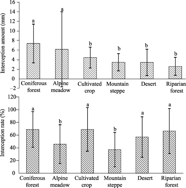
Rainfall interception is of great significance to the fully utilization of rainfall in water limited areas. Until now, studies on rainfall partitioning process of typical ecosystems in Heihe River Basin, one of the most important inland river basins in China, is still insufficient. In this study, six typical ecosystems were selected, namely alpine meadow, coniferous forest, mountain steppe, desert, cultivated crop, and riparian forest, in Heihe River Basin for investigation of the rainfall interception characteristics and their influencing factors, including rainfall amount, duration, and intensity, based on the gross rainfall and high temporal resolution soil moisture data obtained from 12 automatic observation sites. The results show that the average interception amount and average interception rate of the six ecosystems are significantly different: alpine meadow 6.2 mm and 45.9%, coniferous forest 7.4 mm and 69.1%, mountain steppe 3.5 mm and 37.3%, desert 3.5 mm and 57.2%, cultivated crop 4.5 mm and 69.1%, and riparian forest 2.6 mm and 66.7%, respectively. The rainfall amount, duration, and intensity all had impact on the process of rainfall interception. Among these three factors, the impact of rainfall amount was most significant. The responses of these ecosystems to the rainfall characteristics were also different. Analyzing rainfall interception with high temporal resolution soil moisture data is proved to be a feasible method and need further development in the future.

Cite this article

YANG Chongyao , HUANG Yongmei , LI Engui , LI Zeqing . Rainfall interception of typical ecosystems in the Heihe River Basin: Based on high temporal resolution soil moisture data[J]. Journal of Geographical Sciences, 2019 , 29(9) : 1527 -1547 . DOI: 10.1007/s11442-019-1675-1

1 Introduction

Rainfall interception is one of the most important hydrological processes, which affects the water balance at multi-scales (Llorens and Domingo, 2007). Rainfall changes its transportation route when it goes through the vegetation canopies, partitioning into interception, throughfall, and stemflow, among which interception, further composed of two parts, evaporation and canopy water storage (Crockford and Richardson, 2000; Staelens et al., 2008), causes a water loss from the vegetation (Loik et al., 2004), throughfall leads to the spatial variability of the pattern of the rainfall that can reach the ground (Weltzin and Macpherson, 2000), and stemflow can reach deeper layers of the soil and increase the available water for the roots (Martinez-Meza and Whitford, 1996; Li et al., 2009). In general, rainfall partitioning process leads to a significant redistribution of incident rainfall (Llorens and Domingo, 2007), and becomes an important part in the hydrology, especially in water limited regions.
Traditional rainfall interception experiments in shrub and forest ecosystems always set a series of collectors beneath the canopies to receive throughfall, fit collars around the entire circumference of the stem of the plants to collect stemflow, and calculate interception loss from the difference between the bulk rainfall and the sum of the throughfall and stemflow (Crockford and Richardson, 2000; Llorens and Domingo, 2007; Zhang et al., 2015). Throughfall collectors need to be weighed and emptied after every rainfall event, make it difficult to realize automatic, real-time observation of rainfall interception process in a single rainfall event. A large number of self-recorded rainfall measuring devices are needed to achieve high temporal resolution of automatic observation, which is more expensive and difficult to manage. Moreover, most rainfall interception experiments focus on forest and shrub communities, whose method is not suitable for herbaceous plants because their height is much lower (Wohlfahrt et al., 2006; Li et al., 2009). Current methods often cause damage to the measured herbaceous plants (Monson et al., 1992; Fan et al., 2015). In recent years, with the development of automatic soil moisture measurement technology, high temporal resolution soil moisture data of multiple layers can be obtained (Bogena et al., 2010). These data have been widely used to realize fine depiction of soil moisture dynamics (Liu et al., 2015; Hu et al., 2017; Wang et al., 2017), and to analyze ecosystem evapotranspiration (Dekker et al., 2007; Soubie et al., 2016; Xu et al., 2017). Based on the same principle of water balance, rainfall interception can also be depicted by the relationship between rainfall amount and soil moisture dynamic during the individual rainfall event. The increase in soil moisture content can be considered as the result of the infiltration of the throughfall and stemflow, while the difference between the bulk rainfall and the increase of soil moisture is mainly caused by the interception loss (Herbst et al., 2008; Staelens et al., 2008). This method can be an appropriate alternative of the traditional methods to achieve fine description of rainfall partitioning, and solve the problems that traditional experiments are difficult to achieve automatic and non-destructive observation of herbaceous communities (Yu et al., 2012).
As China’s second largest inland river, the Heihe River originates from the Qilian Mountains, and flows through Qinghai, Gansu, and Inner Mongolia provinces (Li et al., 2001). Due to its great elevation gradient and different climate, the Heihe River Basin has a wide variety of unique ecosystems, consisting of alpine vegetation, oases, deserts, and riparian forest landscapes (Li et al., 2013; Liu et al., 2015; Fu and Pan, 2016). From the river’s upper reaches in the south to the lower reaches in the north, multiple physiogeographic units of the Heihe River Basin make it ideal for studying soil moisture dynamics and rainfall partitioning on the basin scale (Wang et al., 2009). Many studies on rainfall infiltration and partitioning have been carried out in the Heihe River Basin so far (Tan et al., 2009; Liu et al., 2012; Yang et al., 2012; Xu et al., 2013; Peng et al., 2014; Wan et al., 2016). However, traditional methods are mostly used, with rare reports of rainfall partitioning based on high temporal resolution soil moisture data. In addition, these studies are basically carried out in the spruce forest and shrub ecosystems in the upper reaches (Xu et al., 2013; Peng et al., 2014; Wan et al., 2016), with the lack of studies on alpine meadow, mountain steppe, and riparian forest ecosystems. In recent years, the synthetic research on the eco-hydrological process of the Heihe River Basin and the Heihe Watershed allied telemetry experimental research (HiWATER) experiment have built an integral observation system and data platform (Li et al., 2013; Cheng et al., 2014). The soil moisture observation network covers all the typical ecosystems in the basin and has achieved a large amount of automatic observation data of soil moisture, which make it possible to analyze the process of rainfall infiltration and partitioning. The specific objective of this study is to make out: (1) what are the similarities and differences of rainfall partitioning characteristics of different ecosystems in the Heihe River Basin; (2) which factors can influence the process of rainfall partitioning; and (3) whether high-resolution soil moisture data can be used to calculate rainfall interception.

2 Materials and methods

2.1 Study area

As the second largest inland river in China, the Heihe River is 821 km long with a drainage area of 1.429 × 10⁵ km2. The river basin located in the arid and semi-arid region of northwest China, roughly between 37°44°-42°40°N and 97°37°-102°06°E (Figure 1). The upper reaches are located in the Qilian Mountains, on the northern margin of the Qinghai-Tibet Plateau with an elevation of more than 2000 m a.s.l. The climate in this region is characterized by large amount of precipitation, low temperature and evaporation, with regional mean annual temperature ranging from -5 to 4℃, mean annual precipitation of 250-500 mm, and annual evapotranspiration of 700-2000 mm. The middle reaches are flat, located at the east of the Hexi Corridor, with altitudes ranging from 1000-2000 m. Compared to the upper reaches, the climate of middle reaches is arid, with less precipitation, more evapotranspiration, and higher temperature. From the southwest to the northeast in this region, mean annual precipitation decreases from 200 mm to 55 mm, while the annual evapotranspiration increases from 1200 mm to 2200 mm. The lower reaches are located on the Alshan Plateau in the west of Inner Mongolia Plateau, with altitudes ranging from 980-1200 m. This area has less precipitation but stronger evaporation. The average annual precipitation is only 47.3 mm, while the average annual evaporation is as high as 2249 mm. The mean annual temperature is 8.2℃ (Pan and Tian, 2011).
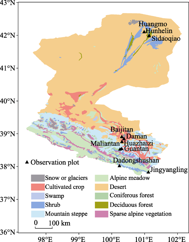
Figure 1 Ecosystem distribution and the field observation sites of the Heihe River Basin
As can be seen from Figure 1, over 80% of the Heihe River Basin is covered by five ecosystems, namely, alpine meadow, coniferous forest, desert, mountain steppe, and cultivated crop. The riparian forest ecosystem, on the other hand, is a unique ecosystem developed in the inland river basin, and is of great significance for studying the eco-hydrological processes in this area. Therefore, these six ecosystems were selected as typical ecosystems in the Heihe River Basin (Table 1).
Table 1 Stand characteristics and mean annual climate conditions of typical ecosystems
Ecosystems Coverage (%) Canopy height (m) Mean annual precipitation (mm) Mean annual temperature (℃)
Alpine meadow 90-100 0.03-0.09 411.7 -1.10±1.53
Coniferous forest 60-80 16-30 589.1 1.46±0.38
Mountain steppe 70-90 0.15-0.4 506.5 1.11±1.03
Desert 10-30 0.3-0.6 95.4 8.99±0.32
Cultivated crop 80-90 1.8-2.0 129.0 6.35±0.29
Riparian forest 30-50 10-20 40.2 9.76±0.49
Alpine meadows are located on the alpine and subalpine slopes at altitudes of 3000-4200 m, mainly dominated by Kobresia sp. The plant communities often have a large coverage, simple structure, and low grass layer. The soil is mainly alpine meadow soil, which is thin and rich in organic matter. Coniferous forests are located in the mountainous shady and semi-shady slopes at an altitude of 2400-3400 m a.s.l., and often accompanied with the steppe on the sunny and semi sunny slope, forming a compound distribution of mountain forest steppe ecotone. Picea crassifolia is the constructive species in the coniferous forests. The soil is mainly mountain gray cinnamon soil, with thin layer, coarse texture, and medium content of organic matter. Deserts are distributed in arid areas, with annual precipitation less than 200 mm but intense evaporation. Desert is dominated by xeric small trees, subshrubs, shrubs, or succulent plants. The soil in this area is thin, coarse, and lack of organic matter. Cultivated crop lands in the arid desert areas need sufficient water for irrigation, so they are mainly distributed in the middle reaches. Corns and vegetables are the main crops. The riparian forests are growing under the arid desert climate. The constructive species of the riparian forests, Populus euphratica, can adapt to the habitat, whose atmosphere is dry while the soil is humid. The shrub layer is dominated by Tamarix ramosissima. Saline soil is the main soil type in this ecosystem.

2.2 Rainfall and soil moisture content data collection

Data of 12 sites (Table 2) produced by the Heihe Watershed allied telemetry experimental research (HiWATER) experiment was downloaded from http://www.heihedata.org/, including water content of different soil layers, and climate factors such as air temperature and rainfall (Liu et al., 2011; Li et al., 2013; Liu et al., 2018). Measurements of soil moisture in each experimental station used CS616 water content reflectometers produced by Campbel Company of the United States (Campbell Scientific, 2006). Soil moisture sensors were installed at 4, 10, 20, 40, 80, 120 and 160 cm in most sites. The moisture contents were logged continuously with a 10-min interval during the observation period. Precipitation was measured by the TE525 sensor produced by Campbell Company, which also recorded data every 10 minutes. Rainfall partitioning data measured by traditional method was also downloaded to verify the calculating results.
Table 2 Selected eco-hydrological observation sites of the Heihe River Basin
No. Site Ecosystems Dominant species Altitude (m a.s.l.) Observation period
1 Dadongshushan Alpine meadow Kobresia pygmaea 4101 2008
2 Jingyangling Alpine meadow Kobresia pygmaea 3750 2014-2016
3 Guantan Coniferous forest Picea crassifolia 2835 2008-2011
4 Maliantan Mountain steppe Iris lacteal var. chinensis + Stipa krylovii 2817 2008-2009
5 Pailugou Mountain steppe Stipa krylovii 2731 2006-2007
6 Hulugou Mountain steppe Stipa penicillata 2980 2011
7 Huazhaizi Desert Kalidium foliatum 1731 2013-2016
8 Bajitan Desert Reaumuria songarica 1562 2015
9 Daman Cultivated crop Zea mays 1556 2013-2016
10 Sidaoqiao Riparian forest Tamarix chinensis 873 2014-2016
11 Hunhelin Riparian forest Populus euphratica 874 2014-2016
12 Huangmo Desert Reaumuria songarica 1054 2015-2016

2.3 Methods of rainfall partitioning calculation

The soil moisture data are selected for each rainfall event, based on the criterion of the minimum inter-event time (6 hours), which is a minimum time lapse without precipitation between two rainfall events (David et al., 2006; Dunkerley, 2008). Rainfall partitioning calculation starts with the calculation of accumulated infiltration quantity:
$I=\sum\nolimits_{i=1}{({{\theta }_{ei}}-{{\theta }_{i}})\times k}$
where I is the rainfall infiltration (mm), θei is the volume water content of the soil layer i after the rain (cm3·cm-3), θi is the volume water content of the soil layer i before the rain start (cm3·cm-3) , k is the thickness of the soil layer i (mm) (Wang et al., 2003).
The rainfall infiltration content I is the sum of the throughfall (TF) and stemflow (SF). So the interception amount, IL (mm,) was calculated as
IL = GR - (SF +TF) = GR - I
where GR is gross rainfall amount (mm) in the open area.
Because rainfall < 2 mm can hardly cause the fluctuation of soil moisture (Li et al., 2013), the amount of interception could not be calculated by infiltration amount in this case, and this part of rainfall events was basically ignored in the calculation.
We also drew the scatter plot and regression line to show the relationship between precipitation and rain interception.

2.4 Statistical analyses

We use one way ANOVA to analyze the differences of rainfall partitioning among the ecosystems. Pearson correlation was used to analyze the correlations between interception and rainfall characteristics. We also used multiple linear regressions to determine dominant rainfall characteristic. The descriptive statistics were performed using SPSS 20.0.

3 Results

3.1 Rainfall characteristics

For most of the ecosystems, precipitation in August was the highest, while the frequency did not show a certain regularity (Figure 2). Among all the ecosystems, alpine meadow had the highest rainfall amount ranged from 71.5 mm in June and 128 mm in August, with an average frequency of 10 each month. The riparian forest had the lowest monthly rainfall amount, which was only 10.2-28.8 mm. The mean frequency of rainfall events for all ecosystems except the alpine meadow was less than 5 times per month, in comparison with 1.8 times for the riparian forest.
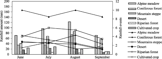
Figure 2 Monthly amount and frequency of rainfall events in growing season for typical ecosystems (Bars show the monthly rainfall amount, and lines show the rainfall events)
The most rainfall events were observed in alpine meadow (148 times), while the least was observed in riparian forest (28 times) (Table 3). The average rainfall amount was 3.9-14.7 mm for these ecosystems, and the average rainfall intensity was 0.7-1.2 mm/h (Table 3).
For all the ecosystems, 5-10 mm rainfall events occurred most frequently, with the highest contribution to the annual rainfall amount (Table 4). The 10-15 mm rainfall events also contributed largely to both the annual rainfall amount and events in most of the ecosystems. Although the heavy rainfall events (>20 mm) were less frequent, they contribute much to the rainfall amount. It should be noted that only precipitation of <10 mm was observed in the riparian forest, which had the driest climate.
Table 3 Average rainfall characteristics of typical ecosystems during observation period
Ecosystems Observed rainfall events Average rainfall amount (mm) Average rainfall intensity (mm/h)
Coniferous forest 45 14.7 1.0
Alpine meadow 148 9.8 1.0
Cultivated crop 46 7.2 0.9
Mountain steppe 38 13.3 0.9
Desert 88 7.6 1.2
Riparian forest 28 3.9 0.7
Table 4 Frequency distribution of rainfall events
Rainfall event (mm) Alpine meadow Coniferous forest Mountain steppe
Frequency RP** (%) Frequency RP (%) Frequency RP (%)
Times TP* (%) Times TP (%) Times TP (%)
0-2 8 5.52 0.83 0 0.00 0.00 1 2.63 0.38
2-5 44 30.34 10.35 3 9.68 2.13 4 10.53 3.10
5-10 44 30.34 21.27 10 32.26 14.87 15 39.47 23.61
10-15 23 15.86 19.07 7 22.58 17.21 7 18.42 17.57
15-20 12 8.28 14.30 4 12.90 14.18 4 10.53 13.84
20-30 10 6.90 16.92 2 6.45 9.50 4 10.53 19.68
30-40 2 1.38 11.22 4 12.90 27.90 2 5.26 13.90
40-50 2 1.38 6.03 1 3.23 14.20 1 2.63 7.92
Rainfall event (mm) Desert Riparian forest Cultivated crop
Frequency RP (%) Frequency RP (%) Frequency RP (%)
Times TP (%) Times TP (%) Times TP (%)
0-2 5 5.68 1.07 9 32.14 13.96 2 4.35 1.09
2-5 28 31.82 14.01 12 42.86 41.31 14 30.43 15.95
5-10 33 37.50 34.39 7 25.00 44.74 23 50.00 50.80
10-15 14 15.91 25.18 0 0.00 0.00 3 6.52 9.65
15-20 5 5.68 12.66 0 0.00 0.00 3 6.52 15.83
20-30 2 2.27 8.07 0 0.00 0.00 1 2.17 6.67
30-40 1 1.14 4.62 0 0.00 0.00 0 0.00 0.00
40-50 0 0.00 0.00 0 0.00 0.00 0 0.00 0.00

*TP means the percentage of rainfall times. **RP means the percentage of rainfall amount.

3.2 Rainfall interception of different ecosystems

The average value of the interception amount and interception rate for each ecosystem were calculated by the difference between the rainfall amount and infiltration (Figure 3). The interception amount of coniferous forest and alpine meadows were the largest, and are significantly higher than the other four types of ecosystems (Figure 3). The alpine meadow and mountain steppe had the lowest interception rates, which were significantly lower than the others (Figure 3).
Figure 3 Average interception amount and rate of single rainfall events for each type of ecosystem
The accumulative rainfall interception with rainfall events in different ecosystems (Figure 4) showed that coniferous forest intercepted almost all the rainfall at the beginning of the rainfall event, while the desert intercepted rainfall along the rainfall event. The interception amount reached the maximum more quickly in alpine meadow and mountain steppe than other ecosystems.
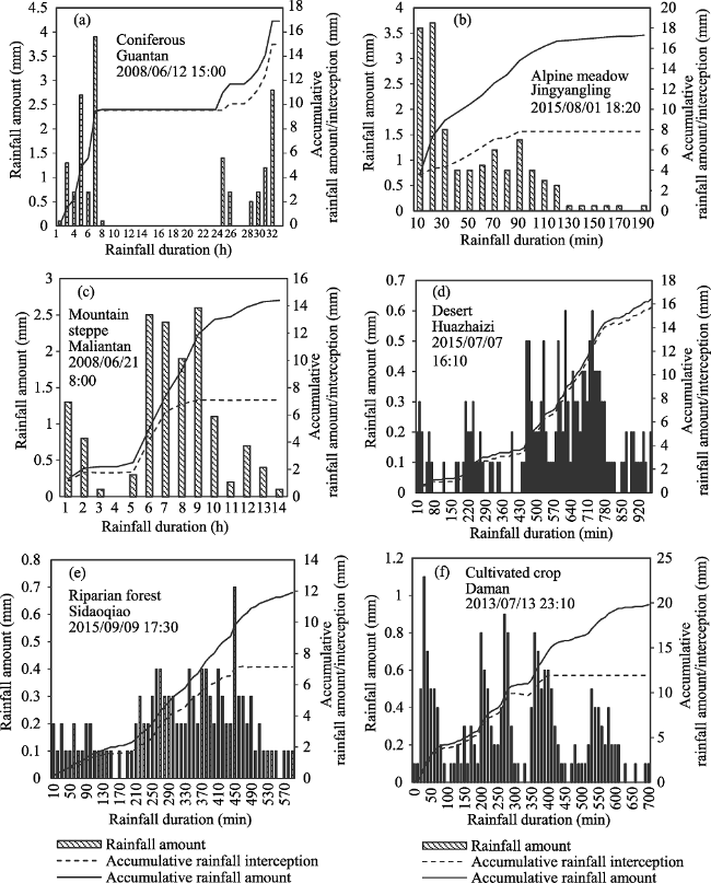
Figure 4 Rainfall interception dynamic during single rainfall event

3.3 Influencing factors of rainfall interception

3.3.1 Relationship between rainfall interception and rainfall amount
Significantly positive relationships were found between individual rainfall amount and interception amount for alpine meadow, coniferous forest, desert, and riparian forest, while no relationships were shown in mountain steppe and cultivated crop (Figure 5). The interception rate decreased exponentially with increasing rainfall amount in alpine meadow, mountain steppe, and desert, but it tends to be a constant in alpine meadow, when the rainfall event is more than 10 mm. The interception rate of cultivated crop, coniferous forest, and riparian forest didn’t show any clear relationship with rainfall amount.
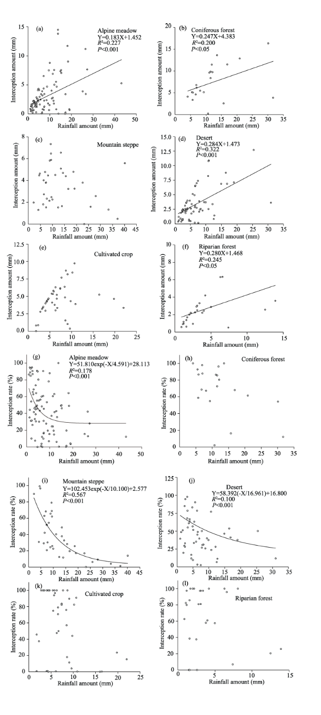
Figure 5 Rainfall partitioning as a function of individual rainfall amount (a)-(f) shows the relationship between rainfall amount and interception amount, (g)-(l) shows the relationship between rainfall amount and interception rate
3.3.2 Relationship between rainfall interception and rainfall duration
Except for cultivated crop, all the ecosystems showed significant relationship between rainfall duration and interception amount, with a negative correlation for only mountain steppe (Figure 6). Alpine meadow and mountain steppe had significant negative exponential relationship between rainfall duration and interception rate (Figure 6).
3.3.3 Relationship between rainfall interception and rainfall intensity
Only alpine meadow and coniferous forest had significant relationship between interception amount and rainfall intensity, but they showed the opposite trends (Figure 7). The intercep-tion rate decreased exponentially with increasing rainfall intensity in mountain steppe, cul- tivated crop, coniferous forest, and desert (Figure 7). With the increase of rainfall intensity, the interception rate of the mountain steppe and desert became stable at about 40%, while that value of the cultivated crop was higher (about 60%).
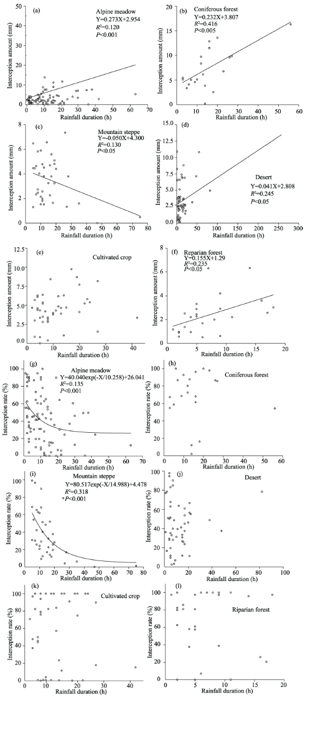
Figure 6 Rainfall partitioning as a function of individual rainfall duration (a)-(f) the relationship between rainfall duration and interception amount; (g)-(l) the relationship between rainfall duration and interception rate
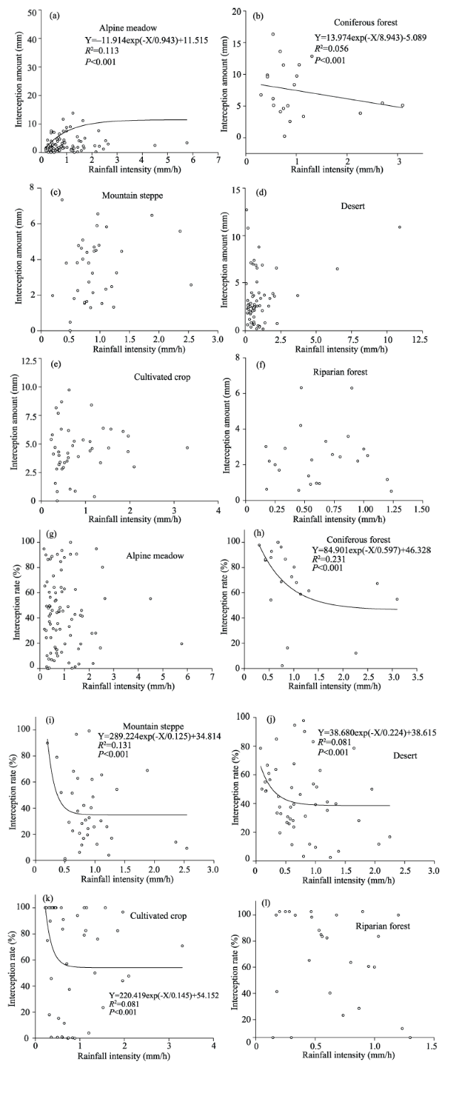
Figure 7 Rainfall partitioning as a function of individual rainfall intensity (a)-(f). the relationship between rainfall intensity and interception amount; (g)-(l) the relationship between rainfall intensity and interception rate

4 Discussion

4.1 Differences of rainfall characteristics and interception of the typical ecosystems

Alpine meadow received most rainfall amount during the growing season (362.8 mm) among all the ecosystems, followed by mountain steppe. The rainfall amount of riparian forest, desert, and cultivated crop were all less than 100 mm, with the minimum value of 27.2 mm for riparian forest. The pattern of bulk rainfall interception amount in growing season was almost the same as that of bulk rainfall amount, with the only difference that the bulk interception of coniferous forest was higher than the mountain steppe, contrary to the rainfall amounts. Differences of average interception amount and rate of single rainfall events in these ecosystems showed in Figure 3 had different patterns with those of bulk rainfall amounts. A summary of the results of a series of rainfall interception researches in different ecosystems (Table 5) showed that the rainfall interception rate of coniferous forest and cultivated crop were the highest among all the ecosystems, which was consistent with this study. Research of Liu and Zhao (2009) in the desert in the middle reach of Heihe River showed extremely high interception amount (> 5 mm), because this result was made out under a single rainfall event with the rainfall amount as high as 67.0 mm being very rare in the desert. When ignoring this extreme high value, alpine meadow and coniferous forest, studied in the same area as ours, had the highest interception amounts, also similar as the result of this study.
Table 5 Rainfall interception of different researches

4.2 Influence of vegetation characteristics on rainfall interception

One-way ANOVA analysis shows that interception amounts of coniferous forest and alpine meadow were significantly higher than those of the others (Figure 3). Among the studied ecosystems, the coniferous forest had the largest canopy height, the large canopy, and complex canopy structure, and thus a great ability to hold rain water. Hu et al. (2004) found that in the south of the Qilian Mountains, the Picea crassifolia forests, as the climax community in this area, grew well, had a great physiognomy, and thus gain the highest interception amount among all the communities. The coverage of alpine meadow in this study was as high as 90%-100%, which was the highest among all the ecosystems. Generally, the compact community structure allows the vegetation canopy to intercept more rainfall. Hu et al. (2004) found that the interception amount of the herbaceous layers with a coverage close to 100% was only 6.5% lower than the average of the 25 forest communities studied in the south of the Qilian Mountains. The multiple regression models of the interception, based on the vegetation coverage, rainfall intensity, and rainfall duration, also show that there is a positive, linear correlation between the interception amount and the vegetation coverage in the alpine meadow in the Qinghai-Tibet Plateau (Li et al., 2009).
The interception rates of alpine meadow and mountain steppe were significantly lower than those of the other four ecosystems. The interception amount of alpine meadow increased very slowly with the increase of rainfall, so the interception rate was also low. The interception amount of mountain grassland was not significantly related to the precipitation, but the interception rate decreases rapidly with the increase of rainfall amount. Due to the much lower canopy height and leaf area index than other ecosystems, the rainfall exceeding the water storage capacity of the canopy of alpine meadow and mountain steppe was almost all infiltrated. The constructive species of alpine meadow is Kobresia pygmaea, while that of mountain steppe is Stipa sp. Li et al. (2009) found that the Kobresia and Stipa species always have small leaves with large leaf angle, in the process of rainfall assembling, the stemflow is formed when the gravity exceeds the surface tension of the water drops, and is rapidly infiltrated, so the interception rate is low. In general, plant traits are one of the most influential factors for rainfall interception.

4.3 Influence of rainfall characteristics on rainfall interception

Various studies showed that, for a particular ecosystem, rainfall characteristics have a critical impact on rainfall interception (Ma et al., 2012; Zhang et al., 2015). The results of Pearson correlation analysis and stepwise regression analysis of the integration of all ecosystem data in this study (Tables 6 and 7) showed that rainfall amount, duration, and intensity can all influence the rainfall interception, especially rainfall amount.
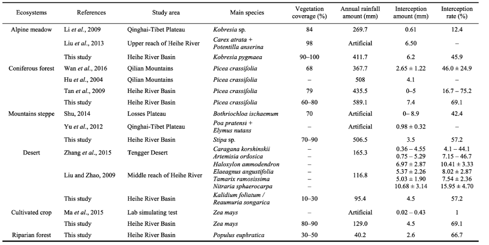
Table 6 Pearson correlation analysis between interception and rainfall characteristics
Interception Rainfall amount (mm) Rainfall duration (h) Rainfall intensity (mm/h)
Amount (mm) 0.604** 0.222** 0.200**
Rate (%) -0.420** -0.130* 0.012

* Significant correlation at 0.05 level; ** significant correlation at 0.01 level.

Table 7 Results of stepwise regression analysis
Dependent variable Variables entered Adjusted R2 P value Formula
Interception amount P 0.362 0.000 I=0.448P+0.991
Interception rate P 0.173 0.000 IR=0.020P+0.714
Almost all ecosystems showed the trend that interception amount increases with the increase of rainfall, but the interception rate decreases. Interception amount and rate of cropland seem not to be associated with rainfall amount, probably because the study period was from June to September, when the corns are growing vigorously, with the traits such as height, coverage, biomass, and leaf area index changing sharply,causing a great difference in the interception process. The slope of regression line between rainfall amount and interception amount in desert and riparian forest is the largest, which may be caused by the climate in these two ecosystems. The dry climate causes strong evaporation and adds to the interception amount. The trend of the interception rate showed that most of the interception occurred in the small rainfall events, confirming the results of Price and Carlyle-Moses (2003) and Staelens et al. (2008). At the same time, at the beginning of the rainfall events, a large portion of the precipitation was intercepted in the canopy of plants. Along with the increase of rainfall, canopy get saturated and reaches its maximum water storage capacity, then most of the rainfall turn into throughfall and stemflow, so the interception rate decreased. In this process, the increase of interception amount was mainly caused by evaporation, an important component of interception, as indicated by Navar et al. (1999) and Carlyle-Moses (2004).
The correlation between rainfall duration and interception amount in mountain steppe showed an opposite trend with the others. The leaves of the plants growing in the mountain steppe are generally small. When the rainfall duration increases, the previous interception converges into water drops and falls down, reducing the amount of interception. This situation was also observed in the swamp meadow dominated by Stipa aliena on the Qinghai-Tibetan Plateau (Li et al., 2009).
Alpine meadow is the only ecosystem with increasing rate of interception amount slows down with the increase of rainfall intensity and tends to be stable, similar to the alpine meadow on the Qinghai-Tibet Plateau (Li et al., 2009), shrub in Tengger Desert (Zhang et al., 2015), and alpine vegetation in Qinghai (Ma et al., 2012). In contrast, Liu et al. (2013) found that the relationship between the interception amount and rainfall intensity fit a unimodal curve, which increases first and then reduces. Interception amount decreased with rainfall amount in coniferous forest in this study. Li et al. (2009) brought out that when the rainfall intensity is large, the impact force on the leaf surface is strong, which is not conducive to the adsorption and storage of the rainfall, and the original partial interception on the leaf surface will also fall down. Bellot and Escarre (1998) and Owens et al. (2006) also found that rainfall of high intensity may yield lower interception and higher net rainfall.

4.4 Suitability of the method to calculate rainfall interception using high temporal resolution soil moisture data

As a sophisticated method which has been widely used in the calculation of evapotranspiration, analysis of hydrological process with high temporal resolution soil moisture data has been proved to be efficient (Dekker et al., 2007; Soubie et al., 2016; Xu et al., 2017). Yu et al. (2012) also found that the rainfall interception estimated using the water budget method (interception equals to the difference between bulk rainfall amount and the increase of soil moisture) has a significant positive correlation with that gained by the traditional methods (R2=0.78). Meanwhile, compared to the other related literatures (Table 5), it was found that the results of rainfall partitioning process calculated by high temporal resolution soil moisture data in this study were basically within a reasonable range. However, there are still some restrictions on the use of this method, such as the inability to analyze the process of interception of small rainfall that cannot cause soil moisture fluctuations. In some rainfall events, the infiltration is greater than the rainfall amount, which produces a negative interception. In spite of these, this method is very obvious for the fine depiction of the partitioning process in an individual rainfall event. Therefore, the advantages of this method can be fully brought into the analysis of the event of more than a certain amount of precipitation after calibration by the traditional method. It also needs to be further explored and optimized to realize the description of ecosystem hydrological process more accurately based on small number of experimental observations by the re-analysis of high temporal resolution soil moisture in the future (Ochsner et al., 2013).

5 Conclusions

(1) Rainfall characteristics including rainfall amount, frequency, and intensity of typical ecosystems in the Heihe River Basin were different. Among the ecosystems, the alpine meadow had the highest total rainfall amount and rainfall frequency in growing season. The 5-10 mm and 10-15 mm rainfall events occurred most in all ecosystems, with the highest contribution to both rainfall amount and frequency, while larger rainfall events (>20 mm) always contributed much to the rainfall amount.
(2) Significant differences in interception amount were found among the six ecosystems. Interception amount of coniferous forest (7.4 mm) and alpine meadow (4.2 mm) are significantly higher than the others. The interception rates of the six ecosystems are coniferous forest > cultivated crop > riparian forest > desert > alpine meadow > mountain steppe. The interception rates of alpine meadow and mountain steppe are significantly lower than the others.
(3) These typical ecosystems have different rainfall partitioning process. Coniferous forest intercepted almost all the rainfall at the beginning of the rain. Desert intercepted most rainfall during all the process. Interception amount reached the maximum more quickly in alpine meadow and mountain steppe than in other ecosystems.
(4) Rainfall amount, duration and intensity all had an impact on the process of rainfall interception, among them, the impact of rainfall amount was most significant. The responses of different ecosystems to rainfall characteristics were also different.
(5) The results of rainfall interception calculated by high temporal resolution soil water data were basically within the reasonable range. Though it is still unable to analyze the partitioning process of small rainfall that cannot cause soil moisture fluctuations, analyzing rainfall interception with high temporal resolution soil moisture data can be a feasible method and needs further development in the future.
[1]
Bellot J, Escarre A , 1998. Stemflow and throughfall determination in a resprouted Mediterranean holm-oak forest. Annales Des Sciences Forestieres, 55(7):847-865.

[2]
Bogena H R, Herbst M, Huisman J A et al., 2010. Potential of wireless sensor networks for measuring soil water content variability. Vadose Zone Journal, 9(4):1002-1013.

[3]
Campbell Scientific , 2006. CS616 and CS625 Water Content Reflectometers, Instruction Manual. Revison: 8/06.

[4]
Carlyle-Moses D E , 2004. Throughfall, stemflow, and canopy interception loss fluxes in a semi-arid Sierra Madre Oriental matorral community. Journal of Arid Environments, 58(2):181-202.

[5]
Cheng G D, Xiao H L, Fu B J et al., 2014. Advances in synthetic research on the eco-hydrological process of the Heihe River Basin. Advances in Earth Science, 29(4):431-437. (in Chinese)

[6]
Crockford R H, Richardson D P , 2000. Partitioning of rainfall into throughfall, stemflow and interception: Effect of forest type, ground cover and climate. Hydrological Processes, 14(16/17):2903-2920.

[7]
David T S, Gash J H C, Valente F et al., 2006. Rainfall interception by an isolated evergreen oak tree in a Mediterranean savannah. Hydrological Processes, 20(13):2713-2726.

[8]
Dekker C S, Rietkerk M, Bierkens F P M , 2007. Coupling microscale vegetation-soil water and macroscale vegetation-precipitation feedbacks in semiarid ecosystems. Global Change Biology, 13(3):671-678.

[9]
Dunkerley D , 2008. Identifying individual rain events from pluviograph records: A review with analysis of data from an Australian dryland site. Hydrological Processes, 22(26):5024-5036.

[10]
Famiglietti J S, Rudnicki J W, Rodell M , 1998. Variability in surface moisture content along a hillslope transect: Rattlesnake Hill, Texas. Journal of Hydrology, 210(1-4):259-281.

[11]
Fan C R, Li C Y, Jia K L et al., 2015. Grass canopy interception of Hulun watershed under different grazing systems. Acta Ecologica Sinica, 35(14):4716-4724. (in Chinese)

[12]
Fu B J, Pan N Q , 2016. Integrated studies of physical geography in China: Review and prospects. Journal of Geographical Sciences, 26(7):771-790.

[13]
Herbst M, Rosier P T W, McNeil D D et al., 2008. Seasonal variability of interception evaporation from the canopy of a mixed deciduous forest. Agriculture and Forest Meteorology, 148(11):1655-1667.

[14]
Hu J Z, Li W Z, Zheng J L et al., 2004. Rainfall interception capability of canopy layer of main plant community in rehabilitation lands at southern foot of Qilian Mountain. Journal of Mountain Science, 22(4):492-501. (in Chinese)

[15]
Hu W, Chau H W, Qiu W W et al., 2017. Environmental controls on the spatial variability of soil water dynamics in a small watershed. Journal of Hydrology, 551:47-55.

[16]
Li C J, Ren D X, Wang G X et al., 2009. Analysis of artificial precipitation interception over two meadow species on Qinghai-Tibet Plateau. Advances in Water Science, 20(6):769-774. (in Chinese)

[17]
Li X, Cheng G D, Liu S M et al., 2013. Heihe Watershed allied telemetry experimental research (HiWATER): Scientific objectives and experimental design. Bulletin of the American Meteorological Society, 94(8):1145-1160.

[18]
Li X, Lu L, Cheng G D et al., 2001. Quantifying landscape structure of the Heihe River Basin, north-west China using FRAGSTATS. Journal of Arid Environments, 48(4):521-535.

[19]
Li X Y, Yang Z P, Li Y T et al., 2009. Connecting ecohydrology and hydropedology in desert shrubs: Stemflow as a source of preferential flow in soils. Hydrology and Earth System Sciences, 13(7):1133-1144.

[20]
Li X Y, Zhang S Y, Peng H Y et al., 2013. Soil water and temperature dynamics in shrub-encroached grasslands and climatic implications: Results from Inner Mongolia steppe ecosystem of north China. Agricultural and Forest Meteorology, 171/172(8):20-30.

[21]
Liu B, Zhao W Z , 2009. Rainfall partitioning by desert shrubs in arid regions. Sciences in Cold and Arid Regions, 1(3):215-229.

[22]
Liu H, Zhao W Z, He Z B et al., 2015. Soil moisture dynamics across landscape types in an arid inland river basin of Northwest China. Hydrological Processes, 29(15):3328-3341.

[23]
Liu S M, Li X, Xu Z W et al., 2018. The Heihe Integrated Observatory Network: A basin-scale land surface processes observatory in China. Vadose Zone Journal, 17:180072.

[24]
Liu S M, Xu Z W, Wang W Z et al., 2011. A comparison of eddy-covariance and large aperture scintillometer measurements with respect to the energy balance closure problem. Hydrology and Earth System Sciences, 15(4):1291-1306.

[25]
Liu Y Y, Peng H H, Meng W P et al., 2013. Artificial rainfall interception characteristics in alpine meadows under different grazing scenarios in the upper reach of Heihe River. Journal of Lanzhou University (Natural Sciences), 49(6):799-806. (in Chinese)

[26]
Liu Z W, Chen R S, Song Y X et al., 2012. Characteristics of rainfall interception for four typical shrubs in Qilian Mountain. Acta Ecologica Sinica, 32(4):1337-1346. (in Chinese)

[27]
Llorens P, Domingo F , 2007. Rainfall partitioning by vegetation under Mediterranean conditions. A review of studies in Europe. Journal of Hydrology, 335(1/2):37-54.

[28]
Loik M E, Breshears D D, Lauenroth W K et al., 2004. A multi-scale perspective of water pulses in dryland ecosystems: Climatology and ecohydrology of the western USA. Oecologia, 141(2):269-281.

[29]
Ma Y J, Gao S Y, Li X Y et al., 2012. Rainfall canopy partitioning and its influencing factors of riparian shrub in the alpine region. Journal of Desert Research, 32(4):963-971. (in Chinese)

[30]
Martinez-Meza E, Whitford W G , 1996. Stemflow, throughfall and channelization of stemflow by roots in three Chihuahuan desert shrubs. Journal of Arid Environments, 32(3):271-287.

[31]
Monson R K, Grant M C, Jaeger C H et al., 1992. Morphological causes for the retention of precipitation in the crowns of alpine plants. Environmental and Experimental Botany, 32(4):319-327.

[32]
Navar J, Charles F, Jurado E , 1999. Spatial variations of interception loss components by Tamaulipan thornscrub in northeastern Mexico. Forest Ecology & Management, 124(2/3):231-239.

[33]
Ochsner T E, Cosh M H, Cuenca R H et al., 2013. State of the art in large-scale soil moisture monitoring. Soil Science Society of America Journal, 77(6):1888-1919.

[34]
Owens M K, Lyons R K, Alejandro C L , 2006. Rainfall partitioning within semiarid juniper communities: Effects of event size and canopy cover. Hydrological Processes, 20(15):3179-3189.

[35]
Pan Q M, Tian S L , 2001. Water Resources in the Heihe Watershed. Zhengzhou: The Yellow River Press, 1-3. (in Chinese)

[36]
Peng H H, Zhao C Y, Feng Z D et al., 2014. Canopy interception by a spruce forest in the upper reach of Heihe River basin, Northwestern China. Hydrological Processes, 28(4):1734-1741.

[37]
Price A G, Carlyle-Moses D E , 2003. Measurement and modelling of growing-season canopy water fluxes in a mature mixed deciduous forest stand, southern Ontario, Canada. Agricultural and Forest Meteorology, 119(1/2):69-85.

[38]
Shu J L , 2014. Rainfall redistribution in natural grassland community and its dominant species response in loess hilly-gully region [D]. Yangling: Northwest Agricultural and Forest University. (in Chinese)

[39]
Soubie R, Heinesch B, Granier A et al., 2016. Evapotranspiration assessment of a mixed temperate forest by four methods: Eddy covariance, soil water budget, analytical and model. Agricultural and Forest Meteorology, 228/229:191-204.

[40]
Staelens J, Schrijver A D, Verheyen K et al., 2008. Rainfall partitioning into throughfall, stemflow, and interception within a single beech (Fagus sylvatica L.) canopy: Influence of foliation, rain event characteristics, and meteorogly. Hydrological Processes, 22(1):33-45.

[41]
Tan J L, Ma M G, Che T et al., 2009. A study of interception of Picea crassifolia based on different canopy closure. Advances in Earth Science, 24(7):825-833. (in Chinese)

[42]
Wan Y F, Liu X D, Wang S L et al., 2016. Rainfall canopy partitioning and its influencing factors of Picea crassifolia forest in the Qilian Mountains. Journal of Soil and Water Conservation, 30(5):224-229. (in Chinese)

[43]
Wang G , 2007. Effects of land-use changes on hydrological processes in the middle basin of the Heihe River, Northwest China. Hydrological Processes, 21(10):1370-1382.

[44]
Wang T J, Liu Q, Franz E T et al., 2017. Spatial patterns of soil moisture from two regional monitoring networks in the United States. Journal of Hydrology, 552:578-585.

[45]
Wang W Z, Xu Z W, Liu S M et al., 2009. The characteristics of heat and water vapor fluxes over different surfaces in the Heihe River Basin. Advances in Earth Science, 24(7):714-723. (in Chinese)

[46]
Wang X P, Li X R, Kang E S et al., 2003. The infiltration and redistribution of precipitation in revegetated sand dunes in the Tengger Desert, Shapotou, China. Acta Ecologica Sinica, 23(6):1234-1241. (in Chinese)

[47]
Wang X P, Li X R, Xiao H L et al., 2007. Effects of surface characteristics on infiltration patterns in an arid shrub desert. Hydrological Processes, 21(1):72-79.

[48]
Weltzin E J, Mcpherson R G , 2000. Implications of precipitation redistribution for shifts in temperate savanna ecotones. Ecology, 81(7):1902-1913.

[49]
Wohlfahrt G, Bianchi K, Cernusca A , 2006. Leaf and stem maximum water storage capacity of herbaceous plants in a mountain meadow. Journal of Hydrology, 319(1-4):383-390.

[50]
Xu G C, Zhang T G, Li Z B et al., 2017. Temporal and spatial characteristics of soil water content in diverse soil layers on land terraces of the Loess Plateau, China. Catena, 158:20-29.

[51]
Xu Z L, Feng Z D, Zhao C Y et al., 2013. The canopy rainfall interception in actual and potential distribution of Qinghai spruce (Picea crassifolia) forest. Journal of Hydrology and Hydromechanics, 61(1):64-72.

[52]
Yang Y G, Xiao H L, Wei Y P et al., 2012. Hydrological processes in the different landscape zones of alpine cold regions in the wet season, combining isotopic and hydrochemical tracers. Hydrological Processes, 26(10):1457-1466.

[53]
Yu K L, Pypker T G, Keim R F et al., 2012. Canopy rainfall storage capacity as affected by sub-alpine grassland degradation in the Qinghai-Tibetan Plateau, China. Hydrological Processes, 26(20):3114-3123.

[54]
Zhang Y F, Wang X P, Hu R et al., 2015. Rainfall partitioning into throughfall, stemflow and interception loss by two xerophytic shrubs within a rain-fed re-vegetated desert ecosystem, northwestern China. Journal of Hydrology, 527:1084-1095.

Outlines

/