Review Articles

Space-for-time substitution in geomorphology: A critical review and conceptual framework

  • HUANG Xiaoli 1, 2, 3 ,
  • TANG Guoan , 1, 2, 3, * ,
  • ZHU Tongxin 4 ,
  • DING Hu 1, 2, 3 ,
  • NA Jiaming 1, 2, 3
Expand
Tang Guoan, Professor, E-mail:

Huang Xiaoli, PhD Candidate, E-mail: xiaoliray@163.com

Received date: 2018-12-05

  Accepted date: 2019-05-20

  Online published: 2019-12-09

Supported by

National Natural Science Foundation of China(No.41671389)

National Natural Science Foundation of China(No.41601411)

Copyright

Copyright reserved © 2019. Office of Journal of Geographical Sciences All articles published represent the opinions of the authors, and do not reflect the official policy of the Chinese Medical Association or the Editorial Board, unless this is clearly specified.

Abstract

Geomorphic evolution often presents a spatial pattern of a “young to old” distribution under certain natural environmental conditions, whereby sampling the geomorphic types and characteristics in spatial sequence can provide evidence for the individual landform evolution and change. This so-called space-for-time substitution has been a methodology in geomorphologic research. This paper firstly introduced the basic concepts and background of the space-for-time substitution, then a full review has been conducted of recent research progress in geomorphic evolution based on the space-for-time substitution, such as fluvial landform, structural landform, estuarine landform and coastal landform. Finally, the basic principle of space-for-time substitution in geomorphology is developed. This review is intended to introduce the achievements of geomorphic evolution research using space-for-time substitution method and to point out the critical research needs to better understand and predict the geomorphic evolution in the future.

Cite this article

HUANG Xiaoli , TANG Guoan , ZHU Tongxin , DING Hu , NA Jiaming . Space-for-time substitution in geomorphology: A critical review and conceptual framework[J]. Journal of Geographical Sciences, 2019 , 29(10) : 1670 -1680 . DOI: 10.1007/s11442-019-1684-0

1 Introduction

Geomorphology is the scientific study of the origin and evolution of topographic and bathymetric features created by physical, chemical, or biological processes operating at or near the earth’s surface (Huggett, 2007; Bierman, 2014). Due to the relatively long time scale of many geomorphic phenomena, especially some large-scale landform units, geomorphologists are generally unable to fully observe and understand landform forming processes based on existing scientific and technical conditions. Taking the loess landform as an example, although the occurrence and change of micro-topography such as rills and shallow gullies can be observed on the loess slope after heavy rainfall, the formation of the Loess Plateau takes hundreds of thousands of years, or even millions of years (Liu, 1985).
There have been various attempts to solve this problem. One is to reconstruct the historical landform using dating techniques and ground-penetrating radar (Yuan et al., 1987; Xiong et al., 2014). This method relies on credible geochronological and archaeological data, and is applicable only in localized areas where the depositional environment is relatively well preserved. Another is to build a physical model (Willett et al., 2014; Yang et al., 2015) or an empirical statistical model (Cao et al., 2013) of geomorphic development based on the physical mechanism of the geomorphic process or the statistical data of the samples. Between them, the physical model has complex boundary conditions, such as endogenic force and exogenic force, and it is much more difficult to define the boundary condition in geomorphic research than the ideal state in physical research. The statistical model only obtains the frequency and trend of complex geomorphic processes and lacks the description of specific spatial differentiation characterization. For example, the simple transition rules of cellular automata (CA) are quite different from the actual geomorphological processes (Huang and Liu, 2005). The third is to observe and predict geomorphic changes with the help of multi-period historical maps and remote sensing images (Kang et al., 2010; Ji et al., 2013). Due to the fact that modern earth observation technology can only observe about one hundred years, the time scale of the results is often relatively short. The fourth approach is to model landscape changes physically, using scaled-down hardware representations of reality in which geomorphic processes act relatively faster (Parker, 1977; Schumm et al., 1987). Because of the large difference of the time and space scale between the model and landform, the mechanical condition and the boundary condition cannot completely restore the change of the geomorphic process. All of these above restrict the study of geomorphic evolution to a certain extent.
It is noteworthy that the developments of landforms under specific conditions tend to show a spatial distribution that transits from “young” to “old” continuously. Taking the Loess Plateau as an example, due to the enhancement of rainfall erosion force from west to east, loess gully erosion appeared from weak to moderate to severe in the spatial distribution pattern. This can also be regarded as a time-series representation of the landform development process in the region to a considerable extent. Therefore, under certain conditions, the spatial distribution of landform types and features can reflect their evolution and development process. This approach is known as the concept of space-for-time substitution in geomorphology.
Indeed, the space-for-time substitution theory can be traced back to as early as the 19th century when the German physicist Boltzmann developed the gas kinetic theory (Boltzmann, 1871). According to this theory, in a classical Newtonian mechanics system, the molecular motion of a single gas molecule in space has three degrees of freedom. Based on this certain degree, the movement speed, and trajectory can be determined to describe the motion of the particle. However, for a population consisting of a large number of particles, the degree of freedom of the individual molecule is beyond the calculation range, where Classical Mechanics will be valid to describe the overall motion state. In fact, in order to understand the law of heat phenomenon, it is unnecessary to understand each molecule’s state in every movement. It only needs to apply the statistical method for the overall macroscopic motion to describe the general behavior on average. The ergodicity was proposed to establish the spatial distribution of fast moving gas molecules. According to ergodicity, the mean observation of an individual molecule made over time is equal to the mean observations of many molecules at a single moment in time over an area. Thus, observations made at different times can be used as a surrogate for the spatial distribution of molecules at a single moment. Then, the theory was introduced into ecology to study the succession of biomes on a long time scale (Likens, 1989). The basic idea is that, in order to predict the succession process of the community, the community in the same space can be sorted according to the relative difference of the community development, under the condition that the other ecological factors, except time, are kept as stable as possible. Due to the similarity of landform evolution and community succession, this idea has been applied by some geomorphologists to the research of geomorphic evolution (Glock, 1931; Schumm et al., 1984; Paine, 1985).
In geomorphology, space-for-time substitution refers to make inferences about the long-term evolution of landforms based on the comparison between the landforms developed at different developmental ages and those developed at different development stages. It suggests that under certain environmental conditions, the study of spatial processes is equivalent to the study of time processes. It should be pointed out that as a scientific term, space-for-time substitution has other synonyms, i.e. ergodic reasoning (Fryirs, 2012), space-time analogue (Schumm, 1978), location-for-time substitution (Paine, 1985) etc. Although these terms are different in their literal expression, their actual meaning is to make inferences about changes through time based on the variety of forms at present. Therefore, space-for-time substitutions are used throughout the paper.
In the following sections, we will begin with a thorough review on the former researches of geomorphic evolution using space-for-time substitution. We will then develop the basic principle of space-for-time substitution in geomorphology. This paper is intended to summarize the achievements of geomorphic evolution research using space-for-time substitution method and to point out the critical research needs to better understand and predict the geomorphic evolution in the future.

2 Former research of landform evolution using space-for-time substitution

2.1 Tectonic landform

The “geographical cycle” suggests that a complete cycle of geomorphic evolution begins with tectonic movement, which reflects the basic idea of space-for-time substitution to a certain extent. Davis (1899) suggested that large rivers have three main stages of development, generally divided into youthful, mature, and old-age stages, and each stage has distinct landforms and other properties associated with them, which can occur along the river’s upper, middle, and lower course. Stolar et al. (2007) took advantage of space-for-time substitution by measuring the topography of Taiwan within cross-island swaths and drainage basins using digital elevation model. The major drainage basins are approximately aligned in the direction of the arc-continent collision propagation whose transect allows for trends in topography to be interpreted as the record of progressive landscape evolution, and allows for quantification of topographic variability within the steady state region. The topographic analysis reveals a geomorphological transition of 100-125 km north of the southern tip of the island. To the south of this transition, topographic characteristics change with distance along the island; to the north, these characteristics are relatively constant, which represent large-scale topographic steady state. Hilley et al. (2008) used the space-for-time substitution method to study the topographic and erosional response of small drainage basins to rock uplift along the Dragon’s Back pressure ridge along the San Andreas Fault in the Carrizo Plain, California. The results showed that as uplift ceases, channel concavity rapidly increases, causing channels to undercut hillslopes.
Due to the non-uniform velocity and the difference of amplitude and scale of tectonic movement, the geomorphic morphology often presents a gradual transition, which also provides a basis for the study of geomorphic evolution based on space-for-time substitution method.

2.2 Fluvial landform and glacial landform

Most research on fluvial landform is focused on the changes of the river channel morphology, including the longitudinal profile and cross-sectional shape from the upstream to the downstream of the river. Kiribride et al. (1997) used modern spatial valley-form to represent evolutionary stages in valley development of the Ben Ohau Range in the central Southern Alps of New Zealand to study the landform evolution during the course of the transition from the fluvial-dominated process of the historical period to the current glacier-dominated process. Zhang et al. (2000) analyzed the spatial and temporal channel evolution processes based on the experimental study on bed-making of wandering braided river channels by using the process-response model method. The result showed that the spatial and temporal processes can substitute each other by comparing the horizontal processes and the variations of variables of river channel system, based upon which the complex response can be subdivided into the spatial complex response and temporal complex response according to the objective situation. Zhang et al. (2006) introduced the space-for-time substitution to demonstrate the feasibility of the concept of valid duration for river modeling. Additionally, based on the observed data and former research, Zhang et al. (2006) used space-for-time substitution to analyze the process of the reformation in the middle-lower Hanjiang River after the construction of Danjiangkou Reservoir. The result showed that the phenomenon of replacement of spatial and temporal processes is typical in erosion development, coarsening of riverbeds, sediment concentration and the change of river regime, etc. Hiroyuki et al. (2009) took advantage of space-for-time to quantify the rates of cliff retreat and talus development of valley-side slopes along the Shomoyo River with a known rate of waterfall recession, over the past tens of thousands of years. Fryirs et al. (2012) used space-for-time substitution to access river behavior, change, and responses to natural and human disturbances in upper Wollombi Brook, New South Wales, Australia. Ely et al. (2017) adopted a space-for-time substitution approach using individual drumlin flow-sets distributed in space as proxies for different development times/periods to understand the process of drumlin formation.
It can be seen from earlier research that sequences of river channels from upstream to downstream in different spatial positions were substituted for the evolution of the whole river. The results of the research also show that the phenomenon of replacement of spatial and temporal process of morphology is typical in both real rivers and experimental flume.

2.3 Estuarine and coastal landform

Estuarine and coastal landforms belong to the shallow sea area, which are in the land-sea interaction zone. The dynamic factors are complicated and changeable, showing distinct features different from those of terrestrial rivers. Twichell et al. (1982) and Farre et al. (1983) used space-for-time substitution to propose a canyon evolutionary model, of which the steep canyons representing the initial development stages developed into the mature canyons that cut into the shelf break. Leyland et al. (2008) developed a conceptual model of incised coastal channels evolution by applying space-for-time substitution methods using empirical data gathered from surveys and remote sensing data. The model identifies a sequence of evolutionary stages which are classified based on a suite of morphometric indices and associated processes. Micallef et al. (2014) proposed a morphological model of submarine valley evolution based on space-for-time substitution by using multi-beam echosounder data and in-situ measurements from the south Ebro Margin. The model is similar to the established models in earlier research, which confirms the validity of space-for-time substitution in reconstructing the evolution of a submarine canyon-channel system in a passive progradational margin.
With the advancement of earth observation technology and the enrichment of data acquisition methods, a few scholars have been working on geomorphic evolution of different landform types and proposing geomorphic evolution models using space-for-time substitution. However, as a research method which is initially recognized by geomorphologists, there are still many scientific problems that need to be further studied: we still do not clearly understand the spatial-temporal mechanisms of landform evolution, as well as the application conditions, impact factors, and basic research paradigms of space-for-time substitution. Thus space-for-time substitution cannot be a basic theory of geomorphology. In addition, due to the distribution limitation of the study area, the space-for-time substitution method of geomorphic evolution is usually at a small spatial scale, and the correctness of it at a large scale needs validation. Furthermore, most models of it are of quantitative conception, and lacks qualitative validation. Therefore, the issue of introducing qualitative descriptions like the sample data based empirical statistical model and physical process based systematic dynamics model will be the focus of the future research.

3 Basic principle of space-for-time substitution

3.1 Theoretical basis of space-for-time substitution

The mutual use of research theories and methods is the general trend of modern scientific research. Space-for-time substitution was originally derived from the ergodicity in statistical physics, and then was introduced into ecology and geomorphology research. A large number of studies confirmed the correctness of space-for-time substitution, which also reflects the universal law of development to a certain content.
As we all know, the research aim of geomorphology is geomorphologic objects, which are the products of continuous development and evolution under the combined effects of endogenic and exogenic forces. It should be pointed out that human activities also have a profound impact on the earth’s surface systems. Some scholars have proposed the conception of Anthropocene, which is an epoch that begins when human activities started to have a significant global impact on earth’s geology and ecosystems (Waters et al., 2016). Thus, the exogenic forces are a combination of natural and anthropogenic processes. The geological forces, include both endogenic and exogenic forces, as the main factors that characterize terrain, if allowed to continue to function for a long time in a certain range, can form a specific landform. Moreover, the composition of the surface matter also has a significant impact on the evolution of geomorphology.

3.2 Function expression of space-for-time substitution

According to the above description,the landform G can be regarded as a function of geological force A, surface material M and time T, i.e.
G=F (A, M, T)
Function F could be representative of the developmental pattern of a kind of landform. Any change in the independent variable can result in a change in the landform’s shape. At the same time, the combination of different independent variables is corresponding to different landform types.
By function 1 we can see, assuming that the geological force, original topography and surface material composition are controlled unchanged (or approximately unchanged), with the change of time, the topography showed different morphological characteristics, morphologic features and different landforms can reflect the evolution time, i.e.
T=Ft-1 (G)
If there exists a set of landform spatial sequence (G1, G2, G3, … Gn) under similar conditions of geological force A and surface material M, that landform spatial sequence can be regarded as the evolutionary sequence of this type of landform changing with time.
In the same way, if there exists a set of spatial sequences (G1, G2, G3, … Gn) under similar conditions of geological force A and with a similar developmental stage T, that landform spatial sequence can reflect the relationship between the geomorphic feature and surface material of this type of landform. This kind of inversion can be regarded as the basic principle of space-for-time substitution theory (Figure 1).
Figure 1 Schematic diagram of space-for-time substitution

3.3 Basic condition for using space-for-time substitution

It should be noted that due to ergodicity’s need to obey the stationary stochastic process, the basic assumption of space-for-time substitution is that the geomorphic evolution of the landform object must have a long-term one-way trend, i.e. the function G=F(A, M, T) is approximately monotone (Figure 2a). For example, the geomorphic evolution process of loess landform has a typical long-term trend in a certain direction, which evolves from loess tableland to loess ridge then to loess hill. On the contrary, dune evolution with varied wind direction and meander evolution in plain area do not have a long-term one-way trend. Therefore, it will result in a huge mistake when misusing this method into geomorphologic analysis (Figure 2b).
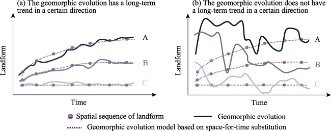
Figure 2 Functional diagram of geomorphic evolution (A, B, and C represent different landforms, respectively)

4 Two different types of space-for-time substitution in geomorphology

According to the former researches, we can find that although the definitions of space-for-time substitution in geomorphology are different, they all mentioned the inference of long-term landform development from the comparison of similar landforms of different ages or at different stages of evolution. In fact, the above concept corresponds to two different types of space-for-time substitution in geomorphology, which are defined as “space-for-time substitution in narrow sense” and “space-for-time substitution in broad sense” (Figure 3).
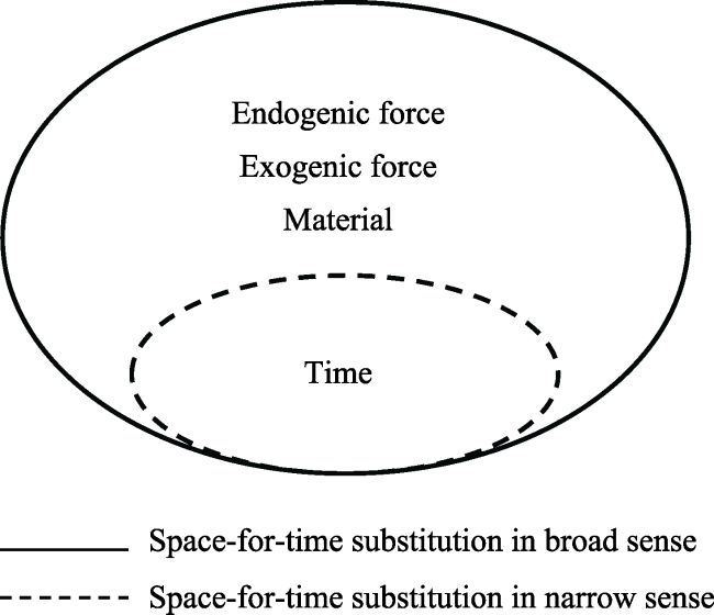
Figure 3 Schematic diagram of two different types of space-for-time substitution

4.1 Space-for-time substitution in narrow sense

Space-for-time substitution in narrow sense refers to the inference of landform development by comparing the landforms of different ages. “Different age” refers to the absolute age of landform, that is, the geological age of geomorphological formation, indicating the number of years since the formation of landform. The absolute age of landform can be determined by the geological age of sediments related to landform. Therefore, in this type of space-for-time, the dominant factor causing significant differences in landforms can only be time, while other landform forming processes are basically the same.

4.2 Space-for-time substitution in broad sense

Different from space-for-time substitution in narrow sense, in space-for-time substitution in broad sense, the long-time development of landform is inferred by comparing the landforms of different evolution stages. According to the theory of landform erosion cycle, the relative age of landform can be distinguished by different geomorphic features (Davis,1899). Therefore, in this type of space-for-time substitution, the dominant factors causing significant differences in landforms can be time, endogenic force and exogenic force, or a combination of all these factors.

5 Discussion and conclusions

5.1 Discussion

In recent years, with the advancement of earth observation technology and the enrichment of data acquisition methods, some scholars have developed a series of landscape evolution models based on space-for-time substitution in different types of landforms. However, as a research method which is just preliminarily understood, there are still many scientific problems that need to be studied and solved in the future research: (1) The mechanism of space-for-time substitution has not been systematically understood and the application conditions and influencing factors are not yet clear. It is precisely because of this, space-for-time substitution cannot become one of the basic theories of geomorphology. Therefore, the establishment of theoretical system of space-for-time substitution should be the focus of future research. (2) In former research, most of the geomorphic evolution models based on space-for-time substitution were qualitative conceptual models. Therefore, how to embed the empirical statistical model based on sample data and the system dynamics model based on the physical process in the model based on space-for-time substitution method will be another focus of future research. (3) Due to the limitation of the data, the former research of geomorphic evolution using space-for-time substitution were often based on field or laboratory work. Furthermore, the spatial scope of previous studies is often small, and thus the validation of space-for-time substitution has not been verified on a large spatial scale. In the meanwhile, the selection of landform spatial sequence at different development stages is usually only for a single landform entity, which leads to a decrease of the credibility of the model. With the enrichment of data acquisition methods, especially the establishment of global digital elevation model (DEM) of different resolution, we can observe the earth’s surface morphology with more precise vision, which also provides the data base of geomorphic research using space-for-time substitution in different areas. (4) In the application of space-for-time substitution, it is necessary to ensure that the spatial sequence of the selected landform entities is under relatively consistent landform forming processes. Former researches have paid more attention to the natural landform forming processes. In fact, as mentioned above, the impact of human activities on the landscape has been widely recognized by academics. Therefore, the future studies should consider the comprehensive effect of natural landform forming processes and human activities on the landform, so as to make the model more credible. (5) Previous studies of geomorphic evolution using space-for-time substitution have focused on reconstructing the landform of the historical period. In fact, the prediction of future geomorphic processes may be of more importance. The prediction of landform development to a certain extent may help human beings better respond to the challenges of global change. Therefore, the construction of future landform evolution trajectory should also be a key point of future research.

5.2 Conclusion

Patterns and processes have always been the focus and hotspot of geomorphologic and even geographical studies (Fu, 2014). Space-for-time substitution is an important method to study the change of a certain object in time series based on ergodicity hypothesis. It is widely used in ecology, geomorphology and other fields. As a research method, space-for-time substitution has some common characteristics in different disciplines based on the use of space as a surrogate of time and the translation of a spatial sequence into a temporal sequence of individual system evolution and change. It also has some differences in the application of space-for-time substitution to specific subjects. For example, in the study of ecology, species composition, species dominance, richness index, diversity index and evenness etc. are used as ergodic indicators to derive the spatial sequence of biotic population; instead, in the study of geomorphic evolution, distance, location, landform dimension and complexity are taken as ergodic indicators of landform development to derive the spatial sequence.
[1]
Bierman P R, Montgomery D R , 2013. Key Concepts in Geomorphology. San Francisco: WH Freeman.

[2]
Birkeland P W , 1992. Quaternary soil chronosequences in various environments-extremely arid to humid tropical. In: Developments in Earth Surface Processes. Vol. 2. Amsterdam:Elsevier, 261-281.

[3]
Boltzmann L , 1871. Einige allgemeine sätze über wärmegleichgewicht. Wiener Berichte, 63:679-711.

[4]
Brierley G J, Fryirs K A , 2005. Geomorphology and River Management: Applications of the River Styles Framework. Oxford: Blackwell.

[5]
Cao M, Tang G A, Zhang F et al., 2013. A cellular automata model for simulating the evolution of positive-negative terrains in a small loess watershed. International Journal of Geographical Information Science, 27(7):1349-1363.

[6]
Chen A, Darbon J, Morel J , 2014. Landscape evolution models: A review of their fundamental equations. Geomorphology, 219:68-86.

[7]
Cui L Z , 2002. The coupling relationship between the sediment yield from rainfall erosion and the topographic feature of the watershed [D]. Xi’an: Northwest Agriculture and Forest University. (in Chinese)

[8]
Davis W M , 1899. The geographic cycle. The Geographical Journal, 14(5):481-504.

[9]
Ely J C, Clark C D, Spagnolo M et al., 2018. Using the size and position of drumlins to understand how they grow, interact and evolve. Earth Surface Processes and Landforms, 43(5):1073-1087.

[10]
Farre J A, McGregor B A, Ryan W B F et al., 1983. Breaching the shelf break: Passage from youthful to mature phase in submarine canyon evolution. Society Economic Paleontologists and Mineralogists Special Publication, 33:25-39.

[11]
Fryirs K, Brierley G J, Erskine W D , 2012. Use of ergodic reasoning to reconstruct the historical range of variability and evolutionary trajectory of rivers. Earth Surface Processes & Landforms, 37(7):763-773.

[12]
Fu B J , 2014. The integrated studies of geography: Coupling of patterns and processes. Acta Geographica Sinica, 69(8):1052-1059. (in Chinese)

[13]
Glock W S , 1931. The development of drainage systems: A synoptic view. Geographical Review, 21(3):475-482.

[14]
Hilley G E, Arrowsmith J Ramón , 2008. Geomorphic response to uplift along the dragon’s back pressure ridge, Carrizo Plain, California. Geology, 36(5):367-370.

[15]
Huang C, Liu G H , 2010. A review of the application of cellular models in landscape evolution modeling. Progress in Geography, 24(1):105-115. (in Chinese)

[16]
Huggett R J , 1998. Soil chronosequences, soil development, and soil evolution: A critical review. Catena, 32(3/4):155-172.

[17]
Huggett R J , 2011. Fundamentals of Geomorphology. 3rd ed. London:Routledge.

[18]
Ji N, Cheng H Q, Yang Z Y et al., 2013. Sedimentary and morphological evolution of nearshore coast of Yangtze Estuary in the last 30 years. Acta Geographica Sinica, 68(7):945-954. (in Chinese)

[19]
Jin D S , 1995. Experiments and Simulations in Geomorphology. Beijing: Seismological Press. (in Chinese)

[20]
Kang Y Y, Ding X R, Cheng L G et al., 2010. Coastline changes in Yancheng since 6000 years ago based on remote sensing image dodging. Acta Geographica Sinica, 65(9):1130-1136. (in Chinese)

[21]
Kirkbride M, Matthews D , 1997. The role of fluvial and glacial erosion in landscape evolution: The Ben Ohau Range, New Zealand. Earth Surface Processes & Landforms, 22(3):317-327.

[22]
Leyland J, Darby S E , 2008. An empirical-conceptual gully evolution model for channelled sea cliffs. Geomorphology, 102(3/4):419-434.

[23]
Li S C , 2013. On Paradigms of Physical Geography. Beijing: Science Press. (in Chinese)

[24]
Li X Z, Sun Y G, ülo Mander et al., 2013. Effects of land use intensity on soil nutrient distribution after reclamation in an estuary landscape. Landscape Ecology, 28(4):699-707.

[25]
Likens G E , 1989. Long-term Studies in Ecology . New York:Springer.

[26]
Liu D S , 1985. Loess and Environment. Beijing: Science Press. (in Chinese)

[27]
Micallef A, Ribó M, Canals M et al., 2014. Space-for-time substitution and the evolution of a submarine canyon-channel system in a passive progradational margin. Geomorphology, 221(11):34-50.

[28]
Montgomery D R , 1999. Process domains and the river continuum. Journal of the American Water Resources Association, 35(2):397-410.

[29]
Obanawa H, Hayakawa Y S, Matsukura Y , 2009. Rates of slope decline, talus growth and cliff retreat along the Shomyo River in central Japan: A space-time substitution approach. Geografiska Annaler: Series A, Physical Geography, 91(4):269-278.

[30]
Paine A D M , 1985. Ergodic reasoning in geomorphology-time for a review of the term. Progress in Physical Geography, 9(1):1-15.

[31]
Parker R S , 1977. Experimental study of drainage basin evolution and its hydrologic implications [D]. Fort Collins:Colorado State University.

[32]
Pelletier J D , 2003. Drainage network evolution in the rainfall erosion facility: Dependence on initial conditions. Geomorphology, 53(1):183-196.

[33]
Piegay H, Schumm S A , 2003. Systems approaches in fluvial geomorphology. In: Tools in Fluvial Geomorphology, In: Kondolf G M, Piegay H (eds.). Fluvial Geomorphology. Chichester: John Wiley & Sons.

[34]
Schmidt K H, Meitz P , 2000. Effects of Increasing Humidity on Slope Morphology, Studied on Cuesta Scarps on the Colorado Plateau, USA. IAHS Publications, 261:165-181.

[35]
Schumm S A , 1991. To Interpret the Earth: Ten Ways to be Wrong. Cambridge: Cambridge University Press.

[36]
Schumm S A, Lichty R W , 1965. Time, space, and causality in geomorphology. American Journal of Science, 263(2):110-119.

[37]
Schumm S A, Mosley M P, Weaver W E , 1987. Experimental Fluvial Geomorphology. New York: John Wiley & Sons.

[38]
Simon A, Hupp C R , 1986. Channel evolution in modified Tennessee channels. Proceedings of the Fourth Federal Interagency Sedimentation Conference. US Government Printing Office, Washington D.C., 71-82.

[39]
Song C Q , 2016. On paradigms of geographical research. Progress in Geography, 35(1):1-3. (in Chinese)

[40]
Stolar D B, Willett S D, Montgomery D R , 2007. Characterization of topographic steady state in Taiwan. Earth and Planetary Science Letters, 261(3/4):421-431.

[41]
Thornes J B, Brunsden D , 1977. Geomorphology and Time. London: Methuen.

[42]
Tucker G E, Hancock G R , 2010. Modelling landscape evolution. Earth Surface Processes & Landforms, 35(1):28-50.

[43]
Twichell D C, Roberts D G , 1982. Morphology, distribution, and development of submarine canyons on the United States Atlantic continental slope between Hudson arid Baltimore Canyons. Geology, 10(8):408-412.

[44]
Walker P H, Coventry R J , 1976. Soil profile development in some alluvial deposits of eastern New South Wales. Australian Journal of Soil Research, 14(3):305-317.

[45]
Waters C N , 2016. The Anthropocene is functionally and stratigraphically distinct from the Holocene. Science, 6269(351):137-147.

[46]
Willett S D, Mccoy S W, Perron J T et al., 2014. Dynamic reorganization of river basins. Science, 343(6175):1248765.

[47]
Willgoose G, Bras R L, Rodriguez-Iturbe I , 1991. Results from a new model of river basin evolution. Earth Surface Processes and Landforms, 16(3):237-254.

[48]
Xin Z B, Xie Z R , 2006. Construction of the simulating model for geomorphic evolution on the Yangtze delta, China. Acta Geographica Sinica, 61(5):549-560. (in Chinese)

[49]
Xiong L Y, Tang G A, Li F Y et al., 2014. Modeling the evolution of loess-covered landforms in the Loess Plateau of China using a DEM of underground bedrock surface. Geomorphology, 209(3):18-26.

[50]
Yan Y C, Zhang S W, Li X Y , 2005. Temporal and spatial variation of erosion gullies in kebai black soil region of Heilongjiang during the past 50 years. Acta Geographica Sinica, 60(6):1015-1020. (in Chinese)

[51]
Yang R, Willett S D, Goren L , 2015. In situ low-relief landscape formation as a result of river network disruption. Nature, 520(7548):526.

[52]
Yuan B Y, Ba T E, Cui J X et al., 1987. The relationship between gully development and climatic changes in the loess Yuan region: Examples from Luochuan, Shaanxi Province. Acta Geographica Sinica, 54(4):42-51. (in Chinese)

[53]
Zhang J Y, Chen L, Wang Z G et al., 2006. Investigation on valid duration of natural river model. Journal of Hydraulic Engineering, 37(3):365-370. (in Chinese)

[54]
Zhang J Y, Chen L, Wu M W et al., 2006. Phenomena of replacement between spatial and temporal processes during the process of reformation downstream reservoirs: A case study of middle-lower Han river after the construction of Danjiangkou Reservoir. Advances in Water Science, 17(3):348-353. (in Chinese)

[55]
Zhang O Y, Jin D S, Chen H , 2000. An experimental study on spatial and temporal processes and complex response of river channel evolution. Geographical Research, 19(2):180-188. (in Chinese)

[56]
Zhang W, Fu Y J, Liu B B et al., 2015. Geomorphological process of late Quaternary glaciers in Kanas river valley of the Altay Mountains. Acta Geographica Sinica, 70(5):739-750. (in Chinese)

[57]
Zhu L H, Wu J Z, Hu R J et al., 2009. Geomorphological evolution of the Liaohe river delta in recent 20 years. Acta Geographica Sinica, 64(3):357-367. (in Chinese)

Outlines

/