
Journal of Geographical Sciences >
Functional zoning and space management of Three-River-Source National Park
|
Fu Mengdi (1987–), specialized in national park assessment and planning. E-mail: mengdi_fu@163.com |
Received date: 2018-09-12
Accepted date: 2019-03-10
Online published: 2019-12-06
Supported by
National Key Research and Development Program of China, No(2017YFC0503806)
Copyright
Functional zoning is a key step for the integrated planning and scientific management of a national park. Selecting the Three-River-Source National Park (TNP) as the study area, this paper establishes an evaluation system including 13 evaluation indexes which are classified into four categories, namely: ecosystem services; potential distribution of key species habitats; ecological sensitivity; and ecological resilience through the comprehensive analysis on the regional eco-environmental features in the study area. The results of the comprehensive analysis, combined with the functions and requirements of management of national parks, indicate that TNP is divided into the first-level zone (the core conservation area, the ecological restoration area and the traditional utilization area) with definite targets of space management and the second-level zone with implementation of control measures. This method of functional zoning lays a solid foundation for the scientific planning of TNP; moreover, our study provides new insights into other national parks’ functional zoning.
FU Mengdi , TIAN Junliang , REN Yueheng , LI Junsheng , LIU Weiwei , ZHU Yanpeng . Functional zoning and space management of Three-River-Source National Park[J]. Journal of Geographical Sciences, 2019 , 29(12) : 2069 -2084 . DOI: 10.1007/s11442-019-1705-z
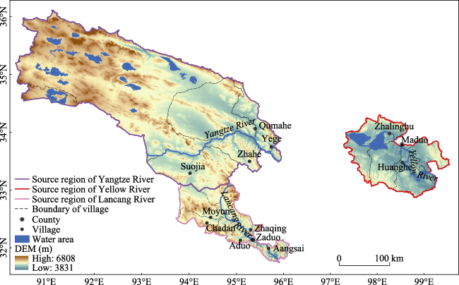
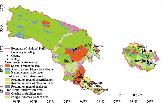
Figure 1 Location of the Three-River-Source National Park, China |
Table 1 Evaluation index system and classification for functional zoning of the Three-River-Source National Park |
| Category | Weight | Indicator | Weight | Unit | Classification assignment | Methods and sources | |||
|---|---|---|---|---|---|---|---|---|---|
| 1 | 2 | 3 | 4 | ||||||
| Ecosystem services | 0.35 | Quantity of water conservation | 0.51 | mm | <200 | 200-300 | 300-400 | >400 | InVEST model; Lai et al., 2013 |
| Quantity of soil conservation | 0.31 | t/ha | 0-100 | 100-200 | 200-400 | >400 | USLE; Lai et al., 2013 | ||
| Quantity of carbon sequestration | 0.18 | gC/m2 | <50 | 50-100 | 100-200 | >200 | Photosynthesis equation; Lai et al., 2013 | ||
| Ecological sensitivity | 0.2 | Vegetation coverage | 0.36 | % | <5 | 5-10 | 10-20 | >20 | NDVI; Wei et al., 2015 |
| Buffer zone of rivers and lakes | 0.29 | m | >100 | 100-50 | 50-1 | <1 | Wei et al., 2015 | ||
| Elevation | 0.18 | m | 3500-4000 | 4000-4500 | 4500-5000 | 5000-7000 | DEM; Weiet al., 2015 | ||
| Soil erosion intensity | 0.17 | — | <2500 | 2500-5000 | 5000-8000 | >8000 | MWRC, 2008 | ||
| Ecological resilience | 0.15 | Net primary productivity of vegetation | 0.50 | g/m2 | <200 | 200-400 | 400-800 | >800 | NPP model; Zhou et al., 1998 |
| Soil organic matter | 0.50 | % | <1 | 1-3 | 3-5 | >5 | National soil spatial attribute data | ||
| Potential distribution of key species habitats | 0.3 | Potential distribution of carnivores | 0.33 | — | 0 | — | — | 1 | MaxEnt model; Hirzel et al., 2006; Qi et al., 2011 |
| Potential distribution of ungulates | 0.27 | — | 0 | — | — | 1 | |||
| Potential distribution of birds | 0.24 | — | 0 | — | — | 1 | |||
| Potential distribution of fishes | 0.16 | — | 0 | — | — | 1 | |||
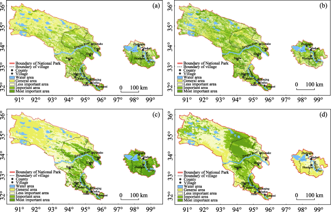
Figure 2 The spatial distribution of each category of indexes in the Three-River-Source National Park(a. Ecosystem services; b. Ecological sensitivity; c. Ecological resilience; d. Potential habitats of key species) |
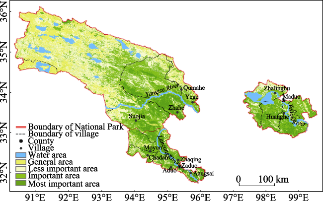
Figure 3 Comprehensive assessment of the Three-River-Source National Park |
Table 2 Functional zoning of the Three-River-Source National Park |
| Region | Area (km2) | First-level zone | Area (km2) | Second-level zone | Area (km2) |
|---|---|---|---|---|---|
| Source Region of the Yangtze River | 90321.49 | Core conservation area | 75546.27 | Special protection area | 8142.56 |
| Area of rivers, lakes and wetlands | 4060.50 | ||||
| Natural conservation area | 63343.21 | ||||
| Ecological restoration area | 1504.76 | Restoration area of desertification | 261.82 | ||
| Restoration area of black soil land | 104.76 | ||||
| Restoration area of enclosure | 1138.18 | ||||
| Traditional utilization area | 13270.46 | Grazing prohibition area | 5219.24 | ||
| Forage-livestock balance area | 8051.22 | ||||
| Regulatory area of construction land | — | ||||
| Source Region of the Yellow River | 19083.13 | Core conservation area | 8602.87 | Special protection area | 1173.30 |
| Area of rivers, lakes and wetlands | 1075.53 | ||||
| Natural conservation area | 6354.05 | ||||
| Ecological restoration area | 2445.43 | Restoration area of desertification | 484.47 | ||
| Restoration area of black soil land | 25.98 | ||||
| Restoration area of enclosure | 1934.98 | ||||
| Traditional utilization area | 8034.82 | Grazing prohibition area | 2043.57 | ||
| Forage-livestock balance area | 5991.26 | ||||
| Regulatory area of construction land | — | ||||
| Source Region of the Lancang River | 13736.19 | Core conservation area | 6357.58 | Special protection area | 4376.47 |
| Natural conservation area | 1981.11 | ||||
| Ecological restoration area | 2000.14 | Restoration area of desertification | 35.46 | ||
| Restoration area of black soil land | 83.22 | ||||
| Restoration area of enclosure | 1881.46 | ||||
| Traditional utilization area | 5378.47 | Grazing prohibition area | 1611.99 | ||
| Forage-livestock balance area | 3766.48 | ||||
| Regulatory area of construction land | — |
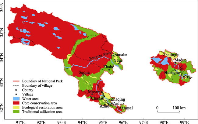
Figure 4 The first-level functional zoning of the Three-River-Source National Park |
Figure 5 The second-level functional zoning of the Three-River-Source National Park |
Table 3 Space management of the Three-River-Source National Park |
| Region | First-level zone | Management targets | Second-level zone | Management measures |
|---|---|---|---|---|
| Source Region of the Yangtze River | Core conservation area | 1. Protecting the original alpine marshes, alpine meadows, alpine grasslands and desert ecosystem, and improving water conservation; 2. Protecting the rare species and restoring the populations of rare wildlife, and protecting the integrity of key habitats; 3. Protecting the authenticity of the original landscape of plateaus, marshes, lakes and rivers network; 4. Protecting the glaciers and snow mountains and the unique ice erosion landscape, and protecting the regional solid water source. | Special protection area | Human activities, except scientific research and monitoring work, should be forbidden; the monitoring of wildlife and its habitat should be strengthened, and regular evaluation should be carried out; and an effective compensating protection system for wildlife should be developed. |
| Rivers, lakes and wetlands areas | The rivers, lakes and wetlands should be closed for conservation; the grazing and construction projects should be forbidden; the river chief and lake chief should be appointed and the office for river chief or lake chief should be set up to ensure the health of the ecosystem of rivers, lakes and wetlands. | |||
| Natural conservation area | The grazing should be forbidden; in addition to the necessary roads for patrols, other roads should not be built; other construction projects should be prohibited; the measure of enclosure for protection should be taken; for sites without ecological experience, scientific researches and environmental education activities could be carried out at the monitoring sites of eco-environment. | |||
| Ecological restoration area | 1. Maintaining the health and stability of the alpine ecosystem, and improve water conservation; 2. Protecting the rare species and the integrity of the migratory corridor of wild birds and animals, and forming a protective buffer zone between the ecosystem and the traffic energy corridor; 3. Accelerating the restoration of degraded grassland based on natural restoration and necessary human intervention. | Desertification restoration areas | The grazing and construction projects are prohibited; the immobile sandy land covered with vegetation should be closed for protection combined with biological measures against the desertification; for the semi-mobile and mobile sandy lands without vegetation, the mechanical sand-control barriers which could promote the growth of plants should be set up and grass should be planted to form a sand-control system based on plants. | |
| Black soil land restoration areas | The grazing and construction projects should be prohibited; engineering restoration measures combined with the biological and natural restoration measures should be taken for the black soil land; prevention and control of rodent damage in grassland should be strengthened. | |||
| Enclosure restoration areas | Grazing and construction projects should be prohibited; the measures such as returning grazing land to grassland, reclaiming grassland, human restoration and replanting should be studied for the degraded grassland; the activities of ecological experience and environmental education should be developed reasonably. | |||
| Traditional utilization area | 1. Maintaining the balance between the forage and livestock, and coordinating the population and environment carrying capacity; 2. Organizing the ecological experience activities reasonably, which is important to the ecological culture exhibition and environmental education; 3. Developing the ecological industry reasonably, and promoting the harmonious development of the community. | Grazing prohibition area | The grazing should be prohibited by stages; the mowing and other human activities that would damage the grasslands should be prohibited; the development and construction projects which are not consistent with the management objectives should be prohibited; the degraded grasslands should be restored through natural restoration and human restoration. | |
| Forage-livestock balance area | The forage-livestock balance should be maintained and the seasonal grazing system and rotational grazing system should be established; the ecological organic animal husbandry should be developed moderately; the development and construction projects that are inconsistent with management objectives should be prohibited; the routes and areas for ecological experience activities should be limited and the visitor volume should be controlled. |
Table 3 (Continued 1) Space management of the Three-River-Source National Park |
| Region | First-level zone | Management targets | Second-level zone | Management measures |
|---|---|---|---|---|
| Construction regulatory area | The land use for urban and rural construction projects should be under strict management, and the scale and layout of land for urban and rural construction should be controlled; the roads should be strictly planned and built, and the animal corridors should be set for ecological restoration; franchising is allowed such as catering and entertainment services. | |||
| Source Region of the Yellow River | Core conservation area | 1. Maintaining the health and stability of alpine ecosystem; 2. Protecting the authenticity and integrity of the natural landscape of plateau lakes. 3. Strengthening the monitoring and regular evaluation of wildlife and its habitats, and developing an effective compensating protection system for wildlife. | Special protection area | Human activities except the scientific research and monitoring work should be forbidden; monitoring of wildlife and its habitat should be strengthened, and regular evaluation should be carried out. |
| Rivers, lakes and wetlands areas | The rivers, lakes and wetlands should be closed for conservation; the grazing and construction projects should be forbidden; the river chief and lake chief should be appointed and the office for river chief or lake chief should be set up to ensure the health of the ecosystems of rivers, lakes and wetlands; fishing should be prohibited in the long term. | |||
| Natural conservation area | Grazing should be forbidden; in addition to the necessary roads for patrol, other roads should not be built; other construction projects should be prohibited; the measures of enclosure for conservation should be studied; for sites without the ecological experience, scientific researches and environmental education activities could be carried out at the monitoring sites of eco-environment. | |||
| Ecological restoration area | 1. Accelerating the restoration of degraded grassland based on the natural restoration, and combination of necessary manual intervention. 2. Improving the water conservation and biodiversity. | Desertification restoration areas | Grazing and construction projects should be prohibited; immobile sandy land covered with vegetation should be closed for conservation and biological measures against desertification should be taken; for semi-mobile and mobile sandy lands without vegetation, mechanical sand-control barriers which could promote the growth of plants should be set up and grass should be planted to form a sand-control system based on plants. | |
| Black soil land restoration areas | Grazing and construction projects should be prohibited; engineering restoration measures combined with biological and natural restoration measures should be studied for the black soil lands; prevention and control of rodent damage in grassland should be strengthened. | |||
| Enclosure restoration area | Grazing and construction projects should be prohibited; measures such as returning grazing land to grassland, reclaiming grassland, human restoration and replanting should be studied for the degraded grassland; the activities of ecological experience and environmental education should be developed reasonably. |
Table 3 (Continued 2) Space management of the Three-River-Source National Park |
| Region | First-level zone | Management targets | Second-level zone | Management measures |
|---|---|---|---|---|
| Source Region of the Yellow River | Traditional utilization area | 1. Maintaining the balance between the forage and livestock, and coordinating the population and environment carrying capacity. 2. Developing the activities of ecological experience reasonably, which is important to the ecological culture exhibition and environmental education. 3. Developing the ecological industry reasonably, and promoting the harmonious development of the community. | Grazing prohibition area | Grazing should be prohibited by stages; the mowing and other human activities that would damage the grassland should be prohibited; the development and construction projects which are not consistent with the management objectives should be prohibited; and the degraded grassland should be restored through natural restoration combining with human restoration. |
| Forage-livestock balance area | The forage-livestock balance should be maintained and the seasonal grazing system and rotational grazing system should be established; the ecological organic animal husbandry should be developed moderately; the development and construction projects that are inconsistent with management objectives should be prohibited; the routes and areas for ecological experience activities should be limited and the visitor volume controlled. | |||
| Construction regulatory area | The land use for urban and rural construction projects should be under strict management, and the scale and layout of urban and rural construction controlled; the roads should be strictly planned and built, and the animal corridors should be set for the ecological restoration; franchising is allowed such as catering and entertainment services. | |||
| Core conservation area | 1. Maintaining the health and stability of alpine ecosystem, and improving the water conservation and biodiversity; 2. Strengthening the monitoring of wildlife, further alleviating the disturbance of human activities and protecting the integrity of wildlife’s habitats. | Special protection area | Human activities, except for scientific research and monitoring work, should be forbidden; the monitoring of wildlife and its habitat should be strengthened, and regular evaluation carried out; in addition, an effective comprehensive protection system for wildlife needs to be developed. | |
| Rivers, lakes and wetlands areas | The area of glaciers and snow mountains and alpine marshes should be closed for conservation; the grazing and construction projects should be forbidden; the river chief and lake chief should be appointed and the office for river chief or lake chief should be set up to ensure the health of the ecosystems of rivers, lakes and wetlands; the fishing should be prohibited in the long term. | |||
| Natural conservation areas | Grazing should be forbidden; in addition to the necessary roads for patrol, other roads should not be built; other construction projects should be prohibited; the measures of enclosure for conservation should be studied; for sites without the ecological experience, scientific research and environmental education activities could be carried out at the monitoring sites of eco-environment. | |||
| Ecological restoration area | 1. Maintaining the health and stability of alpine ecosystem, and improving the water conservation; 2. Protecting the wildlife and the integrity of wildlife’s habitats; 3. Accelerating the restoration of degraded grassland and alleviating the water and soil erosion based on the natural restoration and necessary manual intervention. | Sandy land restoration areas | Grazing and construction projects should be prohibited; the immobile sandy land that is covered with vegetation should be closed for conservation study and combined with the biological measures against desertification; for the semi-mobile and mobile sandy lands without vegetation, the mechanical sand-control barriers which could promote the growth of plants should be set up and the grass planted to form a sand-control system based on plants. | |
| Black soil land restoration areas | Grazing and construction projects should be prohibited; the engineering restoration measures combined with the biological and natural restoration measures studied for the black soil land; prevention and control of rodent damage in grassland strengthened. | |||
| Enclosure restoration areas | Grazing and construction projects should be prohibited; the measures such as returning grazing land to grassland, reclaiming grassland, human restoration and replanting should be studied for the degraded grassland. |
Table 3 (Continued 3) Space management of the Three-River-Source National Park |
| Region | First-level zone | Management targets | Second- level zone | Management measures |
|---|---|---|---|---|
| Source Region of the Lancang River | Traditional utilization area | 1. Maintaining the balance between the forage and livestock, and coordinating the population and environment carrying capacity. 2. Developing the activities of ecological experience reasonably, which is important to the ecological culture exhibition and environmental education. 3. Innovating the plateau ecological animal husbandry, and promoting the harmonious development of the community. | Grazing prohibition areas | Grazing should be prohibited by stages; the mowing and other human activities that would damage the grassland should be prohibited; the development and construction projects which are not consistent with the management objectives should be prohibited; the degraded grassland should be restored through natural restoration and human restoration. |
| Forage- livestock balance area | The forage-livestock balance should be maintained and the seasonal grazing system and rotational grazing system should be established; the ecological organic animal husbandry should be developed moderately; the development and construction projects that are inconsistent with management objectives should be prohibited; the routes and areas for ecological experience activities should be limited and the visitor volume should be controlled. | |||
| Construction regulatory areas | The land use for urban and rural construction projects should be under strict management, and the scale and layout of urban and rural construction controlled; the roads should be strictly planned and built, and animal corridors should be set for ecological restoration;franchising is allowed such as catering and entertainment services. |
Notes: The river/lake chiefs are the first responsible persons for river/lake management and protection. |
| 1 |
|
| 2 |
|
| 3 |
|
| 4 |
|
| 5 |
|
| 6 |
|
| 7 |
|
| 8 |
|
| 9 |
|
| 10 |
|
| 11 |
|
| 12 |
|
| 13 |
|
| 14 |
|
| 15 |
|
| 16 |
|
| 17 |
|
| 18 |
Ministry of Water Resources of the People’s Republic of China(MWRC), 2008. Standards for Classification and Gradation of Soil Erosion SL 190-2007. Beijing: China Water Power Press, 3-12. (in Chinese)
|
| 19 |
|
| 20 |
|
| 21 |
National Park Service(NPS), 2009. General Management Planning Dynamic Sourcebook. Retrieved from https://parkplanning.nps.gov/files/GMPSourcebook/GMPSourcebook_Dec2009ver2.2.pdf .
|
| 22 |
|
| 23 |
|
| 24 |
|
| 25 |
|
| 26 |
|
| 27 |
|
| 28 |
|
| 29 |
|
| 30 |
|
| 31 |
|
| 32 |
|
/
| 〈 |
|
〉 |