Land engineering and its role for sustainable agriculture in the agro-pastoral ecotone: A case study of Yulin, Shaanxi Province, China

  • WU Wenhao , 1 ,
  • CHEN Zongfeng 1 ,
  • LI Yuheng , 2, * ,
  • WANG Yongsheng 2 ,
  • YAN Jiayu 2, 3 ,
  • SONG Chuanyao 2, 3
Expand
  • 1. Faculty of Geographical Science, Beijing Normal University, Beijing 100875, China
  • 2. Institute of Geographic Sciences and Natural Resources Research, CAS, Beijing 100101, China
  • 3. University of Chinese Academy of Sciences, Beijing 100049, China
*Corresponding author: Li Yuheng (1983-), PhD and Associate Professor, E-mail:

Author: Wu Wenhao (1992-), PhD Candidate, E-mail:

Received date: 2018-07-23

  Accepted date: 2018-12-15

  Online published: 2019-04-19

Supported by

National Key Research and Development Program of China, No.2017YFC0504705

National Natural Science Foundation of China, No.41771191, No.41471143

Copyright

Journal of Geographical Sciences, All Rights Reserved

Abstract

With global climate change, the agricultural light-temperature potential productivity in the agro-pastoral ecotone has increased. This offers a good opportunity to develop agriculture in the agro-pastoral ecotone. However, the agro-pastoral ecotone is also an ecologically fragile area in which land degradation challenges agricultural development. As population grows and the need for food increases, the land carrying capacity of the agro-pastoral ecotone becomes insufficient, and the human-land relationship is not harmonious. Such conditions have limited the agricultural and rural development in the ecotone. The paper demonstrates how land engineering may improve land quality and support agricultural development in the ecotone based on studies at a research station established in 2015 in Yulin, Shaanxi Province, China. The studies target three factors: soil improvement, crop selection, and field management. The results show that: (1) The highest yield of crops planted on improved land is close to or even higher than that achieved under previous crop growth conditions. For instance, the corn yields can exceed 25%. (2) The potatoes grown on the improved land yield the highest gross income, reaching 67,200 yuan/ha. By way of land engineering, input costs can be balanced in 3-5 years. (3) As a result of land engineering, some villages in Yulin City have realized sustainable agricultural and even rural development, and promotion of this model will support the sustainable development of agriculture in the agro-pastoral ecotone.

Cite this article

WU Wenhao , CHEN Zongfeng , LI Yuheng , WANG Yongsheng , YAN Jiayu , SONG Chuanyao . Land engineering and its role for sustainable agriculture in the agro-pastoral ecotone: A case study of Yulin, Shaanxi Province, China[J]. Journal of Geographical Sciences, 2019 , 29(5) : 818 -830 . DOI: 10.1007/s11442-019-1630-1

1 Introduction

Global food security is one of the great challenges of our time, as we seek to accommodate not only a growing world population, but also a more affluent society that is more demanding in its requirements for a secure and consistent supply of safe and high-quality food. Efforts to introduce more technocratic solutions for global food security, for example, include the use of genetically modified organisms and the intensification of agricultural production to enhance grain production throughout the world. Recently, the importance of land engineering, which consolidates degraded land and improves soil conditions, has started to assume importance (Li et al., 2018).
In China, the agro-pastoral ecotone widely exists in the north, northwest, and southwest parts of the country. These places have long been facing severe ecological problems such as land degradation and water shortages. Desertification, which is considered one of the most serious challenges in the agro-pastoral ecotone, covers an area of 72.5 × 10⁴ km2 (Liu et al., 2018a). Owing to global climate change, the gravitational center of China’s grain production has moved northward, and the agricultural light-temperature potential productivity has increased in the agro-pastoral ecotone, which is expected to become one of the key granaries for North China (Liu et al., 2009; Liu et al., 2018b). However, the expanded grain production has aggravated the contradictions between natural resources, such as, land and water, and the local rural economy in the agro-pastoral ecotone.
To date many researchers have undertaken agricultural research in the agro-pastoral ecotone in areas such as the formation mechanism of the degraded land (Huang et al., 2007), the status of degraded land (Liu and Gao, 2002), land use/cover change (LUCC) and its response (Zhao et al., 2017), land carrying capacity and ecosystem services (Wang et al., 1999; Jia et al., 2014). Since 1999, the Grain for Green Project has been implemented in the agro-pastoral zone. Then, the Grazing Ban Policy was put into practice and this policy has played an important role in ensuring the ecological security of the region. Nevertheless, these kinds of policies have limited impact on local rural development. To improve agricultural production, the state has introduced relevant policies to adjust the agricultural production structure in the agro-pastoral zone, providing new ideas for agricultural and rural development in this area. These studies and policies have highlighted the status quo and constraints to agricultural and rural development in the agro-pastoral ecotone, and also provided scientific support for carrying out land engineering as a cooperative approach to improving local land conditions in the ecotone.
The concept of land engineering has become popular in recent years. Land engineering is a kind of comprehensive technology which includes investigation, evaluation, planning, design, development, remediation, and protection of land resources and its integrated application. It is an interdisciplinary subject combining land resources science with engineering technology (Liu, 2015). The implementation of land policy measures requires the adoption of specific technologies and methods, and land engineering is such a technology and method. Land engineering aims to promote the harmonious development of the human-land relationship and uses engineering methods to solve land problems. The goal of land engineering is to improve land quality and optimize land use structure by way of management, engineering, and other means to maximize land output benefits such as by converting unused land into usable land, and low-quality land into high-quality land (Han and Zhang, 2014). In essence, the imbalance between humans and land in the agro-pastoral ecotone is due to the mismatch between related elements, e.g. the light and temperature resources are not coordinated with the water and soil resources. Land engineering takes the various elements of the land as the main objects, and through engineering measures supplements the insufficient elements or improves the interrelationships between the various elements, thereby regulating the water and soil relationship and promoting farmland ecological engineering and rural system engineering (Liu et al., 2016). The ultimate purpose is to harmonize the human-land relationship and urban-rural relationship. So far, land engineering has already proved its role in gully land consolidation in the Loess Plateau (Li et al., 2016; Liu and Li, 2017b), and in hillside ecological land improvement in the Taihang mountain region (Zhou et al., 2018), and comprehensive improvement of “hollow” villages in agricultural areas (Chen et al., 2010). Land engineering has gradually become a powerful way to breakdown regional resource constraints and promote agriculture and rural development.
How does land engineering work in the agro-pastoral ecotone? What are the benefits of consolidating the degraded land? This paper aims to introduce the practices of land engineering which have been performed in Yulin City, Shaanxi Province, and to measure the socioeconomic and ecological benefits and the feasibility of using land engineering to transform degraded land in an agro-pastoral zone. The paper also discusses the main modes and positive significances of land engineering to coordinate the human-land relationship and promote rural development in the agro-pastoral zone.

2 Introduction to the Yulin Research Station

The research station for optimization engineering of modern agriculture was established in 2015 and is located in the northern part of Yulin, Shaanxi Province, China. Yulin City is located in the agro-pastoral ecotone of North China (Figure 1). The research station covers an area of 0.8 hectare.
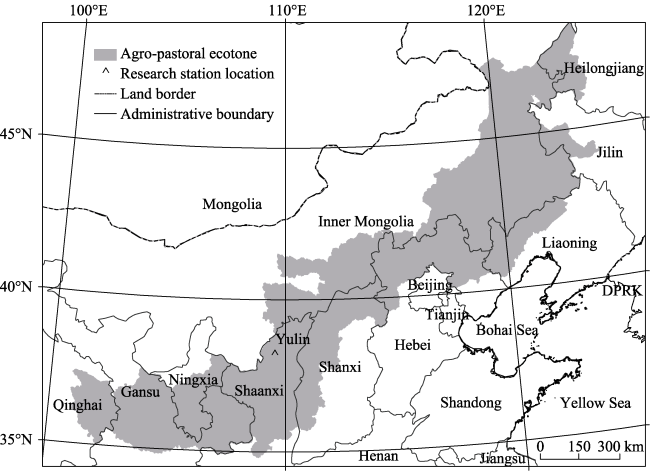
Figure 1 Location of the research station and agro-pastoral ecotones
The location of the station is the Mu Us Sandy Land which has been seriously eroded and degraded by wind and water shortages over the past decades. As a result, grain production in this area is difficult due to the challenging natural conditions. Beside the sandy land, under the Quaternary loess-paleosol sequence of northern China, a layer of red clay was formed in the Late Tertiary, which covers the entire Loess Plateau. The thickness of the red clay is around 50-70 meters (Sun et al., 2001). The parent material of the red clay is the Tertiary red clay. After the loess layer was destroyed by soil erosion, the clay layer became exposed to the surface. Red clay has a sticky texture and poor air permeability. When exposed to the elements, the surface is prone to cracking. The red clay has the same particle size as that of the loess. It has no collapsibility compared with the loess and is the main raw material for making bricks. Loess is a yellow powdery soil with a columnar joint which formed under dry climatic conditions, and collapses within 1 to 2 minutes on water contact (Shi and Shao, 2000). Red clay, loess, and sand continue to be re-distributed in the northern part of Yulin, the material being supplied for the improvement of the sandy land. Given the relatively short distances involved, the transportation costs are low.
Interdisciplinary research on land engineering and modern agriculture generally concerns experiments on soil improvement, crop selection, and field management. In brief, the aims of the studies are to explore differences in soil structure and ploughing improvements, differences in growth and suitability and input-output benefits of land consolidation under different compound types and compound ratios.
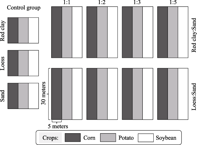
Figure 2 Illustration of experimental cells

2.1 Soil improvement

The soil improvement studied in the experiment includes two aspects. The first is to explore the improvement in crop growth and soil nutrients for different types of land, generally red clay-sand and loess-sand. The composition of the red clay developed in the Tertiary mainly consists of clay, which has water retention and fertilizer retention characteristics, poor air permeability, and easy agglomeration. The loess widely distributed around the research station is mainly composed of silt particles, which are collapsible and prone to soil erosion (Sun et al., 2013). Sandy land is not suitable for agricultural production given its poor water retention and fertilizer retention qualities. This experiment seeks to exploit the physical complementarity of the soil particle size to mix and recombine with clay, silt, and sand to solve the problems of the sandy land. The second is to explore the improvement of crop growth and soil nutrients in different compounding ratios (e.g., ratios of 1:1, 1:2, 1:3, and 1:5) under the same compound type. Pure red clay, pure loess, and pure sandy land blocks were used as controls.
The thickness of the improved soil, which we prepared as a cultivated layer, was 30 cm. Taking the ratio of 1:1 as an example, the red clay of 25-30 cm thickness was first laid on the bottom layer, with the large red clay block needing to be pulverized to small pieces of 5 cm or less. The original sandy soil with a thickness of 15 cm was then covered on the red clay. Finally, the improved soil mixture needed to be turned over (30 cm deep) to allow the red clay to mix well with the sand.

2.2 Crop selection

Different crops require different growth environments and have different adaptations to the soil, water, nutrients, and management measures. Therefore, how to match a crop’s environmental requirements with the improved land’s growing environment supply is the key to achieving stable and efficient production in agriculture in consolidated land. In this study, corn, potato, and soybean, which are planted on a large scale in this area, were selected for study. Through observation, monitoring, and comparison, the growth, yield, and economic output of the different crops under different compounding types and compounding ratios were evaluated. Finally, the best soil mix type for different crops could be decided.

2.3 Field management

The annual precipitation in the agro-pastoral ecotone is typically around 400 mm. Water resources are the main factor restricting the land use in the agro-pastoral ecotone. To guarantee the feasibility and scalability of the experiments, it is necessary to explore a set of large-scale planting and management methods after land consolidation. These include fertilization methods, irrigation methods, and monitoring modes. Therefore, at the research station, we use a precise water and fertilizer integrated system to quantitatively control irrigation and fertilization, and carry out water-saving and fertilizer-saving tests according to the crop variety in question. The test results help to promote the practice of land engineering and facilitate sustainable land use and modern agriculture in the agro-pastoral ecotone.
The use of chemical fertilizer (purified amount) per unit area in Yulin has reached 0.20 tons/ha (YBS, 2017). In our experiments, fertilizer was used in a timely manner and properly according to the properties and soil monitoring data to minimize the loss of nutrients. At the same time, organic fertilizer (chicken manure) was substituted for part of the fertilizer to reduce the amount of fertilizer used. In detail, before planting, diammonium phosphate ((NH4)2HPO4) was applied once, and the amount was 0.050 kg/ha. During the growing period, urea (CO(NH2)2) was applied twice as needed, the amount being 0.015 kg/ha on each occasion. The total amount of chemical fertilizer used was 0.07 tons/ha each year which is far lower than the average amount used in Yulin. In addition, we adopted the precision water and fertilizer integrated system and drip irrigation facilities to minimize evaporation and waste of water to a certain extent. Compared with ordinary field irrigation, the water saving is over 15%. To avoid mutual interference between adjacent experimental cells, a dedicated water and fertilizer program was implemented for each experimental cell.

3 Evaluation of feasibility and benefits of land engineering

Yulin is a typical city in the agro-pastoral ecotone at the junction of the Loess Plateau and the Mu Us Sandy Land. It is characterized by an ecological fragility, the interlacing of agriculture and animal husbandry, and an uncoordinated relationship between the people and land. Taking 2016 as an example, the total land area of Yulin City was 42,921.1 km2, of which the cultivated land area was 10,465 km2, the sandy land area was over 14,000 km2, the per capita cultivated area was 0.274 ha, and the grain output per unit of cultivated land was 3284 kg/ha. The agricultural output value of the city reached 28.2 billion yuan, and the agricultural output value per unit of cultivated land area was 26,946 yuan/ha. In sum, Yulin has a large scale of agricultural production and cultivated land. However, Yulin currently has problems relating to poor quality of cultivated land, low agricultural output value, and a relatively low income for the workers (Figure 3).
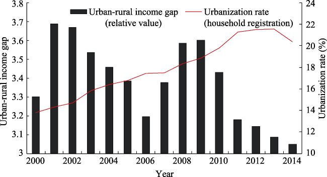
Figure 3 Urban and rural income gap in Yulin City
In terms of industrial structure, from 2000 to 2015, the proportion of primary, secondary, and tertiary industries in Yulin changed from 13.3/44.4/42.3 to 5.8/61.1/33.1, respectively (Figure 4). The primary industry mainly refers to agriculture, the secondary industry mainly includes industry and construction, and the tertiary industry includes other industries, including transportation and service industries. The proportion of employees in the three types of industries changed from 63.0/11.8/25.2 in 2000 to 47.4/28.4/24.2 in 2015 (Figure 5). Although the output value of the primary industry in Yulin is not high, the number of employees in this sector is still the highest. As of 2015, more than 50% of rural workers are mainly engaged in agricultural production (Figure 6), and agriculture is still the key to local rural development.
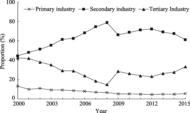
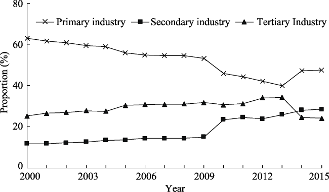
Figure 4 Evolution of industrial structure in Yulin City, 2000-2015
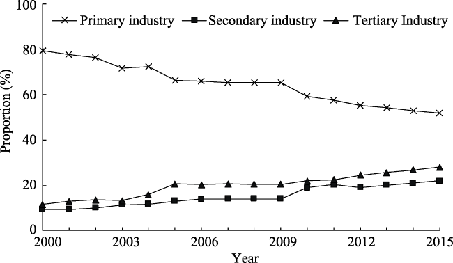
Figure 5 Evolution of employees in the three types of industries in Yulin City, 2000-2015
Figure 6 Evolution of employees in the three industries in terms of rural labor in Yulin City, 2000-2015
Along with an increase in the proportion of rural non-agricultural employment, the proportion of rural arable land that has been left idle has increased. In the period 2011-2015,the proportion of rural non-agricultural employment in Yulin increased from 42.64% to 48.24% while the multiple-crop index decreased from 98.04% to 73.79%. The traditional extensive agricultural management has caused serious problems of resources waste and low efficiency in local agriculture. Therefore, by using engineering techniques to improve the quality of cultivated land, and applying modern agricultural management techniques to improve the scale benefits of cultivated land and to increase the efficiency of agricultural output, new direction for Yulin’s agricultural development is engineering in the coming years.

3.1 Crop yields and economic benefits

Through the field planting experiments, stable crop yields were obtained after the two-year study as shown in Table 1.
Table 1 Comparison of crop yields and economic benefits between normal conditions and the present study for Yulin City in 2017
Crop types Planting area Yield (ton/ha) Unit price (yuan/kg) Gross income (yuan/ha)
Corn Experiment 12.00-14.25 1.40 16800-19950
Normal 11.25 15750
Potato Experiment 25.50-42.00 1.40-1.60 35700-67200
Normal 36.00 50400-57600
Soybean Experiment 3.60-4.50 4.00 14400-18000
Normal 3.00-4.50 12000-18000
The results show that, under the appropriate management and protection modes, the highest yields for the experimental crops can reach or exceed the regional average yield, and the corn yield under the optimal compounding ratio exceeds the normal farmer’s planting yield by more than 25%. In the study, potato has the highest gross income, which can reach 67,200 yuan/ha, while soybean and corn have a lower gross income, less than 15,000 yuan/ha after deducting costs. It should be noted that planting potatoes requires management that is more elaborate and higher costs for water and fertilizer, and has continuous cropping barriers, while corn and soybean have lower management and water costs and require lower levels of technology. Considering the labor and mechanical costs for sowing potatoes, management, and harvesting, the cost of cultivating potatoes is about 12,000 yuan/ha higher than that of corn according to the rural labor compensation level in Yulin. There is also a need to consider raw materials, transportation, manpower, and machinery costs for soil improvement, land consolidation costs for the different compound types, and the fact that the compounding ratios are different. The higher the proportion of soil that is compounded, the higher the costs (Table 2).
Table 2 Land consolidation costs for the study (for prices at 2014)
Compound types and ratios Raw material
(yuan/ha)
Field leveling
(yuan/ha)
Base fertilizer
(yuan/ha)
Plow
(yuan/ha)
Total
(yuan/ha)
Red clay and sand 1:1 90000 3000 3000 1200 97200
1:2 75000 3000 3000 1200 83200
1:3 67500 3000 3000 1200 74700
1:5 60000 3000 3000 1200 67200
Loess and sand 1:1 60000 3000 3000 1200 67200
1:2 50000 3000 3000 1200 57200
1:3 45000 3000 3000 1200 52200
1:5 40000 3000 3000 1200 47200
The raw materials used at the research station are red clay and loess taken from the local area of Yulin City, which has low transportation costs and is readily available. The undulating nature of the terrain of the original land, however, makes it less conducive for consolidation. Hence, use of a tractor to level the land is the first step in land consolidation. Field leveling costs include the rent for agricultural machinery and labor costs. After field leveling, given that the newly consolidated land is barren and lacks nutrients, it is necessary to apply a certain amount of base fertilizer. In this case, we use urea (organic fertilizer) and diammonium phosphate (chemical fertilizer) as the base fertilizer. Plowing costs include the rent for agricultural machinery and labor, and it is a crucial to ensure that the new soil is soft enough to grow crops. The costs in this table are based on the local conditions existing in Yulin, but may vary from region to region.
In terms of cost, the higher the compounding ratio, the higher the cost of land improvement. The cost of using red clay to improve sandy land at the same compounding ratio is higher than that of using loess in Yulin. Taking into account the cost of land consolidation and the cost of land transfer, the improved land can offset the cost of remediation in 3-5 years’ time and approach sustainable agricultural output.

3.2 Analysis of social and ecological benefits

By way of land consolidation, land productivity improves and generates social and ecological benefits. In Yulin, the exposed sandy land area was 1.41 million ha in 2016 (YBS, 2017). If we develop and transform 30% of this land into cultivated land via land engineering techniques, then in about 3-5 years’ time, the per capita cultivated land in Yulin (calculated via the resident population) will reach 0.383 ha and will increase 39.90% compared with that in 2016. In this way, the problem of desertification will be controlled and local ecological security may be guaranteed. According to the existing agricultural income structure, the per capita rural households’ net income will increase by more than 1100 yuan and this statistic is confirmed by the experiments. Moreover, according to the policy of requisition-compensation balance for cultivated land, the cultivated land after land consolidation provides a reserve security and development space for urban construction, which is conducive to the further advancement of local new urbanization. At present, the “Three Changes” reform is generally promoted nationwide in China. “Three Changes” indicates that resources become assets, funds become stocks, and farmers become shareholders. In Yulin City, its land resource endowment is poor while the asset value of resources is limited. However, by exercising the engineering and technical means of land consolidation, the unused and degraded land is transformed into cultivated land, and the middle- and low-yield fields are transformed into high-yield fields. This will increase high-quality land resources, facilitate the implementation of the “Three Changes” reform, increase farmers’ income and promote rural development.
Zhaojiamao is a small village located about 20 km southeast of Yulin City. The land resources there are relatively barren. The total number of people is 630 and the land area is 7.8 km2. In 2012, the per capita net income for each household in the village was only 6650 yuan, of which 80% was due to the undertaking of non-agricultural work outside of the village. Owing to its poor local economy and shortage of employment opportunities, the young laborers of Zhaojiamao decided to vacate their houses, effectively leaving them abandoned. Since 2013, taking the “Three Changes” reform as an opportunity, Zhaojiamao has used land engineering methods to consolidate its land and upgrade its village. As a result, land productivity was improved and land use efficiency increased. By 2016, the per capita net income of Zhaojiamao reached 11,200 yuan.
Chaheze is a village located 36 kilometers northwest of Yulin City. It is a typical village in Yulin`s windy sand and grassland area. Because of the poor land resources, local crop yields are low and unreliable. The local people chose mainly to abandon their uncultivated land and went elsewhere to work. Since 2012, land consolidation has been carried out by an agricultural company, and huge changes have occurred. The average yield of corn reached 13.5 tons/ha, which increased the yield by 3 tons/ha compared with the past. The high-quality land was packaged and transferred to the company through the village collective. As a result, the village gets an annual income of 400,000 yuan, and each villager gets a land transfer fee of more than 2300 yuan. During the harvest seasons, the company hires the local workers and each one can earn more than 100 yuan a day (in 2015). In contrast, the workers’ annual income from agriculture was less than 1000 yuan per mu (15 mu equals a hectare) in the past. Land consolidation has completely changed the resource situation of the village and the human-land relationship has become coordinated. The local people benefit from large-scale land cultivation after land consolidation.
China’s desertified land, which covers an area of 1.72 × 10⁶ km2, is mainly distributed in the agro-pastoral ecotone in the north and the northwest arid zone (Wu and Ci, 2002). Desertification still presents a challenge to agriculture and the ecological conditions in China’s agro-pastoral ecotone. Studies have shown that desertification is caused by both natural factors and the extensive use of artificial land. The essence of this is that too rapid a growth in population can exceed the ecological capacity and recovery, leading to an imbalance between humans and land (Wang et al., 2013). After remediation of degraded desert land via land engineering, the exposed surface of sandy land can be effectively reduced. More importantly, due to the characteristics of sandy land, which can be concentrated and distributed over a large scale, the new cultivated land patterns after development and improvement will be different from the existing fragmented cultivated land patterns. Concentrated cultivated land is more conducive to large-scale management and mechanized production, and may fundamentally alleviate the problem of land degradation in the agro-pastoral ecotone.

4 Conclusions and discussion

4.1 Conclusions

A research station was established in Yulin to study the impact of land engineering in the agro-pastoral zone on local agriculture and rural development. The studies performed concerned mainly soil improvement, crop selection, and field management, and results verify the feasibility of applying land engineering in the agro-pastoral zone. A theory-experiment-application-promotion system was explored through these three investigations and the outputs provided technical support for agriculture and rural development in the agro-pastoral zone.
Although the proportion of agricultural output in terms of GDP is declining year by year, agriculture is still an important industry for Yulin, especially for local rural areas. The proportion of Yulin’s primary industrial production in 2015 was 5.77%, but the proportion of rural laborers engaged in agricultural work was more than half the population, accounting for 51.76%. The quality of cultivated land in Yulin is limited, which partly leads to inefficient agricultural production and the low-income for farmers. The significant income gap between urban and rural areas shows the uncoordinated relationship between people and the land. In 2015, Yulin’s crop yield was 2962 kg/ha, only 49.50% of the national average and 67.53% of the average for Shaanxi Province, and the rural per capita net income was 10,636 yuan, only 33.16% of the urban per capita net income.
The experimental results show that land engineering can effectively enhance cultivated land quality and output efficiency, and improve the economic benefits by having cultivated land. Through the implementation of land engineering, the yields of corn, soybeans and potatoes reached 14.25, 4.50 and 42.00 tons per ha under the optimal ratio. The yield of corn and potatoes increased by 26.67% and 16.67% compared with the local average. Soybeans yield was similar to the local average value. Taking into account the cost of land engineering, the cost of land transfer and the local price levels, the costs derived as a result of land improvements match the input costs for land consolidation within 3-5 years.
In addition to improving agricultural production conditions, land engineering also brings about social and ecological benefits. It is also an important means to promote rural development and achieve rural revitalization. Through land engineering, the villages of Zhaojiamao and Chaheze have seen the quality and scale of land enhanced by soil improvement, reclamation, and land transfer. The per capita income has increased by more than 8000 yuan in Zhaojiamao Village and 2000 yuan in Chaheze Village.

4.2 Discussion

Yulin has a large amount of land resources but the agricultural production efficiency has been a challenge due to the land degradation. Given that more than 50% of rural laborers in Yulin are engaged in agricultural work, agriculture still plays an important role in rural households’ income. Thus, it is necessary to exploit and consolidate unused and barren land to improve agricultural production efficiency. The studies at Yulin research station have demonstrated that by mixing and incorporating red clay and loess with sandy land we can turn the sandy land into cultivated land. In this way, land engineering has increased land use efficiency and transformed degraded land in the agro-pastoral ecotone. This activity also helps to coordinate the human-land relationship in rural Yulin.
Through field visits and experiments in Yulin, it has been found that taking land consolidation as the core, there are two ways to achieve regional agriculture and rural development, and ultimately human-land coordination. The first way is the Zhaojiamao model mentioned above. With land engineering technology as the basis for support, the integration of various types of empty and inefficiently used land in the village will be realized, such that the quantity and quality of land resources will be improved. Through the “Three Changes” reform, the capitalization of the village resources will be realized, and the endogenous driving force for the development of the village will be enhanced. This path is applicable to rural areas with certain features. By optimizing and allocating land resources, the resources of the village are integrated, and the industry is upgraded, while the regional characteristics of the village are preserved. This is a way that uses land consolidation to activate rural resources to achieve rural development and revitalization from within (Liu and Li, 2017a).
The second way is by creating modern agricultural parks, like the Chaheze model mentioned above. Also supported by land engineering technology, the large-scale wasteland, sandy land, and low-quality cultivated land will be improved, and finally a high-standard modern agricultural park will be built, operated by enterprises or qualified organizations. Local farmers can obtain rent or dividends through land transfer, meanwhile they can secure jobs in the park. This pattern is suitable for rural areas where land degradation and population loss are serious. It is conducive to standardization and modern management of agricultural production, thus improving the scale efficiency of agricultural production. This way could alleviate pressures on food security in the central region and respond to the “second granary” policy.
Regarding the local food security, the primary task of consolidating degraded land in the agro-pastoral ecotone is to exploit the potential of local land resources, improve the land carrying capacity, and coordinate the human-land relationship on the premise of ensuring ecological security. On this basis, the efficient use of land resources can be realized through proper resource allocation and management. In this process, characteristic agriculture or large-scale agriculture can be developed according to local conditions and this agricultural pattern helps to revitalize the local rural economy.

The authors have declared that no competing interests exist.

[1]
Cao Z, Li Y R, Liu Y Set al., 2017. When and where did the Loess Plateau turn “green”? Analysis of the tendency and breakpoints of normalized difference vegetation index.Land Degradation & Development, 29(1): 1-14.Abstract The Loess Plateau experiences the most serious soil erosion problems in China and possibly even globally. Many measures have been taken to increase the vegetation cover and to control soil erosion. Of these measures, the Grain for Green Project, launched in 1999, has been the most effective, changing the ecological and socio-economic situation of the Plateau significantly. Using time series normalized difference vegetation index (NDVI) data from 1981 to 2013, this study analysed spatial patterns of changes in vegetation cover, detected spatial patterns of the abrupt-change time of NDVI trends, and investigated factors that may contribute to these changes. The results showed that (a) vegetation restoration was obvious over the last decades, especially in the 2000s, and the increase in NDVI during 2000–2013 was more than 3-times that during 1990–2000. Approximately 54.99% of the Plateau during 2000–2013 had a statistically significant increase, mainly distributing in loess hilly and gully region and loess gully region. (b) Vegetation restoration was comprehensively affected by climate change and human activities (e.g., the Grain for Green Project, urbanization and policies), and the effects of each factor varied for different regions. (c) Vegetation in most of the Plateau began to increase around 2007–2010, and 4 discrete areas with different timings of such break points were detected. The difference in the timing of break points in NDVI may be related with precipitation, reproducing tree species, management measures, and survival rate. These results imply that integrating natural and human factors is important when making effective and suitable measures and policies.

DOI

[2]
Chen Y f, Sun H, Liu Y S, 2010. Reconstruction models of hollowed villages in key agricultural regions of China. Acta Geographica Sinica, 65(6): 727-735. (in Chinese)Hollowed villages emerged during rural eco-social development transition in China.It caused waste and inefficiency of rural land use and became an obstruction to rural eco-social development.It was of great significance for rational land allocation and new countryside construction to intensify researches on reconstructing hollowed village.Current reconstruction models of hollowed villages usually gave insufficient consideration to peasant's willingness so that some unwanted consequences were caused.In view of the facts,we developed reconstruction models of hollowed villages combining national strategies and peasant's willingness in this paper.Yucheng County of Shandong Province in the Huang-Huai-Hai Plain was chosen as a case to study reconstruction models of hollowed villages.Forty-eight villages and 401 peasant households were sampled to investigate village emptying processes and peasants' willingness for reconstructing hollowed villages.The survey results revealed pervasive problems of small village size,many disused residence sites,decentralized village distribution,short of development planning and public establishment,as well as eagerly willingness of peasants for reconstructing hollowed villages.Three hollowed village reconstruction models,"urbanization leading model","central village merger model" and "intra-village intensification model",were proposed for different types of hollowed villages by guidelines of establishing new city-countryside relationship and pushing rural space restructuring and resources integration based on peasants' willingness and value judgment of rural development.This study provides a case study of reconstruction models of hollowed villages for other main farming areas such as Northeast China Plain,Middle and Lower Yangtze Valley Plain,and Sichuan Basin.

DOI

[3]
Han J C, Liu Y S, Zhang Y G, 2015. Sand stabilization effect of feldspathic sandstone during the fallow period in Mu Us Sandy Land.Journal of Geographical Sciences, 25(4): 428-436.Depended on the analysis of ground snow situation, soil moisture loss speed and soil structure after planting crops of Mu Us Sandy Land remedied with feldspathic sandstone in the fallow period, it is concluded that feldspathic sandstone mixed with sand improved the sand stabilization in the governance of Mu Us Sandy Land in the fallow period. The sandy land remedied with feldspathic sandstone had big snow coverage, 25%–75% higher than normal sand; soil moisture losses slowed down, and moisture content rose by over 3 times; soil structure had been improved, and water stable aggregate content increased by 6.52%–18.04%; survival rate of protection forest increased to 85%; and ground flatness is less than 1%. The above conditions weakened sand rising conditions of Mu Us Sandy Land in the fallow period and formed two protective layers of snow cover and soil frozen layer under cold weather so as to prevent against wind erosion.

DOI

[4]
Han J C, Zhang Y, 2014. Land policy and land engineering.Land Use Policy, 40(5): 64-68.

DOI

[5]
Huang D, Wang K, Wu W L, 2007. Dynamics of soil physical and chemical properties and vegetation succession characteristics during grassland desertification under sheep grazing in an agro-pastoral transition zone in Northern China.Journal of Arid Environments, 70(1): 120-136.A number of field experiments were conducted from 1986 to 2003 to investigate the dynamics of soil physical and chemical properties as well as vegetation succession characteristics during the grassland desertification process under sheep grazing. Results indicate that fine silt (0.01–0.00102mm) removal and medium sand (0.5–0.2502mm) increase occurred early in the desertification process resulting in coarser surface soil. The fine sand (0.25–0.0502mm) was the major (33.7–68.4%) soil fractions element throughout the process. Changes in soil fractions were associated with a decline in soil fertility as the natural grassland shifted to a desertified landscape. The organic matter concentration decreased significantly by 94%, 89% and 69%, respectively, in the 0–5, 5–10 and 10–3002cm soil layers. The desertification effects on total soil N followed the same trend as the organic matter. Total soil P and K concentrations decreased only slightly and were consistent early in the desertification process. Soil bulk density increased companied with the decline of soil porosity and compaction as the desertification process continued. Species diversity declined both in the plant community and the soil seed bank, and species richness decreased by 56%. Three successional stages were identified, with bunchgrass communities being the first, followed by the growth of rhizomous grasses, and then sandy species and annual plant communities. In conclusion, grassland desertification was accompanied by severe soil erosion, soil nutrition decline and species diversity losses.

DOI

[6]
Jia X Q, Fu B J, Feng X M et al., 2014. The tradeoff and synergy between ecosystem services in the Grain-for-Green areas in Northern Shaanxi, China.Ecological Indicators, 43(8): 103-113.As an important part of the strategy of Western development, the Grain-for-Green Program (GFGP) was initiated to protect the environment and mitigate disasters. Ecosystem services and their dynamics are considered emerging features of ecological quality and the change in direction by many scholars and practitioners. Extending from ecosystem services (ESs) modeling, we propose a simple and feasible framework for quantitatively assessing the benefits and equilibrium of the consequences of the GFGP. Our starting evaluation shows that ESs has changed dramatically in the GFGP area. By fitting pair-wise ESs spatial concordances at the grid-cell level, we have revealed the tradeoffs between provisioning and regulating services and the synergies between the regulating services. The analysis of the variability of the relationship between ESs on different land cover types clearly identifies the vegetation that has produced exceptionally strong ESs. Our findings suggest that quantifying the interactions between ESs may improve the ecosystem-based management practices and support policy-making to address the challenges of the sustainable use of natural resources. The framework designed for regional-scale analysis can help in clearly understanding the interrelations of ESs and make natural resources related decisions more effective and efficient, although this framework still needs to move beyond these fundamental and illustrative analyses to more fully explain the synergies and tradeoffs.

DOI

[7]
Li Y H, Du G M, Liu Y S, 2016. Transforming the Loess Plateau of China.Frontiers of Agricultural Science & Engineering, 3(3): 181-185.This paper aims to show the importance of land consolidation in transforming the Loess Plateau of China. The paper comprehensively analyzes how over recent decades the Grain for Green Project and Gully Land Consolidation Project jointly transformed the ecology and landscape of the Loess Plateau and the livelihood of its residents. The findings show that these two projects have achieved a balance between green protection, new land creation, and improved food security and livelihood of local people in the hilly areas of China. The paper points out that the successful transformation of the Plateau lies in a holistic approach incorporating various components of the human and natural systems. Finally, the paper highlights the necessity of retaining these two land consolidation projects as part of an ongoing policy in the mountain and hilly areas of China, changing agricultural management to suit the new relationship between humans and the land.

DOI

[8]
Li Y H, Wu W H, Liu Y S, 2018. Land consolidation for rural sustainability in China: Practical reflections and policy implications.Land Use Policy, 74(5): 137-141.The dual land system restricts the sustainable development of rural China which undergoes rapid depopulation and abandoned and inefficiently used land. The viewpoint paper reviews the typical rural land system and reflects the land consolidation project in a village community of Shandong Province. It indicates that land consolidation is needed to coordinate and improve the changing human-land relationship in rural China. Certain policy terms and stipulations could be set to encourage the transfer of peasant's land operation right and promote scale land operation. And, an expanded rural land market is needed to enhance the value of peasants’ residential land to reverse village hollowing problem. Finally, the paper highlights that rural land consolidation is a systematic project and should be implemented by respecting local stakeholders’ willingness and request.

DOI

[9]
Liu Y S, 2015. Integrated land research and land resources engineering.Resources Science, 37(1): 1-8. (in Chinese)Land is the solid bases for human life and development and sustainable land use is very important to the socioeconomic development of human society. Promoting comprehensive theoretical and engineering technological innovation for land resources is an important frontier in development transformation, eco-civilization construction, human-land relationship coordination and people's livelihood-land protection in China. Because of rapid industrialization and urbanization, land use, exploitation and management in China face serious problems. The current knowledge, study direction and technologies regarding land resources cannot support China's key land use problems and it is necessary to intensify the study of land resource engineering and application. Here, we discuss the main themes and content around land resource engineering,empirically analyze typical engineering cases, and investigate areal modes and the impact of land resource engineering studies. We found that land resource engineering indicates comprehensive engineering and the application of investigation assessment, planning design, exploitation consolidation and protection utilization of land resources usable for agriculture, forestry, husbandry and other industries. Land resource engineering normally includes engineering technologies for land investigation, assessment, planning, design, exploitation, consolidation, protection and utilization. It is necessary to further develop land resource engineering in China. For example,more attention should be paid to theoretical systems, regional diagnosis, technological methodology, standards, functioning modes, performance assessment and mechanisms.Particularly, the cross-integration of various subjects, public participation, absorbing local knowledge, innovating key engineering technologies, establishing multi-participants networks, and innovating mechanisms of land resources engineering should be intensified when there are problems such as land shortage, degradation and inefficiency.

[10]
Liu Y S, 2018. Introduction to land use and rural sustainability in China.Land Use Policy, 74(5): 1-4.Urban-rural transformation and rural development are issues at the forefront of research on the topic of the urban-rural relationship in the field of geography, as well as important practical problems facing China’s new urbanization and overall planning of urban and rural development. The Center for Regional Agricultural and Rural Development, part of the Institute of Geographic Sciences and... [Show full abstract]

DOI

[11]
Liu Y S, Fang F, Li Y H, 2014. Key issues of land use in China and implications for policy making.Land Use Policy, 40(4): 6-12.The paper aims to comprehensively analyze key issues of current land use in China. It identifies the major land-use problems when China is undergoing rapid urbanization. Then, the paper interprets and assesses the related land-use policies: requisition-compensation balance of arable land, increasing vs. decreasing balance of urban-rural built land, reserved land system within land requisition, rural land consolidation and economical and intensive land use. The paper finds that current policies are targeting specific problems while being implemented in parallel. There is lacking a framework that incorporates all the policies. The paper finally indicates the current land-use challenges and proposes strategic land-use policy system to guide sustainable land use in the future.

DOI

[12]
Liu Y S, Gao J B, 2002. Trend analysis of land degradation in the zone along the Great Wall in Northern Shaanxi.Acta Geographica Sinica, 90(6): 1284-1295. (in Chinese)Through the analysis of historical natural settings in the farming and grazing interlocked zone along the Great Wall in northern Shaanxi Province of China, this study has ascertained that its land degradation is both natural and anthropogenic. The overlay of desertification severity layers interpreted from multi-temporal remotely sensed materials in a GIS, in conjunction with field investigation, has revealed that the spatial extent of desertified land in the area has drastically expanded during the 13-year period in certain localities. Both natural and anthropogenic factors in this study are realistically considered to assess land degradation severity. It is found that desertified area of most of the counties in the study area has exceeded 50% of each county's total area. The percentage is even higher in a few counties. The overall severity of land degradation has worsened during the last 13 years with extremely serious and serious degraded areas accounting for 88.5% of the total study area in 1998. The spatial distribution of the desertified land is uneven in terms of degrees. A comparison of the recent satellite image with historical aerial photographs reveals that the extent of degraded land in the study area has expanded while the overall severity of land degradation has worsened. Confirmed by the field investigation, the desert front in the vicinity of Xincheng, Jingbian County has encroached by over 10 km. In the worst affected region between Yulin and Hengshan, the encroachment is as far as over 40 km. Because of the expansion of the Mu Us Desert and the impact of sandstorms, the Great Wall is no longer the divide between sandy land and loessial area. The worsened desertification is attributed to the intensified conflicts among mounting population pressure, limited land resources, and the fragile ecosystem. Inappropriate human activities such as excessive exploitation of natural resources and malmanagement of land, to a certain extent, have inevitably resulted in the destruction of the environment. Mining activities have been identified as the sole cause of rapid spread of desertification in the vicinities of coalfields. The findings in this study have profound implications on how to reduce the severity of desertification hazard in the study area. As the cause of this problem is both natural and anthropogenic in origin, any measure must deal with problems of rural economic development, especially development of agriculture and animal husbandry for increasing farmer's income. A mechanism should be established to compensate for farmers whose income has dropped as a consequence of diminished land productivity caused by mining-induced degradation in the vicinity. Secondly, environmental laws aimed at controlling desertification and protecting environment should be formulated to mitigate the detrimental influence of human economic activities on land. For instance, in severely degraded, poverty-stricken regions the scattered small villages must be shifted to areas with relatively richer water resources so as to enable natural vegetation to recover, thus reversing the trend of desertification.

DOI

[13]
Liu Y S, Li Y H, 2017a. Revitalize the world’s countryside.Nature, 548(7667): 275-277.

DOI

[14]
Liu Y S, Li Y R, 2017b. Engineering philosophy and design scheme of gully land consolidation in Loess Plateau.Transactions of the Chinese Society of Agricultural Engineering, 33(10): 1-9. (in Chinese)Loess Plateau used to be the area with the most serious erosion in China even world.Erosion area in Loess Plateau was up to 454 000 km~2,accounting for 70%of the total area in the 1990s.Extremely intensive erosion area with erosion modulus more than 8 000 t/(km~2·a)was up to 85 000 km~2,accounting for 64%of the similar areas in China.Severe erosion area with erosion modulus more than 15 000 t/(km~2·a)was up to 37 000 km~2,accounting for 89%of the similar areas in China.Since 1998,Grain-for-Green Project has been implemented in the Loess Plateau.With the advancement of Grain-for-Green Project,forested land and grassland increase,and farmland decreases.Besides,as the population grows,Grain-for-Green Project has negative effects on grain production in some regions,and the population-grain conflict is intensified.In Yan’an,Shaanxi Province,farmland decreased by 74 000 hm2,grain production decreased by 156 000 t,and per capita grain production decreased by 132 kg with an increase of the residential population of 260 000 compared with those prior to the implementation of the project.With the further intensification of the conflict between population and grain,the demand for new agricultural production space is increasing.After decades of implementing Grain-for-Green,the vegetation cover rate increases and the erosion decreases greatly,which creates preconditions for gully land consolidation.Local initiatives of gully land consolidation since 2012 have achieved initial success.Gully land consolidation creates new space for agricultural and rural development.But how to design and plan the gully land consolidation engineering at a large scale and thus make it be approved by the central government needs systematic thinking and research.Taking Yan’an City,Shaanxi Province as a case study,this paper introduces the basic concepts of the gully land consolidation and its enhanced design in the Loess Plateau.Taking"farmland increasement,ecological protection,people’s livelihood guarantee"as the theme,and"landscape coordination,structure stability,sustainable land use,effective function"as the concepts,the project highlights the land use zoning,which can be described in detail as"returning farmland to forest on the mountain,consolidating gully to farmland in the valley",and put the emphasis on protecting ecological environment and benefiting local residents’livelihood.In the step of planning and design,the zoning,classification standards and key techniques of gully land consolidation are identified,and 4project construction types are proposed,which are restoration-type consolidation,facilities-type consolidation,exploitationtype consolidation,and comprehensive management-type consolidation.Furthermore,the enhanced consolidation technology system is also created,which involves"mainstream-tributary-capillary flow"tiered prevention and control technology,"canal-embankment-dam"matching system,and"tree-shrub-grass"scientific collocation.Since the implementation of the major project of more than 2 years,it has generated economic,social and ecological benefits to some extent.To further exert the project’s comprehensive benefits,the next 4 major projects need be adopted,namely new rural communities and residential resettlement project,urban and rural equalization of services and service facilities engineering,modern agriculture industrialization base construction,and rural land capitalization and land system innovation.

DOI

[15]
Liu Y S, Long H L, Chen Y Fet al., 2016. Progress of research on urban-rural transformation and rural development in China in the past decade and future prospects.Journal of Geographical Sciences, 26(8): 1117-1132.Urban-rural transformation and rural development are issues at the forefront of research on the topic of the urban-rural relationship in the field of geography, as well as important practical problems facing China new urbanization and overall planning of urban and rural development. The Center for Regional Agricultural and Rural Development, part of the Institute of Geographic Sciences and Natural Resources Research under the Chinese Academy of Sciences, was established in 2005. The Center has laid solid foundations for integrating research in the areas of agricultural geography and rural development in China over the past decade. The paper aims to review the major achievements in rural geographical research in China during the past decade, analyze innovative developments in relevant theories and methods, and suggest prospects and countermeasures for promoting comprehensive studies of urban-rural transformation and rural geography. The research shows that innovative achievements have been made in rural geography studies of China in the past decade as major national policy development, outputs of result and decision making support; new breakthroughs have been achieved in such major research projects as geographical integrated theory, land remediation projects and technology demonstration projects, new urbanization and urban-rural integration; significant progress has been made in actively expanding the frontiers of rural geography and pushing forward theoretical innovations in land and resource projects; and, with China development goals of building a moderately prosperous society in all respects and achieving modernization in mind, future innovative developments in agricultural and rural geography should aim to make research more strategic, systematic, scientific and security-oriented, with attention given to promoting systematic scientific research on international cooperation and global rural geography.

DOI

[16]
Liu Y S, Wang J Y, Guo L Y, 2009. The spatial-temporal changes of grain production and arable land in China.Scientia Agricultura Sinica, 42(12): 4269-4274. (in Chinese)Objective】 The objective of this study is to reveal the spatial-temporal change characteristics of grain production and arable land changes in China as well as the sensitivity of grain yield changes to arable land from 1990 to 2005.【Method】 Contrastive analyzing the dynamic relationship of China's grain production and arable land changes by constructing models of gravity center fitting and sensitivity analyzing in this paper.【Result】 The results of study show that the gravity center of China's grain production and arable land distribution are both expressed as Move to northern and middle regions,which means both of them are almost the same in space.The center of arable land had been moved 17.3 km along the track of Northwest-Southwest-Northeast,and the center of grain production had been moved 223.3 km along the track of Northeast-Southwest-Northeast.The distance between the two centres of grain production and arable land was almost contrary to grain yield.When one center is close to the other,the grain yield reduced,otherwise grain yield increased.【Conclusion】 The increase of grain yield in China is affected by unit yield and planting areas,and the sensitivity of grain yield changes to arable land is enhanced.The diminishing returns of fertilizers and pesticides show that the dependence of grain production on arable land resources is increasing.It is very important to realize a mechanism and policy innovation for guarantee of national food security and arable land protection.

[17]
Liu Z J, Liu Y S, Li Y R, 2018a. Anthropogenic contributions dominate trends of vegetation cover change over the farming-pastoral ecotone of northern China.Ecological Indicators, 95(12): 370-378.

DOI

[18]
Liu Z J, Liu Y S, Li Y R, 2018b. Extended warm temperate zone and opportunities for cropping system change in the Loess Plateau of China.International Journal of Climatology, 38(11): 1-12.

DOI

[19]
Shi H, Shao M G, 2000. Soil and water loss from the Loess Plateau in China.Journal of Arid Environments, 45(1): 9-20.The Loess Plateau in north China is famous for its deep loess. Due to the special geographic landscape, soil and climatic conditions, and long history (over 5000 years) of human activity, there has been intensive soil erosion which has resulted in prolonged and great impacts on social and economic development in the region. In this paper the factors causing soil and water loss from the Loess Plateau are discussed. Problems and measures for the comprehensive control of soil and water loss in the Loess Plateau are proposed. The objective of this paper is to provide a guide for the reconstruction of ecological and economic development in the region.

DOI

[20]
Sun W Y, Shao Q Q, Liu J Y, 2013. Soil erosion and its response to the changes of precipitation and vegetation cover on the Loess Plateau.Journal of Geographical Sciences, 23(6): 1091-1106.AbstractSoil erosion is a major threat to our terrestrial ecosystems and an important global environmental problem. The Loess Plateau in China is one of the regions that suffered more severe soil erosion and undergoing climate warming and drying in the past decades. The vegetation restoration named Grain-to-Green Program has now been operating for more than 10 years. It is necessary to assess the variation of soil erosion and the response of precipitation and vegetation restoration to soil erosion on the Loess Plateau. In the study, the Revised Universal Soil Loss Equation (RUSLE) was applied to evaluate annual soil loss caused by water erosion. The results showed as follows. The soil erosion on the Loess Plateau between 2000 and 2010 averaged for 15.2 t hm a and was characterized as light for the value less than 25 t hm a. The severe soil erosion higher than 25 t hm a was mainly distributed in the gully and hilly regions in the central, southwestern, and some scattered areas of earth-rocky mountainous areas on the Loess Plateau. The soil erosion on the Loess Plateau showed a deceasing trend in recent decade and reduced more at rates more than 1 t hm a in the areas suffering severe soil loss. Benefited from the improved vegetation cover and ecological construction, the soil erosion on the Loess Plateau was significantly declined, especially in the east of Yulin, most parts of Yan n prefectures in Shaanxi Province, and the west of Luliang and Linfen prefectures in Shanxi Province in the hilly and gully regions. The variation of vegetation cover responding to soil erosion in these areas showed the relatively higher contribution than the precipitation. However, most areas in Qingyang and Dingxi prefectures in Gansu Province and Guyuan in Ningxia Hui Autonomous Region were predominantly related to precipitation.

DOI

[21]
Sun Y B, Qiang X K, Sun D Het al., 2001. Eolian record of the Chinese Loess Plateau since the Neogene.Journal of Stratigraphy, 25(2): 94-101. (in Chinese)Two eolian deposit sequences since Neogene were studied for the lithostratigraphy and magnetostratigraphy. This paper shows that the marker loess/paleosol and red clay layers of the two sections are well correlated with other profiles on the Chinese Loess Plateau, and the bottom age of eolian sequences is about 7.2MaB.P., which may mark the initiation of eolian accumulation on the Chinese Loess Plateau. The red clay loess paleosol sequences not only record the formation and evolution of East Asian paleomonsoon, but also include the imprints of the step wise uplifting of Tibetan Plateau and ice volume change of Northern Hemisphere from Neogene. The sedimentation rate of eolian deposits reflects the aridity of dust source regions and intensity of the past atmospheric circulation. It gradually increased from 7.2MaB.P. and especially since 4.5MaB.P., which indicated that the dust source region of inner Asia was becoming more aridity, and the intensity of east Asia winter monsoon was becoming stronger and stronger from Neogene to Quaternary.

[22]
Wang F, Pan X B, Wang D Fet al., 2013. Combating desertification in China: Past, present and future.Land Use Policy, 31(2): 311-313.China is a developing country plagued by a long-term and large-scale desertification, which causes serious environmental problems. At the same time, China also has a long history of fighting desertification, especially in the recent decades. Thus, we think China's experience and lessons may be very important and useful for other developing countries to promote the degradation mitigation and life improvement.

DOI

[23]
Wang J A, Xu X, Liu P F, 1999. Land use and land carrying capacity in ecotone between agriculture and animal husbandry in northern China.Resources Science, 21(5): 19-24. (in Chinese)

[24]
Wu B, Ci L J, 2002. Landscape change and desertification development in the Mu Us Sandland, northern China.Journal of Arid Environments, 50(3): 429-444. (in Chinese)In order to document the status and causes of desertification development in the Mu Us Sandland located in the agro-pastoral transitional zone in northern China, we interpreted and analysed satellite images, historical maps, meteorological and socio-economic data to assess landscape change from the 1950s to the 1990s. During the intervening 35-year period, landscapes have changed significantly in this area. The shifting and semi-fixed sandy lands have increased by 540,915·3 and 399,302·2 ha, respectively, and now cover 44·53% and 21·44% of the area of the Mu Us Sandland, in the meantime the fixed sandy land has decreased by 572,130·6 ha and covers only 7·22% of the sandland. The rate of desertification in the middle and northwest, where there is only pasture, is much higher than that in the east and south, where farmland and pasture exist together. In most of the sandland, desertification has developed rapidly, while rehabilitation of vegetation has occurred only in marginal areas in the east and south. The main causes of desertification development in the Mu Us Sandland are intensified and irrational human activities, such as over-reclaiming, over-grazing and over-cutting.

DOI

[25]
Yulin Bureau of Statistics (YBS), 2017. Yulin Statistical Yearbook (2017). Beijing: China Statistics Press. (in Chinese)

[26]
Zhao W, Hu Z M, Li S Get al., 2017. Impact of land use conversion on soil organic carbon stocks in an agro-pastoral ecotone of Inner Mongolia.Journal of Geographical Sciences, 27(8): 999-1010.Soil organic carbon (SOC) stocks in terrestrial ecosystems vary considerably with land use types. Grassland, forest, and cropland coexist in the agro-pastoral ecotone of Inner Mongolia, China. Using SOC data compiled from literature and field investigations, this study compared SOC stocks and their vertical distributions among three types of ecosystems. The results indicate that grassland had the largest SOC stock, which was 1.5- and 1.8-folds more than stocks in forest and cropland, respectively. Relative to the stock in 0–100 cm depth, grassland held more than 40% of its SOC stock in the upper 20 cm soil layer; forest and cropland both held over 30% of their respective SOC stocks in the upper 20 cm soil layer. SOC stocks in grazed grasslands were remarkably promoted after ≥20 years of grazing exclusion. Conservational cultivation substantially increased the SOC stocks in cropland, especially in the 0–40 cm depth. Stand ages, tree species, and forest types did not have obvious impacts on forest SOC stocks in the study area likely due to the younger stand ages. Our study implies that soil carbon loss should be taken into account during the implementation of ecological projects, such as reclamation and afforestation, in the arid and semi-arid regions of China.

DOI

[27]
Zhou Y, Guo Y Z, Liu Y Set al., 2018. Targeted poverty alleviation and land policy innovation: Some practice and policy implications from China.Land Use Policy, 74(5): 53-65.Poverty is the common challenge faced by the international community. The human society has never ceased to struggle against poverty. China was once the developing country with the largest rural poor population in the world. Facing the decreasing effect of economic input to poverty reduction, land policy innovations could contribute to promoting poverty alleviation, particularly in China, where the defects in policy making is regarded as a major factor in rural poverty. This study explores the institutional innovation of China poverty alleviation since 2013 and further reveals the mechanism behind land policy innovation promoting the targeted poverty alleviation based on a case study of Songjiagou village of Fuping county, Hebei province. We found that the Chinese central government has innovated the mechanism for the TPA to lift the remaining rural poor out of poverty by 2020 as scheduled. Implementing the TPA could confront the labor, capital and land dilemmas. Combined land policy innovations and land engineering with the ex situ poverty alleviation relocation (ESPAR) can help to break the institutional barriers. We argue that land policy innovations and the ESPAR not only contributes to poverty reduction and improve living conditions of the poor, but also needs to guard against its potential risk. These findings can provide policymakers with a sound scientific basis for poverty reduction planning and decisions in China and other poor countries.

DOI

Outlines

/