Geodetection analysis of the driving forces and mechanisms of erosion in the hilly-gully region of northern Shaanxi Province

  • YUAN Xuefeng , 1, 2, 3, 4 ,
  • HAN Jichang , 1, 2, * ,
  • SHAO Yajing 4 ,
  • LI Yuheng 3 ,
  • WANG Yongsheng 3
Expand
  • 1. College of Land Engineering, Chang’an University, Xi’an 710075, China
  • 2. Key Laboratory of Degraded and Unused Land Consolidation Engineering, The Ministry of Land and Resources, Xi’an 710075, China
  • 3. Institute of Geographic Sciences and Natural Resources Research, CAS, Beijing 100101, China
  • 4. School of Earth Science and Resources, Chang’an University, Xi’an 710054, China
*Corresponding author: Han Jichang, PhD and Professor, specialized in land science and agriculture and rural development. E-mail:

Author: Yuan Xuefeng, Associate Professor, specialized in land science and rural development. E-mail:

Received date: 2018-07-15

  Accepted date: 2019-01-10

  Online published: 2019-04-19

Supported by

Fund from the Key Laboratory of Degraded and Unused Land Consolidation Engineering, No.214027170087

National Key Research and Development Program of China, No.2017YFC0504705

Copyright

Journal of Geographical Sciences, All Rights Reserved

Abstract

This paper analyzes the spatial variation in soil erosion in the loess hilly-gully region of northern Shaanxi Province, China. It sums up existing research, describes the factors that drive soil erosion, and uses geodetection to investigate the factors individually and in pairs. Our results show that soil erosion in the loess hilly-gully region of northern Shaanxi is mainly hydraulic erosion. There are significant spatial differences in the severity of soil erosion in the region. Generally, it is more severe in the north and west and less severe in the south and east. Individual factor detection results show that the major risk factors affecting soil erosion are human population distribution, precipitation, land-use type, elevation, and soil type. Interactive detection results show that interacting factors play much bigger roles in soil erosion than do individual factors. Based on forced detection results from different periods of time, we can see that forest and grass coverage, urbanization, and economic development in the study area all clearly inhibit soil erosion.

Cite this article

YUAN Xuefeng , HAN Jichang , SHAO Yajing , LI Yuheng , WANG Yongsheng . Geodetection analysis of the driving forces and mechanisms of erosion in the hilly-gully region of northern Shaanxi Province[J]. Journal of Geographical Sciences, 2019 , 29(5) : 779 -790 . DOI: 10.1007/s11442-019-1627-9

1 Introduction

Soil erosion refers to the process by which soil or the soil-forming parent material is broken up, removed, transported, and deposited. It is the result of both natural and anthropogenic factors (Tang, 2004; Zheng et al., 1995). The effects of soil erosion are deep and long-lasting. As the human population continues to increase and the scope of human activities continues to expand, the destruction of the natural environment caused by human activities will greatly exacerbate soil erosion (Liu, 2018).
China’s Loess Plateau is one of the regions in the world most seriously affected by soil erosion. As a result, its ecosystems are highly vulnerable (Meng et al., 2008). The loess hilly-gully region of northern Shaanxi Province is located in the center of the Loess Plateau. Erosion-related economic, ecological, and resource crises in the region severely constrain its social and economic development (Liu et al., 2018a, 2008b). Previous research has shown that the major natural factors affecting soil erosion are geology and topography, climate, soil, and vegetation (Liu and Li, 2017). Human factors manifested that accelerated soil erosion was caused by systematic imbalances in the human-land system (Cao et al., 2017), overdevelopment in pursuit of contradictory ends, and urban sprawl (Liu et al., 2018c). Most existing studies on Loess Plateau soil erosion are based on precipitation models (Ding and Huang, 2017), the effects of precipitation and land use on soil erosion (Zhong et al., 2017), the potential for administrative control (Gao et al., 2015), sensitivity analysis (Wang, 2016), temporal and spatial analysis (Xin et al., 2009), administrative techniques (Liu et al., 2014), etc. Relatively little research has been done on the macroscopic causes of erosion. Geodetection is a new tool for geographic research that can effectively analyze spatial differentiation in geographic phenomena and the factors that influence them (Han et al., 2015). In recent years, it has been used to great advantage to study disease risk factors (Wang et al., 2010; Li et al., 2013), agricultural village poverty mechanisms (Liu and Li, 2017), rural space optimization (Yang et al., 2016), urbanization, landscape ecology patterns, urban carbon emissions (Wu et al., 2016), disaster geography (Hu et al., 2011), ecosystems (Luo et al., 2016), etc. There are clear spatial differences in erosion processes, and these are the result of multiple influencing factors. Thus, geodetection, which detects spatial differences and principal causes in geographic phenomena, seems to be an appropriate tool with which to analyze soil erosion. In this paper, therefore, we use geodetection to analyze the spatial patterns and dominant factors influencing soil erosion in the hilly-gully region of northern Shaanxi Province.
Specifically, we use the results of previous soil erosion research to summarize and select the following major factors affecting soil erosion in the study area: land coverage, soil type, soil quality, precipitation, elevation, slope gradient, aspect, population, and Gross Domestic Product (GDP). Based on geodetection, we determine the most important factors influencing soil erosion in the study area and quantify their magnitudes. Then, we use new techniques and new methods to study the region’s large-scale soil erosion to broaden and enrich the body of related research.

2 Methodology

2.1 Study area

The loess hilly-gully region of northern Shaanxi Province is in the middle of China’s Loess Plateau between 36°07′N-38°23′N and 107°39′E-110°47′E. It is the second loess hilly and gully sub-region. Administratively, the study area includes Yan’an City, as well as one district and 13 counties in Yulin City (Baota District, Yanchang County, Yanchuan County, Zichang County, Ansai County, Zhidan County, Wuqi County, Ganquan County, Suide County, Jiaxian County, Mizhi County, Wubao County, Qingjian County, and Zizhou County) (Figure 1). The study area covers 32,437 km2 with an elevation ranging from 451-1812 m above sea level. Its higher elevations are found in the north and west and lower elevations in the south and east. For slopes greater than 15°, sloped land takes up 60% of the area with crisscrossing, fragmented gullies and seriously eroded land. Soil types include juvenile loess, newly deposited soil, and brown loess soil. The topography is mainly a combination of ridges, plateaus, and mounds. The climate is warm temperate, semi-arid with 400-500 mm of annual precipitation. Summer storms are common and can bring over 40 mm of precipitation in a single event. Seventy percent or more of the annual precipitation falls in the wet season, from June to September. The loess hilly-gully region of northern Shaanxi Province is a transition zone between forest and grassland. It has low vegetation coverage. Land usage is mainly cultivated land and grassland with few wooded areas. Therefore, intense precipitation events during the wet season can easily cause acute erosion.
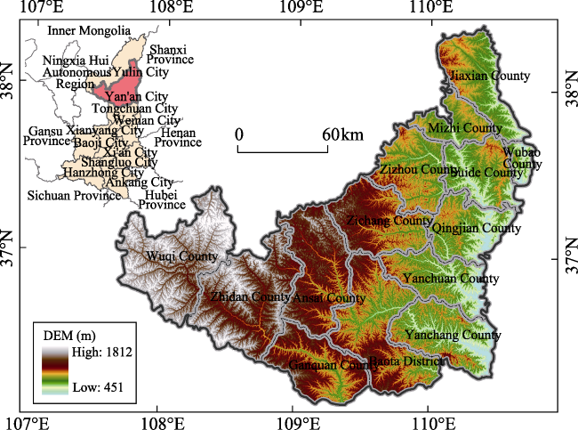
Figure 1 Location and elevation of the loess hilly-gully region of northern Shaanxi Province

2.2 Data source and processing

The data in this paper include digital elevation model (DEM) data, soil texture data, soil erosion data and soil-type data for 199, national 1-km grid population data (Fu et al., 2014), national 1-km grid GDP data (Huang et al., 2014) and land-use and coverage data (Liu et al., 2014; Liu et al., 2010) of 1995, 2000, 2005, 2010 and 2015, daily precipitation data from the China Meteorological Assimilation Driving Datasets for the SWAT model (CMADS) (Shi et al., 2011; Meng et al., 2016a, 2017) for 1995, and research zone vector boundary data.
Of these, the soil erosion data, population data, GDP data, land-use and coverage data, soil texture data, soil-type data, and vector boundary data come from the resources and environmental science data center of the Chinese Academy of Sciences (CAS) (http://www.resdc.cn), DEM data come from the geospatial data cloud on the computer network information center of CAS (http://www.gscloud.cn). Advanced Spaceborne Thermal Emission and Reflection Radiometer Global DEM data have a spatial resolution of 30 m. Precipitation data come from the Heihe Plan Data Center and the Cold & Arid Regions Scientific Data Center (http://westdc.westgis.ac.cn).

2.3 Research methods

This study uses spatial analysis, grid interpolation, natural breakpoints, and geodetection. Spatial analysis is used to extract data on soil erosion, land use, population, GDP, and elevation within the research zone. Soil erosion raster data are converted to 1-km grid data to construct a spatial lattice from which spatial values for each factor are extracted using lattice extraction methods. We use ArcGIS9.3 software’s grid interpolation feature to obtain precipitation data by interpolating the maximum daily precipitation recorded at each meteorological station in the study area. We use DEM data to obtain elevation, slope, and aspect data and use natural breaks optimization to reclassify precipitation, soil texture, population, GDP, and slope data to obtain optimal data discretization. Geodetection is used to identify the dominant factors causing soil erosion and quantify their respective effects.
(1) Grid interpolation is a method to estimate continuous data trends from discrete data points using fitting calculations. We tried both the inverse distance weighted interpolation and spline interpolation in ArcGIS9.3 software to interpolate maximum daily precipitation, using data from weather stations in the study area. Inspection of the results indicates that, for our purposes, spline interpolation is superior to inverse distance weighted interpolation. Therefore, we proceeded with the spline interpolation results and discarded the inverse distance weighted interpolation results.
(2) The natural breaks method relies on natural breaks that exist between groups in the data. It uses statistical methods to determine the natural groupings in the data by reducing the average discrete variance within each group and increasing the average discrete variance between groups. It completely relies on the distribution of data. There is no human influence in the process. Natural breaks methods are applied to precipitation, soil type, aspect, GDP, and population data to obtain spatial clustering that meets the requirements for geodetection and discretization of spatial data.
(3) Geodetection is based on the spatial variation in geographic features or phenomena. It uses statistical methods to analyze driving forces. In principle, if some independent variable has a significant effect on some dependent variable, then the spatial distribution of the independent and dependent variables should be similar (Wang et al., 2017).
Geodetection was first used in disease risk assessment (Wang et al., 2010). Geodetectors can detect spatial patterns and mechanisms of causal elements. It is a powerful tool for spatial differentiation analysis (Wang et al., 2016). It has two main advantages over other spatial analysis methods. First, it can deal with both quantitative and qualitative data. Second, it can detect the influence of two interacting independent variables on a certain dependent variable.
Its output includes factor detection, interactive detection, risk detection, and ecological detection. Among these, factor detection is used to determine whether a certain factor is related to the spatial distribution of a certain phenomenon. Interactive detection is used to describe the influence (strengthening or weakening) of interacting factors on the spatial distribution of a certain index. Ecological detection is used to determine whether the effect of interacting factors on the spatial distribution of a certain index is significant. It is generally expressed in statistical terms as the value of F. Risk detection is used to quantify risks associated with specific factors. It is generally expressed in statistical terms as the value of T (Zhu et al., 2015; Cao et al., 2013). Essentially, this method compares the total variance of an index in different types of areas with its total variance over the entire research zone. It is calculated as follows (Wang and Xu, 2017):
${{q}_{x,y}}=1-\frac{1}{n\sigma _{y}^{2}}\underset{i=1}{\overset{m}{\mathop \sum }}\,{{n}_{x,i}}\sigma _{{{y}_{x,i}}}^{2}$ (1)
where y is a dependent variable, x is an independent variable, qx,y is the degree to which x explains y, n and σ2 are the number of samples and the variance, respectively, m is the number of types of a certain factor, and n x,I is the number of samples of index x that are of type i. The range of qx,y values is [0, 1]. When qx,y = 0, the spatial distribution of y is not affected by x. The larger the value of qx,y, the greater the influence of x on y.
This paper uses geodetection for detecting the factors that influence soil erosion in the loess hilly-gully region of northern Shaanxi Province, quantitatively analyzing the influence each factor has on soil erosion, and determining whether combinations of factors promote soil erosion. To characterize the influence of the various factors affecting soil erosion and determine the main factors that drive soil erosion and the mechanisms of interacting factors, we analyzed land coverage, population, and GDP data from different years with constant soil erosion conditions.

3 Results and analysis

3.1 Analysis of the spatial variation in soil erosion

Soil erosion is the result of interactions among several geographic elements that may promote or inhibit soil erosion. The strength of soil erosion is defined by the quantity of earth’s crust per unit area, per unit time, that is eroded and transported away by natural (hydraulic, wind, gravity, freezing and thawing, etc.) and human activities. It is measured in tons per square kilometer per annum [t/(km2·a)]. Another way to measure soil erosion is simply to use the change in the elevation at a given point in millimeters per year (mm/a). To classify the strength of soil erosion, we use allowable erosion and national maximum erosion as the two extreme values. Between these two extremes, there are six nationally standardized levels of erosion: slight, minor, moderate, intense, very intense, and extreme.
China is a large country with complex natural conditions. Each region has its own major causes of erosion. The nature of erosion varies significantly from place to place. That is to say, we can categorize soil erosion into three major types: hydraulic erosion, wind erosion, and freeze/thaw erosion. In the loess hilly-gully region of northern Shaanxi Province, erosion is mainly caused by flowing water and precipitation, so it can be classified as hydraulic erosion.
The soil erosion data used in this paper come from the resources and environmental science data center of the Chinese Academy of Sciences. The spatial distribution data for soil erosion is formatted according to the Soil Erosion Classification and Grading Standards (MWRPRC, 1997). By extraction and classification of the soil erosion spatial distribution data from the study area, we obtain the following soil erosion spatial distribution data for the loess hilly-gully region of northern Shaanxi Province.
Soil erosion in the research zone is divided into six grades. Figure 2 shows clear spatial variation. Areas with relatively minor erosion are Ganquan County, southern Baota District, and southern Zhidan County. Areas with extreme soil erosion are mainly in the north and east, including Jiaxian County, Suide County, Mizhi County, Zizhou County, Wubao County, and Zichang County. We see sporadically distributed minor-to-extreme soil erosion in Zhidan County, Wuqi County, Ansai County, and northern Baota District in the western part of the study area.
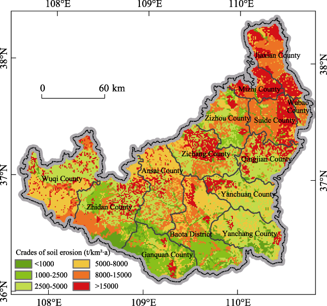
Figure 2 Spatial distribution and grades of soil erosion in the loess hilly-gully region of northern Shaanxi Province in 1995
Quantitative analysis of the erosion level in the study area reveals that grade 3 “moderate” erosion accounts for the largest area of being 26.69% (Table 1). Next are grade 5 “very intense” areas with 19.52% and grade 4 “intense” areas with 18.74%. The area of grade 6 “extreme” erosion is 17.22%. Grade 2 “minor” and grade 1 “slight” areas account for relatively little of the area in the research zone, with a sum of 17.81%. The above analysis shows that erosion in the research zone is quite severe. Areas with grades 4 through 6 make up much more than half of the study area. Soil and water conservation work in the research zone is very challenging.
Table 1 Quantitative analysis of various soil erosion grades in the loess hilly-gully region of northern Shaanxi Province
Grade number Erosion level Average erosion modulus (t/km2×a) Area (km2) Proportion (%)
1 Slight <1000 2618 8.07
2 Minor 1000-2500 3160 9.74
3 Moderate 2500-5000 8659 26.69
4 Intense 5000-8000 6080 18.74
5 Very intense 8000-15000 6333 19.52
6 Extreme >15000 5587 17.22

3.2 Analysis of the primary causes of soil erosion

Based on geodetection, we analyzed the major causes of spatial variation in soil erosion in the loess hilly-gully region of northern Shaanxi Province. The results (Table 2) show that the major factors, in order of importance, are: population > precipitation > land-use type > elevation > soil type > soil sand content > soil silt content > soil clay content > GDP > slope > aspect.
Table 2 Determinants of soil erosion in the loess hilly-gully region of northern Shaanxi Province
Influencing factor Population Precipitation Land-use type Elevation Soil type Sand content
q value 0.127102 0.102612 0.066366 0.027132 0.018847 0.015876
Influencing factor Silt content Clay content GDP Slope Aspect
q value 0.009635 0.004776 0.003131 0.001543 0.000789
The analysis above indicates that the main factors influencing soil erosion in the loess hilly-gully region of northern Shaanxi Province are human population, precipitation, and land-use type. This is consistent with the results of Wang et al. (1998, 2000, 2008). However, slope and aspect had little effect on soil erosion in our study. This contrasts with the results of Li et al. (2000) and Wang et al. (1998). Observations of small watersheds and simulation results indicate that topographical characteristics like slope and aspect are important factors affecting soil erosion. Also, Wang et al. (1998) and Li et al. (2000) placed slope at the top of the list of factors influencing soil erosion in the loess hilly-gully region of northern Shaanxi Province, followed by precipitation and land use. Many later simulations and studies related to soil erosion in the region have based their analyses and evaluations on the assumption that slope, precipitation, and land use are the main factors influencing soil erosion.
Our analysis discovered that the effects of slope and aspect are unclear. This is related to the limitations of geodetection. Geodetection relies on clear spatial differences in geographical phenomena and interactions between influencing factors. Also, independent variables must be type variables. The topography of the land in the study area is fractured with hills and gullies. Tian et al. (2013) found that the gully density in the Loess Plateau of northern Shaanxi is generally greater than 7 km/km2, and, in some places, it is greater than 10 km/km2. The unusually fractured topographic characteristics make it difficult to extract clear spatial variations and an agglomeration of slope and aspect based on DEM data. Therefore, geodetection methods cannot easily analyze the effects of slope and aspect on soil erosion.
The interaction survey (Table 3) in geodetection is used to identify the mechanisms by which risk factors interact. It analyzes the effect of combining risk factors on their ability to explain dependent variables and thereby judges the mechanisms by which pairs of risk factors affect dependent variables. Interaction survey results show that, compared with their individual effects, combinations of precipitation, population, land-use type, and elevation are much more potent. This shows that soil erosion prevention and control efforts must not simply address the major risk factors but approach the problem from a holistic, regional perspective.
Table 3 Factor interaction survey results matrix in the loess hilly-gully region of northern Shaanxi Province
Precipitation Land-use type Population Soil type Elevation
Precipitation 0.1026 - - - -
Land-use type 0.1534 0.0664 - - -
Population 0.2062 0.1805 0.1271 - -
Soil type 0.1207 0.0895 0.1441 0.0188 -
Elevation 0.1318 0.0940 0.1882 0.0538 0.0271

Note: Due to space limitations, the table only displays a portion of the interaction results.

3.3 Time dependency of the effects of driving factors on soil erosion

Using data series from 1995, 2000, 2005, 2010, and 2015, we discovered that, by using soil erosion data as the dependent variable and land coverage data as the independent variable in the geodetection force of determination analysis, soil erosion was progressively less dependent on the effects of land coverage (q value). The statistical information about the area of each type of land use in the study area (Table 4) indicates that as the blend of land-use types changes, the magnitude of the effect of land use on soil erosion is also changing. Referring to related data, we can see that there are significant differences in the resistance to soil erosion in the Loess Plateau region based on different land-use types. In order of decreasing resistance to erosion, the land-use types are: forest > grassland > wetland > urban infrastructure > unused land > cultivated land.
Table 4 The effect of land coverage changes on the q value in the loess hilly-gully region of northern Shaanxi Province
Year q value Cultivated land area (km2) Forested area (km2) Grassland area (km2) Wetland area (km2) Urban and industrial infrastructure area (km2) Unused land (km2) Ratio of forest and grassland (%)
1995 0.066 16100 4080 17204 233 124 59 55.22
2000 0.059 16669 4695 16834 202 80 64 55.86
2005 0.049 15790 5638 16754 201 97 64 58.09
2010 0.048 15712 5727 16745 198 98 64 58.30
2015 0.047 15759 5688 16649 203 135 110 57.95
The land coverage change patterns in the Loess Plateau of northern Shaanxi Province from 1995 to 2015 showed (Table 4) that, the area of cultivated land, grassland, and wetland in the region decreased. Over that 20-year period, the cultivated land area decreased by 341 km2, grassland decreased by 555 km2, and wetland area decreased by 30 km2. Forested area, urban infrastructure area, and unused land area all increased. Over that 20-year period, forested area increased by 1608 km2, urban infrastructure area increased by 11 km2, and unused land area increased by 51 km2. If we look at the ratio of forest and grassland in the study area, we see that it increases from 55.22% in 1995 to 57.95% in 2015.
This means that there is a negative correlation between the area of forest and grassland and severe soil erosion. That is, increasing the proportion of forest and grassland in the study area helps increase the region’s resistance to soil erosion. Therefore, by converting fields to forests and grasslands, the severity of soil erosion in the loess hilly-gully region of northern Shaanxi Province can be effectively mitigated. Converting fields to forests and grasslands helps protect the region’s ecosystems and provides a path toward sustainable development.
When we analyze the population and GDP data from 1995, 2000, 2005, and 2015 in the same way, we discover that, as population and GDP increase, the q value corresponding to population and GDP also decreases. Referring to related data, we discover that, as urbanization in China continues, the population is becoming more concentrated in urban areas. Combined with rapid economic development, this means that urban GDP is also on the rise. In the loess hilly-gully region of northern Shaanxi Province, urban areas are mainly distributed in flat, open areas. Also, urban planners are becoming more concerned about environmental protection. Therefore, although population and GDP have both increased, their combined effects have contributed to decreasing soil erosion. This means that, as the degree of urbanization continues to rise, the human population continues to become more concentrated in urban areas. Economic production thus becomes more efficient, which is beneficial to the region’s ecological conservation.

4 Discussion

Most current research on soil erosion in the loess hilly-gully region is based on data from point observations, models of sediment production from slopes, and watershed-scale modeling. There is relatively little research on the dominant factors influencing soil erosion on a regional scale. This paper carried out geodetection analysis using soil erosion datasets from 1995 through 2015. With soil erosion as the dependent variable, and human population, land-use type, multi-year precipitation, topography, soil data, etc. from the same year as independent variables, we studied the driving factors of soil erosion on a regional scale. We revealed the individual and pairs of driving factors that most influenced soil erosion to enrich the body of research on soil erosion in the region.
However, there is room for further study to make our results more complete. (1) The factor selection and methods did not completely consider the spatial scale and special characteristics of the topography in the study area. This caused some of the known driving factors of erosion (slope and aspect) to have no significant effects in our regional-scale geodetection analysis. This result contradicts the results of other studies. This is a problem of spatial scale that needs to be addressed in future studies of soil erosion in the loess hilly-gully region of northern Shaanxi Province. (2) The interaction analysis based on geodetection can only evaluate the interaction of pairs of risk factors. The simultaneous interactions of more than two factors cannot be effectively analyzed. Therefore, future researchers may choose to use different methods and models to analyze the driving factors and mechanisms of soil erosion. Also, the interaction mechanisms revealed in this paper are for regional-scale interactions. Their connections with driving factor mechanisms at the watershed scale need to be analyzed in more depth.

5 Conclusions

This paper studied the major factors driving soil erosion in the loess hilly-gully region of China’s northern Shaanxi Province. We analyzed these factors and their interactions using geodetection and spatial variation. We confirmed the statistically significant driving forces behind soil erosion and looked at the relative influence of population, land-use type, GDP, etc. at different period of time. We explored the changes in the ways that the driving factors affect soil erosion over time. Our study shows:
(1) Soil erosion in the loess hilly-gully region of northern Shaanxi is mainly hydraulic erosion. It is divided into six levels of severity: slight, minor, moderate, intense, very intense, and extreme. Among them, the extreme, intense and very intense eroded areas are 18,000 km2, accounting for 55.48% of the total land area, and the slight and minor eroded areas are 5778 km2, accounting for 17.81%. There is significant spatial variation in the severity of soil erosion. It is relatively less severe in the south and more extreme in the north. The center and west are intermediately eroded.
(2) Using geodetection survey analysis, we determined that the main driving factors behind soil erosion in the loess hilly-gully region of northern Shaanxi have both natural and artificial elements. They are: human population, precipitation, land-use type, soil type, elevation, sand content of the soil, etc. The spatial distribution of the human population had the greatest effect. The q value was 0.127. Next was precipitation with a q value of 0.103. Factor interaction analysis revealed that pairs of factors, such as the spatial distribution of the human population, precipitation, land-use type, slope, etc. had synergistic mechanisms. That is, the soil erosion effects of certain combinations were more severe than the sum of their individual effects. For example, the q value of single factor of precipitation is 0.1026, however, when precipitation factor works with land-use type, population, soil type and elevation factors the q values are 0.1534, 0.2062, 0.1206, and 0.1318, which are higher than the former.
(3) The impact of land cover change on soil erosion has been reduced from 0.066 to 0.047 between 1995 and 2015. Changes in the proportions of land-use types over time have led to decreasing soil erosion. Analysis showed that this is related to an increase in the proportion of vegetation coverage in the study area over time with positive ecological effects. Further analysis showed that, while the human population and GDP have continued to increase in the region, urbanization has led to a more spatially concentrated human population and GDP production, with clear benefits to both ecological preservation and sustainable development.
(4) Ecological protection measures such as returning farmland to forests and grasses can effectively reduce the degree of soil erosion in the loess hilly-gully region of northern Shaanxi. According to the land cover change data of the study area (Table 4), the areas of cultivated land, grassland, and wetland in the region decreased during 1995-2015, and forested area, urban infrastructure area, and unused land area were all increased. The forest land increased by 1608 km2 in the 20 years. The proportion of forest and grassland area in the study area increased from 55.22% in 1995 to 57.95% in 2015. These changes indicate that the proportion of ecological land area such as forest and grassland is negatively correlated with the severity of soil erosion. According to the existing research results, the anti-erosion ability of forest land in the Loess Plateau is the strongest. Therefore, the policies of returning farmland to forest and grassland plays an important role in improving soil anti-erosion capability and in preventing soil loss.

The authors have declared that no competing interests exist.

[1]
Cao F, Ge Y, Wang J F, 2013. Optimal discretization for geographical detectors-based risk assessment.GIS Science & Remote Sensing, 50(1): 78-92.

[2]
Cao Z, Li Y R, Liu Y Set al., 2017. When and where did the Loess Plateau turn “green”? Analysis of the tendency and breakpoints of normalized difference vegetation index.Land Degradation and Development, 1-14.Abstract The Loess Plateau experiences the most serious soil erosion problems in China and possibly even globally. Many measures have been taken to increase the vegetation cover and to control soil erosion. Of these measures, the Grain for Green Project, launched in 1999, has been the most effective, changing the ecological and socio-economic situation of the Plateau significantly. Using time series normalized difference vegetation index (NDVI) data from 1981 to 2013, this study analysed spatial patterns of changes in vegetation cover, detected spatial patterns of the abrupt-change time of NDVI trends, and investigated factors that may contribute to these changes. The results showed that (a) vegetation restoration was obvious over the last decades, especially in the 2000s, and the increase in NDVI during 2000–2013 was more than 3-times that during 1990–2000. Approximately 54.99% of the Plateau during 2000–2013 had a statistically significant increase, mainly distributing in loess hilly and gully region and loess gully region. (b) Vegetation restoration was comprehensively affected by climate change and human activities (e.g., the Grain for Green Project, urbanization and policies), and the effects of each factor varied for different regions. (c) Vegetation in most of the Plateau began to increase around 2007–2010, and 4 discrete areas with different timings of such break points were detected. The difference in the timing of break points in NDVI may be related with precipitation, reproducing tree species, management measures, and survival rate. These results imply that integrating natural and human factors is important when making effective and suitable measures and policies.

DOI

[3]
Ding W F, Huang C H, 2017. Effects of soil surface roughness on interrill erosion processes and sediment particle size distribution.Geomorphology, 295: 801-810.

DOI

[4]
Dong Y X, Xu Q, Yang Ret al., 2017. Delineation of the northern border of the tropical zone of China’s mainland using Geodetector.Acta Geographica Sinica, 72(1): 135-147. (in Chinese)The northern border of the tropical zone of China has been the focus of studies on comprehensive physical regionalization. Based on different indexes and methods, the border was delineated by different scholars, but their results varied greatly. Based on the Geodetector model and regionalization thought of spatial stratified heterogeneity, the northern border of the tropical zone of China's mainland was investigated. Climatic elements were used as dominant demarcation partitioning indexes, combined with auxiliary indexes such as soil and multiple cropping types. The key results were as follows:(1) Using Geodetector, the northern border of the tropical zone was delineated. From west to east, the border goes through Lincang, Simao,Yuxi and Gejiu in Yunnan, Baise, Mashan, Guigang and Wuzhou in Guangxi, Zhaoqing,Guangzhou, Huizhou, Heyuan and Meizhou in Guangdong, and Zhangzhou, Quanzhou and Putian in Fujian. It generally agrees with the 12℃ isotherm of the coldest monthly mean temperature, soil border between lateritic red soil and red soil, and border of double cropping rice or its continuous thermophile dry framing and single(double) cropping rice or its continuous chimonophilous dry framing.(2) The q average value of all indexes for the border was 0.40. Using this model, regionalization principles—homogeneity of the within-strata value and heterogeneity of the between- strata value—were satisfied. The border meets the requirements of zonal heterogeneity between tropical and subtropical zones. Therefore, it is reasonable to use Geodetector in studies of comprehensive physical regionalization, and it can provide high-precision technical support.

DOI

[5]
Fu J Y, Jiang D, Huang Y H, 2014. 1 km grid population dataset of China (Population Grid_China), Global Change Research Data Publishing & Repository. doi: 10.3974/geodb.2014.01.06.V1. (in Chinese)

[6]
Gao H D, Li Z B, Li Pet al., 2015. The capacity of soil loss control in the Loess Plateau based on soil erosion control degree.Acta Geographica Sinica, 70(9): 1503-1515. (in Chinese)

[7]
Han J C, Liu Y S, Zhang Y G, 2015. Sand stabilization effect of feldspathic sandstone during the fallow period in Mu Us Sandy Land.Journal of Geographical Sciences, 25(4): 428-436.Depended on the analysis of ground snow situation, soil moisture loss speed and soil structure after planting crops of Mu Us Sandy Land remedied with feldspathic sandstone in the fallow period, it is concluded that feldspathic sandstone mixed with sand improved the sand stabilization in the governance of Mu Us Sandy Land in the fallow period. The sandy land remedied with feldspathic sandstone had big snow coverage, 25%–75% higher than normal sand; soil moisture losses slowed down, and moisture content rose by over 3 times; soil structure had been improved, and water stable aggregate content increased by 6.52%–18.04%; survival rate of protection forest increased to 85%; and ground flatness is less than 1%. The above conditions weakened sand rising conditions of Mu Us Sandy Land in the fallow period and formed two protective layers of snow cover and soil frozen layer under cold weather so as to prevent against wind erosion.

DOI

[8]
Hu Y, Wang J F, Li X Het al., 2011. Geographical detector-based risk assessment of the under-five mortality in the 2008 Wenchuan earthquake, China.PloS One, 6(6): e21427.On 12 May, 2008, a devastating earthquake registering 8.0 on the Richter scale occurred in Sichuan Province, China, taking tens of thousands of lives and destroying the homes of millions of people. Many of the deceased were children, particular children less than five years old who were more vulnerable to such a huge disaster than the adult. In order to obtain information specifically relevant to further researches and future preventive measures, potential risk factors associated with earthquake-related child mortality need to be identified. We used four geographical detectors (risk detector, factor detector, ecological detector, and interaction detector) based on spatial variation analysis of some potential factors to assess their effects on the under-five mortality. It was found that three factors are responsible for child mortality: earthquake intensity, collapsed house, and slope. The study, despite some limitations, has important implications for both researchers and policy makers.

DOI PMID

[9]
Huang Y H, Jiang D, Fu J Y, 2014.1 km grid GDP data of China (2005, 2010) (GDPGrid_China), Global Change Research Data Publishing & Repository. doi: 10.3974/geodb.2014.01.07.V1.

[10]
Li X W, Xie Y F, Wang J Fet al., 2013. Influence of planting patterns on fluoroquinolone residues in the soil of an intensive vegetable cultivation area in north China. Science of the Total Environment, 458-460: 63-69.61The vegetable planting model is the major determinant of FQ difference in soil.61Planting age could not result in spatial pollution differences.61Interactions between risk factors should be given more concern.

DOI PMID

[11]
Li Y, Zhang J H, Yang J Cet al., 2000. Spatial patterns of soil erosion on steep cultivated hillslope in Loess Plateau of Northern Shaanxi.Journal of Soil and Water Conservation, 14(4): 17-21. (in Chinese)

[12]
Liang P, Yang X P, 2016. Landscape spatial patterns in the Maowusu (Mu Us) Sandy Land, northern China and their impact factors. Catena, 145: 321-333.61Application of the Geographical detector model over a sandy land in north China61Assessment of the relative importance of driving forces on landscape spatial patterns61Analysis of the causes of landscape distribution on different scales61Discussion about the role of human activities in shaping the Maowusu landscape

DOI

[13]
Liu G B, Wang B, Wei W, 2016. Technique and demonstration of water and soil loss comprehensive harness on the Loess Plateau. Acta Ecologica Sinica, 36(22): 7074-7077. (in Chinese)On the loess plateau of China,soil and water losses are serious and the ecological environment is fragile. This region is also considered as an integral part of the Strategy of Ecological Security of China. To recovery the ecosystem and to develop the industry on the Loess Plateau, researching and integrating technology and establishing experiment and demonstration prototype are urgent affairs in this region. The specific project of "Technology and demonstration of water and soil loss comprehensive harness on the Loess Plateau( 2016YFC0501700) "is a part of the national key research and development plan of "Restoration and Protection of Typical Fragile Ecology". In this project,the main issue is to solve the Scientific and technical problems for the ecology sustained restoration and ecology security,based on the soil and water conservation technology developing and integrating though the six typical regions in the regional scale.

DOI

[14]
Liu J Y, Kuang W H, Zhang Z Xet al., 2014. Spatiotemporal characteristics, patterns and causes of land-use changes in China since the late 1980s.Journal of Geographical Sciences, 24(2): 195-210.

DOI

[15]
Liu J Y, Zhang Z X, Xu X Let al., 2010. Spatial patterns and driving forces of land use change in China during the early 21st century,Journal of Geographical Sciences, 20(4): 483-494.Land use and land cover change as the core of coupled human-environment systems has become a potential field of land change science (LCS) in the study of global environmental change. Based on remotely sensed data of land use change with a spatial resolution of 1 km * 1 km on national scale among every 5 years, this paper designed a new dynamic regionalization according to the comprehensive characteristics of land use change including regional differentiation, physical, economic, and macro-policy factors as well. Spatial pattern of land use change and its driving forces were investigated in China in the early 21st century. To sum up, land use change pattern of this period was characterized by rapid changes in the whole country. Over the agricultural zones, e.g., Huang-Huai-Hai Plain, the southeast coastal areas and Sichuan Basin, a great proportion of fine arable land were engrossed owing to considerable expansion of the built-up and residential areas, resulting in decrease of paddy land area in southern China. The development of oasis agriculture in Northwest China and the reclamation in Northeast China led to a slight increase in arable land area in northern China. Due to the "Grain for Green" policy, forest area was significantly increased in the middle and western developing regions, where the vegetation coverage was substantially enlarged, likewise. This paper argued the main driving forces as the implementation of the strategy on land use and regional development, such as policies of "Western Development", "Revitalization of Northeast", coupled with rapidly economic development during this period.

DOI

[16]
Liu Y S, 2018. Introduction to land use and rural sustainability in China.Land Use Policy, 74(5):1-4.Urban-rural transformation and rural development are issues at the forefront of research on the topic of the urban-rural relationship in the field of geography, as well as important practical problems facing China’s new urbanization and overall planning of urban and rural development. The Center for Regional Agricultural and Rural Development, part of the Institute of Geographic Sciences and... [Show full abstract]

DOI

[17]
Liu Y S, Fang F, Li Y H, 2014. Key issues of land use in China and implications for policy making.Land Use Policy, 40(4): 6-12.The paper aims to comprehensively analyze key issues of current land use in China. It identifies the major land-use problems when China is undergoing rapid urbanization. Then, the paper interprets and assesses the related land-use policies: requisition-compensation balance of arable land, increasing vs. decreasing balance of urban-rural built land, reserved land system within land requisition, rural land consolidation and economical and intensive land use. The paper finds that current policies are targeting specific problems while being implemented in parallel. There is lacking a framework that incorporates all the policies. The paper finally indicates the current land-use challenges and proposes strategic land-use policy system to guide sustainable land use in the future.

DOI

[18]
Liu Y S, Li J T, 2017. Geographic detection and optimizing decision of the differentiation mechanism of rural poverty in China.Acta Geographica Sinica, 72(1): 161-173. (in Chinese)Rural poverty has long aroused attention from countries around the world, and eliminating poverty and achieving realize common prosperity is an important mission to build the well- off society in an all- round way. Scientifically revealing the regional differentiation mechanism of rural poverty has become an important issue of implementation of national poverty alleviation strategy. This paper, taking Fuping County of Hebei Province as a typical case, diagnoses the dominant factors of differentiation of rural poverty and reveals the dynamic mechanism of rural poverty differentiation by using the Geodetector model and multiple linear regressions, and puts forward the poverty alleviation policies and models for different poverty regions. The result shows that the dominant factors affecting rural poverty differentiation include slope, elevation, per capita arable land resources, distance to the main roads and distance to the center of county, and their power determinant value to poverty incidence differentiation are 0.14, 0.15, 0.15, and 0.17. These factors affect the occurrence of poverty from different aspects and their dynamic mechanism is also different. Among various factors, the slope and per capita arable land resources affect the structure and mode of agricultural production, while distance to the main roads and distance to the center of county have influence on the relationship between the interior and exterior of the region. There are significant differences in the four types identified of regional rural poverty, namely,environment constrained region mainly affected by slope(seven towns), resource oriented region mainly affected by per capita arable land(seven towns), area dominated by traffic location affected by distance to the main roads(three towns), and economic development leading area mainly affected by distance to the center of county(four towns). Then, Fuping County is divided into single core, dual core and multi- core area according to the number of core elements of the township. The county has shown a multi differentiation of rural poverty with a horizontal center of dual core area, and both sides have a single core and multi- core,which are affected by different dominant factors. Finally, this paper suggests that policy of targeted poverty alleviation should take science and technology as the foundation and form innovation of targeted poverty alleviation according to the core dominant factors of the differentiation mechanism of rural poverty. The county's poverty alleviation and development under different driving mechanisms need orderly promotion of poverty alleviation and integration of urban and rural development strategy with adjusting measures to local conditions, respecting for science, and stressing practical results.

DOI

[19]
Liu Y S, Li Y H, 2017. Revitalize the world’s countryside.Nature, 548(7667): 275-277.

DOI

[20]
Liu Y S, Yang R, 2012. The spatial characteristics and formation mechanism of the county urbanization in China.Acta Geographica Sinica, 67(8): 1011-1020. (in Chinese)

[21]
Liu Z J, Liu Y S, Li Y R, 2018a. Anthropogenic contributions dominate trends of vegetation cover change over the farming-pastoral ecotone of northern China.Ecological Indicators, 95(1): 370-378.

DOI

[22]
Liu Z J, Liu Y S, Li Y R, 2018b. Extended warm temperate zone and opportunities for cropping system change in the Loess Plateau of China. International Journal of Climatology, 38(11): 1-12.

DOI

[23]
Liu Z J, Liu Y S, Wang S Set al., 2018c. Evaluation of spatial and temporal performances of ERA-interim precipitation and temperature in mainland of China.Journal of Climate, 31(11): 4347-4365.

DOI

[24]
Luo W, Jasiewicz J, Stepinski Tet al., 2016. Spatial association between dissection density and environmental factors over the entire conterminous United States.Geophysical Research Letters, 43(2): 692-700.Previous studies of land dissection density (D) often find contradictory results regarding factors controlling its spatial variation. We hypothesize that the dominant controlling factors (and the interactions between them) vary from region to region due to differences in each region's local characteristics and geologic history. We test this hypothesis by applying a geographical detector method to eight physiographic divisions of the conterminous United States and identify the dominant factor(s) in each. The geographical detector method computes the power of determinant (q) that quantitatively measures the affinity between the factor considered and D. Results show that the factor (or factor combination) with the largest q value is different for physiographic regions with different characteristics and geologic histories. For example, lithology dominates in mountainous regions, curvature dominates in plains, and glaciation dominates in previously glaciated areas. The geographical detector method offers an objective framework for revealing factors controlling Earth surface processes.

DOI

[25]
Meng Q X, Liu G B, Yang Q K, 2008. Soil erosion change on the Loess Plateau.Research of Soil and Water Conservation, 15(3): 20-22. (in Chinese)Using GIS and relation data,soil erosion change on the Loess Plateau was analyzed in 1986,2000 and 2002.Erosion area rate is 66.13% in 1986,and it raise to 67.14% in 2000,but reduce to 64.88% in 2002.Thereinto,water erosion area exhibited wide trend,wind erosion is reducing,freeze-thaw erosion increased and then decreased from 1986 to 2002.On the Loess Plateau,soil erosion area rate in Inner Mongolia,north of Shaanxi province,Gansu province and Ningxia Hui Aotonomous Region is higher,and is smaller in Qinghai province,middle of Shaanxi province,Hetao plain,Ningxia plain and some areas of Shanxi province.The erosion area rate is 60%~70% from 1986 to 2002,therefore the soil and water erosion is severe as a whole,it is a long way to finish the aim of Green mountain and Clear river.

DOI

[26]
Meng X Y, Shi C X, Liu S Y, 2016a. CMADS datasets and its application in watershed hydrological simulation: A case study of the Heihe River Basin.Pearl River, 37(7): 1-19. (in Chinese)

[27]
Meng X Y, Wang H, Cai S et al., 2016b. The China Meteorological Assimilation Driving Datasets for the SWAT Model (CMADS) Application in China: A case study in Heihe River Basin. Preprints, 2016: 120091. doi: 10.20944/preprints201612.0091.v2.

[28]
Meng X Y, Wang H, Lei X Het al., 2017. Hydrological Modeling in the Manas River Basin using soil and water assessment tool driven by CMADS.Tehnicki Vjesnik - Technical Gazette, 24(2): 525-534. doi: 10.17559/TV-20170108133334.

[29]
Ministry of Water Resources of the People’s Republic of China (MWRPRC), 1997. Standards for Classification and Gradation of Soil Erosion, SL190-96. (in Chinese)

[30]
Shi C X, Xie Z H, Qian Het al., 2011. China land soil moisture EnKF data assimilation based on satellite remote sensing data.Science China Earth Sciences. doi: 10.1007/s11430-010-4160-3.Soil moisture plays an important role in land-atmosphere interactions. It is an important geophysical parameter in research on climate, hydrology, agriculture, and forestry. Soil moisture has important climatic effects by influencing ground evapotranspi ration, runoff, surface reflectivity, surface emissivity, surface sensible heat and latent heat flux. At the global scale, the extent of its influence on the atmosphere is second only to that of sea surface temperature. At the terrestrial scale, its influence is even greater than that of sea surface temperatures. This paper presents a China Land Soil Moisture Data Assimilation System (CLSMDAS) based on EnKF and land process models, and results of the application of this system in the China Land Soil Moisture Data Assimilation tests. CLSMDAS is comprised of the following components: 1) A land process mo del ommunity Land Model Version 3.0 (CLM3.0) eveloped by the US National Center for Atmospheric Research (NCAR); 2) Precipitation of atmospheric forcing data and surface-incident solar radiation data come from hourly outputs of the FY2 geostationary meteorological satellite; 3) EnKF (Ensemble Kalman Filter) land data assimilation method; and 4) Observa tion data including satellite-inverted soil moisture outputs of the AMSR-E satellite and soil moisture observation data. Results of soil moisture assimilation tests from June to September 2006 were analyzed with CLSMDAS. Both simulation and assimila tion results of the land model reflected reasonably the temporal-spatial distribution of soil moisture. The assimilated soil mois ture distribution matches very well with severe summer droughts in Chongqing and Sichuan Province in August 2006, the worst since the foundation of the People Republic of China in 1949. It also matches drought regions that occurred in eastern Hubei and southern Guangxi in September.

DOI

[31]
Tang K L, 2004. China Soil and Water Conservation. Beijing: Science Press. (in Chinese)

[32]
Tian J, Tang G A, Zhou Yet al., 2013. Spatial variation of gully density in the Loess Plateau.Scientia Geographica Sinica, 33(5): 622-628. (in Chinese)Gully density is used to describe the intensity of regional soil erosion and landform development,which is significant to understand the spatial pattern and formation mechanism of loess landforms by analyzing the spatial distribution.According to the principal of quadrat analysis,this article represent a series of maps revealing the spatial distribution of gully density in the Loess Plateau through digital terrain analysis method and Kriging interpolation model,as well as 5 m 5 m DEM data sets.The spatial variation characteristics of gully in the Loess Plateau were investigated.Moreover,some controlling factors on gully development were explored,and relationship between gully density and soil erosion was revealed.Results showed that the spatial variation feature of gully density was obvious,and gully density reached the peak in region of Suide-Mizhi in northern Shaanxi,then,it decreased from north to south in the Loess Plateau.On the macroscopic,the distribution trend of gully was controlled by geological structure so that it was classified into three parts.To the west of the Liupan Mountains as the first part,its value was low with smooth changes.The second part located in the middle and southern parts of the Loess Plateau to the east of the Liupan Mountains,the west of the Luliang Mountains,and its value decreased in gradient from north to south.To the east of the Luliang Mountains as the third part,its value ranged from 1.7 to 6.4 km/km2with fluctuant change.Rainfall intensity was rather significant for spatial variability of gully erosion,which was coupled with the diversification of gully density in space.In addition,vegetation condition and composition of ground material in the Loess Plateau varied from northwest to southeast,which influenced gully development.Gully density was positively and strongly correlated with the sediment transport modulus in the soil erosion in spatial,especially for regions of the middle Loess Plateau,indicating it is an important factor reflecting the capacity of gully erosion.In conclusion,gully density was significantly indicative on understanding the spatial pattern of loess landform.

[33]
Wang J F, Li X H, Christakos Get al., 2010. Geographical detectors-based health risk assessment and its application in the neural tube defects study of the Heshun region, China.International Journal of Geographical Information Science, 24(1): 107-127.

DOI

[34]
Wang J F, Xu C D, 2017. Geodetector: Principle and prospective.Acta Geographica Sinica, 72(1): 116-134. (in Chinese)Spatial stratified heterogeneity is the spatial expression of natural and socioeconomic process, which is an important approach for human to recognize nature since Aristotle. Geodetector is a new statistical method to detect spatial stratified heterogeneity and reveal the driving factors behind it. This method with no linear hypothesis has elegant form and definite physical meaning. Here is the basic idea behind Geodetector: assuming that the study area is divided into several subareas. The study area is characterized by spatial stratified heterogeneity if the sum of the variance of subareas is less than the regional total variance; and if the spatial distribution of the two variables tends to be consistent, there is statistical correlation between them. Q-statistic in Geodetector has already been applied in many fields of natural and social sciences which can be used to measure spatial stratified heterogeneity, detect explanatory factors and analyze the interactive relationship between variables. In this paper, the authors will illustrate the principle of Geodetector and summarize the characteristics and applications in order to facilitate the using of Geodetector and help readers to recognize, mine and utilize spatial stratified heterogeneity.

DOI

[35]
Wang J F, Zhang T L, Fu B J, 2016. A measure of spatial stratified heterogeneity.Ecological Indicators, 67: 250-256.Spatial stratified heterogeneity, referring to the within-strata variance less than the between strata-variance, is ubiquitous in ecological phenomena, such as ecological zones and many ecological variables. Spatial stratified heterogeneity reflects the essence of nature, implies potential distinct mechanisms by strata, suggests possible determinants of the observed process, allows the representativeness of observations of the earth, and enforces the applicability of statistical inferences. In this paper, we propose aq-statistic method to measure the degree of spatial stratified heterogeneity and to test its significance. Theqvalue is within [0,1] (0 if a spatial stratification of heterogeneity is not significant, and 1 if there is a perfect spatial stratification of heterogeneity). The exact probability density function is derived. Theq-statistic is illustrated by two examples, wherein we assess the spatial stratified heterogeneities of a hand map and the distribution of the annual NDVI in China.

DOI

[36]
Wang W J, 2016. Assessment of sensitivity of water and soil loss on the Loess Plateau in North Shaanxi Province [D]. Xi’an: Northwest University. (in Chinese)

[37]
Wang Z L, 2000. Analyses of affecting factors of soil erosion and its harms in China.Transactions of the Chinese Society of Agricultural Engineering, 16(4): 32-36. (in Chinese)The factors such as rainfall, landform, vegetation, soil and human activities, etc., which affect soil erosion in China were systemically analyzed. The severe harms such as destroying of land resources,reduction of food supplies, happening of disasters, loss of soil fertilities, pollution of water environment, depositing of lakes and threatening of city safety, etc., which are caused by soil erosion here, were further studied in order for related departments to utilize in making decisions on soil and water conservation and environmental cure in this paper.

[38]
Wang Z L, Jin X Y, Ma C Yet al., 2008. Research on processes and responses of rainfall-runoff-sediment yield on loess hillslope.Journal of Soil and Water Conservation, 22(2): 24-28. (in Chinese)Rainfall and runoff are the main dynamic factors which cause soil erosion on the Loess Plateau.Research on processes of rainfall,runoff and sediment yield can serve as development of process-based mode of soil erosion,soil and water conservation,and ecology construction on loess region.Based on analyzing the data of natural unsteady rainfall,runoff and sediment yield processes observed in Zizhou field experimental station,and applying non-linear modelling technology,the dynamic variational processes and responded relationship of rainfall-runoff-sediment yield on loess hillslope are studied.The research results show that the variation processes of accumulated rainfall amount with rainfall time,the variation processes of accumulated runoff depth with runoff time,the variation processes of accumulated erosion modulus with sediment yield time,the responses of variation processes of accumulated runoff depth to variation processes of accumulated rainfall amount,the responses of variation processes of accumulated erosion modulus to variation processes of accumulated runoff depth are all displayed with non-linear relationships.All of them can be divided into two types and can be described with extanded S curve model and extanded power function model respectively.

DOI

[39]
Wang Z L, Shao M A, 1998. Soil erosion characters of slope land in the 2nd sub-region of Loess Plateau.Research of Soil and Water Conservation, 5(4): 11-21, 97. (in Chinese)On the basis of collected information about erosion in the 2nd Sub-region of LoessPlateau,the research results was revealed: (1 ) the main factors affecting soil erosion in slopeland were precipitation, topography and land use, (2) the main erosion. types were splasherosion, sheet erosion. rill erosion and shallow gully erosion, (3 ) the annunal average erosionmodule was 8 373t/km2, annunal erosion module with 25 slope land and 1O % coverdegree was 1 8OOt/ktn2 , annunal erosion module with 15 ~ 25 slope land and grass-forest landwith 10 %~ 30% cover degree were 1 5OOt/km2 and 1 2OOt/km2 respectively.

[40]
Wang Z L, Shao M A, Chang Q R, 1998. Effects of rainfall factors on soil erosion in Loess Plateau.Journal of Northwest A & F University (Natural Science Edition), 26(4): 106-110. (in Chinese)Based on field investigation and analyses on the data obtained from simulated rainfall experiments,soil erosion is heavily affected by rainfall and are mainly caused by a few of heavy rain in Loess Plateau.There is no surface runoff in most cases when rained.The standard of soil erosion rainstorm was drew up preliminarily.Discussion is made on spatial distribution of various rainfall features.

[41]
Wu R N, Zhang J Q, Bao Y Het al., 2016. Geographical detector model for influencing factors of industrial sector carbon dioxide emissions in Inner Mongolia, China.Sustainability, 8(2): 149.

DOI

[42]
Yang R, Liu Y S, Long H Let al., 2016. Spatial distribution characteristics and optimized reconstructing analysis of rural settlement in China.Scientia Geographica Sinica, 36(2): 170-179. (in Chinese)This study focuses on the distribution characteristics, effect factors and optimized reconstructing analysis of rural settlement in China. Based on electronic map data in 2012 and socioeconomic data of counties in China, the spatial distribution pattern of rural settlement and effect factors have been examined using model of the average nearest neighbor distance and geographical detector method, while the background and mode for rural space optimization reconstruction were analyzed. Main results for this study are as follows: 1) the rural settlement spatial distribution mode consists of cluster, random and uniform discrete distributions in China,while the regional differences were significant. The density of rural settlements is greater in the southeastern region than in the northwest region with Hu Huanyong's population distribution line for the boundary in China.There were a variety of characteristics for the rural settlement distribution in different type of regions. The spatial distribution of rural settlement was intensive, and those spatial distribution modes were mainly random and disperse with a short average nearest neighbor distance in plain areas. On the other side, the density of rural settlement was low, and those spatial distribution modes were mainly cluster relatively with a long average nearest neighbor distance in highland and cold areas and fringes of the desert. In addition, the density of rural settlement was high, and those spatial distribution modes were mainly random in the intersected transition zone between hill and mountain. 2) The dual factors affect the rural settlement distribution from traditional and economy. Although the traditional factors still play a significance role, the influence of the economic developed more and more obviously. There were a large amount of factors attributing to impacting rural settlement distribution, the spatial form of production and life space, including natural topography and water resources natural conditions, etc. That also included traffic condition, industry, economic development level and agricultural modernization. 3) With factors of production non-agriculture in rural region, the rural space need be a reconstructing optimization. The priority selection is to rebuild village-town system for optimizing rural physical space. Theoretically, village-town system is a sort of hierarchical structure, consisting of central regional town,general agricultural town, central village and basic village. 4) The multiple modes will been made use of restructuring rural space in different geographical areas, including balance forms of radiation, radiation disequilibrium forms, multicore equilibrium forms and corridor layout pattern or mixed modes. From the system and the hierarchical logic level to deconstruct the rural space theory for optimization, a reasonable village-town system is rebuilt orderly, which will provide a scientific basis for urban and rural urbanization.

[43]
Zheng F L, Tang K L, Zhang K Let al., 1995. Relationship of eco-environment change and natural erosion and man-made accelerated erosion.Acta Ecologica Sinica, 15(3): 251-259. (in Chinese)he natural landscape of loess plateau have been changed by severe soil erosion. The Zi-wuling forest region provides a good study area for tracing back eco-environmental change and natural erosion and man-made accelerated erosion. Using the methods of typical region investigation, experimental study in site,and chemical analysis of samples,impact of forest vegetation destruction and restoration on soil erosion change,characteristics of natural ero-sion under the condition of natural ecological balance,man-made accelerated erosion caused by forest vegetation destruction,and the processes of man-made accelerated erosion and soil degradation have been analysed and discussed

[44]
Zhong L N, Wang J, Zhao W W, 2017. Comparative analysis of the effect of rainfall pattern and land use pattern on soil erosion in different-scale watersheds: A case study in hilly and gully area of the Loess Plateau.Acta Geographica Sinica, 72(3): 432-443. (in Chinese)Soil erosion has become one of global environmental problems, especially in the Loess Plateau. Controlling soil erosion is of great significance to improve the ecosystem, and protect the ecological security and maintain the harmonious relationship between human beings and nature. We compare the effect of rainfall pattern and land use pattern on soil erosion in different watersheds to improve soil erosion models. Currently, the effect of rainfall and land use on soil erosion is the hot research topics. However, most of the studies are aimed at one single study area, and there is less comparative analysis of rainfall and land use pattern on soil erosion in different-scale watersheds. The neglect of comparative analysis of the effect of rainfall pattern and land use pattern on soil erosion would inevitably influence the further study of the mechanism of soil erosion. And it would affect the simulation accuracy of soil erosion models. The investigation of the effect of land use pattern and rainfall pattern on soil erosion would have great significance to soil erosion research and comprehensive governance of soil erosion problems. With reference to the concept of soil erosion evaluation index, this paper proposed the use of rainfall pattern index and land use pattern index for predicting soil erosion in different watersheds. Otherwise, this paper identified more important factors for soil erosion between rainfall patterns and land use pattern in different-scale watersheds. It has positive significance for carrying out the comprehensive management of soil erosion and land use pattern optimization design. The study areas of this paper are Qingjian River basin, Fenchuan River Basin, Yanhe River Basin and Dali River Basin. The main results are as follows.(1)From 2006 to 2012, the rainfall erosivity factor R in the study area showed an upward trend,while the vegetation cover and management factor C showed a downward trend.(2) When watershed area was small, the effect of rainfall pattern was greater than that of land use pattern on soil erosion. In contrast, when watershed area was large, the effect of land use pattern was greater than that of rainfall pattern on soil erosion. In other words, with the increase of the watershed area, the effect of rainfall pattern on soil erosion was gradually reduced while land use pattern indicated a contrasting effect.(3) With the increase of the watershed area, the proportion of woodland decreased and steep slope vegetation cover types tend to be homogenous, thus increasing the effect of land use pattern on soil erosion in larger-scale watersheds. With the increase of the watershed area, however, loose soil properties and craggy terrain increases the possibility of gravitational erosion, which enhances the effects of soil and topography.

DOI

[45]
Zhu H, Liu J M, Tao H, 2015. Temporal-spatial pattern and contributing factors of urban RBDs in Beijing.Acta Geographica Sinica, 70(8): 1215-1228. (in Chinese)

Outlines

/