Practice of barren hilly land consolidation and its impact: A typical case study from Fuping County, Hebei Province of China

  • WU Yifan , 1 ,
  • FENG Weilun 1 ,
  • ZHOU Yang , 1, 2, 3, *
Expand
  • 1. Faculty of Geographical Science, Beijing Normal University, Beijing 100875, China
  • 2. Institute of Geographic Sciences and Natural Resources Research, CAS, Beijing 100101, China
  • 3. Center for Assessment and Research on Targeted Poverty Alleviation, CAS, Beijing 100101, China
*Corresponding author: Zhou Yang, PhD and Associate Professor, specialized in geography of poverty, rural revitalization and sustainable development. E-mail:

Author: Wu Yifan (1993-), PhD, specialized in land resources and urban-rural development. E-mail:

Received date: 2018-03-18

  Accepted date: 2018-09-20

  Online published: 2019-04-19

Supported by

National Key Research and Development Program of China, No.2017YFC0504701

Key Project of National Social Science Foundation of China, No.15ZDA021

National Natural Science Foundation of China, No.41871183, No.41601172

Copyright

Journal of Geographical Sciences, All Rights Reserved

Abstract

Land is the root of rural revitalization, and its core is to reinvigorate land resources through the building up of land capacity. Since the late 1990s, land consolidation efforts have been widely extended to all parts of China. Land consolidation has served as an essential instrument for reinvigorating stock land, strengthening intensive land use, timely supplementing cultivated land, and promoting agricultural modernization, as well as urban-rural integration. This study uses a typical poor village (Dadao Village) in a state-designated impoverished county (Fuping County, Hebei Province), to analyze the socioeconomic benefits and eco-environmental impacts of land consolidation. With the aid of first-hand data from questionnaire surveys, face-to-face interviews and the visual interpretation of land use and land cover changes (LUCC), we found that: 1) the barren hilly land consolidation (BHLC) helps to promote the transformation of resource-advantages into asset-advantages in poverty-stricken areas. In 2017, 60.16% households in the study area gained the additional transferred-income with an annual average of 2843 yuan, while 19.11% households received the wage-income with an annual average of 9871 yuan. 2) Land consolidation inspires farmers’ enthusiasm to participate in village government and helps alleviate rural poverty. From 2014 to 2017, land consolidation has helped 585 poor in the village out of poverty. Meanwhile, by land consolidation, most farmers’ attitudes towards land consolidation have shifted from “not caring” to “have great concern,” and their identity cognition has gradually changed from being bystanders to becoming decision makers and supervisors. 3) Further analysis demonstrated that land consolidation could not only increase the quantity and quality of arable land, but also have a certain impact on eco-environment. During 2014-2016, the BHLC in the study area transformed 242.12 ha unused barren hilly land and open forest land into well-facilitated arable land, and increased the average arable land by 0.19 ha per capita. Also, the index of land use intensity increased by 27.01% between 2014 and 2016. Farmers’ perceptions of environmental awareness have confirmed that such high-intensity LUCC were significant enough to make two-side impacts on eco-environment. We appeal to establish a combined organization and encouragement mechanism of rural land consolidation, to take the full breadth and depth of farmers’ participation into consideration, and to formulate more scientific and sustainable land consolidation planning. Also, we put forward some suggestions and notes for the implementation and promotion of BHLC model. These findings can provide beneficial references for those involved in policymaking and planning in the areas of land consolidation and poverty alleviation in China, as well as other developing countries around the world.

Cite this article

WU Yifan , FENG Weilun , ZHOU Yang . Practice of barren hilly land consolidation and its impact: A typical case study from Fuping County, Hebei Province of China[J]. Journal of Geographical Sciences, 2019 , 29(5) : 762 -778 . DOI: 10.1007/s11442-019-1626-x

1 Introduction

Accelerating rural revitalization in an all-round way is part of a major strategic plan to promote urban-rural integration and rural sustainable development in China (Liu and Li, 2017a; Liu, 2018). Of all the elements in a rural territorial system (Long and Tu, 2017), land is the root of rural revitalization; its core is to reinvigorate land resources through the building up of land capacity. Land consolidation provides a central approach to reinvigorate stock land, strengthen intensive land use, timely supplement cultivated land, improve land productivity, and to address various increasingly prevalent land-use problems (Liu et al., 2010; Chen et al., 2012; Sayılan, 2014; Jiang et al., 2015; Hiironen and Riekkinen, 2016; Du et al., 2018). As such, land consolidation has been highly valued by the Chinese government as a crucial instrument to realize land capacity building, guarantee food security, deepen new countryside construction, improve farmers’ livelihood, and to promote agricultural modernization and urban-rural transformation (Long et al., 2010; Liu et al., 2016; Wang et al., 2016).
The concept of land consolidation was firstly raised by Western countries in the 14th century, and was traditionally used to solve land fragmentation, and for enhancing systematic land use in the rural areas (Pašakarnis and Maliene, 2010; Janus and Markuszewska, 2017; Cay et al., 2010). Nowadays, modern land consolidation practices in the Western world has changed into multiple goals (Demetriou et al., 2012), and have established relatively sound legal protection, administrative management and complete public participation systems, as well as scientific engineering technologies (Adrianna et al., 2014; Niels, 2015; Pia et al., 2018). By contrast, China did not make it clear (at a legal level) until 1999, in the PRC Law on Land Management, that “the state encourages land consolidation” (Yan et al., 2016). Hence, domestic land consolidation studies are currently at an early, exploratory stage (Wu et al., 2011; Yun, 2011; Li et al., 2014). The National Land Consolidation Plan (2016-2020) just came into force, and put forward the national strategic plan for land consolidation in the next five years. The plan calls for adhering to the concept of “Green Development”, and promoting “Ecological Land Consolidation (ELC)” in China. In response to this call, a series of ELC practices has been carried out in regions with serious soil erosion, land desertification, land salinization, soil pollution and ecological degradation, to improve the self-restoration capability of degraded land and promote the man-land harmonious coexistence (Liu et al., 2008; Li et al., 2017; Liu and Li, 2017b; Wang and Liu, 2018). Of all these practices, the barren hilly land consolidation (BHLC) is a great attempt to stimulate the vitality of degraded land on barren hills and turning that land into invaluable assets (Han et al., 2015; Liu et al., 2015). The BHLC follows the regulations of AISS (asset income support system), proposed by the Chinese central government for rural residents in poor areas. Under AISS, local governments should guide farmers to share land contract management rights with various enterprises, cooperatives or family farms, on the premises of keeping the collective land ownership unchanged, not crossing the red line of farmland, and not to prejudice farmers’ interests (Zhou et al., 2018). Also, the BHLC is conducive to regional ecological conservation, characteristic industries development, agricultural scale management and land capitalization, targeted poverty alleviation and the stimulation of endogenous motivation in rural community.
While local and external land consolidation studies have achieved some fruitful results, there have been far fewer empirical studies on the subsequent effects of barren hilly land consolidation for the beneficiaries, especially at a micro scale and from farmers’ perspectives. Therefore, this study selects a typical village (Dadao Village) in a state-designated impoverished county (Fuping County, Hebei Province), as the study area. Fuping County is constructing one of the largest BHLC projects at county level in China. With the aid of firsthand data from questionnaire surveys, face-to-face interviews, and artificial visual interpretation data of the LUCC (land use and land cover changes), we analyze the socioeconomic benefits and eco-environmental impacts of BHLC, by a farmer-oriented perspective. This study attempts to provide an empirical reference for the in-depth study of land consolidation, as well as a scientific basis for the policymaking and planning of urban-rural integration, poverty alleviation and rural revitalization, both at home and abroad.

2 Materials and methods

2.1 Study area

Fuping County (N38°09'-39°07', E113°45'-114°31') is located in the Taihang Mountains, west of Baoding City, Hebei Province (Figure 1a). As one of the state-designated impoverished counties in China, Fuping has taken the BHLC as a strategic breakthrough to accelerate agricultural development and targeted poverty alleviation since 2013. A wide mountainous area (217,333 ha) and rich reserve arable land resources (170,667 ha) has endowed eastern eight towns and 141 villages (population of no less than 70,000) in Fuping with great potential for land consolidation and utilization. After land consolidation, the newly-developed arable land will amount to approximately 13,330 ha, with an increase of 2.86 mu (1 mu equals 0.067 ha) per capita for the farmer involved in land consolidation.
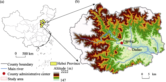
Figure 1 Location of Fuping County (a) and the study area (b) in China
The study area, Dadao Village, is located 7 km southeast of Fuping (Figure 1b). There were 304.76 ha of unused grassy slope land, accounting for nearly two-thirds (62.92%) of the total area in Dadao. However, the average original arable land was no more than 1 mu per capita. According to the Fuping’s Land Consolidation and Comprehensive Agricultural Development Plan, Dadao is one of the first villages in Fuping to carry out land consolidation projects on barren hilly land (started in July 2015, and completed by October 2016). Also, all the barren hilly land in Dadao was included in the land consolidation planning range. Moreover, Dadao is a typical poverty-stricken village, with 497 households and 1,308 permanent residents. Of those totals, 327 households and 673 persons in the village were registered as poverty-stricken since 2014. Therefore, the study area was selected to accurately represent the typical characteristics of Fuping (such as deep poverty, abundant mountain resources and a shortage of arable land).

2.2 Data sources

By employing random sampling and sequential interviewing (Small, 2009), this study conducted questionnaire-type surveys of famers who have been involved in land consolidation in Dadao. The site investigation started in August 2015 (before land consolidation). The investigation mainly took the form of interviews with farmers, the community-level first secretary, poverty relief team leaders, and the manager and staff of the agricultural company. Thus, when the decision was made to carry out week-long questionnaire surveys in May 2018 (after land consolidation), the authors had already formed a rudimentary knowledge of the study area, which helped them to better identify the accuracy of the questionnaires’ feedback information. With the first-hand data obtained by site investigation, the authors tried to analyze the socioeconomic benefits of land consolidation from the perspective of the local farmers. Then, the LUCC that occurred before, during and after land consolidation were interpreted, in order to analyze the corresponding eco-environmental impacts over the years covered by this study.

2.3 Methods

2.3.1 Theoretical framework of BHLC effects analysis
In Fuping’s BHLC model, the village committee serves as a coordinator between farmers and the company. This committee organizes farmers to vote on every major decision regarding land consolidation. After signing a contract with the village committee, the agricultural company is given independent land management rights for 50 years. Meanwhile, the company (as the land user) must farm the land and cannot use it for other purposes (Liu et al., 2016). Local governments dominate the formulation of land consolidation planning, and invites qualified enterprises (which are usually professional agricultural companies) to implement the planning. There are land use policies that give priority to poverty-stricken counties like Fuping. These policies state that, in state-designated and province-designated impoverished counties, the index of the requisition-compensation balance of arable land can be exchanged within the same province(1 This regulation was cited from the document No. 41, released by the Ministry of Land and Resources of the PRC in April, 2017.). Through land consolidation measures, local governments can obtain a considerable amount of financial income to promote county development.
Farmers are the main body and direct beneficiaries of land consolidation practices in rural China. Nevertheless, few studies have evaluated the effects of rural land consolidation from the perspective of farmers. In previous research, the most commonly-used evaluation indexes focused on the land itself. These evaluation indexes included the production capacity of land, the rate of investment return per unit area, the improvement of farmland infrastructure, and the landscape fragmentation rate (Li et al., 2006; Huang et al., 2012; Yang et al., 2013; Zhang and Gao, 2017). To further explore the socioeconomic effects and eco-environmental impacts of land consolidation on local farmers, this study formulates the following five hypotheses based on site investigation works (Figure 2):
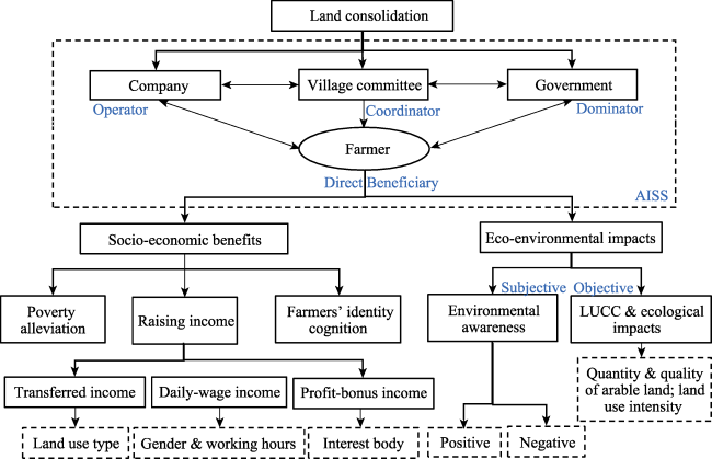
Figure 2 Theoretical framework of barren hilly land consolidation effects analysis
Notes: 1) Further explanation of the “three incomes”: the transferred land circulation compensation was paid according to the original usages of unconsolidated land, and by discounting the yield of a cornfield with an equal area(1 The irrigated land is valued at 6000 kg of corn per ha; the arid land is valued at 4500 kg of corn per ha; the jujube forest land is valued at 6000 kg of corn per ha for the first four years and 4500 kg of corn per ha from the fifth year on.). 2) The agricultural company hired local farmers to cultivate the newly-developed arable land, and the daily wage-income of a male laborer is 80 yuan. Female laborers were paid 60 yuan each day, per person. 3) The third type of income is the share of profit-bonus with the agricultural company. From the fifth year, farmers who have obtained transferred-income shall further receive a corresponding 30% split of profit-bonus with the agricultural company(2 The profits for distribution are the net gross income every year (excluding the operation and management costs, regulation fees and taxes) from the newly-developed arable land. From the fifth to the seventh year, the share of profit-bonus shall not be less than 9000 yuan per ha, and after the eighth year no less than 12,000 yuan per ha. If the profits cannot meet the minimum standards, the agricultural company shall make up the shortfall.).
1) Land consolidation, as one of the primary policies designed to help people escape from poverty in the study area, has effectively reduced poverty headcount ratio (the proportion of the poverty-stricken population to the total population). 2) Farmers are now benefiting from “three incomes” (i.e., the transferred-income of land circulation, the wage-income from land consolidation, and the profit-bonus income with the agricultural company), which has brought significant changes to this area’s family income structure. 3) Farmers are involved in land consolidation in various ways, and their identity cognition has gradually changed from being bystanders to becoming decision makers and supervisors. 4) Local farmers have the most intuitive feelings regarding the environmental changes that occur in the study area after land consolidation, and both the farmers’ positive and negative perceptions do help in the analysis of the eco-environmental impacts of land consolidation. 5) Land consolidation is known to be one of the most important driving forces behind the LUCC, and it inevitably results in certain influences on ecosystem services (such as regulating the regional climate, improving soil productivity, and increasing vegetation coverage) (Yu et al., 2011; Wang et al., 2015; Liu et al., 2018). The above five hypotheses will be respectively verified from the following aspects: poverty alleviation, income structure, farmers’ identity cognition and environmental awareness, and the LUCC and its ecological impacts.
2.3.2 Questionnaire surveys and face-to-face interviews
The contents of the questionnaires include the general information of each household (family size, age, gender, education level, area and structures of land, etc.), farmers’ participation in the land consolidation process (structure of “three incomes”, frequency of attendance, participation in construction, etc.), as well as the changes in farmers’ identity cognition (knowledge of land consolidation, reasons for participation, availability of information, degree of concern for and recognition of land consolidation, etc.).
In Dadao, 299 households are involved in land consolidation. In sample surveys, with such a small sample size (a population below 1,000), more respondents are needed, so a sampling rate of no less than 30% is required (Shao, 2012). In addition, face-to-face surveys can increase the rate of answers to questions and reduce bias in sampling or responses (Czaja and Blair, 2005). Farmers were randomly selected from the list of all the householders involved in land consolidation provided by the village committee (299 households), and the identity information of each interviewee was verified through their ID card. Phone contacts were necessary if the householder was not at home, to ensure the reliability of data. Eventually, 100 of the 299 households were interviewed, with 98 (98.0%) valid questionnaires obtained. The sampling fraction is 32.78%, which covers an age range from 20s to 80s and effectively represents the beneficiaries.
2.3.3 LUCC and land use intensity
This study attempts to intuitively display the LUCC through the interpretation of high-resolution remote sensing data. The actual boundary of the administrative village has been amended, with the aid of field investigation and based on the oral testimonies and conventional landmarks or boundary lines (e.g., a row of poplar trees between adjacent villages) provided by the elderly villagers. Thus, there might be a deviation of the interpreted area from the village’s rough statistics, but this study’s version is closer to the truth. To ensure the continuity and comparability of image data, we selected remote sensing images from Google Earth that cover three periods in the same month in three different years, namely: 2014-08-10, 2015-08-27, and 2016-08-26.
Land use intensity has a positive relationship with eco-supplying and eco-cultural services, while the relationship is negative for eco-regulating and eco-supporting services (Shi et al., 2010). In this study, we adopted the index of land use intensity to measure the impacts of LUCC on eco-environment. The formula is:
$I=\sum \limits_{i=1}^{n}{\left( {{G}_{i}}\times {{P}_{i}} \right)\times}$ 100% (1)
where I refers to the intensity of LUCC, Gi denotes the intensity grade of land use type i, Pi represents the area proportion of type i, and n is the number of land use types. Here, n is 7. The higher the intensity grade is, the higher will be the degree of human interference to the natural surroundings. Based on previous studies (Huang et al., 2011), six grades of land use intensity were set in the study area, namely: 1 for the water area, 2 for the flood plain, 3 for the forest land, 4 for both the existing arable land and newly-developed arable land, and 5 for rural construction land. The unused slope land (with basically native grassland and a few areas of wild forest, as well as several intercrops), which has a land use intensity situated between the forest land and the arable land, was valued at 3.5.

3 Results and analysis

3.1 General information of the respondents

Statistics from the questionnaire surveys (Table 1) show that the average age of respondents was 57 years, with the oldest being 79 and the youngest 27. Among all the respondents, only 12.24% were aged 40 or below, while 42.86% were aged 40 to 60, and the other 44.90% were more than 60 years old. The average number of permanent residents in each household is 2.82 persons, while the average number of persons capable of work in each household was 1.82 persons. A total of 89.80% of the respondents have finished education of no more than middle school level, and only three of the interviewees have ever received a college education. Therefore, it was apparent that most of permanent residents in the village were the middle-aged and elderly, who were not well educated and who had only limited labor skills.
Table 1 Descriptive statistics of interviewees’ general information in Dadao Village, Fuping County in May 2018
General information Sample size Explanation and choices Min Max Mean
Age 98 The real age (not China’s nominal age) 27 79 57
Gender 98 Male=50, Female=48
Education level 98 No more than primary school=40
Middle school=48 High school=7
College and above=3
Permanent residents 98 Population that stays at home for more than 6
months throughout the year
0 8 2.82
Population of working ages 98 16-64 years old, except those incapable of work 0 4 1.82
Usage of the land at pre-consolidation stage1 98 Farm by themselves=86
Left unused=11
Other=2
Area of household transferred land 94 Land transferred for land consolidation
Unit: mu (1 mu equals 0.067 ha)
0.22 25 3.55
Transferred-income of land circulation 94 Unit: yuan / annum 176 2000 2843
Attendance days2 20 Days of work on the newly-developed
arable land in one year; unit: day
7 464 167
Wage-income from land consolidation 20 Unit: yuan / annum 420 39320 12847

Notes: 1) This was a multiple-choices question. 2) The attendance days of a farmer in one year may be more than 365, because some of the work was done in the evening, and the extra time was converted into daytime attendance.

3.2 Socioeconomic effects of land consolidation

3.2.1 Poverty alleviation by land consolidation
The lack of arable land is one of the main causes of poverty in remote mountainous villages such as Dadao. According to the village’s poverty alleviation and development plan, land consolidation has become the first step and primary path to escape from poverty. Moreover, land consolidation has brought about considerable income gains for poverty-stricken families, who were given priority to work for the agricultural company. In this paper, LTF refers to farmers who receive transferred-income of land circulation; DWF refers to farmers who receive wage-income from land consolidation. Statistics show that 239 LTF (79.93%) and 84 DWF (88.42%), who are involved in land consolidation in the study area, belong to poverty-stricken families. Of the farmers who have obtained two or more types of the “three incomes”, 39 of the 41 have been registered as living in poverty-stricken households since 2014.
According to the data from interviews and questionnaire surveys (Figure 3), the number of households that were able to shake off poverty increased from 38 to 320, with 778 people escaping from poverty during 2014 and 2017. Meanwhile, the number of people remain stuck in poverty reduced from 801 to 216, and the poverty headcount ratio decreased from 61.24% to 16.51%; the average income per capita increased from 2780 yuan to 3027 yuan per annum. However, despite the existing results of poverty alleviation through land consolidation, there were 118 households and 216 people still stuck in poverty at the end of 2017, in the study area. Through face-to-face interviews, it was found that elderly farmers who are incapable of manual work shall share the transferred-income from land circulation with their children, after household division and land blocks separation. This may discount the actual benefits of land consolidation. That’s also probably one of the reasons elderly respondents expressed more negative feelings when they were asked about the changes land consolidation has brought about to their livelihoods. Although land consolidation is an effective poverty alleviation measure in poverty-stricken regions with abundant reserve arable land resources, the indications from this study are that the role of a single agricultural-industry based on land consolidation has failed to work as well as has been planned in the short term.
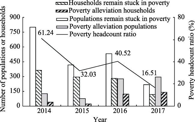
Figure 3 Effects of poverty alleviation in Dadao Village, Fuping County from 2014 to 201
Note: Owing to the launch of the dynamic identification mechanism at the end of 2016, there was a slight increase in the amount and availability of poverty data in 2016.
3.2.2 The “three incomes” of farmers
The original financial statements provided by the agricultural company and the village committee showed that farmers from 299 households have obtained the transferred-income in the past three years, with an annual average of 2843 yuan each household (Figure 4a). A total of 177 farmers employed by the agricultural company in 2017 were from nearby villages. Of these 95 are from Dadao Village. These farmers have earned an average wage-income of 9871 yuan per annum (Figure 4b). To verify the authenticity of these official statistics, a further verification of the respondents’ “three incomes” during the last year was sought in the questionnaire. It was reported that 74 of the 99 respondents are benefiting from land circulation (Figure 4c), and 20 of the 99 respondents had been hired by the agricultural company (Figure 4d). That figure accounts for a proportion of no less than one-fifth of all the beneficiaries. According to the statistics obtained through site investigation, the average transferred-income of the respondents was 3625 yuan per annum, and the wage-income per capita from land consolidation was 12,847 yuan. It was suggested that farmers have indeed gained considerable economic benefits from land consolidation, and the amount of the “three incomes” varies with age.
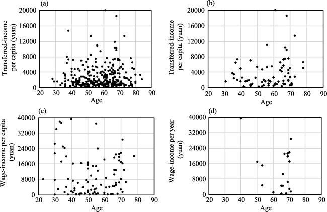
Figure 4 Transferred-income (a, b) and wage-income (c, d) of farmers in Dadao Village, Fuping County in 2017
Note: The data of (a) and (c) originated from the financial statements of the village committee and the agricultural company, and the data of (b) and (d) are the statistics from the site investigation.
Though there was no significant linear correlation relationship between the ages and the “three incomes” of respondents, the above figure does show that the younger employees earned more than the elderly in terms of wage-income, with the highest DWF aged from 30 to 40 years. Meanwhile, the elderly famers gained more transferred-income of land circulation than the younger, with the maximum LTF mainly aged from 60 to 70 years. This is probably because young farmers are capable of more kinds of agricultural work, and their wage-income is proportional to the time invested. Meanwhile, old farmers own more land before household division and land blocks separation, and their transferred-income is proportional to the area of land.
The average age of DWF respondents is 64 years, which is much higher than the average age of LTF respondents (57 years). Income structures (Table 2) show that farmers with the largest proportion of both transferred-income and wage-income are between 60 and 70 years old. Also, 72.97% of the LTF are no less than 50 years old, and of that total, 37.84% are in their 60s or 70s. In addition, 95% of the DWF are 50 or older, and of that total, 55% are 60 to 70 years old. Farmers who gained a transferred-income below 3000 yuan every year made up 60.81% of the respondent group, while only 6.76% gained 10,000 yuan per annum or more. Also, 60% of the DWF had more than 5000 yuan per annum wage-income, of whom 55% earned no less than 10,000 yuan per year. It was suggested that more than half of the LTF and DWF are farmers over 50 years of age, and the latter seemed to earn more than the former.
Table 2 Proportions and structures of farmers’ “three incomes” in Dadao Village, Fuping County in 2017
Age (years old) Proportion of farmers (%) Income per year
(yuan)
Proportion of farmers (%)
Transferred-income Wage-income Transferred-income Wage-income
Below 30 0 0 Below 1000 28.38 10.00
30-40 9.46 0 1000-3000 32.43 15.00
40-50 17.57 5.00 3000-5000 10.81 15.00
50-60 21.62 15.00 5000-10,000 21.62 5.00
60-70 37.84 55.00 10,000-20,000 5.41 30.00
70-80 13.51 25.00 20,000-30,000 1.35 20.00
80-90 0 0 Above 30,000 0 5.00
Average age 57 64 Average income 3625.00 12847.40

Note: The sum of proportions is not always exactly 100%, due to the rounding of data.

Land consolidation can promote the employment of surplus rural labor forces as well. This is especially true for the female and aging populations, and this employment can bring about considerable wage-income benefits for a rural family. However, the demand for labor each month is greatly affected by the schedule of agricultural activities and the weather conditions. Little work is available on rainy days or in the slack farming periods. Statistics indicate that the average farmer works approximately 167 days each year, with the highest attendance in March, and the lowest attendance in January. Hence, job opportunities created by the land consolidation in Dadao are facing the dilemma of a shortage and instability of supply.
3.2.3 Changes of farmers’ identity cognition
This study’s site investigation process discovered the enhancement of famers’ personal identity cognition. Whether for personal benefit or for better participation, famers have tried to understand land consolidation through various channels. At the beginning, land consolidation was something with which local farmers were unfamiliar, and 41.84% of respondents said they did not know anything about it. Another 29.59% had only heard of land consolidation, and a mere 13.27% of respondents thought they had good knowledge of the upcoming land consolidation work (Figure 5a). Moreover, at the pre-stage of land consolidation, nearly two-thirds (64.89%) of the respondents did not have any independent consciousness on decision-making about land consolidation. These people became involved in land consolidation due to a herd mentality (Figure 5b). When it comes to the post-stage of land consolidation, more than half of the respondents (55.37%) enhanced their knowledge of land consolidation, mainly through publicity from the village committee or village cadres (Figure 5c).
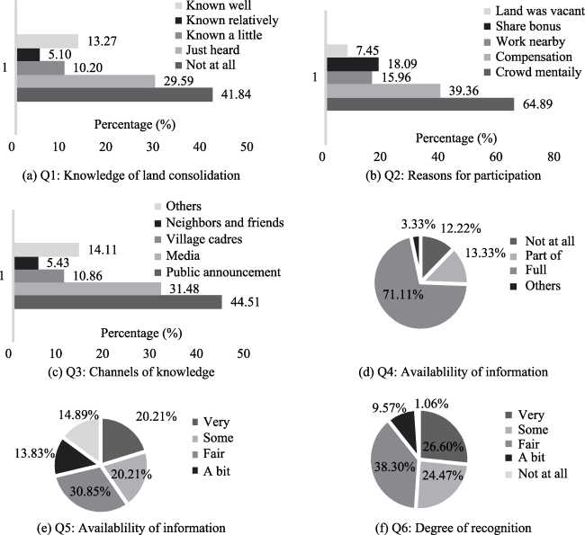
Figure 5 Statistical results of questions concerning the changes of farmers’ identity cognition
Note: Some of the questions are multiple-choice, and the percentages of choices are calculated based on frequency. Thus, the sums of percentages are not always equal to 100.
During the process of land consolidation, farmers’ attitudes towards land consolidation have shifted, from “not caring” to “have great concern.” In interviews, 71.11% of the respondents said the information concerning land consolidation was relatively open, and they could have full access to this information. Another 13.33% of the respondents thought the information was partially open (Figure 5d). However, approximately four-fifths (79.79%) of the respondents also admitted that, even though the information was completely open to them, they did not concern themselves about land consolidation too much. Those who were very concerned about land consolidation under construction only account for 20.21% of the respondents, while 14.89% said they did not concern themselves about it at all (Figure 5e). After land consolidation, most of the respondents (89.36%) appreciated land consolidation in the village, and 26.60% are particularly satisfied (Figure 5f). Also, 68.97% of all respondents expressed their confidence in the future operation and development of land consolidation. Therefore, the third hypothesis above has been proved. Farmers in Dadao have broadened their ways of participating in the different stages of land consolidation. They have also enhanced their sense of responsibility, through measuring land area at the pre-consolidation stage, voting for every decision that needed to be made in the process, and participating in later management, at the post-consolidation stage.

3.3 Eco-environmental impacts of land consolidation

To visually display the LUCC before, during and after land consolidation in the study area, three periods of thematic land use maps have been drawn, and corresponding field photographs have been attached (Figure 6).
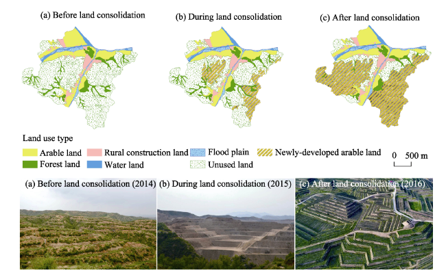
Figure 6 The LUCC in Dadao Village, Fuping County before (a), during (b) and after (c) land consolidation
Note: The above photographs were taken by Zhao S. Y.
As can be seen in the LUCC statistical table for the last three years (Table 3), at the pre-consolidation stage, 62.92% of the land in Dadao was comprised of unused barren hilly land (304.76 ha). The amount of arable land was 83.73 ha, with an average area of 0.06 ha per capita. Meanwhile, the average arable area for all of China was 0.10 ha per capita in 2014, or 1.5 times that of Dadao. During land consolidation, the LUCC data indicated that the unused slope land and open forest land within the planning range were gradually being changed into newly-developed arable land. When it came to the post-consolidation stage, the biggest transformation of LUCC occurred in the unused land. There were 224.41 ha of unused barren hilly land and 17.71 ha of open forest land that had been changed into newly-developed arable land, representing an increase of 0.19 ha of arable land per capita. According to the questionnaire surveys, 90.53% of the respondents used to plant jujube trees on the barren hilly land, and each household has gained an average income of 2427 yuan per annum by selling jujube fruits. However, the unit price of jujube fruits has been quite volatile over the last five years, varying in price from 0.4 yuan/kg to 2.0 yuan/kg. Consequently, most of the land was left abandoned and returned once again to a state of barren hilly land. After consolidation, all the newly-developed arable land has passed the county-level acceptance standard of well-facilitated farmland( The width of each field shall not be less than 6 m, and the area of a single block shall not be less than 0.5 mu (1 mu equals 0.067 ha). The thickness of the active soil layer shall not be less than 1.2 m, among which the thickness of cultivated horizon shall not be less than 0.5 m, etc.). According to the manager of the agricultural company, the newly-developed arable land was mainly planted with high-yielding pear trees, as well as some grape vines, cherry trees, medical herbs and other vegetation. These will not only bring about a considerable amount of economic profit from the fourth year on, but these crops will also create more job opportunities for residents.
Table 3 The total amount and structures of LUCC of three periods in Dadao Village, Fuping County
Land utilization types Unit 2014 2015 2016 Change of proportion (%)
Arable land1 Area (ha) 83.73 83.24 82.97 -0.16
Proportion (%) 17.29 17.19 17.13
Forest land Area (ha) 38.61 38.61 20.90 -3.66
Proportion (%) 7.97 7.97 4.31
Rural construction land Area (ha) 27.16 27.69 28.03 0.18
Proportion (%) 5.61 5.72 5.79
Water area Area (ha) 10.06 10.06 10.06 0.00
Proportion (%) 2.08 2.08 2.08
Flood plain Area (ha) 20.04 20.02 20.02 -0.01
Proportion (%) 4.14 4.13 4.13
Unused grassy slope land Area (ha) 304.76 233.35 80.35 -46.33
Proportion (%) 62.92 48.18 16.59
Newly-developed arable land2 Area (ha) 0.00 71.40 242.04 49.97
Proportion (%) 0.00 14.74 49.97
Total area Area (ha) 484.37 484.37 484.37 0.00
Index of land use intensity (%) 351.67 359.16 378.68 27.01

Notes: 1) The term “arable land” here is used to represent the original arable land in the village, which already existed before land consolidation. 2) The “newly-developed arable land” specifically refers to the arable land added by barren hilly land consolidation, which includes arable land and agricultural facilitated land (roads, reservoirs, drains, etc.).

The index of land use intensity increased from 351.67% to 378.68% during 2014-2016, representing a 27.01% growth rate. Such short-term and high-intensity land use change has even far exceeded the changes of China’s rapid-urbanization areas over the past 20 years (Shi et al., 2010). However, the influence of LUCC on the ecosystem services takes time before becoming apparent, and these influences could not be detected in such a short term. Thus, we tried to further understand the eco-environmental changes occurring in Dadao through the interviewees’ most intuitive feelings, and 96.81% of the respondents believed that land consolidation has changed the landscape in the village. Of that figure, 6.67% thought the changes were significant. These changes are perceived as both positive and negative. The positive aspects are mainly reflected in the greening of barren hilly land, the flattening of slope land, and the beautifying of the environment. The negative side, on the other hand, is reflected in the destroying of original natural vegetation, increased dust floating in the air, the burying of old jujube trees, over-pumping of groundwater, and the potential risks of landslides. All these comments from local farmers regarding environmental awareness will help prevent future negative eco-environmental impacts caused by land consolidation.

4 Conclusions and discussion

4.1 Conclusions

(1) The barren hilly land consolidation can promote the transformation of resource-advantages into asset-advantages in such poverty-stricken areas (with abundant unused land resources) like Dadao. Farmers who are participating in land consolidation in the study area are benefiting from three types of income, i.e. the transferred income of land circulation, the wage income from land consolidation and profit-bonus income with the enterprise. In 2017, 60.16% households in the village gained the additional transferred-income, and 19.11% households received the wage-income. However, the annual average wage income is 9871 yuan, which is much higher than the average transferred-income (2843 yuan). The average age of the LTF is 57 years, which is much younger than the average age of DWF (64 years). Thus, the structure of the “three incomes” varies with age and may have failed to provide farmers with the expected quantity of universal economic benefits.
(2) Land consolidation could inspire farmers’ enthusiasm to participate in village government and help alleviate rural poverty. At the beginning, nearly two-thirds (64.89%) of the respondents did not have any independent consciousness on decision-making about land consolidation, and 79.79% of the interviewees did not concern themselves about land consolidation too much. When it comes to the post-stage of land consolidation, more than half of the respondents (55.37%) enhanced their knowledge of land consolidation, and 68.97% of the interviewees expressed their confidence in the future operation and development of the BHLC model. Therefore, farmers’ attitudes towards land consolidation have shifted from “not caring” to “have great concern”. Farmers’ identity cognition has also gradually changed from being “bystanders” to becoming “decision makers” and “supervisors”. Additionally, during 2014-2017, land consolidation has effectively reduced the poverty headcount ratio of the village from 61.24% to 16.51%, and helped 585 people shake off poverty.
(3) Land consolidation could not only increase the quantity and quality of arable land, but also have a certain impact on eco-environment. From 2014 to 2016, the BHLC model in the study area transformed 224.41 ha unused barren hilly land and 17.71 ha open forest land into arable land. As a result, the average arable land of the villager increased from 0.06 ha per capita to 0.25 ha per capita. All the newly-developed arable land was covered with a thick cultivated horizon (at least 0.5m), and has passed the county-level acceptance standard of well-facilitated farmland. Meanwhile, the index of land use intensity increased from 351.67% to 378.68%, due to land consolidation. Farmers’ perceptions of environmental awareness confirmed that such short-term and high-intensity LUCC are significant enough to make two-side impacts on eco-environment. Some 96.81% of the respondents believed that the BHLC has changed local environment, and of that figure, 6.67% thought the changes were significant.

4.2 Discussion

Most land consolidation efforts in China are government-led, while the masses are usually involved in relatively simple forms of public participation during the process (Luo et al., 2013). Moreover, our study indicates that farmers’ lack of master consciousness during the land consolidation process tended to display a herd mentality with regard to major decisions, which has discounted their real engagement in land consolidation. Therefore, we appeal to establish a combined organization and encouragement mechanism of rural land consolidation, and take the full breadth and depth of farmers’ participation into consideration. Local governments are expected to carry out various forms of professional technology training and publicity work, so as to motivate farmers’ sense of initiative and responsibility.
Land consolidation works as a valid external policy intervention in rural revitalization and has strongly stimulated the vitality of “population, land, industry and capital”, the key elements in China’s rural territorial system (Long et al., 2018). However, our study also demonstrated that rural land consolidation is still in an experimental phase, and overly depends on policy preferences and financial subsidies from local governments. The improper development and consolidation of land resources is also likely to cause the widely known “resource curse” issue, especially in poverty-stricken regions (Li et al., 2016). Thus, we suggest that land consolidation in the new era should not blindly pursue short-term interests, and need more scientific and sustainable planning. Additionally, agricultural industries on the newly-developed arable land urgently requires the planting of high added-value crops and the provision of stable jobs opportunities, so as to attract the backflow of migrant workers and to inject sustainable vitality into the development of rural society.
The BHLC practices have indeed brought about universal and considerable benefits for farmers, local governments, agricultural companies and village committees. Even though the side influences on the ecosystem of such short-term and high-intensity land use change are not detectable at the moment, the BHLC model is worthy to be learned by other countries, especially for under-developed world to alleviate extreme poverty. At the same time we should note that: (1) rural land consolidation should firstly respect the natural law of rural development and should not be rushed. (2) Full play should be given to the exemplary role of the pilot rural-communities, and efforts should be made to prevent neighboring regions from blindly following and causing irreparable losses. (3) Policies related to ecological compensation for the rapid recovery of vegetation are also in need to accelerate the restoration of vegetation and minimize the impacts on the ecosystem.

The authors have declared that no competing interests exist.

[1]
Adrianna K, Michal L, Robert Het al., 2014. Public perceptions of rural landscapes in land consolidation procedures in Poland.Land Use Policy, 33: 313-319.A high level of fragmentation of farms exists in many parts of Poland, which leads to inefficiency in farm management and a range of logistical problems. Land consolidation is a process that reverses fragmentation by enabling an exchange of plots of equivalent value between participants. The primary aim of land consolidation is to improve spatial and economic conditions for farming by decreasing the number of separate plots that belong to a given farm, adjusting the shape of plots to enable mechanized cultivation of soil, and decreasing the distance between dwellings and cultivated plots. Contemporary consolidation works, performed in compliance with the principles of sustainable development, enable creation of legal and spatial conditions that allow the multifunctional development of rural areas and may be used as an instrument to shape rural landscapes. However, the implicit value of landscape is often not taken into consideration during the plot valuation that is undertaken as part of consolidation procedures. The aim of this research is to determine the perceptions and attitudes toward rural landscape elements held by three groups of landscape users: (i) visitors, (ii) farmers who live in areas that are not subject to landscape consolidation processes and (iii) farmers who are engaged in consolidation processes. The focus group method and the L-sort (Landscape sort) method were used to assess attitudes and perceptions, with particular focus on whether there are the differences between the groups and how the perception of landscape value is influenced by: (i) the land consolidation process itself; (ii) the development of farm tourism; and (iii) European Union policies. The results revealed a traditional pattern of landscape appraisal that is strengthened by a utilitarian approach to the value of land in the consolidation procedure. This pattern has the potential to change due to a developing awareness that optimally shaped landscapes may contribute to attracting visitors and/or allow the landowner to obtain financial support under European Union programs. The paper concludes that the esthetic and cultural value of landscape elements should be taken into consideration when evaluating land during the consolidation procedure.

DOI

[2]
Cay T, Ayten T, Iscan F, 2010. Effects of different land reallocation models on the success of land consolidation projects: Social and economic approaches.Land Use Policy, 27(2): 262-269.One of the most important steps in land consolidation (LC) is the land reallocation work, which has a prominent effect on the LC success. For this reason, land reallocation should be handled carefully. There are interview and block priority-based models for land reallocation. The application of different models may have either positive or negative effects on the success of land consolidation. In this study, the block priority and the interview-based models have been compared for the landholding activities in the project at Adaba village, Ere li District, Konya Province, Turkey. The block priority-based model has been observed to be more successful in terms of number of parcel, parcel size, land reallocation process duration, project cost, and farmer satisfaction.

DOI

[3]
Chen Y, Liu Y, Yang R, 2012. Identification of China’s suitable regions for rural residential land consolidation based on livelihoods transformation.Acta Geographica Sinica, 67(3): 420-427. (in Chinese)

[4]
Czaja R, Blair J, 2005. Designing Surveys: A Guide to Decisions and Procedures. 2nd ed. Thousand Oaks, CA: Sage Publications.

[5]
Demetriou D, Stillwell J, See L, 2012. Land consolidation in Cyprus: Why is an integrated planning and decision support system required?Land Use Policy, 29: 131-142.This paper explores issues of land fragmentation, consolidation and reallocation and argues that a new planning support system for land consolidation is needed in Cyprus because of the long duration of projects, the high operational costs and the conflicts between the stakeholders involved. An Integrated Planning and Decision Support System is proposed that integrates artificial intelligence technologies and multi-criteria decision methods with a geographical information system for use in routine land consolidation planning as well as for undertaking ex ante evaluations of land consolidation projects, as required by the European Union. A framework is provided which shows how the system will contribute to reducing the problems associated with the land consolidation process.

DOI

[6]
Du X, Zhang X, Jin X, 2018. Assessing the effectiveness of land consolidation for improving agricultural productivity in China.Land Use Policy, 70: 360-367.

DOI

[7]
Han J, Liu Y, Zhang Y, 2015. Sand stabilization effect of feldspathic sandstone during the fallow period in Mu Us Sandy Land.Journal of Geographical Sciences, 25(4): 428-436.Depended on the analysis of ground snow situation, soil moisture loss speed and soil structure after planting crops of Mu Us Sandy Land remedied with feldspathic sandstone in the fallow period, it is concluded that feldspathic sandstone mixed with sand improved the sand stabilization in the governance of Mu Us Sandy Land in the fallow period. The sandy land remedied with feldspathic sandstone had big snow coverage, 25%–75% higher than normal sand; soil moisture losses slowed down, and moisture content rose by over 3 times; soil structure had been improved, and water stable aggregate content increased by 6.52%–18.04%; survival rate of protection forest increased to 85%; and ground flatness is less than 1%. The above conditions weakened sand rising conditions of Mu Us Sandy Land in the fallow period and formed two protective layers of snow cover and soil frozen layer under cold weather so as to prevent against wind erosion.

DOI

[8]
Hiironen J, Riekkinen K, 2016. Agricultural impacts and profitability of land consolidations.Land Use Policy, 55: 309-317.

DOI

[9]
Huang H, Wu C, Zhang S, 2012. Benefits analysis and evaluation on land consolidation planning in Heilongjiang Province.Transactions of the CSAE, 28(6): 240-246. (in Chinese)Benefits analysis and evaluation on land consolidation planning is a very important part of land consolidation planning. Based on the concept of benefits analysis and evaluation on land consolidation planning, a three-level system "national target-special-purpose target-index" of analysis and evaluation was established by using analytic hierarchy process (AHP). Statistical forecast method, analogy analysis method and expert investigation method were used to analyze and evaluate on land consolidation planning's benefits of Heilongjiang province. Results indicated that land consolidation planning of Heilongjiang province had extremely significant comprehensive effects on achieving the protection of economics and arable land, implementing the most severe protection policy for cultivated land and the most severe economical utilizing land policy, and promoting the construction of the new socialist countryside and overall planning development of urban and rural. The statistical forecast method, analogy analysis method and expert investigation method could be combined with each other and could be used to benefits analysis of planning. The idea and method proposed in this paper provide a reference for other scholars to study benefits of regional land consolidation planning.

DOI

[10]
Huang J, Cui S, Li Fet al., 2011. The sensitivity of Xiamen’s three industrial sectors to land use changes.Acta Ecologica Sinica, 31(14): 3863-3871. (in Chinese)

[11]
Janus J, Markuszewska I, 2017. Land consolidation: A great need to improve effectiveness: A case study from Poland.Land Use Policy, 65: 143-153.

DOI

[12]
Jiang G, Wang X, Yun Wet al., 2015. A new system will lead to an optimal path of land consolidation spatial management in China.Land use Policy, 42: 27-37.Land consolidation spatial management (LCSM) has a significant influence on optimizing national territory arrangement in China. Constrained by the absence of proper administration and evaluation mechanisms, the current LCSM system is entirely based on the principle of "Spatial Recognition of Reserved Arable Land Resources", which eventually causes the loss of distinct management hierarchy and coordination between land consolidation functions and territorial functions. Aiming at providing an optimal path for LCSM in China, this paper proposes a new principle of "Spatial Coordination Guided by Land Consolidation Function" and establishes a new system consisting of national, provincial, municipal and county-level land consolidation zonings, which comprehensively cover the four key spatial elements of land consolidation (territorial function, land consolidation function, land consolidation potential and land consolidation engineering) by using a factor-combination method. Advantages of this new system are described as follows: (1) it recognizes a top-bottom dependent relationship and control mechanism inside LCSM; (2) it coordinates land consolidation functions with territorial functions to effectively promote regional development; (3) it actualizes multiple land consolidation functions with the support of various land consolidation potentials and engineering means; and (4) it provides specific and explicit guidance on single land consolidation project arrangement and coordinates the spatial arrangements of different regional land consolidation activities. To promote the realization of this new system, some important suggestions are also provided, such as establishing diversified and differentiated land consolidation evaluation systems; granting regions autonomy and flexibility over land consolidation project approval, investment and implement standards; and performing land consolidation with the entire region as a complete consolidation object. (C) 2014 Elsevier Ltd. All rights reserved.

DOI

[13]
Li S, Chen Y, Zhang Cet al., 2014. Study on evaluation progress model in the implementation of land consolidation projects based on multi-temporal high-resolution remote sensing data. China Land Science, 28(3): 83-88. (in Chinese)The purpose of this study is to apply remote sensing monitoring in the implementation of land consolidation projects.In this study the project was monitored for the whole progress by using multi-temporal satellite data,and the project image progress evaluation model was constructed to analyze and grasp the progress of land consolidation projects.Methods employed are documentation,earned value analysis and empirical approach.The results show that the evaluation results were concordant with the real progress of the land consolidation project.The conclusion is that the vector data of land consolidation projects,which was drawn from remote sensing image directly or indirectly,are applicable to monitoring the progress of land consolidation projects.The project image progress evaluation model is applicable to estimate the progress of land consolidation projects,and to find out the factors hinder the progress of land consolidation projects.

[14]
Li Y, Cao Z, Zheng Xet al., 2016. Regional and sustainable approach for target-poverty alleviation and development of China.Bulletin of Chinese Academy of Sciences, 31(3): 279-288. (in Chinese)At present,there are still more than 70 million impoverished people in China. The transformation development of poverty-stricken regions and the livelihoods improvement of impoverished rural households are directly related to comprehensive realization the grand goal of building moderately prosperous society in 2020. Based on the analysis of basic geographical conditions,this paper probes the geographical generative mechanism of poverty,and explores the regional model and sustainability approach of targeted poverty alleviation and development. This research suggests poverty generative mechanism and poverty alleviation models are obviously regional particularity,and poverty should be alleviated in the progress of regional transformation development during the 13 th Five Year Plan. This paper also suggests that in order to achieve the goals of targeted poverty alleviation and development,regional policy system,industrial policy system,and land policy system should be further improved,and transmission mechanism between regional development and poverty alleviation should be established and improved as well.

[15]
Li Y, Fan P, Cao Zet al., 2017. Sand-fixation effect and micro-mechanism of remixing soil by Pisha sandstone and sand in the Mu Us Sandy Land, China.Journal of Dessert Research, 37(3): 421-430. (in Chinese)As the core technology and engineering of remixing soil by Pisha sandstone and sand have been presented, there are new ideas and technology supports for rational utilization of land resources and the construction of ecological civilization in a scientific way in the Mu Us Sandy Land. More attention had been paid on technology problems of utilization in previous studies, and remarkable progress had been made. But there still need to strengthen the study of sand-fixation effect and micro-mechanism of remixing soil by Pisha sandstone and sand. This paper aims to exploring the sediment transport volume of typical sand in the Mu Us Sandy Land and remixing farmland and its micro-mechanism based on 8-directional sand collector, scanning electron microscope( SEM) and laser particle size analyzer( LPSA). The results show that:( 1) During the whole observation period, the sediment transport volume of the remixing farmland of Pisha sandstone and original sand was 2 436 g, which was only a half of that of original sand( 4 951 g). This indicated that the remixing farmland of Pisha sandstone and original sand has the function of sand-fixation.( 2) SEM observation showed that soil aggregate began to emerge in the remixing artificial soil, while in the sandy soil, there was still no bond and soil aggregate and the sand particles were fragmental.( 3)LPSA analysis showed that the silt content and clay content only accounted for 2. 74% in sand, while this percentage increased to 15. 12% in remixing artificial soil. So we can infer that the sand stabilization is closely related with soil structure and the silt and clay content in soil. According to the sand-fixing effects of compound soil by mixing sandstone and sand, suitable grass or shrub belt with windproof function should be constructed in the upper regions of dominant wind direction in the first three or four years of projects implementation.

[16]
Li Y, Zhao G, Wang Aet al., 2006. Evaluation index system for land consolidation benefit and its application.Transactions of the CSAE, 22(10): 98-101. (in Chinese)Land consolidation is an important way of coordinating the relationship between people and land and carrying out the aim of farmland protection.According to current research and application of land consolidation benefit evaluation,this paper focused on three aspects of economic,social and ecological benefits of land consolidation and established an evaluation index system,which includes 8 economic indexes,6 social indexes and(8 ecological) indexes.On this basis,the weights of these indexes were reckoned using by AHP analysis method.And the scores of land consolidation project were calculated using by index summation method.This index system was applied to the land consolidation projects at Ningyang County of Shandong Province.That obtained desired results.This research provides a beneficial exploration on quantitative evaluation of land consolidation benefits.

[17]
Liu Y, 2018. Research on the urban-rural integration and rural revitalization in the new era in China.Acta Geographica Sinica, 73(4): 637-650. (in Chinese)Cities and villages are components of a specific organism.Only the sustainable development of two parts can support the prosperous development as a whole.According to the theory of man-earth areal system,urban-rural integrated system and rural regional system are the theoretical bases for entirely recognizing and understanding urban-rural relationship.To handle the increasingly severe problems of "rural disease" in rapid urbanization,accelerating rural revitalization in an all-round way is not only a major strategic plan for promoting the urban-rural integration and rural sustainable development,but also a necessary requirement for solving the issues related to agriculture,rural areas,and rural people in the new era and securing a decisive victory in building a moderately prosperous society in all respects.This study explores the basic theories of urban-rural integration and rural revitalization and analyzes the main problems and causes of rural development in the new era,proposing problem-oriented scientific approaches and frontier research fields of urban-rural integration and rural revitalization in China.Results show that the objects of urban-rural integration and rural revitalization is a regional multi-body system,which mainly includes urban-rural integration,rural complex,village-town organism,and housing-industry symbiosis.Rural revitalization focuses on promoting the reconstruction of urban-rural integration system and constructs a multi-level goal system including urban-rural infrastructure networks,zones of rural development,fields of village-town space and poles of rural revitalization.Currently,the rural development is facing the five problems:high-speed non-agricultural transformation of agriculture production factors,over-fast aging and weakening of rural subjects,increasingly hollowing and abandoning of rural construction land,severe fouling of rural soil and water environment and deep pauperization of rural poverty-stricken areas.The countryside is an important basis for the socioeconomic development in China,and the strategies of urban-rural integration and rural revitalization are complementary.The rural revitalization focuses on establishing the institutional mechanism for integrated urban-rural development and constructs the comprehensive development system of rural regional system,which includes transformation,reconstruction and innovation in accordance with the requirements of thriving businesses,pleasant living environments,social etiquette and civility,effective governance,and prosperity.Geographical research on rural revitalization should focus on the complexity and dynamics of rural regional system and explore new schemes,models and scientific approaches for the construction of villages and towns,which are guided by radical cure of "rural disease",implement the strategy of rural revitalization polarization,construct the evaluation index system and planning system of rural revitalization,thus providing advanced theoretical references for realizing the revitalization of China's rural areas in the new era.

[18]
Liu Y, Fang F, Li Y, 2014. Key issues of land use in China and implications for policy making. Land Use Policy, 40: 6-12.The paper aims to comprehensively analyze key issues of current land use in China. It identifies the major land-use problems when China is undergoing rapid urbanization. Then, the paper interprets and assesses the related land-use policies: requisition-compensation balance of arable land, increasing vs. decreasing balance of urban-rural built land, reserved land system within land requisition, rural land consolidation and economical and intensive land use. The paper finds that current policies are targeting specific problems while being implemented in parallel. There is lacking a framework that incorporates all the policies. The paper finally indicates the current land-use challenges and proposes strategic land-use policy system to guide sustainable land use in the future.

DOI

[19]
Liu Y, Guo Y, Li Y, 2015. GIS-based effect assessment of soil erosion before and after gully land consolidation: A case study of Wangjiagou project region, Loess Plateau.Chinese Geographical Science, 25(2): 137-146.The Loess Plateau is one typical area of serious soil erosion in the world. China has implemented ′Grain for Green′(GFG) project to restore the eco-environment of the Loess Plateau since 1999. With the GFG project subsidy approaching the end, it is concerned that farmers of fewer subsidies may reclaim land again. Thus, ′Gully Land Consolidation Project′(GLCP) was initiated in 2010. The core of the GLCP was to create more land suitable for farming in gullies so as to reduce land reclamation on the slopes which are ecological vulnerable areas. This paper aims to assess the effect of the GLCP on soil erosion problems by studying Wangjiagou project region located in the central part of Anzi valley in the middle of the Loess Plateau, mainly using the revised universal soil loss equation(RUSLE) based on GIS. The findings show that the GLCP can help to reduce soil shipment by 9.87% and it creates more terraces and river-nearby land suitable for farming which account for 27.41% of the whole study area. Thus, it is feasible to implement the GLCP in places below gradient 15°, though the GLCP also intensifies soil erosion in certain places such as field ridge, village land, floodplain, natural grassland, and shrub land. In short, the GLCP develops new generation dam land and balances the short-term and long-term interests to ease the conflicts between economic development and environmental protection. Furthermore, the GLCP and the GFG could also be combined preferably. On the one hand, the GFG improves the ecological environment, which could offer certain safety to the GLCP, on the other hand, the GLCP creates more farmland favorable for farming in gullies instead of land reclamation on the slopes, which could indirectly protect the GFG project.

DOI

[20]
Liu Y, Li Y, 2017a. Revitalize the world’s countryside.Nature, 548(7667): 275-277.

DOI

[21]
Liu Y, Li Y, 2017b. Engineering philosophy and design scheme of gully land consolidation in Loess Plateau.Transactions of the CSAE, 33(10): 1-9. (in Chinese)Loess Plateau used to be the area with the most serious erosion in China even world.Erosion area in Loess Plateau was up to 454 000 km~2,accounting for 70%of the total area in the 1990s.Extremely intensive erosion area with erosion modulus more than 8 000 t/(km~2·a)was up to 85 000 km~2,accounting for 64%of the similar areas in China.Severe erosion area with erosion modulus more than 15 000 t/(km~2·a)was up to 37 000 km~2,accounting for 89%of the similar areas in China.Since 1998,Grain-for-Green Project has been implemented in the Loess Plateau.With the advancement of Grain-for-Green Project,forested land and grassland increase,and farmland decreases.Besides,as the population grows,Grain-for-Green Project has negative effects on grain production in some regions,and the population-grain conflict is intensified.In Yan’an,Shaanxi Province,farmland decreased by 74 000 hm2,grain production decreased by 156 000 t,and per capita grain production decreased by 132 kg with an increase of the residential population of 260 000 compared with those prior to the implementation of the project.With the further intensification of the conflict between population and grain,the demand for new agricultural production space is increasing.After decades of implementing Grain-for-Green,the vegetation cover rate increases and the erosion decreases greatly,which creates preconditions for gully land consolidation.Local initiatives of gully land consolidation since 2012 have achieved initial success.Gully land consolidation creates new space for agricultural and rural development.But how to design and plan the gully land consolidation engineering at a large scale and thus make it be approved by the central government needs systematic thinking and research.Taking Yan’an City,Shaanxi Province as a case study,this paper introduces the basic concepts of the gully land consolidation and its enhanced design in the Loess Plateau.Taking"farmland increasement,ecological protection,people’s livelihood guarantee"as the theme,and"landscape coordination,structure stability,sustainable land use,effective function"as the concepts,the project highlights the land use zoning,which can be described in detail as"returning farmland to forest on the mountain,consolidating gully to farmland in the valley",and put the emphasis on protecting ecological environment and benefiting local residents’livelihood.In the step of planning and design,the zoning,classification standards and key techniques of gully land consolidation are identified,and 4project construction types are proposed,which are restoration-type consolidation,facilities-type consolidation,exploitationtype consolidation,and comprehensive management-type consolidation.Furthermore,the enhanced consolidation technology system is also created,which involves"mainstream-tributary-capillary flow"tiered prevention and control technology,"canal-embankment-dam"matching system,and"tree-shrub-grass"scientific collocation.Since the implementation of the major project of more than 2 years,it has generated economic,social and ecological benefits to some extent.To further exert the project’s comprehensive benefits,the next 4 major projects need be adopted,namely new rural communities and residential resettlement project,urban and rural equalization of services and service facilities engineering,modern agriculture industrialization base construction,and rural land capitalization and land system innovation.

DOI

[22]
Liu Y, Long H, Chen Yet al., 2016. Progress of research on urban-rural transformation and rural development in China in the past decade and future prospects.Journal of Geographical Sciences, 26(8): 1117-1132.Urban-rural transformation and rural development are issues at the forefront of research on the topic of the urban-rural relationship in the field of geography, as well as important practical problems facing China new urbanization and overall planning of urban and rural development. The Center for Regional Agricultural and Rural Development, part of the Institute of Geographic Sciences and Natural Resources Research under the Chinese Academy of Sciences, was established in 2005. The Center has laid solid foundations for integrating research in the areas of agricultural geography and rural development in China over the past decade. The paper aims to review the major achievements in rural geographical research in China during the past decade, analyze innovative developments in relevant theories and methods, and suggest prospects and countermeasures for promoting comprehensive studies of urban-rural transformation and rural geography. The research shows that innovative achievements have been made in rural geography studies of China in the past decade as major national policy development, outputs of result and decision making support; new breakthroughs have been achieved in such major research projects as geographical integrated theory, land remediation projects and technology demonstration projects, new urbanization and urban-rural integration; significant progress has been made in actively expanding the frontiers of rural geography and pushing forward theoretical innovations in land and resource projects; and, with China development goals of building a moderately prosperous society in all respects and achieving modernization in mind, future innovative developments in agricultural and rural geography should aim to make research more strategic, systematic, scientific and security-oriented, with attention given to promoting systematic scientific research on international cooperation and global rural geography.

DOI

[23]
Liu Y, Wang J, Deng X, 2008. Rocky land desertification and its driving forces in the karst areas of rural Guangxi, Southwest China.Journal of Mountain Science, 5(4): 681-699.With a subtropical climate,Guangxi Zhuang Autonomous Region has a typical karst landscape.Rocky desertification has become a serious environmental issue due to its high vulnerability caused by the joint effect of natural settings and human activities,because of which its eco-environment has been deteriorated in recent years,and farmland has been disappearing sharply at the same time.This,in turn,has exacerbated the poverty level in the rural areas of the region.In this study,we monitored the spatial distribution of rocky land desertification and its temporal evolution using Landsat TM/ETM images of 1985,1995,2000 and 2005.We also analyzed the driving forces of the desertification and its expansion.Through constructing regression models by using all the relevant variables and considering the lagged effects as well as fixed effects,we quantified the exact role of different factors causing rocky land desertification in the study area with some new findings.The new findings in this study are greatly helpful for preserving,restoring and reconstructing the degraded mountain environment in Guangxi and other karst areas in Southwest China,and also for alleviating poverty in the rural areas in the future.

DOI

[24]
Liu Y, Wang J, Long H, 2010. Analysis of arable land loss and its impact on rural sustainability in Southern Jiangsu Province of China.Journal of Environmental Management, 91(3): 646-653.

[25]
Liu Y, Zhang Z, Zhou Y, 2018. Efficiency of construction land allocation in China: An econometric analysis of panel data.Land Use Policy, 74: 261-272.The optimal allocation of land resources is an important prerequisite for sustainable land use and for synergic development of regional resources-environment-economy. The question on how to optimize and allocate the regional land resources has become a hotspot in land use and land cover change studies. However, the allocative efficiency of China’s construction land is currently a rather rudimentary and subjective issue. This study used an extended Cobb-Douglas production function to measure the allocative efficiency of construction land at the national and regional levels using balanced provincial panel data from the 1985–2014 period. The results showed that China’s construction land has exhibited a significant increasing trend over the past three decades, and its growth rate in the central region was relatively higher than that in the eastern and western regions. There is little or no available arable land that can be occupied by construction uses in China’s economically developed provinces. Further investigations demonstrated that capital, labor and land investment all contributed to the non-agricultural GDP growth in China. The allocative efficiency of construction land in the eastern region was greater than that in the central and western regions. The efficiency of construction land allocation in China needs to be further improved, and the intensive utilization of land resource is necessary, particularly in the context of China’s “new normal” economy. Because of the regional disparities in the efficiency of construction land allocation, formulating specific region-oriented land use planning may be more urgent. These findings can provide policymakers with a sound basis for land use and urban planning.

DOI

[26]
Liu Z, Müller M, Rommel Jet al., 2016. Community-based agricultural land consolidation and local elites: Survey evidence from China.Journal of Rural Studies, 47: 449-458.61Village level forces of community-based land consolidation are analyzed.61Distance to town, off-farm employment and land endowment affect consolidation.61Local elites can positively improve the consolidation process.61The effect of local elites may change over time.61Local elites shouldn’t be excluded per se, and certain villages targeted in priority.

DOI

[27]
Long H, Tu S, 2017. Rural restructuring: theory, approach and research prospect.Acta Geographica Sinica, 72(4): 563-576. (in Chinese)For the sake of adapting to the changes of elements in both kernel system and external system of rural development, rural restructuring is a process of optimally allocating and efficiently managing the material and non-material elements affecting rural development,reshaping social and economic structures in rural areas and optimizing spatial pattern in rural territory, and approaching the structure optimization and function promotion of rural territorial system as well as the structure coordination and function complementation of urban-rural territorial system. Based on elaborating the concept and connotations of rural restructuring and the mechanism of promoting rural restructuring due to the evolution of "elements-structurefunction", the paper probed the approaches of rural restructuring from the aspects of spatial restructuring, economic restructuring and social restructuring. In order to meet the current national strategic demands and meet the challenges of rural development in the process of urban-rural development transformation, it is in great urgency to strengthen the study on the patterns and processes, dynamic mechanism, differentiated development models, rural planning technology systems, strategies and policies for rural development, and the impacts of globalization on China's rural restructuring in the future. Finally, focusing on a series of problems in the implementation of some important government intervention policies, which is aimed at boosting the social and economic development of rural areas in recent years, a critical analysis and discussion is carried out.

DOI

[28]
Long H, Liu Y, Li X, 2010. Building new countryside in China: A geographical perspective. Land Use Policy, 27(2): 457-470.The central government of China recently mapped out an important strategy on “building a new countryside” to overall coordinate urban and rural development and gear up national economic growth. This paper analyzes the potential factors influencing the building of a new countryside in China, and provides a critical discussion of the problems and implications concerning carrying out this campaign, from a geographical perspective. To some extent, regional discrepancies, rural poverty, rural land-use issues and the present international environment are four major potential factors. Our analyses indicated that land consolidation, praised highly by the governments, is not a panacea for China's rural land-use issues concerning building a new countryside, and the key problem is how to reemploy the surplus rural labors and resettle the land-loss farmers. More attentions should be paid to caring for farmers’ future livelihoods in the process of implementing the strategy. The regional measures and policies concerning building a new countryside need to take the obvious regional discrepancies both in physical and socio-economic conditions into account. In a World Trade Organization (WTO) membership environment, efficient land use for non-agricultural economic development, to some extent, needs to be a priority in the eastern region instead of blindly conserving land to maintain food security, part task of which can be shifted to the central region and the northeastern region. More preferential policies should be formulated to reverse the rural brain–drain phenomenon. Based on the analyses and the complexity of China's rural problems, the authors argue that building new countryside in China will be an arduous task and a long road, the target of which is hard to achieve successfully in this century.

DOI

[29]
Long H, Zhang Y, Tu S, 2018. Land consolidation and rural revitalization.Acta Geographica Sinica, 73(10): 1837-1849. (in Chinese)

[30]
Luo M, Zhou T, Zhang L, 2013. A comparative study on public participation in land consolidation between China and Germany.China Land, (5): 59-61. (in Chinese)

[31]
Niels O, 2015. Agreement based land consolidation: In perspective of new modes of governance.Land use policy, 46: 163-177.A comparative study on the performance of new modes of governance in selected Central and Eastern European countries stated the problem that the emergence of new modes of governance in environmental policy is impaired by weak governance capacities in state and civil society and lack of mutual trust among stakeholders (B枚rzel, 2009a). The purpose of this article is to draw attention to agreement based land consolidation for implementation of area based environmental policies. The article contends that land consolidation exclusively based on agreements can cope with capacity constraints in state and civil society and at the same time apply the principles of new modes of governance. The research questions are: (i) how are principles of new modes of governance applied in agreement based land consolidation? (ii) what are the incentives and the technique in agreement based land consolidation? and (iii) what are the capacity building requirements for an agreement based land consolidation approach? The Danish land consolidation procedure is used as an example of an agreement based approach. Transaction technique, planning technique, and incentives are exposed with reference to transaction cost theory. The impact on trust is illuminated with reference to theory on social capital. The wetland projects serve as an example of area based environmental projects and is illustrated by a case. Data, however incomplete, indicate that agreement based land consolidation has been and is used as an important implementation tool in land related environmental policies in Denmark. The article concludes that the agreement based approach displays key features of new modes of governance. The principle of voluntary agreements grants the affected non-state actors a strong position to influence the final policy outcome and they contribute with local knowledge and mediation. The approach avoids conventional enforcement. Agreement based land consolidation is possible but relies on demanding preconditions. The investment in incentives and capacity building can be justified by a broad range of benefits.

DOI

[32]
Pašakarnis G, Maliene V, 2010. Towards sustainable rural development in Central and Eastern Europe: Applying land consolidation.Land Use Policy, 27(2): 545-549.Over the past twenty years, social and economic decline in rural areas has intensified in the Central and Eastern European countries. A precondition for the reversal of this decline is the implementation of new policies in relation to the fundamentals of land ownership and management. In addition to addressing the problems of land ownership fragmentation, these should include measures to improve agricultural production and employment, taxation policy, and legislation to protect land ownership rights, within the context of acknowledging environmental and sustainability considerations. In Europe, the requirement for readjusting unfavourable land fragmentation and promoting the appropriate use of land combining with positive environmental solutions is expected to create new sustainable land management systems. The consolidation of land ownerships may be an effective and active land management instrument which not only addresses the problems of land fragmentation, but also, if applied sensitively, may be an instrument for delivering sustainable rural development in a wider context. The aim of this research is to investigate land consolidation as an essential tool to create sustainable rural areas in Lithuania.

DOI

[33]
Pia J, Rasmus E, Brian Ket al., 2018. Pursuing collective impact: A novel indicator-based approach to assessment of shared measurements when planning for multifunctional land consolidation.Land Use Policy, 73: 102-114.In this paper, we present a theoretical model for adjustment costs and investment utilisation that illustrates their causes and types and shows in which phases of an investment they occur. Furthermore, we develop an empirical framework for analysing the size and the timing of adjustment costs and investment utilisation. We apply this methodology to a large panel data set of Danish pig... [Show full abstract]

DOI

[34]
Say1lan H, 2014. Importance of land consolidation in the sustainable use of Turkey’s rural land resources.Procedia: Social and Behavioral Sciences, 120: 248-256.It is accepted worldwide that one of the most important solution concerning the future of agricultural activities is improvement of rural lands. Today, in agricultural lands in several countries, land consolidation works are performed for the purpose of increasing production and efficiency and accordingly, ensuring perpetuity of cropping. At the same time, land consolidations are used as an effective tool in sustainable rural development plans. Consolidation works were initiated in 1961 in Turkey, but sufficient success could not be achieved. In this study, methods applied and problems encountered in consolidation practices for rural land resources in Turkey were elaborated. At the same time, place and importance of land consolidation in sustainable efficient use of rural land resources were assessed.

DOI

[35]
Shao Z, 2012. The method for determining sample size in a sample survey.Statistics and Decision, (22): 12-14. (in Chinese)

[36]
Shi L, Cui S, Yin Ket al., 2010. The impact of land use/cover change on ecosystem service in Xiamen. Acta Geographica Sinica, 65(6): 708-714. (in Chinese)Through changing ecosystem's internal structure and function,land use/cover change (LUCC) has affected the supply of ecosystem services.Taking Xiamen City in southeastern China as a study area,this paper used a land use intensity model to analyze regional land change processes.Furthermore Xiamen area was divided into three ecosystems:farmland,forests and wetlands,the ecosystem service evaluation model was developed through combining material and value assessment methods;the coupling changes between land systems and ecosystems were used to represent the influences of land use/cover change on natural ecosystems.The results suggested that along with the promotion of land use intensity,the total ecosystem service values increased from 3.48 billion yuan (RMB) in 1987 to 3.90 billion yuan (RMB) in 2007,with supplying and regulating service being main ecosystem service types;land use intensity had positive relationship with supplying and cultural services,while it was negative for regulating and supporting services.

DOI

[37]
Small M L, 2009. ‘How many cases do I need?’ On science and the logic of case selection in field-based research.Ethnography, 10(1): 5-38.This article addresses the issue of knowing when one has researched enough – thoroughly, and without missing anything. The author argues that there is not a mag

DOI

[38]
Yu W, Zang S, Wu Cet al., 2011. Analyzing and modeling land use land cover change (LUCC) in the Daqing city, China. Applied Geography, 31(2): 600-608.During the past decades, land use land cover change (LUCC) has taken place around most Chinese cities at unprecedented rates. During this process, many rural lands, such as forests and wetlands, have transformed to human settlements. Taking Daqing City, Heilongjiang Province, China as the case study area, this paper analyzed the long-term (from 1977 to 2007) land use land cover change, and modeled the change using a system dynamic model. In particular, land use land cover maps in 1977, 1988, 1992, 1996, 2001, and 2007 were derived from Landsat multi-spectral Scanner (MSS) and Thematic Mapper (TM) imagery. Through analyzing the trend of land use land cover change, three groups of driving forces, including land use management, population growth, and economic and social policies, have been identified to model LUCC in the Daqing City. Finally, future land use change scenarios were simulated under three socio-economic policies: 1) current economic growth, 2) rapid economic growth, and 3) sustainable development. Analysis of results suggests that Daqing City has expanded significantly at the cost of forests and wetlands from 1977 to 2007. Moreover, systems dynamic modeling results suggest that three identified groups of driving forces can effectively explain past land use change in the study area. Finally, simulation results indicate that 1) under current and rapid economic growth policies, built-up land in Daqing City increase significantly, while the areas of grassland and wetlands decrease remarkably, and 2) under the sustainable development policy, the conflict between population expansion and land resource shortage can be alleviated to some extent. These results provide an important decision-making reference for land use planning and sustainable development in Daqing City.Research highlights? Daqing city has expanded significantly with the cost of forests and wetlands. ? Systems dynamic models effectively identify the driving forces of land use land cover change. ? Future land use change varies greatly under different economic growth policies.

DOI

[39]
Wang J, Yan S, Guo Yet al., 2015. The effects of land consolidation on the ecological connectivity based on ecosystem service value: A case study of Da’an land consolidation project in Jilin province.Journal of Geographical Sciences, 25(5): 603-616.

DOI

[40]
Wang Y, Liu Y, 2018. Pollution and restructuring strategies of rural ecological environment in China. Progress in Geography, 37(5): 710-717. (in Chinese)城乡发展转型进程中的乡村生态环境问题日益突出,已经影响到乡村的生产发展和居民的日常生活.本文梳理了乡村生态环境污染的来源和特点,并从资源、生产和生活方面提出了乡村生态环境的重构策略.主要结论为:①资源利用不当、生产活动加强和生活方式改变造成的污染是乡村土地污损化、水体污染化和空气污浊化的主要原因;②乡村生态环境污染具有来源分散多样、排放随机不均和治理局部低效的特点;③通过资源利用的高效化、生产过程的清洁化和生活方式的集聚化进行乡村生态环境的重构,最终实现乡村地区生产发展、生活富裕和生态良好的目标.

DOI

[41]
Wang Y, Liu Y, Li Yet al., 2016. The spatio-temporal patterns of urban-rural development transformation in China since 1990. Habitat International, 53: 178-187.61The research comprehensively assesses urban–rural development transformation in China.61The western and northeastern regions of China experienced slower transformation than other regions between 1990 and 2010.61The initial development level and moderate socioeconomic changes lead to coordinated urban–rural development.61Related urban–rural policies aimed at different regional patterns help to reach balanced urban–rural development in transitional China.

DOI

[42]
Wu C, Fei L, Ye Y, 2011. The theoretical perspective, rational paradigm and strategic solution of land consolidation.Economic Geography, 31(10): 1718-1722. (in Chinese)

[43]
Yan J, Xia F, Ma M, 2016. Strategy orientations of transformation development: Land consolidation in the new period of China.China Land Science, 30(2): 3-10. (in Chinese)The purpose of this article is to identify the emerging issues and transformation requirements of land consolidation, to redefine its essence and functions, and then to figure out the strategic orientations of transformation development based on the macroscopic background of national strategy development. Methods of literature review and comparative analysis are applied. The results show that currently, land consolidation is in a new period with transformation requirements. Against the new definition of its essence as "readjustment of human-earth interrelation" and functions as "satisfaction of individuals' improvement requirements in production, life and ecology", ten strategic orientations are put forward in allusion to current problems such as cramped cognitive, low positioning, homogeneous pattern, and lack of innovative concepts, coordination as well as public participation. The conclusion is that land consolidation should be changed from land-only to high-level integration in its position, from quantity-priority to quaternity in its concept, from grain production to landscape protection in its orientation, from land-oriented to people-oriented in its core, from protecting farmland to optimizing production, life and ecology in its target, from single implement to feature generalization in its object, from project-carrying to domain-coordinationin its scale, from homogeneity to differentiation in its pattern, from top-down to up-down in its path, from fiscal burden to multiple modelin its fund.With this ten strategy orientations, land consolidation can be regarded as the powerful gripper and important platform to balance urban-rural development and contribute to the new goal of building a well-off society in an all-round way.

[44]
Yang J, Wang Z, Jin Get al., 2013. Post-benefit evaluation of land consolidation project implementation based on AHP and fuzzy comprehensive evaluation.Recourse and environment in Yangtze Basin, 22(8): 1036-1042. (in Chinese)China is in the nexus of the 12th Five-Year Plan at present.The continuous growth of the total population,the rapid increase of urbanization rate and the consumption level of urban and rural residents cause the demand of the whole society for agricultural products increasing.However,the fact is the shortage of arable land resources,soil contamination,and the ecological degradation,and this will be a serious threat to economic and social sustainable development in China.Land consolidation as a way to promote the scientific and effective allocation of arable land resources,to improve land utilization,to coordinate the relationship between people and land and to ensure the dynamic balance of the total arable land has become the inevitable choice to alleviate the problem.Land consolidation project has conducted more than ten years from the late 1990s in our country.The problems of how effective the land consolidation is,where need to be improved and what kind of direction of the future land consolidation should be will have a direct impact on the development of land consolidation in China.The post benefit evaluation of land consolidation project implementation is an important topic in land consolidation,and a scientific research on the post benefit evaluation of land consolidation project implementation is of great significance for normalizing and guiding land consolidation practice and for realizing scientific decision of land consolidation.Taking land consolidation project in Changyang Tujia Autonomous country,Hubei province as a case,with the related theories as a guide and the basic data of the project area,the evaluation index system that consists of 15 index was established,the landscape benefit was taken as an independent hand to evaluation in order to make some beneficial exploration for the improvement of land consolidation benefit evaluation.Using analytic hierarchy process(AHP) to calculate the weight of every index and the multi-level fuzzy comprehensive evaluation method to establish the evaluation model,the economic benefits,social benefits,ecological benefits,landscape benefit and comprehensive benefit before and after the project were evaluated.The research results show as follows.After the implementation of the land consolidation project,the project area economic benefit evaluation grade improved from grade C to grade B+,and the score from 33.42 points to 84.19 points;social benefit evaluation grade improved from grade C to grade B+,and the score from 33.52 points to 82.08 points;ecological benefit evaluation grade improved from grade C to grade B+,and the score from 34.46 points to 80.50 points;landscape benefit evaluation grade improved from grade C to grade A,and the score from 32.73 points to 89.03 points;comprehensive benefit evaluation grade improved from grade C to grade B+,and the score from 33.70 points to 83.40 points.Therefore,all the benefits had an obvious improvement,but there was still a large room for improvement to social and ecological benefit.In addition,the landscape benefit had great potential,and it should get more attention in the future project and be regarded as one of the important content of the post benefit evaluation of land consolidation project implementation.

[45]
Yun W, 2011. Introduction on Land Consolidation Planning. Beijing: Geology Press. (in Chinese)

[46]
Zhang R, Gao Y, 2017. Classification of comprehensive benefits of land consolidation in Inner Mongolia Autonomous Region based on grey relational analysis. Chinese Journal of Agricultural Resources and Regional Planning, 38(5): 31-40. (in Chinese)

[47]
Zhou Y, Guo Y, Liu Yet al., 2018. Targeted poverty alleviation and land policy innovation: Some practice and policy implications from China.Land Use Policy, 74: 53-65.Poverty is the common challenge faced by the international community. The human society has never ceased to struggle against poverty. China was once the developing country with the largest rural poor population in the world. Facing the decreasing effect of economic input to poverty reduction, land policy innovations could contribute to promoting poverty alleviation, particularly in China, where the defects in policy making is regarded as a major factor in rural poverty. This study explores the institutional innovation of China poverty alleviation since 2013 and further reveals the mechanism behind land policy innovation promoting the targeted poverty alleviation based on a case study of Songjiagou village of Fuping county, Hebei province. We found that the Chinese central government has innovated the mechanism for the TPA to lift the remaining rural poor out of poverty by 2020 as scheduled. Implementing the TPA could confront the labor, capital and land dilemmas. Combined land policy innovations and land engineering with the ex situ poverty alleviation relocation (ESPAR) can help to break the institutional barriers. We argue that land policy innovations and the ESPAR not only contributes to poverty reduction and improve living conditions of the poor, but also needs to guard against its potential risk. These findings can provide policymakers with a sound scientific basis for poverty reduction planning and decisions in China and other poor countries.

DOI

Outlines

/