Rural land engineering and poverty alleviation:Lessons from typical regions in China

  • LIU Yansui , 1, 2 ,
  • WANG Yongsheng , 1, *
Expand
  • 1. Key Laboratory of Regional Sustainable Development Modeling, Institute of Geographic Sciences and Natural Resources Research, CAS, Beijing 100101, China
  • 2. College of Resources and Environment, University of Chinese Academy of Sciences, Beijing 100049, China
*Corresponding author: Wang Yongsheng (1985-), specialized in land consolidation engineering.E-mail:

Author: Liu Yansui (1965-), Professor, specialized in land science, land engineering and urban-rural development.E-mail:

Received date: 2018-07-12

  Accepted date: 2018-12-20

  Online published: 2019-04-19

Supported by

National Key Research and Development Program of China, No.2017YFC0504701

National Natural Science Foundation of China, No.41801174

Copyright

Journal of Geographical Sciences, All Rights Reserved

Abstract

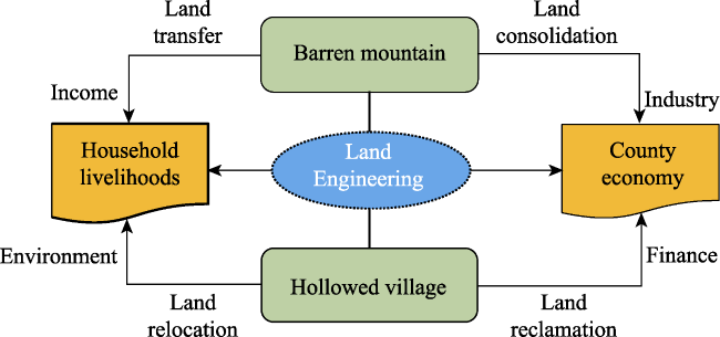
Poverty is a key issue restricting rural sustainable development; concurrently, regional land degradation impedes agricultural development and rural revitalization. China faces severe land degradation and deepening rural poverty under the context of rapid urbanization. To address these challenges, sustainable land use is an important tool in our society’s economic development. Rural engineering, including rural land consolidation, reclamation, restoration, reallocation, improvement, and development, is the most direct and effective way to achieve rural sustainable poverty alleviation. This study clarifies the framework between land engineering and rural poverty alleviation, and introduces land engineering technologies, newly created land utilization practices, and the contributions to poverty alleviation in representative degraded land regions. Land engineering can increase land quantity, improve land quality, enhance land ecological function, and promote man-land system coupling. Further, it can erase rural poverty by increasing county revenue and households’ income, lead to industrial development, and improve living environment. Specifically, degraded sandy land, gully land, hollowed construction land, and barren hilly land are transformed into productive land by improving the land structure. Innovated land engineering technologies and sustainable land utilization modes can provide the basic theories and reference approaches for rural poverty alleviation. Identifying obstacles to effective land and corresponding engineering practices are crucial to regional land exploitation and development, improving quality of life and alleviating rural poverty.

Cite this article

LIU Yansui , WANG Yongsheng . Rural land engineering and poverty alleviation:Lessons from typical regions in China[J]. Journal of Geographical Sciences, 2019 , 29(5) : 643 -657 . DOI: 10.1007/s11442-019-1619-9

1 Introduction

Man-land system is a complex system formed by the interaction between human activities and natural environment in a certain region. The essence of man-land system coupling is to explore the process and state of the integration development of human and natural environment changes, to seek the mechanism and way of coordination and adaptation between the growth of social demand and the carrying capacity of resources and environment, and to realize the dynamic coordination and sustainable development of regional natural-economic-technological system. Therefore, people and land are two important elements of rural areas. Agricultural development and the rural economy depend on the relationships between the regional population and available land in a certain region and its environmental supporting capacity. China is feeding 19% of the global population on less than 7% of the world’s cultivated land. The average cultivated land per capita is only about 0.095 ha, accounting for 27.7% and 12.8% of the world and US averages, respectively. In recent years, China’s intensive man-land relationship has been exacerbated by the rapid urbanization. Various land issues have emerged, such as cultivated land loss, marginalization, abandonment, degradation, and pollution (Liu et al., 2014; Liu et al., 2016; Wang et al., 2016). The “Outline of the Master Plan for China’s Land Use (2006-2020)” presented five issues creating tension in man-land relationships, including inadequate cultivated land reserve resources, decreases in high-quality farmland, extensive construction land, serious regional land degradation and pervasive illegal land use. According to the Land Resources Bulletin in 2015, medium and low level productivity cultivated land areas still accounted for 52.8% and 17.7% of total cultivated land area, respectively (China, 2016). Therefore, identifying and treating various land problems is the basic solution to realizing sustainable agricultural and rural economic development.
Rural poverty is directly related to land resource endowment, quality, and utilization. Poverty-stricken areas are usually correlated with poor man-land relationships. China is classified as an upper middle-income country by the World Bank, and its rapid growth over the last decades has pulled hundreds of millions of its citizens out of poverty. China’s rural poor population has dropped from 250 million in 1978 to 30.46 million in 2017, distributed in 14 contiguous extremely poor regions with a total of 804 poor counties. About 90% of poverty is concentrated in areas in central and western China. These areas characterized by a fragile eco-environment, limited natural resources, and poor land quality, especially in northwest arid, desert, and mountain areas and southwest disaster prone and rocky mountain areas (Liu et al., 2017b). Zhou and Wang (2016) also found that the proportion of land resource-restricted state poverty counties was 24.96% in China. Targeted poverty alleviation from the perspective of man-land relationships was reported in a recent report on China’s contiguous poverty-stricken development report (2016-2017; Ding and Leng, 2018).
Land resource is a cross-cutting enabler of poverty alleviation. Purushotthaman and Abraham (2013) found that agricultural land in poverty alleviation can result in sustained affordable nutritional security. Zhou et al. (2018) reported that innovated land engineering and policy contribute to rural poverty alleviation via land and financial support. Land consolidation engineering provides high-quality farmland to develop modern agriculture (Liu et al., 2018b), land reform supports the national targeted poverty alleviation through “industry integration” and land transfers are beneficial to cultivating new operating organizations, such as family farms, cooperatives and larger enterprises (Wang and Liu, 2018a). Circulating surplus construction land quotas within a province injects new vitality into county economic development (Zhou et al., 2018). Finally, ex-situ poverty alleviation relocation improves poor households’ living environments.
Land quality and its management are more important in industrialized and developing countries characterized by soil degradation, lack of resources, and small landholders (Schjønning et al., 2004). Differentiated land engineering can be applied to solve a variety of land problems, eliminating rural poverty in sandy and karst rocky desertification, salinization, hollowed village, and hilly and gully areas. Liu et al. (2016) described a hierarchical system for rural geography, including the relationships between water-soil, human-land, and urban-rural systems at the micro, meso and macro levels. Subsequently, field observation research on sandy land consolidation engineering and modern agricultural development was conducted at the scale of soil particle to agricultural systems in the Yulin area. Testing land and soil recommendations and land structural consolidation is key to building healthy land and ecological farmland to develop the agricultural industry (Long et al., 2010; Liu et al., 2018b).
Recently, China’s government and research institutes have focused on rural land engineering theory, practice, technology and education. The Key Laboratory of Degraded and Unused Land Consolidation Engineering were established in 2013. The important roles of land engineering technology in improving farmland quality, remediating land degradation, utilizing abandoned land, and repairing the land ecology were emphasized in the strategy for science and technology innovation in land and resource use. In 2016, a new commission of the International Geography Union on Agricultural Geography and Land Engineering (IGU-AGLE) was established in the Institute of Geographic Sciences and Natural Resources Research, Chinese Academy of Sciences. IGU-AGLE targetes the improvement in agricultural conditions and consolidation of degraded land and defiled land using land engineering (Yang et al., 2018). In 2016, the land engineering discipline was established in several universities to cultivate professional talent for national land techonolgy innovation and development.
Land engineering is a complex and systematic engineering discipline with six links, identifying land use obstacles, engineering plan designation, technology integration, field engineering implementation, land ecological protection, and facilities engineering construction (Liu, 2015; Liu, 2018a). Land engineering measures should take fully consider the economy, ecology, and sustainability to avoid higher costs, secondary pollution, and limited availability (Han et al., 2012). In addition, high-efficient utilization of new consolidated land is essential to improving land productivity through crop varietal selection and planting structure optimization. The objective of this study is to clarify the framework between land engineering and rural poverty alleviation, and introduce land engineering technologies, newly created land utilization practices and contributions to poverty alleviation in representative degraded land regions. These findings will provide basic theories and reference approaches to alleviate rural poverty.

2 Framework between land engineering and poverty alleviation

The concept of land engineering was proposed during the “Land engineering senior academic symposium” hosted by the Key Laboratory of Degraded and Unused Land Consolidation Engineering in 2013 (Bai, 2017). Land engineering utilizes engineering measures to coordinate human-land relationship by transforming unused land to available land or efficiently using existing land. The core of land engineering is organic land reconstruction with the objectives of increasing land use range, improving land productivity, and satisfying living organism demands (Han and Zhang, 2014). Liu (2015) defined land engineering as a tool to realize land element structure rationalization, high-efficiency regional patterns, and land use sustainability depending on adaptability and systematic engineering technology. Hu et al. (2017) suggested that the goal of land engineering is to increase land quantity, promote land utilization rate, and land productivity, and improve living and production conditions through consolidation engineering of unused, poor planned, and damaged land (degraded and polluted land). Land engineering practices have been conducted for a long time ago, such as land reclamation in primitive societies, land mergers during the Xia Dynasty, and hydraulic engineering construction during the Qin Dynasty. In modern times, terrace building and saline-alkali soil improvement have played important roles in regional agricultural and rural development. However, these traditional land engineering practices are not suitable for incorporation into complex land problems under current rapid economic development. Pender et al. (2004) suggested location-specific strategies to increase agricultural production and reduce land degradation.
We summarize land engineering system as having three objectives and six modes (Figure 1), which combines nature, economy, and techniques for regional land consolidation, reclamation, restoration, reallocation, improvement, and development according to different problems and objectives (Liu, 2018b). The objectives of land engineering are to increase cultivated land quantity, improve land quality, and enhance land ecological function (Table 1). We also divide the six modes of land engineering into three parts according to these described objectives. First, land consolidation and land development increase land quantity. Degraded land consolidation and reserved land development provide an important pathway for implementing a balanced national cultivated land occupation-compensation policy. Second, land improvement and land reallocation can improve land quality. According to China’s “National Long-term Plan for Food Security (2008-2020)”, the ratio of medium and low productivity cultivated land will decline to about 50% by the end of 2020. Integrated land improvement engineering and cultivated land fertilization measures can enhance land capacity via deepening the plowing layer, improving soil structure, increasing nutrient content and promoting biological function (Shen et al., 2018). Third, land restoration and land reclamation can improve the land eco-environment and realize sustainable land utilization. China released the “Action Plan on Prevention and Control of Soil Pollution” in 2016, wherein polluted land restoration engineering provides technical support for the country’s food security and ecological civilization construction.
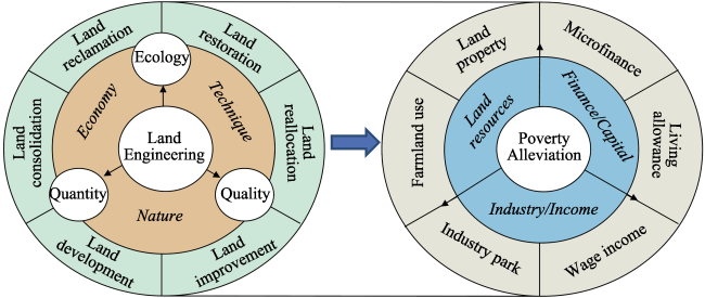
Figure 1 Framework of land engineering and model of the relationship with poverty alleviation
Table 1 Typical land engineering practices in China
Types Practices Objectives
Land consolidation Sandy land comprehensive consolidation. Increase land quantity
Land development Filling gullies to create farmland.
Land improvement High-standard farmland construction. Improve land quality
Land reallocation Three Rights Separation.
Land restoration Polluted and damaged land restoration. Improve land eco-environment
Land reclamation Barren hilly land reclamation.
Land engineering can eradicate rural poverty via three actions. First, land resources can serve as farmland for grain production and are transformed into land property. The surplus quotas on construction land will help increase the collective economy in poor areas through the development of real estate and land revenue (Zhou et al., 2018). Second, newly created land can be used for industrial development, such as for the photovoltaic power generation, agritourism, planting, and animal husbandry industries. The rural poor can have higher wage incomes from participating in industrial development. Third, integrated land engineering with finance or capital provides living allowances for poor households.

3 Case studies of land engineering practices in rural poverty alleviation

The Chinese government will take additional measures to develop modern agriculture in the next five years, according to a plan released by the State Council in 2016. The objective is to build an efficient, environment-friendly, and resource-saving agriculture; improve farmers’ income; and maintain a supply of agricultural products. However, modern agricultural development and agricultural productivity enhancement is limited by high-quality farmland due to land degradation (Pender et al., 2004). The Center for Regional Agricultural and Rural Development (CRARD) at the Institute of Geographic Sciences and Natural Resources Research under the Chinese Academy of Sciences is devoted to rural development, land engineering, and modern agricultural research. CRARD has established four land engineering stations to consolidate degraded sandy land, gully land, hollowed construction, and barren hilly land for sustainable utilization. Innovative land engineering technologies will identify, adapt, and recreate new functions for a sustainable agro-land use system (Ewel, 1999). Therefore, we separately introduce the ideas and practices in land engineering to our four stations. The summarized engineering technology and agricultural development mode will support rural development and poverty alleviation in similar areas.

3.1 Sandy land engineering and modern agricultural development

About 35% of China’s population depends on degraded land (Bai and Dent, 2009). Poverty-stricken counties account for about 38.68% of the total 212 counties with desertified land (Wen, 1992) and land degradation remains the most serve problem facing agricultural production in the Mu Us Sandy Land areas. Households’ livings in poverty have impeded rural economic and social sustainable development such that various engineering measures have been developed to control and develop sandy land. Nevertheless, it is difficult to simultaneously achieve a strong economy, protected ecology, and sustainability in some areas (Liu et al., 2004; Han et al., 2012; Liang et al., 2017). Suitable engineering measures can improve soil, water, air, and biological environments for crop growth.
The Experimental Station for Optimization Engineering of Modern Agriculture was jointly established by the Institute of Geographic Sciences and Natural Resources Research, Chinese Academy of Sciences and Yulin Academy of Agricultural Sciences, Shaanxi Province. At the strategy level, the sustainable utilization of degraded land and sustainable development of modern agriculture are key to achieving ecologically-friendly construction and targeted rural poverty alleviation. At the realistic level, regional degraded land productivity, agricultural operation efficiency, and production activity ecological benefit are key to achieving rural development and revitalization in the Mu Us Sandy Land areas. At the scientific level, coupling land engineering with modern agriculture is key to sowing improved crop varietal on healthy and fertile soils with the purpose of supporting degraded land-oriented consolidation (Figure 2).
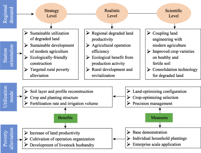
Figure 2 Research framework of experimental station on optimization engineering of modern agriculture
At the Yulin experimental station, sandy land consolidation engineering and modern agricultural development have been coupled from the soil particle to agricultural systems scales. Red clay and loess were applied to improve sandy land structure using “structural consolidation”, land testing and soil recommendation (Liu et al., 2018b). Land-optimizing configuration, crop-optimizing selection and precision management were applied in the field experiments. We first reconstructed the surface soil layer and soil profile based on blending red clay or loess with sand under different volume ratios of 1:1, 1:2, 1:3, and 1:5. Maize, tomato, and soybean were planted in the mixed soils. In addition, pasture planting structures were modified to motivate animal husbandry development using various forage grasses, such as alfalfa, paper mulberry, nepenthes, and rape. Fertigation techniques were used to obtain an optimized fertilization rate and irrigation volume. Sandy land sustainable utilization modes were demonstrated and popularized in individual household plantings and enterprise scale applications. Rural poverty can be reduced based on promoting land productivity, organizing cultivation operations, and developing livestock husbandry. Rent increased from 2250 yuan RMB per hectare of sandy land to 15,000 yuan per hectare of consolidated land. Tomato yield reached 4605 kg ha‒1 in newly created cultivated land, leading to a direct economic efficiency of 9210 yuan per hectare according to the local tomato price of 2 yuan per kilogram (Han et al., 2015). In addition, regional agricultural development was promoted based on constructing modern agriculture demonstration bases. China is one of the most severely desertified and developing countries in the world (Zha and Gao, 1997), thus the consolidation and utilization conducted at our station on sandy land will provide economic and ecological support for local agricultural development and rural poverty alleviation.

3.2 Gully land consolidation and sustainable use

The Loess Plateau (LP) has some of the most serious erosion in China and is the largest source of sediment to the Yellow River. Populations of about 100 million people have exacerbated deforestation and overgrazing, resulting in a deteriorated ecological environment and poorly performing local economies (Shang and Li, 2010). Terracing, check dam and reservoir construction projects have contributed to a declining sediment load from the 1970s to 1990s, while vegetation restoration projects have decreased soil erosion since the 1990s (Wang et al., 2015). The Grain-for-Green Project (GGP) has significantly improved the eco-environment; a clear increase in NDVI (54.99%) on the LP was achieved between 2000 and 2013 (Cao et al., 2017). However, about double the limitation areas for GGP have been converted to forest and grassland between 2000 and 2008 ( et al., 2012), which have resulted in socio-economic problems, such as farmland reduction and food shortages (Figure 3). From 1996 to 2007, the total crop sown area and grain production on the LP declined by 10.10% and 3.76%, respectively (Liu and Li, 2012). The conflict between environmental protection and household livelihood improvement has attracted considerable attention.
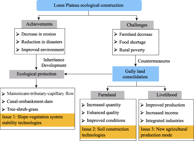
Figure 3 Research framework for gully land consolidation and sustainable land use
Chen et al. (2015) showed that balanced land use and newly created farmland were necessary to avoid further grain shortages and accelerate rural sustainable development. Decreased soil erosion creates preconditions for gully land consolidation. Therefore, gully land management is one mechanism that promotes economic development and ecologically-friendly construction through controlling slopes and, ditches with the goal of subsequently eliminating poverty. Returning farmland to forest on the slope while also consolidating gully to farmland in the valley is beneficial to protecting the eco-environment and improving local resident’ livelihoods. At the end of 2013, the National Key Project for Gully Land Consolidation in Yan’an was approved by the Ministry of Land and Resources and the Ministry of Finance (Liu et al., 2016). The project goal was to create 33,700 ha of farmland from 2013 to 2017 with a total investment of 4.83 billion yuan RMB. Therefore, a systematic engineering design plan was necessary to guide large-scale gully land consolidation.
Based on natural local conditions, existing facilities, and utilization demand, four types of gully land consolidation engineering methods were proposed: restoration, facilities, exploitation and comprehensive management. The gully land consolidation engineering technology system was created to support the gully land consolidation project in Yan’an, involving “mainstream-tributary-capillary flow” tiered prevention and control technology, “canal-embankment-dam” matching system, and “tree-shrub-grass” scientific collocation (Liu and Li, 2017b). Nonetheless, the sustainable and efficient utilization of new consolidated gully land resources has become a prominent problem after filling gullies to create farmland.
The collapsibility and weak shear strength of loess soils results in lower slope stabilityand higher risk of erosion (Zhao, 2014). Newly excavated slopes emerge due to moving soil from slopes to gully channels during gully consolidation engineering. Therefore, the first significant issue addressed at the Yan’an station was slope-vegetation system stability technologies. Three slope degrees (45°, 53° and 63°) and two vegetation types (Caragana microphylla and Amorpha fruticosa) were selected to study the best combination based on monitoring slope stability and vegetation growth. The results showed that a slope of 53° with a mixture of Caragana microphylla and Amorpha fruticosa was most appropriate for slope protection. In addition, Liu (1959) indicated that young loess has a comparatively loose structure and collapsibility relative to old loess. We used this differential micro-structure property of loess to avoid the ecological risk of gully land consolidation engineering. Soil reconstruction experiments were conducted with dry mixtures of young and old loess at volume ratios of 6:0, 5:1, 4:2, 3:3, 2:4, and 0:6. The flat channel-related farmland improved agricultural production condition, which is favorable for mechanized farming and large-scale operation. Newly created gully land has three times the productivity of hilltops and five times the productivity of slopes (Du, 2016). However, traditional annual maize planting limited agricultural modernization and functionality. The optimized planting structure is key to improving land use efficiency and increasing household’ income (Liu et al., 2017a). The increased accumulated temperature ≥ 10℃ on the LP with good soil conditions and sufficient water resources shows great potential for developing new cropping systems with two crops per year (Liu et al., 2019). Hence, we introduced forage into local agricultural production and performed plot experiments with varying planting dates and seeding densities in our station. Forage planting promotes industrial integration and improves the local economy through developing livestock breeding, rape flower tourism, and rapeseed oil processing (Liu et al., 2017a). We established an agritourism project, “Gully Consolidation and Sustainable Land Use on the Loess Plateau” in 2014 with the goal of achieving ecological protection, farmland expansion, and guaranteed resident livelihoods (Figure 3). Local households can be benefited from improved production, living and eco-environment, enhanced grain production, and developed industries.

3.3 Hollowed construction land consolidation engineering

Attracted by higher income, superior public services, cultural facilities and convenient infrastructures in cities, labor has migrated from rural to urban areas in significant numbers. China’s urbanization level rose from 17.91% in 1978 to 57.35% in 2016 (NBSC, 2016). The dual-track structure of rural and urban development has resulted in more complex and aggravated hollowed village problems in China than in any other country (White et al., 2009;Liu et al., 2013; Long, 2014). Hollowed and abandoned residential land brings wasted land resources and decreases in rural living, production, and environment (Liu and Li, 2017a; Wang and Liu, 2018b). Developing hollowed villages has remained limited and is easily marginalized, causing deepening poverty, and posing challenges to China’s rural poverty alleviation strategy. The potential rural land consolidation of hollowed villages will reach 9.92 million ha in 2020 (Liu et al., 2013). Hence, exploring vacant and abandoned housing land reclamation technologies and standards can provide technical and theoretical support for the scientific promotion of China’s comprehensive rural land consolidation. In 2014, we established a research and demonstration base in Yucheng City, Shandong Province, using funding from National Key Technology Program “Key technology research and demonstration of reconstructing hollowed village”. Fixed village observations, homestead identification, and land consolidation have been performed to provide theoretical research and suitable engineering technologies (Figure 4).
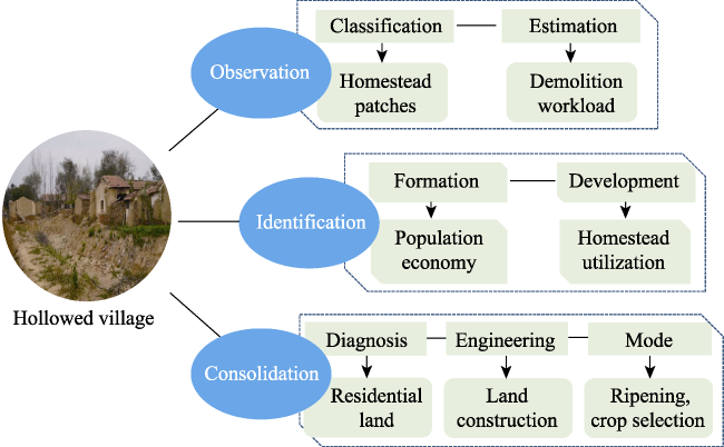
Figure 4 Research framework for hollowed construction land consolidation engineering
To analyze the formation and development trends of hollowed villages’, we observed the population mobility, economic development, public service facilities, and homestead utilization annually in several villages of Yucheng, including Pai Zi, Xing Dian, and Yang Qiao. In addition, we used high resolution remote sensing image to quickly identify homesteads that were empty and obsolete. Hollowed and obsolete homestead demolition workloads were estimated using orthophotography, oblique photography data from unmanned aerial vehicles. However, there are significant differences in characteristics between the defective soil from house bases, clay walls, roads, and courtyards during hollowing village demolition. Li et al. (2018) showed that village roads, house bases, and clay walls are more compacted than that of courtyard soil and woodland topsoil. Hence, reclaiming abandoned construction land and transforming it to well-structured and nutrient-rich cultivated land should include surface soil reconstruction and improved soil fertility (Chang et al., 2017). In our station, we developed methods for identifying defective soil, land engineering, and planting structures to consolidate abandoned construction land (Figure 4). Pot experiments indicated that sediment soil provided a better growth environment for crops than roads and courtyard soil. Healthy land construction engineering was performed to explore key technologies for using various construction waste products and residential land. Three soil profiles, including the basal, compaction, and plowing layers, were filled with thicknesses of 30 cm construction waste, and 35 cm courtyard soil and clay wall, and 35 cm recommended soil mixture from pot experiments. Organic fertilizer and bacterial manure were designed to improve soil fertility.
Hollowed construction land consolidation increases agricultural land area, achieves optimal land allocation for rural-urban land resources, improves land use efficiency, and protects peasant’ land profits (Liu et al., 2013; Long, 2014). Furthermore, it will build new countryside through restructuring rural production, and living and ecological space, including rural infrastructures, public facilities, and a deteriorated eco-environment (Long, 2014; Wang and Liu, 2018b). The collective economy in poor areas can be strengthened through hollowed village consolidation, which balances the urban-rural built-up land policy after changing abandoned residential land into available cultivated land (Liu et al., 2018a; Zhou et al., 2018).

3.4 Barren hilly land consolidation and county development

The Yanshan-Taihang Mountain area is a contiguous poverty-stricken area in China, where in 2014, 1.5 million rural poverty-stricken people resided with a poverty incidence of 16.8% on the 93,000 km2 of land area. Fuping County is a state-designated impoverished county, located east of Taihang Mountain. About 87% of Fuping County is mountainous and per capita cultivated land area is only 0.06 ha (Zhou et al., 2018). However, the per capita unused land area less than 25° (slope degrees) is about 0.15 ha. In addition, there are 435 villages with a population of less than 50 people and 161 villages with no household wage. The major causes of poverty are illness, and lack of technology and capital. Fuping County has pro-actively explored targeted poverty alleviation measurements to promote county economic development and address rural poverty. Land consolidation and ex-situ poverty alleviation relocation plays an important role in lifting the rural poor out of poverty and promoting county economic development (Liu et al., 2018a; Zhou et al., 2018). Abundant reserve land resources provide good opportunities to develop land policy innovation and practice for rural poverty alleviation (Figure 5). Since 2013, the Ministry of Land and Resources has recognized Fuping County for its land policy pilot project, supporting rural poverty alleviation and development using land consolidation, land allocation, requisition-compensation balance, and balancing rural-urban development (Zheng, 2016). The rural poor population has decreased from 0.11 million in 2014 to 28,416 in 2016 and the corresponding poverty incidence has decreased from 54% to 14.8%, respectively.
Figure 5 Research framework for barren hilly land consolidation and county development
Circulating the cross-regional of construction land quota within a province in poverty-stricken areas can transform land resources to capital and assets (Zhou et al., 2018). Fuping County reclaimed idle and abandoned construction land, and then converted it at a price of 9 million yuan RMB per hectare. Fuping County relocated 47,000 households or 144,000 people in the most recent five years. The local government will achieve more than 12 billion yuan RMB in saving from alleviating rural poverty by trading construction land (Zheng, 2016). Moreover, land relocation helps the rural poor living in regions with harsh conditions by improving living, production, and the ecological environment, which alleviates poverty (Wang and Liu, 2018a). Zhou et al. (2018) suggested that ex-situ poverty alleviation relocation can increase farmer’ incomes and improve the regional eco-environment through innovative land policy and engineering. In addition, Fuping County plans to develop the eastern barren hills for farmland through a series of land engineering projects. The expected area of newly developed farmland is 13,333 ha, equivalent to the amount of original farmland in Fuping County. Newly created farmland can improve the county economy through land transfers that develop industries, such as modern agriculture. Farmers can obtain land rent, wages and dividends from land transfers, with annual fees of 12,000 yuan per hectare, 21,600 yuan per hectare, and 15,000 yuan per hectare, respectively (Zhou et al., 2018).

4 Discussion and conclusions

4.1 Discussion

Clear water and lush mountains are invaluable assets. China’s congress has implemented major projects to protect and restore key ecosystems to build a beautiful China and create a favorable living environment for its people. Land engineering is the most direct and effective way to address poverty and achieve sustainable rural poverty alleviation. Creating a balanced man-land system will support agricultural, village, rural, and urban-town system development. Faced with increasingly serious rural development problems, geographical engineering research was first proposed to convert conditions from unfavorable to favorable, better use resources, and productivity. Liu (2015) called for further developing land engineering in China based on better use of theoretical systems, regional diagnosis, techniques, standards, and functioning modes. At present, various land-use problems have drawn much attention from both government and research institution (Liu et al., 2014). Therefore, identifying land use obstacles and corresponding engineering practices to address them are crucial to exploiting and developing regional land, improving household’ livelihoods, and implementing rural anti-poverty measures. In 2016, an international academic seminar on big data and the rise of land engineering discipline was hosted in Xi’an City, Shaanxi Province, with the goals of promoting land engineering as a discipline, and the ecological and sustainable development of land (Lu, 2016).
Activate rural residents, land, and industry are important to reducing poverty and improving well-being in poverty-stricken areas. Land engineering improves production, living, and ecological space and motivates poor households’ endogenous development power. The theory of man-land relationships emphasizes human subjective initiatives in sustainable development (Huang, 1993; Wu, 2008). Land engineering highlights the significant roles of poor households in employment, shareholders, and managers. Ex-situ poverty alleviation relocation must guarantee sources of livelihood for migrants and avoid landlessness or joblessness. Public service, industrial parks, public welfare jobs and individual business premises can truly ensure poverty alleviation and sustainable development from relocation. However, prevalent industrial homogeneity will limit industrial development and reduce household initiatives. Integrating land engineering with land policy can provide financial support to agricultural and rural development in poor areas. Surplus construction land quotas in impoverished areas are transferrable in such programs as the “East-West Pairing-off Regional Cooperation for Poverty Reduction”. In practice, scientifically reasonable land reclamation must conform to demands from poverty relief and long-term development. Land quota trading should prioritize areas with deepening poverty areas by negotiating prices. Currently, China’s government has initiated rural revitalization strategies to offset weakness in the balance between urban and rural development. An alternating three-year period is critical for poverty alleviation and serves as the basis for rural revitalization. Land engineering will play an important role in eliminating rural poverty and building the foundation for rural revitalization.

4.2 Conclusions

Poverty is directly related to land degradation, which impedes rural development and revitalization. Land engineering can balance man-land relationships and promote man-land system coupling by increasing land quantity, improving land quality, and enhancing land ecology. Sandy, gully, hollowed construction, and barren hilly lands can be transformed into productive farmland and farmers’ property income through specific land engineering technologies and optimal land-use allocation.
Practice in many places shows that the model of land engineering poverty alleviation has obvious systematic, strategic and sustainable characteristics, and it has become a very important approach of targeted poverty alleviation in rural areas of China. Land engineering can eliminate rural poverty by leveraging higher from county revenues and household’ incomes, industrial development, and improvements in the living environment improvement. Important aspects of this discipline are identifying land use obstacles and corresponding engineering practices because they are crucial to regional land exploitation and development, improvements in household’ livelihoods, rural anti-poverty measures and revitalization.

The authors have declared that no competing interests exist.

[1]
Bai Hua, 2017. Congratulations to the approval of land consolidation engineering undergraduate major in Chang’an Unviersity. Shaanxi Daily, , 2017-03-23.

[2]
Bai Zhanguo, Dent D, 2009. Recent land degradation and improvement in China.Ambio, 38(3): 150-156.Land degradation is a global development and environment issue that afflicts China more than most countries in terms of the extent, economic impact, and number of people affected. Up-to-date, quantitative information is needed to support policy and action for food and water security, economic development, and environmental integrity. Data for a defined, recent period enable us to distinguish the legacy of historical land degradation from what is happening now. We define land degradation as long-term decline in ecosystem function and productivity and measure it by remote sensing of the normalized difference vegetation index (NDVI), the greenness index. NDVI may be translated to net primary productivity (NPP). Deviation from the norm serves as a proxy assessment of land degradation and improvement-if other factors that may be responsible are taken into account. These other factors include climate, which may be assessed by rain-use efficiency and energy-use efficiency. Analysis of the 23-year Global Inventory Modeling and Mapping Studies (GIMMS) NDVI data reveals that, in China over the period 1981-2003, NPP increased overall, but areas of declining climate-adjusted NPP comprise 23% of the country, mainly in south China. About 35% of China's population (457 million out of 1 317 million) depend on the degrading land. Degrading areas suffered a loss of NPP of 12 kgC ha y , amounting to almost 60 million tC not fixed from the atmosphere; loss of soil organic carbon from these areas is likely to be orders of magnitude greater. There is no correlation between land degradation and dry lands; it is more of an issue in cropland and forest: 21% of degrading land is cropland and 40% is forest, 24% of the arable and 44% of the forest, respectively. There is no simple statistical relationship between land degradation and rural population density or poverty. Most identified land degradation is in the south and east, driven by unprecedented land-use change.

DOI PMID

[3]
Cao Zhi, Li Yurui, Liu Yansui et al., 2017. When and where did the Loess Plateau turn “green”? Analysis of the tendency and breakpoints of the normalized difference vegetation index.Land Degradation & Development, 29: 162-175.Abstract The Loess Plateau experiences the most serious soil erosion problems in China and possibly even globally. Many measures have been taken to increase the vegetation cover and to control soil erosion. Of these measures, the Grain for Green Project, launched in 1999, has been the most effective, changing the ecological and socio-economic situation of the Plateau significantly. Using time series normalized difference vegetation index (NDVI) data from 1981 to 2013, this study analysed spatial patterns of changes in vegetation cover, detected spatial patterns of the abrupt-change time of NDVI trends, and investigated factors that may contribute to these changes. The results showed that (a) vegetation restoration was obvious over the last decades, especially in the 2000s, and the increase in NDVI during 2000–2013 was more than 3-times that during 1990–2000. Approximately 54.99% of the Plateau during 2000–2013 had a statistically significant increase, mainly distributing in loess hilly and gully region and loess gully region. (b) Vegetation restoration was comprehensively affected by climate change and human activities (e.g., the Grain for Green Project, urbanization and policies), and the effects of each factor varied for different regions. (c) Vegetation in most of the Plateau began to increase around 2007–2010, and 4 discrete areas with different timings of such break points were detected. The difference in the timing of break points in NDVI may be related with precipitation, reproducing tree species, management measures, and survival rate. These results imply that integrating natural and human factors is important when making effective and suitable measures and policies.

DOI

[4]
Chang Huanhuan, Su Youbo, Zhang Jiansheng et al., 2017. Reclamation strategy of abandoned construction land in hollowing villages.Journal of Agriculture, 7(6): 34-37. (in Chinese)

DOI

[5]
Chen Yiping, Wang Kaibo, Lin Yishan et al., 2015. Balancing green and grain trade.Nature Geoscience, 8(10): 739-741.Since 1999, China's Grain for Green project has greatly increased the vegetation cover on the Loess Plateau. Now that erosion levels have returned to historic values, vegetation should be maintained but not expanded further as planned.

DOI

[6]
Ministry of Land and Resources of China, 2016. Land Resources Bulletin. Beijing. (in Chinese)

[7]
Ding Jianjun, Leng Zhiming, 2018. Regional poverty analysis in a view of geography science.Acta Geographica Sinica, 73(2): 232-247. (in Chinese)Owing to the multidimensional and spatial nature of poverty and the synthetic and visible analysis merits of geography science, there is a great potential for geography science,which is taking human-environment relationships as core topics, to understand regional poverty and guide the poverty alleviation practices. This article tries to explain the connotation,inscapes, patterns, formation process and countermeasures in a view of geography science based on the retrospect of geographical research on domestic and abroad poverty. The main conclusions showed that:(1) Regional poverty can be considered as a status or process of deprivation on the three dimensions of "human", "activities" and "environment", or the disharmony among them under the specific situation;(2) The inscapes of regional poverty contain subjective factor( "human"), intermediated factor( "activities") and objective factor( "environment"), and the poverty patterns were caused by the deprivation of the three factors or their imbalanced coupling;(3) The formation process of regional poverty patterns can be understood as a nonlinear negative accumulative cycle of disorderly coupling of subjective factor, intermediated factor and objective factor. At the same time, it can be considered as a phenomenon that the subjective factor( "human") and objective factor( "environment") can not catch up or match the changes of intermediated factor( "activities") during the transitions of human civilization;(4) Synthetical poverty alleviation needs targeted interventions as well as coordination of all countermeasures, which is similar to the consultation of doctors in hospital,which may be a good way to achieve the goal.

[8]
Du Xiping, 2016. Report on filling gullies to create farmland to the people’s government of Yan’an. , 2016-09-28. (in Chinese)

[9]
Ewel J J, 1999. Natural systems as models for the design of sustainable systems of land use.Agroforestry Systems, 45(1-3): 1-21.Natural ecosystems, whose components are the results of natural selection, are sustainable; most are productive, responsive to pests, and retentive of nutrients. Thus, they are appropriate models on which to base the design of new systems of land use. Abiotic and biotic stressors are related non-linearly; the nadir of total stress being mid-way along a gradient of environmental harshness. Superimposing the stress functions on Holdridge's life zone chart yields four broad categories of environments for agriculture: climates where annual rainfall is similar to potential evapotranspiration, plus three other categories that are either too cold, too arid, or too wet. Extremely cold lands have no potential for agriculture. Lands that are arid or infertile can be used successfully, although the cost of compensating for environmental limitations increases exponentially with increasing abiotic stress. Grazing animals (which act as trophic buffers between people and environment) have proven successful in dry and infertile environments. The humid tropical lowlands epitomise environments of low abiotic stress but overwhelming biotic intricacy. Here it pays to imitate natural systems rather than struggle to impose simplicity on ecosystems that are inherently complex. The keys to success are to (i) channel productivity into outputs of nutritional and economic importance, (ii) maintain adequate diversity to compensate for losses in a system simple enough to be horticulturally manageable, (iii) manage plants and herbivores to facilitate associational resistance and not associational susceptibility, and (iv) use perennial plants to maintain soil fertility, guard against erosion, and make full use of resources.

DOI

[10]
Han Jichang, Liu Yansui, Zhang Yang, 2015. Sand stabilization effect of feldspathic sandstone during the fallow period in Mu Us Sandy Land.Journal of Geographical Sciences, 25(4): 428-436.Depended on the analysis of ground snow situation, soil moisture loss speed and soil structure after planting crops of Mu Us Sandy Land remedied with feldspathic sandstone in the fallow period, it is concluded that feldspathic sandstone mixed with sand improved the sand stabilization in the governance of Mu Us Sandy Land in the fallow period. The sandy land remedied with feldspathic sandstone had big snow coverage, 25%–75% higher than normal sand; soil moisture losses slowed down, and moisture content rose by over 3 times; soil structure had been improved, and water stable aggregate content increased by 6.52%–18.04%; survival rate of protection forest increased to 85%; and ground flatness is less than 1%. The above conditions weakened sand rising conditions of Mu Us Sandy Land in the fallow period and formed two protective layers of snow cover and soil frozen layer under cold weather so as to prevent against wind erosion.

DOI

[11]
Han Jichang, Xie Jiancang, Zhang Yang, 2012. Potential role of feldspathic sandstone as a natural water retaining agent in Mu Us Sandy Land, Northwest China.Chinese Geographical Science, 22(5): 550-555.AbstractThis paper analyzed the water-retention mechanism of feldspathic sandstone (fine- (

DOI

[12]
Han Jichang, Zhang Yang, 2014. Land policy and land engineering.Land Use Policy, 40: 64-68.

DOI

[13]
Hu Zhenqi, Liang Yusheng, Wang Xiaotong, 2017. Discussion on land engineering science.China Land Sciecnes, 31(9): 15-23. (in Chinese)The purpose of this paper is to promote the Land Engineering Science and improve the discipline system of land science. Methods of theoretical analysis and literature retrieval were employed. The research results are as follows: 1) land engineering science takes no-use land, under-use land, damaged land, degraded land and polluted land as the objects of study. The main targets are increasing amount of land use, upgrading land use efficiency, improving environment and achieving the harmonious human-land relation as well as sustainable land utilization; 2) land engineering science can be regarded as the secondary discipline of land science; 3) soil reconstruction is the core theory of land engineering science; 4) application technologies of land engineering science are consisted of investigation and evaluation of land resources that remain to be consolidated, land engineering planning and design, land engineering technology and process and so on.

[14]
Huang Xianjin, 1993. A study on the areal differentiation and coordination countermeasures of rural man-land relationship in China.Areal Research and Development, 12(2): 27-31. (in Chinese)Based on the discussion of man-land contradictory and areal differentiation in China,and applying the principle of Fyzzy-clus-tering,the article studies the regional division of rural man-land relationship in China. Then, advances some appropriate coordination countermeasures in the light of the contradictory among population cultivated land, and grain in different type regions.

[15]
Li Yurui, Li Feng, Fan Pengcan et al., 2018. The compaction degree and utilization programof typical soil in hollowed villages of traditional africultural zones: Taking Yucheng city, Shandong Provinces as an example.Chinese Journal of Agricultural Resources & Regional Planning, 39(2): 176-182. (in Chinese)

[16]
Liang Zhishui, Wu Zhiren, Noori M et al., 2017. A new ecological control method for Pisha sandstone based on hydrophilic polyurethane. Journal of Arid Land, 9(5): 790-796.The Pisha sandstone-coverd area is among the regions that suffer from the most severe water loss and soil erosion in China and is the main source of coarse sand for the Yellow River. This study demonstrated a new erosion control method using W-OH solution, a type of hydrophilic polyurethane, to prevent the Pisha sandstone from water erosion. We evaluated the comprehensive effects of W-OH on water erosion resistance and vegetation-growth promotion through simulated scouring tests and field demonstrations on the Ordos Plateau of China. The results of simulated scouring tests show that the water erosion resistance of W-OH treated area was excellent and the cumulative sediment yield reduction reached more than 99%. In the field demonstrations, the vegetation coverage reached approximately 95% in the consolidation-green area, and there was almost no shallow trenches on the entire slope in the treated area. In comparison, the control area experienced severe erosion with deep erosion gullies appeared on the slope and the vegetation coverage was less than 30%. This study illustrated that W-OH treatment can protect the Pisha sandstone from erosion and provide the vegetation seeds a chance to grow. Once the vegetation matured, the effects of consolidation-growth mutual promotion can efficiently and effectively improve the water erosion resistance and ecological restoration.

DOI

[17]
Liu Dongsheng, 1959. New loess and old loess.Geology Monthly, 5: 22-25. (in Chinese)

[18]
Liu Xinwei, Yang Huake, Yun Wenju, 2018a. Patterns of land consolidation promoting poverty alleviation in poor areas and its application.Transactions of the Chinese Society of Agricultural Engineering, 34(5): 242-247. (in Chinese)

[19]
Liu Yansui, 2015. Integrated land research and land resources engineering.Resources Science, 37(1): 1-8. (in Chinese)Land is the solid bases for human life and development and sustainable land use is very important to the socioeconomic development of human society. Promoting comprehensive theoretical and engineering technological innovation for land resources is an important frontier in development transformation, eco-civilization construction, human-land relationship coordination and people's livelihood-land protection in China. Because of rapid industrialization and urbanization, land use, exploitation and management in China face serious problems. The current knowledge, study direction and technologies regarding land resources cannot support China's key land use problems and it is necessary to intensify the study of land resource engineering and application. Here, we discuss the main themes and content around land resource engineering,empirically analyze typical engineering cases, and investigate areal modes and the impact of land resource engineering studies. We found that land resource engineering indicates comprehensive engineering and the application of investigation assessment, planning design, exploitation consolidation and protection utilization of land resources usable for agriculture, forestry, husbandry and other industries. Land resource engineering normally includes engineering technologies for land investigation, assessment, planning, design, exploitation, consolidation, protection and utilization. It is necessary to further develop land resource engineering in China. For example,more attention should be paid to theoretical systems, regional diagnosis, technological methodology, standards, functioning modes, performance assessment and mechanisms.Particularly, the cross-integration of various subjects, public participation, absorbing local knowledge, innovating key engineering technologies, establishing multi-participants networks, and innovating mechanisms of land resources engineering should be intensified when there are problems such as land shortage, degradation and inefficiency.

[20]
Liu Yansui, 2018a. Introduction to land use and rural sustainability in China.Land Use Policy, 74(5): 1-4.Urban-rural transformation and rural development are issues at the forefront of research on the topic of the urban-rural relationship in the field of geography, as well as important practical problems facing China’s new urbanization and overall planning of urban and rural development. The Center for Regional Agricultural and Rural Development, part of the Institute of Geographic Sciences and... [Show full abstract]

DOI

[21]
Liu Yansui, 2018b. Research on the urban-rural integration and rural revitalization in the new era in China.Acta Geographica Sinica, 73(4): 637-650. (in Chinese)Cities and villages are components of a specific organism.Only the sustainable development of two parts can support the prosperous development as a whole.According to the theory of man-earth areal system,urban-rural integrated system and rural regional system are the theoretical bases for entirely recognizing and understanding urban-rural relationship.To handle the increasingly severe problems of "rural disease" in rapid urbanization,accelerating rural revitalization in an all-round way is not only a major strategic plan for promoting the urban-rural integration and rural sustainable development,but also a necessary requirement for solving the issues related to agriculture,rural areas,and rural people in the new era and securing a decisive victory in building a moderately prosperous society in all respects.This study explores the basic theories of urban-rural integration and rural revitalization and analyzes the main problems and causes of rural development in the new era,proposing problem-oriented scientific approaches and frontier research fields of urban-rural integration and rural revitalization in China.Results show that the objects of urban-rural integration and rural revitalization is a regional multi-body system,which mainly includes urban-rural integration,rural complex,village-town organism,and housing-industry symbiosis.Rural revitalization focuses on promoting the reconstruction of urban-rural integration system and constructs a multi-level goal system including urban-rural infrastructure networks,zones of rural development,fields of village-town space and poles of rural revitalization.Currently,the rural development is facing the five problems:high-speed non-agricultural transformation of agriculture production factors,over-fast aging and weakening of rural subjects,increasingly hollowing and abandoning of rural construction land,severe fouling of rural soil and water environment and deep pauperization of rural poverty-stricken areas.The countryside is an important basis for the socioeconomic development in China,and the strategies of urban-rural integration and rural revitalization are complementary.The rural revitalization focuses on establishing the institutional mechanism for integrated urban-rural development and constructs the comprehensive development system of rural regional system,which includes transformation,reconstruction and innovation in accordance with the requirements of thriving businesses,pleasant living environments,social etiquette and civility,effective governance,and prosperity.Geographical research on rural revitalization should focus on the complexity and dynamics of rural regional system and explore new schemes,models and scientific approaches for the construction of villages and towns,which are guided by radical cure of "rural disease",implement the strategy of rural revitalization polarization,construct the evaluation index system and planning system of rural revitalization,thus providing advanced theoretical references for realizing the revitalization of China's rural areas in the new era.

[22]
Liu Yansui, Chen Zongfeng, Li Yuruiet al., 2017a. The planting technology and industrial development prospects of forage rape in the loess hilly area: A case study of newly-increased cultivated land through gully land consolidation in Yan’an, Shaanxi Province.Journal of Natural Resources, 32(12): 2065-2074. (in Chinese)

[23]
Liu Yansui, Fang Fang, Li Yuheng, 2014. Key issues of land use in China and implications for policy making.Land Use Policy, 40: 6-12.The paper aims to comprehensively analyze key issues of current land use in China. It identifies the major land-use problems when China is undergoing rapid urbanization. Then, the paper interprets and assesses the related land-use policies: requisition-compensation balance of arable land, increasing vs. decreasing balance of urban-rural built land, reserved land system within land requisition, rural land consolidation and economical and intensive land use. The paper finds that current policies are targeting specific problems while being implemented in parallel. There is lacking a framework that incorporates all the policies. The paper finally indicates the current land-use challenges and proposes strategic land-use policy system to guide sustainable land use in the future.

DOI

[24]
Liu Yansui, Li Yuheng, 2017a. Revitalize the world’s countryside.Nature, 548(7667): 275-277.

DOI

[25]
Liu Yansui, Li Yurui, 2017b. Engineering philosophy and design scheme of gully land consolidation in Loess Plateau.Transactions of the Chinese Society of Agricultural Engineering, 33(10): 1-9. (in Chinese)Loess Plateau used to be the area with the most serious erosion in China even world.Erosion area in Loess Plateau was up to 454 000 km~2,accounting for 70%of the total area in the 1990s.Extremely intensive erosion area with erosion modulus more than 8 000 t/(km~2·a)was up to 85 000 km~2,accounting for 64%of the similar areas in China.Severe erosion area with erosion modulus more than 15 000 t/(km~2·a)was up to 37 000 km~2,accounting for 89%of the similar areas in China.Since 1998,Grain-for-Green Project has been implemented in the Loess Plateau.With the advancement of Grain-for-Green Project,forested land and grassland increase,and farmland decreases.Besides,as the population grows,Grain-for-Green Project has negative effects on grain production in some regions,and the population-grain conflict is intensified.In Yan’an,Shaanxi Province,farmland decreased by 74 000 hm2,grain production decreased by 156 000 t,and per capita grain production decreased by 132 kg with an increase of the residential population of 260 000 compared with those prior to the implementation of the project.With the further intensification of the conflict between population and grain,the demand for new agricultural production space is increasing.After decades of implementing Grain-for-Green,the vegetation cover rate increases and the erosion decreases greatly,which creates preconditions for gully land consolidation.Local initiatives of gully land consolidation since 2012 have achieved initial success.Gully land consolidation creates new space for agricultural and rural development.But how to design and plan the gully land consolidation engineering at a large scale and thus make it be approved by the central government needs systematic thinking and research.Taking Yan’an City,Shaanxi Province as a case study,this paper introduces the basic concepts of the gully land consolidation and its enhanced design in the Loess Plateau.Taking"farmland increasement,ecological protection,people’s livelihood guarantee"as the theme,and"landscape coordination,structure stability,sustainable land use,effective function"as the concepts,the project highlights the land use zoning,which can be described in detail as"returning farmland to forest on the mountain,consolidating gully to farmland in the valley",and put the emphasis on protecting ecological environment and benefiting local residents’livelihood.In the step of planning and design,the zoning,classification standards and key techniques of gully land consolidation are identified,and 4project construction types are proposed,which are restoration-type consolidation,facilities-type consolidation,exploitationtype consolidation,and comprehensive management-type consolidation.Furthermore,the enhanced consolidation technology system is also created,which involves"mainstream-tributary-capillary flow"tiered prevention and control technology,"canal-embankment-dam"matching system,and"tree-shrub-grass"scientific collocation.Since the implementation of the major project of more than 2 years,it has generated economic,social and ecological benefits to some extent.To further exert the project’s comprehensive benefits,the next 4 major projects need be adopted,namely new rural communities and residential resettlement project,urban and rural equalization of services and service facilities engineering,modern agriculture industrialization base construction,and rural land capitalization and land system innovation.

DOI

[26]
Liu Yansui, Liu Jilai, Zhou Yang, 2017b. Spatio-temporal patterns of rural poverty in China and targeted poverty alleviation strategies.Journal of Rural Studies, 52: 66-75.

DOI

[27]
Liu Yansui, Long Hualou, Chen Yufu et al., 2016. Progress of research on urban-rural transformation and rural development in China in the past decade and future prospects.Journal of Geographical Sciences, 26(8): 1117-1132.Urban-rural transformation and rural development are issues at the forefront of research on the topic of the urban-rural relationship in the field of geography, as well as important practical problems facing China new urbanization and overall planning of urban and rural development. The Center for Regional Agricultural and Rural Development, part of the Institute of Geographic Sciences and Natural Resources Research under the Chinese Academy of Sciences, was established in 2005. The Center has laid solid foundations for integrating research in the areas of agricultural geography and rural development in China over the past decade. The paper aims to review the major achievements in rural geographical research in China during the past decade, analyze innovative developments in relevant theories and methods, and suggest prospects and countermeasures for promoting comprehensive studies of urban-rural transformation and rural geography. The research shows that innovative achievements have been made in rural geography studies of China in the past decade as major national policy development, outputs of result and decision making support; new breakthroughs have been achieved in such major research projects as geographical integrated theory, land remediation projects and technology demonstration projects, new urbanization and urban-rural integration; significant progress has been made in actively expanding the frontiers of rural geography and pushing forward theoretical innovations in land and resource projects; and, with China development goals of building a moderately prosperous society in all respects and achieving modernization in mind, future innovative developments in agricultural and rural geography should aim to make research more strategic, systematic, scientific and security-oriented, with attention given to promoting systematic scientific research on international cooperation and global rural geography.

DOI

[28]
Liu Yansui, Yang Ren, Li Yuheng, 2013. Potential of land consolidation of hollowed villages under different urbanization scenarios in China.Journal of Geographical Sciences, 23(3): 503-512.中国科学院机构知识库(CAS IR GRID)以发展机构知识能力和知识管理能力为目标,快速实现对本机构知识资产的收集、长期保存、合理传播利用,积极建设对知识内容进行捕获、转化、传播、利用和审计的能力,逐步建设包括知识内容分析、关系分析和能力审计在内的知识服务能力,开展综合知识管理。

DOI

[29]
Liu Yansui, Zha Yong, Jay Gaoet al., 2004. Assessment of grassland degradation near Lake Qinghai, western China using Landsat TM and ‘in situ’ reflectance spectra data.International Journal of Remote Sensing, 25(20): 4177-4189.

DOI

[30]
Liu Yansui, Zheng Xiaoyu, Wang Yongsheng et al., 2018b. Land consolidation and modern agriculture: A case study from soil particle to agricultural system.Journal of Geographical Sciences, 28(12): 1864-1874.Land consolidation engineering is one of the very important ways to improve the quality of farmland and the level of agricultural productivity.Studies of land consolidation and crop cultivation still mainly focus on single land functional optimization or crop breeding and yields.However,whether the improved crop varieties were sown on healthy and fertile soils is still a question.This paper introduces new ideas and engineering measures for sandy land rehabilitation and modern agricultural development in the Mu Us Sandy Land,Shaanxi Province,Western China.The important roles of particles and aggregates in soil reconstruction were confirmed following three innovative microscopic theories,including micro-structure,micro-morphology and micro-mechanism.New soil was constructed based on the physical complementarity of sandy,clay and loess particles in the Yulin area,northern Shaanxi Province.Field experiments were carried out to study the appropriate mixture ratio of different soils and their suitability for different crops.The improved crop varieties were sown on healthy and fertile soils,which were chosen by coupling according to its soil ecological suitability and crop physiological adaptability.The fertility improvement practices in the new constructed soils with different crops integrated water and fertilizer management measures,which were also provided in the experiment.Overall,an integrated land optimization configuration with improved and optimized crop variety selection was suggested for engineering sandy land-oriented consolidation from the soil particles to the agricultural system.

DOI

[31]
Liu Zhengjia, Liu Yansui, Li Yurui, 2019. Extended warm temperate zone and opportunities for cropping system change in the Loess Plateau of China.International Journal of Climatology, 39(2): 658-669. doi: 10.1002/ joc.5833.

DOI

[32]
Liu Zhong, Li Baoguo, 2012. Spatial and temporal changes in grain production before and after implementation of Grain for Green Project in Loess Plateau region.Transactions of the Chinese Society of Agricultural Engineering, 28(11): 1-8. (in Chinese)Grain for Green Project began in 1999 is a major ecological projects implemented by the Chinese government for the ecologically fragile areas of the Western China. Implementation of the project on local grain production and the resulting policy effect is a problem worthy of study. This paper analyzed temporal and spatial variation of grain production in the eco-fragile area of the Loess Plateau of China before and after the implementation of the Grain for Green Project using county-level statistics in 1996, 2003 and 2007. The results showed that from 1996 to 2003, the sown area of grain of the study area declined sharply, and then began to rise gradually. Downward trends of grain sown area had been checked for most counties until 2007. From 1996 to 2007, the study area total grain output declined, but the level of grain yield per unit area increased. The grain yield per unit area of the study area was far lower than the national average, while per capita grain production in the study area was slightly lower than the national average, but both showed great inter-annual fluctuations. The lower the level of grain production, the greater the inter-annual fluctuations could be observed. Unstable grain production will strengthen the farmers' motivation, which goes against the consolidation of the results of Grain fro Green. Grain for Green project should be implemented step by step according to the local condition with an appropriate scale in study area. Further more, the livelihood of farmers should be conducted and protected in terms of policy to consolidate the project effects.

DOI

[33]
Long Hualou, 2014. Land consolidation: An indispensable way of spatial restructuring in rural China.Journal of Geographical Sciences, 24(2): 211-225.

DOI

[34]
Long Hualou, Liu Yansui, Li Xiubin, 2010. Building new countryside in China: A geographical perspective.Land Use Policy, 27(2): 457-470.The central government of China recently mapped out an important strategy on “building a new countryside” to overall coordinate urban and rural development and gear up national economic growth. This paper analyzes the potential factors influencing the building of a new countryside in China, and provides a critical discussion of the problems and implications concerning carrying out this campaign, from a geographical perspective. To some extent, regional discrepancies, rural poverty, rural land-use issues and the present international environment are four major potential factors. Our analyses indicated that land consolidation, praised highly by the governments, is not a panacea for China's rural land-use issues concerning building a new countryside, and the key problem is how to reemploy the surplus rural labors and resettle the land-loss farmers. More attentions should be paid to caring for farmers’ future livelihoods in the process of implementing the strategy. The regional measures and policies concerning building a new countryside need to take the obvious regional discrepancies both in physical and socio-economic conditions into account. In a World Trade Organization (WTO) membership environment, efficient land use for non-agricultural economic development, to some extent, needs to be a priority in the eastern region instead of blindly conserving land to maintain food security, part task of which can be shifted to the central region and the northeastern region. More preferential policies should be formulated to reverse the rural brain–drain phenomenon. Based on the analyses and the complexity of China's rural problems, the authors argue that building new countryside in China will be an arduous task and a long road, the target of which is hard to achieve successfully in this century.

DOI

[35]
Lu Hongyan, 2016. Land engineering aided by big data. China Daily, , 2016-09-21.

[36]
Yihe, Fu Bojie, Feng Xiaoming et al., 2012. A policy-driven large scale ecological restoration: Quantifying ecosystem services changes in the Loess Plateau of China. Plos One, 7(2): doi.org/10.1371/journal.pone. 0031782.As one of the key tools for regulating human-ecosystem relations, environmental conservation policies can promote ecological rehabilitation across a variety of spatiotemporal scales. However, quantifying the ecological effects of such policies at the regional level is difficult. A case study was conducted at the regional level in the ecologically vulnerable region of the Loess Plateau, China, through the use of several methods including the Universal Soil Loss Equation (USLE), hydrological modeling and multivariate analysis. An assessment of the changes over the period of 2000-2008 in four key ecosystem services was undertaken to determine the effects of the Chinese government's ecological rehabilitation initiatives implemented in 1999. These ecosystem services included water regulation, soil conservation, carbon sequestration and grain production. Significant conversions of farmland to woodland and grassland were found to have resulted in enhanced soil conservation and carbon sequestration, but decreased regional water yield under a warming and drying climate trend. The total grain production increased in spite of a significant decline in farmland acreage. These trends have been attributed to the strong socioeconomic incentives embedded in the ecological rehabilitation policy. Although some positive policy results have been achieved over the last decade, large uncertainty remains regarding long-term policy effects on the sustainability of ecological rehabilitation performance and ecosystem service enhancement. To reduce such uncertainty, this study calls for an adaptive management approach to regional ecological rehabilitation policy to be adopted, with a focus on the dynamic interactions between people and their environments in a changing world.

DOI PMID

[37]
National Bureau of Statistics of China (NBSC), 2016. Chinese Statistical Yearbook 2016 .Beijing: China Statistics Press. (in Chinese)

[38]
Pender J, Nkonya E, Jagger P et al., 2004. Strategies to increase agricultural productivity and reduce land degradation: Evidence from Uganda.Agricultural Economics, 31(2/3): 181-195.This paper estimates a structural econometric model of household decisions regarding income strategies, participation in programs and organisations, crop choices, land management, and labour use, and their implications for agricultural production and soil erosion; based upon a survey of over 450 households and their farm plots in Uganda. Many factors have context-specific impacts and involve trade-offs between increasing production and reducing land degradation. Government agricultural extension and training programs contribute to higher value of crop production in the lowlands, but to soil erosion in the highlands. By contrast, non-governmental organization (NGO) programs focusing on agriculture and environment help to reduce erosion, but have less favourable impacts on production in the lowlands. Education increases household incomes, but also reduces crop production in the lowlands. Poverty has mixed impacts on agricultural production, depending on the nature of poverty: smaller farms obtain higher crop production per hectare, while households with fewer livestock have lower crop production. Population pressure contributes to agricultural intensification, but also to erosion in the densely populated highlands. Several household income strategies contribute to increased value of crop production, without significant impacts on soil erosion. We find little evidence of impact of access to markets, roads and credit, land tenure or title on agricultural intensification and crop production and land degradation. In general, the results imply that the strategies to increase agricultural production and reduce land degradation must be location-specific, and that there are few in-win opportunities to simultaneously increase production and reduce land degradation.

DOI

[39]
Purushotthaman S, Abraham R, 2013. Livehood strategies in southern India: Conservation and Poverty Reduction in Forest Fringes. London: Springer.

[40]
Schjønning P, Elmholt S, Christensen B T et al., 2004. Managing soil quality: Challenges in modern agriculture.Soil Science, 169(12): 884-886.This review evaluates the contents of the book 'Managing Soil Quality: Challenges in Modern Agriculture' edited by P.Schj nning, S. Elmholt and B.T. Christensen. The book is seen as a positive addition to the soil quality literature, with the major contribution being efforts to set criteria for and establishment of indicator threshold values for specific soil attributes. These threshold values are intended as the quantified soil status measurements which indicate a need for management interventions. The review faults the book for inadequate consideration of multiple attribute interactions (the essence of holistic analysis) and the inability to resolve conflicting or opposing soil functional needs, particularly when these conflicts pit soil productivity against environmental protection. The book is complimented at being more quantitative in its treatment of the soil quality concept than many previous texts, and for at least acknowledging some of the complexities and pitfalls of the concept that will require concerted efforts to overcome.

DOI

[41]
Shang Xue, Li Xiaoqiang, 2010. Holocene vegetation characteristics of the southern Loess Plateau in the Weihe River valley in China.Review of Palaeobotany & Palynology, 160(1): 46-52.The Loess Plateau has a varied topography that creates a mosaic of hydrological and soil microclimatic conditions, and the study of its vegetation characteristics has been controversial. Two loess–palaeosol sequences of Xindian and Beizhuangcun were selected at different topographic units in the Weihe River valley to reconstruct the vegetation history for the Holocene period using high-resolution pollen analysis. Herb plants typically dominated the Xindian region during the Holocene, and sparse-wood grasslands became prominent around 8200–7700 years BP and 5500–4700 years BP. Forest-grassland covered the area between 7700 and 5500 years BP. Sparse-wood grassland dominated the Beizhuangcun region for most of the Holocene. This region contained mixed coniferous and broad-leaved forest dominated by Pinus between 6800 and 5300 years BP. Around 40% of the arboreal pollen indicates that the forest was relatively open with some grasses and shrubs. Therefore, the sparse-wood grasslands and grasslands were the dominant vegetation types in the Weihe River valley, which has the best hydrothermal conditions on the southern margin of the Loess Plateau. The forest in the Weihe valley only became extensively developed in the Holocene Optimum. Topographic units, terrain composition and loess thickness are the important factors controlling the development of this arboreal vegetation, along with temperature and precipitation.

DOI

[42]
Shen Renfang, Wang Chao, Sun Bo, 2018. Soil related scientific and technological problems in implementing strategy of “storing grain in land and technology”.Bulletin of Chinese Academy of Sciences, 33(2): 135-144. (in Chinese)

[43]
Wang Chao, Gao Qiong, Wang Xian et al., 2016. Spatially differentiated trends in urbanization, agricultural land abandonment and reclamation, and woodland recovery in Northern China.Scientific Reports, 6: 37658. doi: 10.1038/srep37658.

DOI

[44]
Wang Ni, Xie Jiancang, Han Jichang et al., 2014. A comprehensive framework on land-water resources development in Mu Us Sandy Land.Land Use Policy, 40(1): 69-73.Land and water resources are two basic factors for sustaining the development of agriculture. The two are scare resources with rapid social economic development gradually, especially in Mu Us Sandy Land (MUSL) with severe desertification. Arsenic sandstone is a special rock type of MUSL with strong water holding capacity, which appropriately makes up the shortage of sand on water and fertilizer losing. Based on it, a comprehensive framework on land-water resources development was proposed including engineering treatment measures, appropriate irrigation management and farming measures after a series of experiments designed for sandy land treated with arsenic sandstone. Results of the experiments showed that both water content and fertility increased after using a 1:2 arsenic sandstone/sand ratio by mixing both together. An area of 151.3ha arable land was newly-increased by applying the framework in Dajihan village sandy land of the MUSL, which created direct economic efficiency of 14.1 million Yuan RMB by tomato planting, and obtained 61% of water saving effect compare to untreated sand. The application of the framework in Dajihan village also got huge social-ecological efficiency such as on soil and water conservation, sand-fixing and forming high quality farmland. The framework helped to completed the process from soil synthesize to agricultural production, then to real soil, which transformed the traditional sandy land treatment to sandy land development, and was proved to be practicable and sustainable in local sandy agriculture.

DOI

[45]
Wang Shuai, Fu Bojie, Piao Shilong et al., 2015. Reduced sediment transport in the Yellow River due to anthropogenic changes.Nature Geoscience, 9(1): 38-41.The sediment load of China[rsquor]s Yellow River has been declining. Analysis of 60 years of runoff and sediment load data attributes this decline to river engineering, with an increasing role of post-1990s land use changes on the Loess Plateau.

DOI

[46]
Wang Yongsheng, Liu Yansui, 2018a. Land consolidation engineering and rural poverty alleviation modes in typical areas. In: Liu Yansui, Yang Zisheng, Fang Bin (eds.). Research on Land Resources Science Innovation and Targeted Poverty Alleviation in China. Nanjing: Nanjing Normal University Press.

[47]
Wang Yongsheng, Liu Yansui, 2018b. Pollution and restructuring strategies of rural ecological environment in China.Progress in Geography, 37(5): 710-717. (in Chinese)城乡发展转型进程中的乡村生态环境问题日益突出,已经影响到乡村的生产发展和居民的日常生活.本文梳理了乡村生态环境污染的来源和特点,并从资源、生产和生活方面提出了乡村生态环境的重构策略.主要结论为:①资源利用不当、生产活动加强和生活方式改变造成的污染是乡村土地污损化、水体污染化和空气污浊化的主要原因;②乡村生态环境污染具有来源分散多样、排放随机不均和治理局部低效的特点;③通过资源利用的高效化、生产过程的清洁化和生活方式的集聚化进行乡村生态环境的重构,最终实现乡村地区生产发展、生活富裕和生态良好的目标.

DOI

[48]
Wen Zixiang, 1992. Discussion on the economic development in the undeveloped counties in desertification-prone land regions in China.Journal of Desert Research, 12(1): 55-63. (in Chinese)It is reported that there are 212 counties (city) in China facing the problem of land desertification. In which 82 counties are economically undeveloped. In these 82 counties,economic basis is weak, productive structure is unbalanced and people's living standard is low. This undevelopment is mainly related to the tranditional landuse and its amangement, to the unsound policies for agricultural production, to the lackness of science and technology and to the fast growth of human population,and naturally to the aridity of climate,to the infertility of soil,to the sufficient sand supplies threating arable lands and to the insufficiency of resources. By analyzing these causes,the,author develops the following approaches for these undeveloped counties: (a)to develop master plan for landuse and mana gement; (b)to establish strategies for future agriculture; (c)to import and transfer new technologies which are suitable to local conditions; (d)to build water conservancy and to enlarge traffic artery; (e)to control population growth and to heighten population quality; (f)to develop commodity economy and the production; (g)to popularize blood ?making economy instead of blood-transfusion economy.

[49]
White E M, Morzillo A T, Alig R J, 2009. Past and projected rural land conversion in the US at state, regional, and national levels.Landscape & Urban Planning, 89(1): 37-48.The developed land area of the US increased by 14.2 million hectares between 1982 and 2003. Along with a projected US population increase to more than 360 million individuals by 2030 is an expected continuation of expanding rural land development. Related to population growth, rural land development and the associated loss of rural open space are expected to have a number of social, economic, and ecological implications. To gain greater insight into land development patterns, we used US Census Bureau and National Resources Inventory data to quantify per-housing-unit rates of land development during recent decades and to model future land development to 2030 for states and regions in the US. Based on these data, 0.50 ha of additional land were developed for each additional housing unit in the US. The numbers of hectares of newly developed land per additional housing unit were greatest in the South Central and Great Plains regions and least in the Pacific Coast and Rocky Mountain regions of the country. Combining population projections and trends in people per housing unit with development indices, we projected that developed area in the US will increase by 22 million hectares between 2003 and 2030, with the greatest absolute increases projected to occur in the Southeast and South Central regions of the US. We used sensitivity analysis to examine the impacts of changes in population migration patterns and per housing unit development patterns on increases in projected developed area.

DOI

[50]
Wu Chuanjun, 2008. Theoretical research and regulation of man-land areal system.Journal of Yunnan Normal University, 40(2): 1-3. (in Chinese)

[51]
Yang Yuanyuan, Li Yuheng, Long Hualou, 2018. Report on the first IGU-AGLE commission conference on global rural development and land capacity building.Journal of Geographical Sciences, 28(1): 124-129.@@

DOI

[52]
Zha Yong, Gao J, 1997. Characteristics of desertification and its rehabilitation in China.Journal of Arid Environments, 37(3): 419-432.The definition of desertification and its causes in the Chinese literature are reviewed and compared with those in international publications. Both Chinese researchers and their western counterparts have difficulty in reaching a generally accepted definition for desertification and an agreement upon the exact role played by human activities and environmental settings in desertification initiation and development. Tremendous efforts in China have gone into rehabilitating desertified land into productive uses with great contribution to existing knowledge in reclaiming desertified land. The early biological-oriented measures based solely on economic return have recently been replaced by a much more successful, multi-disciplinary approach of rehabilitation combined with preventive measures that follow sound ecological principles.Copyright 1997 Academic Press Limited

DOI

[53]
Zhao Jin, 2014. The creation of farmland by gully filling on the Loess Plateau: A double-edged sword.Environmental Science & Technology, 48(2): 883-884.ABSTRACT T he "Grain for Green Program" (GGP) is the largest and most acclaimed ecological program since the founding of the People's Republic of China in 1949. The program is intended to increase vegetation cover, combat land desertifica-tion, and improve the eco-environment. The Loess Plateau is experiencing the most extensive soil erosion in China and is the top-priority area for implementation of the GGP. Based on rigorous scientific research, Loess Plateau croplands that have a slope greater than 15 are the target areas for the GGP and include an area of 2.52 million ha. 1 Based on a per capita arable land demand of 1.5 mu (0.1 ha), the potential area for GGP implementation is limited to 2.36 million ha. 2 However, 4.83 million ha of cropland have been converted to forest and grassland on the Loess Plateau between 2000 and 2008, which is double the limitation area for GGP. 3 Although the GGP on the Loess Plateau has been met with a chorus of praise for its successes, which include increased vegetation cover, decreased soil erosion, and an improved eco-environment, the program has also resulted in socioeconomic problems, such as a substantial decrease in farmland and a critical grain shortage. 4 Currently, balancing the population's needs, grain supply needs, and environmental needs requires greater consideration.

DOI PMID

[54]
Zheng Zijing, 2016. Poverty alleviation by land policy in Fuping.Natural Resource Economics of China, 8: 15-18. (in Chinese)In Fuping County, with the support of land policy by ministry of land and resources, land remediation was carried out and the quota for balance of arable land can be traded and circulated in Hebei Province, which provided financial sources to poverty alleviation. Using the policy of "pothook of city construction land increase and rural residential land decrease", the poor households got rid of poverty by relocation. The main approach: based on local natural resources, make good use of land reserves with the guide of planning to explore new ways of tackling poverty in poor areas. The main revelation: making good use of land policies, barren can become rich gold and silver mines; in targeted poverty alleviating planning, accurate strategies of land and resources are essential; the four-level(Ministry-Province-City-County department of land and resources) coupling mechanism ensures that policies can be implemented smoothly in counties; the county government's strong promotion ensures the effective implementation of policies.

[55]
Zhou Kan, Wang Chuansheng, 2016. Spatial-temporal pattern of poverty-stricken areas and its differential policies for poverty alleviation in China.Bulletin of Chinese Academy of Sciences, 31(1): 101-111. (in Chinese)In 2020, shaking off poverty in rural areas under current standards and tackling the regional overall poverty is the most difficult challenge to build a well-off society in an all-round way in China.In this paper, based on the analysis of the status quo of poverty alleviation and development in China, and the characteristics analysis of resources and environment carrying capacity inpoverty-stricken areas, we attempt to identify and classify the regional types of state-level poverty counties, andput forward the differential policies for poverty alleviation and development in China's 13 th Five-Year Plan. The result shows the followings.Firstly, since the reform and opening policy in 1978, adhering to government-dominant and development-oriented guiding principles, China has conducted organized, well-planned, and large-scale poverty alleviation program which resulted in remarkable success.The number of people living in absolute povertyhas significantly decreased in China, poor rural population dropped from 94.22 million at the end of 2000 to 26.88 million in 2010, and poverty incidence rate decreased from 10.2% to 2.8%.Meanwhile, the relative poverty populationaccording to the estimation results of international standards remains more than 200 million people for a long time.Both the gap between rural per-capita net income and urban per-capita disposable income, andthe income gap among rural areas were widened as well. Secondly, the nationwide poverty has been basically eliminated in China, but the contiguous and concentrated distribution of poverty-stricken areas has not changed significantly. The classification result of types of resource and environmental constraints instate-level povertycounties shows that, there are 456 poverty countiesrestricted by the resources and environment in China, accounting for 77% of all state-level poverty counties(592), and the proportions of resource-constrained types, environmentconstrained types, and comprehensive-constrained types are 33%, 23%, and 21% respectively.In poverty-stricken areas, the overall resources and environment carrying capacityis proved to be relatively weak, the resource and environmental burden is chronically overloading,especially in ethnic areas and mountain areas ofcentral and western China, and the potential to enhance capacity is greatly limited, moreover,the recovery cost is tremendous once the local carrying capacity is overloaded.Consequently,toaimat providing the decision-making evidence for innovations inpoverty alleviationof systems and mechanismsand implementing accurate poverty alleviationin accordance with local conditions, we suggest thatpoverty-stricken areas should make differential policies to get rid of poverty based on regional carrying capacity and development potential.On the one hand,the policies for poverty alleviationin the poverty-stricken areas faced with vulnerable ecological environment, poor living environment, and frequent natural disasters,should focus on alleviating burdens onlocal overload population, at the same time, enhance the level of basic public services and ecological quality. On the other hand,n the poverty-stricken areaswith strong resources and environment carrying capacity, the policies for poverty alleviationshould deepen institutional innovation in the respects of policy improvement and measures intensificationso as to realize the transformation of resource advantages into industrial advantages.

[56]
Zhou Yang, Guo Yuanzhi, Liu Yansui et al., 2018. Targeted poverty alleviation and land policy innovation: Some practice and policy implications from China.Land Use Policy, 74: 53-65.Poverty is the common challenge faced by the international community. The human society has never ceased to struggle against poverty. China was once the developing country with the largest rural poor population in the world. Facing the decreasing effect of economic input to poverty reduction, land policy innovations could contribute to promoting poverty alleviation, particularly in China, where the defects in policy making is regarded as a major factor in rural poverty. This study explores the institutional innovation of China poverty alleviation since 2013 and further reveals the mechanism behind land policy innovation promoting the targeted poverty alleviation based on a case study of Songjiagou village of Fuping county, Hebei province. We found that the Chinese central government has innovated the mechanism for the TPA to lift the remaining rural poor out of poverty by 2020 as scheduled. Implementing the TPA could confront the labor, capital and land dilemmas. Combined land policy innovations and land engineering with the ex situ poverty alleviation relocation (ESPAR) can help to break the institutional barriers. We argue that land policy innovations and the ESPAR not only contributes to poverty reduction and improve living conditions of the poor, but also needs to guard against its potential risk. These findings can provide policymakers with a sound scientific basis for poverty reduction planning and decisions in China and other poor countries.

DOI

Outlines

/